Embed Size (px)
Citation preview
Brigham Young University Brigham Young University
BYU ScholarsArchive BYU ScholarsArchive
Theses and Dissertations
2006-07-08
A Stratigraphic and Geochronologic Analysis of the Morrison A Stratigraphic and Geochronologic Analysis of the Morrison
Formation/Cedar Mountain Formation Boundary, Utah Formation/Cedar Mountain Formation Boundary, Utah
Brent W. Greenhalgh Brigham Young University - Provo
Follow this and additional works at: https://scholarsarchive.byu.edu/etd
Part of the Geology Commons
BYU ScholarsArchive Citation BYU ScholarsArchive Citation Greenhalgh, Brent W., "A Stratigraphic and Geochronologic Analysis of the Morrison Formation/Cedar Mountain Formation Boundary, Utah" (2006). Theses and Dissertations. 916. https://scholarsarchive.byu.edu/etd/916
This Thesis is brought to you for free and open access by BYU ScholarsArchive. It has been accepted for inclusion in Theses and Dissertations by an authorized administrator of BYU ScholarsArchive. For more information, please contact [email protected], [email protected].
A STRATIGRAPHIC AND GEOCHRONOLOGIC ANALYSIS OF THE MORRISON
FORMATION/CEDAR MOUNTAIN FORMATION BOUNDARY, UTAH
by
Brent W. Greenhalgh
A thesis submitted to the faculty of
Brigham Young University
in partial fulfillment of the requirements for the degree of
Master of Science

Copyright © 2006 Brent W. Greenhalgh
All Rights Reserved
BRIGHAM YOUNG UNIVERSITY
GRADUATE COMMITTEE APPROVAL
of a thesis submitted by
Brent W. Greenhalgh
This thesis has been read by each member of the following graduate committee and by majority vote has been found to be satisfactory.
________________________ ______________________________________ Date Brooks B. Britt, Chair ________________________ ______________________________________ Date Bart J. Kowallis ________________________ ______________________________________ Date Thomas H. Morris ________________________ ______________________________________ Date Scott M. Ritter
BRIGHAM YOUNG UNIVERSITY
As chair of the candidate’s graduate committee, I have read the thesis of Brent W. Greenhalgh in its final form and have found that (1) its format, citations and bibliographical style are consistent and acceptable and fulfill university and department style requirements; (2) its illustrative materials including figures, tables, and charts are in place; and (3) the final manuscript is satisfactory to the graduate committee and is ready for submission to the university library. ________________________ _______________________________________ Date Brooks B. Britt Chair, Graduate Committee Accepted for the Department ________________________ _______________________________________ Date Michael J. Dorais Graduate Coordinator Accepted for the College ________________________ _______________________________________ Date Thomas W. Sederberg Associate Dean, College of Physical and Mathematical Sciences
Abstract
A STRATIGRAPHIC AND GEOCHRONOLOGIC ANALYSIS OF THE MORRISON
FORMATION/CEDAR MOUNTAIN FORMATION BOUNDARY, UTAH
Brent W. Greenhalgh
Department of Geological Sciences
Master of Science
The Lower Cretaceous Cedar Mountain Formation preserves several vertebrate
faunas and has the potential of providing critical timing information pertaining to Early
Cretaceous dinosaurs and the Sierran magmatic arc. Historically, the Morrison/Cedar
Mountain contact and the duration of the unconformity between them have been difficult
or impossible to determine because 1) the formations were deposited in similar
environments, 2) the basal Cedar Mountain Formation is composed of reworked
Morrison Formation, and 3) there are no radiometric ages for the lower Cedar Mountain
Formation. A stratigraphic study through central Utah reveals a diagnostic suite of
pedogenic and sedimentologic characters across the previously enigmatic boundary. The
uppermost Morrison Formation is characterized by redoximorphic paleosol features,
including iron concentrations, manganese-coated grains, and intense red-purple-green
mottling. Upsection increases in chert-pebble lags and channelized conglomerates within
the paleosol section indicate a period of reduced accommodation space in the Tithonian.
The paleosols are usually capped by a groundwater or pedogenic carbonate. This unit is
consistently present from Green River, Utah to the Utah-Colorado border. The lower
Cedar Mountain Formation above this package is a poorly sorted mixture of fine-grained
material and sand-gravel sized chert grains. Within a sequence stratigraphic framework,
these characters record a terrestrial sequence boundary in the uppermost Morrison
Formation and degradational-aggradational systems tracts in the Cedar Mountain
Formation.
To resolve the lack of age control for the basal Cedar Mountain Formation, a
geochronologic zircon study was conducted near the Dalton Wells dinosaur quarry,
Moab, Utah. The Dalton Wells quarry, along with numerous other fossil assemblages
occurs in the basal Yellowcat Member. Zircons from the Dalton Wells quarry and a
correlative eggshell site place the age of this horizon near the Barremian/Aptian boundary
at ~124 Ma. Thus, the Yellowcat fauna is time equivalent with the feathered dinosaurs of
the Yixian Formation, of Liaoning, China. This age constrains the Morrison/Cedar
Mountain unconformity to a period of magmatic quiescence in western North America
from 148 Ma-124 Ma. The basal Cedar Mountain age coincides with renewed magmatic
activity at ~125 Ma. The Cedar Mountain Formation covers a period of 27 Myr and
likely contains numerous small unconformities.

Preface
This thesis contains two chapters each containing a manuscript that will be
submitted to a peer-reviewed journal for publication. Each chapter is complete with its
own figures, tables, and references. A chapter specific table of contents and figure list
occurs at the beginning of each chapter.

Acknowledgements
This work is the culmination of research conducted with the assistance of many
people. Without their help, the project would not have been successful. There are many
people I would like to thank. I thank my advisor, Brooks Britt for his support of the
research project, his enthusiasm for completing it and thoughtful advice and critiques.
Brigham Young University and the Geology Department provided financial support for
my research. George Gehrels, Victor Valencia and the LaserChron staff at the University
of Arizona accommodated my research in their lab and Sam Sorber analyzed zircons
while I attended to urgent family business. I thank my committee and Eric Christiansen,
Dave Eberth and Greg Retallack for providing direction during the course of my research.
Most of all, I thank my wife for her unwavering support of me in completing this project.
Chapter 1
Stratigraphy and Sedimentology of the Morrison/Cedar Mountain Formational Boundary
Table of Contents
Abstract ........................................................................................................................................... 1
Introduction ..................................................................................................................................... 2
Purpose........................................................................................................................................ 3
Background ................................................................................................................................. 3 Morrison Formation Tectonics & Paleogeography................................................................. 3 Cedar Mountain Formation Tectonics & Paleogeography ..................................................... 4 Previous Work ........................................................................................................................ 4
Young’s and Craig’s Studies .............................................................................................. 6 Kirkland and Others’ Study................................................................................................ 7 Eberth and Others’ Study ................................................................................................... 7
Methods....................................................................................................................................... 9
Results ........................................................................................................................................... 12
Green River-Moab .................................................................................................................... 12 Morrison Formation.............................................................................................................. 12 Cedar Mountain Formation................................................................................................... 13
San Rafael Swell ....................................................................................................................... 13 Morrison Formation.............................................................................................................. 13 Cedar Mountain Formation................................................................................................... 17
Uinta Mountains........................................................................................................................ 17 Morrison Formation.............................................................................................................. 20 Cedar Mountain Formation................................................................................................... 20 Buckhorn Conglomerate ....................................................................................................... 20
Discussion ..................................................................................................................................... 23
Upper Morrison Unconformity ................................................................................................. 23 Gravel Abundance ................................................................................................................ 23 Paleosol Complex ................................................................................................................. 23 Fluvial Incision ..................................................................................................................... 24 Salt Tectonics........................................................................................................................ 27 Soil Features in the Uinta Mountains ................................................................................... 27
Buckhorn Discussion ................................................................................................................ 27 Widespread Buckhorn Paleovalley....................................................................................... 29
Yellowcat Member Discussion ................................................................................................. 29 Yellowcat Member and Calcretes......................................................................................... 30
Conclusions ................................................................................................................................... 32
References ..................................................................................................................................... 33
ix
List of Tables Table 1........................................................................................................................................... 10
List of Figures Figure 1............................................................................................................................................ 5 Figure 2............................................................................................................................................ 8 Figure 3.......................................................................................................................................... 11 Figure 4.......................................................................................................................................... 14 Figure 5.......................................................................................................................................... 15 Figure 6.......................................................................................................................................... 16 Figure 7.......................................................................................................................................... 18 Figure 8.......................................................................................................................................... 19 Figure 9.......................................................................................................................................... 21 Figure 10........................................................................................................................................ 22 Figure 11........................................................................................................................................ 25 Figure 12........................................................................................................................................ 26 Figure 13........................................................................................................................................ 31
x
Abstract
The Lower Cretaceous Cedar Mountain Formation preserves several vertebrate
faunas and has the potential of providing critical timing and deformational information
pertaining to the shift from Nevadan to Sevier events in the western North American
cordillera. Historically, the contact between the Cedar Mountain Formation and
Morrison Formation and the duration of the unconformity between them have been
difficult or impossible to determine because 1) the formations were deposited in similar
environments, 2) the basal Cedar Mountain Formation is composed of reworked
Morrison Formation and 3) there are no radiometric ages for the lower Cedar Mountain
Formation. A stratigraphic study through central Utah reveals a diagnostic suite of
pedogenic and sedimentologic characters across the previously enigmatic boundary. The
uppermost Morrison Formation is characterized by redoximorphic paleosol features,
including iron concentrations, manganese-coated grains, and intense red-purple-green
mottling. Upsection increases in chert-pebble lags and channelized conglomerates within
the paleosol section indicate a period of reduced accommodation space in the Tithonian.
The paleosol package is usually capped by a groundwater or pedogenic carbonate. This
unit is consistently present from Green River, Utah to the Utah-Colorado border. The
lower Cedar Mountain Formation above this package is a poorly sorted mixture of fine-
grained material and sand-gravel sized chert grains. These sediments buried the
Morrison Formation in response to renewed tectonic activity to the southwest. These
characters record a terrestrial sequence boundary in the uppermost Morrison Formation
and degradational-aggradational systems tracts through Cedar Mountain time. These
1
characters provide a method for picking the boundary which will aid in interpreting the
stratigraphic relationship of the Morrison and Cedar Mountain Formations.
Introduction
In outcrops extending from central Utah to the Rocky Mountains the Cedar
Mountain Formation is one of the few sedimentary rock units deposited during the Early
Cretaceous in western North America (Stokes, 1952b). An interval containing uniformly
distributed calcareous material was included in the definition of the Morrison Formation
(Emmons et al., 1896). This calcareous unit was likely an equivalent of the Cedar
Mountain Formation; however it was not differentiated from the Morrison Formation
(Emmons et al., 1896). Nearly 50 years later, Stokes (1944) formally separated the Cedar
Mountain Formation. Subsequent dinosaur discoveries and other biostratigraphic data
have confirmed Stokes’ distinction and suggested an Early Cretaceous age for the Cedar
Mountain Formation (Tschudy et al., 1984; Kirkland, 1996; Eberth et al., 2006). This
places the Cedar Mountain Formation in a unique position to answer critical timing
questions pertaining to vertebrate evolution (Kirkland et al., 1999) and the transition from
Nevadan to Sevier tectonic events.
Two critical issues make interpretations of the tectonic and paleontologic aspects
of the Cedar Mountain Formation difficult. First, the Cedar Mountain Formation and
underlying Morrison Formation were deposited in very similar continental fluvial
systems, making the boundary between them difficult to recognize. Second, the lack of
radiometric ages makes understanding the geochronology of the lower, fossil-rich
members of the Cedar Mountain Formation difficult. Correctly placing the boundary has
implications for understanding the diverse assemblage of dinosaurs found in the basal
2
Cedar Mountain Formation and the stratigraphic and tectonic relationship between the
Morrison and Cedar Mountain Formations.
Purpose
The purposes of this study are to: (1) Describe and characterize the lithologic and
pedogenic features across the Morrison Formation/Cedar Mountain Formation boundary
within Utah; and (2) to interpret these features in a sequence stratigraphic and tectonic
framework.
Background
Morrison Formation Tectonics & Paleogeography
During the Late Jurassic, the western margin of North America was the site of
subduction and arc magmatism (DeCelles, 2004). A fold and thrust belt related to
subduction of the Farallon plate propagated as far east as central Nevada (Smith et al.,
1993). The Morrison Formation was likely deposited in the backbulge of a foreland
basin east of the advancing thrust front (Royse, 1993; Currie, 1997). Morrison Formation
isopachs and modern backbulge analogs support this conclusion (Horton and DeCelles,
1997). The Morrison Formation extends from central Utah, where it is ~450 m thick, to a
zero edge in western Kansas (Peterson, 1972). Flexural and dynamic subsidence
provided the accommodation space (DeCelles, 2004) to preserve ash layers and fine-
grained clastic material typical of the Brushy Basin Member of the Morrison Formation.
An unconformity marks the top of the Morrison Formation regionally (McGookey et al.,
3
1972), which was likely due to a combination of eastward forebulge migration and
dynamic uplift of the basin (Royse, 1993; Currie, 1998).
Cedar Mountain Formation Tectonics & Paleogeography
Similar to the Morrison Formation, the Cedar Mountain Formation is dominantly
composed of fluvial overbank silt and mud, channelized sandstone bodies and lacustrine
and pedogenic limestone (Stokes, 1944). During the Early Cretaceous, a significant
decrease in the volume of arc magmatism and a propagation of thrusting into central Utah
and Idaho occurred (Christiansen et al., 1994; DeCelles, 2004). Emplacement of thrust
sheets in western Utah shifted the foreland basin into central and eastern Utah, where the
Cedar Mountain Formation was deposited in foredeep and backbulge settings (Currie,
1998). Pedogenic carbonate in the basal Cedar Mountain Formation indicates an arid
Early Cretaceous climate (e.g. Smith et al., 2001; Ludvigson et al., 2002; Retallack,
2005). A gradual upsection decrease in carbonate and increase in preservation of organic
material indicates changing climatic conditions during the deposition of the formation,
possibly due to the advancing Cretaceous seaway (Currie, 1998).
Previous Work
Outcrops of fluvial strata overlying the McElmo Formation (equivalent to the
Morrison Formation) in southwestern Colorado were first described by Coffin (1921) and
named the “Post-McElmo Formation” (Fig. 1). Working in equivalent beds near Cedar
Mountain, Emery County, Utah, Stokes (1944) described two stratigraphic units above
the Morrison Formation; the Buckhorn Conglomerate and Cedar Mountain Shale. The
dramatic increase in grain size from the Brushy Basin Member of the Morrison
4
Figure 1. Progression of Morrison-Dakota stratigraphic nomenclature.
5
Formation to the Buckhorn Conglomerate was the first evidence of an upper Morrison
unconformity and the basis for making the Buckhorn Conglomerate and Cedar Mountain
Shale formal stratigraphic units (Stokes, 1944). Further work suggested a close
depositional relationship between the conglomerate and shale units and led to their
combination as members of the Cedar Mountain Formation (Stokes, 1952a). Despite the
coarse-grained conglomeratic material at the boundary throughout much of central Utah,
Craig (1955) disagreed with the notion of an unconformity at the top of the Morrison
Formation. He stated that the boundary is only identifiable where the conglomeratic
material is present and that the two formations were a continuation of the same
depositional system. A number of different models have been proposed for dividing the
Morrison-Buckhorn-Cedar Mountain interval (Currie, 1997; Kirkland et al., 1997;
Aubrey, 1998), however, none have gained widespread acceptance.
Young’s and Craig’s Studies Work by Young (1960) demonstrated a possible relationship between the
abundant fluvial sandstone bodies in the Cedar Mountain Formation. Young correlated
three distinct sandstone packages (lower, middle and upper) and proposed an upsection
eastward progression of these sands (Young, 1960). He also proposed an interfingering
of the Cedar Mountain Formation with the transitional-marine deposits of the Naturita
Formation (equivalent to the Dakota Sandstone/Mancos Shale) indicating that the Cedar
Mountain Formation was the alluvial equivalent of the Naturita Formation. Molenaar
and Cobban (1991) supported this correlation using outcrop and subsurface data from
around the Uinta Basin in northeastern Utah. Craig (1961) challenged Young’s proposed
correlations because most of the Cedar Mountain Formation sandstone units were
6
channelized and discontinuous. Additionally, he argued that the character of the sands
were not distinct enough to distinguish one from another over large distances.
Despite the general dismissal of Young’s stratigraphic model for the Cedar
Mountain Formation sands (Craig, 1961; Currie, 1997; Kirkland et al., 1997), the details
of his observations provided a broad base for subsequent studies.
Kirkland and Others’ Study Kirkland and others (1997) outlined the current, although informal, stratigraphic
nomenclature for the Cedar Mountain Formation. Lithologic and paleontological data
were used to divide the Cedar Mountain Formation into five members (Fig. 2).
Unconformities were conjectured at the base of the Buckhorn and Yellowcat Members
and between the Yellowcat Member and Poison Strip Sandstone based primarily on
postulated changes in dinosaur faunas (Kirkland et al., 1997). Kirkland and others (1997)
nomenclature is adopted for this study in the Green River-Moab area where it can be
easily applied. Outside these areas Stokes (1944) original nomenclature is used.
Eberth and Others’ Study Eberth and others (2006) found that the Yellowcat and Poison Strip Sandstone
Members interfinger and share a common dinosaur fauna, indicating the units are
contemporaneous and that there is no unconformity between them, contrary to Kirkland
and others (1997) (Fig. 2). They also found that the Yellowcat Member consists almost
entirely of reworked, but minimally transported, Morrison Formation sediments, which
explains why it has been so difficult to identify the Morrison/Cedar Mountain contact.
They determined that the Yellowcat and Poison Strip Sandstone Members are facies
7
8
Figure 2. Revised geochronologic chart for the Morrison-Cedar Mountain interval with informal Cedar Mountain members showing time-span of the Cedar Mountain Formation and the duration of the Morrison /Cedar Mountain unconformity; adapted from Kirkland and others (1997). Timescale from Gradstein and others (2004). Morrison age from Kowallis and others (1998). Basal Cedar Mountain Formation age from chapter 2 of this study. Interfingering of the Poison Strip Sandstone with the Yellowcat Member was demonstrated by Eberth and others (2006). Dashed lines represent uncertain ages. Dotted lines indicate tentative ages based on C-isotope stratigraphy from Lockley and others (2004). Mussentuchit Member age from Cifelli and others (1997).
of a northeastwardly directed fluvial system (Currie, 1997) that buried the Morrison
Formation in response to a pulse of tectonic activity to the west.
These studies show that combining paleontologic, stratigraphic and
paleogeographic data sets is the key to understanding the Cedar Mountain Formation. As
such, in order to understand the Morrison/Cedar Mountain boundary a similar approach
of combining multiple data sets is needed. This study presents criteria for distinguishing
the Morrison/Cedar Mountain boundary based on sedimentologic, pedogenic and
paleontologic characters (Table 1).
Methods
The Morrison/Cedar Mountain boundary was identified at 51 localities covering
three distinct areas (Fig. 3); Green River-Moab, San Rafael Swell, and Uinta Mountains.
Outcrops in the Green River-Moab area occur south of Interstate 70 from Green River to
the Utah-Colorado border and in and around Arches National Park. The San Rafael
Swell is defined by outcrops of Morrison and Cedar Mountain strata on the flanks of the
San Rafael Swell monocline. The Uinta Mountains area consists of outcrops primarily on
the south flank of the Uinta Mountains near Vernal, Utah and Dinosaur National
Monument. Lithology, sedimentary facies and pedogenic features were used to identify
the boundary. To insure that our observations were not biased toward any particular
feature, the starting point for our observations was from the well known, intensely color
banded, bentonitic Morrison slopes through strata that were clearly Cedar Mountain
Formation, based on the absence of bright color banding and presence of pedogenic
carbonate nodules. Fine-grained portions of the section were trenched to expose fresh
rock surfaces. Twenty sections were measured using a 1.5 meter survey staff with a top-
9
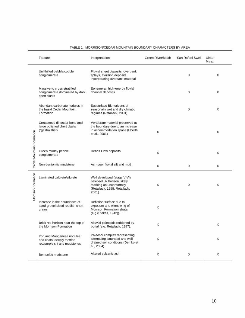
Table 1
TABLE 1. MORRISON/CEDAR MOUNTAIN BOUNDARY CHARACTERS BY AREA
Feature Interpretation Green River/Moab San Rafael Swell Uinta Mtns.
Unlithified pebble/cobble conglomerate
Fluvial sheet deposits, overbank splays, avulsion deposits incorporating overbank material
X X
Massive to cross stratified conglomerate dominated by dark chert clasts
Ephemeral, high-energy fluvial channel deposits X X
Abundant carbonate nodules in the basal Cedar Mountain Formation
Subsurface Bk horizons of seasonally wet and dry climatic regimes (Retallack, 2001)
X X
Cretaceous dinosaur bone and large polished chert clasts (“gastroliths”)
Vertebrate material preserved at the boundary due to an increase in accommodation space (Eberth et al., 2001) X X
Green muddy pebble conglomerate
Debris Flow deposits X X
Ced
ar M
ount
ain
Form
atio
n
Non-bentonitic mudstone Ash-poor fluvial silt and mud X X X
Laminated calcrete/silcrete Well developed (stage V-VI) paleosol Bk horizon, likely marking an unconformity (Retallack, 1998; Retallack, 2001).
X X X
Increase in the abundance of sand-gravel sized reddish chert grains
Deflation surface due to exposure and winnowing of Morrison Formation strata (e.g.(Stokes, 1942))
X
Brick red horizon near the top of the Morrison Formation
Alluvial paleosols reddened by burial (e.g. Retallack, 1997). X X
Iron and Manganese nodules and coats, deeply mottled red/purple silt and mudstones
Paleosol complex representing alternating saturated and well-drained soil conditions (Demko et al., 2004)
X X
Mor
rison
For
mat
ion
Bentonitic mudstone
Altered volcanic ash X X X
10

Figure 3. Morrison Formation/Cedar Mountain Formation boundary study index map. Black dots mark Morrison Formation/Cedar Mountain Formation study locations.
11
mounted clinometer. Section thicknesses range from 10 to 100 meters. All measured
sections cover the uppermost Morrison Formation and lowermost Cedar Mountain
Formation. Additionally, many cover the entire Cedar Mountain Formation. Coordinates
were taken with a handheld GPS receiver (1983 North American Datum [NAD 83]) and
plotted with ArcGIS software.
Results
Green River-Moab
Morrison Formation
The Morrison /Cedar Mountain boundary from Green River, Utah to the Utah-
Colorado border has a very consistent, well developed expression (Figs. 4 and 5). The
upper 15 m of Morrison Formation is characterized by a significant increase in the
abundance of gravel-sized material and in the degree of paleosol development relative to
the underlying portions of the Brushy Basin Member (Fig. 4). Isolated channelized
conglomerates and sand/gravel sized chert pebble lags are present and increase in
abundance up to the boundary. Maximum channel widths vary from a few to tens of
meters. Many of the chert pebbles are coated with a metallic gray/blue manganese
coating distinctive from chert found in the overlying Cedar Mountain Formation and
underlying Morrison Formation. This part of the section also displays intense mottling
and iron enrichments in the form of mustard colored (10YR 6/6, GSA Rock Color Chart
Value) and blackish red (5R 2/2) stains and concretions. Heavily rooted horizons are
apparent primarily in sand-rich intervals. While the Morrison Formation paleosols are
not calcareous, in approximately 50% of our sections the paleosols are capped by a 1-3
12
meter thick carbonate horizon (Fig. 6). This likely represents Early Cretaceous climatic
and hydrologic overprinting of the Morrison paleosol sequence (Demko et al., 2004).
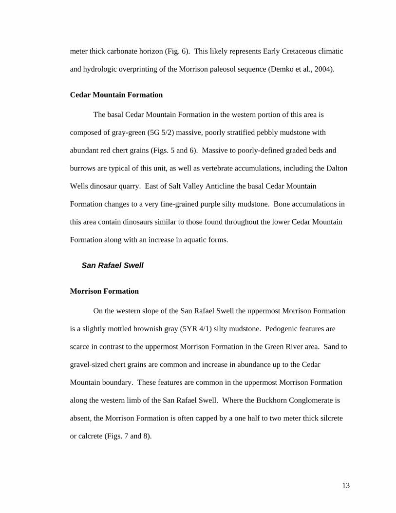
Cedar Mountain Formation
The basal Cedar Mountain Formation in the western portion of this area is
composed of gray-green (5G 5/2) massive, poorly stratified pebbly mudstone with
abundant red chert grains (Figs. 5 and 6). Massive to poorly-defined graded beds and
burrows are typical of this unit, as well as vertebrate accumulations, including the Dalton
Wells dinosaur quarry. East of Salt Valley Anticline the basal Cedar Mountain
Formation changes to a very fine-grained purple silty mudstone. Bone accumulations in
this area contain dinosaurs similar to those found throughout the lower Cedar Mountain
Formation along with an increase in aquatic forms.
San Rafael Swell
Morrison Formation
On the western slope of the San Rafael Swell the uppermost Morrison Formation
is a slightly mottled brownish gray (5YR 4/1) silty mudstone. Pedogenic features are
scarce in contrast to the uppermost Morrison Formation in the Green River area. Sand to
gravel-sized chert grains are common and increase in abundance up to the Cedar
Mountain boundary. These features are common in the uppermost Morrison Formation
along the western limb of the San Rafael Swell. Where the Buckhorn Conglomerate is
absent, the Morrison Formation is often capped by a one half to two meter thick silcrete
or calcrete (Figs. 7 and 8).
13
Figure 4. Uppermost Morrison interval in the Green River-Moab area. A) Yellow and red iron concretions in a mottled purple-green matrix. B) Stacked succession of paleosols capped by carbonate cap. C) Root traces in channelized sandstone overlain by pedogenically overprinted sandstone. D) Small channelized gravel deposits in red paleosol horizons.
14
Figure 5. The basal Cedar Mountain Formation near Green River and Moab, Utah. A) Typical basal Cedar Mountain lithology composed of poorly sorted sand and gravel in a green fine-grained matrix. B) Invertebrate burrow in same matrix as A. C) Basal Cedar Mountain Formation with bones and “gastroliths”. D) Fine-grained Cedar Mountain Formation underlain by purple, iron stained Morrison paleosol. E) Bone and “gastrolith” bearing horizon resting on poorly developed Morrison paleosol.
15
Figure 6. Measured sections from the Green River to Moab area showing sedimentologic and pedogenic features of the Morrison/Cedar Mountain boundary. Sections S4, S14, and S15 adapted from Stikes (2003).
Figure 6
16
Cedar Mountain Formation
Throughout this area conglomeratic material is common in the basal Cedar
Mountain Formation. The Buckhorn Conglomerate and other conglomeratic units here
are characterized by chert clasts in various shades of white, gray and brown. Clast size
generally fines upward from ~5 cm pebbles to medium sand. The expression of
channelized conglomerates outside of the main Buckhorn Conglomerate trend at the
boundary is typical; however the degree to which the conglomerates are cemented varies.
The Buckhorn Conglomerate and other clean conglomerates (small amounts of clay) are
usually carbonate cemented. Occasionally cementation is so pervasive that the rock has a
micritic texture. Channelized conglomerates are not always obvious and many with clay
in the interstices readily weather to a slope. Nested, dish-like laminated caliche layers are
found toward the top of the Buckhorn Conglomerate together with laminated siliceous
horizons similar to those described in the Morrison Formation (Fig. 7 C-F). Above the
conglomerates, the Cedar Mountain Formation is dominantly a fine-grained, carbonate
nodule-bearing unit with isolated, channelized sandstone bodies (Fig. 8). Carbonate
nodules, pastel coloration and, in a general sense, a less bentonitic clay mineralogy
distinguish the Cedar Mountain Formation from the Morrison Formation in areas where
the Buckhorn Conglomerate is absent.
Uinta Mountains
In the vicinity of the Uinta Mountains the Morrison Formation/Cedar Mountain
Formation contact has a character that is similar to the boundary in the Green River-
Moab area, but the features are weakly developed (Figs. 9 and 10).
17
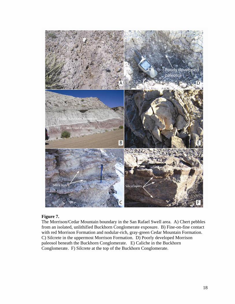
Figure 7. The Morrison/Cedar Mountain boundary in the San Rafael Swell area. A) Chert pebbles from an isolated, unlithified Buckhorn Conglomerate exposure. B) Fine-on-fine contact with red Morrison Formation and nodular-rich, gray-green Cedar Mountain Formation. C) Silcrete in the uppermost Morrison Formation. D) Poorly developed Morrison paleosol beneath the Buckhorn Conglomerate. E) Caliche in the Buckhorn Conglomerate. F) Silcrete at the top of the Buckhorn Conglomerate.
18
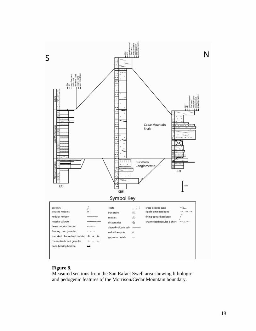
Figure 8 Figure 8. Measured sections from the San Rafael Swell area showing lithologic and pedogenic features of the Morrison/Cedar Mountain boundary.
19
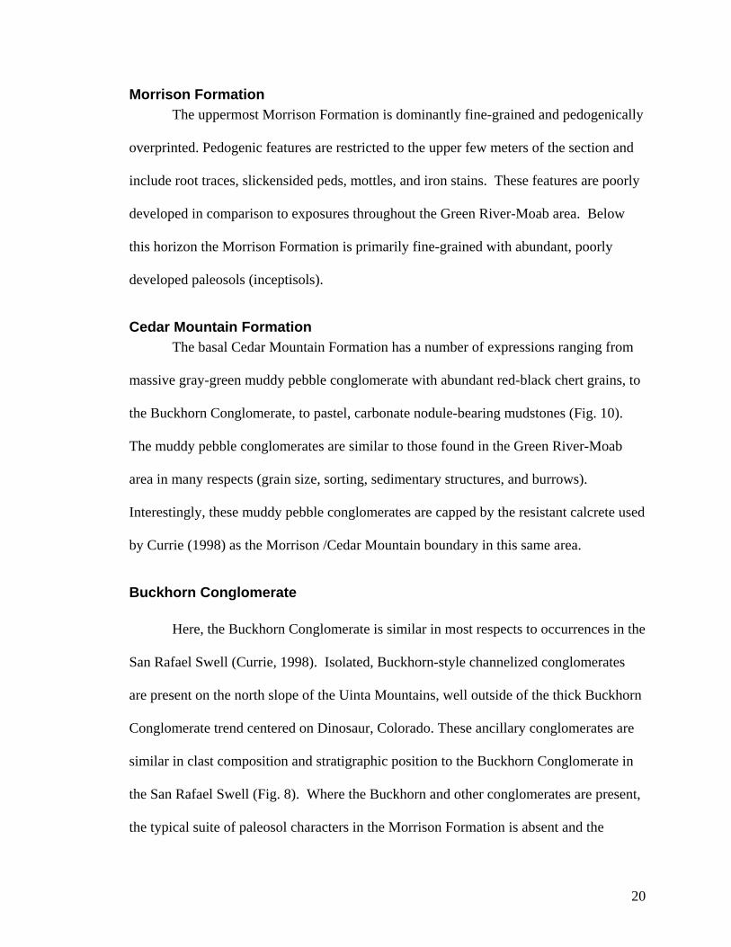
Morrison Formation The uppermost Morrison Formation is dominantly fine-grained and pedogenically
overprinted. Pedogenic features are restricted to the upper few meters of the section and
include root traces, slickensided peds, mottles, and iron stains. These features are poorly
developed in comparison to exposures throughout the Green River-Moab area. Below
this horizon the Morrison Formation is primarily fine-grained with abundant, poorly
developed paleosols (inceptisols).
Cedar Mountain Formation The basal Cedar Mountain Formation has a number of expressions ranging from
massive gray-green muddy pebble conglomerate with abundant red-black chert grains, to
the Buckhorn Conglomerate, to pastel, carbonate nodule-bearing mudstones (Fig. 10).
The muddy pebble conglomerates are similar to those found in the Green River-Moab
area in many respects (grain size, sorting, sedimentary structures, and burrows).
Interestingly, these muddy pebble conglomerates are capped by the resistant calcrete used
by Currie (1998) as the Morrison /Cedar Mountain boundary in this same area.
Buckhorn Conglomerate
Here, the Buckhorn Conglomerate is similar in most respects to occurrences in the
San Rafael Swell (Currie, 1998). Isolated, Buckhorn-style channelized conglomerates
are present on the north slope of the Uinta Mountains, well outside of the thick Buckhorn
Conglomerate trend centered on Dinosaur, Colorado. These ancillary conglomerates are
similar in clast composition and stratigraphic position to the Buckhorn Conglomerate in
the San Rafael Swell (Fig. 8). Where the Buckhorn and other conglomerates are present,
the typical suite of paleosol characters in the Morrison Formation is absent and the
20
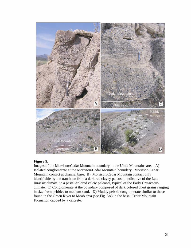
Figure 9. Images of the Morrison/Cedar Mountain boundary in the Uinta Mountains area. A) Isolated conglomerate at the Morrison/Cedar Mountain boundary. Morrison/Cedar Mountain contact at channel base. B) Morrison/Cedar Mountain contact only identifiable by the transition from a dark red clayey paleosol, indicative of the Late Jurassic climate, to a pastel-colored calcic paleosol, typical of the Early Cretaceous climate. C) Conglomerate at the boundary composed of dark colored chert grains ranging in size from pebbles to medium sand. D) Muddy pebble conglomerate similar to those found in the Green River to Moab area (see Fig. 5A) in the basal Cedar Mountain Formation capped by a calcrete.
21
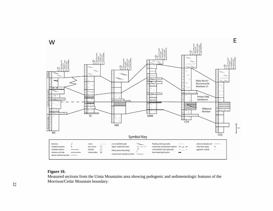
Figure 10. Measured sections from the Uinta Mountains area showing pedogenic and sedimentologic features of the Morrison/Cedar Mountain boundary.
Figure 10
22
Morrison Formation is a green-yellow silty mudstone.
Discussion
Upper Morrison Unconformity
The thick interval of interbedded gravel and mudstone overprinted by intense
paleosol development at the top of the Morrison Formation suggests that sediment
preservation was reduced, but not completely inhibited in the Late Jurassic. A reduction
in accommodation space in the Late Jurassic foreland basin could account for both
observations.
Gravel Abundance Sequence stratigraphic models based on changes in base-level have been applied
to terrestrial sequences where no influence from sea-level is apparent. In these models,
as fluvial systems progressively fill the accommodation space, sediment bypass occurs
creating an upsection increase in grain size (Shanley and McCabe, 1994; Shanley and
McCabe, 1995; Currie, 1997; Shanley and McCabe, 1998; Eberth et al., 2001). The
uppermost Morrison Formation follows this pattern as it transitions from dominantly
bentonitic, silty mudstones, to siltstone, sand and gravel at the top (Fig. 4). Winslow and
Heller (1987) reported a similar increase in grain-size near the top of the Morrison
Formation and into the Cloverly Formation in Wyoming and also attributed it to a
reduction in accommodation space.
Paleosol Complex Reduced accommodation space in the late Morrison Formation basin allowed for
little preservation of new sediment. Consequently, the upper Morrison Formation
23
sediments were subject to pedogenic processes for a significant period of time in the Late
Jurassic climatic regime (Figs. 11 and 12). Iron stains and intense mottles are extensively
developed in the uppermost Morrison Formation (Demko et al., 2004) and are typical of
alternating periods of saturated and well-drained soil conditions (e.g. Vepraskas, 1994).
The thick carbonate cap at the top of the paleosol complex throughout much of the Green
River-Moab area is likely an overprint of the Cretaceous paleoclimatic and
paleohydrologic system (Currie, 1998; Demko et al., 2004). The thickness and
morphological expression of the carbonate cap is indicative of a period of soil
development up to 105-106 years (e.g. Retallack, 1998). Thus, the time represented by
the carbonate cap and the Morrison paleosols combined is likely on the order of millions
of years.
Fluvial Incision While the uppermost Morrison Formation has a consistent expression throughout
the Green River-Moab area, these features are absent in outcrops to the north and south.
Intense fluvial incision in the Early Cretaceous likely removed much of the paleosol
complex on a regional basis, only preserving it in the drainage divides (Demko et al.,
2004). The Buckhorn paleovalley was likely the main fluvial system contributing to the
erosion of the Morrison Formation paleosol complex. Outside of the main Buckhorn
paleovalley, other smaller fluvial/debris flow systems partially or completely removed
the paleosols (Fig. 12). An example of this is the Dalton Wells dinosaur quarry, where
bone-laden debris flows excised most of the Morrison Formation paleosol complex
(Eberth et al., 2006). Similar lithologies to the Dalton Wells quarry in the basal Cedar
Mountain Formation are found near Green River, Utah and lack an underlying, well-
24
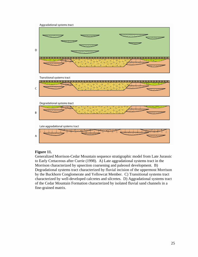
Figure 11. Generalized Morrison-Cedar Mountain sequence stratigraphic model from Late Jurassic to Early Cretaceous after Currie (1998). A) Late aggradational systems tract in the Morrison characterized by upsection coarsening and paleosol development. B) Degradational systems tract characterized by fluvial incision of the uppermost Morrison by the Buckhorn Conglomerate and Yellowcat Member. C) Transitional systems tract characterized by well-developed calcretes and silcretes. D) Aggradational systems tract of the Cedar Mountain Formation characterized by isolated fluvial sand channels in a fine-grained matrix.
25
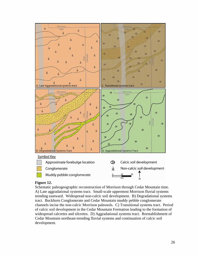
Figure 12. Schematic paleogeographic reconstruction of Morrison through Cedar Mountain time. A) Late aggradational systems tract. Small-scale uppermost Morrison fluvial systems trending eastward. Widespread non-calcic soil development. B) Degradational systems tract. Buckhorn Conglomerate and Cedar Mountain muddy pebble conglomerate channels incise the non-calcic Morrison paleosols. C) Transitional systems tract. Period of calcic soil development in the Cedar Mountain Formation leading to the formation of widespread calcretes and silcretes. D) Aggradational systems tract. Reestablishment of Cedar Mountain northeast-trending fluvial systems and continuation of calcic soil development.
26
developed paleosol complex. Thus, the presence of the bone-filled debris flows is
indicative of a period of erosion similar to that caused by the Buckhorn fluvial system.
Other areas that have lower energy deposits incised the paleosol complex, but did not
completely remove it (Fig. 5D).
Salt Tectonics Salt-tectonics may have played a role in the preservation of the boundary
paleosols in the Green River and San Rafael Swell areas. Salt-induced mini-basins have
been suggested to explain the abundance of lacustrine facies in the Morrison Formation
and the Cedar Mountain Formation near Moab, Utah (Aubrey, 1996; Eberth et al., 2006).
These mini-basins could have inhibited the development of the paleosol complex by
increasing accommodation space and sediment preservation potential (Aubrey, 1996;
Johnson and Aubrey, 1994), thus inhibiting paleosol development. Additionally, lakes
formed in the topographic depressions (e.g. Eberth et al., 2006) would have
fundamentally inhibited paleosol development.
Soil Features in the Uinta Mountains In the Uinta Mountains the paleosols are similar to those in the Green River-Moab
area, but less well developed suggesting a shorter period of exposure or more intense
erosion. In some areas the paleosol features are completely absent, which favors the
interpretation that they have been eroded out.
Buckhorn Discussion The relationship between the Buckhorn Conglomerate and the Morrison/Cedar
Mountain Formation has been a topic of debate since its original description (Stokes,
1944). Some authors place it within the Morrison Formation (Aubrey, 1998; Ayers and
27
Nadon, 2003), others at the base of the Cedar Mountain Formation (Currie, 1997). The
Buckhorn Conglomerate is not underlain by the paleosol package found in the uppermost
Morrison throughout the Green River-Moab area. This can be accounted for in one of
two ways: 1) the Buckhorn depositional system may postdate the Morrison Formation
(Currie, 1997), in which case it is likely that the paleosol features were eroded out, or 2)
the Buckhorn Conglomerate may be contemporaneous with the Morrison Formation
(Aubrey, 1998), in which case, the features would not have been developed in the
Morrison Formation because of erosion. In this scenario, some expression of the
pedogenic features in the fine-grained sections would be expected in the Buckhorn
Conglomerate because they were deposited contemporaneously. The absence of
Morrison Formation paleosol features within the Buckhorn Conglomerate supports
conclusion (1), that the Buckhorn Conglomerate eroded the paleosols and post-dates the
Morrison Formation.
The Buckhorn Conglomerate also displays a thick silica/carbonate cap in the
vicinity of the San Rafael Swell (Fig. 7 E and F). This carbonate cap is similar to the
carbonate cap found at the top of the paleosol complex throughout the Green River-Moab
area (Fig. 4B) and variably within the basal Cedar Mountain Formation. This suggests
that the Buckhorn Conglomerate-basal Cedar Mountain Formation records a second
unconformity marked by a prolonged period of calcrete development and little-no
sedimentation in the Early Cretaceous. The presence of a basal erosional unconformity
and the presence of calcretes support the sequence stratigraphic model proposed by
(Currie, 1997) as well as our conclusion that the Buckhorn Conglomerate post-dates the
Morrison Formation. The variability in the stratigraphic position of the calcretes east of
28
the San Rafael Swell and the presence of a calcrete at the top of the Buckhorn
Conglomerate indicate that the Buckhorn Conglomerate and Yellowcat Member are
partially time equivalent.
Widespread Buckhorn Paleovalley Currie (1998) described the Buckhorn paleovalley as a 25-km-wide valley
trending NE across central Utah. While it is true that the main Buckhorn Conglomerate
is relatively well confined, the Buckhorn depositional system as a whole was not nearly
so restricted. Isolated channelized conglomerates persist at least as far south as Capitol
Reef National Park. Not all of the incision into the Morrison Formation was filled with
coarse-grained material. Near the southern end of the San Rafael Swell there are distinct,
channelized incisions into the uppermost bentonitic Morrison Formation sediments.
Some of these channels are filled with fine-grained sediment and carbonate nodules
typical of the Cedar Mountain Formation (Fig. 13). Channelized conglomerates at the
boundary also occur in other outcrops in the Uinta Mountain area (Haddox, 2004) (Fig.
9A). These smaller, more widely spaced fluvial incisions were likely feeder systems into
the main Buckhorn paleovalley and show the widespread nature of erosion of the
uppermost Morrison Formation during the Early Cretaceous. Fluvial incision of this
magnitude also accounts for the small number of Morrison Formation outcrops where the
paleosol complex is preserved.
Yellowcat Member Discussion The preservation of fine-grained sediment and dinosaur bone in the Yellowcat
Member (Kirkland, et al., 2005; Eberth et al., 2006) above the unconformity suggest an
29
increase in accommodation space following the Buckhorn Conglomerate (e.g. Rogers and
Kidwell, 1998; Eberth et al., 2001). These lines of evidence, together with the intense
paleosol development in the uppermost Morrison Formation support the sequence-
stratigraphic model for the Cedar Mountain Formation proposed by Currie (1997): the
upper Morrison Formation/Buckhorn Conglomerate interval records late
aggradational/degradational systems tracts respectively, and the Cedar Mountain
Formation records a transitional to aggradational systems tract (Figs. 11 and 12).
Yellowcat Member and Calcretes The Yellowcat Member in the Green River-Moab area has been interpreted as a
mixture of lacustrine sediments and lake-margin debris flows (Eberth et al., 2006).
Similar lithologies and sedimentary structures are seen in the lowest Cedar Mountain
Formation in the Uinta Mountains area, suggesting that debris flows were common
during the initial phases of Cedar Mountain deposition.
Although a precise chronostratigraphic correlation between these units is
problematic, a genetic relationship between them is likely. The stratigraphic position of
this unit below the calcrete suggests that the current sequence stratigraphic model needs
refinement. Currie (1997) proposed two genetically related sequences (LK1 and LK2)
for the Cedar Mountain Formation. The Buckhorn Conglomerate comprises the LK1
sequence which is terminated by the well-developed calcrete. The Cedar Mountain
Formation above the calcrete comprises the LK2 sequence. Our study suggests that
Cedar Mountain Formation deposition during the LK1 sequence was more widespread
than Currie’s model suggests and that debritic sedimentation, particularly outside of the
main Buckhorn paleovalley, was an integral part of the LK1 depositional system
30
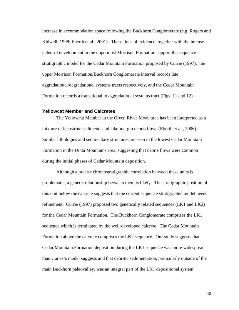
Figure 13. Fine-grained channel incised into the Morrison Formation near the southern end of the San Rafael Swell. The channel occurs at the Morrison/Cedar Mountain boundary along with other isolated conglomerates, which are correlative with the Buckhorn Conglomerate.
(Figs. 11 and 12). This conclusion is also supported by the presence of debritic
lithologies interbedded with the Buckhorn Conglomerate in the San Rafael Swell. We
propose that the Buckhorn Conglomerate and the Yellowcat Member are associated
facies of the basal Cedar Mountain Formation based on the relationship between a muddy
pebble conglomerate associated with a calcrete in the Green River-Moab and Uinta
Mountains areas, the presence of similar calcretes in the Buckhorn Conglomerate, and the
presence of interbedded muddy pebble conglomerate in the Buckhorn Conglomerate in
the San Rafael Swell.
31
Conclusions Our study of the Morrison/Cedar Mountain boundary leads us to the following
conclusions:
1) A suite of sedimentologic and stratigraphic features characterizes the Morrison
/Cedar Mountain boundary for each area. While the features are not identical in each
area they are internally consistent and can be accounted for by current sequence
stratigraphic models.
2) The uppermost Morrison Formation has features indicative of intense paleosol
development in areas not fluvially incised. In areas with high degrees of fluvial incision
the paleosol package has been removed and only poorly developed paleosols are
preserved at the boundary.
4) The basal Cedar Mountain Formation varies from coarse conglomeratic
material of the Buckhorn Conglomerate to muddy pebble conglomerate or carbonate
nodule-bearing silty mudstones of the Yellowcat Member.
3) Jurassic paleosol features combined with the Early Cretaceous carbonate cap
indicate a period of post Morrison exposure on the order of millions of years.
5) These facies trends indicate an Early Cretaceous progression from
degradational to transitional systems tracts in the foreland basin following Morrison
Formation deposition.
6) Debritic sedimentation is a characteristic feature of the basal Cedar Mountain
Formation and may be the key to deciphering the relationship between the Buckhorn
Conglomerate and the Yellowcat Member.
These features provide a framework for deciphering the Morrison/Cedar
Mountain contact, which will aid in paleontologic prospecting in the fossil-rich basal
32
Cedar Mountain Formation. By providing a uniform system for assessing the boundary,
this framework will also aid subsequent paleoenvironmental and stratigraphic studies of
the Cedar Mountain Formation and its dinosaur fauna. It also shows that despite the
sometimes cryptic nature of the Morrison/Cedar Mountain contact, detailed
sedimentologic, pedogenic and paleontologic information can be combined to accurately
decipher the boundary. This methodology can now be applied to other stratigraphic
successions with enigmatic formational boundaries.
References
Aubrey, W.M., 1998, A newly discovered, widespread fluvial facies and unconformity marking the Upper Jurassic/Lower Cretaceous Boundary, Colorado Plateau: Modern Geology, v. 22, p. 209-233.
Aubrey, W.M., 1996, Stratigraphic architecture and deformational history of Early Cretaceous foreland basin, Eastern Utah and Southwestern Colorado, in Huffman, A.C., Jr., Lund, W.R. and Godwin, L.H., eds., Geology and Resources of the Paradox Basin: Utah, Utah Geological Association Guidebook, p. 211-220.
Ayers, J.D., and Nadon, G.C., 2003, Lithologic criteria for locating the J/K boundary within the nonmarine lower Cedar Mountain Formation, San Rafael Swell, Utah; Geological Society of America, 2003 annual meeting: Abstracts with Programs - Geological Society of America, v. 35, p. 426.
Christiansen, E.H., Kowallis, B.J., and Barton, M.D., 1994, Temporal and spatial distribution of volcanic ash in Mesozoic sedimentary rocks of the western interior: an alternative record of Mesozoic magmatism, in Caputo, M.V., Peterson, J.A. and Franczyk, K.J., eds., Mesozoic systems of the Rocky Mountain Region, USA: Rocky Mountain Section, Society of Economic Paleontologists and Mineralogists, Special Publication, p. 73-93.
Coffin, R.C., 1921, Radium, uranium, and vanadium deposits of southwestern Colorado: Bulletin - Colorado Geological Survey, Department of Natural Resources, v. 16, .
Craig, L.C., 1961, Discussion of 'Dakota Group of Colorado Plateau,', by Young R.G.: American Association of Petroleum Geologists Bulletin, v. 45, p. 1582-1584.
Craig, L.C., 1955, Stratigraphy of the Morrison and related formations, Colorado Plateau region; a preliminary report: U.S.Geological Survey Bulletin, p. 125-168.
33
Currie, B.S., 1998, Upper Jurassic-Lower Cretaceous Morrison and Cedar Mountain formations, NE Utah-NW Colorado; relationships between nonmarine deposition and early Cordilleran foreland-basin development: Journal of Sedimentary Research, v. 68, p. 632-652.
Currie, B.S., 1997, Sequence stratigraphy of nonmarine Jurassic-Cretaceous rocks, central Cordilleran foreland-basin system: Geological Society of America Bulletin, v. 109, p. 1206-1222.
DeCelles, P.G., 2004, Late Jurassic to Eocene evolution of the Cordilleran thrust belt and foreland basin system, western U.S.A: American Journal of Science, v. 304, p. 105-168.
Demko, T.M., Currie, B.S., and Nicoll, K.A., 2004, Regional paleoclimatic and stratigraphic implications of paleosols and fluvial/overbank architecture in the Morrison Formation (Upper Jurassic), Western Interior, USA: Sedimentary Geology, v. 167, p. 115-135.
Eberth, D.A., Britt, B.B., Scheetz, R.D., Stadtman, K.L., and Brinkman, D.B., 2006, Dalton Wells: Geology and significance of debris-flow-hosted dinosaur bonebeds (Cedar Mountain Formation, eastern Utah, USA): Palaeogeography, Palaeoclimatology, Palaeoecology, .
Eberth, D.A., Brinkman, D.B., Chen, P., Yuan, F., Wu, S., Li, G., and Cheng, X., 2001, Sequence stratigraphy, paleoclimate patterns, and vertebrate fossil preservations in Jurassic-Cretaceous strata of the Junggar Basin, Xinjiang autonomous region, People's Republic of China: Canadian Journal of Earth Sciences = Revue Canadienne Des Sciences De La Terre, v. 38, p. 1627-1644.
Emmons, S.F., Eldridge, G.H., and Cross, C.W., 1896, Geology of the Denver Basin in Colorado: Monograph - U.S.Geological Survey.
Haddox, D., 2004, Mapping the Dry Fork and Steinaker Reservoir 7.5' quadrangles, Vernal, Utah: Abstracts with Programs - Geological Society of America, v. 36, p. 21.
Horton, B.K., and DeCelles, P.G., 1997, The modern foreland basin system adjacent to the Central Andes: Geology Boulder, v. 25, p. 895-898.
Johnson, B., and Aubrey, W.M., 1994, Stratigraphic evidence for Early Cretaceous normal faulting over the Cache Valley salt structure, Paradox Basin, Utah: Annual Meeting Abstracts - American Association of Petroleum Geologists and Society of Economic Paleontologists and Mineralogists, v. 1994, p. 181.
Kirkland, J.I., 1996, Biogeography of western North America's Mid-Cretaceous dinosaur faunas; losing European ties and the first great Asian-North American interchange: Journal of Vertebrate Paleontology, v. 16, p. 45.
34
Kirkland, J.I., Britt, B.B., Burge, D.L., Carpenter, K., Cifelli, R.L., DeCourten, F.L., Eaton, J., Hasiotis, S., and Lawton, T., 1997, Lower to Middle Cretaceous dinosaur faunas of the central Colorado Plateau; a key to understanding 35 million years of tectonics, sedimentology, evolution and biogeography: Geology Studies, v. 42, Part 2, p. 69-103.
Kirkland, J.I., Cifelli, R.L., Britt, B.B., Burge, D.L., DeCourten, F.L., Eaton, J.G., Parrish, J.M., Cifelli, R.L., Britt, B.B., Burge, D.L., DeCourten, F.L., Eaton, J.G., and Parrish, J.M., 1999, Distribution of vertebrate faunas in the Cedar Mountain Formation, east-central Utah: Miscellaneous Publication - Utah Geological Survey, v. 99-1, p. 201-217.
Kirkland, J.I., Zanno, L.E., Sampson, S.D., Clark, J.M., and DeBlieux, D.D., 2005, A primitive therizinosauroid dinosaur from the Early Cretaceous of Utah: Nature (London), v. 435, p. 84-87.
Ludvigson, G.A., Gonzalez, L.A., Kirkland, J.I., and Joeckel, R.M., 2002, The terrestrial stable isotopic record of Aptian-Albian OAE1b in palustrine carbonates of the Cedar Mountain Formation, Utah: Implications for continental paleohydrology: Program Abstracts: p. 54.
McGookey, D.P., Haun, J.D., Hale, L.A., Goodell, H.G., McCubbin, D.G., Weimer, R.J., and Wulf, G.R., 1972, Cretaceous system, in Geologic Atlas of the Rocky Mountain region: United States (USA), Rocky Mt. Assoc. Geol., Denver, p. 190-228.
Molenaar, C.M., and Cobban, W.A., 1991, Middle Cretaceous stratigraphy on the south side of the Uinta Basin, east-central Utah: Utah Geological Association Publication, v. 19, p. 29.
Peterson, J.A., 1972, Jurassic system, in Geologic Atlas of the Rocky Mountain region: United States (USA), Rocky Mt. Assoc. Geol., Denver, p. 177-189.
Retallack, G.J., 2001, Soils of the Past: An introduction to paleopedology: Oxford, England, Blackwell Science Ltd, p. 404.
Retallack, G.J., 1997, A colour guide to paleosols Chichester, England, John Wiley & Sons, p. 175.
Retallack, G.J., 2005, Pedogenic carbonate proxies for amount and seasonality of precipitation in paleosols: Geology, v. 33, p. 333-336.
Retallack, G.J., 1998, Fossil soils and completeness of the rock and fossil records, in Donovan, S.K. and Paul, C.R.C., eds., The adequacy of the fossil record: United Kingdom (GBR), John Wiley & Sons, Chichester, United Kingdom (GBR), p. 133-163.
35
Rogers, R.R., and Kidwell, S.M., 1998, Testing the association between fossil lags and discontinuity surfaces; a case study in the Upper Cretaceous of Montana: Journal of Vertebrate Paleontology, v. 18, p. 72.
Royse, F.,Jr, 1993, Case of the phantom foredeep; Early Cretaceous in west-central Utah: Geology (Boulder), v. 21, p. 133-136.
Shanley, K.W., and McCabe, P.J., 1998, Relative role of eustasy, climate, and tectonism in continental rocks: Special Publication - SEPM Society for Sedimentary Geology, v. 59, 234 p.
Shanley, K.W., and McCabe, P.J., 1995, Sequence stratigraphy of Turonian-Santonian strata, Kaiparowits Plateau, southern Utah, U.S.A.; implications for regional correlation and foreland basin evolution: AAPG Memoir, v. 64, p. 103-135.
Shanley, K.W., and McCabe, P.J., 1994, Perspectives on the sequence stratigraphy of continental strata: AAPG Bulletin, v. 78, p. 544-568.
Smith, D.L., Miller, E.L., Wyld, S.J., and Wright, J.E., 1993, Progression and timing of Mesozoic crustal shortening in the northern Great Basin, Western U.S.A: Field Trip Guidebook - Pacific Section, Society of Economic Paleontologists and Mineralogists, v. 71, p. 389-405.
Smith, E.A., Ludvigson, G.A., Joeckel, R.M., Kirkland, J.I., Carpenter, S.J., Gonzalez, L.A., and Madsen, S.K., 2001, Reconnaissance carbon isotopic chemostratigraphy of pedogenic-palustrine carbonates in the Early Cretaceous Cedar Mountain Formation, San Rafael Swell, eastern Utah: v. 33, p. A445.
Stikes, M. W., 2003, Fluvial facies and architecture of the Poison Strip Sandstone, lower Cretaceous Cedar Mountain Formation, Grand County, Utah [M.S. Thesis]: Northern Arizona University, 147 p.
Stokes, W.L., 1942, Some field observations bearing on the origin of the Morrison gastroliths: Science, v. 95, p. 18-19.
Stokes, W.L., 1952a, Lower Cretaceous in Colorado Plateau: Bulletin of the American Association of Petroleum Geologists, v. 36, p. 1766-1776.
Stokes, W.L., 1952b, Paleogeography of nonmarine Lower Cretaceous in the Rocky Mountains: Geological Society of America Bulletin, v. 63, p. 1345.
Stokes, W.L., 1944, Morrison formation and related deposits in and adjacent to the Colorado Plateau: Geological Society of America Bulletin, v. 55, p. 951-992.
Tschudy, R.H., Tschudy, B.D., and Craig, L.C., 1984, Palynological evaluation of Cedar Mountain and Burro Canyon formations, Colorado Plateau: U.S.Geological Survey Professional Paper, v. P 1281, p. 24.
36
Vepraskas, M.J., 1994, Redoximorphic features for identifying aquic conditions: North Carolina Agricultural Resource Services Technical Bulletin 301.
Winslow, N.S., and Heller, P.L., 1987, Evaluation of unconformities in Upper Jurassic and Lower Cretaceous nonmarine deposits, Bighorn Basin, Wyoming and Montana, U.S.A: Sedimentary Geology, v. 53, p. 181-202.
Young, R.G., 1960, Dakota Group of Colorado Plateau: Bulletin of the American Association of Petroleum Geologists, v. 44, p. 156-194.
37
Chapter 2
Zircon Geochronology of the Morrison/Cedar Mountain Formational Boundary, Moab, Utah
Table of Contents
Abstract .......................................................................................................................................... 40
Introduction.................................................................................................................................... 40
Geologic Setting ............................................................................................................................ 42
Established Morrison and Cedar Mountain Ages .......................................................................... 43
Zircon Methods and Results .......................................................................................................... 44
Samples...................................................................................................................................... 44
Methods ..................................................................................................................................... 44 Analytical Methods ............................................................................................................... 44 40Ar/39Ar Cross Check........................................................................................................... 47
Description of Age Populations.................................................................................................48 Morrison Ages....................................................................................................................... 48 Cedar Mountain Ages ........................................................................................................... 49
Discussion...................................................................................................................................... 50
Basal Cedar Mountain Age........................................................................................................ 50 Morrison /Cedar Mountain Unconformity ............................................................................ 51 Intraformational Unconformities........................................................................................... 52
Faunal Correlations ................................................................................................................... 53
Conclusions.................................................................................................................................... 56
Acknowledgements........................................................................................................................ 57
References...................................................................................................................................... 58
38

List of Tables
Table 1 ........................................................................................................................................... 46 Table 2 ........................................................................................................................................... 56
List of Figures
Figure 1. ......................................................................................................................................... 45 Figure 2. ......................................................................................................................................... 48 Figure 3. ......................................................................................................................................... 50 Figure 4. ......................................................................................................................................... 54 Figure 5. ......................................................................................................................................... 55
39
Abstract The Cedar Mountain Formation has the potential to provide information critical to
Early Cretaceous dinosaur evolution in North America. Thus far, radiometric ages for
the formation have been available for only the uppermost portions of this 40-100 meter-
thick fluvial package. In this paper we present radiometric 206Pb/238U zircon ages for the
basal Yellowcat Member of the formation, near Moab, Utah. The Dalton Wells dinosaur
quarry occurs in the Yellowcat Member along with numerous other fossil assemblages.
Zircons collected from the Dalton Wells quarry and a correlative eggshell horizon place
the age of the basal Cedar Mountain Formation and its fauna near the Barremian/Aptian
boundary at 124 Ma. This permits for the first time a temporal correlation of the
Yellowcat fauna and shows that it is time equivalent with the prolific and
paleobiologically diverse Yixian Formation, of Liaoning, China. The age of the
uppermost Morrison in this area is ~148 Ma, thus constraining the duration of the
Morrison/Cedar Mountain unconformity to 24 Myr from 148-124 Ma. This time period
correlates with a lull in contractional tectonic activity and magmatism in western North
America. This provides more data supporting the fundamental link between magmatism
and sediment preservation in western North America and has application to other
sedimentary successions associated with magmatic arcs.
Introduction
The Cedar Mountain Formation is a classic example of a terrestrial fluvial
succession deposited in a foreland basin (Currie, 1998) and contains an abundance of
Early Cretaceous dinosaurs unrivaled in North America (Kirkland et al., 1997; Eberth et
al., 2006). Constraining the age of this prolific accumulation of dinosaur material has
40
been difficult because of the paucity of volcanic ash and age diagnostic fossils. Current
age assessments for the Cedar Mountain Formation are largely based on biostratigraphic
data and biased toward the upper portions of the unit (Young, 1960; Tschudy et al., 1984;
Cifelli et al., 1997; Eberth et al., 2006). These data and one radiometric age of 98.0 ±
0.07 Ma at the top of the formation (Cifelli et al., 1997) constrain the upper age of the
Cedar Mountain Formation to the Albian-Cenomanian boundary. Vertebrate fossils in
the basal Yellowcat Member of the Cedar Mountain Formation (Kirkland et al., 1997) are
arguably the earliest Cretaceous dinosaur fossils on the Colorado Plateau (Kirkland et al.,
1993) and hold a vital key to understanding the evolution of North American dinosaurs
and their connection to other Early Cretaceous dinosaur groups worldwide. The age of
the Dalton Wells quarry has been regarded as Barremian based primarily on broad
similarities between its dinosaur fauna and the Barremian of Europe (Kirkland et al.,
1993; Kirkland et al., 1999), however, the lack of shared genera and absolute age control
have left this age assessment tenuous (Eberth et al., 2006). The basal Cedar Mountain
Formation has yielded a diverse, dinosaurian fauna that includes relics of Late Jurassic
Morrison sauropod lineages (brachiosaurids and a camarasaurid), a basal macronarian, an
array of theropods including Utahraptor, the largest dromaeosaurid, and a primitive
therizinosaur, which demonstrates a transition from carnivory to herbivory within
theropoda (Kirkland et al., 1997; Kirkland, 2005; Eberth et al., 2006). The absence of
absolute ages has made it impossible to correlate this diverse, sauropod-dominated fauna
with time-equivalent faunas. It also hinders biogeographic and times of origin/extinction
studies.
41
In this paper we present radiometric ages from ash-derived zircons collected from
the uppermost Morrison Formation and lowermost Cedar Mountain Formation near
Moab, Utah. These are the only radiometric ages for the lower Cedar Mountain
Formation making it possible for the first time to compare the lower Cedar Mountain
Formation with time correlative faunas and to test several proposed dinosaurian evolution
hypotheses. These ages also allow us to evaluate causative mechanisms for developing
the Morrison/Cedar Mountain unconformity.
Geologic Setting
The Morrison Formation and Cedar Mountain Formation were deposited in the
interior foreland basin of western North America and consist primarily of pedogenically
altered fluvial and lacustrine sediments and volcanic ash (Emmons et al., 1896; Stokes,
1944; Christiansen et al., 1994; DeCelles, 2004; Demko et al., 2004). The Morrison
Formation was most likely deposited in the backbulge of a Late Jurassic foreland basin
centered on western Utah and eastern Nevada (Royse, 1993; DeCelles, 2004). Well-
preserved volcanic ash layers in the Morrison Formation are abundant and allowed
extensive documentation of its age throughout the Colorado Plateau (Kowallis et al.,
1998). An uppermost Morrison unconformity likely developed as a result of reduced
accommodation space in the foreland basin due to eastward migration of the forebulge,
and post-Morrison uplift of the basin (Currie, 1998; Demko et al., 2004). Interior
propagation of thrusting shifted the Early Cretaceous foreland basin into central and
eastern Utah (Mitra, 1996; Camilleri et al., 1997; Yonkee, 1997; Currie, 1998), where the
Cedar Mountain Formation was deposited. A number of dinosaur bonebeds occur within
42
the basal 10 meters of the Cedar Mountain Formation. The rarity of well-preserved ash
in the Cedar Mountain Formation, which has hitherto hindered dating this formation, may
be a function of an Early Cretaceous lull in volcanic activity in the Sierran magmatic arc
(Bateman, 1992; Christiansen et al., 1994), but may be more likely due to a high degree
of reworking by Cedar Mountain fluvial systems and/or to destruction of ash due to
environmental or diagenetic conditions.
Established Morrison and Cedar Mountain Ages
The age of the Morrison Formation ranges from 155-148 Ma (Kowallis et al.,
1998) throughout the Colorado Plateau and is bracketed by 151-145 Ma in southwestern
Wyoming (Trujillo, 2003). The Cedar Mountain Formation has been regarded as Early
Cretaceous since its original description (Stokes, 1944); however radioisotopic (Cifelli et
al., 1997) and palynologically derived ages (Young, 1960; Tschudy et al., 1984) with
narrow ranges have been reported for only the upper portions of the formation. This bias
is primarily due to an upsection increase in the preservation of ash and age-diagnostic
fossils. In contrast, charophytes, pollen and vertebrate faunal comparisons have been
used to bracket the age of the lower Cedar Mountain Formation to the Kimmeridgian-
Aptian interval (Kirkland et al., 1997; Kirkland et al., 1999; Eberth et al., 2006) and there
was no volcanic ages. These ambivalent ages demonstrate the need for precise
radiometric age control for the basal Cedar Mountain Formation and its dinosaur
assemblage (Eberth et al., 2006).
43
Zircon Methods and Results
Samples Eight zircon samples from the Morrison and Cedar Mountain Formations of the
Colorado Plateau in Utah were analyzed for this study (Table 1 and Fig. 1). Four of the
samples are from the Morrison and Cedar Mountain Formations from the Dalton Wells
area near Moab, Utah. Samples M1 and M2 were collected in the Morrison Formation
immediately below the Morrison /Cedar Mountain contact (Fig. 1A). Samples CM1 and
CM2 are from the Dalton Wells quarry and a correlative eggshell locality, respectively,
both of which occur in the basal Cedar Mountain Formation (Fig. 1A). They are
lithologically similar and composed of gray-green sandy/silty mudstones with abundant
matrix- supported chert grains deposited by debris flows in a lake-margin setting (Eberth
et al., 2006) CM1 and CM2 occur 1.5 and 6 m above the Morrison /Cedar Mountain
contact respectively and provide ages for the basal Cedar Mountain Formation and its
fauna. Together, the Morrison Formation and Cedar Mountain Formation samples
provide dates to assess the duration of the unconformity recognized by Stokes (1944) and
Young (1960).
The other four samples are archived samples from the Morrison, Carmel, and
Temple Cap Formations with published 40Ar/39Ar ages. These samples were used to
independently verify our zircon methods (Table 1).
Methods
Analytical Methods U-Pb geochronology of zircons was conducted by laser ablation multicollector
inductively coupled plasma mass spectrometry at the University of Arizona LaserChron
44
Figure 1. Locality, stratigraphy, and zircon U-Pb ages. A) Index map and geology of the study area showing sample localities. Samples CM1 and M1 are within and below the Dalton Wells quarry, respectively. B) Stratigraphic section showing positions of samples. C) Histograms of zircon ages with superimposed probability-density plots for all new samples in this study; youngest age for each sample is in italics (asymmetric errors are 95% confidence interval errors); only ages less than 200 Ma are shown; n values are the number of analyses in the youngest age/total number of analyses. Geologic map after Doelling (2001). Stratigraphic column from Eberth and others (2006). Abbreviations: PSS = Poison Strip Sandstone.
45
Table 1 TABLE 1. ZIRCON 206Pb/238U AND CONTROL SANIDINE
40Ar/39Ar AGES
Sample ID
Formation
40Ar/39Ar age (Ma)
206Pb/238U age* (Ma)
n†
New Samples CM2 Cedar
Mountain N.A.§
124.2 ± 2.6# 20
+ 4.1 CM1 Cedar Mountain
N.A. 146.6 – 3.9
14
+ 2.8 M2 Morrison N.A. 147.2 – 3.2
39
+ 2.8 M1 Morrison N.A. 147.9 – 2.9
49
Control Samples**
+ 3.6 DQW-21 Morrison 149.93 ± 0.42 146.5 – 3.9
23
+ 3.5 LCM-1 Morrison 151.15 ± 0.50 147.4 – 3.3
20
+ 4.4 GUN-B Carmel 169.09 ± 0.50 167.6 – 3.4
22
+ 5.1 MWCB-14 Temple Cap
171.40 ± 0.6 169.4 – 4.4
21
*Zircon age data reported with asymmetric 95% confidence errors. † n = number of analyses included in zircon age calculations. § N.A. = not applicable # Age calculated using Unmix Ages routine in Isoplot with 2σ error (Ludwig, 2004). ** 40Ar/39Ar ages are from Kowallis and others (1998) and Kowallis and others (2001) and are recalibrated against Fish Canyon Tuff at 28.02.
46
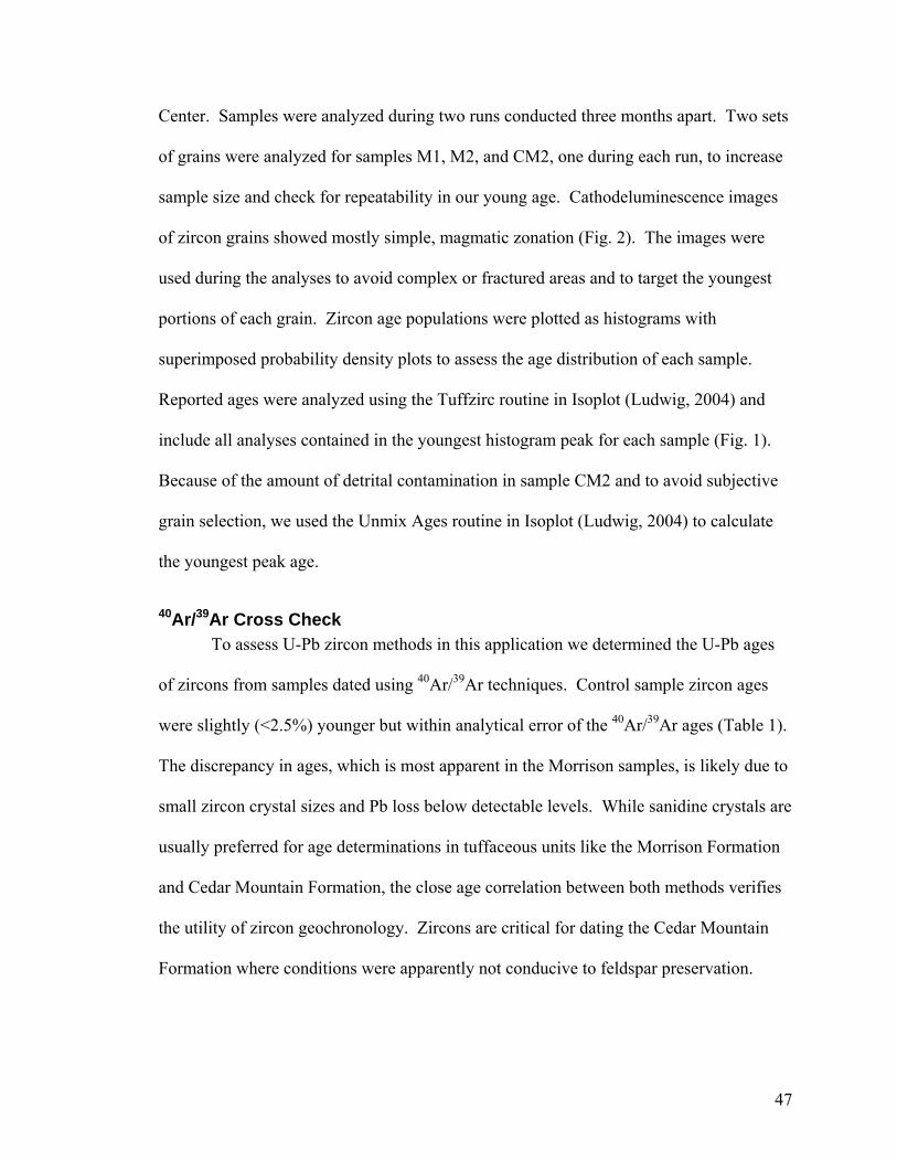
Center. Samples were analyzed during two runs conducted three months apart. Two sets
of grains were analyzed for samples M1, M2, and CM2, one during each run, to increase
sample size and check for repeatability in our young age. Cathodeluminescence images
of zircon grains showed mostly simple, magmatic zonation (Fig. 2). The images were
used during the analyses to avoid complex or fractured areas and to target the youngest
portions of each grain. Zircon age populations were plotted as histograms with
superimposed probability density plots to assess the age distribution of each sample.
Reported ages were analyzed using the Tuffzirc routine in Isoplot (Ludwig, 2004) and
include all analyses contained in the youngest histogram peak for each sample (Fig. 1).
Because of the amount of detrital contamination in sample CM2 and to avoid subjective
grain selection, we used the Unmix Ages routine in Isoplot (Ludwig, 2004) to calculate
the youngest peak age.
40Ar/39Ar Cross Check To assess U-Pb zircon methods in this application we determined the U-Pb ages
of zircons from samples dated using 40Ar/39Ar techniques. Control sample zircon ages
were slightly (<2.5%) younger but within analytical error of the 40Ar/39Ar ages (Table 1).
The discrepancy in ages, which is most apparent in the Morrison samples, is likely due to
small zircon crystal sizes and Pb loss below detectable levels. While sanidine crystals are
usually preferred for age determinations in tuffaceous units like the Morrison Formation
and Cedar Mountain Formation, the close age correlation between both methods verifies
the utility of zircon geochronology. Zircons are critical for dating the Cedar Mountain
Formation where conditions were apparently not conducive to feldspar preservation.
47
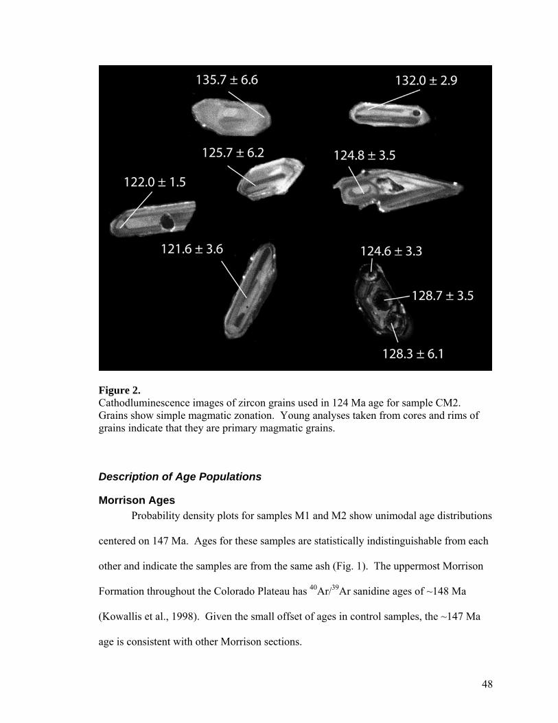
Figure 2. Cathodluminescence images of zircon grains used in 124 Ma age for sample CM2. Grains show simple magmatic zonation. Young analyses taken from cores and rims of grains indicate that they are primary magmatic grains.
Description of Age Populations
Morrison Ages Probability density plots for samples M1 and M2 show unimodal age distributions
centered on 147 Ma. Ages for these samples are statistically indistinguishable from each
other and indicate the samples are from the same ash (Fig. 1). The uppermost Morrison
Formation throughout the Colorado Plateau has 40Ar/39Ar sanidine ages of ~148 Ma
(Kowallis et al., 1998). Given the small offset of ages in control samples, the ~147 Ma
age is consistent with other Morrison sections.
48
Cedar Mountain Ages Sample CM1, from the Dalton Wells quarry in the basal Cedar Mountain
Formation, has a unimodal age peak centered on 146 Ma. A Jurassic peak is expected
because 1) the quarry lithosome rests unconformably on the Morrison Formation, 2) the
sample is from 1 m above the Morrison Formation/Cedar Mountain Formation contact,
and 3) the quarry matrix is composed of slightly reworked Morrison Formation (Eberth et
al., 2006).
Sample CM2 is also from the base of the Cedar Mountain Formation, but 6 m
above the Morrison /Cedar Mountain contact and 1.5 km distant from the Dalton Wells
quarry (Fig. 1). The sample is from a massive, green, silty mudstone that contains
eggshell fragments and partial eggs of a theropod dinosaur (based on rugose
ornamentation). An identical mudstone, sans eggshell, rests conformably on the Dalton
Wells quarry. The Mesozoic age distribution for this sample is more complex than the
other samples, with prominent peaks at 124 Ma, and 145 Ma and a minor peak at 166 Ma.
Zircon crystals with high U content are known to yield abnormal young ages and many of
the analyses in our 124 Ma peak have slightly elevated U concentrations (Fig. 3). The
distinct separation between the 124 Ma and 145 Ma peaks (Fig. 1), however, indicate that
there are two grain populations. Furthermore, eight of the 20 analyses (40%) have low U
concentrations (<500 ppm) and yield a young age. Because our young ages vary only
slightly with U concentration, it is unlikely that they have been affected by Pb loss (Fig.
3).
49
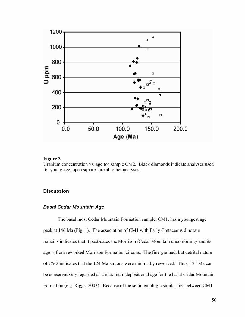
Figure 3. Uranium concentration vs. age for sample CM2. Black diamonds indicate analyses used for young age; open squares are all other analyses.
Discussion
Basal Cedar Mountain Age
The basal most Cedar Mountain Formation sample, CM1, has a youngest age
peak at 146 Ma (Fig. 1). The association of CM1 with Early Cretaceous dinosaur
remains indicates that it post-dates the Morrison /Cedar Mountain unconformity and its
age is from reworked Morrison Formation zircons. The fine-grained, but detrital nature
of CM2 indicates that the 124 Ma zircons were minimally reworked. Thus, 124 Ma can
be conservatively regarded as a maximum depositional age for the basal Cedar Mountain
Formation (e.g. Riggs, 2003). Because of the sedimentologic similarities between CM1
50
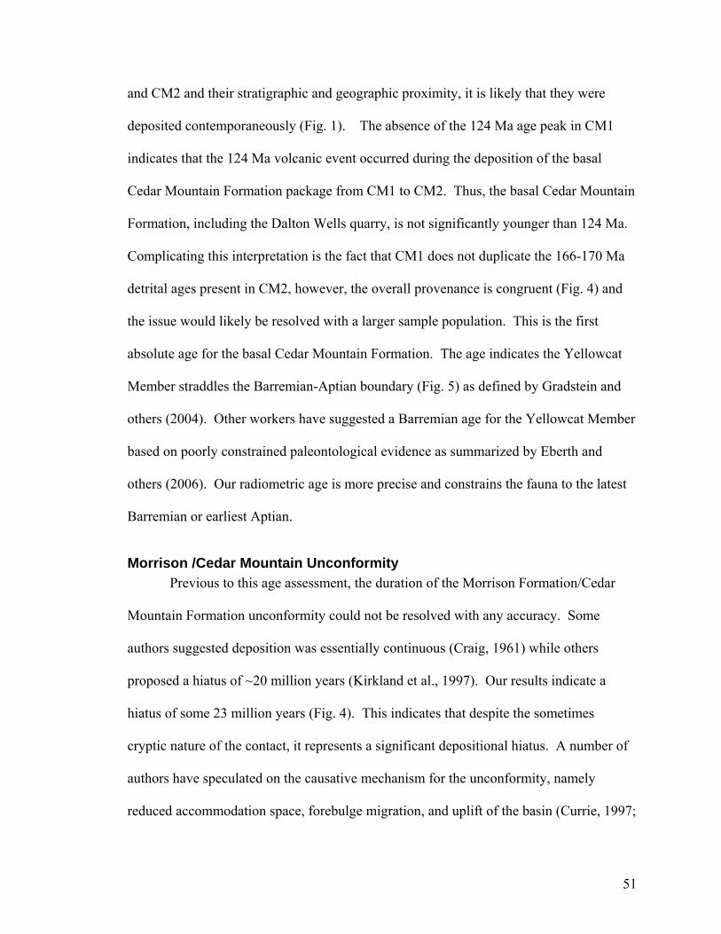
and CM2 and their stratigraphic and geographic proximity, it is likely that they were
deposited contemporaneously (Fig. 1). The absence of the 124 Ma age peak in CM1
indicates that the 124 Ma volcanic event occurred during the deposition of the basal
Cedar Mountain Formation package from CM1 to CM2. Thus, the basal Cedar Mountain
Formation, including the Dalton Wells quarry, is not significantly younger than 124 Ma.
Complicating this interpretation is the fact that CM1 does not duplicate the 166-170 Ma
detrital ages present in CM2, however, the overall provenance is congruent (Fig. 4) and
the issue would likely be resolved with a larger sample population. This is the first
absolute age for the basal Cedar Mountain Formation. The age indicates the Yellowcat
Member straddles the Barremian-Aptian boundary (Fig. 5) as defined by Gradstein and
others (2004). Other workers have suggested a Barremian age for the Yellowcat Member
based on poorly constrained paleontological evidence as summarized by Eberth and
others (2006). Our radiometric age is more precise and constrains the fauna to the latest
Barremian or earliest Aptian.
Morrison /Cedar Mountain Unconformity Previous to this age assessment, the duration of the Morrison Formation/Cedar
Mountain Formation unconformity could not be resolved with any accuracy. Some
authors suggested deposition was essentially continuous (Craig, 1961) while others
proposed a hiatus of ~20 million years (Kirkland et al., 1997). Our results indicate a
hiatus of some 23 million years (Fig. 4). This indicates that despite the sometimes
cryptic nature of the contact, it represents a significant depositional hiatus. A number of
authors have speculated on the causative mechanism for the unconformity, namely
reduced accommodation space, forebulge migration, and uplift of the basin (Currie, 1997;
51
Currie, 1998; Demko, Currie and Nicoll, 2004). This age control for the basal Cedar
Mountain Formation shows that the unconformity developed during the relatively quiet
period of time in the Sierran magmatic arc, from ~145-125 Ma (Christiansen et al., 1994).
Tectonically, this period involved mega thrust sheet emplacement concentrated in the
eastern portions of the Sevier thrust belt in central Utah and along shear zones within the
magmatic arc (Wyld et al., 2001). Emplacement of these thrust sheets at the edge of the
Cedar Mountain basin may have contributed to unconformity development. Additionally,
our data show that no sedimentary rocks were preserved in this area between 145 Ma and
125 Ma, which supports the conclusion of Christiansen and others (1994) that
sedimentary rocks were not well represented during periods of magmatic quiescence in
the western interior of North America. Christiansen and others (1994) speculated that
increased seafloor spreading rates may have inhibited magmatism in the arc and uplifted
the continental margins, which would lead to development of unconformities. This
explains the lack of volcanism during this time and fits the hypothesis that uplift of the
basin resulted in the development of the Morrison/Cedar Mountain unconformity (Currie,
1998). After 125 Ma, magmatism increased in the Sierran magmatic arc and had a
distribution similar to the Late Jurassic (Christiansen et al., 1994). The basal Cedar
Mountain age occurs at the beginning of this magmatic flare up and supports the link
between volcanism and sediment preservation in the western North American interior.
Intraformational Unconformities Current age controls indicate that the Cedar Mountain Formation covers about 26
Myr (Fig. 5). This is a large amount of time for a single terrestrial lithosome, considering
that the duration of similar formations is usually less than eight Myr (Eberth and
52
Hamblin, 1993; Kowallis et al., 1998; Ryan et al., 2001; Roberts et al., 2004). For
example, the Morrison Formation was deposited over a period of approximately 8 Myr
(Kowallis et al., 1998) with an average thickness of 200 m (Currie, 1997), giving an
average sedimentation rate of 2.5 cm/kyr. The Cedar Mountain Formation, in contrast,
has an average thickness of 40 meters (Currie, 1997) and was deposited over ~26 Myr,
giving an average sedimentation rate of 1.5 mm/kyr. With the long duration of the Cedar
Mountain Formation, an order of magnitude difference in sedimentation rate and the
presence of multiple vertebrate faunas (Kirkland et al., 1999; Eberth et al., 2006) it is
likely that significant intraformational unconformities exist. Geochronological studies
through the entire Cedar Mountain Formation are necessary to address this issue and
constrain the geochronology of the rest of this paleontologically rich package.
Faunal Correlations The Cedar Mountain Formation, and in particular the Yellowcat Member, were
deposited during a critical, but poorly represented period of North American dinosaur
evolution when the sauropod-dominated Late Jurassic fauna of the Morrison Formation
shifted to the ornithischian-dominated faunas of the Late Cretaceous. The Yellowcat
fauna is sauropod dominated, with a diverse fauna of over 11 dinosaurian genera,
including the most primitive therizinosaurid theropod, Falcarius utahensis; the giant
dromaeosaurid theropod, Utahraptor; four sauropods – an unnamed basal macronarian,
one or two brachiosaurids, and a camarasaurid; plus several iguanodontid ornithopods
and Gastonia, an ankylosaurid (Kirkland et al., 1997; Kirkland, 2005; Eberth et al.,
2006;). The therizinosaur (Kirkland, 2005) and basal macronarian (personal comm.
Brooks Britt) represent clades that are otherwise non-North American, facts that when
53
combined with a 124 Ma age make the taxa expecially significant in terms of
paleobiogeography and times of origin. It is informative that after a hiatus of some 23
Myr following Morrison times the camarasaurid and brachiosaurid clades survived, while
the most diverse Morrison sauropod clade, the Diplodocidae, went extinct in North
America (Upchurch et al., 2004). With absolute ages in hand, it is finally possible to
temporally compare the Yellowcat fauna to other well known Early Cretaceous faunas
(Table 2). There are only two age equivalent faunas, both from members at the base of
the Yixian Fm, of Liaoning, China, which are famous for superbly preserved early
angiosperms, insects, birds, feathered dinosaurs, and early mammals (Zhou et al., 2003).
Figure 4. Detrital zircon populations for both Cedar Mountain samples. Source terrains for both samples were dominantly Mesozoic strata of the Colorado Plateau.
54
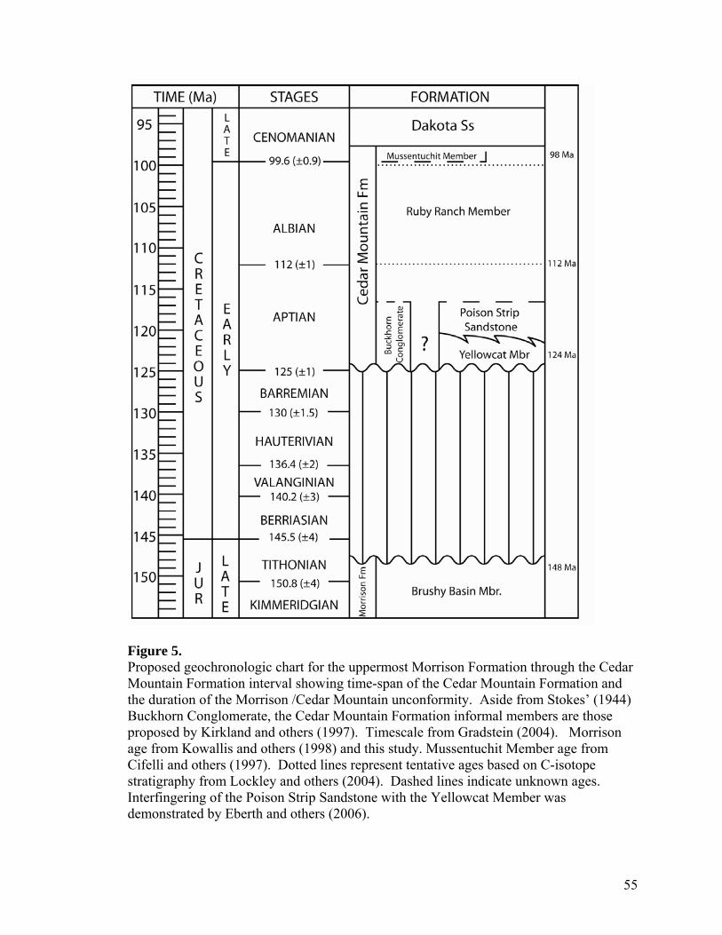
Figure 5. Proposed geochronologic chart for the uppermost Morrison Formation through the Cedar Mountain Formation interval showing time-span of the Cedar Mountain Formation and the duration of the Morrison /Cedar Mountain unconformity. Aside from Stokes’ (1944) Buckhorn Conglomerate, the Cedar Mountain Formation informal members are those proposed by Kirkland and others (1997). Timescale from Gradstein (2004). Morrison age from Kowallis and others (1998) and this study. Mussentuchit Member age from Cifelli and others (1997). Dotted lines represent tentative ages based on C-isotope stratigraphy from Lockley and others (2004). Dashed lines indicate unknown ages. Interfingering of the Poison Strip Sandstone with the Yellowcat Member was demonstrated by Eberth and others (2006).
55
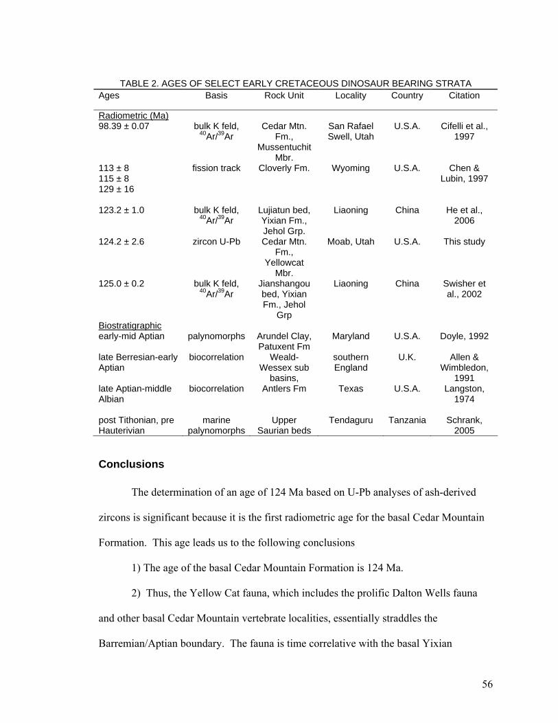
TABLE 2. AGES OF SELECT EARLY CRETACEOUS DINOSAUR BEARING STRATA
Ages Basis Rock Unit Locality Country Citation
Radiometric (Ma) 98.39 ± 0.07 bulk K feld,
40Ar/39Ar Cedar Mtn.
Fm., Mussentuchit
Mbr.
San Rafael Swell, Utah
U.S.A. Cifelli et al., 1997
113 ± 8 115 ± 8 129 ± 16
fission track Cloverly Fm. Wyoming U.S.A. Chen & Lubin, 1997
123.2 ± 1.0
bulk K feld,
40Ar/39Ar
Lujiatun bed, Yixian Fm., Jehol Grp.
Liaoning
China
He et al.,
2006
124.2 ± 2.6 zircon U-Pb Cedar Mtn. Fm.,
Yellowcat Mbr.
Moab, Utah U.S.A. This study
125.0 ± 0.2 bulk K feld, 40Ar/39Ar
Jianshangou bed, Yixian Fm., Jehol
Grp
Liaoning China Swisher et al., 2002
Biostratigraphic early-mid Aptian palynomorphs Arundel Clay,
Patuxent Fm Maryland U.S.A. Doyle, 1992
late Berresian-early Aptian
biocorrelation Weald-Wessex sub
basins,
southern England
U.K. Allen & Wimbledon,
1991 late Aptian-middle Albian
biocorrelation Antlers Fm Texas U.S.A. Langston, 1974
post Tithonian, pre Hauterivian
marine
palynomorphs
Upper
Saurian beds
Tendaguru
Tanzania
Schrank,
2005 Table
Conclusions
The determination of an age of 124 Ma based on U-Pb analyses of ash-derived
zircons is significant because it is the first radiometric age for the basal Cedar Mountain
Formation. This age leads us to the following conclusions
1) The age of the basal Cedar Mountain Formation is 124 Ma.
2) Thus, the Yellow Cat fauna, which includes the prolific Dalton Wells fauna
and other basal Cedar Mountain vertebrate localities, essentially straddles the
Barremian/Aptian boundary. The fauna is time correlative with the basal Yixian
56
Formation of China, which is well known for its exceptionally well-preserved flora and
fauna.
3) The duration of the Morrison /Cedar Mountain unconformity is ~23 Myr and is
significant because it occurs during a period of tectonic and magmatic quiescence in
western North America.
4) The Cedar Mountain Formation was deposited over ~26 Myr. The long
duration of this formation compared to other fluvial successions suggests that the Cedar
Mountain sedimentation rate was very slow and that the Cedar Mountain Formation may
contain other significant unconformities.
The close correlation of our zircon 206Pb/238U ages with previously obtained
sanidine 40Ar/39Ar ages demonstrates the reliability and utility of zircon ages, particularly
in sedimentary units where the abundance of ash and/or the preservation of feldspar is
low. Future applications of this technique for the Cedar Mountain Formation include
obtaining ages for other dinosaur bearing horizons, constraining the duration of the Cedar
Mountain Formation as a whole, and addressing the possibility and magnitude of
intraformational unconformities.
Acknowledgements Analytical work for this research was funded by National Science Foundation
grant EAR 0443387 to George Gehrels and by research funds provided to the authors
from Brigham Young University. Special thanks to George Gehrels, the University of
Arizona LaserChron staff and Sam Sorber for help with analytical work and data
reduction.
57
References
Allen, P., and Wimbledon, W.A., 1991, Correlation of NW European Purbeck-Wealden (nonmarine Lower Cretaceous) as seen from the English type-areas: Cretaceous Research, v. 12, p. 511-526.
Bateman, P.C., 1992, Plutonism in the central part of the Sierra Nevada Batholith, California: U.S.Geological Survey Professional Paper 1483, 186 p.
Camilleri, P., Yonkee, A., Coogan, J., DeCelles, P., McGrew, A., and Wells, M., 1997, Hinterland to foreland transect through the Sevier Orogen, northeast Nevada to north central Utah; structural style, metamorphism, and kinematic history of a large contractional orogenic wedge; Proterozoic to recent stratigraphy, tectonics, and volcanology, Utah, Nevada, southern Idaho and central Mexico: Geology Studies, v. 42, Part 1, p. 297-309.
Chen, Z., and Lubin, S., 1997, A fission-track study of the terrigenous sedimentary sequences of the Morrison and Cloverly formations in the northeastern Bighorn Basin, Wyoming: The Mountain Geologist, v. 34, p. 51-62.
Christiansen, E.H., Kowallis, B.J., and Barton, M.D., 1994, Temporal and spatial distribution of volcanic ash in Mesozoic sedimentary rocks of the western interior: an alternative record of Mesozoic magmatism, in Caputo, M.V., Peterson, J.A. and Franczyk, K.J., eds., Mesozoic systems of the Rocky Mountain Region, USA: Rocky Mountain Section, Society of Economic Paleontologists and Mineralogists, Special Publication, p. 73-93.
Cifelli, R.L., Kirkland, J.I., Weil, A., Deino, A.L., and Kowallis, B.J., 1997, High-precision Ar-40/Ar-39 geochronology and the advent of North America's Late Cretaceous terrestrial fauna: Proceedings of the National Academy of Sciences of the United States of America, v. 94, p. 11163-11167.
Craig, L.C., 1961, Discussion of 'Dakota Group of Colorado Plateau,', by Young R.G.: American Association of Petroleum Geologists Bulletin, v. 45, p. 1582-1584.
Currie, B.S., 1998, Upper Jurassic-Lower Cretaceous Morrison and Cedar Mountain formations, NE Utah-NW Colorado; relationships between nonmarine deposition and early Cordilleran foreland-basin development: Journal of Sedimentary Research, v. 68, p. 632-652.
Currie, B.S., 1997, Sequence stratigraphy of nonmarine Jurassic-Cretaceous rocks, central Cordilleran foreland-basin system: Geological Society of America Bulletin, v. 109, p. 1206-1222.
58
DeCelles, P.G., 2004, Late Jurassic to Eocene evolution of the Cordilleran thrust belt and foreland basin system, western U.S.A: American Journal of Science, v. 304, p. 105-168.
Demko, T.M., Currie, B.S., and Nicoll, K.A., 2004, Regional paleoclimatic and stratigraphic implications of paleosols and fluvial/overbank architecture in the Morrison Formation (Upper Jurassic), Western Interior, USA: Sedimentary Geology, v. 167, p. 115-135.
Doelling, H.H., 2001, Geologic map of the Moab and eastern part of the San Rafael Desert 30' X 60' quadrangles, Grand and Emory Counties, Utah and Mesa County, Colorado.
Doyle, J.A., Pons, D., and Broutin, J., 1992, Cladistic perspectives on the pre-Cretaceous history of angiosperms; Organisation internationale de Paleobotanique; IVeme conference; resumes des communications. International Paleobotanical Organization; fourth conference; abstracts: O.F.P.Informations, v. 16-B, p. 54.
Eberth, D.A., Britt, B.B., Scheetz, R.D., Stadtman, K.L., and Brinkman, D.B., 2006, Dalton Wells: Geology and significance of debris-flow-hosted dinosaur bonebeds (Cedar Mountain Formation, eastern Utah, USA): Palaeogeography, Palaeoclimatology, Palaeoecology, .
Eberth, D.A., and Hamblin, A.P., 1993, Tectonic, stratigraphic, and sedimentologic significance of a regional discontinuity in the upper Judith River Group (Belly River wedge) of southern Alberta, Saskatchewan, and northern Montana: Canadian Journal of Earth Sciences = Journal Canadien Des Sciences De La Terre, v. 30, p. 174-200.
Emmons, S.F., Eldridge, G.H., and Cross, C.W., 1896, Geology of the Denver Basin in Colorado: Monograph - U.S.Geological Survey.
Gradstein, F.M., 2004, A new geologic time scale, with special reference to Precambrian and Neogene: Episodes, v. 27, p. 83.
Kirkland, J.I., Zanno, L.E., Sampson, S.D., Clark, J.M., and DeBlieux, D.D., 2005, A primitive therizinosauroid dinosaur from the Early Cretaceous of Utah: Nature, v. 435, p. 84-87.
Kirkland, J.I., Britt, B.B., Burge, D.L., Carpenter, K., Cifelli, R.L., DeCourten, F.L., Eaton, J., Hasiotis, S., and Lawton, T., 1997, Lower to Middle Cretaceous dinosaur faunas of the central Colorado Plateau; a key to understanding 35 million years of tectonics, sedimentology, evolution and biogeography: Geology Studies, v. 42, Part 2, p. 69-103.
Kirkland, J.I., Burge, D., Britt, B.B., and Blows, W., 1993, The earliest Cretaceous (Barremian ?) dinosaur fauna found to date on the Colorado Plateau; Society of
59
Vertebrate Paleontology, 53rd annual meeting: Journal of Vertebrate Paleontology, v. 13, p. 45.
Kirkland, J.I., Cifelli, R.L., Britt, B.B., Burge, D.L., DeCourten, F.L., Eaton, J.G., Parrish, J.M., Cifelli, R.L., Britt, B.B., Burge, D.L., DeCourten, F.L., Eaton, J.G., and Parrish, J.M., 1999, Distribution of vertebrate faunas in the Cedar Mountain Formation, east-central Utah: Miscellaneous Publication - Utah Geological Survey, v. 99-1, p. 201-217.
Kowallis, B.J., Christiansen, E.H., Deino, A.L., Peterson, F., Turner, C.E., Kunk, M.J., and Obradovich, J.D., 1998, The Age of the Morrison Formation: Modern Geology, v. 22, p. 235-260.
Langston, W., 1974, Nonmammalian Comanchean tetrapods: Geoscience and Man, v. 8, Aspects of Trinity Division geology, p. 77-102.
Lockley, M.G., White, D., Kirkland, J., and Santucci, V., 2004, Dinosaur Tracks from the Cedar Mountain Formation (Lower Cretaceous), Arches National Park, Utah: Ichnos, v. 11, p. 285-293.
Ludwig, K.R., 2003, Isoplot 3.00. Berkeley Geochronology Center, Special Publication 4, 70 p.
Mitra, G., 1996, Evolution of salients in a fold-and-thrust belt; the effects of sedimentary basin geometry, deformation patterns and critical taper; Geological Society of America, 28th annual meeting: Abstracts with Programs - Geological Society of America, v. 28, p. 241-242.
Riggs, N.R., Ash, S.R., Barth, A.P., Gehrels, G.E., and Wooden, J.L., 2003, Isotopic age of the Black Forest Bed, Petrified Forest Member, Chinle Formation, Arizona; an example of dating a continental sandstone: Geological Society of America Bulletin, v. 115, p. 1315-1323.
Roberts, E., and Deino, A., 2004, Numerical age of the richly fossiliferous Kaiparowits Formation (Utah) and correlation of coeval (Judithian) vertebrate-bearing strata across the Western Interior Basin; Sixty-fourth annual meeting, Society of Vertebrate Paleontology; abstracts: Journal of Vertebrate Paleontology, v. 24, p. 104.
Royse, F., 1993, Case of the phantom foredeep; Early Cretaceous in west-central Utah: Geology (Boulder), v. 21, p. 133-136.
Ryan, M.J., Russell, A.P., Eberth, D.A., and Currie, P.J., 2001, The taphonomy of a Centrosaurus (Ornithischia, Certopsidae) bone bed from the Dinosaur Park Formation (upper Campanian), Alberta, Canada, with comments on cranial ontogeny: Palaios, v. 16, p. 482-506.
60
Schrank, E., 2005, Dinoflagellate cysts and associated aquatic palynomorphs from the Tendaguru Beds (Upper Jurassic-Lower Cretaceous) of southeast Tanzania: Palynology, v. 29, p. 49-85.
Stokes, W.L., 1944, Morrison formation and related deposits in and adjacent to the Colorado Plateau: Geological Society of America Bulletin, v. 55, p. 951-992.
Swisher, C.C., Wang X., Zhou Z., Wang Y., Jin F., Zhang J., Xu X., Zhang F., and Wang Y., 2002, Further support for a Cretaceous age for the feathered-dinosaur beds of Liaoning, China; new 40Ar/ 39Ar dating of the Yixian and Tuchengzi formations: Chinese Science Bulletin, v. 47, p. 135-138.
Trujillo, K.C., 2003, Stratigraphy and correlation of the Morrison Formation (Late Jurassic-?Early Cretaceous) of the Western Interior, U.S.A., with emphasis on southeastern Wyoming [Ph.D. thesis]: United States (USA), University of Wyoming, Laramie, WY, United States (USA), 192 p.
Tschudy, R.H., Tschudy, B.D., and Craig, L.C., 1984, Palynological evaluation of Cedar Mountain and Burro Canyon formations, Colorado Plateau: U.S.Geological Survey Professional Paper 1281, 24 p.
Upchurch, P., Barrett, P.M., and Dodson, P., 2004, Sauropoda, in Weishampel, D.B., Dodson, P. and Osmolska, H., eds., The Dinosauria: United States (USA), University of California Press, Los Angeles, CA, United States (USA), p. 259-322.
Winslow, N.S., and Heller, P.L., 1987, Evaluation of unconformities in Upper Jurassic and Lower Cretaceous nonmarine deposits, Bighorn Basin, Wyoming and Montana, U.S.A: Sedimentary Geology, v. 53, p. 181-202.
Yonkee, W.A., 1997, Kinematics and mechanics of the Willard thrust sheet, central part of the Sevier orogenic wedge, north-central Utah; Proterozoic to recent stratigraphy, tectonics, and volcanology, Utah, Nevada, southern Idaho and central Mexico: Geology Studies, v. 42, Part 1, p. 341-354.
Wyld, S.J., and Wright, J.E., 2001, New evidence for Cretaceous strike-slip faulting in the United States Cordillera and implications for terrane-displacement, deformation patterns, and plutonism: American Journal of Science, v. 301, p. 150-181.
Young, R.G., 1960, Dakota Group of Colorado Plateau: Bulletin of the American Association of Petroleum Geologists, v. 44, p. 156-194.
Zhou, Z., Barrett, P.M., and Hilton, J., 2003, An exceptionally preserved Lower Cretaceous ecosystem: Nature, v. 421, p. 807-814.
61