Embed Size (px)
Citation preview

A step towards procedural terrain generation with GANs
Christopher Beckham 1 Christopher Pal 1
AbstractProcedural terrain generation for video gameshas been traditionally been done with smartly de-signed but handcrafted algorithms that generateheightmaps. We propose a first step toward thelearning and synthesis of these using recent ad-vances in deep generative modelling with openlyavailable satellite imagery from NASA.
1. IntroductionProcedural generation in video games is the algorithmicgeneration of content intended to increase replay valuethrough interleaving the gameplay with elements of unpre-dictability. This is in contrast to the more traditional, ‘hand-crafty’ generation of content, which is generally of higherquality but with the added expense of labour. A prominentgame whose premise is almost entirely based on procedu-ral terrain generation is Minecraft, a game where the playercan explore a vast open world whose terrain is based en-tirely on voxels (‘volumetric pixels’), allowing the player tomanipulate the terrain (i.e. dig tunnels, build walls) and ex-plore interesting landscapes (i.e. beaches, jungles, caves).
So far, terrains have been procedurally generated througha host of algorithms designed to mimic real-life terrain.Some prominent examples of this include Perlin noise (Per-lin, 1985) and diamond square (Fournier et al., 1982), inwhich a greyscale image is generated from a noise source(with intensities proportional to heights above sea level),which, when rendered in 3D as a mesh, produces a terrain.While these methods are quite fast, they generate terrainswhich are quite simple in nature. Software such as L3DTemploy sophisticated algorithms which let the user controlwhat kind of terrain they desire, (e.g. mountains, lakes, val-leys), and while these can produce very impressive terrains1, it would still seem like an exciting endeavour to leveragethe power of generative networks in deep learning (such as
1Montreal Institute of Learning Algorithms, Quebec,Canada. Correspondence to: Christopher Beckham <[email protected]>.
Submitted to VGML workshop at ICML 2017.1See http://www.bundysoft.com/docs/doku.
php?id=l3dt:algorithms
the GAN (Goodfellow et al., 2014)) to learn algorithms toautomatically generate terrain, without the need to manu-ally write algorithms to do so.
In this paper, we leverage extremely high-resolution ter-rain and heightmap data provided by the NASA ‘VisibleEarth’ project2 in conjunction with generative adversarialnetworks (GANs) to create a two-stage pipeline in whichheightmaps can be randomly generated as well as a tex-ture map that is inferred from the heightmap. Concretely,we synthesise 512px height and texture maps using ran-dom 512px crops from the original NASA images (of size21600px x 10800px), as seen in Figure 1.
1.1. Formulation
Suppose z′ ∼ p(z) is a k-dimensional sample we drawfrom the prior distribution, x′ = Gh(z
′) the heightmapwhich is generated from z′, and y′ = Gt(x
′) is the tex-ture generated from the corresponding heightmap. We canthink of this process as being comprised of two GANs:the ‘DCGAN’ (Radford et al., 2015) which generates theheightmap from noise, and ‘pix2pix’ (Isola et al., 2016),which (informally) refers to conditional GANs for image-to-image translation. If we denote the DCGAN generatorand discriminator as Gh(·) and Dh(·) respectively (wherethe ‘h’ in the subscript denotes ‘heightmap’), then we canformulate the training objective as:
minGh
`(Dh(Gh(z′)), 1)
minDh
`(Dh(x), 1) + `(Dh(Gh(z′)), 0),
(1)
where ` is a GAN-specific loss, e.g. binary cross-entropyfor the regular GAN formulation, and squared error for LS-GAN (Mao et al., 2016). We can write similar equations forthe pix2pix GAN, where we now have Gt(·) and Dt(·, ·)instead (where ‘t’ denotes ‘texture’), and instead of x andx′ we have y (ground truth texture) and y′ (generated tex-ture), respectively. Note that the discriminator in this case,Dt, actually takes two arguments: either a real heightmap/ real texture pair (x,y), or a real heightmap / generatedtexture pair (x,y′). Also note that for the pix2pix part ofthe network, we can also employ some form of pixel-wisereconstruction loss to prevent the generator from dropping
2https://visibleearth.nasa.gov/
arX
iv:1
707.
0338
3v1
[st
at.M
L]
11
Jul 2
017

A step towards procedural terrain generation with GANs
(a) World heightmap (b) World texture map
Figure 1. Heightmap and texture map (21600px x 10800px) of the earth provided by the NASA Visible Earth project. Both maps providea spatial resolution of 1 square km per pixel.
modes. Therefore, we can write the training objectives forpix2pix as such:
minGt
`(Dt(x, Gt(x′)), 1) + λd(y, Gt(x
′))
minDt
`(Dt(x,y), 1) + `(Dt(x, Gt(x′)), 0),
(2)
where d(·, ·) can be some distance function such as L1 orL2 loss, and λ is a hyperparameter denoting the relativestrength of the reconstruction loss. We set λ = 100 and useL1.
2. Experiments and ResultsAs a first step, we train a DCGAN which maps samplesfrom the prior z′ ∼ p(z) to a generated heightmap x′ =Gh(z
′) of size 512px. While we experienced some issueswith training stability we were able to generate heightmapsthat were somewhat faithful to the original images. Wegenerate two of these and illustrate a linear interpolationbetween the two, which is shown in Figure 2. While theinterpolation is shown purely for illustrative purposes, onecould imagine that if the DCGAN successfully learned rep-resentations of the different landscapes (e.g. mountains,valleys, desert, jungle) then one could find their latent rep-resentations – through a bidirectional GAN like BiGAN(Donahue et al., 2016) or ALI (Dumoulin et al., 2016) –then interpolate between them and decode to control theresulting heightmap.
Apart from the aforementioned stability issues, the gener-ated heightmaps can sometimes exhibit small-scaled arti-facts, which can be seen for the first generated heightmap(top-left corner). While experimenting with deeper archi-tectures and/or skip connections could mitigate this, oneeasy trick is to apply a slight blur to the final images via aGaussian kernel convolution. This can serve to smooth outany weird artifacts generated by the DCGAN.
Figure 3 shows the a variety of heightmaps generated withthe DCGAN Gh and their corresponding translations to
textures by the pix2pix GAN Gt. We can see that thepix2pix GAN has created textures that roughly ‘match’their corresponding heightmaps. For example, regions ofrelatively higher elevation in the heightmap correspond todifferent textures. Interestingly, parts of some of the tex-tures are completely white; this appears to be a side-effectof not training the DCGAN and pix2pix GANs jointly.
3. ConclusionIn this work we have achieved a reasonable first step towardprocedural generation of terrain based on real-world data.The most obvious next step would be to jointly train theDCGAN and pix2pix GANs.
A neat addition to this idea would be the addition of a seg-mentation pipeline to classify different parts of the terrain,e.g. biomes. This effectively serves as a layer of metadatathat can be leveraged to add interesting detail in the terrain.For example, if the segmentation identifies a certain regionin the generated terrain as ‘jungle’, the 3D game engine (orrenderer) can automatically populate that region with treesand plants. (This is called a ‘splatmap’ in the computergraphics literature.)
The two-stage GAN framework that we have describedhere can have many applications in procedural generationoutside of terrain modelling. For example, one can imag-ine the same scheme being applied to synthesise 3D mesheswhich are then textured (e.g. faces). These kinds of possi-bilities serve to not only promote richer entertainment ex-periences, but to also provide useful tools to aid contentproducers (e.g. 3D artists) in their work.
4. AcknowledgementsThe authors would like to thank the developers of Theano(Theano Development Team, 2016), Lasagne (Dielemanet al., 2015), and Keras (Chollet et al., 2015). This workis partially funded by Imagia, Inc. under a MITACS Accel-erate scholarship.

A step towards procedural terrain generation with GANs
Figure 2. A linear interpolation of two heightmaps (top-left and bottom-right corner).
Figure 3. Heightmaps generated by the Gh and their corresponding textures predicted by Gt. The texture GAN Gt seems to think thathigh elevations are snow, despite the fact that we are generating deserts – what is this madness?! We will just pretend they are salt flatsfor now.
A step towards procedural terrain generation with GANs
(a) Heightmap (b) Texture map
Figure 4. Left: randomly generated heightmap, right: the corresponding texture. Both images are 512px, which corresponds to 512square km.
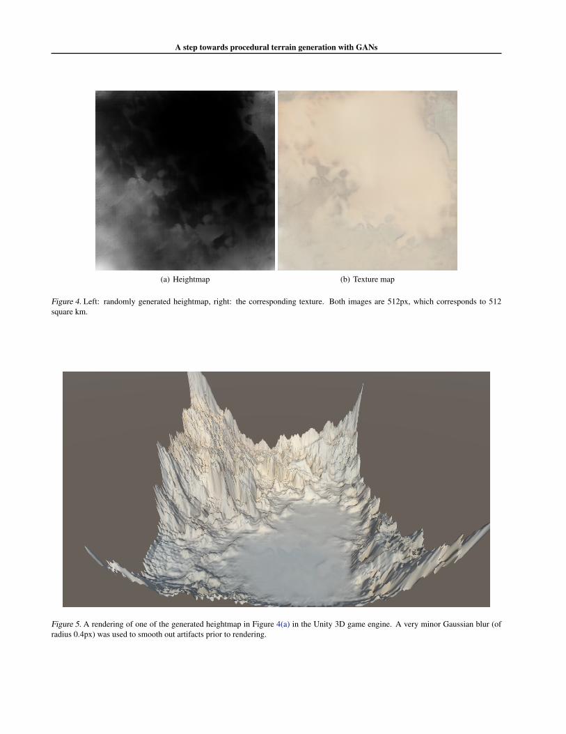
Figure 5. A rendering of one of the generated heightmap in Figure 4(a) in the Unity 3D game engine. A very minor Gaussian blur (ofradius 0.4px) was used to smooth out artifacts prior to rendering.

A step towards procedural terrain generation with GANs
ReferencesChollet, Francois et al. Keras. https://github.com/fchollet/keras, 2015.
Dieleman, Sander, Schlter, Jan, Raffel, Colin, Olson, Eben,Snderby, Sren Kaae, Nouri, Daniel, and et al. Lasagne:First release., August 2015. URL http://dx.doi.org/10.5281/zenodo.27878.
Donahue, Jeff, Krahenbuhl, Philipp, and Darrell, Trevor.Adversarial feature learning. CoRR, abs/1605.09782,2016. URL http://arxiv.org/abs/1605.09782.
Dumoulin, Vincent, Belghazi, Ishmael, Poole, Ben, Lamb,Alex, Arjovsky, Martin, Mastropietro, Olivier, andCourville, Aaron. Adversarially learned inference. arXivpreprint arXiv:1606.00704, 2016.
Fournier, Alain, Fussell, Don, and Carpenter, Loren. Com-puter rendering of stochastic models. Commun. ACM,25(6):371–384, June 1982. ISSN 0001-0782. doi:10.1145/358523.358553. URL http://doi.acm.org/10.1145/358523.358553.
Goodfellow, Ian, Pouget-Abadie, Jean, Mirza, Mehdi, Xu,Bing, Warde-Farley, David, Ozair, Sherjil, Courville,Aaron, and Bengio, Yoshua. Generative adversarial nets.In Advances in neural information processing systems,pp. 2672–2680, 2014.
Isola, Phillip, Zhu, Jun-Yan, Zhou, Tinghui, and Efros,Alexei A. Image-to-image translation with conditionaladversarial networks. CoRR, abs/1611.07004, 2016.URL http://arxiv.org/abs/1611.07004.
Mao, Xudong, Li, Qing, Xie, Haoran, Lau, RaymondY. K., and Wang, Zhen. Multi-class generative ad-versarial networks with the L2 loss function. CoRR,abs/1611.04076, 2016. URL http://arxiv.org/abs/1611.04076.
Perlin, Ken. An image synthesizer. SIGGRAPH Com-put. Graph., 19(3):287–296, July 1985. ISSN 0097-8930. doi: 10.1145/325165.325247. URL http://doi.acm.org/10.1145/325165.325247.
Radford, Alec, Metz, Luke, and Chintala, Soumith.Unsupervised representation learning with deep con-volutional generative adversarial networks. CoRR,abs/1511.06434, 2015. URL http://arxiv.org/abs/1511.06434.
Theano Development Team. Theano: A Python frameworkfor fast computation of mathematical expressions. arXive-prints, abs/1605.02688, May 2016. URL http://arxiv.org/abs/1605.02688.
5. Supplementary materialIn this section we provide some extra information that wewere unable to fit into the main section due to page restric-tions.
5.1. Dataset
The dataset was prepared as follows. First, we downloadeda high-res heightmap and texture map of the earth, as can befound here3 and here4. We slide a 512px window throughboth images simultaneously, and only retain (heightmap,texture) pairs where the heightmap’s colour compositionis less than 90% black; this so that we do not feed theGAN data that is too ‘trivial’ to generate. Note that at thispoint, textures in the collection can correspond to variousbiomes such as jungle, desert, and arctic, and in theory,any particular heightmap could correspond to any of thesebiomes (which can confuse the pix2pix GAN during train-ing). To address this, we choose a ‘reference texture’ withour biome of interest (in our case, desert), and computethe Euclidean distance between this texture and all othertextures in the collection. From this, we choose the top Mpairs that have the smallest distances with the reference tex-ture, so that the final collection only contains pairs whosebiome of interest is desert.
5.2. Architectures
Images detailing the precise architectures used for theGANs have been added in the .zip file from which thesource of this LATEX can be found.
5.3. Training
We use the LSGAN formulation as this made training morestable. Therefore, the `(·, ·) in Equations 1 and 2 are binarycross-entropy, and the output activations of both discrimi-nators Dh and Dt are linear instead of sigmoid.
We train both GANs using RMSProp with initial learningrates 1e−4.
3https://eoimages.gsfc.nasa.gov/images/imagerecords/74000/74218/world.200412.3x21600x10800.jpg
4https://eoimages.gsfc.nasa.gov/images/imagerecords/73000/73934/gebco_08_rev_elev_21600x10800.png