Embed Size (px)
Citation preview

A spatial analysis approach to the global delineation of dryland areas of relevance to the CBD Programme of
Work on Dry and Subhumid Lands
Prepared by Levke Sörensen at the UNEP World Conservation Monitoring Centre
Cambridge, UK January 2007

This report was prepared at the United Nations Environment Programme World Conservation Monitoring Centre (UNEP-WCMC). The lead author is Levke Sörensen, scholar of the Carlo Schmid Programme of the German Academic Exchange Service (DAAD).

3
Acknowledgements This report benefited from major support from Peter Herkenrath, Lera Miles and Corinna
Ravilious. UNEP-WCMC is also grateful for the contributions of and discussions with
Jaime Webbe, Programme Officer, Dry and Subhumid Lands, at the CBD Secretariat.
Disclaimer The contents of the map presented here do not necessarily reflect the views or policies of
UNEP-WCMC or contributory organizations. The designations employed and the
presentations do not imply the expression of any opinion whatsoever on the part of
UNEP-WCMC or contributory organizations concerning the legal status of any country,
territory or area or its authority, or concerning the delimitation of its frontiers or
boundaries.

4
Table of contents Acknowledgements............................................................................................3
Disclaimer ...........................................................................................................3
List of tables, annexes and maps .....................................................................5
Abbreviations and acronyms ............................................................................7
Executive Summary ...........................................................................................8
1. Introduction.....................................................................................................9
1.1 Scope ................................................................................................................ 9
1.2 Aims and objectives ...................................................................................... 12
2. Methods.........................................................................................................13
2.1 Dataset choice and justification................................................................... 13
2.3 Biomes containing drylands......................................................................... 15
2.3 Spatial data analysis ..................................................................................... 17
3. Results ..........................................................................................................20
4. Conclusions..................................................................................................34
References........................................................................................................36
Annexes 1-6……………………………………………………………………..I - XXVI

5
List of tables, annexes and maps Table 1: Percentage of the biomes 7, 8, 10, 12 and 13 on the biogeographic realms
Table 2: Percentage of biomes in hyperarid, arid, semiarid and dry subhumid zones
Table 3: Percentage of the global terrestrial area, and of each biogeographic realm,
defined as dryland using different dryland definitions
Annex 1: Classification of ecoregions within biome 7 – Tropical and Subtropical
Grasslands, Savannahs and Shrublands
Annex 2: Classification of ecoregions within biome 8 – Temperate Grasslands,
Savannahs and Shrublands
Annex 3: Classification of ecoregions within biome 10 – Montane Grasslands and
Shrublands
Annex 4: Classification of ecoregions within biome 12 – Mediterranean Forests,
Woodlands and Scrub
Annex 5: Percentage of ecoregions within biome 13 (Deserts & xeric Shrublands) in
P/PET < 0.65
Annex 6: Explanations to Annex 1 - 5
Map 1: UNCCD delineation of drylands
Map 2: Extent of dryland systems according to the World Atlas of Desertification
Map 3: Biogeographic realms
Map 4: Extent of biomes 7, 8, 10, 12 and 13
Map 5: Extent of biomes 7, 8, 10, 12 and 13 with P/PET ratio ≥ 0.65
Map 6: Global delineation of areas in relation to the CBD PoW on Dry and Subhumid
Lands
Map 7: Delineation of areas in relation to the CBD PoW on Dry and Subhumid Lands,
Afrotropic I
Map 8: Delineation of areas in relation to the CBD PoW on Dry and Subhumid Lands,
Afrotropic II
Map 9: Delineation of areas in relation to the CBD PoW on Dry and Subhumid Lands,
Australasia
Map 10: Delineation of areas in relation to the CBD PoW on Dry and Subhumid Lands,
Indo-Malay

6
Map 11: Delineation of areas in relation to the CBD PoW on Dry and Subhumid Lands,
Nearctic
Map 12: Delineation of areas in relation to the CBD PoW on Dry and Subhumid Lands,
Neotropic
Map 13: Delineation of areas in relation to the CBD PoW on Dry and Subhumid Lands,
Palearctic I
Map 14: Delineation of areas in relation to the CBD PoW on Dry and Subhumid Lands,
Palearctic II

7
Abbreviations and acronyms AA Australasia
AHTEG Ad Hoc Technical Expert Group
AT Afrotropic
CBD Convention on Biological Diversity
COP Conference of the Parties
CRU/UEA Climatic Research Unit/University of East Anglia
ESRI Environmental Systems Research Institute
FAO Food and Agriculture Organization of the United Nations
FRA Forest Resources Assessment
GIS Geographic Information System
GRID Global Resource Information Database
IFFN International Forest Fire News
IM Indo-Malay
JWP Joint Work Programme
LADA Land Degradation Assessment in Drylands
NA Nearctic
NT Neotropic
OC Oceania
PA Palearctic
PoW Programme of Work
P/PET Ratio of mean annual precipitation (P) to mean annual potential
evapotranspiration (PET)
SBSTTA Subsidiary Body on Scientific, Technical and Technological Advice
UNCCD United Nations Convention to Combat Desertification
UNEP United Nations Environment Programme
UNEP-WCMC UNEP World Conservation Monitoring Centre
WRI World Resources Institute
WWF World Wildlife Fund/World Wide Fund for Nature
Executive Summary
8
Executive Summary The world’s drylands are affected by desertification and biodiversity loss, two closely
related pressures. In 2003, the Secretariats of the Convention on Biological Diversity
(CBD) and the United Nations Convention to Combat Desertification (UNCCD) therefore
agreed a Joint Work Programme (JWP), focusing on the biological diversity of dry and
sub-humid lands. This Programme is based, both in content and extent, on the thematic
Programme of Work (PoW) on Dry and Sub-humid Lands of the CBD.
A basic challenge for the implementation of the JWP is the divergence in definition of
drylands between the Conventions. While the UNCCD has a spatially explicit definition of
dryland boundaries, the CBD definition is both broader and less precise. The UNCCD
bioclimatic definition covers 34.9 percent of the world’s terrestrial area, whilst the CBD
bioclimatic definition covers a 41.5 percent. The CBD definition also includes additional
areas on the basis of their vegetation cover.
In order to identify areas of interest under the JWP, a global mapping effort is
indispensable. This study uses a GIS spatial analysis at a global scale to provisionally
delineate the areas that the CBD PoW, and hence also the JWP, encompasses. Maps of
the WWF terrestrial ecoregions (WWF-US 2004) and of aridity zones (CRU/UEA; UNEP-
GRID 1991) were used to identify areas included within the CBD definition. Using criteria
based on the CBD definition, the ecoregion descriptions were evaluated to classify areas
extending beyond the CBD bioclimatic definition as ‘presumed included’, or ‘presumed
excluded’, or ‘to review’. 44.6 percent of the area concerned was classed as ‘to review’ as
a result of uncertainty on the existence of dryland features. 1.3 percent was classified as
‘presumed excluded’, as dryland features are largely absent.
Depending on the precise dryland criteria used, the CBD PoW could cover 41.5 to 52.3
percent of the world’s terrestrial area, that is between 6.6 and 17.4 percent more than the
UNCCD definition. The delineation of dryland areas, and hence their extent, has major
implications for the scope of the PoW and the JWP.
This study reveals the need for an agreed global map of dryland areas, highlights some
issues in delineating dryland boundaries, and offers a provisional map for discussion.

Introduction
9
1. Introduction
1.1 Scope
Realizing the relationship between desertification and biodiversity loss, and between
sustainable livelihoods and the conservation and sustainable use of biodiversity
(Mulongoy and Zeidler 2003), the fifth Conference of the Parties to the Convention on
Biological Diversity (CBD) in 2000 adopted a Programme of Work on Dry and Sub-humid
Lands in order to fill knowledge gaps and promote conservation (Decision V/23). The
shared goals of the CBD and the United Nations Convention to Combat Desertification
(UNCCD) mean that joint implementation of and collaboration between the two
conventions can yield multiple benefits (Millennium Ecosystem Assessment 2005). The
Secretariats of the CBD and the UNCCD agreed on a Joint Work Programme (JWP) in
2003 (UNEP/CBD/COP/7/INF/28). The JWP follows the rationale and structure of the
CBD Programme of Work (PoW) and highlights areas of possible collaboration and joint
action. In this context, a definition of the global dryland extent is indispensable in order to
define the scope of activities within the JWP. As is detailed below, the two conventions
define drylands differently. As the JWP is based on the CBD PoW, the dryland definition
from this document is most relevant to the JWP.
1.1.1 UNCCD definition of drylands The UNCCD defines drylands according to an aridity index, calculated as the ratio of
mean annual precipitation (P) to mean annual potential evapotranspiration (PET).
The world is divided into six aridity zones: hyperarid, arid, semiarid, dry subhumid, humid
and cold climates (Middleton and Thomas 1992). UNCCD covers only arid, semi-arid and
dry subhumid areas (other than polar and sub-polar regions). The P/PET ratio within
these zones ranges from 0.05 to 0.65 (UNCCD 1994, Article 1). Together, the UNCCD
dryland zones cover approximately 34.9 percent of the Earth’s terrestrial surface (Map 1).

Introduction
10
Map 1: UNCCD delineation of drylands
Map 2: Extent of dryland systems according to the World Atlas of Desertification

Introduction
11
1.1.2 CBD definition of drylands The CBD definition of ‘drylands’ used within its Programme of Work on Dry and Sub-
humid Lands (UNEP/CBD/SBSTTA/5/9) differs from the UNCCD definition described
above in two ways:
i. It also includes hyperarid zones (UNEP/CBD/SBSTTA/5/9), which represent
approximately 6.6 percent of the Earth’s land surface. In including these desert regions
in the dryland definition, the CBD follows the World Atlas of Desertification (Map 2; see
Middleton and Thomas 1992). All areas with P/PET ratio less than 0.65 are therefore
included; this encompasses 41.5 % of the world’s terrestrial area.
ii. Major vegetation types are used to define dryland areas in addition to those defined
based on the bioclimatic criterion (P/PET ratio) (UNEP/CBD/SBSTTA/5/9). Hence, the
CBD PoW does not only apply to the biological diversity of drylands senso stricto, but
also includes Mediterranean, grassland and savannah ecosystems (Decision V/23).
These ecosystem types are present in some areas with P/PET ratio ≥ 0.65, including
humid and cold areas.
The CBD Subsidiary Body on Scientific, Technical and Technological Advice (SBSTTA)
and the Ad Hoc Technical Expert Group (AHTEG) on Dry and Subhumid Lands have
provided a generic description of Mediterranean, grassland and savannah ecosystems
(UNEP/CBD/SBSTTA/4/7):
Mediterranean ecosystems are loosely defined because no single climatic or bioclimatic
definition has yet been established. They generally include areas with cool, wet winters
and warm or hot dry summers. They encompass a wide range of habitat types (forest,
woodland, grassland) and are typified by a low, woody, fire-adapted sclerophyllous
shrubland.
Savannah ecosystems are dominated at the ground layer by grasses and grass-like
plants. They form a continuum from treeless plains through open woodlands to closed-
canopy woodlands with a grassy understorey.
Grassland ecosystems are loosely defined as areas dominated by grasses
(Graminaceae) or grass-like plants with few woody plants. Periodic drought, highly
seasonal rainfall, fire and grazing by large herbivores are typical characteristics of natural
grassland and savannah ecosystems.
Introduction
12
Apart from this generic description, the SBSTTA and AHTEG documents reviewed for
this study do not provide a detailed delineation of the areas covered by the PoW. Some
authors do mention specific geographic regions within these ecosystem types (LADA,
WRI 2004; UNEP/CBD/SBSTTA11/4/Add.1), but so far, no global mapping effort has
delineated their boundaries on behalf of the PoW. However, clearly defined boundaries
and georeferenced data are required in order to assess the status of dryland biodiversity,
e.g. through spatial analysis.
1.2 Aims and objectives
The JWP of the two conventions is modelled on the CBD PoW on Dry and Subhumid
Lands; however, neither the JWP nor the CBD PoW precisely defines the spatial scope.
Future activities regarding biological diversity in drylands that contain a spatial analysis
component require an agreed, explicit delineation of the areas included.
Therefore, this study aims to provisionally delineate the areas that the CBD PoW (hence
the JWP) encompasses. Its objective is to assess and emphasize the need for a distinct
delineation as a basis for further scientific research and policy analysis. The analysis
offers an approach to mapping drylands and a provisional map, rather than a definitive
delineation.
Further, we aim to identify the impact of alternative interpretations of the definition of
dryland area on the scope of the PoW.

Methods
13
2. Methods This study has provisionally defined and mapped the areas covered by the PoW.
2.1 Dataset choice and justification
The following two datasets capture important aspects of the CBD dryland definition:
First, the aridity zones dataset (CRU/UEA; UNEP-GRID 1991) delineates the areas
commonly defined as drylands: hyperarid, arid, semiarid and dry subhumid zones (P/PET
< 0.65) (Map 2).
Second, the WWF terrestrial ecoregions dataset (WWF-US 2004) has been chosen as an
appropriate tool to identify additional areas relevant to the PoW that fall outside this strict
definition. This dataset contains the spatial boundaries of 867 terrestrial ecoregions.
WWF defines ecoregions as ‘relatively large units of land containing a distinct
assemblage of natural communities and species, with boundaries that approximate the
original extent of natural communities prior to major land-use’. The terrestrial ecoregions
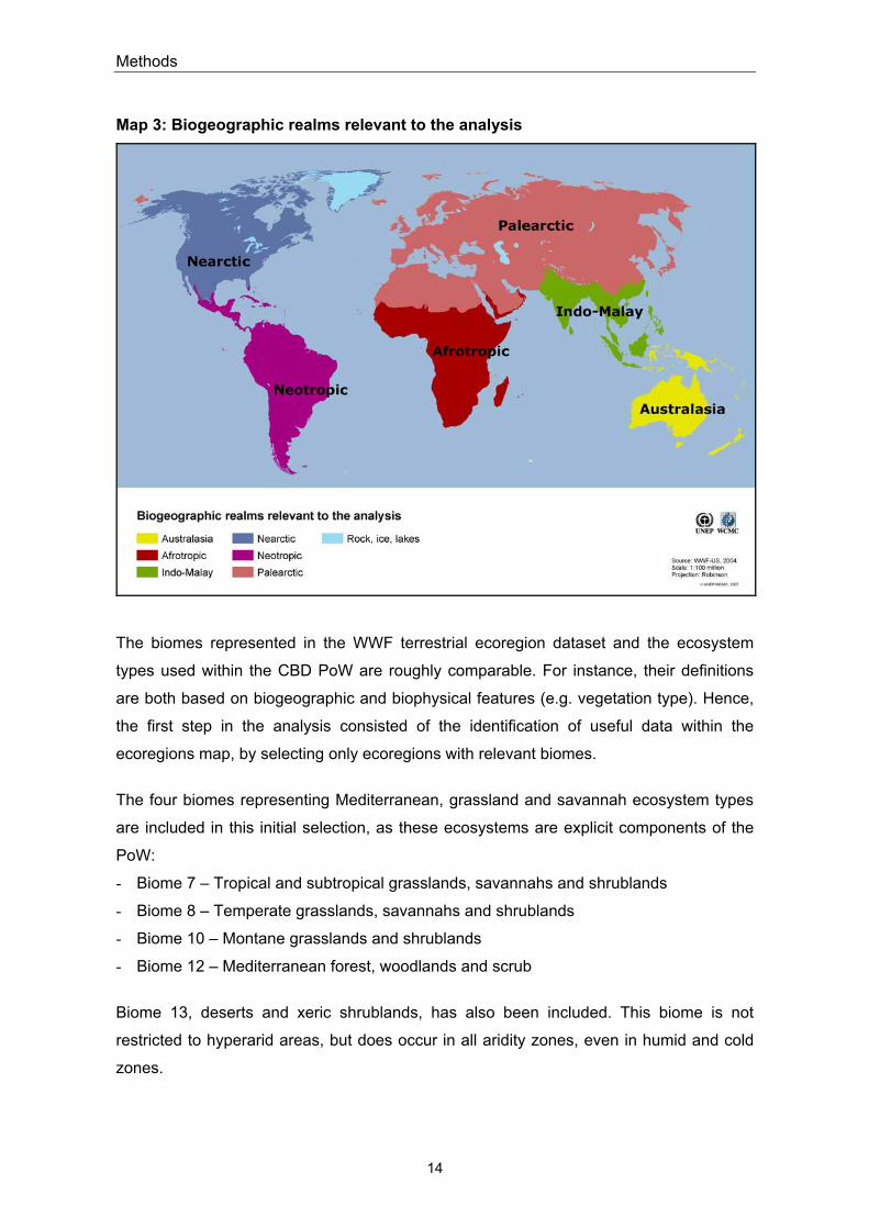
are nested within 14 biomes or ‘major habitat types’ (Olson et al. 2001). The dataset also
classifies the terrestrial surface into eight biogeographic realms: Antarctic, Australasia,
Afrotropic, Indo-Malay, Nearctic, Neotropic, Oceania and Palearctic (Map 3). A realm is
defined as ‘a continent or sub-continent-sized area with unifying features of geography
and fauna/flora/vegetation’ (Udvardy 1975).
The terrestrial ecoregions dataset was selected for several reasons:
(i) unlike present land cover maps, the ecoregions map indicates the original extent of
natural communities prior to major land-use change, thus the potential natural vegetation.
(ii) WWF provides detailed information about every ecoregion, which facilitates the
inclusion and exclusion of areas within the scope of the CBD PoW. Most land cover and
potential natural vegetation maps do not include a comparable set of associated
information.
(iii) The ecoregions map is more detailed in scale than the biome map.
Methods
14
Map 3: Biogeographic realms relevant to the analysis
The biomes represented in the WWF terrestrial ecoregion dataset and the ecosystem
types used within the CBD PoW are roughly comparable. For instance, their definitions
are both based on biogeographic and biophysical features (e.g. vegetation type). Hence,
the first step in the analysis consisted of the identification of useful data within the
ecoregions map, by selecting only ecoregions with relevant biomes.
The four biomes representing Mediterranean, grassland and savannah ecosystem types
are included in this initial selection, as these ecosystems are explicit components of the
PoW:
- Biome 7 – Tropical and subtropical grasslands, savannahs and shrublands
- Biome 8 – Temperate grasslands, savannahs and shrublands
- Biome 10 – Montane grasslands and shrublands
- Biome 12 – Mediterranean forest, woodlands and scrub
Biome 13, deserts and xeric shrublands, has also been included. This biome is not
restricted to hyperarid areas, but does occur in all aridity zones, even in humid and cold
zones.

Methods
15
Flooded grasslands and savannahs (biome 9) have been excluded because they contain
mainly wetland areas, which cannot be considered as part of the PoW. Furthermore,
many seasonally flooded areas are intermediary between grassland and inland water
ecosystems (UNEP/CBD/SBSTTA/4/7).
2.3 Biomes containing drylands
Biome 7 – Tropical and subtropical grasslands, savannahs and shrublands This biome does not receive enough rainfall to support extensive tree cover. Grasses
dominate the species composition. Scattered trees may be common. Large wild
herbivores and domestic livestock shape the habitat by grazing (WWF 2006). Almost 70
percent of this biome is located in the Afrotropical biogeographic realm, nearly 20 percent
in the Neotropic realm and 10.5 percent in Australasia (Table 1, Map 4).
Biome 8 – Temperate grasslands, savannahs and shrublands This biome is known as prairie in North America, pampas in South America, veld in
Southern Africa and steppe in Asia. It differs in annual temperature regime from biome 7
and is generally devoid of trees. However, some regions are characterized by
interspersed trees or riparian or gallery forests. As for biome 7, large grazing mammals
naturally occur here (WWF 2006). Over 46 percent of the biome’s extent can be found in
the Palearctic and nearly 31 percent in the Nearctic realm. 16 percent appear in the
Neotropic realm and 6 percent in Australasia. Very little is found in the Afrotropic realm
(Table 1, Map 4).
Biome 10 – Montane grasslands and shrublands This biome includes montane and alpine grasslands and shrublands, e.g. the puna and
páramo in South America, subalpine heathlands in New Guinea and East Africa and
steppes of the Tibetan plateaus (WWF 2006). Nearly two-thirds is located in the
Palearctic realm, 17 percent of the biome’s extent is found in both the Afrotropic and
Neotropic realms (Table 1, Map 4).
Biome 12 – Mediterranean forest, woodlands and scrub Only five regions in the world, spread across five different realms, experience
Mediterranean conditions: the Mediterranean basin, south-central and southwestern
Australia, the fynbos of southern Africa, the Chilean matorral and the Mediterranean
ecoregions of California. Mediterranean species are adapted to tolerate long, hot

Methods
16
summers with little precipitation. Most plants found in this biome are fire-adapted,
including species dependent on fire for their persistence (WWF 2006). The
Mediterranean Basin, in the Palearctic realm, represents approximately 64 percent of the
biome’s global extent. Another 25 percent is found in Australasia (Table 1, Map 4).
Table 1: Percentage of biomes 17, 8, 10, 12 and 13 in each biogeographic realm
Biome Realm percentage
7: Tropical and subtropical grasslands, savannahs and shrublands AA 10.96AT 69.04IM 0.17NA 0.38NT 19.69OC 0.02
8: Temperate grasslands, savannahs and shrublands AA 6.23AT 0.25NA 30.68NT 16.18PA 46.65
10: Montane Grasslands and Shrublands AA 1.30AT 16.58IM 0.08NT 16.78PA 65.26
12: Mediterranean forests, woodlands and scrub AA 25.02AT 2.98NA 3.76NT 4.62PA 63.63
13: Deserts and xeric shrublands AA 12.79AT 8.60IM 3.89NA 8.30NT 4.21PA 62.20

Methods
17
Map 4: Extent of biomes 7, 8, 10, 12 and 13
2.3 Spatial data analysis
All calculations were executed in world cylindrical equal area projection using ArcGIS v.9.
First, the WWF terrestrial ecoregions and aridity zone datasets were overlaid in order to
identify the parts of the selected biomes for which P/PET ≥ 0.65. These areas were to be
considered for potential inclusion in the PoW, in addition to the zones for which P/PET <
0.65 (Map 5). The remainder of the analysis was undertaken at the ecoregional level. 300
ecoregions are nested within the five selected biomes. The percentage of each ecoregion
situated within the four ‘standard’ dryland zones was calculated.
Different sources were consulted in order to gather information about these 300
ecoregions. A general profile of every ecoregion is provided by WWF on the National
Geographic website (http://www.nationalgeographic.com/wildworld/profiles/terrestrial.
html). In addition, WWF provides scientific reports on the ecoregions on its website
(http://www.worldlife.org/science/ecoregions.cfm) and, for certain realms, in scientific
publications. Where the WWF descriptions of the ecoregions did not contain all the
required information, additional literature was consulted (see Annex 6).

Methods
18
These sources were used to filter the ecoregions concerned, using the following
predefined criteria on the absence or presence of dryland features:
Annual precipitation
The precipitation values have only orientation character, as they do not provide
details about the (inter)annual variability and the potential evaporation. A threshold
was therefore not set. Annual precipitation values can nevertheless be useful: for
instance, a high value in this category does not automatically justify a classification of
the ecoregion concerned as ‘presumed excluded’. Ecoregions within the P/PET ratio
< 0.65 also shows high values (see Annex 1 - 5 for further details).
Duration/existence of the dry season, occurrence of drought
SBSTTA mentions explicitly water stress, at least during part of the year, as a
defining characteristic for areas that are included in the CBD PoW
(UNEP/CBD/SBSTTA/5/9). For instance, periodic drought is a typical characteristic of
natural grassland and savannah ecosystems (UNEP/CBD/SBSTTA/4/7; White et al.
2000) and it is therefore crucial for the classification of the filtered ecoregions.
Fire
Fire occurs naturally in many drylands (UNEP/CBD/SBSTTA/5/9). Grassland and
savannah ecosystems are maintained, inter alia, by fire (White et al. 2000) and
Mediterranean ecosystems show adaptations to fire (see above).
Main vegetation types
Vegetation types
The WWF descriptions of the ecoregions provide information about the vegetation
types found here. For this study, they have been grouped as follows:
− Grassland, meadow, steppe, prairie
− Savannah
− Shrubland, scrubs
− Woodland, forest
− Heathland, moorland
Wetlands
Whilst wetlands in drylands can be of conservation interest, a prevalence of wetlands
indicates that the ecoregion is not relevant to the PoW.

Methods
19
To enable an objective comparison and characterization of the ecoregions in each
selected biome, information on the above characteristics was tabulated. Comments have
been included where the basic information is insufficient for classification (see Annexes 1
- 4). Numerals and symbols have been used to indicate the absence or presence of
dryland features within an ecoregion (see Annex 6).
The areas of an ecoregion within hyperarid, arid, semiarid and dry subhumid zones are
always assumed relevant to the CBD PoW (‘included by definition’). Therefore, the
classification applies only to cold or humid zones within an ecoregion.
However, even those ecoregions which fall completely or nearly completely within the
zone with P/PET ratio < 0.65 have been included in this exercise to serve as a reference
and orientation for the classification process. After screening every ecoregion, the
characteristics of ecoregions within the same biome were compared among each other
and with the reference ecoregions. As a consequence, it was finally decided whether the
areas of an ecoregion with the P/PET ratio ≥ 0.65:
- Would probably be included within the CBD PoW, as dryland features are generally
present
(‘presumed included’ on the maps, and ‘1’ in the inclusion column of the tables)
- Would probably be excluded from the CBD PoW, as dryland features are largely
absent
(‘presumed excluded’ on the maps, and ‘0’ in the inclusion column of the tables)
- can neither be classified as ‘presumed included’ nor as ‘presumed excluded’, as
relatively few dryland features are present (‘to review’ on the maps, and ‘?’ in the
inclusion column of the tables). The ecoregions concerned need to be reviewed in
order to eliminate uncertainty in the overall classification.

Results
20
3. Results As Table 2 and Map 5 illustrate, a considerable area of the selected biomes has a P/PET
ratio ≥ 0.65. Approximately 40 percent of the world’s Mediterranean, savannah and
grassland ecosystem types (biomes 7, 8, 10 and 12) are located outside the four aridity
zones commonly defined as drylands. As expected, deserts and xeric shrublands are
almost completely located within these four zones. Montane grasslands and shrublands
show the least overlap: only 27.7 percent of their extent lies within the four zones. This
biome can mainly be found in cold climates.
Table 2: Percentage of biomes in hyperarid, arid, semiarid and dry subhumid zones
Biome Percentage of
biome within P/PET < 0.65
7: Tropical and subtropical grasslands, savannahs and schrublands 54.16
8: Temperate grasslands, savannahs and shrublands 81.79
10: Montane Grasslands and Shrublands 27.7.
12: Mediterranean forests, woodlands and scrub 78.34
13: Deserts and xeric shrublands 98.15
Biomes 7, 8, 10, 12, 13 75.88
Biomes 7, 8, 10, 12 59.82
The maps 6 – 14 visualize the results of the delineation approach. Map 6 illustrates the
results on a global scale without labelling each analysed ecoregions, whilst maps 7 – 14
provide a more detailed visualization for each realm. Areas that have been classified as
‘presumed excluded’ or ‘to review’ are labelled with the ecoregion name. For clarity,
areas falling within the categories ‘included by definition’ and ‘presumed included’ have
not been labelled. When necessary, the ecoregion boundaries are included to illustrate
the proportion of the ecoregion with P/PET ratio ≥ 0.65. Humid zones and cold climates
are shown in yellow.

Results
21

Results
22
Map 6: Global delineation of areas in relation to the CBD PoW on Dry and Subhumid Lands

Results
23
Biome 7 – Tropical and subtropical grasslands, savannahs and shrublands
Nearly 46 percent of the world’s tropical and subtropical grasslands, savannahs and
shrublands have P/PET ≥ 0.65. Most of the ecoregions included could be classified as
‘presumed included’ or ‘presumed excluded’ by comparing their characteristics with those
of the reference ecoregions. Most were categorized as relevant to the PoW (‘presumed
included’).
Two large ecoregions, the ‘Western Gulf coastal grasslands’ in the Nearctic (Map 11) and
the ‘Beni savannah’ in the Neotropic realm (Map 12) are presumed excluded from the
PoW because of their noticeable wetland character. The marshes of the ‘Llanos’
ecoregion in the Neotropic realm (Map 12) were classified in the same way for identical
reason (see Annex 1 for further details).
Some ecoregions could not be explicitly classified. In the Afrotropic realm, these
ecoregions are transition zones or ecotones between rainforest and savannah habitats
(Map 5). These transitional habitats have some characteristics in common with the ‘true
dryland’ ecoregions (presence of some dryland features as dry season, drought or fire),
but the presence of rain forest makes classification difficult (see Annex 1 for further
details).
In the Neotropic realm, the large ecoregions ‘Humid Chaco’ and ‘Uruguayan savannah’
could not be categorized. The latter experiences droughts resulting from very irregular
rainfall, but has no annual dry season. Rainfall usually occurs throughout the year and
the ecoregion descriptions do not mention natural fires (Dinerstein, E. et al. 1995; Mutch
2001). The classification of the ‘Humid Chaco’ is uncertain because it contains wetlands
and flooded savannahs, but is recognised as transitional between arid Chaco and tropical
humid forest (Dinerstein, E. et al. 1995).
The ‘Terai-Duar savannah and grasslands’ ecoregion within the Indo-Malay realm at the
base of the Himalayas experiences annual monsoon floods and therefore could not be
categorized as relevant to the PoW (Wikramanayake, E. et al. 2002).

Results
24
Biome 8 – Temperate grasslands, savannahs and shrublands
This biome is well represented in the four aridity zones commonly defined as drylands.
Only approximately 18 percent of its extent lies in humid zones or cold climates (Table 2,
Map 4). Areas of six of the biome’s 43 ecoregions could not be categorized for several
reasons:
The ‘Central forest-grasslands transition’ in the Nearctic realm separates deciduous
forests in the east from prairies in the west (Map 11). The ecoregion presents clear
dryland features, like drought and natural fire, but the ecotonal character of the region
makes a distinct classification difficult.
In the Neotropic realm, parts of two ecoregions could not be classified (Map 12). The
‘Humid Pampas’ are dominated by grasslands, but the rainfall throughout the year,
numerous wetlands and lack of natural fire question any classification as dryland. The
‘Argentine Espinal’ does also not show sufficient dryland features to enable a clear
classification (see Annex 2 for further details).
In the case of the ‘Sayan Intermontane Steppe’ in the Palearctic realm (Map 13), the
literature consulted did not contain sufficient information.
Biome 10 – Montane grasslands and shrublands
The categorization of the ecoregions within this major habitat type was the most
challenging. Nearly 70 percent of the ecoregions within this biome (35 out of 51) could
neither be classified as ‘presumed excluded’ nor as ‘presumed included’. Only 6 out of 51
ecoregions within two realms (Palearctic and Neotropic) are entirely located in one of the
four arid zones (P/PET < 0.65). Therefore, the ‘reference pool’ is very restricted.
In Australasia, for instance, the ecoregion ‘Australian Alps Montane grasslands’ has the
dryland feature ‘natural fire’, but on the other hand has high precipitation levels. Drought
occurs during the winter months, because snow falls rather than rain.
16 out of the 35 unclassifiable ecoregions are found in the Palearctic realm (Maps 13,
14). These ecoregions are almost completely situated in cold climates and high
mountains/alpine zones (to a high extent Himalaya and Tibetan Plateau). In general,
these cold regions include polar and tundra areas, certain high mountains and plateaus
(Secretariat of the Convention on Biological Diversity 2001). The CBD PoW explicitly

Results
25
does not apply to polar and tundra regions but it does not state whether high mountains
and plateaus are included (UNEP/CBD/COP/5/23, Decision V/23). According to the first
Global Biodiversity Outlook (Secretariat of the Convention on Biological Diversity 2001),
cold regions differ ecologically from other non-humid areas. They have temperatures
below freezing for a period long enough to restrict or prevent plant growth. They can be
described as ‘dry’ in the sense that liquid water is unavailable for a significant part of the
year (Secretariat of the Convention on Biological Diversity 2001). This is reflected in the
ecoregions’ characteristics. Their precipitation scheme is mainly characterized by
snowfall, so that drought is a common phenomenon (combined with low precipitation on
the Tibetan Plateau), and snow cover (see Annex 3 for further details). The following
question arises in this context: Are ‘cold dry’ areas covered by the PoW?
Biome 12 – Mediterranean forests, woodlands and scrub
The CBD PoW explicitly covers all Mediterranean areas (UNEP/CBD/COP/5/23, Decision
V/23). Nevertheless, all ecoregions within this biome were filtered according to the
predefined criteria. The analysis shows that the characteristics of the areas with a P/PET
ratio ≥ 0.65 do meet or resemble those of the reference ecoregions which are entirely
located within the four aridity zones commonly defined as drylands (see Annex 4 for
further details).
Biome 13 – Deserts and xeric shrubs
This biome includes 96 ecoregions. Some ecoregions within this biome extend beyond
the P/PET ratio < 0.65 and lie in cold or humid zones (Map 5). For instance, 26.4 percent
of the ‘Deccan thorn scrub forests’ in the Indo-Malay realm (Map 10) and one third of the
‘Central Mexican matorral’ in the Neotropic realm (Map 11) are located within the humid
zone (see Annex 5 for further details). The cold climate deserts and xeric shrubs are
located in the Palearctic realm (Map 3, Map 5).
These areas, which represent 1.9 % of the biome’s extent (Table 2), are obviously
relevant to the CBD PoW and to the JWP between the two conventions. Hence, they
should be taken into consideration and were therefore classified as ‘presumed included’,
as dryland features are present throughout each ecoregion.

Results
26
Map 7: Delineation of areas in relation to the CBD PoW on Dry and Subhumid Lands, Afrotropic I

Results
27
Map 8: Delineation of areas in relation to the CBD PoW on Dry and Subhumid Lands, Afrotropic II

Results
28
Map 9: Delineation of areas in relation to the CBD PoW on Dry and Subhumid Lands, Australasia

Results
29
Map 10: Delineation of areas in relation to the CBD PoW on Dry and Subhumid Lands, Indo-Malay

Results
30
Map 11: Delineation of areas in relation to the CBD PoW on Dry and Subhumid Lands, Nearctic

Results
31
Map 12: Delineation of areas in relation to the CBD PoW on Dry and Subhumid Lands, Neotropic

Results
32
Map 13: Delineation of areas in relation to the CBD PoW on Dry and Subhumid Lands, Palearctic I

Results
33
Map 14: Delineation of areas in relation to the CBD PoW on Dry and Subhumid Lands, Palearctic II

Conclusions
34
4. Conclusions The classification of dryland areas, and hence their extent, has major implications for the
scope of the CBD PoW on Dry and Subhumid Lands. 41.5 percent of the global terrestrial
area is included in the PoW by definition, being situated in hyperarid, arid, semiarid or dry
subhumid zones. Depending on the definition of drylands, the PoW could encompass up
to 52.3 percent of the global land surface (see table below). While the UNCCD defines
34.9 percent of the global terrestrial area as drylands, the CBD PoW would include
additional 6.6 to 17.4 percent.
The difference in extent with the UNCCD drylands definition is even more prominent for
some individual biogeographic realms, especially the Afrotropic, the Neotropic and the
Palearctic realms (Maps 7, 8, 12, 13 and 14):
The PoW covers 53.5 percent of the Palearctic by definition, approximately 17 percent
more than under the UNCCD definition. This is mostly due to the inclusion of the
hyperarid Sahara desert. Another 7 percent of the realm would be added if all the areas
earmarked ‘presumed included’ and ‘to review’ (Maps 13, 14) were covered by the PoW.
This 7 percent covers a large area, because the Palearctic realm is by far the most
extensive realm (Map 3), covering nearly 36 percent of the world’s terrestrial area.
For the Neotropic and the Afrotropic realms, there is only a minor difference between the
UNCCD dryland extent and the area included by definition under the CBD PoW (1.3 and
3.4 percent respectively), as there are few hyperarid zones here (Map 2).
As Table 3 and maps 7, 8, and 12 illustrate, the categories ‘presumed included’ and ‘to
review’ occupy a large amount of each realm: 30.2 percent of the Afrotropic and 20.8
percent of the Neotropic. The inclusion of these areas under the CBD PoW would have
major effects on its scope.
The coverage of the UNCCD drylands and the PoW potential dryland areas in the
Australasian, Indo-Malay and Nearctic realm differs to a small extent only.
The Oceanic realm was not considered within this calculation because only very small
dryland areas are involved (Annex 1).

Conclusions
35
Table 3: Percentage of the global terrestrial area, and of each biogeographic realm, defined as dryland using different dryland definitions
Dryland extent % of global terrestrial
area
% of Australasia
% of Afrotropic
% of Indo-Malay
% of Nearctic
% of Neotropic
% of Palearctic
UNCCD definition: P/PET 0.05 - 0.65 34,88 73,29 49,50 27,25 31,92 27,95 36,94
included by CBD PoW definition: P/PET < 0.65
41,52 73,29 52,87 27,39 32,06 29,24 53,50
P/PET < 0.65 + 'presumed included'
47,39 78,19 70,41 28,45 34,12 43,73 55,49
P/PET < 0.65 + 'presumed included' + 'to review'
52,25 79,48 83,03 28,84 35,68 50,03 60,61

References
36
References Bailey, R.G. (1995): Description of the Ecoregions of the United States. 2d ed.
Miscellaneous Publication 1391. United States Department of Agriculture, Forest Service. Washington, DC. 108 p.
Burgess, N. et al. (2004): Terrestrial Ecoregions of Africa and Madagascar: A
Conservation Assessment. Island Press, Washington, DC. 499 p. Central Intelligence Agency (CIA) (2007): The World Factbook. Country Profile of
Guinea. Washington, DC. https://www.cia.gov/cia/publications/factbook/geos/gv.html#Geo Accessed 12 January 2007
Davis, S.D. et al. (eds.) (1997): Centres of Plant Diversity: A Guide and Strategy for
Their Conservation. Volume 3: The Americas. IUCN Publications Unit, Cambridge, England. South America, Peruvian Puna, Peru. http://www.nmnh.si.edu/botany/projects/cpd/sa/sa33.htm Accessed 12 January 2007
Dinerstein, E. et al. (1995): A Conservation Assessment of the Terrestrial Ecoregions of
Latin America and the Caribbean. World Bank, Washington, DC. 129 p. ESRI (1993): Digital Chart of the World (DCW). Redlands, California, USA. Gill, A.M. et al. (1999): Australia's Biodiversity - Responses to Fire. Plants, Birds and
Invertebrates. Biodiversity Technical Paper, No. 1. Australian Government. Department of the Environment and Heritage. http://www.deh.gov.au/biodiversity/publications/technical/fire/fab-fireregimes.html Accessed 12 January 2007
Hong Jiang et al. (1995): The Ordos Plateau of China. In: Kasperson, J.X. et al. (eds.)
(1995): Regions at risk: comparisons of threatened environments. United Nations University Press, Tokyo, New York, Paris. Chapter 9. http://www.unu.edu/unupress/unupbooks/uu14re/uu14re11.htm Accessed 12 January 2007
LADA, WRI (2004): LADA Pilot Study: Application of an Ecosystem Approach to
Degradation Assessment of Drylands in Argentina. 49 p. Middleton, N.J., Thomas, D.S. (eds.) (1992): World Atlas of Desertification. Arnold,
London. Millennium Ecosystem Assessment (2005): Ecosystem and Human Well-being:
Desertification Synthesis. World Resources Institute, Washington, DC. 26 pp. Mc Nab, W.H., Avers, P.E (1994): Ecological Subregions of the United States. United
States Department of Agriculture, Forest Service. Washington, DC. http://www.fs.fed.us/land/pubs/ecoregions/toc.html Accessed 12 January 2007

References
37
Mutch, R.W. (2001): South America Region fire assessment. Introduction and briefs on Uruguay and Venezuela. In: FRA Global Forest Fire Assessment 1990-2000. Forest Resources Assessment Programme, Working Paper 55, pp. 454-456. FAO, Rome, 495 p. http://www.fire.uni-freiburg.de/programmes/un/fao/Wp55_eng.pdf Accessed 12 January 2007
Monasterio, M., Molinillo, M. (2003): Venezuela. In: Hofstede, R. Et al. (eds.): Los
Páramos del mundo. Proyecto Atlas Mundial de los Páramos. Global Peatland Initiative / NC-IUCN / EcoCiencia. Quito. pp. 205-236. Los Páramos en Venezuela: http://www.condesan.org/Ppa/Vzla.htm Accessed 12 January 2007
Mulongoy, J.K., Zeidler, J. (2003): Dry and Sub-Humid Lands Programme of Work of
the Convention on Biological Diversity: Connecting the CBD and the UN Convention to Combat Desertification. In: RECIEL, Vol. 12 No. 2, pp. 164-175.
Olson, D.M. et al. (2001): Terrestrial Ecoregions of the World: A New Map of Life on
Earth. In: BioScience, Vol. 51 No. 11, pp. 933-938. Washington, DC. Penalba, O.C., Robledo, F.A. (2005): Frequency of precipitation in the humid pampa of
Argentina. University of Buenos Aires, Argentina. At the15th Conference on Applied Climatology, 23 June 2005. American Meteorological Society, Boston. Session 7: Applied Climatology in Agriculture and Natural Resources. http://ams.confex.com/ams/pdfpapers/91034.pdf Accessed 12 January 2007
Ricketts, T.H. et al. (1999): Terrestrial Ecoregions of North America: A Conservation
Assessment. Island Press, Washington, DC. 485 p. Rivas, J.A. et al. (2002): The llanos. pp: 265-273. In Mittermeier, R.A. (ed.)
Wildernesses. CEMEX, Mexico. http://pages.prodigy.net/anaconda/llanos.htm Accessed 12 January 2007
Secretariat of the Convention on Biological Diversity (2001): Global Biodiversity
Outlook. Montreal. Shulman, D. (1996): Wildfires in Mongolia. United States Forest Service. Kernville,
California, USA. In: IFFN No. 15 - September 1996, p. 30-35. http://www.fire.uni-freiburg.de/iffn/country/mn/mn_2.htm Accessed 12 January 2007
Udvardy M.D.F. (1975): A classification of the biogeographical provinces of the world.
International Union for Conservation of Nature and Natural Resources. IUCN Occasional Paper no.18. Morges, Switzerland. 50 p.
UNCCD (1994): United Nations Convention to Combat Desertification in those countries
experiencing serious drought and/or desertification. Paris. UNEP/CBD/COP/5/23, Decision V/23 (2000): Consideration of options for conservation
and sustainable use of biological diversity in dryland, Mediterranean, arid, semiarid, grassland and savannah ecosystems. (Annex 1 – Programme of Work on Dry and Sub-humid Lands). Nairobi, Kenya.
References
38
UNEP/CBD/COP/7/INF/28 (2004): Joint Work Programme (JWP) between the Secretariat
of the Convention on Biological Diversity and the Secretariat of the United Nations Convention to Combat Desertification on the biological diversity of dry and sub-humid lands. Kuala Lumpur, Malaysia.
UNEP/CBD/SBSTTA/4/7 (1999): Assessment of the status and trends and options for
conservation and sustainable use of terrestrial biological diversity: dryland, Mediterranean, arid, semiarid, grassland and savannah ecosystems. Montreal, Canada.
UNEP/CBD/SBSTTA/5/9 (1999): Biological Diversity of Dryland, Mediterranean, Arid,
Semiarid, Grassland and Savannah Ecosystems: Options for the Development of a Programme of Work. Montreal, Canada.
UNEP/CBD/SBSTTA11/4/Add.1 (2005): Status and trends of, and threats to, dry and
sub-humid lands biological diversity. Montreal, Canada. UNEP/GRID (1991): Global digital datasets for land degradation studies: A GIS
approach. Prepared by Deichmann, U., Eklundh, L. GRID Case Study Series No. 4. UNEP/GEMS and GRID. Nairobi, Kenya. 103 pages. Both the source climate data and advice on the production of all climate surfaces were obtained from the Climatic Research Unit at the University of East Anglia (CRU/UEA), U.K.
White, R.P. et al. (2002): An Ecosystem Approach to Drylands: Building Support for New Development Policies. World Resources Institute. Information Policy Brief No. 1, Washington, DC. 14 pp.
http://pdf.wri.org/drylands_ecosystem_approach.pdf Accessed 16 September 2006 Wikramanayake, E. et al. (2002): Terrestrial Ecoregions of the Indo-Pacific: A
Conservation Assessment. Island Press, Washington, DC. 644 p. WWF-US (2001a): Conservation Science. Australasia. Ecoregions document in process
of peer review. http://www.worldwildlife.org/science/ecoregions/australasia.cfm Accessed 12 January 2007
WWF-US (2001b): Conservation Science. Afrotropic. Ecoregions document in process of
peer review. http://www.worldwildlife.org/science/ecoregions/afrotropic.cfm Accessed 12 January 2007
WWF-US (2001c): Conservation Science. Indo-Malay. Ecoregions document in process of peer review.
http://www.worldwildlife.org/science/ecoregions/indo_malayan.cfm Accessed 12 January 2007
WWF-US (2001d): Conservation Science. Nearctic. Ecoregions document in process of
peer review. http://www.worldwildlife.org/science/ecoregions/nearctic.cfm Accessed 12 January 2007

References
39
WWF-US (2001e): Conservation Science. Neotropic. Ecoregions document in process of peer review. http://www.worldwildlife.org/science/ecoregions/neotropic.cfm Accessed 12 January 2007
WWF-US (2001f): Conservation Science. Oceania. Ecoregions document in process of
peer review. http://www.worldwildlife.org/science/ecoregions/oceania.cfm Accessed 12 January 2007
WWF-US (2001g): Conservation Science. Palearctic. Ecoregions document in process of
peer review. http://www.worldwildlife.org/science/ecoregions/palearctic.cfm Accessed 12 January 2007
WWF-US (2001h): WildWorld Ecoregion Profiles. Australasia.
http://www.nationalgeographic.com/wildworld/profiles/terrestrial_aa.html Accessed 12 January 2007
WWF-US (2001i): WildWorld Ecoregion Profiles. Afrotropic.
http://www.nationalgeographic.com/wildworld/profiles/terrestrial_at.html Accessed 12 January 2007
WWF-US (2001j): WildWorld Ecoregion Profiles. Indo-Malay.
http://www.nationalgeographic.com/wildworld/profiles/terrestrial_im.html Accessed 12 January 2007
WWF-US (2001k): WildWorld Ecoregion Profiles. Nearctic.
http://www.nationalgeographic.com/wildworld/profiles/terrestrial_na.html Accessed 12 January 2007
WWF-US (2001l): WildWorld Ecoregion Profiles. Neotropic.
http://www.nationalgeographic.com/wildworld/profiles/terrestrial_nt.html Accessed 12 January 2007
WWF-US (2001m): WildWorld Ecoregion Profiles. Oceania.
http://www.nationalgeographic.com/wildworld/profiles/terrestrial_oc.html Accessed 12 January 2007
WWF-US (2001n): WildWorld Ecoregion Profiles. Palearctic.
http://www.nationalgeographic.com/wildworld/profiles/terrestrial_pa.html Accessed 12 January 2007
WWF-US (2004): Terrestrial Ecoregions of the World Database, Version 2.0.
Washington, DC. WWF (2006): Selection of terrestrial ecoregions.
http://www.panda.org/about_wwf/where_we_work/ecoregions/about/habitat_types/selecting_terrestrial_ecoregions/index.cfm Accessed 5 January 2007

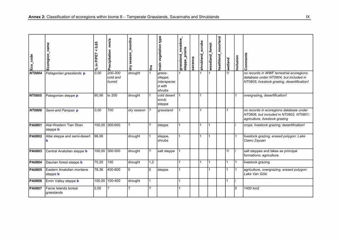
Annex 1: Classification of ecoregions within biome 7 – Tropical and Subtropical Grasslands, Savannahs and Shrublands
I
Eco_
code
Ecor
egio
n_na
me
% in
P/P
ET <
0,6
5
Prec
ipita
tion
mm
/a
dry
seas
on_m
onth
s
fire
mai
n ve
geta
tion
type
gras
slan
d_m
eado
w_
step
pe_p
rairi
e
sava
nna
shru
blan
d_sc
rubs
woo
dlan
d_fo
rest
heat
hlan
d_m
oorla
nd w
etla
nd
Incl
usio
n
Com
men
ts
AA0701 Arnhem Land tropical savanna
35,92 1200-1800 (gradient S to N)
7 m nearly rain-free; drought
1, 2 + a
eucalyptus forest
1, [2] 1 1 1 1! 1 eucalyptus forest intermixed with patches of rainforest; annual wet season floods
AA0702 Brigalow tropical savanna 82,34 500-750 drought fire + a
Acacia woodlands/scrubs
1 1 1 1 crops, livestock grazing; pockets of dry rainforest
AA0703 Cape York tropical savanna 16,22 800-2400 (gradient S to N)
6 m; drought 1, 2 + a
eucalyptus woodland
1 1 1 1 1 6 % rainforest: ~ 20 % of the national extent of rainforest occurs on the Cape York Peninsula, concentrated on the east coast; livestock grazing
AA0704 Carpentaria tropical savanna 93,54 500-750 drought 1 + a
1 1 1 1 patches of monsoon rain forest;cattle livestock grazing
AA0705 Einasleigh upland savanna 50,48 730-1000 seasonally dry
fire a 1 1 1 rainforest patches; livestock grazing
AA0706 Kimberly tropical savanna 98,95 600-1400 6 m 1 + a
1 1 1 / rainforest patches; livestock grazing
AA0707 Mitchell grass downs 100,00 350-750 long dry season, drought
1 + a
grasslands 1 1 1 / livestock grazing
AA0708 Trans Fly savanna and grasslands o
10,47 ? dry season 1 grasslands 1 1 1 1 comparable to Northern Australia
AA0709 Victoria Plains tropical savanna
100,00 600-1200 7 m 1 + a
1 1 [1] / rainforest patches; overgrazing
AT0701 Angolan Miombo woodlands b, n
5,14 800-1400 several months dry season, drought
1, 2 savannas, woodlands
1, 2 1 1 [1] 1

Annex 1: Classification of ecoregions within biome 7 – Tropical and Subtropical Grasslands, Savannahs and Shrublands
II
Eco_
code
Ecor
egio
n_na
me
% in
P/P
ET <
0,6
5
Prec
ipita
tion
mm
/a
dry
seas
on_m
onth
s
fire
mai
n ve
geta
tion
type
gras
slan
d_m
eado
w_
step
pe_p
rairi
e
sava
nna
shru
blan
d_sc
rubs
woo
dlan
d_fo
rest
heat
hlan
d_m
oorla
nd w
etla
nd
Incl
usio
n
Com
men
ts
AT0702 Angolan Mopane woodlands b, n
82,64 400-600 drought 1 1 1 1 1 1
AT0703 Ascension scrub and grasslands (93 km2) n
0,00 709 0 0 1 1 0
AT0704 Central Zambezian Miombo woodlands b, n
3,13 1000-1200 7 m drought 1,2 savannas, woodlands
1 1 1 1 1 agriculture
AT0705 East Sudanian savanna b, n 65,02 600-1000 5 m 1,2 1 1 1 agriculture
AT0706 Eastern Miombo woodlands b, n
5,28 800-1200 6 m drought 1,2 1 1 agriculture, overgrazing
AT0707 Guinean forest-savanna mosaic n
29,75 1000-1200 dry, tropical; 6 m c
1 savanna 1 1 1 1 ? transitional habitat, ecotone; predominantly savanna habitat with forest patches that run along rivers and streams
AT0708 Itigi-Sumbu thicket n 45,09 500 and 1400
7 m 1 1 1
AT0709 Kalahari Acacia-Baikiaea woodlands o
99,42 300-600 4 m; drought (every 7 y)
1,2 1 1 / livestock grazing
AT0710 Mandara Plateau mosaic n 100,00 800-1000 6 m 1,2 1 1 / crops, livestock grazing
AT0711 Northern Acacia-Commiphora bushlands and thickets n
67,80 200-600 drought 1 1 1 1 1 1 overgrazing, desertification!
AT0712 Northern Congolian forest-savanna mosaic n
11,33 1200-1600 dry season 1,2 1, 2 1 1 ? transition zone between rain forests and grasslands; abrupt habitat discontinuity between extensive Congolian rain forests and Sudanian/Sahelian grasslands; lowland rain forest in southern part (drier, semi-evergreen type), dry forest in northern parts

Annex 1: Classification of ecoregions within biome 7 – Tropical and Subtropical Grasslands, Savannahs and Shrublands
III
Eco_
code
Ecor
egio
n_na
me
% in
P/P
ET <
0,6
5
Prec
ipita
tion
mm
/a
dry
seas
on_m
onth
s
fire
mai
n ve
geta
tion
type
gras
slan
d_m
eado
w_
step
pe_p
rairi
e
sava
nna
shru
blan
d_sc
rubs
woo
dlan
d_fo
rest
heat
hlan
d_m
oorla
nd w
etla
nd
Incl
usio
n
Com
men
ts
AT0713 Sahelian Acacia savanna n 99,84 200-600 6-8 m 1,2 1 1 /
AT0714 Serengeti volcanic grasslands n
1,25 550-1050 7 m, drought 1,2 1 1 livestock grazing
AT0715 Somali Acacia-Commiphora bushlands and thickets n
97,26 100-600 drought ? woodlands, scrubs
1 1 1 1 livestock grazing
AT0716 Southern Acacia-Commiphora bushlands and thickets n
16,37 600-800 3 m 1,2 1 1 1 1 agriculture, livestock grazing
AT0717 Southern Africa bushveld n 82,06 350-750 dry season 1 1 1 livestock grazing
AT0718 Southern Congolian forest-savanna mosaic n
0,00 ? 1,2 1,2 1 1 1 ? agriculture; mix of lowland rain forest, dry forest, and secondary grassland
AT0719 Southern Miombo woodlands b, n
36,20 600-800 7 m, drought 1 woodlands 1 1 1 1 1 overlivestock grazing
AT0720 St. Helena scrub and woodlands (130 km2) n
0,00 152 drought ? 2 2 [1] natural vegetation: gumtree forest; overgrazing
AT0721 Victoria Basin forest-savanna mosaic n
0,73 ? ? ? 2 1 [1] 1! ? species from west African forest ecosystems converge with those from east African forest-savanna mosaics; forest habitats replaced by savanna, farmland, pasture
AT0722 West Sudanian savanna n 90,67 600-1000 dry season several m
1 savanna 1 1 1 crops, livestock grazing

Annex 1: Classification of ecoregions within biome 7 – Tropical and Subtropical Grasslands, Savannahs and Shrublands
IV
Eco_
code
Ecor
egio
n_na
me
% in
P/P
ET <
0,6
5
Prec
ipita
tion
mm
/a
dry
seas
on_m
onth
s
fire
mai
n ve
geta
tion
type
gras
slan
d_m
eado
w_
step
pe_p
rairi
e
sava
nna
shru
blan
d_sc
rubs
woo
dlan
d_fo
rest
heat
hlan
d_m
oorla
nd w
etla
nd
Incl
usio
n
Com
men
ts
AT0723 Western Congolian forest-savanna mosaic n
3,02 ? ? ? 1 1 1 ? dry and moist forest
AT0724 Western Zambezian grasslands n
19,08 800-1000 6 m 1, 2 1 1 1 1 livestock grazing
AT0725 Zambezian and Mopane woodlands b, n
67,67 450-710 6 m 1 1 1 1 livestock grazing
AT0726 Zambezian Baikiaea woodlands n
79,54 400-600 (800)
6 m 1 dry forest 2 1 1 1
IM0701 Terai-Duar savanna and grasslands o
37,47 dry season 1 1 1 1 1 ? river: flooding, annual monsoon floods; agriculture
NA0701 Western Gulf coastal grasslands q
38,80 300 ? 1, 2 1 1! 0 agriculture, grazing. Louisiana Coast Prairies and Marshes (232 E), Eastern Gulf Prairies and Marshes (231F), Central Gulf Prairies and Marshes (255D): 620 to 1,400 mm, water table high in many areas, resulting in poor natural drainage and an abundance of wetlands. Palustrine systems are abundant and have seasonally high water levels. Along the coast, fluvial deposition and shore zone processes are active in developing and maintaining beaches, swamps, and mud flats. Poorly drained areas along the coast support freshwater and saltwater marsh vegetation of sedges, rushes, saltgrass, and cordgrass. Vegetation: Prairie grasslands dominate areas inland from the coast and consist of little bluestem, indiangrass, switchgrass, and big bluestem. (Occasional areas of live oak are present). An abundance of palustrine systems are present, having seasonally high water level. Fire and ocean tides have probably been the principal historical disturbance. Climatic influences include occasional hurricanes. d

Annex 1: Classification of ecoregions within biome 7 – Tropical and Subtropical Grasslands, Savannahs and Shrublands
V
Eco_
code
Ecor
egio
n_na
me
% in
P/P
ET <
0,6
5
Prec
ipita
tion
mm
/a
dry
seas
on_m
onth
s
fire
mai
n ve
geta
tion
type
gras
slan
d_m
eado
w_
step
pe_p
rairi
e
sava
nna
shru
blan
d_sc
rubs
woo
dlan
d_fo
rest
heat
hlan
d_m
oorla
nd w
etla
nd
Incl
usio
n
Com
men
ts
NT0701 Arid Chaco e, p ? 350-650 dry season 1 1 1 1 1 1 overgrazing; desertification!; boundaries; 68°, 66°; 28°, 33°; NT0210 in WWF terrestrial ecoregions database
NT0702 Beni savanna p 1,26 1300-2000 dry season 1, 2 1 1 1! 0 6 m humid season: flooding covering 50-60 % of the area for 4-10 m; analogues: Pantanal, Everglades; grazing; patches of humid forest
NT0703 Campos Rupestres montane savanna p
25,65 ? 3-4 m 1, 2 1 1 1 cerrado patches; altitude 700-2000 m; livestock grazing
NT0704 Cerrado p 7,64 1250-2000 5-6 m, drought
1 cerrado vegetation (savanna-like), 95 %
1 1 1 1 1 1 mosaic of habitat types: wet and dry forests, grasslands and savannas, marshes and wetlands, gallery forests and shrublands; agriculture, livestock grazing
NT0705 Clipperton Island shrub and grasslands (29 km2) p
0,00 0
NT0706 Córdoba montane savanna p 0,00 500-900 ? ? 1 1
NT0707 Guyanan savanna p 0,00 2000-3000 4 m, droughts
1,2 savanna 1 1 1 1 1 The susceptibility to fire and its lasting effects are not typical of a humid tropical forest environment; these can only be explained by very particular conditions of ecological instability: reduced ability of the ecosystem to withstand external impacts (fire, extreme droughts), unfavorable internal factors (oligotrophic and hydric stress).The main consequence of this instability has been originated the gradual (ancient and recent) degradation of remaining forest, and its substitution by savannas
NT0708 Humid Chaco p 14,24 750-1300 ? ? 1 1 1 1 ? flooded savannas, bogs, marshes; transition zone: arid chaco and tropical humid forest; livestock grazing

Annex 1: Classification of ecoregions within biome 7 – Tropical and Subtropical Grasslands, Savannahs and Shrublands
VI
Eco_
code
Ecor
egio
n_na
me
% in
P/P
ET <
0,6
5
Prec
ipita
tion
mm
/a
dry
seas
on_m
onth
s
fire
mai
n ve
geta
tion
type
gras
slan
d_m
eado
w_
step
pe_p
rairi
e
sava
nna
shru
blan
d_sc
rubs
woo
dlan
d_fo
rest
heat
hlan
d_m
oorla
nd
wet
land
Incl
usio
n
Com
men
ts
NT0709 Llanos p 56,10 800-2500 (gradient from NE to SW)
3-5 m, drought. Seasonality less marked towards S: dry season 2 m f
1,2 savanna 1 1 1 seasonally flooded lowland savannas; Colombia lowland and Apure draining (slope in NE) to the Orinoco River; flooded savannas mainly in Venezuela (35 % of Llanos in Venezuela are seasonally flooded); most flooded area is the middle part (Apure in Venezuela); grazing; erased polygon: marshes in Apura
NT0710 Uruguayan savanna p 0,00 1000-1300 drought 2 g grasslands 1 1 1 1 ? rainfall distributed throughout the year, characterized by great variations between years. There is no marked rainy season. Great irregularity of rainfall: droughts and floods. sub humid climate: potential evapotranspiration in summer is greater than precipitation, which causes water deficiencies in the soil. The annual potential evaporation is 1,200 mm in the N and 1,000 mm in the S and is maximum in the months of 12 and 01 and minimum in 06; overgrazing; agriculture r
OC0701 Hawaii tropical high shrublands q
0,00 ? ? 1 1 1 ? 1848 km2; alpine deserts; overgrazing
OC0702 Hawaii tropical low shrublands q
0,00 ? ? 1 1 1 ? 1518 km2
OC0703 Northwestern Hawaii scrub q 0,00 700-1100 ? 1 ? 15 km2
NT0210 Chaco p, classified as Biome 7 in GIS; boundaries: 65°, 56°; 17°, 31°

Annex 2: Classification of ecoregions within biome 8 – Temperate Grasslands, Savannahs and Shrublands
VII
Eco_
code
Ecor
egio
n_na
me
% in
P/P
ET <
0,6
5
Prec
ipita
tion
mm
/a
dry
seas
on_m
onth
s
fire
mai
n ve
geta
tion
type
gras
slan
d_m
eado
w_
step
pe_p
rairi
e
sava
nna
shru
blan
d_sc
rubs
woo
dlan
d_fo
rest
heat
hlan
d_m
oorla
nd
wet
land
Incl
usio
n
Com
men
ts
AA0801 Canterbury-Otago tussock grasslands
0,00 to 500 tendency towards drought
2 grassland 1,2 1 1 1 ?
AA0802 Eastern Australia mulga shrublands
100,00 450-650 1 woodland,shrublands
1 1 1 1 /
AA0803 Southeast Australia temperate savanna
93,38 300-500 1 1 1 1
AT0801 Al Hajar Al Gharbi montane woodlands n
100,00 300-350 (2000m)
1 /
AT0802 Amsterdam and Saint-Paul Islands temperate grasslands n
0,00 1114 1 1 0 69 km2
AT0803 Tristan Da Cunha-Gough Islands shrub and grasslands n
0,00 1676 and 3397
1 1 1 0 167 km2
NA0801 California Central Valley grasslands q
87,24 2 grassland 1 1 1 1 1 agriculture, livestock grazing
NA0802 Canadian Aspen forests and parklands b, q
96,23 375-700 1 1 1 1 1 transitional ecoregion: extensive boreal-grassland transition; ; erased polygon: Lake Winnipego
NA0803 Central and Southern mixed grasslands b, q
80,48 drought 1 grassland 1 1 1 ecotone
NA0804 Central forest-grasslands transition q
21,59 600-1040 drought 1 1 1 1 1 1 ? ecotone; separates Eastern Deciduous Forests from the tallgrass and mixed grass prairies; one of the most converted of U.S. ecoregions (corn, soybeans)

Annex 2: Classification of ecoregions within biome 8 – Temperate Grasslands, Savannahs and Shrublands
VIII
Eco_
code
Ecor
egio
n_na
me
% in
P/P
ET <
0,6
5
Prec
ipita
tion
mm
/a
dry
seas
on_m
onth
s
fire
mai
n ve
geta
tion
type
gras
slan
d_m
eado
w_
step
pe_p
rairi
e
sava
nna
shru
blan
d_sc
rubs
woo
dlan
d_fo
rest
heat
hlan
d_m
oorla
nd
wet
land
Incl
usio
n
Com
men
ts
NA0805 Central tall grasslands b, q 9,69 1000 drought 1 grassland 1 1 most converted ecoregion (fertile soils: corn, soybeans), cornbelt
NA0806 Edwards Plateau savanna b,q 100,00 drought 1 1, 2 1 2 / corn, soybean; fire suppression
NA0807 Flint Hills tall grasslands b,q 0,44 drought 1 grassland 1 1 livestock grazing, crops
NA0808 Montana Valley and Foothill grasslands b
99,62 425 drought 1 grassland 1 [1] / livestock grazing, crops
NA0809 Nebraska Sand Hills mixed grasslands b
99,51 drought 1 grassland 1 1 / livestock grazing
NA0810 Northern mixed grasslands b, q
97,50 325-450 drought 1 grassland 1 1 1 1 ecotone, agriculture
NA0811 Northern short grasslands b, q
100,00 drought 1 grassland 1 1 / livestock grazing, wheat
NA0812 Northern tall grasslands b,q 89,10 450-700 drought 1 grassland 1 1 1 1 agriculture
NA0813 Palouse grasslands b, q 91,27 drought 1 grassland 1 1 wheat; erased polygon: lake Winnipego
NA0814 Texas blackland prairies b,q 70,90 drought 1 grassland 1 1 1
NA0815 Western short grasslands b, q 100,00 drought [1] grassland 1 2 / livestock grazing, crops
NT0801 Argentine Espinal p 48,38 high average precip.
N: summer rain
? deciduous shrubland-forest
1 1 1 1 1! ? considered as impoverished southern continuation of chaco region; agriculture
NT0802 Argentine Monte p 99,99 80-250 ? ? scrublands 1 1 1 1 / overgrazing, agriculture, fuelwood; desertification!
NT0803 Humid Pampas p 6,72 NE: 1600 mm, SW: 700 mm h
rain throughout the year
2 grassland 1 1 1! ? many lagoons with fresh and salt water; overgrazing, agriculture
Annex 2: Classification of ecoregions within biome 8 – Temperate Grasslands, Savannahs and Shrublands
IX
Eco_
code
Ecor
egio
n_na
me
% in
P/P
ET <
0,6
5
Prec
ipita
tion
mm
/a
dry
seas
on_m
onth
s
fire
mai
n ve
geta
tion
type
gras
slan
d_m
eado
w_
step
pe_p
rairi
e
sava
nna
shru
blan
d_sc
rubs
woo
dlan
d_fo
rest
heat
hlan
d_m
oorla
nd
wet
land
Incl
usio
n
Com
men
ts
NT0804 Patagonian grasslands p 0,00 200-300 cold and humid
drought 1 grass-steppe, interspersed with shrubs
1 1 1 1! no records in WWF terrestrial ecoregions database under NT0804, but included in NT0805; livestock grazing, desertification!
NT0805 Patagonian steppe p 90,56 to 200 drought 1 cold desert scrub steppe
1 1 1 overgrazing, desertification!
NT0806 Semi-arid Pampas p 0,00 700 dry season ? grassland 1 1 1 no records in ecoregions database under NT0806, but included in NT0802, NT0801; agriculture, livestock grazing
PA0801 Alai-Western Tian Shan steppe b
100,00 300-600 ? ? steppe 1 1 1 / crops, livestock grazing; desertification!
PA0802 Altai steppe and semi-desert b
96,08 drought 1 steppe, shrubs
1 1 1 1 livestock grazing; erased polygon: Lake Ozero Zaysan
PA0803 Central Anatolian steppe b 100,00 300-500 drought ? salt steppe 1 1! / salt steppes and lakes as principal formations; agriculture
PA0804 Daurian forest steppe b 70,20 150 drought 1,2 1 1 1 1 1 livestock grazing
PA0805 Eastern Anatolian montane steppe b
78,36 400-600 0 0 steppe 1 1 1 1 agriculture, overgrazing; erased polygon: Lake Van Gölü
PA0806 Emin Valley steppe b 100,00 100-400 drought 1 1 1 /
PA0807 Faroe Islands boreal grasslands
0,00 ? ? ? 1 0 1400 km2

Annex 2: Classification of ecoregions within biome 8 – Temperate Grasslands, Savannahs and Shrublands
X
Eco_
code
Ecor
egio
n_na
me
% in
P/P
ET <
0,6
5
Prec
ipita
tion
mm
/a
dry
seas
on_m
onth
s
fire
mai
n ve
geta
tion
type
gras
slan
d_m
eado
w_
step
pe_p
rairi
e
sava
nna
shru
blan
d_sc
rubs
woo
dlan
d_fo
rest
heat
hlan
d_m
oorla
nd
wet
land
Incl
usio
n
Com
men
ts
PA0808 Gissaro-Alai open woodlands b
83,89 500-2000 (gradient E to W)
? ? 1 1 1 foothill semideserts, alpine meadows, combined with characteristic mountain forests; agriculture, livestock grazing
PA0809 Kazakh forest steppe b 97,71 300-400 periodical droughts
1,2 1 1! 1 agriculture, livestock grazing; erased polygon: Lake Ozero Chany
PA0810 Kazakh steppe b 100,00 250-300 drought 1 steppe 1 1 1 / agriculture, livestock grazing
PA0811 Kazakh upland b 100,00 150-390 ? ? 1 1 1 1 / unusual overlap in the range of boreal, steppe and desert fauna; agriculture, livestock grazing
PA0812 Middle East steppe b 100,00 <250 drought ? open shrub steppe
1 1 1 1 / combination of arid steppe and riverine habitat; agriculture, livestock grazing
PA0813 Mongolian-Manchurian grassland b
90,79 150-400 drought ? grassland 1 1 1 1 1 overgrazing
PA0814 Pontic steppe b 95,17 250-500 drought 1 grasslands 1 1 1 1! 1 erased polygons: 3 lakes
PA0815 Sayan Intermontane steppe 0,00 low precipitation; frost; snowfall limited
? ? 1 1 ? lakes; surrounded by mountain forest; large depression; agriculture, livestock grazing
PA0816 Selenge-Orkhon forest steppe b
10,38 400-500 dry climate 1,2 i dry steppe vegetation (88%)
1 1 ? transitional zone: taiga and steppe; coniferous forest on the cooler, moist northern slopes; agriculture
PA0817 South Siberian forest steppe 97,94 ? drought ? 1 1 1 1 agriculture, overgrazing; erased polygon: lake
PA0818 Tian Shan foothill arid steppe 89,38 ? ? ? 1 1 1 1 1 overgrazing

Annex 3: Classification of ecoregions within biome 10 – Montane Grasslands and Shrublands
XI
Eco_
code
Ecor
egio
n_na
me
% in
P/P
ET <
0,6
5
Prec
ipita
tion
mm
/a
dry
seas
on_m
onth
s
fire
mai
n ve
geta
tion
type
gras
slan
d_m
eado
w_
step
pe_p
rairi
e
sava
nna
shru
blan
d_sc
rubs
woo
dlan
d_fo
rest
heat
hlan
d_m
oorla
nd
wet
land
Incl
usio
n
Com
men
ts
AA1001 Australian Alps montane grasslands
0,00 to 3800 winter drought: snow cover
1 1 1 1 1 ? Rainfall decreases at lower elevations and in east (rain concentrated in summer)
AA1002 Central Range sub-alpine grasslands o
0,00 ? ? ? 1 1 1 1 1 ? tropical evergreen forest; snow and ice fields
AA1003 South Island montane grasslands
0,00 ? ? ? 1 1 1 1 ? snow and ice fields
AT1001 Angolan montane forest-grassland mosaic n
0,00 1200-1600 Rainfall in summer, precip. from mists most of the year
2 open grassland with trees and shrubs
1,2 1 1 1 ?
AT1002 Angolan scarp savanna and woodlands n
52,30 400-800 (coast), 1600 (escarpments in E)
escarpment: rain; mist: year-round moisture
1 (grasslands in N
1 1 1 0 3 vegetation zones. (1): north of Cuanza River, mosaic of tall, tropical gallery forest and tall grassland, interdigitated by mangrove and swamp communities (2): discontinuous series of semi-deciduous humid forest patches along the higher slopes of the escarpment. (3): south of Cuanza River: arid to semi-arid undifferentiated woodlands and wooded grasslands on the Coastal Belt and lower slopes of the escarpment; excluding eastern part: humid forest
AT1003 Drakensberg alti-montane grasslands and woodlands n
0,00 1000; high winter snowfall
? 1 1 1 1 ? livestock grazing, agriculture

Annex 3: Classification of ecoregions within biome 10 – Montane Grasslands and Shrublands
XII
Eco_
code
Ecor
egio
n_na
me
% in
P/P
ET <
0,6
5
Prec
ipita
tion
mm
/a
dry
seas
on_m
onth
s
fire
mai
n ve
geta
tion
type
gras
slan
d_m
eado
w_
step
pe_p
rairi
e
sava
nna
shru
blan
d_sc
rubs
woo
dlan
d_fo
rest
heat
hlan
d_m
oorla
nd
wet
land
Incl
usio
n
Com
men
ts
AT1004 Drakensberg montane grasslands, woodlands and forests n
24,46 450-1100 (1900); little snow, severe frost
Cold and wet conditions; drought: Lesotho Plateau, rain shadow
1,2 grassland 1 1 1 ? Afromontane forest previously widespread, now only small patches; overgrazing, agriculture
AT1005 East African montane moorlands n
0,00 ? ? 2 ? mountain-top: alpine areas; livestock grazing
AT1006 Eastern Zimbabwe montane forest-grassland mosaic n
0,00 741-2997; rainy and foggy climate
3 m 1 grassland 1 1 1 ? complex mosaic of different vegetation types: relict moist evergreen forest (previously more widespread); dry montane forest (more widespread), sclerophyllous forest, miombo woodlands, tree savanna
AT1007 Ethiopian montane grasslands and woodlands n
14,98 1600 (2500) ? ? [1], 2 1 1 ? natural vegetation: mixture of closed forest in areas with higher rainfall; grassland, bushland, and thicket in other lower rainfall areas; livestock grazing, crops
AT1008 Ethiopian montane moorlands n
0,00 1000-2500 2-10 m (SW, N); frosts
2 1 [1] 1 ? livestock grazing, agriculture
AT1009 Highveld grasslands n 18,89 400-900; frosts
1; summer rain
1 1 1 altitude 1400-1800 m; agriculture, livestock grazing
AT1010 Jos Plateau forest-grassland mosaic n
0,60 1500-2000 1 1 1 1 1 ? savanna woodland as climax ecotone; S and W escarpments: relict patches of rain forest; agriculture

Annex 3: Classification of ecoregions within biome 10 – Montane Grasslands and Shrublands
XIII
Eco_
code
Ecor
egio
n_na
me
% in
P/P
ET <
0,6
5
Prec
ipita
tion
mm
/a
dry
seas
on_m
onth
s
fire
mai
n ve
geta
tion
type
gras
slan
d_m
eado
w_
step
pe_p
rairi
e
sava
nna
shru
blan
d_sc
rubs
woo
dlan
d_fo
rest
heat
hlan
d_m
oorla
nd
wet
land
Incl
usio
n
Com
men
ts
AT1011 Madagascar ericoid thickets n 0,00 to 2500 ? [1:lightning],2
1 1 ? livestock grazing
AT1012 Maputaland-Pondoland bushland and thickets n
13,00 450-800 6 m (25 % of precipitation); frostfree
0 bushland, thicket
-1 1 1 ? lines watercourses that drain into the Indian Ocean; replacing forest in areas protected from fire, but where rainfall is relatively low; overgrazing, agriculture
AT1013 Ruwenzori-Virunga montane moorlands n
0,00 ? 0 0 1 1 1 1 1! ? glaciers, snow fields; These unusual moorlands are rare in the world, found only in east and central Africa, New Guinea, and the northern Andes (where they are called páramo)
AT1014 South Malawi montane forest-grassland mosaic n
0,00 1626-2859 6 m (to 19 % of precip.)
1 1 1 1 ? lowland rainforest; agriculture;
AT1015 Southern Rift montane forest-grassland mosaic n
0,00 1500 4 m 1 grassland 1 1 1 1 ? agriculture
IM1001 Kinabalu montane alpine meadows o
0,00 ? ? ? 1 1 1 ? agriculture
NT1001 Central Andean dry puna b, e, p
58,45 < 400 7-8 m 1 j, 2 1 1 [1] 1 1 altitude > 3500 m; livestock grazing
NT1002 Central Andean puna b, e, p 47,17 400-800 j; snow capped peaks
5 m j; droughts, frosts
1 j, 2 grasslands 1 1 [1] 1 1 Connecting wet puna in N and W with dry puna in S; altitude 3200-6600 m; livestock grazing

Annex 3: Classification of ecoregions within biome 10 – Montane Grasslands and Shrublands
XIV
Eco_
code
Ecor
egio
n_na
me
% in
P/P
ET <
0,6
5
Prec
ipita
tion
mm
/a
dry
seas
on_m
onth
s
fire
mai
n ve
geta
tion
type
gras
slan
d_m
eado
w_
step
pe_p
rairi
e
sava
nna
shru
blan
d_sc
rubs
woo
dlan
d_fo
rest
heat
hlan
d_m
oorla
nd w
etla
nd
Incl
usio
n
Com
men
ts
NT1003 Central Andean wet puna n 22,33 800-1500; snow, hail; snow capped peaks j
1-2 m j; frosts
1 j, 2 1 1 1 ? wet montane grasslands; altitude > 3500 m; livestock grazing
NT1004 Cordillera Central páramo n 37,59 600-1000 (1400); cold and wet
? 1, 2 1 1 1 1 wet montane, wet scrublands; dry paramo; shrubby alpine grassland; altitude 3200-4500 m; overgrazing
NT1005 Cordillera de Merida páramo n 1,76 700-1500; snow fields k
?; severe fluctuations in humidity
1?, 2 1 1 1 dry paramo; alpine and open bunchgrass communities; altitude > 3000m; livestock grazing
NT1006 Northern Andean páramo n 4,96 ? ? 1?, 2 1 1 1 diversity of vegetation types, all sharing páramo vegetation; high alpine grasslands, bunchgrass, bogs, and open meadows;dry paramo; livestock grazing, farming
NT1007 Santa Marta páramo n 100,00 1250; 1800 NW; snow on peaks; fog, mist
? ? 1 1 1! / humid paramo; during rainy season, depressions become acid bogs; altitude 3300-5000 m; livestock grazing, agriculture
NT1008 Southern Andean steppe b, e, n
14,88 200-600; frost, snow, hail
1 ? 1 1 1 1 extreme dry conditions; eastern limit is the transition to the lower altitude and warmer Argentine Monte desert; altitude 1500-6000 m
NT1009 Zacatonal n ? temperate subhumid
? 2 1 1 [1] 0 no records in WWF terrestrial ecoregions database under NT1010; livestock grazing, agriculture; 306 km2
NT1010 High Monte b, e, n 77,01 1

Annex 3: Classification of ecoregions within biome 10 – Montane Grasslands and Shrublands
XV
Eco_
code
Ecor
egio
n_na
me
% in
P/P
ET <
0,6
5
Prec
ipita
tion
mm
/a
dry
seas
on_m
onth
s
fire
mai
n ve
geta
tion
type
gras
slan
d_m
eado
w_
step
pe_p
rairi
e
sava
nna
shru
blan
d_sc
rubs
woo
dlan
d_fo
rest
heat
hlan
d_m
oorla
nd
wet
land
Incl
usio
n
Com
men
ts
PA1001 Altai alpine meadow and tundra b
30,13 250-500 0 0 1 1 1 ? represents a complete sequence of altitudinal vegetation zones in central Siberia including steppe, forest-steppe, mixed forest, sub-alpine vegetation and alpine vegetation; alpine meadows and tundra; livestock grazing
PA1002 Central Tibetan Plateau alpine steppe b
6,07 200-400 cold, dry and windy climate
steppe 1 1 ? no forest: plateau above the 10° isotherm; altitude 3500-6000 m
PA1003 Eastern Himalayan alpine shrub and meadows o
0,00 300-3500; 5 m SW-monsoon
? ? 1 1 ? altitude 4000-5500 m
PA1004 Ghorat-Hazarajat alpine meadow
100,00 ? drought ? 1 [1] / lower areas: flooded with snowmelt in spring; livestock grazing
PA1005 Hindu Kush alpine meadow 42,43 precipitation: snow
? ? 1 1 1 ? altitude 3000-4000 m
PA1006 Karakoram-West Tibetan Plateau alpine steppe b, o
0,96 200-900 (90% snow)
? ? grasslands 1 1 1 ? glaciers; overgrazing
PA1007 Khangai Mountains alpine meadow
0,00 > 400; ice ? 1 1 1 1 ? meadow vegetation: short bushes, thickets, tundra with lichen and moss; plant species characteristic of Siberian taiga forest and Mongolian steppe; altitude 2350-2800 m; overgrazing
PA1008 Kopet Dag woodlands and forest steppe
100,00 300 1 1 1 / mountainous shrub-like Mediterranean xeric woodlands; overgrazing
PA1009 Kuhrud-Kohbanan Mountains forest steppe
100,00 100 1 ? forest steppe
1 1 / overgrazing

Annex 3: Classification of ecoregions within biome 10 – Montane Grasslands and Shrublands
XVI
Eco_
code
Ecor
egio
n_na
me
% in
P/P
ET <
0,6
5
Prec
ipita
tion
mm
/a
dry
seas
on_m
onth
s
fire
mai
n ve
geta
tion
type
gras
slan
d_m
eado
w_
step
pe_p
rairi
e
sava
nna
shru
blan
d_sc
rubs
woo
dlan
d_fo
rest
heat
hlan
d_m
oorla
nd
wet
land
Incl
usio
n
Com
men
ts
PA1010 Mediterranean High Atlas juniper steppe n
55,63 hot, dry winds; snow; rain in winter
1 1?, 2 1 1 1 northern slopes altitude >3600 m: snow cover >7 months; overgrazing
PA1011 North Tibetan Plateau-Kunlun Mountains alpine desert b
10,31 20-50: snow very short or non-existent growing season, severe drought; 9-10 m minus temperatures
0 1 [1] ? alpine vegetation: meadow, steppe, cold desert, sub-nival cushion plant communities; no forest: plateau above 10° isotherm; altitude 3500-6000 m; livestock grazing
PA1012 Northwestern Himalayan alpine shrub and meadows o
13,62 little precipitation: winter, spring; snow
arid to semi-arid
? 1 1 ? overgrazing
PA1013 Ordos Plateau steppe 98,32 160-400 l drought ? 1 1 1 / sandy dunes with desert plants; grazing, agriculture
PA1014 Pamir alpine desert and tundra
14,76 40-150; snow, rain
drought ? 1 ? grasslands and semi-deserts; no forest: plateau above 10° isotherm; strong phytogeographic affinity to the adjoining Tibetan Plateau; overgrazing, desertification!
PA1015 Qilian Mountains subalpine meadows
4,12 ? 1 ? 1 1 ? northeastern corner of Tibet-Qinghai Plateau; glaciated peaks; livestock grazing

Annex 3: Classification of ecoregions within biome 10 – Montane Grasslands and Shrublands
XVII
Eco_
code
Ecor
egio
n_na
me
% in
P/P
ET <
0,6
5
Prec
ipita
tion
mm
/a
dry
seas
on_m
onth
s
fire
mai
n ve
geta
tion
type
gras
slan
d_m
eado
w_
step
pe_p
rairi
e
sava
nna
shru
blan
d_sc
rubs
woo
dlan
d_fo
rest
heat
hlan
d_m
oorla
nd
wet
land
Incl
usio
n
Com
men
ts
PA1016 Sayan Alpine meadows and tundra
2,74 thick snowcover
? ? 1 ? moss-lichen tundra; overgrazing
PA1017 Southeast Tibet shrub and meadows b
15,19 >500 summer drought
? 1 1 ? cold desert, sub-nival cushion; eastern part of the Tibet-Qinghai Plateau; no forest: plateau above 10° isotherm; habitat similar to the alpine regions of the Eastern Himalaya; altitude 3500-6000 m; livestock grazing
PA1018 Sulaiman Range alpine meadows o
100,00 <225; snow, rain
Rainfall in every month
? 1 1 1 / altitude 1600-3500 m; overgrazing
PA1019 Tian Shan montane steppe and meadows
53,50 100-800; snow
drought stress at lower altitudes
? 1 1 ? intercept moist arctic air from NW, especially during winter; overgrazing
PA1020 Tibetan Plateau alpine shrub and meadows b
9,76 400-500 ? ? 1 [1] ? transition zone: wet sedge meadows of eastern Tibet merge with semi-arid steppes and cold deserts of western part of the Tibetan Plateau; altitude 4000-4500 m; no trees plateau above the 10° isotherm; livestock grazing
PA1021 Western Himalayan alpine shrub and meadows o
0,00 1500-1900; snow
0 0 1 1 ? 25 % bare rock and ice;altitude 3000-5000 m; livestock grazing
PA1022 Yarlung Tsangpo arid steppe b
0,00 200-500 ? ? 1 1 [1] ? Tibetan Plateau; no forest: plateau above the 10° isotherm; altitude 3500-6000 m

Annex 4: Classification of ecoregions within biome 12 – Mediterranean Forests, Woodlands and Scrub
XVIII
Eco_
code
Ecor
egio
n_na
me
% in
P/P
ET <
0,6
5
Prec
ipita
tion
mm
/a
dry
seas
on_m
onth
s
fire
mai
n ve
geta
tion
type
gras
slan
d_m
eado
w_
step
pe_p
rairi
e
sava
nna
shru
blan
d_sc
rubs
woo
dlan
d_fo
rest
heat
hlan
d_m
oorla
nd w
etla
nd
Incl
usio
n
Com
men
ts
AA1201 Coolgardie woodlands 100,00 ? 2 a 1 1 /
AA1202 Esperance mallee 99,96 summer drought
1 shrublands 1 /
AA1203 Eyre and York mallee 99,28 350-600 summer drought
1 1 1 1 /
AA1204 Jarrah-Karri forest and shrublands
26,65 to 1400 (coast)
marked summer drought
2 evergreen forest
1 1 1 1 evergreen forests can be very moist in winter, but lack the abundant epiphytes, liverworts, ferns, and mosses that characterize rainforest, probably due to the dry summer season
AA1205 Swan Coastal Plain Scrub and Woodlands
60,43 summer drought
1 1 1 1 1 variety of vegetation, from coastal dunes and sandplains to woodlands
AA1206 Mount Lofty woodlands 95,32 400-900 summer drought
1 1 1 1
AA1207 Murray-Darling woodlands and mallee
99,78 250-400 summer drought
1 woodlands 1 1 /
AA1208 Naracoorte woodlands 49,39 400 (north) to 850 (south)
most rain falling in winter
2 a sclerophyll forest, woodland
1 1 1 1! 1 Low topography coupled with high rainfall results in many areas being waterlogged part of the year. An extensive series of freshwater lagoons lies behind the coastal foredunes along the southern part of the coastline; excluding south?
AA1209 Southwest Australia savanna 99,81 summer drought
2 a 1 1 1 1
AA1210 Southwest Australia woodlands
58,91 635-1300 pronounced summer drought
2 a forest 1 1
AT1201 Albany thickets n 98,83 250-550 summer drought
1 shrublands 1 /

Annex 4: Classification of ecoregions within biome 12 – Mediterranean Forests, Woodlands and Scrub
XIX
Eco_
code
Ecor
egio
n_na
me
% in
P/P
ET <
0,6
5
Prec
ipita
tion
mm
/a
dry
seas
on_m
onth
s
fire
mai
n ve
geta
tion
type
gras
slan
d_m
eado
w_
step
pe_p
rairi
e
sava
nna
shru
blan
d_sc
rubs
woo
dlan
d_fo
rest
heat
hlan
d_m
oorla
nd w
etla
nd
Incl
usio
n
Com
men
ts
AT1202 Lowland fynbos and renosterveld n
72,98 250-2000 summer drought
1 shrubs 1 1
AT1203 Montane fynbos and renosterveld n
82,07 300-2000 (3000)
? 1 shrubs 1 1
NA1201 California coastal sage and chaparral q
95,05 150-500 summer drought (2-4 m)
1,2 shrubland, oak woodland
1 1 1 1 1
NA1202 California interior chaparral and woodlands q
61,47 250-1280 (1790) m
summer drought (2-4 m)
1 oak savannas, chaparral
1 1 1 1 1 1
NA1203 California montane chaparral and woodlands q
99,83 310-1020 m summer drought (2-4 m)
1 1 1 1 / mosaic of shrubland, woodland, forest, alpine habitats
NT1201 Chilean matorral p 72,50 summer drought
2 scrubs 1 1 1
PA1201 Aegean and Western Turkey sclerophyllous and mixed forests
56,96 600-1350 summer drought
? Maquis (evergreen shrubs and pine)
1 1 1
PA1202 Anatolian conifer and deciduous mixed forests
66,15 400-600 summer drought
? pine forest, pine and oak woodlands and
1 1 1
PA1203 Canary Islands dry woodlands and forests
70,43 100-650 ? 2 1 1 1 1

Annex 4: Classification of ecoregions within biome 12 – Mediterranean Forests, Woodlands and Scrub
XX
Eco_
code
Ecor
egio
n_na
me
% in
P/P
ET <
0,6
5
Prec
ipita
tion
mm
/a
dry
seas
on_m
onth
s
fire
mai
n ve
geta
tion
type
gras
slan
d_m
eado
w_
step
pe_p
rairi
e
sava
nna
shru
blan
d_sc
rubs
woo
dlan
d_fo
rest
heat
hlan
d_m
oorla
nd w
etla
nd
Incl
usio
n
Com
men
ts
PA1204 Corsican montane broadleaf and mixed forests
19,15 short summer drought
2 forest 1 1 1
PA1205 Crete Mediterranean forests 79,90 300-1400 drought forest 2 1 1 1
PA1206 Cyprus Mediterranean forests 99,46 300-1100 summer drought
2 forest 2 1 1 /
PA1207 Eastern Mediterranean conifer-sclerophyllous-broadleaf forests
95,55 400-1250 summer drought
2 1 1 1 1
PA1208 Iberian conifer forests 100,00 1100 (1500) ? 2 forest 1 /
PA1209 Iberian sclerophyllous and semi-deciduous forests
87,55 300-850 summer drought
2 1 1 1 1
PA1210 Illyrian deciduous forests 0,00 1500-2000 (3000)
summer drought
? forest 1 1 1
PA1211 Italian sclerophyllous and semi-deciduous forests
7,00 to 1800 summer drought
2 forest 2 1 1
PA1212 Mediterranean acacia-argania dry woodlands and succulent thickets
99,80 100-500 ? ? 1 1 /
PA1213 Mediterranean dry woodlands and steppe
92,11 100-300 summer drought
? 1 1 1 1
PA1214 Mediterranean woodlands and forests
83,20 350-800 summer drought
? forest 1 1 1
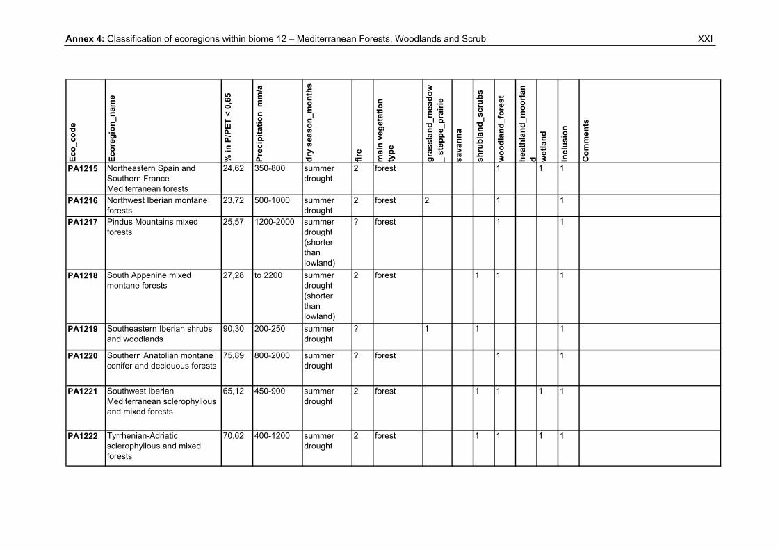
Annex 4: Classification of ecoregions within biome 12 – Mediterranean Forests, Woodlands and Scrub
XXI
Eco_
code
Ecor
egio
n_na
me
% in
P/P
ET <
0,6
5
Prec
ipita
tion
mm
/a
dry
seas
on_m
onth
s
fire
mai
n ve
geta
tion
type
gras
slan
d_m
eado
w_
step
pe_p
rairi
e
sava
nna
shru
blan
d_sc
rubs
woo
dlan
d_fo
rest
heat
hlan
d_m
oorla
nd w
etla
nd
Incl
usio
n
Com
men
ts
PA1215 Northeastern Spain and Southern France Mediterranean forests
24,62 350-800 summer drought
2 forest 1 1 1
PA1216 Northwest Iberian montane forests
23,72 500-1000 summer drought
2 forest 2 1 1
PA1217 Pindus Mountains mixed forests
25,57 1200-2000 summer drought (shorter than lowland)
? forest 1 1
PA1218 South Appenine mixed montane forests
27,28 to 2200 summer drought (shorter than lowland)
2 forest 1 1 1
PA1219 Southeastern Iberian shrubs and woodlands
90,30 200-250 summer drought
? 1 1 1
PA1220 Southern Anatolian montane conifer and deciduous forests
75,89 800-2000 summer drought
? forest 1 1
PA1221 Southwest Iberian Mediterranean sclerophyllous and mixed forests
65,12 450-900 summer drought
2 forest 1 1 1 1
PA1222 Tyrrhenian-Adriatic sclerophyllous and mixed forests
70,62 400-1200 summer drought
2 forest 1 1 1 1

Annex 5: Percentage of ecoregions within biome 13 (Deserts & xeric Shrublands) in P/PET < 0.65
XXII
Eco_code Ecoregion_name % in P/PET < 0,65
AA1301 Carnarvon xeric shrublands 99,40
AA1302 Central Ranges xeric scrub 100,00
AA1303 Gibson desert 100,00
AA1304 Great Sandy-Tanami desert 100,00
AA1305 Great Victoria desert 100,00
AA1306 Nullarbor Plains xeric shrublands 100,00
AA1307 Pilbara shrublands 99,69
AA1308 Simpson desert 98,30
AA1309 Tirari-Sturt stony desert 96,63
AA1310 Western Australian Mulga shrublands 100,00
AT1301 Aldabra Island xeric scrub n 0,00
AT1302 Arabian Peninsula coastal fog desert n 94,82
AT1303 East Saharan montane xeric woodlands n 100,00
AT1304 Eritrean coastal desert n 99,40
AT1305 Ethiopian xeric grasslands and shrublands n 99,36
AT1306 Gulf of Oman desert and semi-desertn 97,31
AT1307 Hobyo grasslands and shrublands n 93,80
AT1308 Ile Europa and Bassas da India xeric scrub n 0,00
AT1309 Kalahari xeric savanna n 100,00
AT1310 Kaokoveld desert n 95,61
AT1311 Madagascar spiny thickets n 89,21
AT1312 Madagascar succulent woodlands n 92,22
AT1313 Masai xeric grasslands and shrublands n 97,61
AT1314 Nama Karoo n 99,22
AT1315 Namib desert n 99,98
AT1316 Namibian savanna woodlands n 95,12
AT1318 Socotra Island xeric shrublands n 87,78
AT1319 Somali montane xeric woodlands n 99,44
AT1320 Southwestern Arabian foothills savanna n 99,94
AT1321 Southwestern Arabian montane woodlands n 100,00
AT1322 Succulent Karoo n 99,67
IM1301 Deccan thorn scrub forests o 73,62
IM1302 Indus Valley desert 100,00
IM1303 Northwestern thorn scrub forests 99,69
IM1304 Thar desert 100,00

Annex 5: Percentage of ecoregions within biome 13 (Deserts & xeric Shrublands) in P/PET < 0.65
XXIII
Eco_code Ecoregion_name % in P/PET < 0,65
NA1301 Baja California desert q 98,78
NA1302 Central Mexican matorral q 65,95
NA1303 Chihuahuan desert q 100,00
NA1304 Colorado Plateau shrublands q 99,00
NA1305 Great Basin shrub steppe (erased polygon: lake) q 96,97
NA1306 Gulf of California xeric scrub q 96,71
NA1307 Meseta Central matorral q 97,50
NA1308 Mojave desert q 100,00
NA1309 Snake-Columbia shrub steppe q 96,94
NA1310 Sonoran desert q 99,22
NA1311 Tamaulipan matorral q 100,00
NA1312 Tamaulipan mezquital q 100,00
NA1313 Wyoming Basin shrub steppe q 98,38
NT1301 Araya and Paria xeric scrub p 71,82
NT1303 Atacama desert p 98,91
NT1304 Caatinga p 95,91
NT1305 Caribbean shrublands p 0,00
NT1306 Cuban cactus scrub p 34,62
NT1307 Galápagos Islands xeric scrub p 88,04
NT1308 Guajira-Barranquilla xeric scrub p 98,93
NT1309 La Costa xeric shrublands p 99,99
NT1311 Malpelo Island xeric scrub p 0,00
NT1312 Motagua Valley thornscrub p 0,00
NT1313 Paraguana xeric scrub p 99,97
NT1314 San Lucan xeric scrub q 98,91
NT1315 Sechura desert p 85,34
NT1316 Tehuacán Valley matorral q 0,00
NT1318 St. Peter and St. Paul rocks p 0,00
PA1301 Afghan Mountains semi-desert 87,83
PA1302 Alashan Plateau semi-desert 99,32
PA1303 Arabian Desert and East Sahero-Arabian xeric shrublands 99,99
PA1304 Atlantic coastal desert n 99,86
PA1305 Azerbaijan shrub desert and steppe 71,31
PA1306 Badghyz and Karabil semi-desert 100,00
PA1307 Baluchistan xeric woodlands 99,95

Annex 5: Percentage of ecoregions within biome 13 (Deserts & xeric Shrublands) in P/PET < 0.65
XXIV
Eco_code Ecoregion_name % in P/PET < 0,65
PA1308 Caspian lowland desert 93,72
PA1309 Central Afghan Mountains xeric woodlands 100,00
PA1310 Central Asian northern desert 96,26
PA1311 Central Asian riparian woodlands 95,48
PA1312 Central Asian southern desert 99,73
PA1313 Central Persian desert basins 99,64
PA1314 Eastern Gobi desert steppe 100,00
PA1315 Gobi Lakes Valley desert steppe 77,85
PA1316 Great Lakes Basin desert steppe 69,90
PA1317 Junggar Basin semi-desert (erased polygon: lake) 98,67
PA1318 Kazakh semi-desert 98,71
PA1319 Kopet Dag semi-desert 100,00
PA1320 Mesopotamian shrub desert 100,00
PA1321 North Saharan steppe and woodlands n 100,00
PA1322 Paropamisus xeric woodlands 94,18
PA1323 Persian Gulf desert and semi-desert 97,32
PA1324 Qaidam Basin semi-desert 62,68
PA1325 Red Sea Nubo-Sindian tropical desert and semi-desert 99,92
PA1326 Registan-North Pakistan sandy desert 100,00
PA1327 Sahara desert (erased polygon: lake) n 99,82
PA1328 South Iran Nubo-Sindian desert and semi-desert 98,92
PA1329 South Saharan steppe and woodlands n 100,00
PA1330 Taklimakan desert 98,97
PA1331 Tibesti-Jebel Uweinat montane xeric woodlands n 100,00
PA1332 West Saharan montane xeric woodlands n 100,00
PA1333 Red Sea coastal desert n 99,75

Annex 6: Explanations to Annexes 1 - 5
XXV
Symbols within the tables 0 In general: Dryland feature does not occur within the ecoregion
Inclusion column: areas with the P/PET ratio ≥ 0.65 are ‘presumed excluded’
from the CBD PoW on Dry and Subhumid Lands
1 In general: Dryland feature/vegetation type occurs naturally within the concerned
ecoregion
Inclusion column: areas with the P/PET ratio ≥ 0.65 are ‘presumed included’ in
the CBD PoW on Dry and Subhumid Lands
2 Anthropogenic dryland feature/vegetation type occurs within the concerned
ecoregion
[ ] Dryland feature/vegetation type occurs naturally within the concerned ecoregion,
but to a restricted extent
/ Ecoregion is entirely situated in zones with the ratio P/PET < 0.65. Hence, no
parts need to be defined as ‘presumed excluded’ or ‘presumed ‘included’
? In general: The consulted sources did not contain information about dryland
features within the concerned ecoregions.
Inclusion column: areas with the P/PET ratio ≥ 0.65 need to be reviewed. They
do not show enough dryland features for an inclusion in the CBD PoW. These
ecoregions are highlighted in light yellow.
Abbreviations within the tables m months
N North
E East
S South
W West
precip. precipitation

Annex 6: Explanations to Annexes 1 - 5
XXVI
Characters within the tables A Gill, A. M. et al. (1999) b area mentioned in: UNEP/CBD/SBSTTA11/4/Add.1 (2005)
c Central Intelligence Agency (CIA) (2007) d Mc Nab, W.H., Avers, P.E (1994) e area mentioned in: LADA, WRI (2004) f Rivas, J. A. et al. (2002) g Mutch, R.W. (2001) h Penalba, O.C., Robledo, F.A. (2005) i Shulman, D. (1996) j Davis, S.D. et al. (eds.) (1997) k Monasterio, M., Molinillo, M. (2003) l Hong Jiang et al. (1995) m Bailey, R. G. (1995) n Burgess, N. et al. (2004) o Wikramanayake, E. et al. (2002) p Dinerstein, E. et al. (1995) q Ricketts, T.H. et al. (1999)