Embed Size (px)
Citation preview
Learnings from MoUD's TOD Guidance Document and Smart City Plans
A SMART(ER)
TOD
National Institute of Urban Affairs

{2} A SMART(ER) TOD

A SMART(ER) TOD {3}
Published by
National Institute of Urban Affairs
1st and 2nd Floor, Core 4B, India Habitat Centre
Lodhi Road, New Delhi - 110003. India
www.niua.org
Copyright © 2017
National Institute of Urban Affairs (India)
and
Foreign & Commonwealth Office (UK)
All rights reserved. No part of this publication may be reproduced, distributed, or
transmitted in any form or by any means, including photocopying, recording, or
other electronic or mechanical methods, without the prior written permission of the
publisher, except in the case of brief quotations embodied in critical reviews and
certain other noncommercial uses permitted by copyright law.
Learnings from MoUD's TOD Guidance Document and Smart City Plans
A SMART(ER)
TODLearnings from MoUD's TOD Guidance Document and Smart City Plans
A SMART(ER)
National Institute of Urban Affairs
Acknowledgements
Prof. Jagan Shah
(Director NIUA)
Research, Compilation and Analysis
Rewa Marathe
Siddharth Pandit
Suzana Jacob
Neha Awasthi
Raman Kumar Singh
Sabina Suri
Divya Jindal
Anand Iyer
Technical Partners: RICS India
D. T. V. Raghu Rama Swamy
Ashish Gupta
Dr. Anil Sawhney
Sunil Agarwal
Expert Advisors
Akshima Ghate (The Energy & Resource Institute)
Arun Rewal (Arun Rewal Associates)
Banashree Banerjee (Institute of Housing & Urban Development Studies)
Dr. Divya Sharma (Oxford Policy Management)
Mriganka Saxena (Habitat Tectonics Architecture & Urbanism)
Graphic Design
Deep Pahwa
Kavita Rawat
Copy Editor
Razia Grover
A SMART(ER) TOD {3}
ForewordThe Smart City Mission has directed the attention of the urban sector in India to the need and benefits of following an integrated approach
to the formulation of city development strategies and the preparation of purposeful projects which can be implemented with efficiency.
The Mission has also made us highly conscious of the interrelationships between planning, governance, finance and capacity; the fact that
all these aspects must be addressed while envisaging a project or a development strategy. The outcomes that are expected from such an
integrated and holistic approach are an improved quality of life, better quality of assets and enhanced efficiency and sustainability.
One of the fundamental principles of smart cities is the integration between land use and transportation. Urban historians will remind us
that this integration is at the heart of city planning. Even a cursory glance at the oldest cities, which we admire for their streets and public
places as much as their buildings, reveals the inherent bond between the spaces for movement and the spaces for rest. However, this bond
became weak during the late 20th century because of proliferating modes of personal transportation and rampant unplanned urbanisation,
which skewed the balance between density of population and land use and provision of basic services. The ‘smart’ city is one that aims to
restore the balance and to reclaim the public purpose of cities, which is expected to result in improved economic and social performance.
Over the last several months, NIUA was engaged in a research project on Transit Oriented Development in Indian Smart Cities. As a part of
this project, NIUA published ‘Transit Oriented Development for Indian Smart Cities — A Global Review of Transportation-Land-Use Integration’
in September 2016. This publication established five constructs-Urban Density, Urban Diversity, Urban Design, Housing and Mobility — as
the core themes in a TOD. This publication was followed up by interactions with over 10 Indian smart cities through national, international
workshops and an international immersion visit. NIUA is now pleased to published the final set of deliverables in this project. It includes
three Guidance Documents with the purpose of helping Indian smart cities in the process of implementing TOD. The three Guidance
Documents are:
• A Smart(er) TOD — Learnings from MoUD’s TOD Guidance Document and Smart City Plans is a study of TODs in 21 Smart Cities
with respect to the Ministry of Urban Developments’ TOD Guidance document.
• Game Changers in Transit Oriented Development discuss two important tools in operationalising TOD- Value Capture Financing for
financial sustainability and Form-Based Codes for community-driven urban design.
• Assessing TOD — A List of Indicators compiles indicators of TOD within the five constructs established in Transit Oriented Development
for Indian Smart Cities — A Global Review of Transportation-Land-Use Integration.
These publications illustrate the opportunity, role and scope of TOD in Indian Smart Cities.
We are thankful to the group of expert advisers — Arun Rewal, Banashree Banerjee, Dr. Divya Sharma, Mriganka Saxena, and Akshima Ghate
— who have shared their wisdom and experience with the NIUA team and our technical partners from RICS India, D.T.V. Raghu Ramaswamy,
Ashish Gupta, Dr. Anil Sawhney and Sunil Agarwal. The project has been made possible through the generous funding provided by the
Prosperity Fund of the Foreign & Commonwealth Office of the United Kingdom and the support and encouragement provided by Ms. Natalie
Toms, Mr. Sushil Rana and the team at the UK High Commission.
Prof. Jagan ShahDirector, NIUA
{4} A SMART(ER) TOD
List of Abbreviations
ABD: Area Based DevelopmentAMRUT: Atal Mission for Rejuvenation and Urban TransformationASSOCHAM: Associated Chambers of Commerce and Industry of
IndiaBBSR: BhubaneswarBPTSL: Bhubaneswar Public Transport Service LimitedBIT: Birla Institute of TechnologyBRT: Bus Rapid TransportBSUP: Basic Services for Urban PoorCBD: Central Business DistrictCCP: Corporation of City of PanajiCCTV: Close Circuit Tele-visionCDP: City Development PlanCNTA: Chota Nagpur Tenancy ActCRZ: Coastal Regulation ZoneCSR: Corporate Social ResponsibilityCTTP: City Traffic & Transportation PlanDCR: Development Control RegulationDMA: Directorate of Municipal Administration DPC: District Planning CommitteeDUTF: Dedicated Urban Transport Fund. EDC: Economic Development Corporation LtdEWS: Economically Weaker SectionFAR: Floor Area RatioFSI: Floor Space IndexFCO: Foreign & Commonwealth OfficeFMCG: Fast Moving Consumer GoodsGHAG: Goa Heritage Action GroupGLDBCR: Goa Land Development & Building Construction RegulationsGoI: Government of IndiaGoJ: Government of JharkhandGoG: Government of GoaGoMP: Government of Madhya PradeshGoK: Government of KarnatakaGRP: Goa Regional Plan
GSIDCL: Goa State Infrastructure Development Corporation Ltd.HDMC: Hubli-Dharwad Municipal CorporationHEC: Heavy Engineering Corporation LtdHIG: High Income GroupICLEI-Local Governments for Sustainability — South Asia:
International Council for Local Environmental InitiativesICT: Information Communication TechnologyIIM: Indian Institute of ManagementIPSCDL: Imagine Panaji Smart City Development LimitedIPT: Intermediate Para TransitITDP: Institute for Transportation Development PolicyITMS: Intelligent Transport Management SystemIUT: Institute of Urban TransportJICA: Japan International Cooperation AgencyJnNURM: Jawaharlal Nehru National Urban Renewal MissionJSUDP: Jharkhand Sustainable Urban Development ProjectKIADB: Karnataka Industrial Areas Development BoardKRDCL: Karnataka Road Development Corporation LimitedKTC: Kadamba Transport CorporationKUIDFC: Karnataka Urban Infrastructure Development and Finance
CorporationLIG: Lower Income GroupLRT: Light Rail TransportMIG: Medium Income GroupMNRE: Ministry of New & Renewable EnergyMoUD: Ministry of Urban DevelopmentMRTS: Mass Rapid Transit SystemNABARD: National Bank for Agriculture and Rural DevelopmentNIFFT: National Institute of Foundry and Forge TechnologyNIUA: National Institute of Urban DevelopmentNKDA: New Town Kolkata Development AuthorityNMT: Non Motorised TransportNWKRTC: North West Karnataka Road Transport CorporationODP: Outline Development PlanPBS: Public Bike Share
A SMART(ER) TOD {5}
PHPDT: Peak Hour Peak District TrafficPMAY: Pradhaan Mantri Awas YojanaPPH: Persons Per HectareRAY: Rajiv Awas YojnaRCDP: Revised City Development PlanRIADA: Ranchi Industrial Area Development AuthorityROW: Right of WayRMC: Ranchi Municipal CorporationRRDA: Ranchi Regional Development AuthoritySBM: Swachh Bharat Mission
SCP: Smart City PlansSPV: Special Purpose VehicleTERI: The Energy and Resources InstituteTOD: Transit Oriented DevelopmentTOZ: Transit Oriented ZoneUIDF: Ujjain Infrastructure development FundULB: Urban Local BodiesUMTA: Urban Metropolitan Transportation AuthorityXISS: Xavier Institute of Social Service
{6} A SMART(ER) TOD
TOD AND INDIAN SMART CITIES............................................................................................... 8
Introduction
Smart City Mission Guidelines, TOD Guidance Document & the Global Review Document
Analysing the Smart City Plans
PART I: OVERVIEW ANALYSIS OF 17 SMART CITIES .....................................................14
Gwalior .................................................................................................................................................................................................................................... 16
Bhubaneswar ...................................................................................................................................................................................................................... 18
Bhopal ....................................................................................................................................................................................................................................20
Ajmer ....................................................................................................................................................................................................................................... 22
Thane ....................................................................................................................................................................................................................................... 24
Jabalpur ................................................................................................................................................................................................................................ 26
Guwahati .............................................................................................................................................................................................................................. 28
Chandigarh .......................................................................................................................................................................................................................... 30
Chennai...................................................................................................................................................................................................................................32
Amritsar ..................................................................................................................................................................................................................................34
Kochi ....................................................................................................................................................................................................................................... 36
Contents
A SMART(ER) TOD {7}
Nagpur ................................................................................................................................................................................................................................... 38
Indore ......................................................................................................................................................................................................................................40
Agra .......................................................................................................................................................................................................................................... 42
Faridabad ............................................................................................................................................................................................................................. 44
New Town Kolkata .......................................................................................................................................................................................................... 46
Ahmedabad ........................................................................................................................................................................................................................ 48
PART II: AN IN-DEPTH ANALYSIS OF SMART CITY PLANS ..................................... 50
Ranchi..................................................................................................................................................................................................................................... 52
Panaji ......................................................................................................................................................................................................................................66
Hubli-Dharwad .................................................................................................................................................................................................................80
Ujjain .......................................................................................................................................................................................................................................90
Annexure I ..........................................................................................................................................................................................................................100
Annexure II...........................................................................................................................................................................................................................112
Endnotes ...............................................................................................................................................................................................................................113
{8} A SMART(ER) TOD
INTRODUCTIONRapid economic development in globalised India has led to an immense pressure on the urban infrastructure of the country. With an ever growing population, the country needs to manage its growth through sustainable practices of land use and transportation. Transit Oriented Development (TOD) is a globally recognised approach for achieving sustainability through land-use-transportation integration. It can be used effectively to create high density, compact neighbourhoods supported by public transit, to reduce the dependence on private vehicles and the resulting pollution and congestion. The Ministry of Urban Development's (MoUD) National Smart City Mission presents a timely opportunity and support for many cities to adopt this approach. MoUD's document, the Smart City Mission Guidelines, recommends the use of a TOD as a means of addressing some pressing issues of housing, mobility and infrastructure that Indian cities are struggling with. MoUD has also published a Guidance Document for planning and implementing a TOD in an Indian city. Its purpose is to assist various government organisations, public authorities and development professionals in India, in the process of integrating sustainable transport planning principles in diverse urban contexts. The document is also meant to be used to evaluate the implementation of projects under the Smart City Mission. However, it is important to note that there are several limitations to this due to the reasons listed below:
• MoUD's Guidance Document for TOD was published about one year after the publication of Smart City Mission Guidelines and
the preparation of Smart City Plans (SCP) by the participating cities.
• The Guidance Document presents a technical approach to planning and implementing TOD according to the needs of each city; whereas the Guidelines for the Smart Cities Mission recommends a broader city level strategic approach, where TOD is one of the possible solutions. This limits the use of MoUD's Guidance Document in assessing the SCPs.
• The Guidance Document recommends identification of scale and site of a TOD based on the availability of resources and enabling environment. Site selection and selection of TOD as an approach in the Smart City Mission depends on the availability of suitable land and expert opinion and citizen engagement.
In order to use MoUD's Guidance Document in the assessment of the SCPs, it is important to first identify where the TOD planning and implementation process recommended under each of these two approaches aligns. This publication attempts to do so and presents a method for assessing individual TOD projects that have been incorporated in SCPs. There are four parts to this process:
1. Understanding the TOD planning and implementation process under the Smart City Mission Guidelines and the TOD Guidance Document.
2. Identifying and listing of projects proposed in the SCPs for TOD implementation.
3. Analysis of the projects from SCPs using the recommendations in
TOD AND INDIAN SMART CITIES
A SMART(ER) TOD {9}
the TOD Guidance Document, based on the association identified in 1.
4. Illustrating use of the TOD Guidance Document to assess the SCPs.
The next section explains the association between the Smart City Mission Guidelines, MoUD's TOD Guidance Document and the Global Review Document on Transportation-Land-Use Integration.
SMART CITY MISSION GUIDELINES, TOD GUIDANCE DOCUMENT AND THE GLOBAL REVIEW DOCUMENT
Smart City Mission Guidelines
The purpose of the National Smart City Mission is to drive economic growth and improve the quality of life of people in Indian cities by enabling local area development and harnessing technology, especially technology that leads to "smart" outcomes. It proposes to do so through projects implemented in the form of:
• Pan City Initiatives that are city level interventions, focusing on smart solutions and technology.
• Area Based Development (ABD) projects for a specific site in the city, which include interventions that focus on developing/retrofitting/redeveloping the site. Area Based Development presents an opportunity for the city to test some of its projects before they can be replicated across the city.
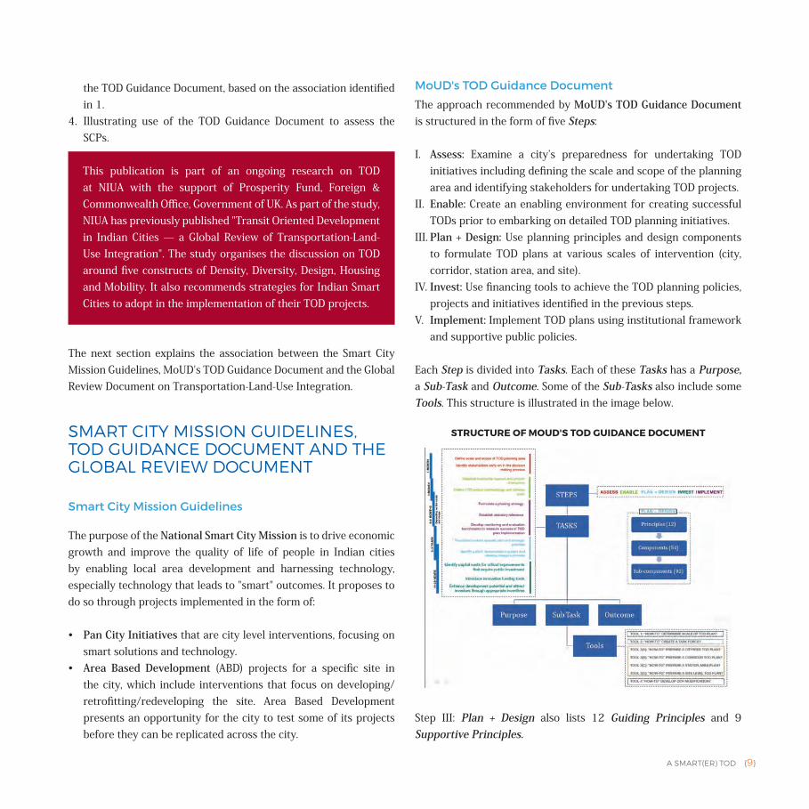
MoUD's TOD Guidance Document
The approach recommended by MoUD's TOD Guidance Document is structured in the form of five Steps:
I. Assess: Examine a city’s preparedness for undertaking TOD initiatives including defining the scale and scope of the planning area and identifying stakeholders for undertaking TOD projects.
II. Enable: Create an enabling environment for creating successful TODs prior to embarking on detailed TOD planning initiatives.
III. Plan + Design: Use planning principles and design components to formulate TOD plans at various scales of intervention (city, corridor, station area, and site).
IV. Invest: Use financing tools to achieve the TOD planning policies, projects and initiatives identified in the previous steps.
V. Implement: Implement TOD plans using institutional framework and supportive public policies.
Each Step is divided into Tasks. Each of these Tasks has a Purpose, a Sub-Task and Outcome. Some of the Sub-Tasks also include some Tools. This structure is illustrated in the image below.
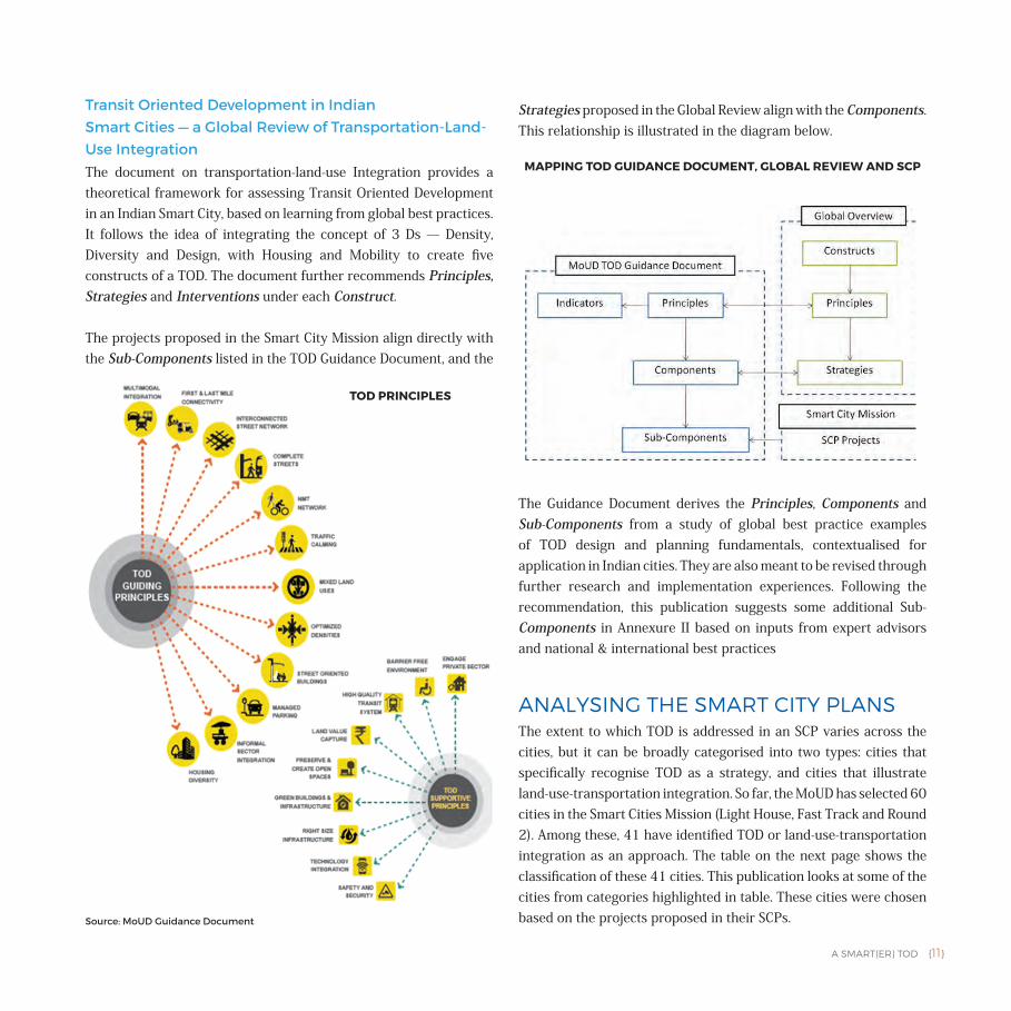
Step III: Plan + Design also lists 12 Guiding Principles and 9 Supportive Principles.
This publication is part of an ongoing research on TOD at NIUA with the support of Prosperity Fund, Foreign & Commonwealth Office, Government of UK. As part of the study, NIUA has previously published "Transit Oriented Development in Indian Cities — a Global Review of Transportation-Land-Use Integration". The study organises the discussion on TOD around five constructs of Density, Diversity, Design, Housing and Mobility. It also recommends strategies for Indian Smart Cities to adopt in the implementation of their TOD projects.
STRUCTURE OF MOUD'S TOD GUIDANCE DOCUMENT
{10} A SMART(ER) TOD
These Principles are as follows:
Guiding Principles:
1. Multi-modal Integration: Ensure efficient movement and provide seamless connectivity between local, regional, and rapid transit services.
2. First and Last Mile Connectivity: Strengthen first and last mile connections.
3. Interconnected Street Network: Develop an interconnected network of streets and blocks.
4. Complete Streets: Create a network of complete streets which are designed to accommodate maximum pedestrian rather than vehicular movement.
5. NMT Network: Create comfortable and attractive pedestrian linkages to and from all transit stations in order to support a walkable station area and promote the use of transit.
6. Traffic Calming: Reduce both vehicle speed and volume on roadways.
7. Mixed Land Uses: Allow mix of uses and activities. 8. Optimised Densities: Develop areas to optimum densities for
sustainable infrastructure service delivery.9. Street Oriented Buildings: Orient buildings towards pedestrian
movement and streets with active uses located along the sidewalk.10. Managed Parking: Organise and prioritise parking based on
distance from the TOD station area or corridor to disincentivise use of private vehicles.
11. Informal Sector Integration: Integrate spaces for street vendors into the urban fabric.
12. Housing Diversity: Increase the formal supply of housing stock along transit corridors and station facilities with increased options for different income groups in the city.
Supportive Principles:
1. Engage Private Sector: Foster private sector participation in the TOD planning and implementation process, including financing infrastructure upgrades related to real estate development.
2. Barrier Free Environment: Build and retrofit the pedestrian
environment to meet or exceed accessibility guidelines and standards.
3. High Quality Transit System: Encourage high-quality transit system design including station/stop architecture and provide a minimum level of customer amenity to enhance customer comfort, safety, and information.
4. Land Value Capture: Use development based Land Value Capture as a financing mechanism for upgrading infrastructure along TOD corridors and station areas.
5. Preserve and Create Open Spaces: Preserve open areas such as amenity spaces, green spaces, playgrounds, parks and natural areas as an integral component of TODs at all scales.
6. Green Building and Infrastructure: Prioritise and implement proven and innovative sustainable building, energy, water, landscape and waste management practices.
7. Right Size Infrastructure: Gauge the carrying capacities of existing infrastructure and accordingly propose increased densities in station areas or upgrade infrastructure as part of the TOD project.
8. Technology Integration: Integrate innovative technologies within TOD plans from the beginning; this will provide an edge for transit service to compete with automobiles. Smart parking management, fare integration, information integration are a few of the key project components.
9. Safety and Security: Incorporate design principles that optimise natural surveillance and enhance safety by creating safe refuge points for women and persons with disabilities by introducing 24 x 7 CCTV surveillance and panic button.
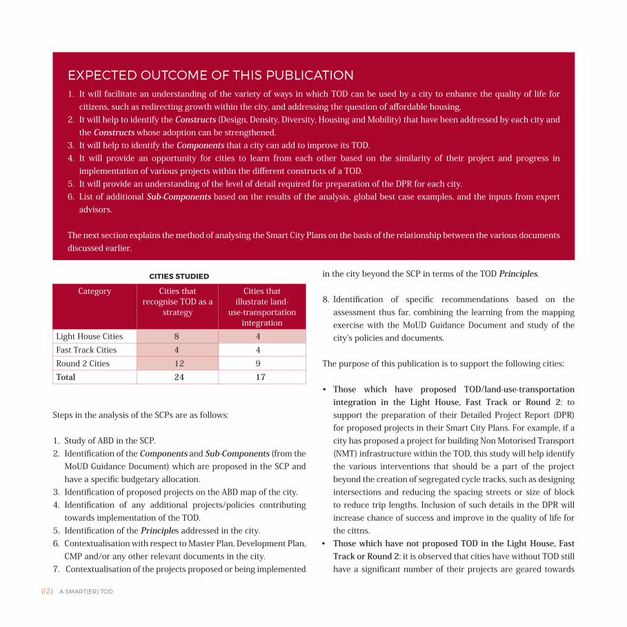
The Guidance Document also enumerates Components and Indicators under the 12 Guiding Principles. The Components are further broken up into Sub-Components. These Sub-Components can be used in the identification of appropriate projects for the city and for the preparation of a Detailed Project Report (DPR) when the Smart City Plan has already been selected.
A SMART(ER) TOD {11}
Transit Oriented Development in Indian Smart Cities — a Global Review of Transportation-Land-Use IntegrationThe document on transportation-land-use Integration provides a theoretical framework for assessing Transit Oriented Development in an Indian Smart City, based on learning from global best practices. It follows the idea of integrating the concept of 3 Ds — Density, Diversity and Design, with Housing and Mobility to create five constructs of a TOD. The document further recommends Principles, Strategies and Interventions under each Construct.
The projects proposed in the Smart City Mission align directly with the Sub-Components listed in the TOD Guidance Document, and the
Strategies proposed in the Global Review align with the Components. This relationship is illustrated in the diagram below.
The Guidance Document derives the Principles, Components and Sub-Components from a study of global best practice examples of TOD design and planning fundamentals, contextualised for application in Indian cities. They are also meant to be revised through further research and implementation experiences. Following the recommendation, this publication suggests some additional Sub-Components in Annexure II based on inputs from expert advisors and national & international best practices
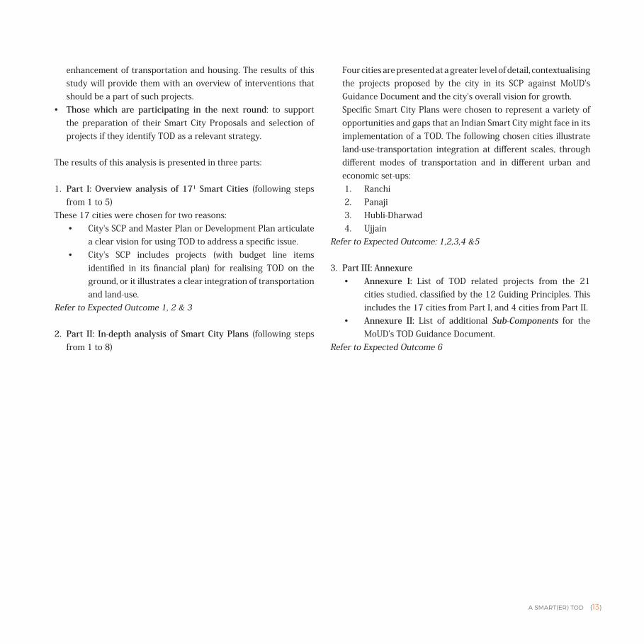
ANALYSING THE SMART CITY PLANSThe extent to which TOD is addressed in an SCP varies across the cities, but it can be broadly categorised into two types: cities that specifically recognise TOD as a strategy, and cities that illustrate land-use-transportation integration. So far, the MoUD has selected 60 cities in the Smart Cities Mission (Light House, Fast Track and Round 2). Among these, 41 have identified TOD or land-use-transportation integration as an approach. The table on the next page shows the classification of these 41 cities. This publication looks at some of the cities from categories highlighted in table. These cities were chosen based on the projects proposed in their SCPs.
TOD PRINCIPLES
MAPPING TOD GUIDANCE DOCUMENT, GLOBAL REVIEW AND SCP
Source: MoUD Guidance Document
{12} A SMART(ER) TOD
Steps in the analysis of the SCPs are as follows:
1. Study of ABD in the SCP.2. Identification of the Components and Sub-Components (from the
MoUD Guidance Document) which are proposed in the SCP and have a specific budgetary allocation.
3. Identification of proposed projects on the ABD map of the city.4. Identification of any additional projects/policies contributing
towards implementation of the TOD. 5. Identification of the Principles addressed in the city. 6. Contextualisation with respect to Master Plan, Development Plan,
CMP and/or any other relevant documents in the city.7. Contextualisation of the projects proposed or being implemented
in the city beyond the SCP in terms of the TOD Principles.
8. Identification of specific recommendations based on the assessment thus far, combining the learning from the mapping exercise with the MoUD Guidance Document and study of the city's policies and documents.
The purpose of this publication is to support the following cities:
• Those which have proposed TOD/land-use-transportation integration in the Light House, Fast Track or Round 2: to support the preparation of their Detailed Project Report (DPR) for proposed projects in their Smart City Plans. For example, if a city has proposed a project for building Non Motorised Transport (NMT) infrastructure within the TOD, this study will help identify the various interventions that should be a part of the project beyond the creation of segregated cycle tracks, such as designing intersections and reducing the spacing streets or size of block to reduce trip lengths. Inclusion of such details in the DPR will increase chance of success and improve in the quality of life for the cittns.
• Those which have not proposed TOD in the Light House, Fast Track or Round 2: it is observed that cities have without TOD still have a significant number of their projects are geared towards
Category Cities that recognise TOD as a
strategy
Cities that illustrate land-
use-transportation integration
Light House Cities 8 4Fast Track Cities 4 4Round 2 Cities 12 9Total 24 17
EXPECTED OUTCOME OF THIS PUBLICATION1. It will facilitate an understanding of the variety of ways in which TOD can be used by a city to enhance the quality of life for
citizens, such as redirecting growth within the city, and addressing the question of affordable housing.2. It will help to identify the Constructs (Design, Density, Diversity, Housing and Mobility) that have been addressed by each city and
the Constructs whose adoption can be strengthened.3. It will help to identify the Components that a city can add to improve its TOD.4. It will provide an opportunity for cities to learn from each other based on the similarity of their project and progress in
implementation of various projects within the different constructs of a TOD.5. It will provide an understanding of the level of detail required for preparation of the DPR for each city.6. List of additional Sub-Components based on the results of the analysis, global best case examples, and the inputs from expert
advisors.
The next section explains the method of analysing the Smart City Plans on the basis of the relationship between the various documents discussed earlier.
CITIES STUDIED
A SMART(ER) TOD {13}
enhancement of transportation and housing. The results of this study will provide them with an overview of interventions that should be a part of such projects.
• Those which are participating in the next round: to support the preparation of their Smart City Proposals and selection of projects if they identify TOD as a relevant strategy.
The results of this analysis is presented in three parts:
1. Part I: Overview analysis of 171 Smart Cities (following steps from 1 to 5)
These 17 cities were chosen for two reasons:• City's SCP and Master Plan or Development Plan articulate
a clear vision for using TOD to address a specific issue.• City's SCP includes projects (with budget line items
identified in its financial plan) for realising TOD on the ground, or it illustrates a clear integration of transportation and land-use.
Refer to Expected Outcome 1, 2 & 3
2. Part II: In-depth analysis of Smart City Plans (following steps from 1 to 8)
Four cities are presented at a greater level of detail, contextualising the projects proposed by the city in its SCP against MoUD's Guidance Document and the city's overall vision for growth.
Specific Smart City Plans were chosen to represent a variety of opportunities and gaps that an Indian Smart City might face in its implementation of a TOD. The following chosen cities illustrate land-use-transportation integration at different scales, through different modes of transportation and in different urban and economic set-ups:1. Ranchi2. Panaji3. Hubli-Dharwad4. Ujjain
Refer to Expected Outcome: 1,2,3,4 &5
3. Part III: Annexure• Annexure I: List of TOD related projects from the 21
cities studied, classified by the 12 Guiding Principles. This includes the 17 cities from Part I, and 4 cities from Part II.
• Annexure II: List of additional Sub-Components for the MoUD's TOD Guidance Document.
Refer to Expected Outcome 6
{14} A SMART(ER) TOD
This overview analysis of 17 Smart Cities focuses on the role of TOD in these cities. Based on an analysis of each city's Master Plan/Development Plan and Smart City Plan, this section discusses how TOD helps improve quality of life for citizens in each of these city. The cities studied in this section are: Gwalior, Bhubaneswar, Bhopal, Ajmer, Thane, Jabalpur, Guwahati, Chandigarh, Chennai, Amritsar, Kochi, Nagpur, Indore, Agra, Faridabad, New Town Kolkata, Ahmedabad.
OVERVIEWThe 17 cities vary in scale, size and modes of transportation. Based on their availability, a review of the Master Plan, Development Plan, Comprehensive Mobility Plan and other relevant documents along with the Smart City Plan for each city is presented in this section.
Key observations from the analysis are:
• All the 17 cities have minimal bus based public transit.• 6 cities have BRT, 8 cities have an additional metro system under
development, 2 cities have an upcoming LRT corridor, and 2 cities have a commuter rail. 1 city also has water-based public transit.
• 16 cities have proposed a retrofit or Greenfield development. The only city that has proposed Greenfield is New Town Kolkata.
• The cities vary in size from 100 sq.km (Chandigarh) to 400 sq.km (Ahmedabad).
• The total investment in ABD varies from ` 876 crore (Nagpur) to ` 5654 crore (Chandigarh).
• The total area under ABD varies from 1.4 sq.km (Bhopal) to 6.92 sq.km (Kochi).
• Percentage of area under ABD with respect to the area of the city varies from 0.5% (Bhopal) to 6% (Kochi).
• Jabalpur, Agra and Ajmer have proposed adoption of TOD principles, but they don't identify public transit corridors or stops within the ABD.
• The variety of issues TOD addresses are:• Re-directing growth for densification within the core
city area; reducing sprawl and improving quality of life; preserving cultural or natural heritage (Gwalior, Bhopal, Bhubaneswar, Guwahati, Chennai, Amritsar).
• Improving access to public transit for low income households through strategic location of slum rehabilitation, affordable housing, and last mile connectivity infrastructure (Thane, Chandigarh, Nagpur, Indore, Agra, Faridabad, Ahmedabad).
• Ensuring sustainable infrastructure service delivery (New Town Kolkata).
• Managing the city's built and open spaces for efficient land utilisation (Ajmer, Jabalpur, Kochi).
Part I OVERVIEW ANALYSIS OF 17 SMART CITIES
A SMART(ER) TOD {15}
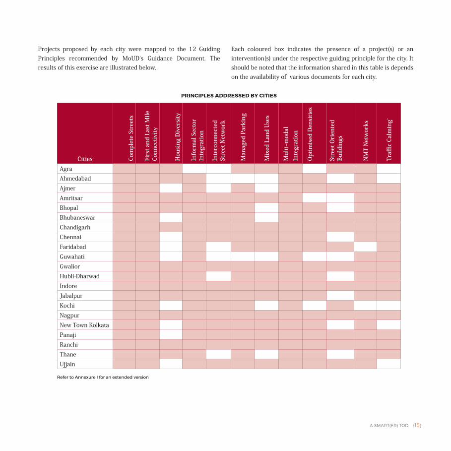
Projects proposed by each city were mapped to the 12 Guiding Principles recommended by MoUD's Guidance Document. The results of this exercise are illustrated below.
Each coloured box indicates the presence of a project(s) or an intervention(s) under the respective guiding principle for the city. It should be noted that the information shared in this table is depends on the availability of various documents for each city.
Cities Com
plet
e St
reet
s
Firs
t and
Las
t Mile
Co
nnec
tivity
Hou
sing
Div
ersi
ty
Info
rmal
Sec
tor
Inte
grat
ion
Inte
rcon
nect
ed
Stre
et N
etw
ork
Man
aged
Par
king
Mix
ed L
and
Use
s
Mul
ti–m
odal
In
tegr
atio
n
Opt
imis
ed D
ensi
ties
Stre
et O
rien
ted
Build
ings
NM
T N
etw
orks
Traffi
c Ca
lmin
g`
AgraAhmedabadAjmerAmritsarBhopalBhubaneswarChandigarhChennaiFaridabadGuwahatiGwaliorHubli-DharwadIndoreJabalpurKochiNagpurNew Town KolkataPanajiRanchiThaneUjjain
PRINCIPLES ADDRESSED BY CITIES
Refer to Annexure I for an extended version
{16} A SMART(ER) TOD
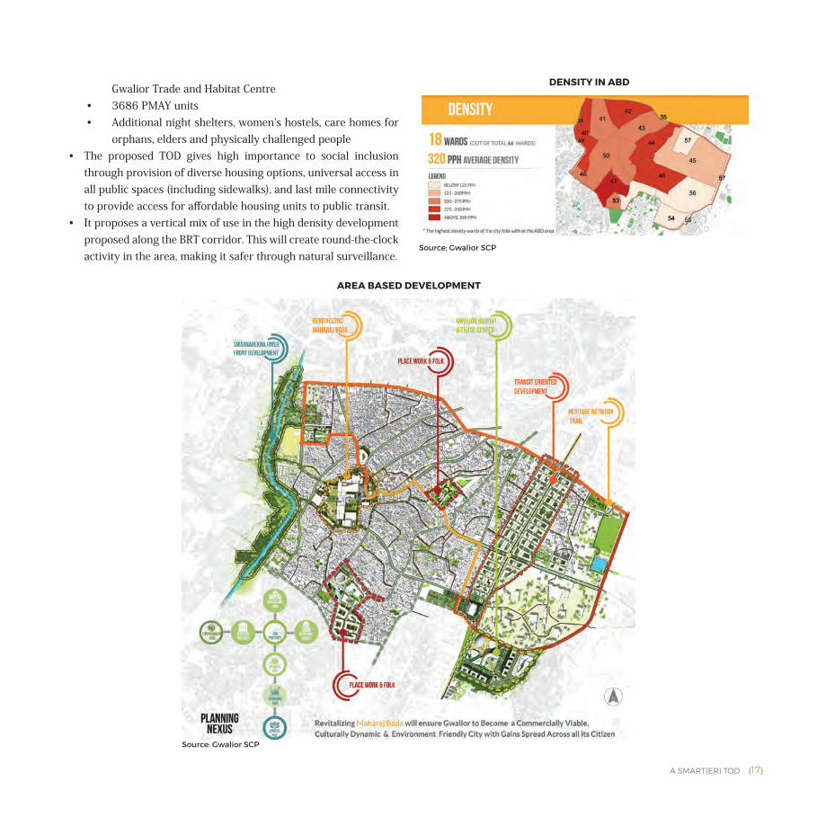
• Gwalior has proposed a 1.65 km BRT corridor-based TOD in an inner city area in its ABD. The ABD includes one of the city's two CBDs — Maharaj Bada. Existing characteristics of the area proposed under the ABD are:• High density but poor infrastructure
(0.77% of city's land for 8.9% of city's population)
• Hub of public transit corridors in the city (bus and IPT)
• Slums on the banks of the Subarnarekha River, which passes through the ABD (15% of city's slum population living on 5% of the ABD's area)
• Home to historical markets, shops
and the local carpet manufacturing industry (>1000 units)
• 45% of commute in the city is by foot and 20% by bicycle; remainder of the trips are by two-wheeler and car.
• FAR will be increased from 1.5 to 3 and sold to developers at premium cost.
• The TOD proposed in the ABD is a clear response to the pressure on the city's infrastructure. It will create a new corridor that is the focus of growth adjacent to the Bada, re-densifying wards with lower density within the ABD. It will also accommodate the slum dwellers already residing in the area proposed for the ABD.
• Employment generators/anchor institutions — Bada, Amkho Bus Stand, Gwalior Habitat and Trade Centre, Jay Arogya Hospital, High Court and MLB College — all are at a distance of 1 km or less from the BRT corridor.
• There is a current shortage of 25,000 housing units in the city (43% of the population lives in slums and 2% of the housing stock is dilapidated). The proposed ABD will accommodate a total of 10,194 housing units within 1 km of the TOD corridor. These units will include:• 1493 affordable housing units • 709 affordable housing units in
GWALIOR
CITY POPULATION
10,54,420
CITY AREA
173.68 sq.km
SLUM POPULATION IN THE CITY
29.38%
AVERAGE HOUSEHOLD SIZE IN THE CITY
5
ABD POPULATION
1,02,883
ABD AREA
3.24 sq.km
ABD BUDGET
` 1916.3 crore
PAN CITY BUDGET
` 334.3 crore
1 sq.km = 100 hectare = 247.1 acre
A SMART(ER) TOD {17}
Gwalior Trade and Habitat Centre• 3686 PMAY units • Additional night shelters, women's hostels, care homes for
orphans, elders and physically challenged people• The proposed TOD gives high importance to social inclusion
through provision of diverse housing options, universal access in all public spaces (including sidewalks), and last mile connectivity to provide access for affordable housing units to public transit.
• It proposes a vertical mix of use in the high density development proposed along the BRT corridor. This will create round-the-clock activity in the area, making it safer through natural surveillance.
AREA BASED DEVELOPMENT
Source: Gwalior SCP
DENSITY IN ABD
Source: Gwalior SCP
{18} A SMART(ER) TOD
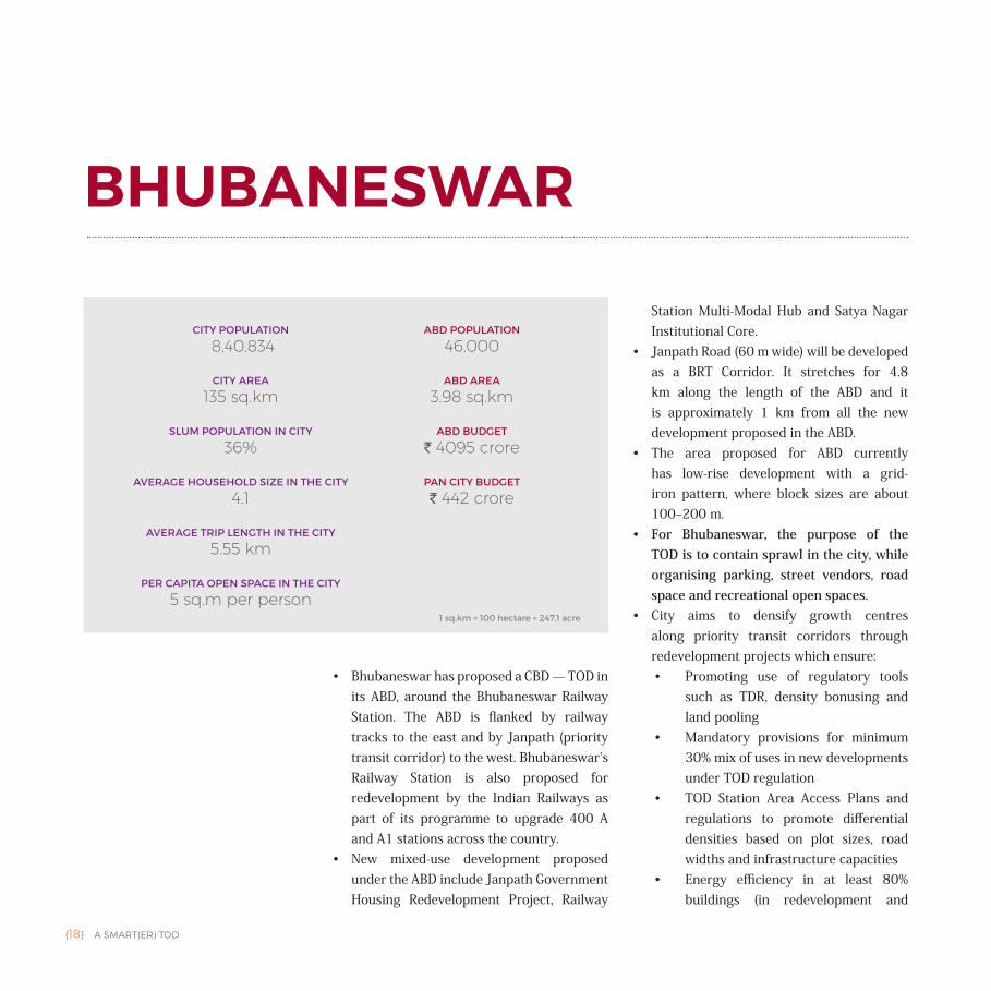
• Bhubaneswar has proposed a CBD — TOD in its ABD, around the Bhubaneswar Railway Station. The ABD is flanked by railway tracks to the east and by Janpath (priority transit corridor) to the west. Bhubaneswar's Railway Station is also proposed for redevelopment by the Indian Railways as part of its programme to upgrade 400 A and A1 stations across the country.
• New mixed-use development proposed under the ABD include Janpath Government Housing Redevelopment Project, Railway
Station Multi-Modal Hub and Satya Nagar Institutional Core.
• Janpath Road (60 m wide) will be developed as a BRT Corridor. It stretches for 4.8 km along the length of the ABD and it is approximately 1 km from all the new development proposed in the ABD.
• The area proposed for ABD currently has low-rise development with a grid-iron pattern, where block sizes are about 100‒200 m.
• For Bhubaneswar, the purpose of the TOD is to contain sprawl in the city, while organising parking, street vendors, road space and recreational open spaces.
• City aims to densify growth centres along priority transit corridors through redevelopment projects which ensure:• Promoting use of regulatory tools
such as TDR, density bonusing and land pooling
• Mandatory provisions for minimum 30% mix of uses in new developments under TOD regulation
• TOD Station Area Access Plans and regulations to promote differential densities based on plot sizes, road widths and infrastructure capacities
• Energy efficiency in at least 80% buildings (in redevelopment and
BHUBANESWAR
CITY POPULATION
8,40,834
CITY AREA
135 sq.km
SLUM POPULATION IN CITY
36%
AVERAGE HOUSEHOLD SIZE IN THE CITY
4.1
AVERAGE TRIP LENGTH IN THE CITY
5.55 km
PER CAPITA OPEN SPACE IN THE CITY
5 sq.m per person
ABD POPULATION
46,000
ABD AREA
3.98 sq.km
ABD BUDGET
` 4095 crore
PAN CITY BUDGET
` 442 crore
1 sq.km = 100 hectare = 247.1 acre
A SMART(ER) TOD {19}
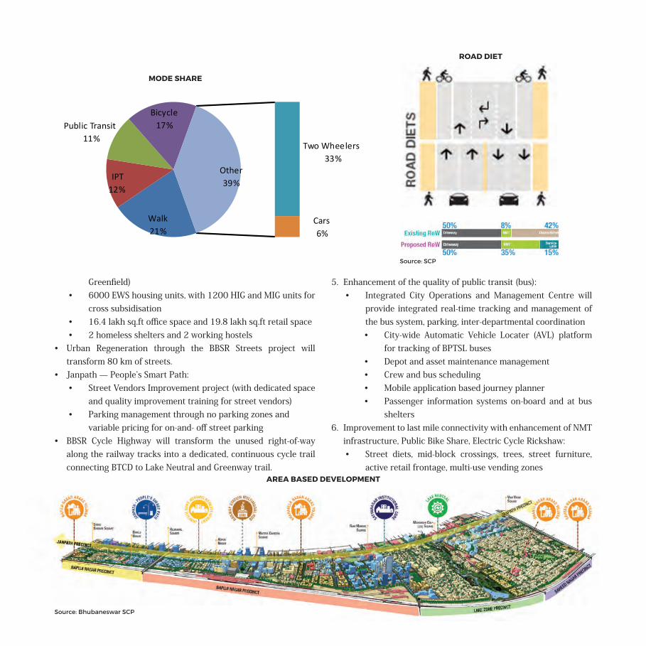
Greenfield) • 6000 EWS housing units, with 1200 HIG and MIG units for
cross subsidisation• 16.4 lakh sq.ft office space and 19.8 lakh sq.ft retail space• 2 homeless shelters and 2 working hostels
• Urban Regeneration through the BBSR Streets project will transform 80 km of streets.
• Janpath — People’s Smart Path: • Street Vendors Improvement project (with dedicated space
and quality improvement training for street vendors)• Parking management through no parking zones and
variable pricing for on-and- off street parking • BBSR Cycle Highway will transform the unused right-of-way
along the railway tracks into a dedicated, continuous cycle trail connecting BTCD to Lake Neutral and Greenway trail.
5. Enhancement of the quality of public transit (bus):• Integrated City Operations and Management Centre will
provide integrated real-time tracking and management of the bus system, parking, inter-departmental coordination• City-wide Automatic Vehicle Locater (AVL) platform
for tracking of BPTSL buses• Depot and asset maintenance management• Crew and bus scheduling• Mobile application based journey planner • Passenger information systems on-board and at bus
shelters6. Improvement to last mile connectivity with enhancement of NMT
infrastructure, Public Bike Share, Electric Cycle Rickshaw:• Street diets, mid-block crossings, trees, street furniture,
active retail frontage, multi-use vending zones
Walk21%
IPT12%
Public Transit11%
Bicycle17%
Two Wheelers33%
Cars6%
Other39%
MODE SHARE
ROAD DIET
Source: SCP
Source: Bhubaneswar SCP
AREA BASED DEVELOPMENT
{20} A SMART(ER) TOD
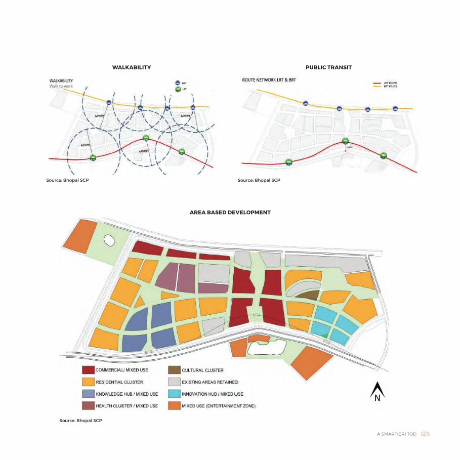
• Bhopal has proposed a mixed-use TOD in Shivaji Nagar area, close to Habibganj Railway Station. The development will have a density of about 323 PPH. LRT corridor proposed in the city runs along the ABD to its south, while the BRT runs along its length on the north.
• Transit stops for both the public transit systems are spaced to ensure that the entire site is within 5-10 minutes walking distance of a public transit stop.
• The TOD is supposed to help mitigate the continuous southwards sprawl that is making infrastructure services
unsustainable, increasing vehicle ownership and congestion.
• The SCP proposes exclusion of all motor vehicles from the site and limits access only to pedestrians and bicycles. The site plan retains some major existing buildings such as JP Hospital and Red Cross Society, which will act as anchor institute for the area.
• The SCP supports mixed-use within the buildings, encouraging round-the-clock activities and ensuring safety through natural surveillance.
• Currently the city has no affordable housing and 35% of its population lives in slums. The ABD will have about 9126 housing units, out of which 15% will be affordable. It will be a mix of public rental, affordable studio apartments and 1 BHK apartments.
• The city aims to advance industry, support local small businesses, leverage the existing educational facilities and promote tourism through the Smart City Plan. The ABD is meant to serve as a catalyst for future growth through the development of various clusters dedicated to knowledge-research, commerce, retail and digital innovation.
• The greatest challenge for Bhopal will be to integrate the ABD and its TOD characteristics into the city's urban fabric and replicate its success beyond the boundaries of the site.
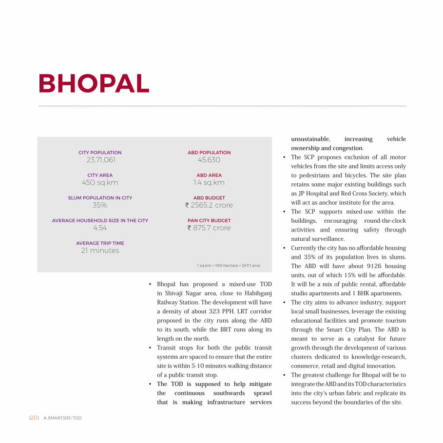
BHOPAL
CITY POPULATION
23,71,061
CITY AREA
450 sq.km
SLUM POPULATION IN CITY
35%
AVERAGE HOUSEHOLD SIZE IN THE CITY
4.54
AVERAGE TRIP TIME
21 minutes
ABD POPULATION
45,630
ABD AREA
1.4 sq.km
ABD BUDGET
` 2565.2 crore
PAN CITY BUDGET
` 875.7 crore
1 sq.km = 100 hectare = 247.1 acre
A SMART(ER) TOD {21}
AREA BASED DEVELOPMENT
WALKABILITY PUBLIC TRANSIT
Source: Bhopal SCP Source: Bhopal SCP
Source: Bhopal SCP
{22} A SMART(ER) TOD
• Ajmer's TOD is a retrofit of a dense inner city area. Purpose of the TOD is to manage the population density in the area and the resulting pressure on infrastructure, to reduce dependence on private vehicles, and increase the use of public transit from the current 40% to 60%.
• Average density of the developed area in the city is 186 PPH.
• Ajmer's strategy, according to the draft of its Development Master Plan, is to leverage the underutilised land parcels in the city. The ABD already has high density and it aims to encourage mixed-use neighbourhoods around transit hubs. The draft Development
Master Plan of Ajmer also lists the variety of uses that can be permissible (after approval) in a given land use.
• Given the existing high density in the area selected for ABD, the proposed TOD focuses on management of open spaces to improve quality of life. This includes reorganisation of street space, protection of the Anasagar Lake, enhancement of public transit, and connectivity between key destinations within the ABD — the railway station and the bus stand. It aims to activate its public spaces and prioritises pedestrians above other users.
• Ajmer is a heritage city and a part of the HRIDAY mission. It is a popular tourist destination and has significant seasonal tourist population. Enhancement of its infrastructure to support this transient population and will improve quality of life for its citizens.
• The city is struggling with chaotic street spaces and has proposed the following to address the issue:• Complete streets• Enhancement of street frontage for
greater transparency• Off-street car parking in 5 places (400
cars in 2 multi-level car parks and 3 surface lots)
AJMER
CITY POPULATION
5,42,321
CITY AREA
55.76 sq.km
SLUM POPULATION IN CITY
14.60%
AVERAGE HOUSEHOLD SIZE IN THE CITY
4.5
ABD POPULATION
91,454
ABD AREA
6.17 sq.km
ABD BUDGET
` 1574 crore
PAN CITY BUDGET
` 196 crore
1 sq.km = 100 hectare = 247.1 acre
A SMART(ER) TOD {23}
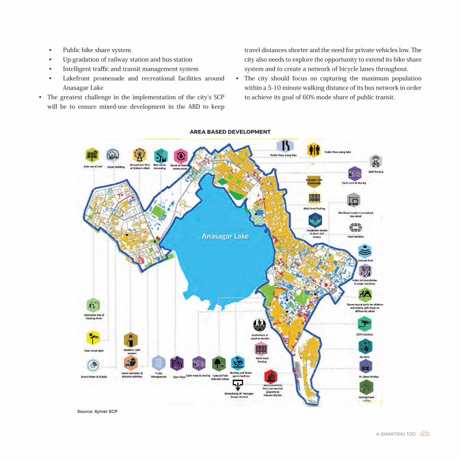
• Public bike share system • Up-gradation of railway station and bus station• Intelligent traffic and transit management system • Lakefront promenade and recreational facilities around
Anasagar Lake• The greatest challenge in the implementation of the city's SCP
will be to ensure mixed-use development in the ABD to keep
travel distances shorter and the need for private vehicles low. The city also needs to explore the opportunity to extend its bike share system and to create a network of bicycle lanes throughout.
• The city should focus on capturing the maximum population within a 5-10 minute walking distance of its bus network in order to achieve its goal of 60% mode share of public transit.
AREA BASED DEVELOPMENT
Source: Ajmer SCP
{24} A SMART(ER) TOD
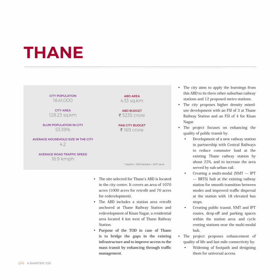
• The site selected for Thane's ABD is located in the city centre. It covers an area of 1070 acres (1000 acres for retrofit and 70 acres for redevelopment).
• The ABD includes a station area retrofit anchored at Thane Railway Station and redevelopment of Kisan Nagar, a residential area located 4 km west of Thane Railway Station.
• Purpose of the TOD in case of Thane is to bridge the gaps in the existing infrastructure and to improve access to the mass transit by enhancing through traffic management.
• The city aims to apply the learnings from this ABD to its three other suburban railway stations and 12 proposed metro stations.
• The city proposes higher density mixed- use development with an FSI of 3 at Thane Railway Station and an FSI of 4 for Kisan Nagar.
• The project focuses on enhancing the quality of public transit by:• Development of a new railway station
in partnership with Central Railways to reduce commuter load at the existing Thane railway station by about 25%, and to increase the area served by sub-urban rail.
• Creating a multi-modal (NMT — IPT — BRTS) hub at the existing railway station for smooth transition between modes and improved traffic dispersal at the station with 18 elevated bus stops.
• Creating public transit, NMT and IPT routes, drop-off and parking spaces within the station area; and cycle renting stations near the multi-modal hub.
• The project proposes enhancement of quality of life and last mile connectivity by: • Widening of footpath and designing
them for universal access.
THANE
CITY POPULATION
18,41,000
CITY AREA
128.23 sq.km
SLUM POPULATION IN CITY
53.39%
AVERAGE HOUSEHOLD SIZE IN THE CITY
4.2
AVERAGE ROAD TRAFFIC SPEED
18.9 kmph
ABD AREA
4.33 sq.km
ABD BUDGET
` 5235 crore
PAN CITY BUDGET
` 169 crore
1 sq.km = 100 hectare = 247.1 acre
A SMART(ER) TOD {25}
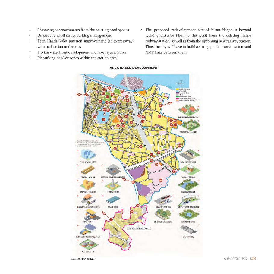
• Removing encroachments from the existing road spaces• On-street and off-street parking management• Teen Haath Naka junction improvement (at expressway)
with pedestrian underpass• 1.5 km waterfront development and lake rejuvenation• Identifying hawker zones within the station area
• The proposed redevelopment site of Kisan Nagar is beyond walking distance (4km to the west) from the existing Thane railway station, as well as from the upcoming new railway station. Thus the city will have to build a strong public transit system and NMT links between them.
AREA BASED DEVELOPMENT
Source: Thane SCP
{26} A SMART(ER) TOD
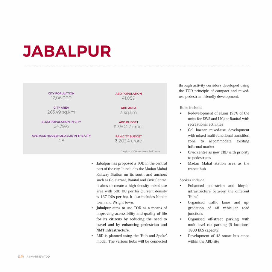
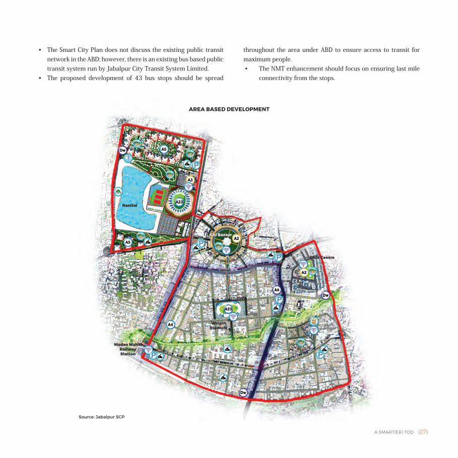
• Jabalpur has proposed a TOD in the central part of the city. It includes the Madan Mahal Railway Station on its south and anchors such as Gol Bazaar, Ranital and Civic Centre. It aims to create a high density mixed-use area with 500 DU per ha (current density is 137 DUs per ha). It also includes Napier town and Wright town.
• Jabalpur aims to use TOD as a means of improving accessibility and quality of life for its citizens by reducing the need to travel and by enhancing pedestrian and NMT infrastructure.
• ABD is planned using the ‘Hub and Spoke’ model. The various hubs will be connected
through activity corridors developed using the TOD principle of compact and mixed-use pedestrian friendly development.
Hubs include:• Redevelopment of slums (55% of the
units for EWS and LIG) at Ranital with recreational activities
• Gol bazaar mixed-use development with mixed multi-functional transition zone to accommodate existing informal market
• Civic centre as new CBD with priority to pedestrians
• Madan Mahal station area as the transit hub
Spokes include• Enhanced pedestrian and bicycle
infrastructure between the different 'Hubs'
• Organised traffic lanes and up-gradation of 48 vehicular road junctions
• Organised off-street parking with multi-level car parking (6 locations; 1800 ECS capacity)
• Development of 43 smart bus stops within the ABD site
JABALPUR
CITY POPULATION
12,06,000
CITY AREA
263.49 sq.km
SLUM POPULATION IN CITY
24.79%
AVERAGE HOUSEHOLD SIZE IN THE CITY
4.8
ABD POPULATION
41,059
ABD AREA
3 sq.km
ABD BUDGET
` 3604.7 crore
PAN CITY BUDGET
` 203.4 crore
1 sq.km = 100 hectare = 247.1 acre
A SMART(ER) TOD {27}
• The Smart City Plan does not discuss the existing public transit network in the ABD; however, there is an existing bus based public transit system run by Jabalpur City Transit System Limited.
• The proposed development of 43 bus stops should be spread
throughout the area under ABD to ensure access to transit for maximum people. • The NMT enhancement should focus on ensuring last mile
connectivity from the stops.
AREA BASED DEVELOPMENT
Source: Jabalpur SCP
Ranital
Gol Bazaar
Wright Stadium
Madan Mahal Railway Station
Civic Centre
{28} A SMART(ER) TOD
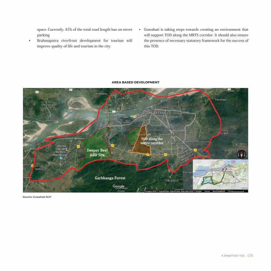
• Guwahati's ABD is a retrofit of 696 acres of connected water bodies in the city. These include the Deepar Beel wetland (Ramsar site), Mora Bharalu stream, Bharalu River, Borsola Beel and the Brahmaputra riverfront.
• A new MRTS line is proposed along the Mora Bharalu channel. The SCP recommends that area within a 500m radius from the station be demarcated as a TOD zone.
• Due to the hilly terrain and frequent flooding, the city has little area for development. Growth in recent years has had an adverse impact on the natural resources, cutting
into the hills, as is evident from the hillside erosion and greater pollution of the natural water bodies in the area.
• The TOD in this city is not just the creation of a dense neighbourhood around the transit station or corridor, but a more nuanced growth management approach that aims to preserve the city's natural resources by redirecting growth to appropriate areas with a high quality of life.
• The projects proposed under the SCP build the environment necessary for development of a TOD. The focus of the ABD is to use the lakes and wetlands as a sustainable tool to mitigate the impact of frequent flash floods in the city instead of its current use for sewerage discharge.
• The proposed projects include:• Enhancing quality of public transit
through establishment of bus lanes, real-time GPS tracking of vehicles, ICT at bus stops and enhanced first and last mile connectivity
• Creating a bicycle-pedestrian infrastructure in the ABD (along water bodies approximately for 18km)
• Creating designated vendors’ zones• Stringent parking policy with ICT
based solutions to reclaim street
GUWAHATI
CITY POPULATION
9,57,352
CITY AREA
219.06 sq.km
SLUM POPULATION IN CITY
2.69%
AVERAGE HOUSEHOLD SIZE IN THE CITY
4.1
AVERAGE TRIP LENGTH
5.8 km
ABD AREA
2.81 sq.km
ABD BUDGET
` 1539 crore
PAN CITY BUDGET
` 622 crore
1 sq.km = 100 hectare = 247.1 acre
A SMART(ER) TOD {29}
space. Currently, 45% of the total road length has on-street parking
• Brahmaputra riverfront development for tourism will improve quality of life and tourism in the city
• Guwahati is taking steps towards creating an environment that will support TOD along the MRTS corridor. It should also ensure the presence of necessary statutory framework for the success of this TOD.
AREA BASED DEVELOPMENT
Source: Guwahati SCP
{30} A SMART(ER) TOD
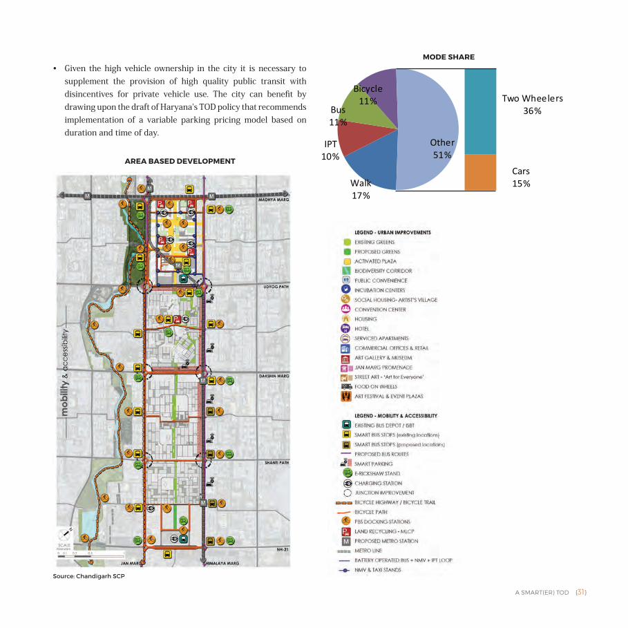
• Chandigarh's TOD focuses on developing employment centres and high quality urban public places in close proximity to public transit while making the city safe for bicycles and pedestrians.
• The TOD proposed in the ABD focuses on low carbon mobility through modal shift from private to public transport as a long term goal for the city. Chandigarh has one of the highest counts of private vehicle ownership in the country, contributing to excessive congestion and high number of traffic accidents. Accident data shows that
the percentage of cyclists among victims has consistently increased from 14.49% to 30.77% (2010‒13).
• Chandigarh's SCP seeks a modal shift towards public transit through improved last mile connectivity.
• The area proposed for ABD in Chandigarh is located in the core city. It is anchored by sector 17 (commercial hub) to the north and sector 43 (proposed mobility hub) to the south and covers sectors 22, 35 and part of 16 and 18.
• Sector 43 will be characterised by compact and mixed-use development that is located within walking and bicycling distance (within the sector) from public transit (metro and bus). It will include:• 4 million sq.m commercial
development within walking or bicycling distance of public transit. (Generation of 30,000 direct employment opportunities — expected new job:new housing ratio of 20).
• Diverse housing options — service apartments, 1500 affordable housing and hostel units for 1200 students and working professionals, within walking distance of metro and ISBT.
CHANDIGARH
CITY POPULATION
9,61,587
CITY AREA
105.68 sq.km
SLUM POPULATION IN CITY
9.89%
AVERAGE HOUSEHOLD SIZE IN THE CITY
4.3
AVERAGE TRIP LENGTH (CAR)
9.6 km
ABD POPULATION
45,000
ABD AREA
5.11 sq.km
ABD BUDGET
` 5654.86 crore
PAN CITY BUDGET
` 235.59 crore
1 sq.km = 100 hectare = 247.1 acre
A SMART(ER) TOD {31}
• Given the high vehicle ownership in the city it is necessary to supplement the provision of high quality public transit with disincentives for private vehicle use. The city can benefit by drawing upon the draft of Haryana's TOD policy that recommends implementation of a variable parking pricing model based on duration and time of day.
MODE SHARE
Walk17%
IPT10%
Bus11%
Bicycle11% Two Wheelers
36%
Cars15%
Other51%
AREA BASED DEVELOPMENT
Source: Chandigarh SCP
{32} A SMART(ER) TOD
• Chennai is among the densest of the smart cities. It is served by multiple modes of mass transit including commuter rail, metro and city buses. Presently, 30% of the trips in the city are on public transport modes and 31% of the trips are by walking or on bicycles.
• The existing urban fabric and form in the city can be categorised as high density with buildings up to a height of 15 m.
• Chennai's ABD is Thyagaraya Nagar, popularly known as T Nagar, a dense commercial mixed-use area in the city. It is one of the principal shopping districts in the city and largest shopping district in India by revenue. T Nagar receives a daily footfall of at least 2,00,00, which goes up to
5,00,000 on weekends.• Although TOD is not identified as a strategy
in the SCP, population densities in the area, its mixed-use fabric and the existing and proposed public transport network lends T Nagar the character of a commercial TOD.
• The city indicates an increase in private vehicle ownership, resulting from poor transit infrastructure. To address this issue, Chennai adopted and implemented a Non-Motorised Transport (NMT) policy in 2014.
• The city aims to increase last mile connectivity by enhancing bicycle and pedestrian infrastructure and building a public bike share system across the city. It also plans to implement vehicle restraint measures within the ABD and provide a feeder bus system for the proposed metro and commuter railway station in the area.
• The NMT infrastructure will be funded by revenue generated by ICT enabled on-street parking management.
• The SCP also emphasises on inclusion with a target of making 80% of the bus-route road network universally accessible.
• The removal of street vendors from the streets in the area should be supported with an appropriate relocation strategy to avoid possible loss of income for informal sector workers.
CHENNAI
CITY POPULATION
46,46,732
CITY AREA
426 sq.km
SLUM POPULATION IN CITY
28.89%
AVERAGE HOUSEHOLD SIZE IN THE CITY
4
ABD POPULATION
2,26,000
ABD AREA
6.95 sq.km
ABD BUDGET
` 878 crore
PAN CITY BUDGET
` 488.3 crore
1 sq.km = 100 hectare = 247.1 acre
A SMART(ER) TOD {33}
• The area selected for ABD is slowly transforming into a single-use area that could lead to eliminating the benefits of round-the-clock activities resulting from its current mixed-use.
• The city has an opportunity to leverage the investment proposed in the ABD to reinforce T Nagar's image as a commercial TOD.
Walk28%
Bicycle13%
IPT2%
Bus29%
Commuter Rail5%
Two Wheelers18%
Cars4%
Others1%
MODE SHARE
AREA BASED DEVELOPMENT
Source: Chennai SCP
{34} A SMART(ER) TOD
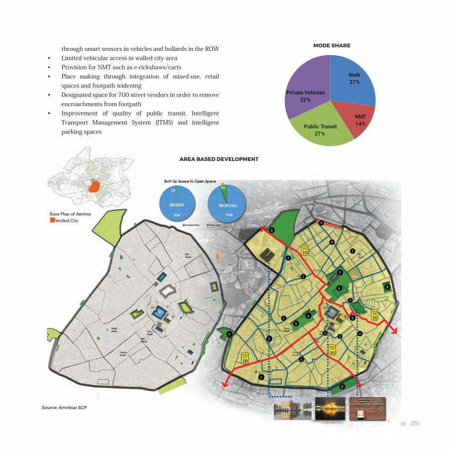
• Amritsar is the home of the Golden Temple, the holiest of Gurdwaras in Sikhism. It has nearly 1 lakh everyday and is located in the walled city, which has been selected as the site for the ABD.
• Covering an area of 950 acres, the walled city acts as a CBD and includes 22 specialised markets or Katras. These are mixed-use residential and commercial units.
• The SCP proposes relocation of activities from an area of 50 acres in the ABD, including Katra Ahluwalia (wholesale cloth) and Majith Mandi (wholesale dry fruits and spices). Its aim to de-densify the walled city
in order to improve the quality of life for its citizens. The relocation will also make the walled city safer, as these markets are a fire hazard in their current situation.
• The area currently occupied by these katras will be replaced with green cover and other social amenities, reducing the density of the area to 300 persons per acre from 380 persons per acre. The green cover of the walled city will increase from 1% to approximately 6%, creating open spaces (60 in number) for use of the public as ‘recreational destinations’.
• The population from the katras will be relocated to a site outside the walled city along the BRT corridor,2 following the principles of TOD, providing affordable housing close to public transit and places of work. Skill based employment and business clusters will be created at the redevelopment site.
• Projects in the ABD also include:• Façade control and refurbishment of
the peripheral wall of walled city • Redevelopment of Town Hall into a
socio-cultural recreational centre• Bicycle and pedestrian infrastructure
with universal access• Pedestrianisation of key routes in the
walled city which will be managed
AMRITSAR
CITY POPULATION
11,32,383
CITY AREA
142 sq.km
SLUM POPULATION IN CITY
29.12%
AVERAGE HOUSEHOLD SIZE IN THE CITY
4.8
AVERAGE TRIP LENGTH
5.71 km
ABD AREA
3.8 sq.km
ABD BUDGET
` 1616.4 crore
PAN CITY BUDGET
` 1814.4 crore
1 sq.km = 100 hectare = 247.1 acre
A SMART(ER) TOD {35}
through smart sensors in vehicles and bollards in the ROW• Limited vehicular access in walled city area• Provision for NMT such as e-rickshaws/carts• Place making through integration of mixed-use, retail
spaces and footpath widening• Designated space for 700 street vendors in order to remove
encroachments from footpath• Improvement of quality of public transit, Intelligent
Transport Management System (ITMS) and intelligent parking spaces
MODE SHARE
Walk27%
NMT14%Public Transit
27%
Private Vehicles32%
AREA BASED DEVELOPMENT
Source: Amritsar SCP
{36} A SMART(ER) TOD
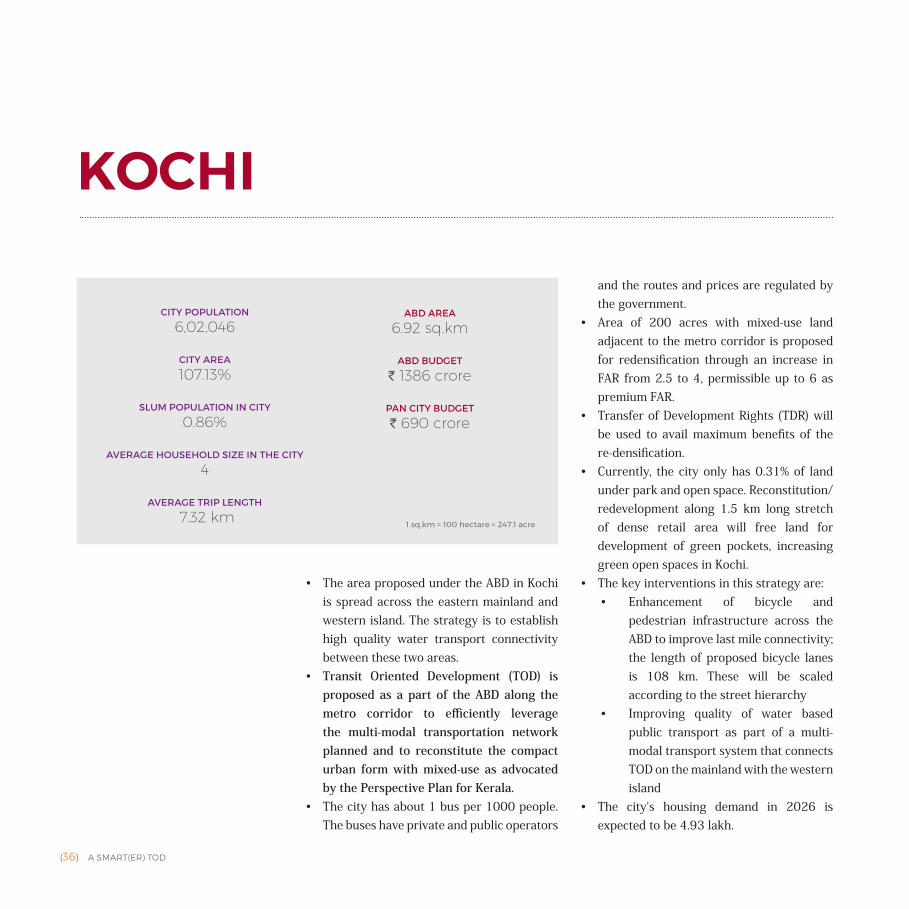
• The area proposed under the ABD in Kochi is spread across the eastern mainland and western island. The strategy is to establish high quality water transport connectivity between these two areas.
• Transit Oriented Development (TOD) is proposed as a part of the ABD along the metro corridor to efficiently leverage the multi-modal transportation network planned and to reconstitute the compact urban form with mixed-use as advocated by the Perspective Plan for Kerala.
• The city has about 1 bus per 1000 people. The buses have private and public operators
and the routes and prices are regulated by the government.
• Area of 200 acres with mixed-use land adjacent to the metro corridor is proposed for redensification through an increase in FAR from 2.5 to 4, permissible up to 6 as premium FAR.
• Transfer of Development Rights (TDR) will be used to avail maximum benefits of the re-densification.
• Currently, the city only has 0.31% of land under park and open space. Reconstitution/redevelopment along 1.5 km long stretch of dense retail area will free land for development of green pockets, increasing green open spaces in Kochi.
• The key interventions in this strategy are:• Enhancement of bicycle and
pedestrian infrastructure across the ABD to improve last mile connectivity; the length of proposed bicycle lanes is 108 km. These will be scaled according to the street hierarchy
• Improving quality of water based public transport as part of a multi-modal transport system that connects TOD on the mainland with the western island
• The city's housing demand in 2026 is expected to be 4.93 lakh.
KOCHI
CITY POPULATION
6,02,046
CITY AREA
107.13%
SLUM POPULATION IN CITY
0.86%
AVERAGE HOUSEHOLD SIZE IN THE CITY
4
AVERAGE TRIP LENGTH
7.32 km
ABD AREA
6.92 sq.km
ABD BUDGET
` 1386 crore
PAN CITY BUDGET
` 690 crore
1 sq.km = 100 hectare = 247.1 acre
A SMART(ER) TOD {37}
• The city has a shortage of affordable housing stock, and the TOD corridor presents a perfect opportunity for fulfilling this need. Yet, the SCP does not identify provision of affordable housing units along this corridor. Further, the rates of residential units along the TOD corridor are higher than that in the city, placing it beyond the financial capacity of lower income households and
risking gentrification of the area. Ironically, the lower income households are the primary users of public transit and depend on it for most of their mobility requirements. Providing housing opportunities for lower income groups and EWS in the TOD corridor would benefit both — the public transit system (in terms of ridership) and these households (in terms of accessibility).
Bus73%
Car15%
Two Wheeler
8%
IPT -AutoRickshaw4%
MODE SHAREAREA BASED DEVELOPMENT
Source: Kochi SCP
{38} A SMART(ER) TOD
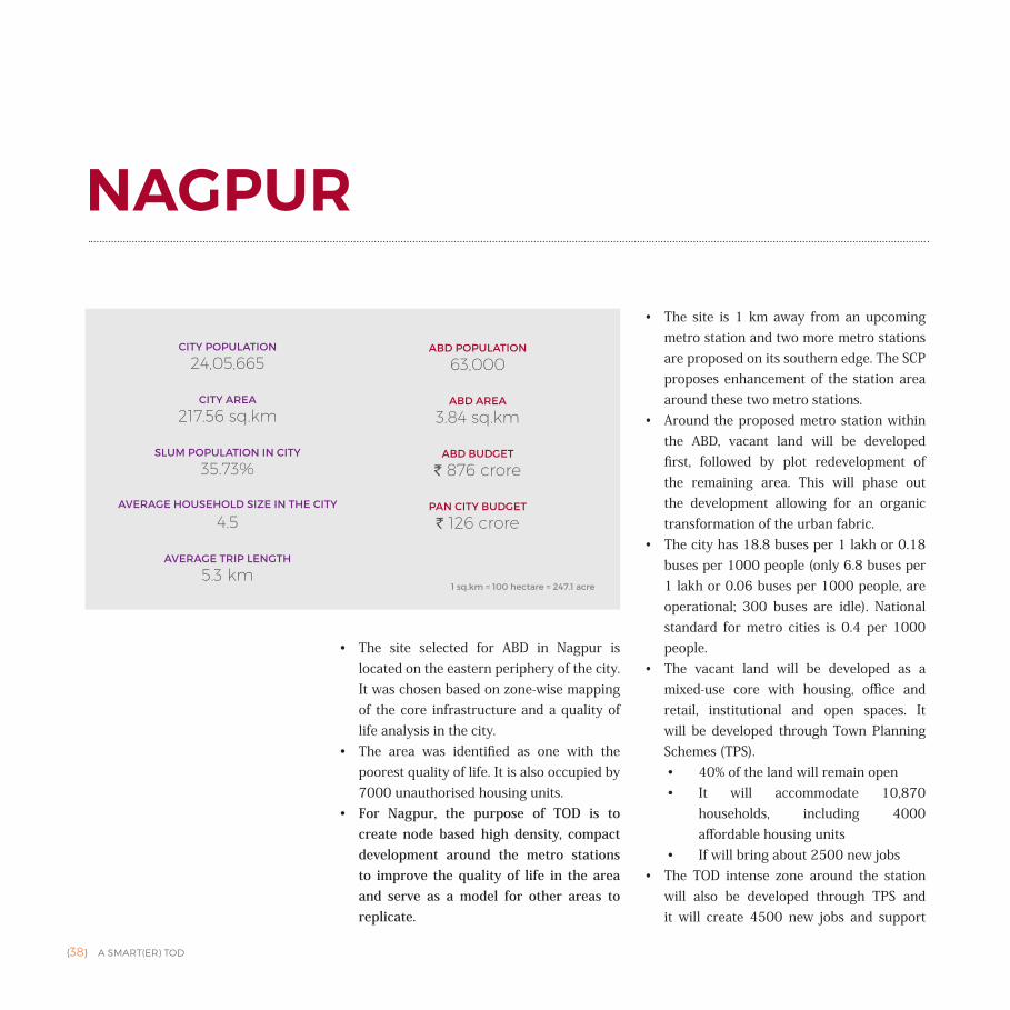
• The site selected for ABD in Nagpur is located on the eastern periphery of the city. It was chosen based on zone-wise mapping of the core infrastructure and a quality of life analysis in the city.
• The area was identified as one with the poorest quality of life. It is also occupied by 7000 unauthorised housing units.
• For Nagpur, the purpose of TOD is to create node based high density, compact development around the metro stations to improve the quality of life in the area and serve as a model for other areas to replicate.
• The site is 1 km away from an upcoming metro station and two more metro stations are proposed on its southern edge. The SCP proposes enhancement of the station area around these two metro stations.
• Around the proposed metro station within the ABD, vacant land will be developed first, followed by plot redevelopment of the remaining area. This will phase out the development allowing for an organic transformation of the urban fabric.
• The city has 18.8 buses per 1 lakh or 0.18 buses per 1000 people (only 6.8 buses per 1 lakh or 0.06 buses per 1000 people, are operational; 300 buses are idle). National standard for metro cities is 0.4 per 1000 people.
• The vacant land will be developed as a mixed-use core with housing, office and retail, institutional and open spaces. It will be developed through Town Planning Schemes (TPS). • 40% of the land will remain open• It will accommodate 10,870
households, including 4000 affordable housing units
• If will bring about 2500 new jobs• The TOD intense zone around the station
will also be developed through TPS and it will create 4500 new jobs and support
NAGPUR
CITY POPULATION
24,05,665
CITY AREA
217.56 sq.km
SLUM POPULATION IN CITY
35.73%
AVERAGE HOUSEHOLD SIZE IN THE CITY
4.5
AVERAGE TRIP LENGTH
5.3 km
ABD POPULATION
63,000
ABD AREA
3.84 sq.km
ABD BUDGET
` 876 crore
PAN CITY BUDGET
` 126 crore
1 sq.km = 100 hectare = 247.1 acre
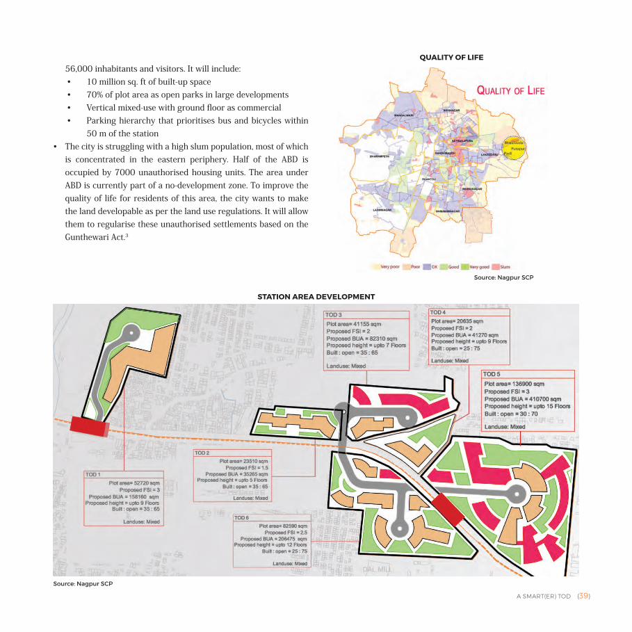
A SMART(ER) TOD {39}
56,000 inhabitants and visitors. It will include:• 10 million sq. ft of built-up space• 70% of plot area as open parks in large developments• Vertical mixed-use with ground floor as commercial • Parking hierarchy that prioritises bus and bicycles within
50 m of the station• The city is struggling with a high slum population, most of which
is concentrated in the eastern periphery. Half of the ABD is occupied by 7000 unauthorised housing units. The area under ABD is currently part of a no-development zone. To improve the quality of life for residents of this area, the city wants to make the land developable as per the land use regulations. It will allow them to regularise these unauthorised settlements based on the Gunthewari Act.3
STATION AREA DEVELOPMENT
QUALITY OF LIFE
Source: Nagpur SCP
Source: Nagpur SCP
{40} A SMART(ER) TOD
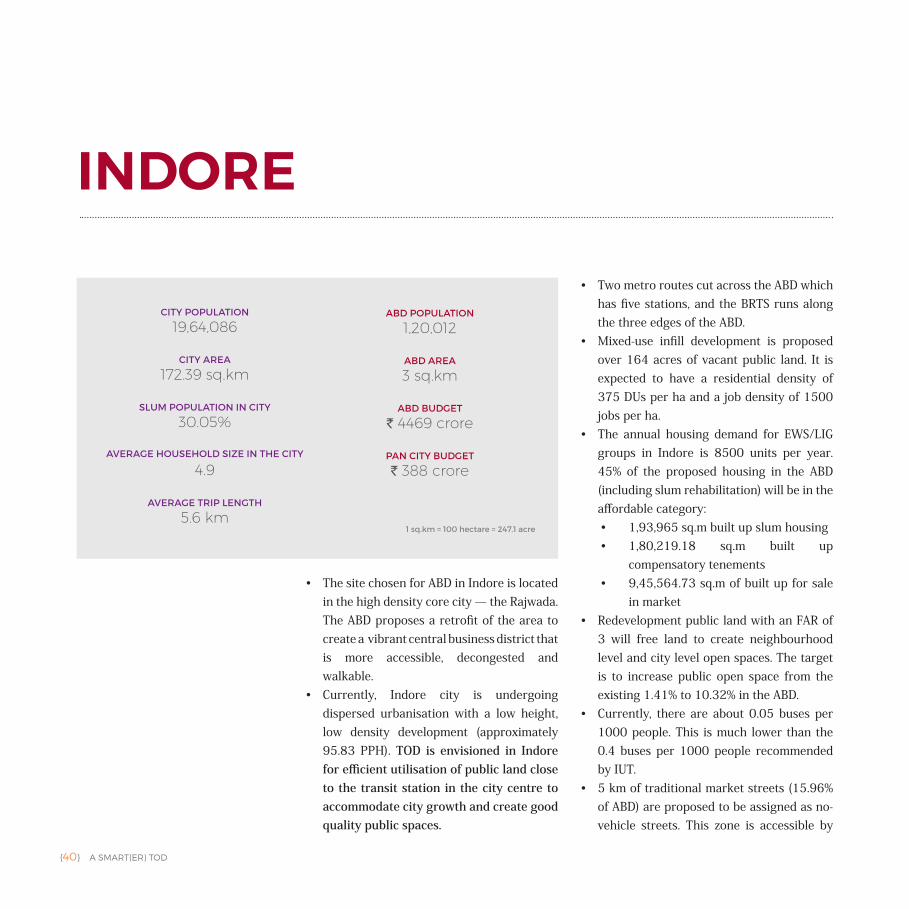
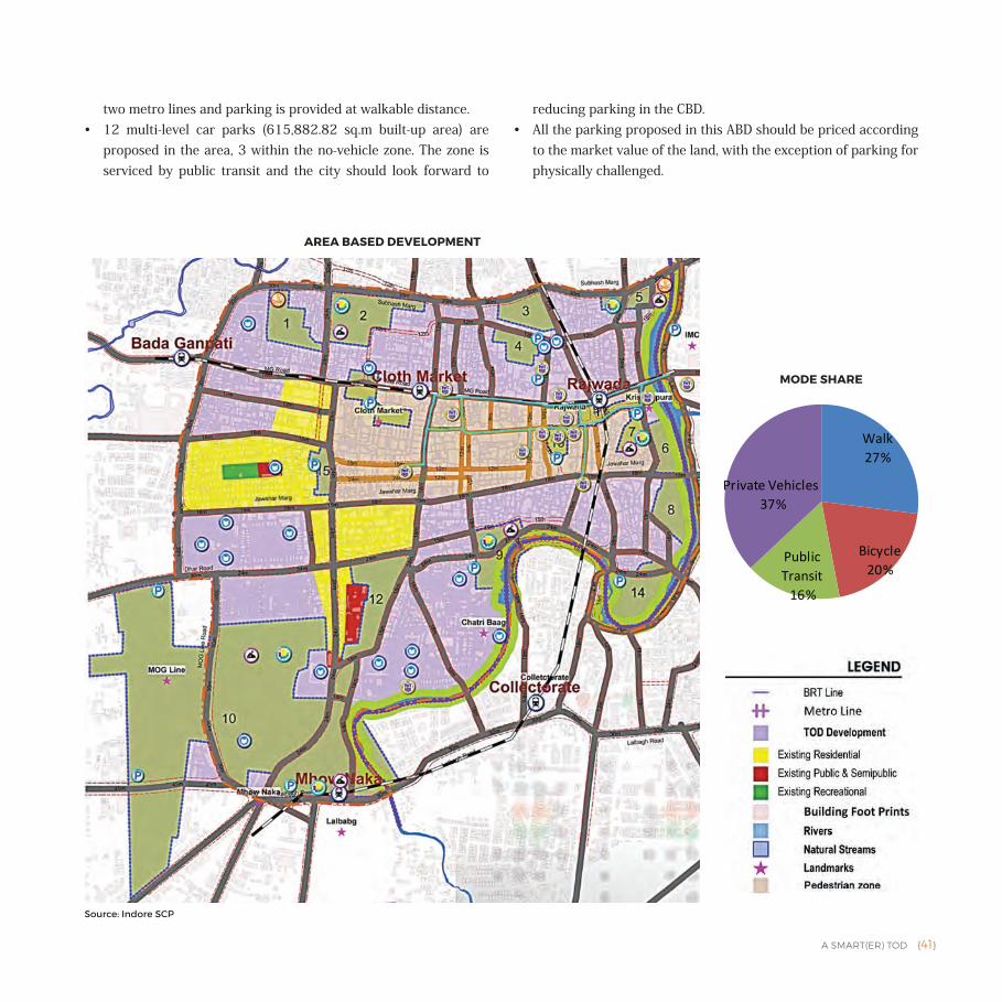
• The site chosen for ABD in Indore is located in the high density core city — the Rajwada. The ABD proposes a retrofit of the area to create a vibrant central business district that is more accessible, decongested and walkable.
• Currently, Indore city is undergoing dispersed urbanisation with a low height, low density development (approximately 95.83 PPH). TOD is envisioned in Indore for efficient utilisation of public land close to the transit station in the city centre to accommodate city growth and create good quality public spaces.
• Two metro routes cut across the ABD which has five stations, and the BRTS runs along the three edges of the ABD.
• Mixed-use infill development is proposed over 164 acres of vacant public land. It is expected to have a residential density of 375 DUs per ha and a job density of 1500 jobs per ha.
• The annual housing demand for EWS/LIG groups in Indore is 8500 units per year. 45% of the proposed housing in the ABD (including slum rehabilitation) will be in the affordable category:• 1,93,965 sq.m built up slum housing• 1,80,219.18 sq.m built up
compensatory tenements• 9,45,564.73 sq.m of built up for sale
in market• Redevelopment public land with an FAR of
3 will free land to create neighbourhood level and city level open spaces. The target is to increase public open space from the existing 1.41% to 10.32% in the ABD.
• Currently, there are about 0.05 buses per 1000 people. This is much lower than the 0.4 buses per 1000 people recommended by IUT.
• 5 km of traditional market streets (15.96% of ABD) are proposed to be assigned as no-vehicle streets. This zone is accessible by
INDORE
CITY POPULATION
19,64,086
CITY AREA
172.39 sq.km
SLUM POPULATION IN CITY
30.05%
AVERAGE HOUSEHOLD SIZE IN THE CITY
4.9
AVERAGE TRIP LENGTH
5.6 km
ABD POPULATION
1,20,012
ABD AREA
3 sq.km
ABD BUDGET
` 4469 crore
PAN CITY BUDGET
` 388 crore
1 sq.km = 100 hectare = 247.1 acre
A SMART(ER) TOD {41}
two metro lines and parking is provided at walkable distance. • 12 multi-level car parks (615,882.82 sq.m built-up area) are
proposed in the area, 3 within the no-vehicle zone. The zone is serviced by public transit and the city should look forward to
reducing parking in the CBD. • All the parking proposed in this ABD should be priced according
to the market value of the land, with the exception of parking for physically challenged.
Walk27%
Bicycle20%
Public Transit
16%
Private Vehicles37%
MODE SHARE
AREA BASED DEVELOPMENT
Source: Indore SCP
{42} A SMART(ER) TOD
• Agra proposes to use TOD to create a compact, high density mixed-use development along the metro corridor; however, its ABD focuses primarily on the improvement of the Fatehabad Road.
• It focuses on retrofitting of 2250 acres of land along the Taj Mahal and area surrounding the inner ring road, forming the Taj Improvement District (TID).
• The area already has mixed land use. Through improvements to transit and slum up-gradation, the city aims to enhance
access to monuments within the city and the experience of visiting the sites. The SCP aims for:• Strengthening public transport and
improving last mile connectivity to increase transit ridership
• Enhancing the public transit system with intelligent bus operations with real-time vehicle tracking
• Up-gradation of 22 slums, façades of 50 houses in proximity to the Taj Mahal, and construction of 250 affordable houses; this number is very low, given that 45% of the city's population lives in slums
• Enhancement of bicycle and pedestrian experience through transportation infrastructure and façade improvement
• Creating defined parking areas for buses/cars/two wheelers, Intermediate Para Transit (IPT) (autos and tempos) and NMT (cycle rickshaws).
• Designated areas for hawkers and roads to have one-way circulation pattern.
AGRA
CITY POPULATION
15,85,704
CITY AREA
120.57 sq.km
SLUM POPULATION IN CITY
44.47%
AVERAGE HOUSEHOLD SIZE IN THE CITY
5.9
AVERAGE TRIP LENGTH
4.9 km
ABD POPULATION
1,46,400
ABD AREA
9.1 sq.km
ABD BUDGET
` 1699 crore
PAN CITY BUDGET
` 434 crore
1 sq.km = 100 hectare = 247.1 acre
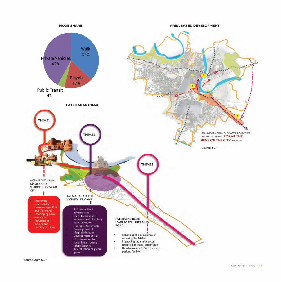
A SMART(ER) TOD {43}
Walk37%
Bicycle17%
Public Transit4%
Private Vehicles42%
MODE SHARE AREA BASED DEVELOPMENT
FATEHABAD ROAD
Source: Agra SCP
Source: SCP
{44} A SMART(ER) TOD
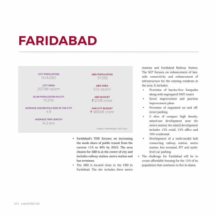
• Faridabad's TOD focuses on increasing the mode share of public transit from the current 11% to 40% by 2025. The area chosen for ABD is at the centre of city and includes railway station, metro station and bus terminus.
• The ABD is located close to the CBD in Faridabad. The site includes three metro
stations and Faridabad Railway Station. The SCP focuses on enhancement of last-mile connectivity and enhancement of infrastructure for the existing residents in the area. It includes:• Provision of barrier-free footpaths
along with segregated NMT routes • Street improvement and junction
improvement plans• Provision of organised on and off-
street parking• 5 sites of compact high density,
mixed-use development near the metro station; the mixed development includes 15% retail, 15% office and 70% residential
• Development of a multi-modal hub connecting railway station, metro station, bus terminal, IPT and multi-level car parking
• The challenge for Faridabad will be to create affordable housing for the 15% of its population that continues to live in slums.
FARIDABAD
CITY POPULATION
14,14,050
CITY AREA
207.88 sq.km
SLUM POPULATION IN CITY
15.21%
AVERAGE HOUSEHOLD SIZE IN THE CITY
4.9
AVERAGE TRIP LENGTH
14.3 km
ABD POPULATION
37,592
ABD AREA
5.12 sq.km
ABD BUDGET
` 2108 crore
PAN CITY BUDGET
` 469.68 crore
1 sq.km = 100 hectare = 247.1 acre
A SMART(ER) TOD {45}
NMT35%
Public Transit
11%
IPT2%
Commuter Rail1%
Private Vehicle51%
MODE SHARE
AREA BASED DEVELOPMENT
PROPOSED TRANSIT ORIENTED DEVELOPMENTZONE IN ABD AREA
Source: Faridabad SCP
Source: Faridabad SCP
{46} A SMART(ER) TOD
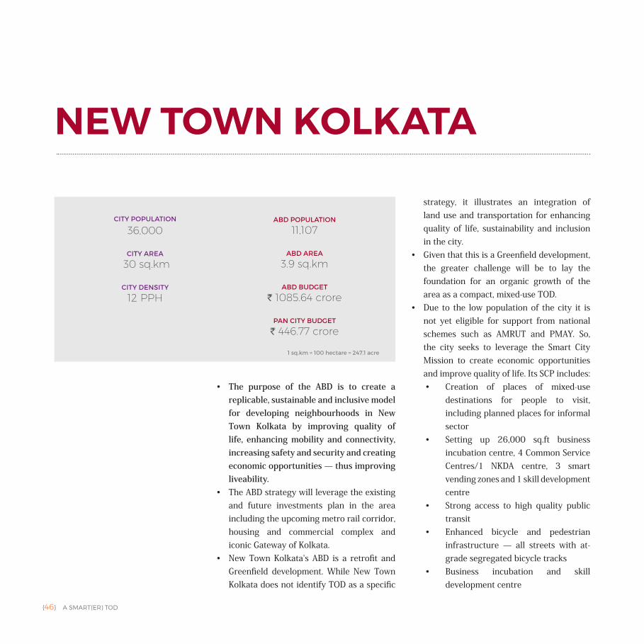
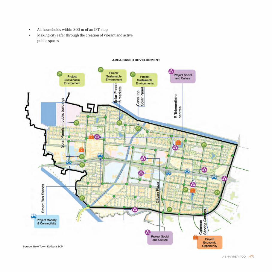
• The purpose of the ABD is to create a replicable, sustainable and inclusive model for developing neighbourhoods in New Town Kolkata by improving quality of life, enhancing mobility and connectivity, increasing safety and security and creating economic opportunities — thus improving liveability.
• The ABD strategy will leverage the existing and future investments plan in the area including the upcoming metro rail corridor, housing and commercial complex and iconic Gateway of Kolkata.
• New Town Kolkata's ABD is a retrofit and Greenfield development. While New Town Kolkata does not identify TOD as a specific
strategy, it illustrates an integration of land use and transportation for enhancing quality of life, sustainability and inclusion in the city.
• Given that this is a Greenfield development, the greater challenge will be to lay the foundation for an organic growth of the area as a compact, mixed-use TOD.
• Due to the low population of the city it is not yet eligible for support from national schemes such as AMRUT and PMAY. So, the city seeks to leverage the Smart City Mission to create economic opportunities and improve quality of life. Its SCP includes:• Creation of places of mixed-use
destinations for people to visit, including planned places for informal sector
• Setting up 26,000 sq.ft business incubation centre, 4 Common Service Centres/1 NKDA centre, 3 smart vending zones and 1 skill development centre
• Strong access to high quality public transit
• Enhanced bicycle and pedestrian infrastructure — all streets with at-grade segregated bicycle tracks
• Business incubation and skill development centre
NEW TOWN KOLKATA
CITY POPULATION
36,000
CITY AREA
30 sq.km
CITY DENSITY
12 PPH
ABD POPULATION
11,107
ABD AREA
3.9 sq.km
ABD BUDGET
` 1085.64 crore
PAN CITY BUDGET
` 446.77 crore
1 sq.km = 100 hectare = 247.1 acre
A SMART(ER) TOD {47}
• All households within 300 m of an IPT stop • Making city safer through the creation of vibrant and active
public spaces
AREA BASED DEVELOPMENT
Source: New Town Kolkata SCP
{48} A SMART(ER) TOD
• Ahmedabad's Smart City Plan builds upon its existing transit infrastructure, leveraging the BRT corridor to develop a Transit Oriented Zone for Wadaj area, where existing slum households will be redeveloped in situ. Its aim is to accommodate the constantly increasing population in the city.
• Redevelopment of the slums in the ABD with strong access to public transit will help increase transit ridership and provide
mobility alternatives to lower income households.
• The projects under ABD include retrofitting of 515 acres of the Transit Oriented Zone (TOZ) and slum redevelopment in 75 acres of land. The area will be developed with the public transit lines acting as its spine, thereby enhancing access to public transport and increasing its ridership. This will include:• 8000 houses in an area of 75 acres
with an FSI of 3, within walking distances of the BRT and metro. These will include 23 to 43 sq.m- sized affordable units for the current slum dwellers in the area.
• Dense development along the proposed TOZ with residential and commercial uses (200 m on either side of the transit corridor).
• Development of an inter-modal hub. • Creation of a defined and compact
urban form.• Densification of existing residential
and commercial development in the Wadaj area to make the projects more sustainable for the city.
• At the pan city level, the city's plans to include a common payment card,
AHMEDABAD
CITY POPULATION
55,77,940
CITY AREA
468.92 sq.km
SLUM POPULATION IN CITY
4.49%
AVERAGE HOUSEHOLD SIZE IN THE CITY
4.7
AVERAGE TRIP LENGTH
4.5 km
ABD AREA
2.38 sq.km
ABD BUDGET
` 1751 crore
PAN CITY BUDGET
` 539 crore
1 sq.km = 100 hectare = 247.1 acre
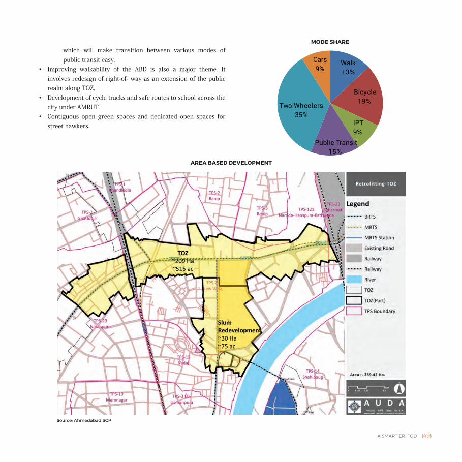
A SMART(ER) TOD {49}
which will make transition between various modes of public transit easy.
• Improving walkability of the ABD is also a major theme. It involves redesign of right-of- way as an extension of the public realm along TOZ.
• Development of cycle tracks and safe routes to school across the city under AMRUT.
• Contiguous open green spaces and dedicated open spaces for street hawkers.
AREA BASED DEVELOPMENT
Walk13%
Bicycle19%
IPT9%
Public Transit15%
Two Wheelers35%
Cars9%
MODE SHARE
Source: Ahmedabad SCP
{50} A SMART(ER) TOD
OVERVIEWThis section presents a detailed analysis of four cities, contextualising the projects proposed by the city in its SCP against the city's overall vision for growth. These four cities illustrate land-use-transportation integration at different scales, through different modes of transportation and in different urban and economic set-ups.
• Ranchi was chosen for its wide variety of projects, its Greenfield ABD, and presence of a larger ecosystem that will foster development of a TOD.
• Panaji was chosen for its non MRT land-use transportation integration, its small size and unique demographic with a high percentage of transient population. It also presents an opportunity of development in an environment that has many restrictions.
• Hubli-Dharwad was chosen due to its integration of the BRT corridor with a railway station that has been identified for redevelopment by the Railways. It is a Brownfield retrofit project.
• Ujjain was chosen for its religious and historic significance. It has proposed a bus based transit system with a Brownfield redevelopment.
The analysis takes into account the available data from the following:• Studies conducted by ITDP and other organisations about the
city's transportation scenario.• Existing legal framework for implementation of projects (CDP,
Master Plan).• Smart City Plans for the City.• Funding for different projects under the SCP and other
government missions.• Other projects underway/proposed in the city.• Collaborations/partnerships with organisations for research/
project implementation support.
Each case presents the city's overall vision for growth, why TOD is an appropriate solution for managing this growth, and how the various policy and project initiatives within the city (in the SCP and beyond), are helping the city achieve this vision. It is done in three parts:a. Policy Framework: Policies, laws, or any associated statutory
documents that will enable or hinder implementation of TOD in the city.
b. Integrated Design: Projects and initiatives geared towards bringing TOD into the Area Based Development proposed in the Smart City Plan. This also includes any additional ongoing
Part II AN IN-DEPTH ANALYSIS OF SMART CITY PLANS
A SMART(ER) TOD {51}
projects in the city that will have affect the functioning of ABD as a TOD.
c. Delivery Mechanism: Tools/mechanisms in place for implementation of the proposed projects. This includes the e-governance reforms proposed under JnNURM, stakeholders (public, non-public) in the city's development, and the status of implementation of the city's SCP projects.
It should be noted that the presentation of each case varies according to the nature and amount of data available. Different scales of jurisdiction for implementation of the SCP are also identified in this discussion:• State Level
• Regional Level• City Level• Site Level (Area Based Development) • Building Level
For each city, three types of information are shared:1. Data from various documents available for the city2. Observations drawn from a comprehensive analysis of the
available documents3. Recommendations specific to the city for successful
implementation of the TOD as their Area Based Development in the SCP.
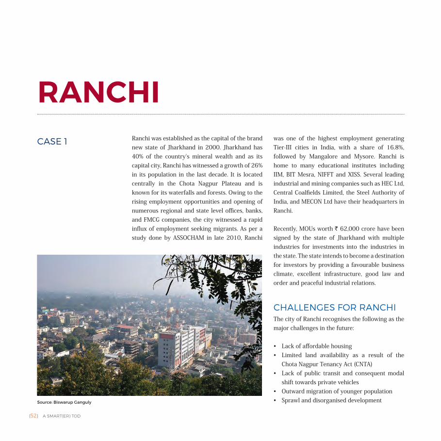
{52} A SMART(ER) TOD
RANCHIRanchi was established as the capital of the brand new state of Jharkhand in 2000. Jharkhand has 40% of the country's mineral wealth and as its capital city, Ranchi has witnessed a growth of 26% in its population in the last decade. It is located centrally in the Chota Nagpur Plateau and is known for its waterfalls and forests. Owing to the rising employment opportunities and opening of numerous regional and state level offices, banks, and FMCG companies, the city witnessed a rapid influx of employment seeking migrants. As per a study done by ASSOCHAM in late 2010, Ranchi
was one of the highest employment generating Tier-III cities in India, with a share of 16.8%, followed by Mangalore and Mysore. Ranchi is home to many educational institutes including IIM, BIT Mesra, NIFFT and XISS. Several leading industrial and mining companies such as HEC Ltd, Central Coalfields Limited, the Steel Authority of India, and MECON Ltd have their headquarters in Ranchi.
Recently, MOUs worth ` 62,000 crore have been signed by the state of Jharkhand with multiple industries for investments into the industries in the state. The state intends to become a destination for investors by providing a favourable business climate, excellent infrastructure, good law and order and peaceful industrial relations.
CHALLENGES FOR RANCHIThe city of Ranchi recognises the following as the major challenges in the future:
• Lack of affordable housing• Limited land availability as a result of the
Chota Nagpur Tenancy Act (CNTA)• Lack of public transit and consequent modal
shift towards private vehicles• Outward migration of younger population• Sprawl and disorganised developmentSource: Biswarup Ganguly
CASE 1
A SMART(ER) TOD {53}
• Increasing vehicle ownership• Managing the growth of gated communities in the periphery of
the city• Accommodating the diverse mode of transportation on the street
PLANNING FOR A SUCCESSFUL TOD IN RANCHI
Ranchi has proposed implementation of a TOD as its Greenfield ABD in its Smart City Plan. TOD is a growth management tool and it must be considered in context of the city's growth and development. For this, it must be considered at the different scales of policy and design within the city. Broadly, these are five:
• State Level: Includes any policies and programmes that give directives, guidelines or recommendations from the State to the ULB.
• Regional Level: Presence of an Urban Metropolitan Transportation Authority (UMTA) can be particularly significant in larger cities or in the case of urban agglomeration. In the case of Ranchi, it has proposed the creation of an UMTA by 2037.
• City Level: Master Plan of a city is one of the most common city scale document guides development in a city. In the case of Ranchi, the city is further divided into:• Zone • Planning Unit
• Site Level (of the Area Based Development): In the context of our study, this is the TOD as proposed within the ABD.
• Building Level: These are mostly regulations working at the building level, including Development Control Regulations (DCR).
RANCHI'S VISIONThe city's vision as stated in the Master Plan 2037 is to become a vibrant capital, where education, health, tourism, information technology and other knowledge based service sectors drive the city's development, economy and quality of life, providing attractive investment opportunities.
The Master Plan also outlines the following goals:
• Establish the city's image as the capital of the state• Establish integrated intra-city transit• Provide affordable housing for all• Streamline the process of development of land• Improve quality of life with the help of social infrastructure• Attract investment for development• Protect cultural, heritage and natural resources of the city
Ranchi's Smart City Plan echoes this vision through the statement: "Ranchi aspires to be a learning and knowledge centre to its citizens, by addressing their socio-economic needs by leveraging its knowledge institution ecosystem."
POLICY FRAMEWORKFor Ranchi, the Policy Framework is primarily comprised of:
1. Jharkhand TOD Policy Draft, 2016 | at State Level2. Ranchi Master Plan, 2037 | at City Level3. Ranchi Smart City Plan | at Site Level & City Level4. Jharkhand Building Bye-laws, 2015 | at State Level & Site Level5. Jharkhand Affordable Housing Policy, 2016 | at State Level
Jharkhand TOD Policy Draft, 2016 was prepared by the Urban Development and Housing Department of the Government of Jharkhand. It will come into force immediately, once approved by the Government of Jharkhand. It shall be applicable to:
• Urban/Regional Development Authorities in Jharkhand• All Municipal Corporations (MCs) and Municipalities in Jharkhand
It will also inform functioning of all departments, corporations and agencies of the Government of Jharkhand at State and city levels. It will supersede the Building Bye-laws and Master Plan.
Ranchi's Master Plan, 2012–2037 was approved by the state of Jharkhand in November 2015. The document was prepared by the Urban Development Department for the Ranchi Municipal Corporation.
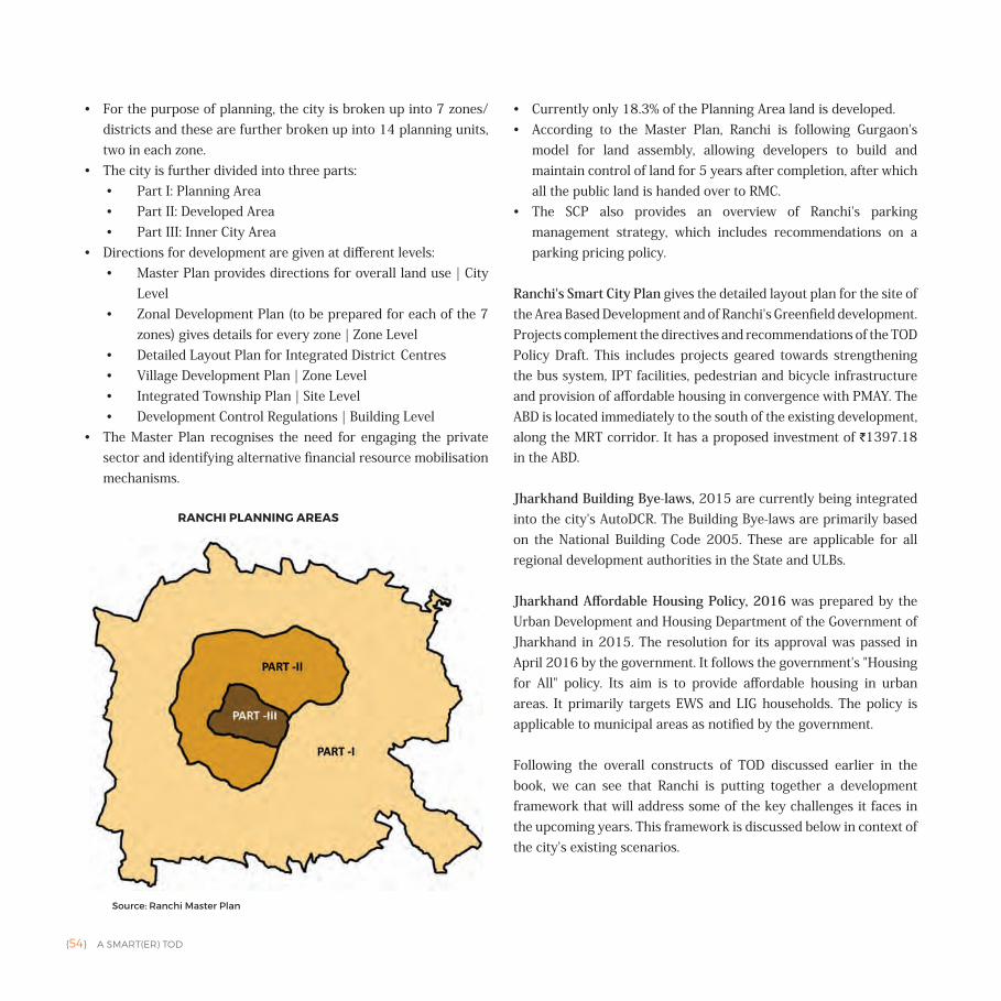
{54} A SMART(ER) TOD
• For the purpose of planning, the city is broken up into 7 zones/districts and these are further broken up into 14 planning units, two in each zone.
• The city is further divided into three parts:• Part I: Planning Area• Part II: Developed Area• Part III: Inner City Area
• Directions for development are given at different levels:• Master Plan provides directions for overall land use | City
Level• Zonal Development Plan (to be prepared for each of the 7
zones) gives details for every zone | Zone Level• Detailed Layout Plan for Integrated District Centres• Village Development Plan | Zone Level• Integrated Township Plan | Site Level• Development Control Regulations | Building Level
• The Master Plan recognises the need for engaging the private sector and identifying alternative financial resource mobilisation mechanisms.
• Currently only 18.3% of the Planning Area land is developed.• According to the Master Plan, Ranchi is following Gurgaon's
model for land assembly, allowing developers to build and maintain control of land for 5 years after completion, after which all the public land is handed over to RMC.
• The SCP also provides an overview of Ranchi's parking management strategy, which includes recommendations on a parking pricing policy.
Ranchi's Smart City Plan gives the detailed layout plan for the site of the Area Based Development and of Ranchi's Greenfield development. Projects complement the directives and recommendations of the TOD Policy Draft. This includes projects geared towards strengthening the bus system, IPT facilities, pedestrian and bicycle infrastructure and provision of affordable housing in convergence with PMAY. The ABD is located immediately to the south of the existing development, along the MRT corridor. It has a proposed investment of `1397.18 in the ABD.
Jharkhand Building Bye-laws, 2015 are currently being integrated into the city's AutoDCR. The Building Bye-laws are primarily based on the National Building Code 2005. These are applicable for all regional development authorities in the State and ULBs.
Jharkhand Affordable Housing Policy, 2016 was prepared by the Urban Development and Housing Department of the Government of Jharkhand in 2015. The resolution for its approval was passed in April 2016 by the government. It follows the government's "Housing for All" policy. Its aim is to provide affordable housing in urban areas. It primarily targets EWS and LIG households. The policy is applicable to municipal areas as notified by the government.
Following the overall constructs of TOD discussed earlier in the book, we can see that Ranchi is putting together a development framework that will address some of the key challenges it faces in the upcoming years. This framework is discussed below in context of the city's existing scenarios.
RANCHI PLANNING AREAS
Source: Ranchi Master Plan
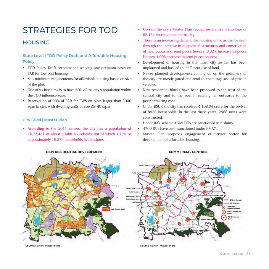
A SMART(ER) TOD {55}
STRATEGIES FOR TODHOUSING
State Level | TOD Policy Draft and Affordable Housing Policy
• TOD Policy Draft recommends waiving any premium costs on FAR for low-cost housing.
• Sets minimum requirements for affordable housing based on size of the plot.
• One of its key aims is to have 60% of the city's population within the TOD influence zone.
• Reservation of 20% of FAR for EWS on plots larger than 2000 sq.m in size, with dwelling units of size 25‒40 sq.m.
City Level | Master Plan
• According to the 2011 census, the city has a population of 10,73,427 or about 2 lakh households, out of which 7.72% or approximately 16,573 households live in slums.
• Overall, the city's Master Plan recognises a current shortage of 88,434 housing units in the city.
• There is an increasing demand for housing units, as can be seen through the increase in dilapidated structures and construction of new pucca and semi-pucca houses (3.32% increase in pucca Houses; 1.09% increase in semi-pucca houses).
• Development of housing in the inner city so far has been unplanned and has led to inefficient use of land.
• Newer planned developments coming up on the periphery of the city are mostly gated and tend to encourage use of private vehicles.
• New residential blocks have been proposed to the west of the central city and to the south, reaching far outwards to the peripheral ring road.
• Under BSUP, the city has received ` 108.64 crore for the revival of 8928 households. In the last three years, 2588 units were constructed.
• Under RAY scheme 1565 DUs are sanctioned in 5 slums. • 4700 DUs have been sanctioned under PMAY. • Master Plan proposes engagement of private sector for
development of affordable housing.
NEW RESIDENTIAL DEVELOPMENT COMMERCIAL CENTRES
Source: Ranchi Master Plan Source: Ranchi Master Plan
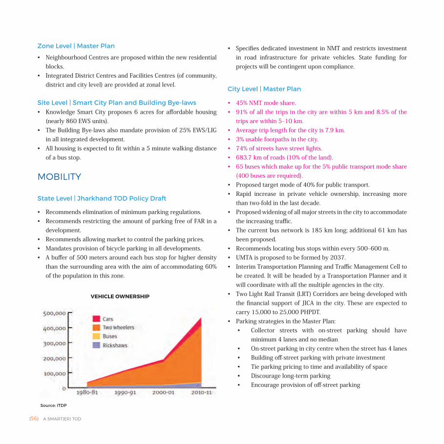
{56} A SMART(ER) TOD
Zone Level | Master Plan
• Neighbourhood Centres are proposed within the new residential blocks.
• Integrated District Centres and Facilities Centres (of community, district and city level) are provided at zonal level.
Site Level | Smart City Plan and Building Bye-laws• Knowledge Smart City proposes 6 acres for affordable housing
(nearly 860 EWS units).• The Building Bye-laws also mandate provision of 25% EWS/LIG
in all integrated development.• All housing is expected to fit within a 5 minute walking distance
of a bus stop.
MOBILITY
State Level | Jharkhand TOD Policy Draft
• Recommends elimination of minimum parking regulations.• Recommends restricting the amount of parking free of FAR in a
development.• Recommends allowing market to control the parking prices.• Mandates provision of bicycle parking in all developments.• A buffer of 500 meters around each bus stop for higher density
than the surrounding area with the aim of accommodating 60% of the population in this zone.
• Specifies dedicated investment in NMT and restricts investment in road infrastructure for private vehicles. State funding for projects will be contingent upon compliance.
City Level | Master Plan
• 45% NMT mode share.• 91% of all the trips in the city are within 5 km and 8.5% of the
trips are within 5‒10 km. • Average trip length for the city is 7.9 km. • 3% usable footpaths in the city. • 74% of streets have street lights.• 683.7 km of roads (10% of the land).• 65 buses which make up for the 5% public transport mode share
(400 buses are required).• Proposed target mode of 40% for public transport.• Rapid increase in private vehicle ownership, increasing more
than two-fold in the last decade.• Proposed widening of all major streets in the city to accommodate
the increasing traffic. • The current bus network is 185 km long; additional 61 km has
been proposed.• Recommends locating bus stops within every 500‒600 m. • UMTA is proposed to be formed by 2037.• Interim Transportation Planning and Traffic Management Cell to
be created. It will be headed by a Transportation Planner and it will coordinate with all the multiple agencies in the city.
• Two Light Rail Transit (LRT) Corridors are being developed with the financial support of JICA in the city. These are expected to carry 15,000 to 25,000 PHPDT.
• Parking strategies in the Master Plan:• Collector streets with on-street parking should have
minimum 4 lanes and no median • On-street parking in city centre when the street has 4 lanes• Building off-street parking with private investment• Tie parking pricing to time and availability of space• Discourage long-term parking• Encourage provision of off-street parking
VEHICLE OWNERSHIP
Source: ITDP
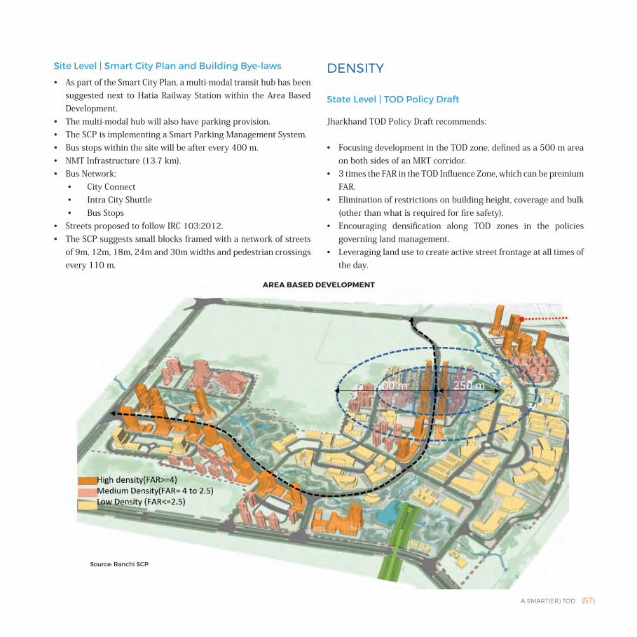
A SMART(ER) TOD {57}
Site Level | Smart City Plan and Building Bye-laws
• As part of the Smart City Plan, a multi-modal transit hub has been suggested next to Hatia Railway Station within the Area Based Development.
• The multi-modal hub will also have parking provision.• The SCP is implementing a Smart Parking Management System.• Bus stops within the site will be after every 400 m.• NMT Infrastructure (13.7 km).• Bus Network:
• City Connect• Intra City Shuttle• Bus Stops
• Streets proposed to follow IRC 103:2012.• The SCP suggests small blocks framed with a network of streets
of 9m, 12m, 18m, 24m and 30m widths and pedestrian crossings every 110 m.
DENSITY
State Level | TOD Policy Draft
Jharkhand TOD Policy Draft recommends:
• Focusing development in the TOD zone, defined as a 500 m area on both sides of an MRT corridor.
• 3 times the FAR in the TOD Influence Zone, which can be premium FAR.
• Elimination of restrictions on building height, coverage and bulk (other than what is required for fire safety).
• Encouraging densification along TOD zones in the policies governing land management.
• Leveraging land use to create active street frontage at all times of the day.
AREA BASED DEVELOPMENT
Source: Ranchi SCP
{58} A SMART(ER) TOD
• Elimination of minimum roadside set-backs.• Tying building permits to comply with urban design guidelines.
City Level | Master Plan
• The city's population has increased by 27% in the last decade, however its area has reduced by 2 sq.km, indicating increase of 80% in its overall density.
• It has a current gross residential density of 129 PPH.• The city's land is fragmented as a result of the CNTA, restricting
opportunities of large-scale development.• It has also resulted in pockets of unused land within the city.
Site Level | Smart City Plan and Building Bye-laws
• Jharkhand Building Bye-laws provide regulations for ensuring universal access. They also address designing spaces for children. They provide directions for the design of:• Access paths/walkways• Parking• Building Design
• Building Bye-laws tie road width to the FAR. • High density mixed-use development is proposed along the main
trunk road within the site.• FAR proposed within the site:
• High density = greater than 4• Medium density = 2.5 to 4• Low density = 2.5
DIVERSITY
State Level| TOD Policy Draft
• Recommends using Land Use Plans and DCRs to encourage re-zoning of land within TOD zones to mixed-use with residential or commercial development.
• Mandates provision of a second land use after 85% of residential use on sites larger than 2000 sq.m in size.
• Recommends planning for creation of employment centres in future within TOD zones.
City Level | Master Plan• Main streets and corridors in the city have mixed-use with
commercial activities along the street on the ground level.• According to the Master Plan new residential development has
been proposed along the city's peripheral ring road.• It also recognises areas of "composite use" where residential,
commercial, semi-public, public and recreational uses will coexist. These areas are surrounded by residential areas. They are proposed as integrated district centres, social facilities centre, etc.
• There is very little composite use proposed along the LRT Corridor.
• Zonal Development Plans are to be prepared for further details of areas within the city.
Zone Level | Master Plan
• Integrated District Centres and Facility Centres are provided in each zone.
Site Level | Smart City Plan and Building Bye-laws
• High density mixed land use development is focused around the trunk road in the city.
• Other land uses are spread over the remainder of the site and segregated by blocks.
DESIGN
State Level | TOD Policy Draft
• Inclusion of street design guidelines that comprehensively outline the means of expanding and improving NMT facilities, public spaces and travel demand management.
• Inclusion of urban design guidelines to develop a built form that complements sustainable transport modes and supports creation of safe public spaces.
• Jharkhand Building Bye-laws were published in 2015. These apply to all building activities within ULBs and Regional Development Authorities.
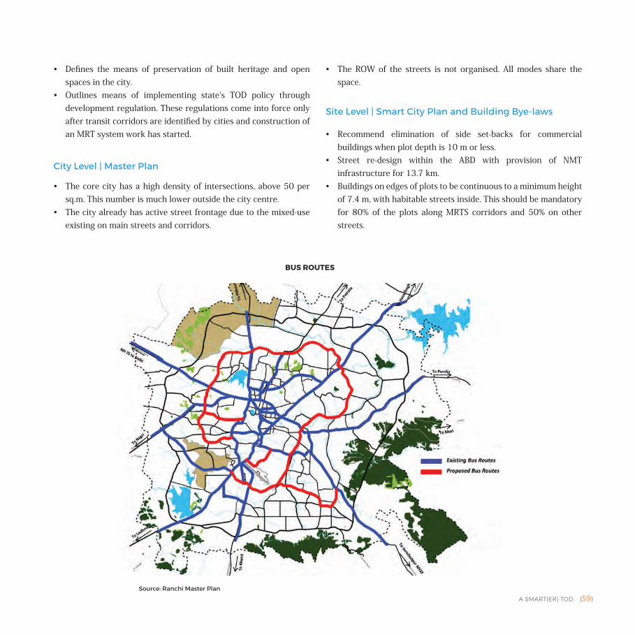
A SMART(ER) TOD {59}
• Defines the means of preservation of built heritage and open spaces in the city.
• Outlines means of implementing state's TOD policy through development regulation. These regulations come into force only after transit corridors are identified by cities and construction of an MRT system work has started.
City Level | Master Plan
• The core city has a high density of intersections, above 50 per sq.m. This number is much lower outside the city centre.
• The city already has active street frontage due to the mixed-use existing on main streets and corridors.
• The ROW of the streets is not organised. All modes share the space.
Site Level | Smart City Plan and Building Bye-laws
• Recommend elimination of side set-backs for commercial buildings when plot depth is 10 m or less.
• Street re-design within the ABD with provision of NMT infrastructure for 13.7 km.
• Buildings on edges of plots to be continuous to a minimum height of 7.4 m, with habitable streets inside. This should be mandatory for 80% of the plots along MRTS corridors and 50% on other streets.
BUS ROUTES
Source: Ranchi Master Plan
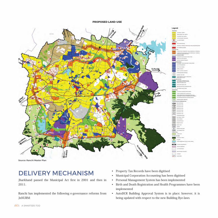
{60} A SMART(ER) TOD
PROPOSED LAND-USE
DELIVERY MECHANISMJharkhand passed the Municipal Act first in 2001 and then in 2011.
Ranchi has implemented the following e-governance reforms from JnNURM:
• Property Tax Records have been digitised• Municipal Corporation Accounting has been digitised• Personal Management System has been implemented• Birth and Death Registration and Health Programmes have been
implemented• AutoDCR Building Approval System is in place; however, it is
being updated with respect to the new Building Bye-laws
Source: Ranchi Master Plan
A SMART(ER) TOD {61}
The SPV includes representatives from:
• Urban Development and Housing Department• Ranchi Municipal Corporation• State Urban Development Agency• Jharkhand Vidyut Vitran Nigam Limited• Jharkhand Police
The city recognises convergence with the following bodies as stakeholders for implementation of its SCP:
• Jharkhand Vidyut Vitaran Nigam Limited• Jharkhand Renewable Energy Development Department• Drinking Water Supply and Sanitation Department• Jharkhand Police, Jharkhand Police (Traffic)• Transport Department: RTA, Urban Development & Housing
Department, GoJ• Jharkhand Pollution Control Board• Developer • Academic Institutions like AMITY, AMRITA, Symbiosis, G.N.SINHA• Vendors• Contractors
Resources for SCP
• Government of India (GoI) under SCM/RMC Equity• Equity from Government of Jharkhand• Convergence with Grants from GoI/GoJ• Atal Mission for Rejuvenation and Urban Transformation (AMRUT)• Pradhaan Mantri Awas Yojana (PMAY) under Housing For All
(HFA) Mission• Swachh Bharat Mission (SBM)• Solar City Scheme of Ministry of New & Renewable Energy• World Bank under JSUDP Project
RRDA, RIADA, HEC are not seen among the stakeholders.
CITY'S APPROACH TOWARDS TODIn summary, the city's approach focuses on:
• Create infrastructure to support the existing NMT mode share and to limit the growth in private vehicle use.
• Within its SCP, the city has proposed a rich network of bus routes in the ABD, capturing 100% of the population within a 5-minute walking distance of a bus stop.
• In addition to the proposed 13.7 km of infrastructure improvement for NMT and proposed smaller block size, the city has the opportunity to create a dense network of pedestrian and bicycle paths in addition to the street grid.
• The MRT corridor cuts through the city north-east to south-west. The proposed land use in the Master Plan only indicates a high density residential along the corridor and diversity of land use is not evident. If the area along MRT corridors is not developed with a variety of uses that reduce the need to travel, the dependence on private vehicles will not reduce. The city needs to align mixed-use with MRT corridors at the city level in addition to high residential density.
• Create a diverse and resilient transportation system in the city.
• The city has three different modes of public transit: railway, light rail and bus.
• The SCP proposes a robust bus network within the ABD. But, the bus routes proposed in the Master Plan (beyond the ABD) don't connect the areas where the new residential development is proposed along the ring road, neither does it serve all the areas with "composite" or mixed-use.
• There is a significant focus on widening the streets as compared to construction of new streets. Moving away from the centre of the city, the street network grows sparse (as observed in a study conducted by ITDP). The city needs to focus on densifying its street network to shorten trip
{62} A SMART(ER) TOD
lengths, reduce congestion and to increase walkability. The SCP adds streets of width 9 m and 12 m along with the others proposed in the Master Plan (ranging from 15 m to 60 m).
• Promote urban planning practices that match density to transit capacity while also promoting intense mixed-use in such development.
• Despite its strong advocacy of mixed-uses close to transit, the city's Master Plan places most of the "composite" land uses along the ring corridor, without direct access to the bus network or proposed LRT.
• At the ABD level, it can be seen that the mixed-use only exists along the trunk road in the site; however the remainder of the site is segregated by blocks. This is also observed at the city level. There is a need to integrate "composite" land use into the fabric of the city to bring more activity to the streets around the clock although this already exists in many streets in the form of ground floor commercial activity with a secondary use on other floors.
• Promote Compact Growth• The city recognises that it has three types of development
opportunities: infill in the inner city; redevelopment of vacant land in the area around the inner city; unused land in the outer city. If these three parts are developed through organised phasing, the city will be able to keep its growth compact.
• Promote active street life through building design • The city has proposed active frontages, transparent
boundary walls and other regulations for an active street; however, all these efforts won't be effective where land uses
are segregated, as can be seen in the ABD (by blocks) and at the city level (where residential land uses are mostly separate from mixed-uses).
• The city needs to encourage activity generating uses at the street level through its zonal development plan.
• Develop diverse employment centres• The city has proposed a variety of job centres through
its SCP and a variety of job centres are already located in proximity of the ABD; however, it is important to ensure public transit connectivity between these job centres and nearby residential developments.
• Provide affordable housing• The city has a significant shortage in its housing stock
(88,434 units). It is proposing affordable housing units through PMAY, RAY and BSUP. Within the SCP, it has proposed 860 affordable housing units in the ABD. It will be useful to recognise diversity within these units in terms of size, number of rooms and tenure.
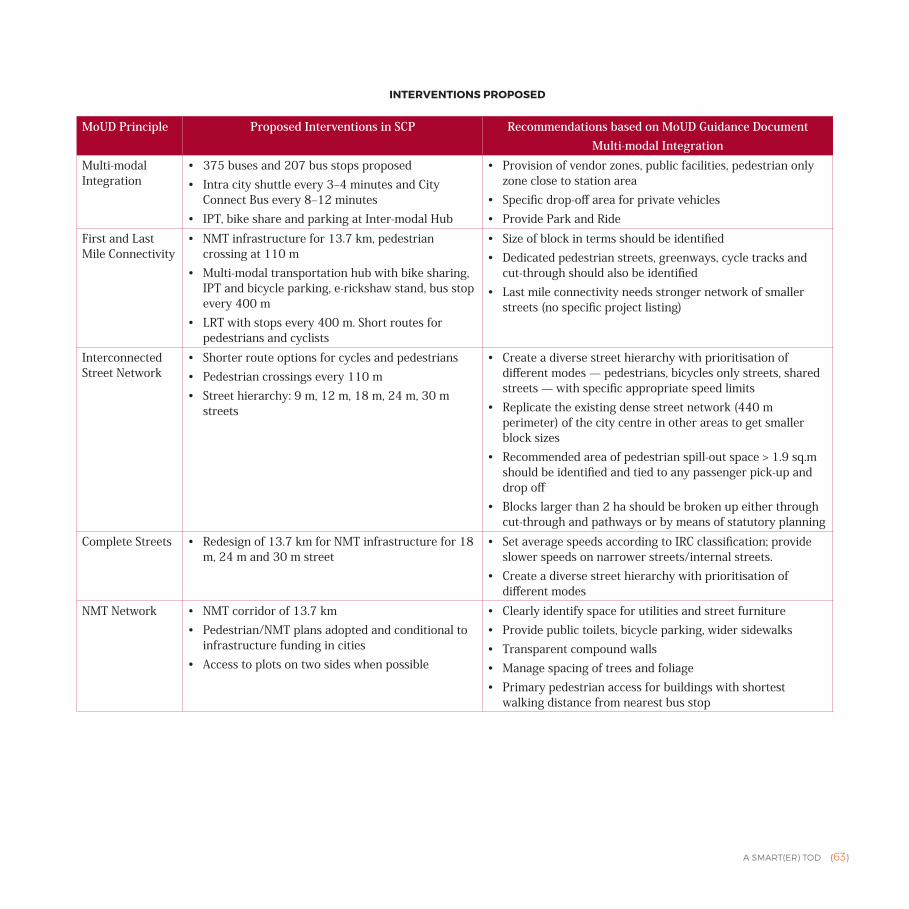
A SMART(ER) TOD {63}
MoUD Principle Proposed Interventions in SCP Recommendations based on MoUD Guidance Document Multi-modal Integration
Multi-modal Integration
• 375 buses and 207 bus stops proposed• Intra city shuttle every 3‒4 minutes and City
Connect Bus every 8‒12 minutes• IPT, bike share and parking at Inter-modal Hub
• Provision of vendor zones, public facilities, pedestrian only zone close to station area
• Specific drop-off area for private vehicles• Provide Park and Ride
First and Last Mile Connectivity
• NMT infrastructure for 13.7 km, pedestrian crossing at 110 m
• Multi-modal transportation hub with bike sharing, IPT and bicycle parking, e-rickshaw stand, bus stop every 400 m
• LRT with stops every 400 m. Short routes for pedestrians and cyclists
• Size of block in terms should be identified• Dedicated pedestrian streets, greenways, cycle tracks and
cut-through should also be identified• Last mile connectivity needs stronger network of smaller
streets (no specific project listing)
Interconnected Street Network
• Shorter route options for cycles and pedestrians• Pedestrian crossings every 110 m• Street hierarchy: 9 m, 12 m, 18 m, 24 m, 30 m
streets
• Create a diverse street hierarchy with prioritisation of different modes — pedestrians, bicycles only streets, shared streets — with specific appropriate speed limits
• Replicate the existing dense street network (440 m perimeter) of the city centre in other areas to get smaller block sizes
• Recommended area of pedestrian spill-out space > 1.9 sq.m should be identified and tied to any passenger pick-up and drop off
• Blocks larger than 2 ha should be broken up either through cut-through and pathways or by means of statutory planning
Complete Streets • Redesign of 13.7 km for NMT infrastructure for 18 m, 24 m and 30 m street
• Set average speeds according to IRC classification; provide slower speeds on narrower streets/internal streets.
• Create a diverse street hierarchy with prioritisation of different modes
NMT Network • NMT corridor of 13.7 km• Pedestrian/NMT plans adopted and conditional to
infrastructure funding in cities• Access to plots on two sides when possible
• Clearly identify space for utilities and street furniture • Provide public toilets, bicycle parking, wider sidewalks• Transparent compound walls• Manage spacing of trees and foliage• Primary pedestrian access for buildings with shortest
walking distance from nearest bus stop
INTERVENTIONS PROPOSED
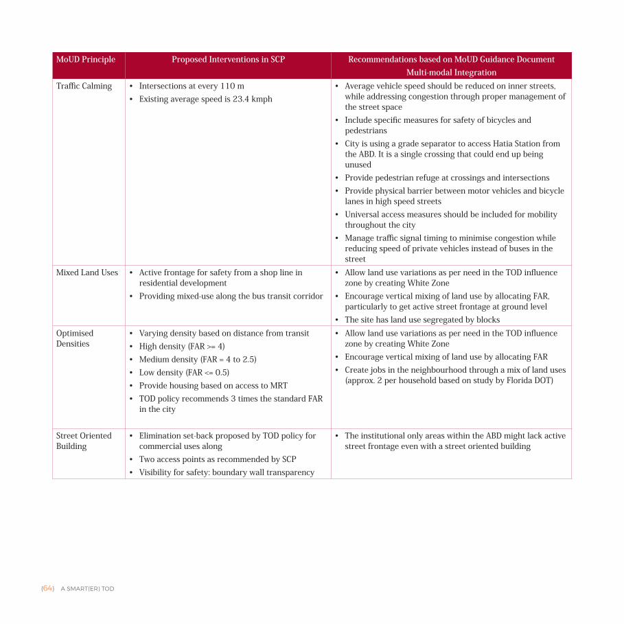
{64} A SMART(ER) TOD
MoUD Principle Proposed Interventions in SCP Recommendations based on MoUD Guidance Document Multi-modal Integration
Traffic Calming • Intersections at every 110 m • Existing average speed is 23.4 kmph
• Average vehicle speed should be reduced on inner streets, while addressing congestion through proper management of the street space
• Include specific measures for safety of bicycles and pedestrians
• City is using a grade separator to access Hatia Station from the ABD. It is a single crossing that could end up being unused
• Provide pedestrian refuge at crossings and intersections• Provide physical barrier between motor vehicles and bicycle
lanes in high speed streets• Universal access measures should be included for mobility
throughout the city• Manage traffic signal timing to minimise congestion while
reducing speed of private vehicles instead of buses in the street
Mixed Land Uses • Active frontage for safety from a shop line in residential development
• Providing mixed-use along the bus transit corridor
• Allow land use variations as per need in the TOD influence zone by creating White Zone
• Encourage vertical mixing of land use by allocating FAR, particularly to get active street frontage at ground level
• The site has land use segregated by blocksOptimised Densities
• Varying density based on distance from transit• High density (FAR >= 4)• Medium density (FAR = 4 to 2.5)• Low density (FAR <= 0.5)• Provide housing based on access to MRT• TOD policy recommends 3 times the standard FAR
in the city
• Allow land use variations as per need in the TOD influence zone by creating White Zone
• Encourage vertical mixing of land use by allocating FAR • Create jobs in the neighbourhood through a mix of land uses
(approx. 2 per household based on study by Florida DOT)
Street Oriented Building
• Elimination set-back proposed by TOD policy for commercial uses along
• Two access points as recommended by SCP• Visibility for safety: boundary wall transparency
• The institutional only areas within the ABD might lack active street frontage even with a street oriented building
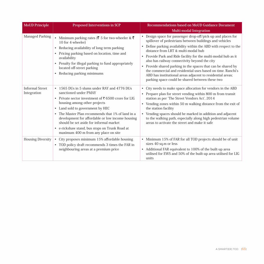
A SMART(ER) TOD {65}
MoUD Principle Proposed Interventions in SCP Recommendations based on MoUD Guidance Document Multi-modal Integration
Managed Parking • Minimum parking rates (` 5 for two-wheeler & ` 10 for 4-wheeler)
• Reducing availability of long term parking• Pricing parking based on location, time and
availability• Penalty for illegal parking to fund appropriately
located off-street parking• Reducing parking minimums
• Design space for passenger drop-off/pick-up and places for spillover of pedestrians between buildings and vehicles
• Define parking availability within the ABD with respect to the distance from LRT & multi-modal hub
• Provide Park and Ride facility for the multi-modal hub as it also has railway connectivity beyond the city
• Provide shared parking in the spaces that can be shared by the commercial and residential uses based on time. Ranchi’s ABD has institutional areas adjacent to residential areas; parking space could be shared between these two
Informal Street Integration
• 1565 DUs in 5 slums under RAY and 4776 DUs sanctioned under PMAY
• Private sector investment of ` 6500 crore for LIG housing among other projects
• Land sold to government by HEC• The Master Plan recommends that 1% of land in a
development for affordable or low income housing should be set aside for informal market
• e-rickshaw stand, bus stops on Trunk Road at maximum 400 m from any place on site
• City needs to make space allocation for vendors in the ABD• Prepare plan for street vending within 800 m from transit
station as per ‘The Street Vendors Act’, 2014• Vending zones within 50 m walking distance from the exit of
the station facility• Vending spaces should be marked in addition and adjacent
to the walking path, especially along high pedestrian volume areas to activate the street and make it safe
Housing Diversity • City proposes minimum 15% affordable housing• TOD policy draft recommends 3 times the FAR in
neighbouring areas at a premium price
• Minimum 15% of FAR for all TOD projects should be of unit sizes 40 sq.m or less
• Additional FAR equivalent to 100% of the built-up area utilised for EWS and 50% of the built-up area utilised for LIG units
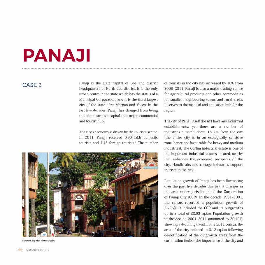
{66} A SMART(ER) TOD
PANAJIPanaji is the state capital of Goa and district headquarters of North Goa district. It is the only urban centre in the state which has the status of a Municipal Corporation, and it is the third largest city of the state after Margao and Vasco. In the last five decades, Panaji has changed from being the administrative capital to a major commercial and tourist hub.
The city’s economy is driven by the tourism sector. In 2011, Panaji received 6.90 lakh domestic tourists and 4.45 foreign tourists.4 The number
of tourists in the city has increased by 10% from 2008‒2011. Panaji is also a major trading centre for agricultural products and other commodities for smaller neighbouring towns and rural areas. It serves as the medical and education hub for the region.
The city of Panaji itself doesn't have any industrial establishments; yet there are a number of industries situated about 15 km from the city (the entire city is in an ecologically sensitive zone, hence not favourable for heavy and medium industries). The Corlim industrial estate is one of the important industrial estates located nearby that enhances the economic prospects of the city. Handicrafts and cottage industries support tourism in the city.
Population growth of Panaji has been fluctuating over the past five decades due to the changes in the area under jurisdiction of the Corporation of Panaji City (CCP). In the decade 1991‒2001, the census recorded a population growth of 36.26%. It included the CCP and its outgrowths up to a total of 22.63 sq.km. Population growth in the decade 2001‒2011 amounted to 20.19%, showing a declining trend. In the 2011 census, the area of the city reduced to 8.12 sq.km following de-notification of the outgrowth areas from the corporation limits.5 The importance of the city and Source: Daniel Hauptstein
CASE 2
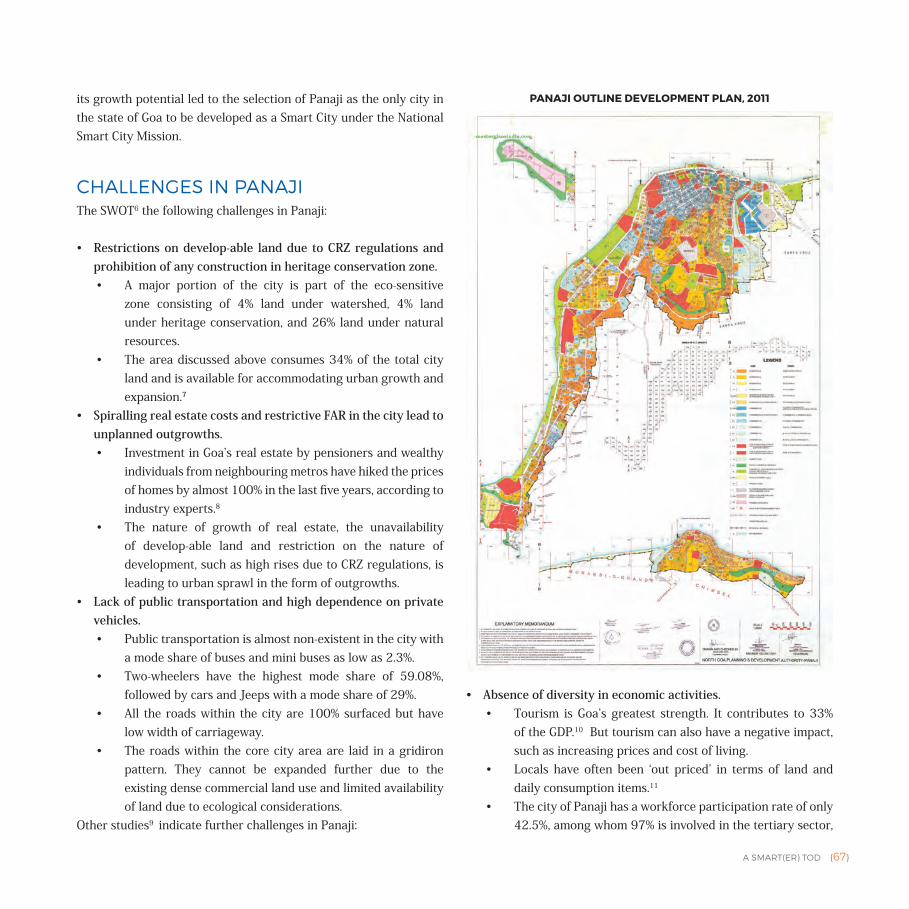
A SMART(ER) TOD {67}
its growth potential led to the selection of Panaji as the only city in the state of Goa to be developed as a Smart City under the National Smart City Mission.
CHALLENGES IN PANAJIThe SWOT6 the following challenges in Panaji:
• Restrictions on develop-able land due to CRZ regulations and prohibition of any construction in heritage conservation zone.• A major portion of the city is part of the eco-sensitive
zone consisting of 4% land under watershed, 4% land under heritage conservation, and 26% land under natural resources.
• The area discussed above consumes 34% of the total city land and is available for accommodating urban growth and expansion.7
• Spiralling real estate costs and restrictive FAR in the city lead to unplanned outgrowths.• Investment in Goa’s real estate by pensioners and wealthy
individuals from neighbouring metros have hiked the prices of homes by almost 100% in the last five years, according to industry experts.8
• The nature of growth of real estate, the unavailability of develop-able land and restriction on the nature of development, such as high rises due to CRZ regulations, is leading to urban sprawl in the form of outgrowths.
• Lack of public transportation and high dependence on private vehicles.• Public transportation is almost non-existent in the city with
a mode share of buses and mini buses as low as 2.3%. • Two-wheelers have the highest mode share of 59.08%,
followed by cars and Jeeps with a mode share of 29%. • All the roads within the city are 100% surfaced but have
low width of carriageway.• The roads within the core city area are laid in a gridiron
pattern. They cannot be expanded further due to the existing dense commercial land use and limited availability of land due to ecological considerations.
Other studies9 indicate further challenges in Panaji:
• Absence of diversity in economic activities. • Tourism is Goa’s greatest strength. It contributes to 33%
of the GDP.10 But tourism can also have a negative impact, such as increasing prices and cost of living.
• Locals have often been ‘out priced’ in terms of land and daily consumption items.11
• The city of Panaji has a workforce participation rate of only 42.5%, among whom 97% is involved in the tertiary sector,
PANAJI OUTLINE DEVELOPMENT PLAN, 2011
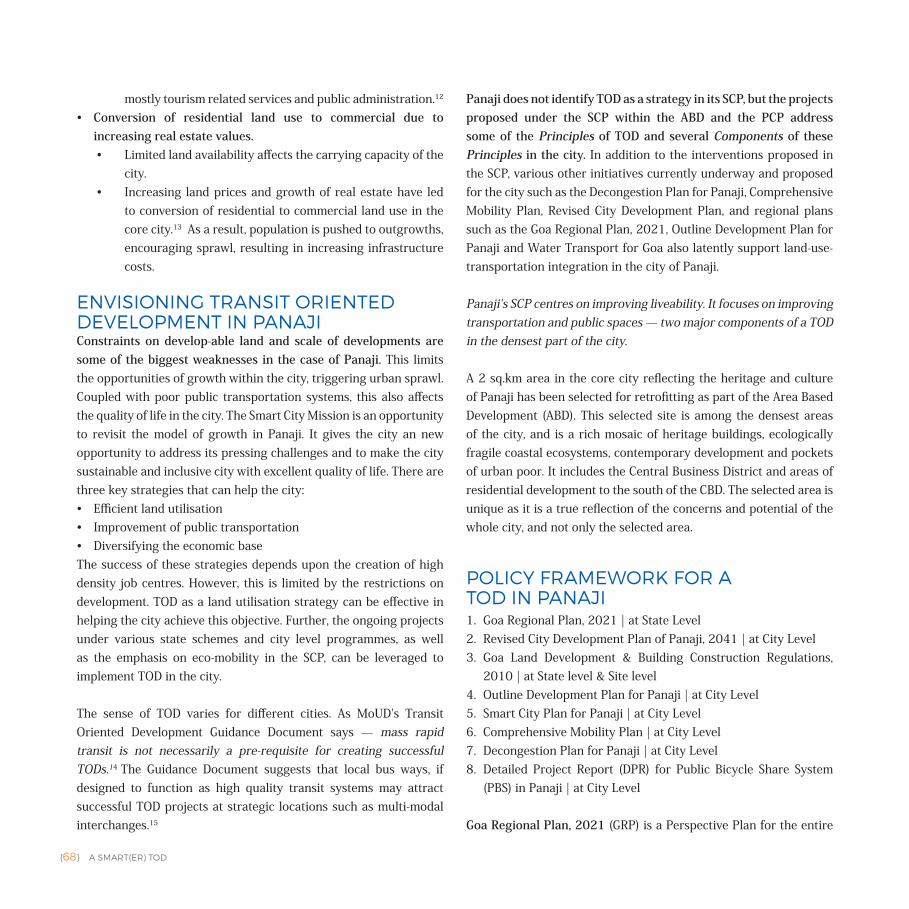
{68} A SMART(ER) TOD
mostly tourism related services and public administration.12 • Conversion of residential land use to commercial due to
increasing real estate values.• Limited land availability affects the carrying capacity of the
city. • Increasing land prices and growth of real estate have led
to conversion of residential to commercial land use in the core city.13 As a result, population is pushed to outgrowths, encouraging sprawl, resulting in increasing infrastructure costs.
ENVISIONING TRANSIT ORIENTED DEVELOPMENT IN PANAJIConstraints on develop-able land and scale of developments are some of the biggest weaknesses in the case of Panaji. This limits the opportunities of growth within the city, triggering urban sprawl. Coupled with poor public transportation systems, this also affects the quality of life in the city. The Smart City Mission is an opportunity to revisit the model of growth in Panaji. It gives the city an new opportunity to address its pressing challenges and to make the city sustainable and inclusive city with excellent quality of life. There are three key strategies that can help the city:• Efficient land utilisation • Improvement of public transportation• Diversifying the economic base The success of these strategies depends upon the creation of high density job centres. However, this is limited by the restrictions on development. TOD as a land utilisation strategy can be effective in helping the city achieve this objective. Further, the ongoing projects under various state schemes and city level programmes, as well as the emphasis on eco-mobility in the SCP, can be leveraged to implement TOD in the city.
The sense of TOD varies for different cities. As MoUD's Transit Oriented Development Guidance Document says — mass rapid transit is not necessarily a pre-requisite for creating successful TODs.14 The Guidance Document suggests that local bus ways, if designed to function as high quality transit systems may attract successful TOD projects at strategic locations such as multi-modal interchanges.15
Panaji does not identify TOD as a strategy in its SCP, but the projects proposed under the SCP within the ABD and the PCP address some of the Principles of TOD and several Components of these Principles in the city. In addition to the interventions proposed in the SCP, various other initiatives currently underway and proposed for the city such as the Decongestion Plan for Panaji, Comprehensive Mobility Plan, Revised City Development Plan, and regional plans such as the Goa Regional Plan, 2021, Outline Development Plan for Panaji and Water Transport for Goa also latently support land-use- transportation integration in the city of Panaji.
Panaji's SCP centres on improving liveability. It focuses on improving transportation and public spaces — two major components of a TOD in the densest part of the city.
A 2 sq.km area in the core city reflecting the heritage and culture of Panaji has been selected for retrofitting as part of the Area Based Development (ABD). This selected site is among the densest areas of the city, and is a rich mosaic of heritage buildings, ecologically fragile coastal ecosystems, contemporary development and pockets of urban poor. It includes the Central Business District and areas of residential development to the south of the CBD. The selected area is unique as it is a true reflection of the concerns and potential of the whole city, and not only the selected area.
POLICY FRAMEWORK FOR A TOD IN PANAJI1. Goa Regional Plan, 2021 | at State Level2. Revised City Development Plan of Panaji, 2041 | at City Level3. Goa Land Development & Building Construction Regulations,
2010 | at State level & Site level4. Outline Development Plan for Panaji | at City Level 5. Smart City Plan for Panaji | at City Level6. Comprehensive Mobility Plan | at City Level7. Decongestion Plan for Panaji | at City Level8. Detailed Project Report (DPR) for Public Bicycle Share System
(PBS) in Panaji | at City Level
Goa Regional Plan, 2021 (GRP) is a Perspective Plan for the entire
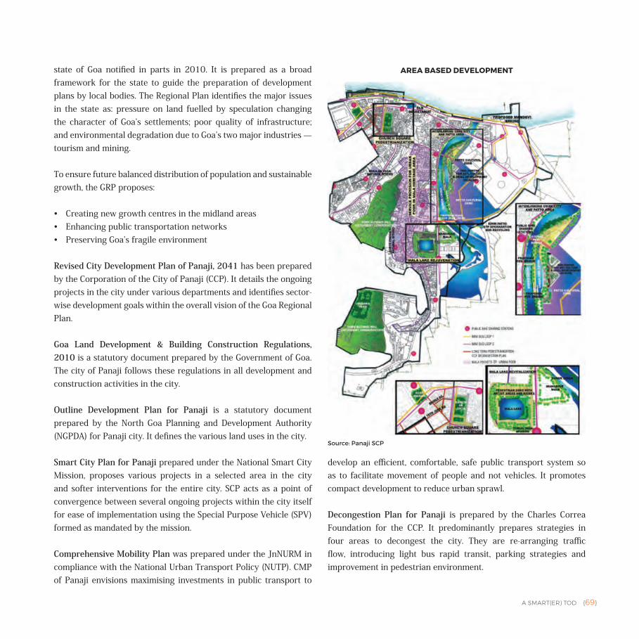
A SMART(ER) TOD {69}
state of Goa notified in parts in 2010. It is prepared as a broad framework for the state to guide the preparation of development plans by local bodies. The Regional Plan identifies the major issues in the state as: pressure on land fuelled by speculation changing the character of Goa’s settlements; poor quality of infrastructure; and environmental degradation due to Goa’s two major industries — tourism and mining.
To ensure future balanced distribution of population and sustainable growth, the GRP proposes:
• Creating new growth centres in the midland areas• Enhancing public transportation networks • Preserving Goa’s fragile environment
Revised City Development Plan of Panaji, 2041 has been prepared by the Corporation of the City of Panaji (CCP). It details the ongoing projects in the city under various departments and identifies sector-wise development goals within the overall vision of the Goa Regional Plan.
Goa Land Development & Building Construction Regulations, 2010 is a statutory document prepared by the Government of Goa. The city of Panaji follows these regulations in all development and construction activities in the city.
Outline Development Plan for Panaji is a statutory document prepared by the North Goa Planning and Development Authority (NGPDA) for Panaji city. It defines the various land uses in the city.
Smart City Plan for Panaji prepared under the National Smart City Mission, proposes various projects in a selected area in the city and softer interventions for the entire city. SCP acts as a point of convergence between several ongoing projects within the city itself for ease of implementation using the Special Purpose Vehicle (SPV) formed as mandated by the mission.
Comprehensive Mobility Plan was prepared under the JnNURM in compliance with the National Urban Transport Policy (NUTP). CMP of Panaji envisions maximising investments in public transport to
develop an efficient, comfortable, safe public transport system so as to facilitate movement of people and not vehicles. It promotes compact development to reduce urban sprawl.
Decongestion Plan for Panaji is prepared by the Charles Correa Foundation for the CCP. It predominantly prepares strategies in four areas to decongest the city. They are re-arranging traffic flow, introducing light bus rapid transit, parking strategies and improvement in pedestrian environment.
AREA BASED DEVELOPMENT
Source: Panaji SCP
{70} A SMART(ER) TOD
Detailed Project Report (DPR) for Public Bicycle Share (PBS) System in Panaji was developed by EMBARQ India for the CCP. It proposes PBS as a public transportation mode in the city with a dense network for bike stations and bike routes.
STRATEGIES FOR TODDENSITY
State Level | Goa Regional Plan (GRP)
• 80% of land of the state is under ecological conservation and regulated development.
• As per the GRP, the CBD in Panaji has the densest development in the state of Goa
• The GRP proposes new growth centres away from the existing urban centres including Panaji to ease the pressure on existing urban centres
City Level | Revised City Development Plan and Outline Development Plan
• The city has an average density of 4928 persons per sq.km (1232 households per sq.km).
• Population density has decreased by 32% in the decade 2001‒2011 due to outward migration.
• 34% of land in the city is protected or reserved for natural resources, conservation/preservation, defence land and watershed.
• The city has a compact, low-rise built form throughout except in the Patto administrative area where it is high rise.
• Unavailability of land and restriction on FAR has caused increase in land prices in the city, making it unaffordable for everyone except the very high income group. This is leading to mushrooming of outgrowths just outside the city level.
• ODP defines land uses in the city, and adopts the GLDBCR for development regulations in each land use.
Site Level | Smart City Plan and Goa Land Development & Building Construction Regulations, 2010• The site selected for the ABD has a density of 6602 persons per
sq.km, which is higher than the rest of the city. The site, which is 25% of the total city area, accommodates 33% of the total city population.
• FAR within the selected site is based on the land uses defined by the Outline Development Plan. The maximum FAR is in Patto area, which amounts to 2.5. The core city comprises mostly of buildings listed for heritage conservation. Here, commercial buildings are limited to an FAR of 2 and the residential zone has a maximum FAR of 1.
• A large portion of the ABD falls within the conservation area. In such areas, development is restricted by: maximum ground coverage of 70% and maximum permissible FAR of 2 for commercial use on plots smaller than 300 sq.m.
DIVERSITY
State Level | Goa Regional Plan
• Tourism contributes approximately 34% of the State Domestic Product, providing employment to nearly 30% of the total workforce in the state.
City Level | Revised City Development Plan and Outline Development Plan
• The Revised CDP assumes that mixed-use in the city will increase by 2% over the next three decades. Using this assumption, it is estimated that the requirement of mixed-use houses by 2041 will be 0.34 lakh.
• The ODP includes Panaji city (8.12 sq.km) and adjacent areas (0.18 sq.km). Only 66% (5.50 sq.km) of the land is developable as per ODP. The break-up of existing land use (developable land) is shown.
• Except for the old city area of Panaji, there is a segregation of land uses with only residential uses in the southern part of the
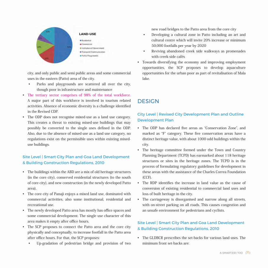
A SMART(ER) TOD {71}
city, and only public and semi public areas and some commercial uses in the eastern (Patto) area of the city. • Parks and playgrounds are scattered all over the city,
though poor in infrastructure and maintenance • The tertiary sector comprises of 98% of the total workforce.
A major part of this workforce is involved in tourism related activities. Absence of economic diversity is a challenge identified in the Revised CDP.
• The ODP does not recognise mixed-use as a land use category. This creates a threat to existing mixed-use buildings that may possibly be converted to the single uses defined in the ODP. Also, due to the absence of mixed-use as a land use category, no regulations exist on the permissible uses within existing mixed-use buildings.
Site Level | Smart City Plan and Goa Land Development & Building Construction Regulations, 2010
• The buildings within the ABD are a mix of old heritage structures (in the core city), conserved residential structures (to the south of core city), and new construction (in the newly developed Patto area).
• The core city of Panaji enjoys a mixed land use, dominated with commercial activities, also some institutional, residential and recreational use.
• The newly developed Patto area has mostly has office spaces and some commercial development. The single use character of this area makes it empty after office hours.
• The SCP proposes to connect the Patto area and the core city physically and conceptually, to increase footfall in the Patto area after office hours. For that, the SCP proposes: • Up-gradation of pedestrian bridge and provision of two
new road bridges to the Patto area from the core city• Developing a cultural zone in Patto including an art and
cultural centre which will invite 20% increase or minimum 50,000 footfalls per year by 2020
• Reviving abandoned creek side walkways as promenades with creek-side cafés
• Towards diversifying the economy and improving employment opportunities, the SCP proposes to develop aquaculture opportunities for the urban poor as part of revitalisation of Mala lake.
DESIGN
City Level | Revised City Development Plan and Outline Development Plan
• The ODP has declared five areas as “Conservation Zone”, and marked as “F” category. These five conservation areas have a distinct heritage value, with about 1000 odd buildings within the city.
• The heritage committee formed under the Town and Country Planning Department (TCPD) has earmarked about 118 heritage structures or sites in the heritage zones. The TCPD is in the process of formulating regulatory guidelines for development in these areas with the assistance of the Charles Correa Foundation (CCF).
• The RDP identifies the increase in land value as the cause of conversion of existing residential to commercial land uses and loss of built heritage in the city.
• The carriageway is disorganised and narrow along all streets, with on-street parking on all roads. This causes congestion and an unsafe environment for pedestrians and cyclists.
Site Level | Smart City Plan and Goa Land Development & Building Construction Regulations, 2010
• The GLDBCR prescribes the set-backs for various land uses. The minimum front set-backs are:
LAND-USE
{72} A SMART(ER) TOD
• Commercial zones in core city and Patto (zone C1 and zone CS respectively) = 10 m
• Commercial zone in rest of the city (zone C2‒C4) = 5 m• All public = 5m• All residential (S1- S4/R1- R4) = 3 m
• The SCP proposes several projects to preserve and improve the urban design of the site:• Table-top junction with street furniture at pedestrianised
important tourist spots and landmarks • Street cafés on pedestrianised roads and creek sides• Conservation and preservation of biodiversity to improve
natural and open spaces in the city • Relaying of all roads in ABD to introduce pedestrian and
NMT facilities• Avenue plantation• Heritage conservation plan and constitution of heritage
cell, together with FSI incentives for preserving heritage buildings
• Improvement of stepped pedestrian pathways in high slopes areas
MOBILITY
State Level | Goa Regional Plan
• The state of Goa has 20 ferry routes, out of which three are connected to Panaji.
• The GRP projects that by 2021, 20 lakh people could generate 30 lakh ferry trips per day (at 1.5 trips per person per day) in the state.
• The Kadamba Transport Corporation is the state body responsible for public transportation in the state.
• Goa ranks first among all the states in terms of households owning two-wheelers and/or a car with around 81.5% compared to the national average of 25.7%.
City Level | Revised City Development Plan (RCDP), Outline Development Plan, Decongestion Plan and DPR for PBS System
• Roads are developed by the State Public Works Department (PWD) and maintained by the CCP.
• The total road length in the city is 77 km.• The existing road network is dense with small block sizes.• The city has 100% coverage of bitumen tar (BT) surface roads.• As per the development plan, 12% of land should be covered by
roads. However, the total road coverage in the city is only 3.6% of the total city area (5.45% of ODP area).
• As per the gap analysis, the RCDP suggests that the city requires 26.28 km of additional road network by the end of 2021.
• The width of road ranges from 3 m to 14 m in the city. • 77% of roads have 4 lane carriage widths (8 to 14m)• 12% of roads has two lane carriage widths (4 to 7 m) • 11% have single lane (< 3 m)
• The city road network has very little scope for expansion due to dense commercial development and the presence of protected structures in the most congested stretches of road. Water transport is being leveraged for inter-city transportation.
• On an average, a total 1,06,014 vehicles enter in the city on a daily basis through the two bridges, which are the only access points, creating a bottleneck.
• All the major roads have on-street parking, which reduces the effective RoW. Parking is not regularised and free off charge.
• The public bus transport system in the Panaji CCP is currently being served by private operators and Kadamba Transport Corporation Limited (KTC).
• The fleet of buses operated by the private sector includes 70 buses operating in the Panaji CCP area. Two buses are operated by the KTC.
• The Road Transport Authority of Goa decides routes for the public transport network and registers private buses which can ply on these roads.
• Currently, public transit is only 2.3% of mode share.• The overall bus transport network favours only key tourist routes
and does not prioritise the local residents and daily commuters. • Since the ticketing system favours the operator, the drivers wait
for the bus to get overcrowded before they start the trip.
A SMART(ER) TOD {73}
• The decongestion model for Panaji was prepared by the Charles Correa Foundation. It proposes several initiatives to improve the mobility scenario in the city, addressing three main issues: • Public Transportation — a hop-on-hop-off bus system on
dedicated lanes in the core city extending to residential areas in the south
• Parking management — designated on-street parking and on-site parking areas
• Pedestrian environment — streets for pedestrianisation, supported by the public transportation and parking strategies
• The Corporation of the City of Panaji (CCP) and EMBARQ India prepared the DPR for a city level public bike share system in Panaji. The system proposes:• 1040 bicycles• 66 bike stations and 1560 docks• At least one station at every 250 m• Higher density of stations and number of bikes in core
commercial areas• Bicycle parking in existing on-street car parking spaces
• Considering the narrow carriageway in the city, PBS is proposed in the city.• The targets users of the system are residents, who travel
distances less than 5 km, and tourists• Presently, mode share of cycling is dismally low at 1%• Over 4% of trips are made in taxis and two-wheelers on hire• The bike share system is meant to reduce this mode share
of taxis and two-wheelers on hire
Site Level | Smart City Plan, Decongestion Plan and DPR for PBS System
• The major bus terminal in the North Goa district is situated within the site selected for ABD.
• The SCP proposes and converges several projects towards improvement of public transportation and pedestrian environment.• Light Bus Rapid Transit System (LBRT) with 20 mini buses• Bus terminus redesigning at Patto• Improvement in ferry system at Panaji
• Citywide public bike share system is proposed in the SCP. In the site for ABD there will be:
• 440 cycles • 15 docking stations at maximum 250 m spacing • Pedestrianisation on high pedestrian footfall streets and
squares• The SCP identifies roads that need to be relayed with segregation
of automobiles, bicycles, pedestrians and parking areas.• The SCP proposes to improve connectivity between the core city
and Patto area by constructing new pedestrian and vehicular bridges.
• The SCP targets: • 7000 trips/day to be shifted to 20 mini buses • At least 10% mode share shift to NMT
HOUSING
State Level | Goa Regional Plan
• The Goa Housing Board is the only organisation that addresses the needs of the EWS and middle income categories even though a lot of construction is being done by private developers, individuals, private limited companies and cooperative housing societies.
• The board has concentrated on the construction of LIG and MIG tenements in the new colonies set up in Porvorim, Margao, Ponda, Bicholim and Mapusa. The Housing Board has not implemented any projects within the Panaji city limits.
• To cope with the rising population and to meet future residential requirements the Housing Board has identified a few pockets of land within a range of 12 to 15 km from Panaji city for comprehensive housing development programmes.
• In case of EWS developments (for sub-division and for building construction) the competent authority is allowed to relax regulations to the extent that:• Minimum size of the plot is relaxed to 60 sq.m • Maximum coverage may be relaxed up to 60%• Minimum size of rooms is relaxed to 2 sq.m
{74} A SMART(ER) TOD
City Level | Revised City Development Plan, Rapid Baseline Assessment of Panaji City and Report of Household and Socio-Economic Survey under Rajiv Awas Yojana (RAY)• The total number of households in ODP region is 17,807 out of
which 10,158 are located within the CCP area as per the 2011 census.
• The household size in Panaji has reduced from 4.73 in 1991 to only 4 in 2011.
• The city is characterised by medium-rise, high density housing in the core city and low-rise, moderately dense housing in the peripheral areas. The last decade has witnessed development of multi-rise residential and commercial structures. Organised layouts are developing towards the peripheral areas of the city.
• Panaji has shown a real estate growth with a hike of home prices by 100% between 2010‒2015.• The prices of properties have increased to double in the
last five years with approximately ` 35,000 per sq.m to ` 70,000 per sq.m on an average
• Census 2011 identifies Panaji as a slum free city. However, a survey has been carried out with the help of Municipal Elected Representatives/Corporations, which identified 2517 households under the slum category which is classified as “slums like area”. Out of these, the following is the land tenure status of some households: • 779 have encroached private land• 573 live in rented properties• 179 have encroached public land
Site Level | Smart City Plan and Goa Land Development & Building Construction Regulations, 2010
• The SCP recognises the existence of urban poor settlements in the ecologically sensitive area. Infrastructure improvement is proposed in such areas.
• The ABD has residential areas under conservation land use as per the Outline Development Plan (ODP). To motivate and engage private owners and developers it is proposed to provide:• FSI incentives for developers to conserve heritage buildings
• TDR to building owners, which will provide equivalent built space in other areas, in case of unused FSI on heritage structures
• Maximum permissible FSI for residential structures is 1 and maximum permissible height is 15 m.
DELIVERY MECHANISMSCurrently the majority of urban services do not fall under the CCP. Only the issuing of building construction licenses is handled by the CCP. Due to the lack of capacity and unavailability of technical as well as managerial staff, functions with respect to planning and implementation of services such as water supply, sewage collection, construction of roads and bridges, are dealt by the state Public Works Department (PWD), the planning and implementation of storm water drainage related works are dealt by the state Water Resources Department (WRD), and the urban planning functions of the urban local body are undertaken by the North Goa Planning and Development Authority.
Imagine Panaji Smart City Development Limited (IPSCDL) — the SPV in Panaji under the National Smart City Mission includes representatives from:
• Ministry of Urban Development, GoI• Department of Urban Development, GoG• Department of Finance, GoG• Corporation of City of Panaji (CCP)• Industry Association• Indian Institute of Architects/Planners/Engineers• Public Works Department, GoG• Goa State Infrastructure Development Corporation Ltd. (GSIDCL)
Stakeholders for implementing SCP in Panaji are:
• Water Resources Department of Goa
A SMART(ER) TOD {75}
• Public Works Department of Goa• Department of Town and Country Planning of Goa• Goa State Urban Development Agency• Department of Art and Culture of Goa• National Bank for Agriculture and Rural Development (NABARD)• Kadamba Transport Corporation (KTC)• Economic Development Corporation Ltd (EDC)• Department of Information Technology, GoG• Goa State Pollution Control Board• Directorate of Transport, Goa• District Magistrate, North Goa• Captain of Ports, Government of Goa• Margao Port Trust• River Navigation Department, GoG• Electricity Department, GoG• Travel and Tourism Association of Goa• Food and Drug Administration Department• Forest Department of Goa• Mangrove Society of India• Botanical Society of Goa• Birds Institute of Goa• Peoples Biodiversity Register• Petroleum and Natural Gas Regulatory Board• State Biodiversity Board of Goa• Charles Correa Foundation• Waste Wise Foundation• Private agencies
• Drishti Marine Solutions Pvt. Ltd• Chartered Speed Pvt. Ltd• ParXsys mobit systems• LKS (Ingenieria) India Pvt. Ltd.• Essel Infra Projects Ltd.• Radioactiv Entertainment
• Local Governments for Sustainability — South Asia (ICLEI)• The Energy and Resources Institute (TERI)• Goa Heritage Action Group (GHAG)
Financial resources for implementing SCP in Panaji are:
• Smart City Mission Fund from Central and State Government• National Smart Grid Mission Fund• State Water Resources Department Fund• Public Works Department funding from State Government• Town and Country Planning Department of State Funding• Integrated Power Distribution Scheme funds• Atal Mission For Rejuvenation and Urban Transformation
(AMRUT) • Goa State Urban Development Agency funding• National Solar City Mission• DFID funding under challenge fund scheme by Ministry of
Housing and Urban Poverty Alleviation• Public Private Partnership• Corporate Service Responsibility (CSR) funds• State Department of Art and Culture funding• National Bank for Agriculture and Rural Development (NABARD)
funds
CITY'S APPROACH IN SMART CITY PLANGoals in the SCP of Panaji are derived from the broader city goals as per the Revised City Development Plan for Panaji 2041.16 These goals align with the principles of TOD:
1. Promote mixed-use• Patto area, with its contemporary administrative and commercial
development, is largely deserted after office hours. This area is isolated from the core city, which is accessed by a bridge. The SCP strategically proposes to bridge these two islands physically and conceptually. Projects such as Art and cultural centre are proposed under the SCP. They will increase open spaces in the core city and footfall in the Patto area.
• As the SCP does not propose any housing in the city, there is an opportuinty to introduce it in the Patto area since it will increase
{76} A SMART(ER) TOD
the housing stock in the city and improve ridership in public transportation originating at Kadamba bus station and also increase footfall in Patto area after evening hours.
• Mixed-use should be defined as a land use category in Panaji to preserve the built form and activities of the city.
2. Leverage strength of rich heritage• City is encouraging conservation of heritage structures and their
façades, along with the pedestrianisation of the core city area in order to enhance experience of the visitors within the ABD.
3. Improve public transportation• Eco-mobility is the central theme of Panaji's SCP. Derived from
previous initiatives in the city such as the Decongestion Plan and Comprehensive Mobility Plan, the SCP lays emphasis on improvement of public transportation and NMT in the city and especially in the ABD.
• In addition to the projects proposed and converged in the SCP, the city has to prepare a parking policy to manage the disorganised parking in the city. This should include parking restraints and dynamic parking pricing.
• It is recommended that a park-and-ride garage be constructed at the bus station to reduce congestion along with the creation of pedestrian and bicycle friendly streets. This will encourage commuters to park their cars and ride the public bus loops from the terminus.
• Presently auto rickshaws have little mode share — only 0.18% — but the expected modal shift from private to public transportation will be accompanied by a higher demand for intermediate para transport (IPT) such as auto rickshaws. An organised parking and management of IPT at crucial public transportation stations such as bus stops, ferry stations and terminus is necessary.
4. Diversification of economy• The SCP has identified projects to diversify economy and
create more job opportunities. Rejuvenation of Mala Lake envisages reviving the lake as a tourist attraction whilst creating employment opportunities related to tourism and aquaculture for the locals.
• Additionally the city needs create an environment to prevent outmigration.
• The existing FSI, building height and set-backs in the Patto area allow for only conservative development. Options to intensify the development need to be explored so that more jobs can be created that are not tourism related.
• To curb the increasing cost of living and provide opportunities for the urban poor, it is recommended that street vending zones be introduced in the bus terminus and along pedestrianised streets.
Recommendation: Developing Patto area as a CBD on TOD Principles
In the ABD site selected in the SCP, except for the Patto area to the west of the site, all other areas have limited scope of land development due to building regulations and fragmented land ownership. The EDC Ltd developed the Patto area, a vast land area of about 1,77,000 sq.m by reclamation. A mixed-use development in this area will make it active during all times of the day with different land uses peaking at different times of the day.
Pushkarev and Zupan in 1977 prescribed minimum residential densities ranging between 5400 persons per sq.km17 to 9000 persons per sq.km depending on the mode of transit. The highest gross density in Panaji is in its ABD site and amounts to 6602 persons per sq.km. There is an opportunity to adopt TOD as a strategy for development in Panaji. Listed below are the strengths and opportunities in Patto to be developed as a new CBD on TOD Principles
Strengths• The Outline Development Plan (ODP) of Panaji provides detailed
zoning throughout the city. Developed in line with the Goa Land Development and Building Construction Regulations, 2010, the ODP offers potential to manage ground coverage, FSI and building heights in areas that are not protected in the city.
• The maximum permissible FSI and building heights as per these regulations is still very conservative, but the presence of a
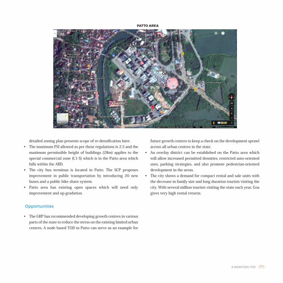
A SMART(ER) TOD {77}
detailed zoning plan presents scope of re-densification later. • The maximum FSI allowed as per these regulations is 2.5 and the
maximum permissible height of buildings (28m) applies to the special commercial zone (C1-S) which is in the Patto area which falls within the ABD.
• The city bus terminus is located in Patto. The SCP proposes improvement in public transportation by introducing 20 new buses and a public bike share system.
• Patto area has existing open spaces which will need only improvement and up-gradation.
Opportunities
• The GRP has recommended developing growth centres in various parts of the state to reduce the stress on the existing limited urban centres. A node based TOD in Patto can serve as an example for
future growth centres to keep a check on the development sprawl across all urban centres in the state.
• An overlay district can be established on the Patto area which will allow increased permitted densities, restricted auto-oriented uses, parking strategies, and also promote pedestrian-oriented development in the areas.
• The city shows a demand for compact rental and sale units with the decrease in family size and long duration tourists visiting the city. With several million tourists visiting the state each year, Goa gives very high rental returns.
PATTO AREA
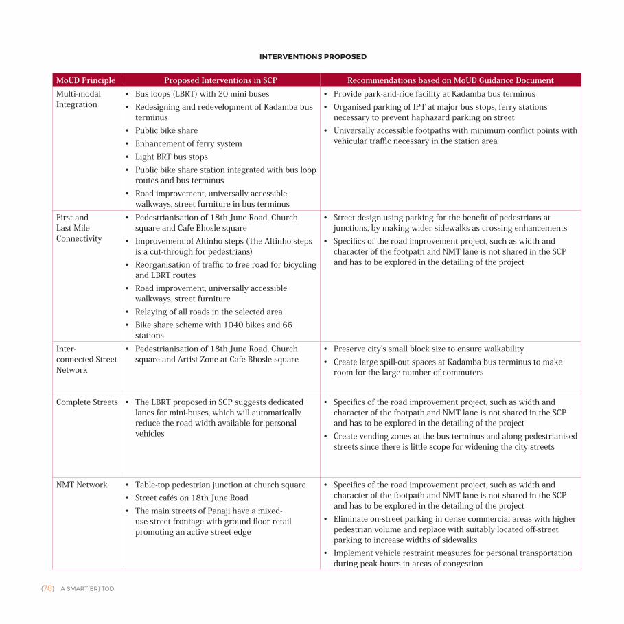
{78} A SMART(ER) TOD
MoUD Principle Proposed Interventions in SCP Recommendations based on MoUD Guidance Document Multi-modal Integration
• Bus loops (LBRT) with 20 mini buses• Redesigning and redevelopment of Kadamba bus
terminus• Public bike share • Enhancement of ferry system• Light BRT bus stops• Public bike share station integrated with bus loop
routes and bus terminus• Road improvement, universally accessible
walkways, street furniture in bus terminus
• Provide park-and-ride facility at Kadamba bus terminus • Organised parking of IPT at major bus stops, ferry stations
necessary to prevent haphazard parking on street • Universally accessible footpaths with minimum conflict points with
vehicular traffic necessary in the station area
First and Last Mile Connectivity
• Pedestrianisation of 18th June Road, Church square and Cafe Bhosle square
• Improvement of Altinho steps (The Altinho steps is a cut-through for pedestrians)
• Reorganisation of traffic to free road for bicycling and LBRT routes
• Road improvement, universally accessible walkways, street furniture
• Relaying of all roads in the selected area• Bike share scheme with 1040 bikes and 66
stations
• Street design using parking for the benefit of pedestrians at junctions, by making wider sidewalks as crossing enhancements
• Specifics of the road improvement project, such as width and character of the footpath and NMT lane is not shared in the SCP and has to be explored in the detailing of the project
Inter- connected Street Network
• Pedestrianisation of 18th June Road, Church square and Artist Zone at Cafe Bhosle square
• Preserve city's small block size to ensure walkability• Create large spill-out spaces at Kadamba bus terminus to make
room for the large number of commuters
Complete Streets • The LBRT proposed in SCP suggests dedicated lanes for mini-buses, which will automatically reduce the road width available for personal vehicles
• Specifics of the road improvement project, such as width and character of the footpath and NMT lane is not shared in the SCP and has to be explored in the detailing of the project
• Create vending zones at the bus terminus and along pedestrianised streets since there is little scope for widening the city streets
NMT Network • Table-top pedestrian junction at church square• Street cafés on 18th June Road• The main streets of Panaji have a mixed-
use street frontage with ground floor retail promoting an active street edge
• Specifics of the road improvement project, such as width and character of the footpath and NMT lane is not shared in the SCP and has to be explored in the detailing of the project
• Eliminate on-street parking in dense commercial areas with higher pedestrian volume and replace with suitably located off-street parking to increase widths of sidewalks
• Implement vehicle restraint measures for personal transportation during peak hours in areas of congestion
INTERVENTIONS PROPOSED
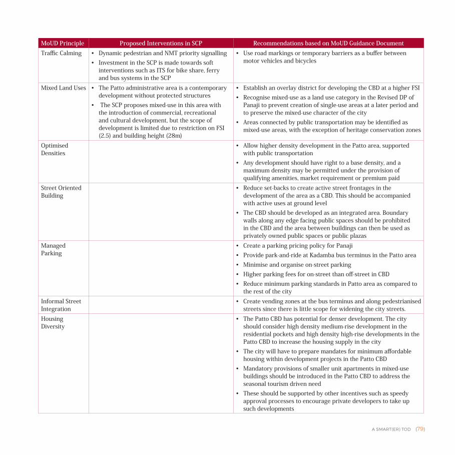
A SMART(ER) TOD {79}
MoUD Principle Proposed Interventions in SCP Recommendations based on MoUD Guidance Document Traffic Calming • Dynamic pedestrian and NMT priority signalling
• Investment in the SCP is made towards soft interventions such as ITS for bike share, ferry and bus systems in the SCP
• Use road markings or temporary barriers as a buffer between motor vehicles and bicycles
Mixed Land Uses • The Patto administrative area is a contemporary development without protected structures
• The SCP proposes mixed-use in this area with the introduction of commercial, recreational and cultural development, but the scope of development is limited due to restriction on FSI (2.5) and building height (28m)
• Establish an overlay district for developing the CBD at a higher FSI• Recognise mixed-use as a land use category in the Revised DP of
Panaji to prevent creation of single-use areas at a later period and to preserve the mixed-use character of the city
• Areas connected by public transportation may be identified as mixed-use areas, with the exception of heritage conservation zones
Optimised Densities
• Allow higher density development in the Patto area, supported with public transportation
• Any development should have right to a base density, and a maximum density may be permitted under the provision of qualifying amenities, market requirement or premium paid
Street Oriented Building
• Reduce set-backs to create active street frontages in the development of the area as a CBD. This should be accompanied with active uses at ground level
• The CBD should be developed as an integrated area. Boundary walls along any edge facing public spaces should be prohibited in the CBD and the area between buildings can then be used as privately owned public spaces or public plazas
Managed Parking
• Create a parking pricing policy for Panaji• Provide park-and-ride at Kadamba bus terminus in the Patto area • Minimise and organise on-street parking• Higher parking fees for on-street than off-street in CBD• Reduce minimum parking standards in Patto area as compared to
the rest of the cityInformal Street Integration
• Create vending zones at the bus terminus and along pedestrianised streets since there is little scope for widening the city streets.
Housing Diversity
• The Patto CBD has potential for denser development. The city should consider high density medium-rise development in the residential pockets and high density high-rise developments in the Patto CBD to increase the housing supply in the city
• The city will have to prepare mandates for minimum affordable housing within development projects in the Patto CBD
• Mandatory provisions of smaller unit apartments in mixed-use buildings should be introduced in the Patto CBD to address the seasonal tourism driven need
• These should be supported by other incentives such as speedy approval processes to encourage private developers to take up such developments
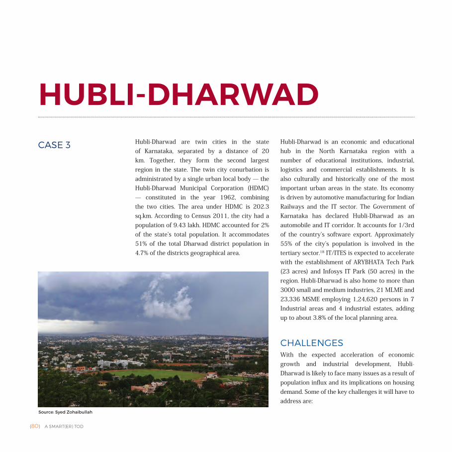
{80} A SMART(ER) TOD
HUBLI-DHARWADHubli-Dharwad are twin cities in the state of Karnataka, separated by a distance of 20 km. Together, they form the second largest region in the state. The twin city conurbation is administrated by a single urban local body — the Hubli-Dharwad Municipal Corporation (HDMC) — constituted in the year 1962, combining the two cities. The area under HDMC is 202.3 sq.km. According to Census 2011, the city had a population of 9.43 lakh. HDMC accounted for 2% of the state’s total population. It accommodates 51% of the total Dharwad district population in 4.7% of the districts geographical area.
Hubli-Dharwad is an economic and educational hub in the North Karnataka region with a number of educational institutions, industrial, logistics and commercial establishments. It is also culturally and historically one of the most important urban areas in the state. Its economy is driven by automotive manufacturing for Indian Railways and the IT sector. The Government of Karnataka has declared Hubli-Dharwad as an automobile and IT corridor. It accounts for 1/3rd of the country’s software export. Approximately 55% of the city’s population is involved in the tertiary sector.18 IT/ITES is expected to accelerate with the establishment of ARYBHATA Tech Park (23 acres) and Infosys IT Park (50 acres) in the region. Hubli-Dharwad is also home to more than 3000 small and medium industries, 21 MLME and 23,336 MSME employing 1,24,620 persons in 7 Industrial areas and 4 industrial estates, adding up to about 3.8% of the local planning area.
CHALLENGES With the expected acceleration of economic growth and industrial development, Hubli-Dharwad is likely to face many issues as a result of population influx and its implications on housing demand. Some of the key challenges it will have to address are:
Source: Syed Zohaibullah
CASE 3
A SMART(ER) TOD {81}
• Providing infrastructure to support a huge floating population — according to the CDP, this number is currently more than 4 lakh.
• Integration of the prospective development along the upcoming BRT corridors with the existing non-contiguous development in between Hubli-Dharwad and the rest of the city. The segregated development has resulted in poor infrastructure facilities within these developments.
• Managing the significant unplanned commercial activities and traffic on the streets in the core city.
• With the upcoming IT sector and investment in industrial infrastructure, the opportunities for business and commercial activities are expected to grow further in Hubli-Dharwad necessitating the: • Provision of additional infrastructure to support the
expected rise in number of jobs and businesses• Management of the increasing housing demand due to the
increased employment opportunities in the city• Ensuring high quality of public transit and improving its
contribution to the mode share. The city will need to manage the increasing private vehicle ownership.
PLANNING FOR A SUCCESSFUL TOD IN HUBLI-DHARWADHubli-Dharwad’s strategy is to develop its growth corridor on TOD principles. The existing support mechanisms for implementing TOD exists at the following levels:
• Regional level: The State Transport Corporation buses serve as the public transit for the city of Hubli. The North Western Karnataka Road Transport Corporation (NWKRTC) jurisdiction covers the Belagavi, Dharwad, North Canara, Bagalkot, Gadag and Haveri districts.
• City level: A Comprehensive Development Plan (CDP) along with the zoning regulations guides the city’s spatial growth.
• Site level: Smart City Plan of Hubli-Dharwad has identified the area around the second phase of the BRT corridor to be developed using TOD Principles.
• Building level: Building Bye-laws regulate the building level development based on uses.
Hubli-Dharwad's Vision
The city’s vision, as stated in the City Development Strategy, focuses on providing a high quality living environment to its citizens through preserving its economic, historical, cultural and natural environment. It aims to establish Hubli-Dharwad's identity as: A historical, cultural city and a regional hub of diverse economic activities — agro based, trade and industry, IT enabled services, retail trade, tourism, finances, education and health —that provides a high standard of living and high quality of civic services to all its citizens and preserves its natural ecology and environment.
Hubli-Dharwad’s SCP vision takes this forward by aiming at becoming a regional business and commerce hub with the support of existing economic diversity to provide a better and inclusive environment to its population. According to the document, Hubli-Dharwad aspires to be the gateway for the southern Deccan region in terms of trade, business and commerce. It intends to achieve this with the spirit of inclusion and citizen empowerment, by synergising the locational advantage, technology, infrastructure, manpower resources and smart governance. This will also make the city high on liveability and sustainability, preserving its rich cultural heritage.
Hubli-Dharwad has been trying to address some of its key issues of non-contiguous spatial development and overcrowded CBD areas by using TOD principles of building denser) — mixed-use developments along the public transit corridors. Navanagar has been identified as pilot project along the proposed Phase I of the BRT in the CDP. SCP aims to establish TOD along Phase II of the BRT to support the proposed city-scale commercial development.
Policy FrameworkFor Hubli-Dharwad, the policy framework19 is primarily comprised of:
1. Hubli-Dharwad Comprehensive Development Plan, 2021 | at City Level
2. Hubli-Dharwad Smart City Plan | at City Level and Site Level3. Hubli-Dharwad Mahanagar Palike Building Bye-laws, 2004 | at
City level
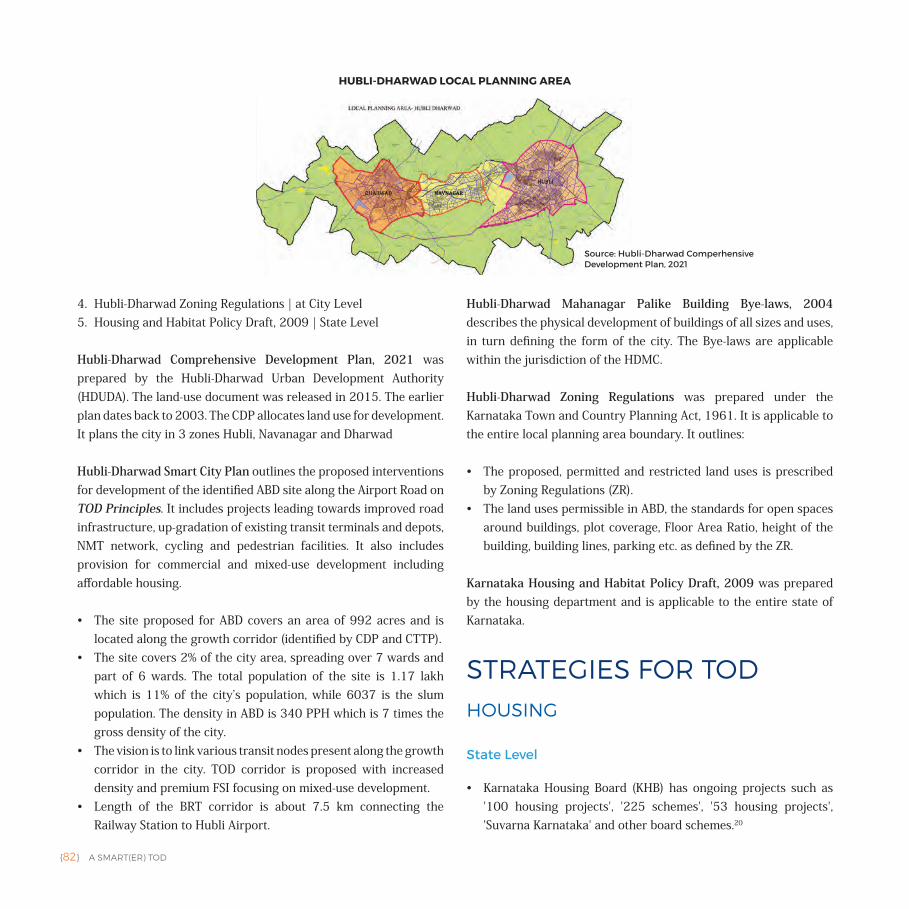
{82} A SMART(ER) TOD
4. Hubli-Dharwad Zoning Regulations | at City Level5. Housing and Habitat Policy Draft, 2009 | State Level
Hubli-Dharwad Comprehensive Development Plan, 2021 was prepared by the Hubli-Dharwad Urban Development Authority (HDUDA). The land-use document was released in 2015. The earlier plan dates back to 2003. The CDP allocates land use for development. It plans the city in 3 zones Hubli, Navanagar and Dharwad
Hubli-Dharwad Smart City Plan outlines the proposed interventions for development of the identified ABD site along the Airport Road on TOD Principles. It includes projects leading towards improved road infrastructure, up-gradation of existing transit terminals and depots, NMT network, cycling and pedestrian facilities. It also includes provision for commercial and mixed-use development including affordable housing.
• The site proposed for ABD covers an area of 992 acres and is located along the growth corridor (identified by CDP and CTTP).
• The site covers 2% of the city area, spreading over 7 wards and part of 6 wards. The total population of the site is 1.17 lakh which is 11% of the city’s population, while 6037 is the slum population. The density in ABD is 340 PPH which is 7 times the gross density of the city.
• The vision is to link various transit nodes present along the growth corridor in the city. TOD corridor is proposed with increased density and premium FSI focusing on mixed-use development.
• Length of the BRT corridor is about 7.5 km connecting the Railway Station to Hubli Airport.
Hubli-Dharwad Mahanagar Palike Building Bye-laws, 2004 describes the physical development of buildings of all sizes and uses, in turn defining the form of the city. The Bye-laws are applicable within the jurisdiction of the HDMC.
Hubli-Dharwad Zoning Regulations was prepared under the Karnataka Town and Country Planning Act, 1961. It is applicable to the entire local planning area boundary. It outlines:
• The proposed, permitted and restricted land uses is prescribed by Zoning Regulations (ZR).
• The land uses permissible in ABD, the standards for open spaces around buildings, plot coverage, Floor Area Ratio, height of the building, building lines, parking etc. as defined by the ZR.
Karnataka Housing and Habitat Policy Draft, 2009 was prepared by the housing department and is applicable to the entire state of Karnataka.
STRATEGIES FOR TODHOUSING
State Level
• Karnataka Housing Board (KHB) has ongoing projects such as '100 housing projects', '225 schemes', '53 housing projects', 'Suvarna Karnataka' and other board schemes.20
HUBLI-DHARWAD LOCAL PLANNING AREA
Source: Hubli-Dharwad Comperhensive Development Plan, 2021
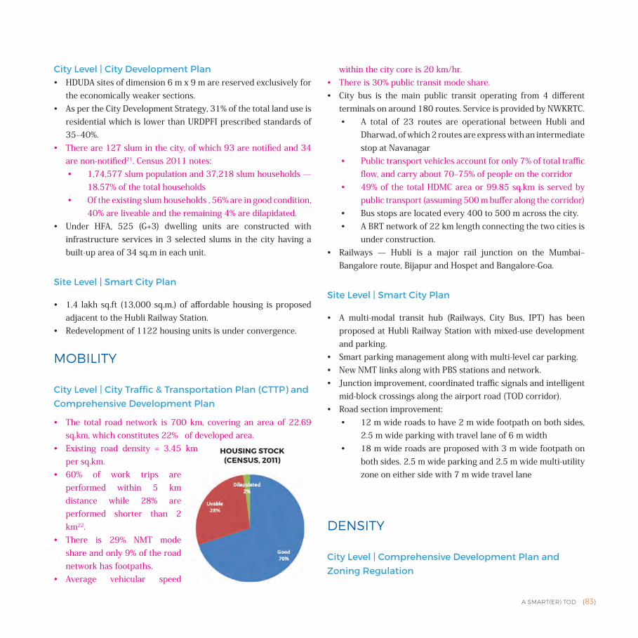
A SMART(ER) TOD {83}
City Level | City Development Plan• HDUDA sites of dimension 6 m x 9 m are reserved exclusively for
the economically weaker sections.• As per the City Development Strategy, 31% of the total land use is
residential which is lower than URDPFI prescribed standards of 35‒40%.
• There are 127 slum in the city, of which 93 are notified and 34 are non-notified21. Census 2011 notes: • 1,74,577 slum population and 37,218 slum households —
18.57% of the total households• Of the existing slum households , 56% are in good condition,
40% are liveable and the remaining 4% are dilapidated.• Under HFA, 525 (G+3) dwelling units are constructed with
infrastructure services in 3 selected slums in the city having a built-up area of 34 sq.m in each unit.
Site Level | Smart City Plan
• 1.4 lakh sq.ft (13,000 sq.m.) of affordable housing is proposed adjacent to the Hubli Railway Station.
• Redevelopment of 1122 housing units is under convergence.
MOBILITY
City Level | City Traffic & Transportation Plan (CTTP) and Comprehensive Development Plan
• The total road network is 700 km, covering an area of 22.69 sq.km, which constitutes 22% of developed area.
• Existing road density = 3.45 km per sq.km.
• 60% of work trips are performed within 5 km distance while 28% are performed shorter than 2 km22.
• There is 29% NMT mode share and only 9% of the road network has footpaths.
• Average vehicular speed
within the city core is 20 km/hr. • There is 30% public transit mode share.• City bus is the main public transit operating from 4 different
terminals on around 180 routes. Service is provided by NWKRTC.• A total of 23 routes are operational between Hubli and
Dharwad, of which 2 routes are express with an intermediate stop at Navanagar
• Public transport vehicles account for only 7% of total traffic flow, and carry about 70‒75% of people on the corridor
• 49% of the total HDMC area or 99.85 sq.km is served by public transport (assuming 500 m buffer along the corridor)
• Bus stops are located every 400 to 500 m across the city.• A BRT network of 22 km length connecting the two cities is
under construction. • Railways — Hubli is a major rail junction on the Mumbai‒
Bangalore route, Bijapur and Hospet and Bangalore-Goa.
Site Level | Smart City Plan
• A multi-modal transit hub (Railways, City Bus, IPT) has been proposed at Hubli Railway Station with mixed-use development and parking.
• Smart parking management along with multi-level car parking. • New NMT links along with PBS stations and network.• Junction improvement, coordinated traffic signals and intelligent
mid-block crossings along the airport road (TOD corridor).• Road section improvement:
• 12 m wide roads to have 2 m wide footpath on both sides, 2.5 m wide parking with travel lane of 6 m width
• 18 m wide roads are proposed with 3 m wide footpath on both sides. 2.5 m wide parking and 2.5 m wide multi-utility zone on either side with 7 m wide travel lane
DENSITY
City Level | Comprehensive Development Plan and Zoning Regulation
HOUSING STOCK (CENSUS, 2011)
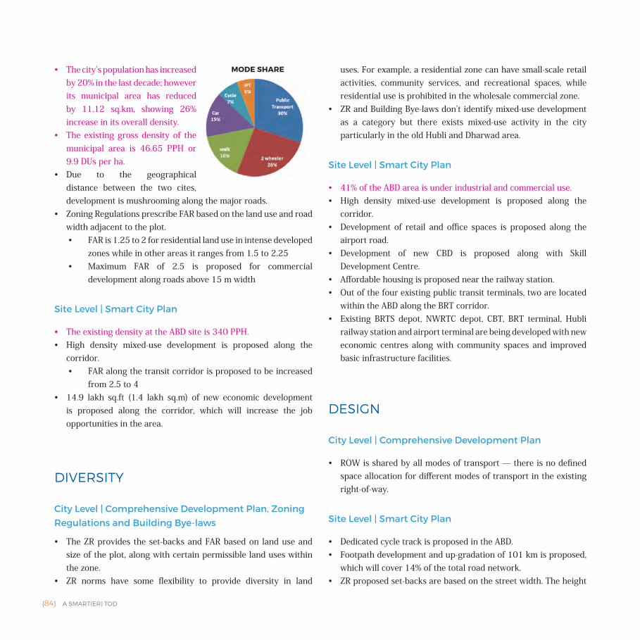
{84} A SMART(ER) TOD
• The city’s population has increased by 20% in the last decade; however its municipal area has reduced by 11.12 sq.km, showing 26% increase in its overall density.
• The existing gross density of the municipal area is 46.65 PPH or 9.9 DUs per ha.
• Due to the geographical distance between the two cites, development is mushrooming along the major roads.
• Zoning Regulations prescribe FAR based on the land use and road width adjacent to the plot. • FAR is 1.25 to 2 for residential land use in intense developed
zones while in other areas it ranges from 1.5 to 2.25 • Maximum FAR of 2.5 is proposed for commercial
development along roads above 15 m width
Site Level | Smart City Plan
• The existing density at the ABD site is 340 PPH. • High density mixed-use development is proposed along the
corridor.• FAR along the transit corridor is proposed to be increased
from 2.5 to 4• 14.9 lakh sq.ft (1.4 lakh sq.m) of new economic development
is proposed along the corridor, which will increase the job opportunities in the area.
DIVERSITY
City Level | Comprehensive Development Plan, Zoning Regulations and Building Bye-laws
• The ZR provides the set-backs and FAR based on land use and size of the plot, along with certain permissible land uses within the zone.
• ZR norms have some flexibility to provide diversity in land
uses. For example, a residential zone can have small-scale retail activities, community services, and recreational spaces, while residential use is prohibited in the wholesale commercial zone.
• ZR and Building Bye-laws don’t identify mixed-use development as a category but there exists mixed-use activity in the city particularly in the old Hubli and Dharwad area.
Site Level | Smart City Plan
• 41% of the ABD area is under industrial and commercial use.• High density mixed-use development is proposed along the
corridor. • Development of retail and office spaces is proposed along the
airport road.• Development of new CBD is proposed along with Skill
Development Centre.• Affordable housing is proposed near the railway station.• Out of the four existing public transit terminals, two are located
within the ABD along the BRT corridor. • Existing BRTS depot, NWRTC depot, CBT, BRT terminal, Hubli
railway station and airport terminal are being developed with new economic centres along with community spaces and improved basic infrastructure facilities.
DESIGN
City Level | Comprehensive Development Plan
• ROW is shared by all modes of transport — there is no defined space allocation for different modes of transport in the existing right-of-way.
Site Level | Smart City Plan
• Dedicated cycle track is proposed in the ABD.• Footpath development and up-gradation of 101 km is proposed,
which will cover 14% of the total road network. • ZR proposed set-backs are based on the street width. The height
MODE SHARE
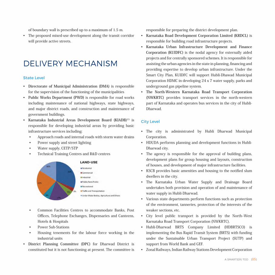
A SMART(ER) TOD {85}
of boundary wall is prescribed up to a maximum of 1.5 m.• The proposed mixed-use development along the transit corridor
will provide active streets.
DELIVERY MECHANISM
State Level
• Directorate of Municipal Administration (DMA) is responsible for the supervision of the functioning of the municipalities
• Public Works Department (PWD) is responsible for road works including maintenance of national highways, state highways, and major district roads, and construction and maintenance of government buildings.
• Karnataka Industrial Areas Development Board (KIADB)23 is responsible for developing industrial areas by providing basic infrastructure services including: • Approach roads and internal roads with storm water drains• Power supply and street lighting• Water supply, CETP/STP• Technical Training Centres and R&D centres
• Common Facilities Centres to accommodate Banks, Post Offices, Telephone Exchanges, Dispensaries and Canteens, Hotels & Hospitals
• Power Sub-Stations• Housing tenements for the labour force working in the
industrial units• District Planning Committee (DPC) for Dharwad District is
constituted but it is not functioning at present. The committee is
responsible for preparing the district development plan. • Karnataka Road Development Corporation Limited (KRDCL) is
responsible for building road infrastructure projects.• Karnataka Urban Infrastructure Development and Finance
Corporation (KUIDFC) is the nodal agency for externally aided projects and for centrally sponsored schemes. It is responsible for assisting the urban agencies in the state in planning, financing and providing expertise to develop urban infrastructure. Under the Smart City Plan, KUIDFC will support Hubli-Dhawad Municipal Corporation HDMC in developing 24 x 7 water supply, parks and underground gas pipeline system.
• The North-Western Karnataka Road Transport Corporation (NWKRTC) provides transport services in the north-western part of Karnataka and operates bus services in the city of Hubli-Dharwad.
City Level
• The city is administrated by Hubli Dharwad Municipal Corporation.
• HDUDA performs planning and development functions in Hubli-Dharwad city.
• The agency is responsible for the approval of building plans, development plans for group housing and layouts, construction of houses, and development of major infrastructure facilities.
• KSCB provides basic amenities and housing to the notified slum dwellers in the city.
• The Karnataka Urban Water Supply and Drainage Board undertakes both provision and operation of and maintenance of water supply in Hubli-Dharwad.
• Various state departments perform functions such as protection of the environment, tanneries, protection of the interests of the weaker sections, etc.
• City level public transport is provided by the North‒West Karnataka Road Transport Corporation (NWKRTC).
• Hubli-Dharwad BRTS Company Limited (HDBRTSCO) is implementing the Bus Rapid Transit System (BRTS) with funding under the Sustainable Urban Transport Project (SUTP) and support from World Bank and GEF.
• Zonal Railways, Indian Railway Stations Development Corporation
LAND-USE
{86} A SMART(ER) TOD
Limited (IRSDC) and Rail Land Development Authority (RLDA) are implementing the Hubli railway station redevelopment project.
Stakeholders for implementing SCP
• HDMC• KUWSDB• KUIDFC• HESCOM • Hubli-Dharwad BRTS Company Limited (HDBRTSCO) • MNRE & Solar Cities Programme • KREDEL • Department of Industries and Commerce• CEDOCK Dharwad• Deshpande Foundation• RUDSED Dharwad • Indian Railway Stations Development Corporation Limited
(IRSDC) • Rail Land Development Authority (RLDA) • Nathan & Nathan Consultants Private Limited. • DANLAW TECHNOLOGIES • SOFTTECH ENGINEERS PRIVATE LIMITED • WORLD BANK/DFID/IBI • Karvin Associates, AECOM, TCE, Black & Veatch, HCP, Jacobs,
iDeCK, Mahindra Acres, Hyder Consulting, Feedback Ventures, DIMTS
• Veolia, Suez, L&T, Tata Projects, ILFS Water, Subhash Projects • Marg Group, RR Parkon, L&T, Shoba, Embassy, Brigade, Prestige,
Hiranandani and Godrej Properties • DIMTS, Trimax, Schneider, Arya Omnitec, Continental, Siemens • L&T, HCC, Gammon, Shapoorji Pallonji, Oriental Construction,
ITNL • Emmvee Photovoltaic Power Private Ltd, U-Solar Clean Energy
Solutions Pvt. Ltd, Premier Solar Powertech Private Limited • ROLTA, HCL, L&T, Siemens, Bosch• TCS, HCL, Wipro, Infosys, Mindtree
CITY'S APPROACH TOWARDS TODThe ongoing development and the proposal for ABD suggest that the city is heading towards :
• Improving mobility infrastructure to promote public transit and NMT usage.• Presently the area is well served by the existing city bus
service, but traffic congestion on roads and poor pedestrian facilities are issues in the CBD area and the rest of the Old Hubli area.
• The SCP includes projects for a complete street network having footpath provision, MUZ and pedestrianised junctions along 12 m and 18 m wide roads. It has proposed junction improvement, coordinated traffic signals and intelligent mid-block crossings along the BRT corridor, as well as improving the green cover along the road by deputing an eco-battalion for its creation and maintenance. The proposed MUZ can also be used to accommodate IPT stands and vending areas.
• The various proposed projects will help the city to achieve the target of higher mode share for Public Transit (50% as per the CDP). It will be important for the city to ensure strong last mile connectivity through pedestrian & bicycle infrastructure and IPT. Active street frontages will also be critical for ensuring natural surveillance and safety. The city should scale pedestrian and bicycle infrastructure based on adjacent land use.
• Creation of economic activities along the transit corridor. This includes the new CBD development along with commercial hub development on existing city level transit nodes.• The idea is to develop new economic centres along with
community spaces and improve basic infrastructure facilities.
• Railway station redevelopment includes commercial development adjacent to the station area.
• The new commercial developments include: lake front redevelopment to generate recreational activities; trade pavilion and skill development centre and capacity building
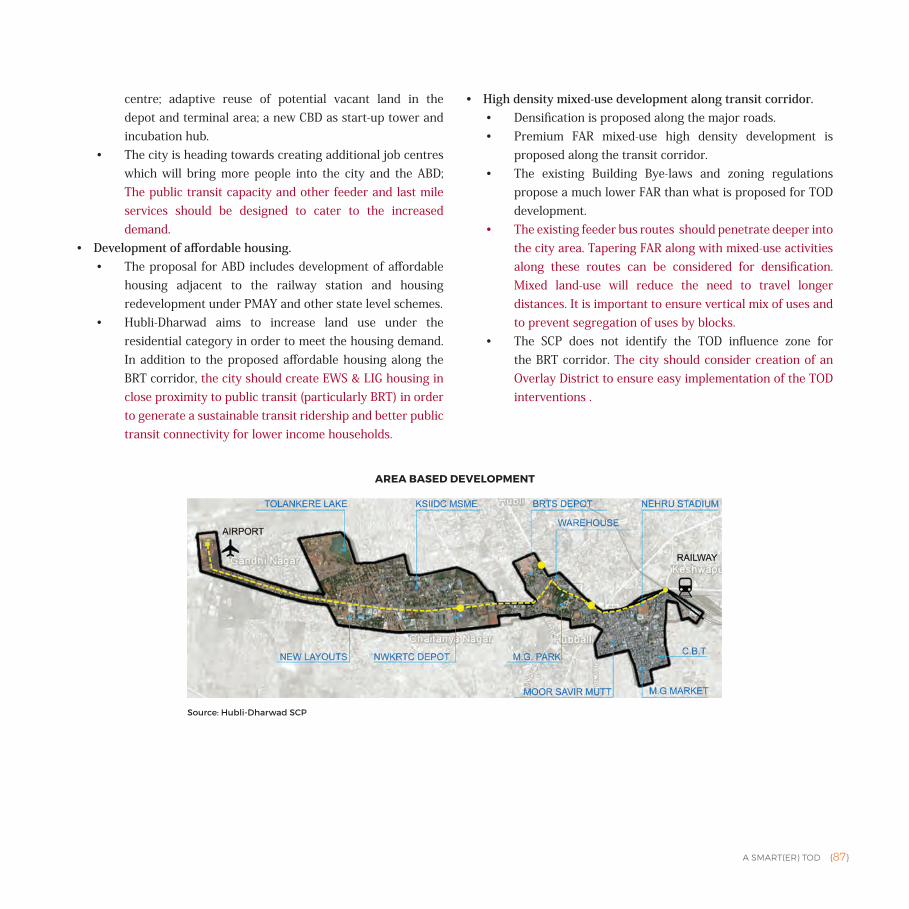
A SMART(ER) TOD {87}
centre; adaptive reuse of potential vacant land in the depot and terminal area; a new CBD as start-up tower and incubation hub.
• The city is heading towards creating additional job centres which will bring more people into the city and the ABD; The public transit capacity and other feeder and last mile services should be designed to cater to the increased demand.
• Development of affordable housing. • The proposal for ABD includes development of affordable
housing adjacent to the railway station and housing redevelopment under PMAY and other state level schemes.
• Hubli-Dharwad aims to increase land use under the residential category in order to meet the housing demand. In addition to the proposed affordable housing along the BRT corridor, the city should create EWS & LIG housing in close proximity to public transit (particularly BRT) in order to generate a sustainable transit ridership and better public transit connectivity for lower income households.
• High density mixed-use development along transit corridor.• Densification is proposed along the major roads. • Premium FAR mixed-use high density development is
proposed along the transit corridor.• The existing Building Bye-laws and zoning regulations
propose a much lower FAR than what is proposed for TOD development.
• The existing feeder bus routes should penetrate deeper into the city area. Tapering FAR along with mixed-use activities along these routes can be considered for densification. Mixed land-use will reduce the need to travel longer distances. It is important to ensure vertical mix of uses and to prevent segregation of uses by blocks.
• The SCP does not identify the TOD influence zone for the BRT corridor. The city should consider creation of an Overlay District to ensure easy implementation of the TOD interventions .
AREA BASED DEVELOPMENT
Source: Hubli-Dharwad SCP
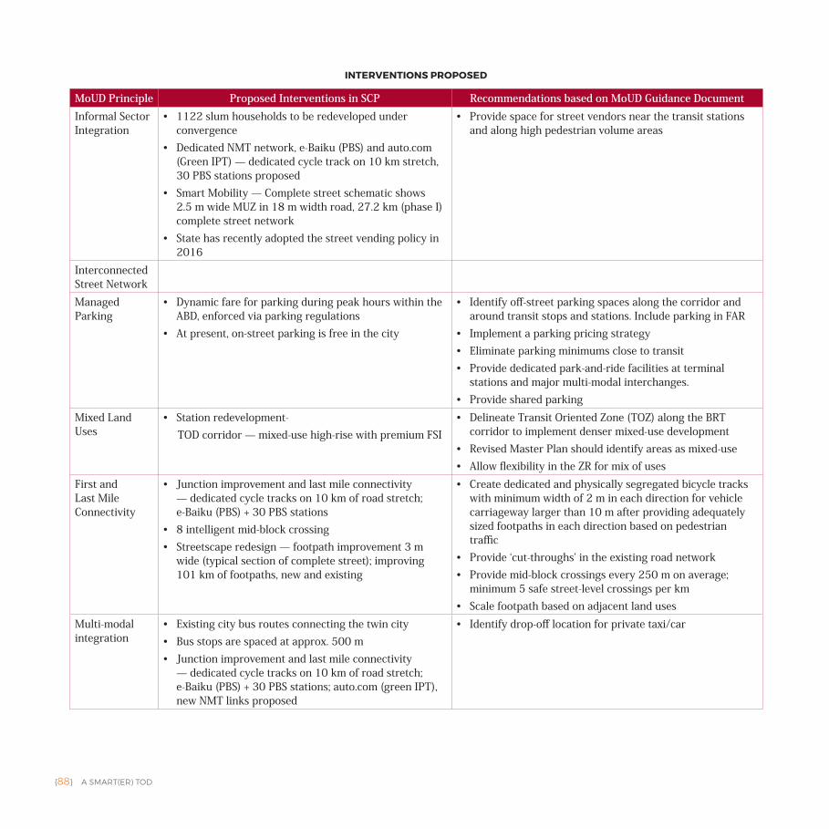
{88} A SMART(ER) TOD
MoUD Principle Proposed Interventions in SCP Recommendations based on MoUD Guidance Document Informal Sector Integration
• 1122 slum households to be redeveloped under convergence
• Dedicated NMT network, e-Baiku (PBS) and auto.com (Green IPT) — dedicated cycle track on 10 km stretch, 30 PBS stations proposed
• Smart Mobility — Complete street schematic shows 2.5 m wide MUZ in 18 m width road, 27.2 km (phase I) complete street network
• State has recently adopted the street vending policy in 2016
• Provide space for street vendors near the transit stations and along high pedestrian volume areas
Interconnected Street NetworkManaged Parking
• Dynamic fare for parking during peak hours within the ABD, enforced via parking regulations
• At present, on-street parking is free in the city
• Identify off-street parking spaces along the corridor and around transit stops and stations. Include parking in FAR
• Implement a parking pricing strategy• Eliminate parking minimums close to transit • Provide dedicated park-and-ride facilities at terminal
stations and major multi-modal interchanges.• Provide shared parking
Mixed Land Uses
• Station redevelopment- TOD corridor — mixed-use high-rise with premium FSI
• Delineate Transit Oriented Zone (TOZ) along the BRT corridor to implement denser mixed-use development
• Revised Master Plan should identify areas as mixed-use• Allow flexibility in the ZR for mix of uses
First and Last Mile Connectivity
• Junction improvement and last mile connectivity — dedicated cycle tracks on 10 km of road stretch; e-Baiku (PBS) + 30 PBS stations
• 8 intelligent mid-block crossing• Streetscape redesign — footpath improvement 3 m
wide (typical section of complete street); improving 101 km of footpaths, new and existing
• Create dedicated and physically segregated bicycle tracks with minimum width of 2 m in each direction for vehicle carriageway larger than 10 m after providing adequately sized footpaths in each direction based on pedestrian traffic
• Provide ‘cut-throughs’ in the existing road network• Provide mid-block crossings every 250 m on average;
minimum 5 safe street-level crossings per km• Scale footpath based on adjacent land uses
Multi-modal integration
• Existing city bus routes connecting the twin city• Bus stops are spaced at approx. 500 m• Junction improvement and last mile connectivity
— dedicated cycle tracks on 10 km of road stretch; e-Baiku (PBS) + 30 PBS stations; auto.com (green IPT), new NMT links proposed
• Identify drop-off location for private taxi/car
INTERVENTIONS PROPOSED
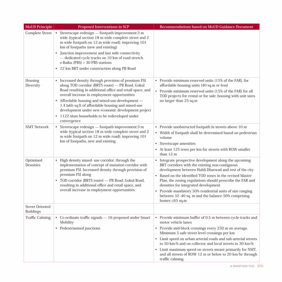
A SMART(ER) TOD {89}
MoUD Principle Proposed Interventions in SCP Recommendations based on MoUD Guidance Document Complete Street • Streetscape redesign — footpath improvement:3 m
wide (typical section 18 m wide complete street and 2 m wide footpath on 12 m wide road); improving 101 km of footpaths (new and existing)
• Junction improvement and last mile connectivity — dedicated cycle tracks on 10 km of road stretch. e-Baiku (PBS) + 30 PBS stations
• 22 km BRT under construction along PB Road
Housing Diversity
• Increased density through provision of premium FSI along TOD corridor (BRTS route) — PB Road, Gokul Road resulting in additional office and retail space, and overall increase in employment opportunities
• Affordable housing and mixed-use-development — 1.4 lakh sq.ft of affordable housing and mixed-use development under new economic development project
• 1122 slum households to be redeveloped under convergence
• Provide minimum reserved units (15% of the FAR), for affordable housing units (40 sq.m or less)
• Provide minimum reserved units (15% of the FAR) for all TOD projects for rental or for sale; housing with unit sizes no larger than 25 sq.m
NMT Network • Streetscape redesign — footpath improvement:3 m wide (typical section 18 m wide complete street and 2 m wide footpath on 12 m wide road); improving 101 km of footpaths, new and existing
• Provide unobstructed footpath in streets above 10 m• Width of footpath shall be determined based on pedestrian
volume• Streetscape amenities• At least 125 trees per km for streets with ROW smaller
than 12 mOptimised Densities
• High density mixed- use corridor, through the implementation of concept of mutation corridor with premium FSI. Increased density through provision of premium FSI along
• TOD corridor (BRTS route) — PB Road, Gokul Road, resulting in additional office and retail space, and overall increase in employment opportunities
• Integrate prospective development along the upcoming BRT corridors with the existing non-contiguous development between Hubli-Dharwad and rest of the city
• Based on the identified TOD zones in the revised Master Plan, the zoning regulations should prescribe the FAR and densities for integrated development
• Provide mandatory 50% residential units of size ranging between 32‒40 sq. m and the balance 50% comprising homes ≤65 sq.m
Street Oriented BuildingsTraffic Calming • Co-ordinate traffic signals — 16 proposed under Smart
Mobility• Pedestrianised junctions
• Provide minimum buffer of 0.5 m between cycle tracks and motor vehicle lanes
• Provide mid-block crossings every 250 m on average. Minimum 5 safe street-level crossings per km
• Limit speed on urban arterial roads and sub-arterial streets to 50 km/h and on collector and local streets to 30 km/h
• Limit maximum speed on streets meant primarily for NMT, and all streets of ROW 12 m or below to 20 km/hr through traffic calming
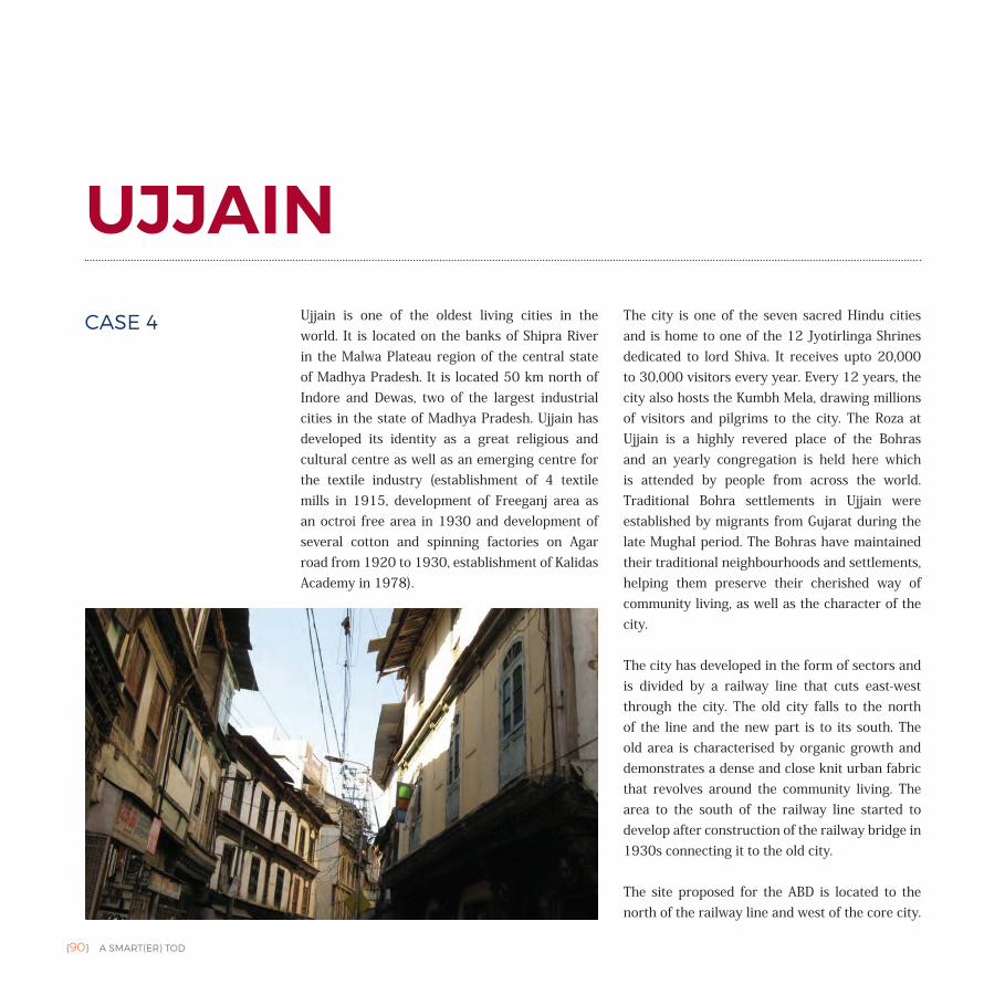
{90} A SMART(ER) TOD
UJJAINUjjain is one of the oldest living cities in the world. It is located on the banks of Shipra River in the Malwa Plateau region of the central state of Madhya Pradesh. It is located 50 km north of Indore and Dewas, two of the largest industrial cities in the state of Madhya Pradesh. Ujjain has developed its identity as a great religious and cultural centre as well as an emerging centre for the textile industry (establishment of 4 textile mills in 1915, development of Freeganj area as an octroi free area in 1930 and development of several cotton and spinning factories on Agar road from 1920 to 1930, establishment of Kalidas Academy in 1978).
The city is one of the seven sacred Hindu cities and is home to one of the 12 Jyotirlinga Shrines dedicated to lord Shiva. It receives upto 20,000 to 30,000 visitors every year. Every 12 years, the city also hosts the Kumbh Mela, drawing millions of visitors and pilgrims to the city. The Roza at Ujjain is a highly revered place of the Bohras and an yearly congregation is held here which is attended by people from across the world. Traditional Bohra settlements in Ujjain were established by migrants from Gujarat during the late Mughal period. The Bohras have maintained their traditional neighbourhoods and settlements, helping them preserve their cherished way of community living, as well as the character of the city.
The city has developed in the form of sectors and is divided by a railway line that cuts east-west through the city. The old city falls to the north of the line and the new part is to its south. The old area is characterised by organic growth and demonstrates a dense and close knit urban fabric that revolves around the community living. The area to the south of the railway line started to develop after construction of the railway bridge in 1930s connecting it to the old city.
The site proposed for the ABD is located to the north of the railway line and west of the core city.
CASE 4
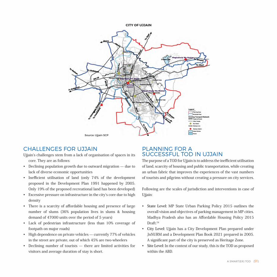
A SMART(ER) TOD {91}
CHALLENGES FOR UJJAINUjjain's challenges stem from a lack of organisation of spaces in its
core. They are as follows:• Declining population growth due to outward migration — due to
lack of diverse economic opportunities• Inefficient utilisation of land (only 74% of the development
proposed in the Development Plan 1991 happened by 2005. Only 19% of the proposed recreational land has been developed)
• Excessive pressure on infrastructure in the city's core due to high density
• There is a scarcity of affordable housing and presence of large number of slums (36% population lives in slums & housing demand of 47000 units over the period of 5 years)
• Lack of pedestrian infrastructure (less than 10% coverage of footpath on major roads)
• High dependence on private vehicles — currently 77% of vehicles in the street are private, out of which 45% are two-wheelers
• Declining number of tourists — there are limited activities for visitors and average duration of stay is short.
PLANNING FOR A SUCCESSFUL TOD IN UJJAINThe purpose of a TOD for Ujjain is to address the inefficient utilisation of land, scarcity of housing and public transportation, while creating an urban fabric that improves the experiences of the vast numbers of tourists and pilgrims without creating a pressure on city services.
Following are the scales of jurisdiction and interventions in case of Ujjain:
• State Level: MP State Urban Parking Policy 2015 outlines the overall vision and objectives of parking management in MP cities. Madhya Pradesh also has an Affordable Housing Policy 2015 Draft.24
• City Level: Ujjain has a City Development Plan prepared under JnNURM and a Development Plan Book 2021 prepared in 2005. A significant part of the city is preserved as Heritage Zone.
• Site Level: In the context of our study, this is the TOD as proposed within the ABD.
CITY OF UJJAIN
Source: Ujjain SCP
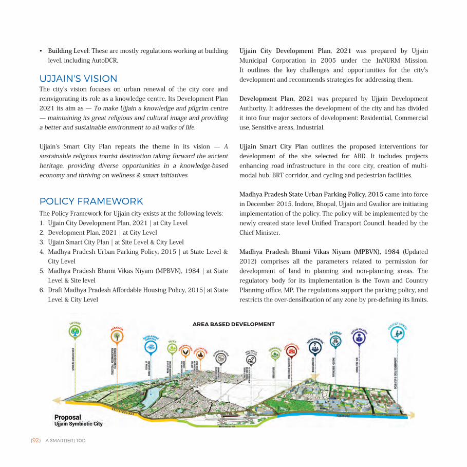
{92} A SMART(ER) TOD
• Building Level: These are mostly regulations working at building level, including AutoDCR.
UJJAIN'S VISIONThe city's vision focuses on urban renewal of the city core and reinvigorating its role as a knowledge centre. Its Development Plan 2021 its aim as — To make Ujjain a knowledge and pilgrim centre — maintaining its great religious and cultural image and providing a better and sustainable environment to all walks of life.
Ujjain's Smart City Plan repeats the theme in its vision — A sustainable religious tourist destination taking forward the ancient heritage, providing diverse opportunities in a knowledge-based economy and thriving on wellness & smart initiatives.
POLICY FRAMEWORKThe Policy Framework for Ujjain city exists at the following levels:1. Ujjain City Development Plan, 2021 | at City Level 2. Development Plan, 2021 | at City Level3. Ujjain Smart City Plan | at Site Level & City Level4. Madhya Pradesh Urban Parking Policy, 2015 | at State Level &
City Level5. Madhya Pradesh Bhumi Vikas Niyam (MPBVN), 1984 | at State
Level & Site level6. Draft Madhya Pradesh Affordable Housing Policy, 2015| at State
Level & City Level
Ujjain City Development Plan, 2021 was prepared by Ujjain Municipal Corporation in 2005 under the JnNURM Mission. It outlines the key challenges and opportunities for the city's development and recommends strategies for addressing them.
Development Plan, 2021 was prepared by Ujjain Development Authority. It addresses the development of the city and has divided it into four major sectors of development: Residential, Commercial use, Sensitive areas, Industrial.
Ujjain Smart City Plan outlines the proposed interventions for development of the site selected for ABD. It includes projects enhancing road infrastructure in the core city, creation of multi-modal hub, BRT corridor, and cycling and pedestrian facilities.
Madhya Pradesh State Urban Parking Policy, 2015 came into force in December 2015. Indore, Bhopal, Ujjain and Gwalior are initiating implementation of the policy. The policy will be implemented by the newly created state level Unified Transport Council, headed by the Chief Minister.
Madhya Pradesh Bhumi Vikas Niyam (MPBVN), 1984 (Updated 2012) comprises all the parameters related to permission for development of land in planning and non-planning areas. The regulatory body for its implementation is the Town and Country Planning office, MP. The regulations support the parking policy, and restricts the over-densification of any zone by pre-defining its limits.
AREA BASED DEVELOPMENT
A SMART(ER) TOD {93}
Draft Madhya Pradesh Affordable Housing Policy, 2015 was prepared by the Urban Development and Environment Department of the Government of Madhya Pradesh. It follows the Housing for All mission. The policy is applicable to municipal areas as notified by the government.
STRATEGIES FOR TOD/INTEGRATED DESIGNHOUSING
City Level | City Development Plan, Development Plan 2021 and Smart City Plan
• According to Census 2011, the city has a population of 5,15,215 and 1.65 Lakh (or 32.1%) of this population lives in 169 slums.
• Large amount of population has chosen unauthorised colonies for housing in the absence of supply of formal affordable housing options.
• Expected housing requirement by 2022 is 47,582 housing units (35,492 for accommodating slum dwelling households and 12,087 for others).
• 45% of the total developed land is reserved for residential development that accounts to 37 sq.km. of the city area.
• 74% of the area identified for development has been actually utilised.
• Core city is characterised by organic pattern of narrow streets. • Most of the slums in the city are concentrated in the northern
part of the city.• The city continues to grow in the south-western parts due to its
proximity to Indore and Dewas.• Site proposed for ABD is located in the northern part of the city
on government owned land. It attempts to address the gaps in housing through:• Artha Kshetra — Economic hub
• 1385 affordable housing units and 3325 other housing units within the Economic Hub
• 1842 affordable housing units and 4148 other housing units within the Knowledge Hub
• Ashray — Slum/Mill Workers/Affordable Housing • Slum Rehabilitation under PMAY for 6114 households
in 30 slums • 457 affordable housing units • 823 other category housing units • 5 working women hostels, 5 dormitories and night
shelters • 1320 units under BSUP 750 plots/units by UDA • 1026 DUs under RAY to be approved by GoI25
• Faster building plan approval through commissioning of Automated Building Plan Approval System (ABPAS) — average approval time reduced from 60 to 15 days.
MOBILITY
State Level | Madhya Pradesh State Urban Parking Policy, 2015
• Inner city struggles with unorganised street space and on-street parking.
• Madhya Pradesh Parking Policy aims to reduce the dependence on private vehicles and private vehicle ownership through: • Differential pricing and availability of parking according to
the value of land it is on• Enhancing public transit and access to public transit by
integrating parking with the public transit system through multi-modal hubs and park-and-ride
• Better use of street space by minimising on-street parking and increasing off-street parking, built with the help of private sector
• Integrating technology for efficient parking management
City Level | City Development Plan and Development Plan 2021
• 348.73 km of total road network.• Average trip length is 3.8 km to 4.4 km excluding walk trips.• Public transit fleet size is 139 buses (49 buses with GPS tracking
{94} A SMART(ER) TOD
installed) — 0.26 buses per 1000 people.• Public transit route length is 75 km (covering 10 routes).• Induction of 100 e-rickshaws and 1500 CNG fuelled autos as
sustainable IPT mode.• About 10% of streets have NMT Infrastructure.• Inner city streets cannot be widened due to lack of space.• On-street parking to be reduced on inner city streets.• Proposed widening of all major streets in the city to accommodate
the increasing traffic congestion:• 279.55 km of existing roads to be redeveloped• 69.18 km of new roads to be developed with road user
facilities• Improving the surface conditions of the roads to withstand all
weather conditions by 2021.• Channelisers, traffic islands, traffic signals, dividers, lane
separators and traffic police control to be shall be introduced at all important junctions based on a ‘Traffic Management Plan’.
Site Level | Smart City Plan
• 51.14 km of street in the ABD.• 7.68 km of public transit route.• A 5.2 km BRTS has been proposed with
• Segregated bus lanes• Cycle track, bicycle docking stations• Pedestrian paths• Multi-function zones• Pedestrian friendly active frontage zones
• Multi-Modal Transit Hub has been proposed adjacent to Ujjain railway station. It will integrate bus, rail, NMT and cars. It includes 5 bays BRTS transfer bays.
• Incentive for mixed-use TOD development on 114 acres of net TOD area, generating revenue from sale of premium on FAR.
• Pedestrian Only — Aradhana Path 5.68 km • 2400 ECS parking spaces (with smart parking management) • 50 e-rickshaws for IPT• Public Bike Share with 400 bikes
• Pedestrian Only — Dharowar Path 2.1 km. • Parivartan Path — TOD Corridor 5.2 km of sidewalks.
DENSITY
State Level | Madhya Pradesh Bhumi Vikas Niyam (MPBVN), 1984 (updated in 2012)
• The density is tied to FAR with minimum 0.75 FAR for the density of 125 PPH.
City Level | Development Plan 2021
• Density has increased from 3913 per sq.km in 1991 to 5539 per sq.km in 2011.
Site Level | Smart City Plan and Madhya Pradesh Bhumi Vikas Niyam (MPBVN), 1984 (updated in 2012)
• 340 acres of land in the ABD is vacant.• Existing net residential density of 708 PPH.• Existing parks of 2.41 acres.• 322 acres of religious land used for Kumbh Mela.• Proposed Knowledge Hub and Economic Hub in TOD will
generate 18450 new jobs.• University for Sanskrit and medical college proposed to be
established in the Knowledge Hub.• Knowledge Hub and Economic Hub, will be located on land that
is currently vacant and owned by the government.• Knowledge and Economic hub have been proposed as walkable
TOD communities connected to the BRT corridor.• The redevelopment area in the ABD, covering 34.47% of the
land (91.77 acres), will be developed to support mixed-use, mixed-income and high density (residential density of 375 DUs per ha).
• Proposed Multi-Modal Transit Hub will have:• 36100 sq.m of retail commercial space• 20000 sq.m of government office space• 2050 new jobs
• Total open space and parks proposed — 88.74 acres• Vatika and Mahakal Garden — 35.92 acres• Lake Restoration and Water Front Development — 23.86
acres
A SMART(ER) TOD {95}
• Vrindavan — 28.96 acres of multi-use open space• Building Bye-laws tie road width to the FAR.
DIVERSITY
State Level | Madhya Pradesh Bhumi Vikas Niyam (MPBVN), 1984
• Recommends ensuring planning for creation of employment centres within TOD zones.
City Level | Development Plan 2021
• Nearly 90% of the employment in the city is through tertiary sector.
• City has mixed-use along many main streets. • Bohra settlements in the city also demonstrate mixed-use as
many of their traditional houses have commercial activities at the ground level and residential on the upper levels.
Site Level | Smart City Plan and Madhya Pradesh Bhumi Vikas Niyam (MPBVN), 1984
• 3000 sq.m of dedicated street vending space.• Mixed-use proposed as part of the Knowledge Hub and Economic
Hub in the TOD. • Proposed Multi-modal Transit Hub to integrate commercial and
office space.• Diversity in types of housing proposed to be included in the ABD
-affordable housing, dormitories, night shelters.
DESIGN
State Level | Madhya Pradesh Bhumi Vikas Niyam, 1984
• It includes street design guidelines that comprehensively outline
the means of expanding and improving NMT facilities, public spaces and travel demand management.
City Level | Development Plan 2021
• There is no new development in the city core; only residential and retail activities are proposed near the railways station.
• No development zone has been marked to preserve the built heritage and open spaces in the city; this includes the Mela ground. Most of the newer development is primarily proposed along the ring road towards the south due to the proximity to Dewas and Indore.
• Dedicated zone for religious activities has been proposed to be situated along the Shipra River.
• Modification in the street design (road section) has been proposed to create pedestrian friendly streets and to increase walk ability. According to the Smart City Plan, the carriageway will reduce in the heritage zone to accommodate sidewalks and additional lanes for NMT.
• Duplex houses have been provided for in-situ redevelopment under "Apni Zameen Apni Chhat".
Site Level | Smart City Plan
• Streets within the ABD will be redesigned to make room for NMT infrastructure along the 5.2 km of BRT corridor.
• Complete street design for the neighbourhood of the temple area. • Pedestrian friendly active front age zones has been proposed.• Creation of 25,100 new jobs under various sectors is expected.• Ujjain Municipal Corporation has implemented the automation
of the building plan approval process by introducing AutoDCR system. The process reduces the human interfaces in the approval and faster the process by five times as compared to normal approval.
{96} A SMART(ER) TOD
DELIVERY MECHANISM
Ujjain has implemented the following e-governance reforms from JnNURM.
Establishment of Ujjain City Transport Services Pvt. Ltd. (UCTSL), which introduced organised public transport operations through PPP.
ULB Level
• Shift to accrual based double entry accounting• Computerisation of property tax collection with online payment
system• Internal earmarking of funds for services to urban poor• Birth and death registration and health programmes have been
implemented• AutoDCR Building Approval System is in place; however, it is
being updated according to the new Building Bye-laws• Special power for modification of building height in reference
local area density for low-income housing and public activities is given to town and country planning department
State Level
• 74th CAA (transfer 12 scheduled functions)• 74th CAA (constitution of DPC)• Transfer — City Planning Function• Transfer — Water Supply & Sanitation• Reform in Rent Control• Stamp Duty rationalisation to 5%• Repeal of ULCRA• Enactment of Community Participation Law• Enactment of Public Disclosure Law
Optional Reforms
• Revision of Building Bye-laws — streamlining the approval process
• Revision of Building Bye-laws — to make rainwater harvesting mandatory
• Earmarking 25% developed land in all housing projects for EWS/LIG
• Simplification of legal and procedural framework for conversion of agricultural land for non-agricultural purposes
• Bye-laws on reuse of recycled water• Administrative reforms• Structural reforms• Encouraging public participation
The SPV includes representatives from
• Ujjain City Administration • Ujjain Municipal Corporation • Ujjain Development Authority• Mayors Nominee• MP Public Works Department• Public Health Engineering Department• Electricity DISCOM• Regional Transport Officer• Town and Country Planning • Madhya Pradesh Urban Development Company Limited• Government of India representative nominated by MoUD and• Independent directors from various sectors(Vendors, Contractors)
Resources for SCP:
• Government of India (GOI) under SCM• Convergence with Grants GoI/GoMP• Corporate Social Responsibility• Ujjain Infrastructure Development Fund • Dedicated Urban Transport Fund• Atal Mission For Rejuvenation and Urban Transformation
(AMRUT)• Pradhaan Mantri Awas Yojana (PMAY) Under Housing For All
(HFA) Mission• Swachh Bharat Mission (SBM)• Solar City Scheme of Ministry of New & Renewable Energy• Start Up India & Digital India• Jan Sahyog (Community Contribution)• Public Private Partnership
A SMART(ER) TOD {97}
CITY'S APPROACH TOWARDS TODCity's approach to TOD can be summarised as below:Appropriately located ABD and development of TOD• Southern part of the city has some planned neighbourhoods and
shows growth as a result of better quality of infrastructure and due to its proximity to Indore and Dewas. As a result, the northern part of the city has become the less desirable.
• The site for the ABD is located in the northern part, bringing essential investment in infrastructure for the area. The site includes existing slums and land occupied by defunct cotton mills.
• Development of the area will alleviate the issues caused due to lack of basic infrastructure.
• Since the area is poorer as compared to the southern part of the city, proposed investments in the knowledge and economic hub will lead to inclusive growth by creating opportunities for education, jobs, housing and mobility for some of the poorest households in the city.
Creating an environment for diversification of the economy• Currently nearly 90% of the workers are engaged in tertiary
sector related to tourism. The city faces outward migration due to the lack of diverse job opportunities in the city. A knowledge hub with a Sanskrit University and a medical college and an Economic Hub with Skill Development Centre and commercial activities has been proposed to address this issue.
• The creation of variety of job and skill development opportunities must be complemented with strong accessibility options. Even though the development is located within 1 km of the BRT corridor, accessibility can be enhanced by providing last mile connectivity option to the destinations within the development.
Providing affordable housing for the large slum population, with access to public transit• Lower income households depend on public transit for mobility.
Even though the SCP places all the affordable housing units is within 1 km of the BRT corridor, there is an opportunity to improve the last mile connectivity of all these housing units. Currently the NMT and pedestrian enhancement are limited to the BRT corridor. These should be extended into the development to reach all households.
Urban renewal of core city to alleviate congestion and to improve experiences for citizens and tourists • As a religious centre, the city receives over 3 million every year
(6 times its population), yet it has poor NMT Infrastructure and public transit system (0.26 buses per 1000 people). It urgently needs to address the issues created by poor quality infrastructure that is supporting a high number of footfall. Proposed compact development, the BRT and the various NMT enhancements within the ABD will contribute to this. However, the city needs to further enhance walkability by providing NMT infrastructure throughout the ABD and by maintaining smaller block size.
• The proposed pedestrian only paths — Dharowar Path and Aradhana Path are not connected with the railway multi-modal hub station and the BRT corridor. Further, they also include large space for private vehicle parking. This will lead to a greater use of private vehicles in accessing these paths and the temples they connect. It will generate higher congestion in the core city. Dharowar Path and Aradhana Path must have pedestrian, NMT and IPT based connectivity from the modes of mass transit to reduce dependence on private vehicles. Specific area within the core city can also be reserved for pedestrians, enhancing accessibility for the tourists. Any parking provided in the core city should be priced according to the market value of the land.
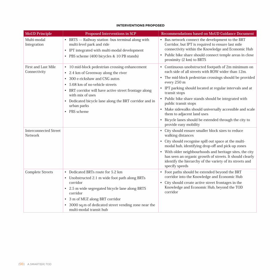
{98} A SMART(ER) TOD
MoUD Principle Proposed Interventions in SCP Recommendations based on MoUD Guidance Document Multi-modal Integration
• BRTS — Railway station -bus terminal along with multi-level park and ride
• IPT integrated with multi-modal development• PBS scheme (400 bicycles & 10 PB stands)
• Bus network connect the development to the BRT Corridor, but IPT is required to ensure last mile connectivity within the Knowledge and Economic Hub
• Public bike share should connect temple areas in close proximity (2 km) to BRTS
First and Last Mile Connectivity
• 10 mid-block pedestrian crossing enhancement• 2.4 km of Greenway along the river• 300 e-rickshaw and CNG autos • 5.68 km of no-vehicle streets• BRT corridor will have active street frontage along
with mix of uses• Dedicated bicycle lane along the BRT corridor and in
urban parks• PBS scheme
• Continuous unobstructed footpath of 2m minimum on each side of all streets with ROW wider than 12m.
• The mid-block pedestrian crossings should be provided every 250 m
• IPT parking should located at regular intervals and at transit stops
• Public bike share stands should be integrated with public transit stops
• Make sidewalks should universally accessible and scale them to adjacent land uses
• Bicycle lanes should be extended through the city to provide easy mobility
Interconnected Street Network
• City should ensure smaller block sizes to reduce walking distances
• City should recognise spill out space at the multi-modal hub, identifying drop-off and pick-up zones
• With older neighbourhoods and heritage sites, the city has seen an organic growth of streets. It should clearly identify the hierarchy of the variety of its streets and specify speeds
Complete Streets • Dedicated BRTs route for 5.2 km• Unobstructed 2.1 m wide foot path along BRTs
corridor • 2.5 m wide segregated bicycle lane along BRTS
corridor• 3 m of MUZ along BRT corridor • 3000 sq.m of dedicated street vending zone near the
multi-modal transit hub
• Foot paths should be extended beyond the BRT corridor into the Knowledge and Economic Hub
• City should create active street frontages in the Knowledge and Economic Hub, beyond the TOD corridor
INTERVENTIONS PROPOSED
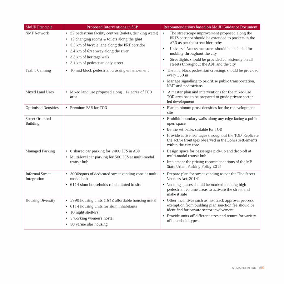
A SMART(ER) TOD {99}
MoUD Principle Proposed Interventions in SCP Recommendations based on MoUD Guidance Document NMT Network • 22 pedestrian facility centres (toilets, drinking water)
• 12 changing rooms & toilets along the ghat• 5.2 km of bicycle lane along the BRT corridor• 2.4 km of Greenway along the river• 3.2 km of heritage walk• 2.1 km of pedestrian only street
• The streetscape improvement proposed along the BRTS corridor should be extended to pockets in the ABD as per the street hierarchy
• Universal Access measures should be included for mobility throughout the city
• Streetlights should be provided consistently on all streets throughout the ABD and the city
Traffic Calming • 10 mid-block pedestrian crossing enhancement • The mid-block pedestrian crossings should be provided every 250 m
• Manage signalling to prioritise public transportation, NMT and pedestrians
Mixed Land Uses • Mixed land use proposed along 114 acres of TOD area
• A master plan and interventions for the mixed-use TOD area has to be prepared to guide private sector led development
Optimised Densities • Premium FAR for TOD • Plan minimum gross densities for the redevelopment site
Street Oriented Building
• Prohibit boundary walls along any edge facing a public open space
• Define set-backs suitable for TOD • Provide active frontages throughout the TOD. Replicate
the active frontages observed in the Bohra settlements within the city core.
Managed Parking • 6 shared car parking for 2400 ECS in ABD• Multi-level car parking for 500 ECS at multi-modal
transit hub
• Design space for passenger pick-up and drop-off at multi-modal transit hub
• Implement the pricing recommendations of the MP State Urban Parking Policy 2015
Informal Street Integration
• 3000sqmts of dedicated street vending zone at multi-modal hub
• 6114 slum households rehabilitated in-situ
• Prepare plan for street vending as per the 'The Street Vendors Act, 2014'
• Vending spaces should be marked in along high pedestrian volume areas to activate the street and make it safe
Housing Diversity • 5990 housing units (1842 affordable housing units) • 6114 housing units for slum inhabitants• 10 night shelters• 5 working women’s hostel• 50 vernacular housing
• Other incentives such as fast track approval process, exemption from building plan sanction fee should be identified for private sector involvement
• Provide units off different sizes and tenure for variety of household types
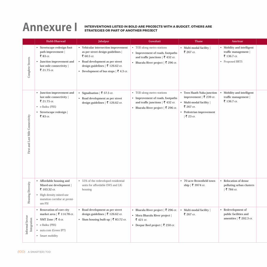
{100} A SMART(ER) TOD
Hubli-Dharwad Jabalpur Guwahati Thane Amritsar Kochi Nagpur Chennai Chandigarh New Town Kolkata
Com
plet
e St
reet
s
• Streetscape redesign foot-path improvement | ` 83 cr.
• Junction improvement and last mile connectivity | ` 21.75 cr.
• Vehicular intersection improvement as per street design guidelines | ` 60.5 cr.
• Road development as per street design guidelines | ` 126.62 cr.
• Development of bus stops | ` 4.3 cr.
• TODalongmetrostations
• Improvement of roads, footpaths and traffic junctions | ` 432 cr.
• Bharalu River project | ` 296 cr.
• Multi-modal facility | ` 267 cr.
• Mobility and intelligent traffic management | ` 136.7 cr.
• ProposedBRTS
• Water transport infra-structure | ` 42 cr.
• Project TenderSURE | ` 220 cr. • Differently abled foot path | ` 15.84 cr.
• Bicycle lanes | ` 15.84 cr.
• MetroproposedincityisalongedgeofABD
• Redesignof20roadsascompletestreets
• Annual cost of pedestrianisation of Jan Marg on weekend | ` 0.73 cr.
• Dedicated cycle tracks shared with footpath | ` 2.8 cr.
• Footpath | ` 7.2 cr.
• MetroproposedalongtheTOD
• ISBTexistsintheABD
• Urban design — public plaza — de-sign for FoW plazas | ` 37.92 cr.
• Pedestrian friendly pathways and non vehicle streets/zones | ` 40.9 cr.
• Dedicated bi-cycle lanes along the roads | ` 180 cr.
• Upcomingmetrorailway(Garia-AirportMetro)andmono-railprojects
• Vending zone | ` 2.7 cr.
Firs
t and
Las
t Mile
Con
nect
ivity
• Junction improvement and last mile connectivity | ` 21.75 cr.
• e-Baiku(PBS)
• Streetscape redesign | ` 83 cr.
• Signalisation | ` 57.5 cr.
• Road development as per street design guidelines | ` 126.62 cr.
• TODalongmetrostations
• Improvement of roads, footpaths and traffic junctions | ` 432 cr.
• Bharalu River project | ` 296 cr.
• Teen Haath Naka junction improvement | ` 239 cr.
• Multi-modal facility | ` 267 cr.
• Pedestrian improvement | ` 23 cr.
• Mobility and intelligent traffic management | ` 136.7 cr.
• Open space corridor linking DH ground to Mangalavanam | ` 9 cr.
• Walkway from EKM jetty to metro station | ` 9 cr.
• Standard footpath including signages | ` 28.53 cr.
• World class arterial roads | ` 52.87 cr.
• Relaying of roads | ` 42 cr.
• Relaying of roads aesthetic and improved urban design pedestrian facilities with street fur-niture, boulevards and urban greenery (main roads) | ` 16.5 cr.
• Project Nirmal Nag River | ` 150 cr.
• BandararoadTODPrecinctInfluenceArea—IPTparkingwithin150mofmetrostation
• Project TenderSURE | ` 220 cr.
• Project Share-a-bike (PPP)
• Traffic calming of streets| ` 7.43 cr.
• Differently abled foot path | ` 15.84 cr.
• Bicycle lanes | ` 15.84 cr.
• Cycle sharing system with ICT application | ` 0.15 cr.
• Dedicated cycle tracks shared with footpath | ` 2.8 cr.
• e-rickshaws | ` 1.15 cr.
• Public bike sharing | ` 4.22 cr.
• Footpath | ` 7.2 cr.
• Dedicated bi-cycle lanes along the roads | ` 180 cr.
• Bicycle sharing pro-gramme | ` 1 cr.
• Pedestrian friendly pathways and non vehicle streets/zones | ` 40.9 cr.
Hou
sing
Div
ersi
ty
• Affordable housing and Mixed-use development | ` 103.32 cr.
• Highdensitymixed-usemutationcorridoratpremi-umFSI
• 55%oftheredevelopedresidentialunitsforaffordableEWSandLIGhousing
• 70 acre Brownfield town-ship | ` 3974 cr.
• Relocation of dense polluting urban clusters | ` 784 cr.
• Project HOME SWEET HOME | ` 30 cr.
• SuyojitPBB:focusoninclusiveplanningbyresolvinglanduseconflictusingTPS
• Transitorientedplanneddevelop-mentmodel(FSI=3.0),buildingheight(Ground+9storeys)asperDraftTODPolicy
• Residential-affordable housing
• Hostel facility | ` 121.39 cr.
Info
rmal
Sec
tor
Inte
grat
ion
• Renovation of core city market area | ` 114.78 cr.
• NMT Zone | ` 4 cr.
• e-Baiku(PBS)
• auto.com(GreenIPT)
• Smartmobility
• Road development as per street design guidelines | ` 126.62 cr.
• Slum housing built-up | ` 83.72 cr.
• Bharalu River project | ` 296 cr.
• Mora Bharalu River project | ` 421 cr.
• Deepar Beel project | ` 250 cr.
• Multi-modal facility | ` 267 cr.
• Redevelopment of public facilities and amenities | ` 202.3 cr.
• Standard hawker zones in Fort Kochi | ` 5 cr.
• Integrated redevelop-ment of slum housing | ` 141.4 cr.
• Project TenderSURE | ` 220 cr.
• BandararoadTODPrecinctInfluenceArea—IPTparkingwithin150mofmetrostation
• Project HOME SWEET HOME | ` 30 cr.
• Redesignof20roadsascompletestreets
• e-rickshaws | ` 1.15 cr.
• Urban design — public plaza — de-sign of FoW plazas | ` 37.92 cr.
• ToTo, auto smart stands | ` 6 cr.
• Vending zones | ` 2.7 cr.
Annexure I INTERVENTIONS LISTED IN BOLD ARE PROJECTS WITH A BUDGET, OTHERS ARE STRATEGIES OR PART OF ANOTHER PROJECT
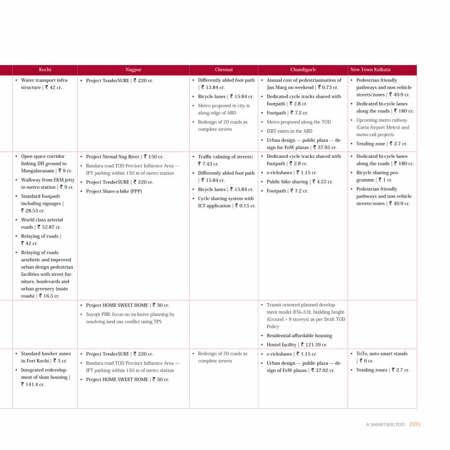
A SMART(ER) TOD {101}
Hubli-Dharwad Jabalpur Guwahati Thane Amritsar Kochi Nagpur Chennai Chandigarh New Town Kolkata
Com
plet
e St
reet
s
• Streetscape redesign foot-path improvement | ` 83 cr.
• Junction improvement and last mile connectivity | ` 21.75 cr.
• Vehicular intersection improvement as per street design guidelines | ` 60.5 cr.
• Road development as per street design guidelines | ` 126.62 cr.
• Development of bus stops | ` 4.3 cr.
• TODalongmetrostations
• Improvement of roads, footpaths and traffic junctions | ` 432 cr.
• Bharalu River project | ` 296 cr.
• Multi-modal facility | ` 267 cr.
• Mobility and intelligent traffic management | ` 136.7 cr.
• ProposedBRTS
• Water transport infra-structure | ` 42 cr.
• Project TenderSURE | ` 220 cr. • Differently abled foot path | ` 15.84 cr.
• Bicycle lanes | ` 15.84 cr.
• MetroproposedincityisalongedgeofABD
• Redesignof20roadsascompletestreets
• Annual cost of pedestrianisation of Jan Marg on weekend | ` 0.73 cr.
• Dedicated cycle tracks shared with footpath | ` 2.8 cr.
• Footpath | ` 7.2 cr.
• MetroproposedalongtheTOD
• ISBTexistsintheABD
• Urban design — public plaza — de-sign for FoW plazas | ` 37.92 cr.
• Pedestrian friendly pathways and non vehicle streets/zones | ` 40.9 cr.
• Dedicated bi-cycle lanes along the roads | ` 180 cr.
• Upcomingmetrorailway(Garia-AirportMetro)andmono-railprojects
• Vending zone | ` 2.7 cr.
Firs
t and
Las
t Mile
Con
nect
ivity
• Junction improvement and last mile connectivity | ` 21.75 cr.
• e-Baiku(PBS)
• Streetscape redesign | ` 83 cr.
• Signalisation | ` 57.5 cr.
• Road development as per street design guidelines | ` 126.62 cr.
• TODalongmetrostations
• Improvement of roads, footpaths and traffic junctions | ` 432 cr.
• Bharalu River project | ` 296 cr.
• Teen Haath Naka junction improvement | ` 239 cr.
• Multi-modal facility | ` 267 cr.
• Pedestrian improvement | ` 23 cr.
• Mobility and intelligent traffic management | ` 136.7 cr.
• Open space corridor linking DH ground to Mangalavanam | ` 9 cr.
• Walkway from EKM jetty to metro station | ` 9 cr.
• Standard footpath including signages | ` 28.53 cr.
• World class arterial roads | ` 52.87 cr.
• Relaying of roads | ` 42 cr.
• Relaying of roads aesthetic and improved urban design pedestrian facilities with street fur-niture, boulevards and urban greenery (main roads) | ` 16.5 cr.
• Project Nirmal Nag River | ` 150 cr.
• BandararoadTODPrecinctInfluenceArea—IPTparkingwithin150mofmetrostation
• Project TenderSURE | ` 220 cr.
• Project Share-a-bike (PPP)
• Traffic calming of streets| ` 7.43 cr.
• Differently abled foot path | ` 15.84 cr.
• Bicycle lanes | ` 15.84 cr.
• Cycle sharing system with ICT application | ` 0.15 cr.
• Dedicated cycle tracks shared with footpath | ` 2.8 cr.
• e-rickshaws | ` 1.15 cr.
• Public bike sharing | ` 4.22 cr.
• Footpath | ` 7.2 cr.
• Dedicated bi-cycle lanes along the roads | ` 180 cr.
• Bicycle sharing pro-gramme | ` 1 cr.
• Pedestrian friendly pathways and non vehicle streets/zones | ` 40.9 cr.
Hou
sing
Div
ersi
ty
• Affordable housing and Mixed-use development | ` 103.32 cr.
• Highdensitymixed-usemutationcorridoratpremi-umFSI
• 55%oftheredevelopedresidentialunitsforaffordableEWSandLIGhousing
• 70 acre Brownfield town-ship | ` 3974 cr.
• Relocation of dense polluting urban clusters | ` 784 cr.
• Project HOME SWEET HOME | ` 30 cr.
• SuyojitPBB:focusoninclusiveplanningbyresolvinglanduseconflictusingTPS
• Transitorientedplanneddevelop-mentmodel(FSI=3.0),buildingheight(Ground+9storeys)asperDraftTODPolicy
• Residential-affordable housing
• Hostel facility | ` 121.39 cr.
Info
rmal
Sec
tor
Inte
grat
ion
• Renovation of core city market area | ` 114.78 cr.
• NMT Zone | ` 4 cr.
• e-Baiku(PBS)
• auto.com(GreenIPT)
• Smartmobility
• Road development as per street design guidelines | ` 126.62 cr.
• Slum housing built-up | ` 83.72 cr.
• Bharalu River project | ` 296 cr.
• Mora Bharalu River project | ` 421 cr.
• Deepar Beel project | ` 250 cr.
• Multi-modal facility | ` 267 cr.
• Redevelopment of public facilities and amenities | ` 202.3 cr.
• Standard hawker zones in Fort Kochi | ` 5 cr.
• Integrated redevelop-ment of slum housing | ` 141.4 cr.
• Project TenderSURE | ` 220 cr.
• BandararoadTODPrecinctInfluenceArea—IPTparkingwithin150mofmetrostation
• Project HOME SWEET HOME | ` 30 cr.
• Redesignof20roadsascompletestreets
• e-rickshaws | ` 1.15 cr.
• Urban design — public plaza — de-sign of FoW plazas | ` 37.92 cr.
• ToTo, auto smart stands | ` 6 cr.
• Vending zones | ` 2.7 cr.
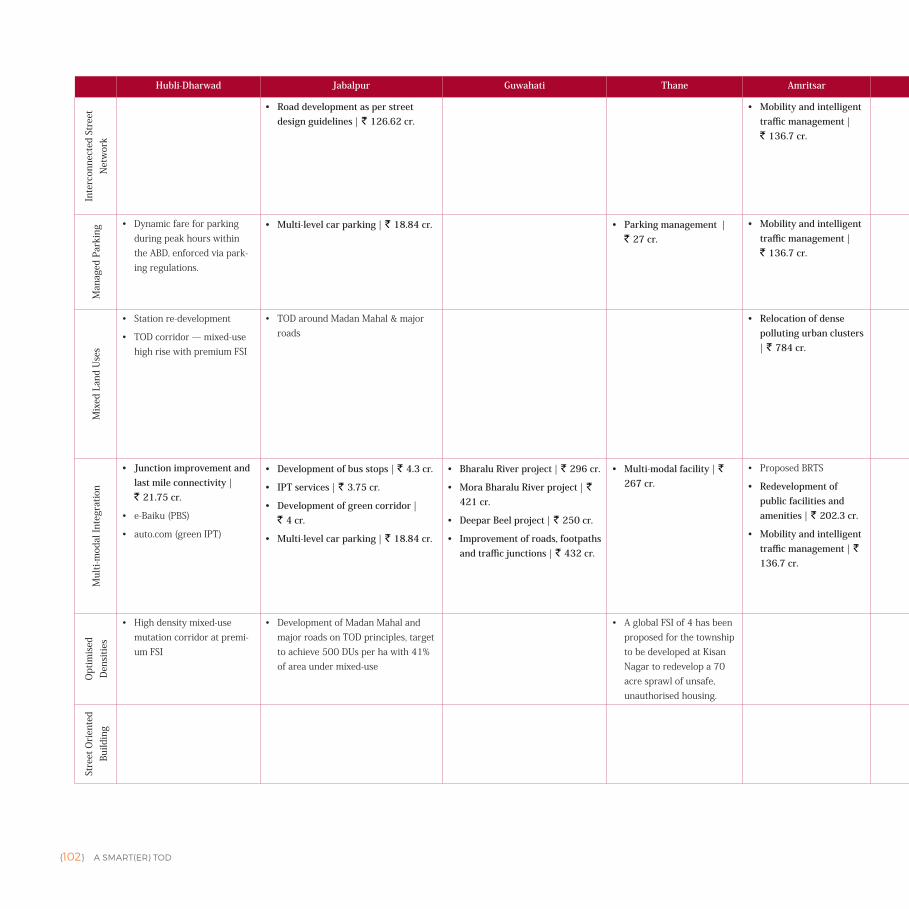
{102} A SMART(ER) TOD
Hubli-Dharwad Jabalpur Guwahati Thane Amritsar Kochi Nagpur Chennai Chandigarh New Town KolkataIn
terc
onne
cted
Str
eet
Net
wor
k• Road development as per street
design guidelines | ` 126.62 cr.• Mobility and intelligent
traffic management | ` 136.7 cr.
• Broadway market and Ernakulam market redevelopment and Mat-tancherry spice market | ` 110 cr.
• Project TenderSURE | ` 220 cr.
• Public market places | ` 2 cr.
• Differently abled foot path | ` 15.84 cr.
• Urban design — public plaza — de-sign for FoW plazas | ` 37.92 cr.
• Sector 43 — urban retrofit develop-ment | ` 4932 cr.
• Footpath | ` 7.2 cr.
• Annual cost of pedestrianisation of Jan Marg on weekends | ` 0.73 cr.
• Pedestrian friendly pathways and non vehicle streets/zones | ` 40.9 cr.
Man
aged
Par
king
• DynamicfareforparkingduringpeakhourswithintheABD,enforcedviapark-ingregulations.
• Multi-level car parking | ` 18.84 cr. • Parking management | ` 27 cr.
• Mobility and intelligent traffic management | ` 136.7 cr.
• MLCP and commercial complex at Kacheripady | ` 50 cr.
• BandararoadTODprecinctinfluencearea—within50mofstationareaonlybikeparking,carsonlyat150to300mofstationarea.Carparkingonlyafter150mfromstation
• Smartparking(multi-levelfor500cars)at3locations
• MLCP with ICT application | ` 120 cr.
• On street parking manage-ment with ICT application | ` 0.30 cr.
• Multilevel car park (300 cars capaci-ty) | ` 16.50 cr.
• Smart Parking | ` 13.50 cr.
Mix
ed L
and
Use
s
• Stationre-development
• TODcorridor—mixed-usehighrisewithpremiumFSI
• TODaroundMadanMahal&majorroads
• Relocation of dense polluting urban clusters | ` 784 cr.
• BandararoadTODprecinctinfluenceareamixed-usecore
• Mixed-useasalandusecategoryinthemasterplan
• Sector 43 — urban retrofit develop-ment | ` 4932 cr.
• 7.2KmlongVikasMargcorridorastransitorienteddevelopment(TOD)
• CentralBusinessDistrictal-lowsupto49%useoflandforresidentialpurpose.Inresidentialareasupto40%ofresidentialspaceforcommercialpurpose.Cityalsofollowsclusterbasedapproachtodevelopmentensuringcompactgrowthofneighborhoods.
Mul
ti-m
odal
Inte
grat
ion
• Junction improvement and last mile connectivity | ` 21.75 cr.
• e-Baiku(PBS)
• auto.com(greenIPT)
• Development of bus stops | ` 4.3 cr.
• IPT services | ` 3.75 cr.
• Development of green corridor | ` 4 cr.
• Multi-level car parking | ` 18.84 cr.
• Bharalu River project | ` 296 cr.
• Mora Bharalu River project | ` 421 cr.
• Deepar Beel project | ` 250 cr.
• Improvement of roads, footpaths and traffic junctions | ` 432 cr.
• Multi-modal facility | ` 267 cr.
• ProposedBRTS
• Redevelopment of public facilities and amenities | ` 202.3 cr.
• Mobility and intelligent traffic management | ` 136.7 cr.
• Electric feeders, bicycle sharing, elevated walk-ways and travelators | ` 11.48 cr.
• MLCP and commercial complex at Kacheripady | ` 50 cr.
• Jetty improvement | ` 8 cr.
• MOVE PEOPLE initiative (e-buses) | ` 37 cr.
• Smart bus shelters | ` 3 cr.
• e-rickshaws | ` 5 cr.
• Project share-a-bike (PPP)
• Automated MLCP at Pardi | ` 15 cr.
• BandararoadTODprecinctinfluencearea—within50mofmetrostationareaonlybicycleparking,carsonlyafter150to300mofmetrostationarea.Integrationwithbustransit
• PANcityfeederbuses&infrastructureundermetroproject
• Cycle sharing system with ICT application | ` 0.15 cr.
• Differently abled foot paths | ` 15.84 cr.
• Electric buses (refurbishment of existing buses) | ` 152 cr.
• Bus stops | ` 12 cr.
• e-rickshaws | ` 1.15 cr.
• Public bike sharing | ` 4.22 cr.
• Footpaths | ` 7.2 cr.
• ToTo, auto Smart Stands | ` 6 cr.
Opt
imis
ed
Den
sitie
s
• Highdensitymixed-usemutationcorridoratpremi-umFSI
• DevelopmentofMadanMahalandmajorroadsonTODprinciples,targettoachieve500DUsperhawith41%ofareaundermixed-use
• AglobalFSIof4hasbeenproposedforthetownshiptobedevelopedatKisanNagartoredevelopa70acresprawlofunsafe,unauthorisedhousing.
• Project TenderSURE | ` 220 cr.
• 10e-toiletsatimportantpubliclocations
• Nocompoundwallsinproposedmixed-usecoreandstationareadevelopmentinABD
• Differently abled foot path bicycle lanes | ` 15.84 cr.
• Sector 43 — urban retrofit develop-ment | ` 4932 cr.
• Refurbishment of existing public toilets | ` 1.8 cr.
• Pedestrian friendly pathways and non vehicle streets/zones | ` 40.9 cr.
Stre
et O
rien
ted
Build
ing
• PremiumFSI—from4to6
• Bandara road TOD precinct influence area mixed-use core
• Transitorientedplanneddevelop-mentmodel(FSI=3.0),buildingheight(Ground+9Storeys)asperdraftTODpolicy
• HigherFARonmetrocorridorforencouragingdevelopment
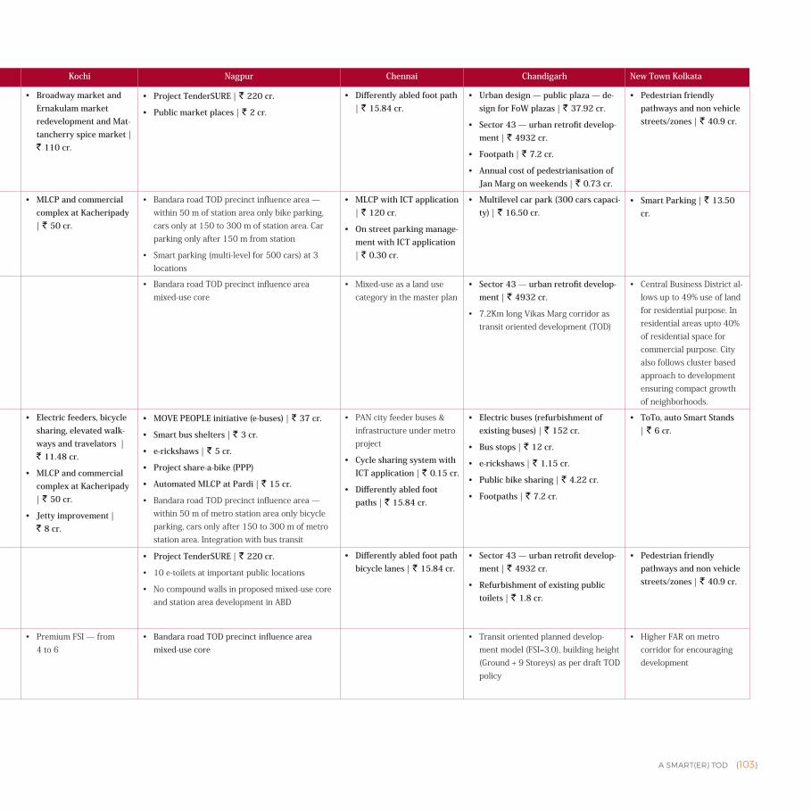
A SMART(ER) TOD {103}
Hubli-Dharwad Jabalpur Guwahati Thane Amritsar Kochi Nagpur Chennai Chandigarh New Town Kolkata
Inte
rcon
nect
ed S
tree
t N
etw
ork
• Road development as per street design guidelines | ` 126.62 cr.
• Mobility and intelligent traffic management | ` 136.7 cr.
• Broadway market and Ernakulam market redevelopment and Mat-tancherry spice market | ` 110 cr.
• Project TenderSURE | ` 220 cr.
• Public market places | ` 2 cr.
• Differently abled foot path | ` 15.84 cr.
• Urban design — public plaza — de-sign for FoW plazas | ` 37.92 cr.
• Sector 43 — urban retrofit develop-ment | ` 4932 cr.
• Footpath | ` 7.2 cr.
• Annual cost of pedestrianisation of Jan Marg on weekends | ` 0.73 cr.
• Pedestrian friendly pathways and non vehicle streets/zones | ` 40.9 cr.
Man
aged
Par
king
• DynamicfareforparkingduringpeakhourswithintheABD,enforcedviapark-ingregulations.
• Multi-level car parking | ` 18.84 cr. • Parking management | ` 27 cr.
• Mobility and intelligent traffic management | ` 136.7 cr.
• MLCP and commercial complex at Kacheripady | ` 50 cr.
• BandararoadTODprecinctinfluencearea—within50mofstationareaonlybikeparking,carsonlyat150to300mofstationarea.Carparkingonlyafter150mfromstation
• Smartparking(multi-levelfor500cars)at3locations
• MLCP with ICT application | ` 120 cr.
• On street parking manage-ment with ICT application | ` 0.30 cr.
• Multilevel car park (300 cars capaci-ty) | ` 16.50 cr.
• Smart Parking | ` 13.50 cr.
Mix
ed L
and
Use
s
• Stationre-development
• TODcorridor—mixed-usehighrisewithpremiumFSI
• TODaroundMadanMahal&majorroads
• Relocation of dense polluting urban clusters | ` 784 cr.
• BandararoadTODprecinctinfluenceareamixed-usecore
• Mixed-useasalandusecategoryinthemasterplan
• Sector 43 — urban retrofit develop-ment | ` 4932 cr.
• 7.2KmlongVikasMargcorridorastransitorienteddevelopment(TOD)
• CentralBusinessDistrictal-lowsupto49%useoflandforresidentialpurpose.Inresidentialareasupto40%ofresidentialspaceforcommercialpurpose.Cityalsofollowsclusterbasedapproachtodevelopmentensuringcompactgrowthofneighborhoods.
Mul
ti-m
odal
Inte
grat
ion
• Junction improvement and last mile connectivity | ` 21.75 cr.
• e-Baiku(PBS)
• auto.com(greenIPT)
• Development of bus stops | ` 4.3 cr.
• IPT services | ` 3.75 cr.
• Development of green corridor | ` 4 cr.
• Multi-level car parking | ` 18.84 cr.
• Bharalu River project | ` 296 cr.
• Mora Bharalu River project | ` 421 cr.
• Deepar Beel project | ` 250 cr.
• Improvement of roads, footpaths and traffic junctions | ` 432 cr.
• Multi-modal facility | ` 267 cr.
• ProposedBRTS
• Redevelopment of public facilities and amenities | ` 202.3 cr.
• Mobility and intelligent traffic management | ` 136.7 cr.
• Electric feeders, bicycle sharing, elevated walk-ways and travelators | ` 11.48 cr.
• MLCP and commercial complex at Kacheripady | ` 50 cr.
• Jetty improvement | ` 8 cr.
• MOVE PEOPLE initiative (e-buses) | ` 37 cr.
• Smart bus shelters | ` 3 cr.
• e-rickshaws | ` 5 cr.
• Project share-a-bike (PPP)
• Automated MLCP at Pardi | ` 15 cr.
• BandararoadTODprecinctinfluencearea—within50mofmetrostationareaonlybicycleparking,carsonlyafter150to300mofmetrostationarea.Integrationwithbustransit
• PANcityfeederbuses&infrastructureundermetroproject
• Cycle sharing system with ICT application | ` 0.15 cr.
• Differently abled foot paths | ` 15.84 cr.
• Electric buses (refurbishment of existing buses) | ` 152 cr.
• Bus stops | ` 12 cr.
• e-rickshaws | ` 1.15 cr.
• Public bike sharing | ` 4.22 cr.
• Footpaths | ` 7.2 cr.
• ToTo, auto Smart Stands | ` 6 cr.
Opt
imis
ed
Den
sitie
s
• Highdensitymixed-usemutationcorridoratpremi-umFSI
• DevelopmentofMadanMahalandmajorroadsonTODprinciples,targettoachieve500DUsperhawith41%ofareaundermixed-use
• AglobalFSIof4hasbeenproposedforthetownshiptobedevelopedatKisanNagartoredevelopa70acresprawlofunsafe,unauthorisedhousing.
• Project TenderSURE | ` 220 cr.
• 10e-toiletsatimportantpubliclocations
• Nocompoundwallsinproposedmixed-usecoreandstationareadevelopmentinABD
• Differently abled foot path bicycle lanes | ` 15.84 cr.
• Sector 43 — urban retrofit develop-ment | ` 4932 cr.
• Refurbishment of existing public toilets | ` 1.8 cr.
• Pedestrian friendly pathways and non vehicle streets/zones | ` 40.9 cr.
Stre
et O
rien
ted
Build
ing
• PremiumFSI—from4to6
• Bandara road TOD precinct influence area mixed-use core
• Transitorientedplanneddevelop-mentmodel(FSI=3.0),buildingheight(Ground+9Storeys)asperdraftTODpolicy
• HigherFARonmetrocorridorforencouragingdevelopment
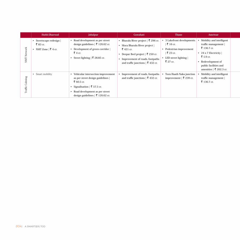
{104} A SMART(ER) TOD
Hubli-Dharwad Jabalpur Guwahati Thane Amritsar Kochi Nagpur Chennai Chandigarh New Town Kolkata
NM
T N
etw
ork
• Streetscape redesign | ` 83 cr.
• NMT Zone | ` 4 cr.
• Road development as per street design guidelines | ` 126.62 cr.
• Development of green corridor | ` 4 cr.
• Street lighting | ` 28.85 cr.
• Bharalu River project | ` 296 cr.
• Mora Bharalu River project | ` 421 cr.
• Deepar Beel project | ` 250 cr.
• Improvement of roads, footpaths and traffic junctions | ` 432 cr.
• 3 Lakefront developments | ` 16 cr.
• Pedestrian improvement | ` 23 cr.
• LED street lighting | ` 27 cr.
• Mobility and intelligent traffic management | ` 136.7 cr.
• 24 x 7 Electricity | ` 5.9 cr.
• Redevelopment of public facilities and amenities | ` 202.3 cr.
• Bandara road TOD precinct influence area mixed-use core
• Ground floor as commer-cial as per master plan
• Urban design — public plaza — de-sign for FoW plazas | ` 37.92 cr.
• Sector 43 — Urban retrofit develop-ment | ` 4932 cr.
Traffi
c Ca
lmin
g
• Smartmobility • Vehicular intersection improvement as per street design guidelines | ` 60.5 cr.
• Signalisation | ` 57.5 cr.
• Road development as per street design guidelines | ` 126.62 cr.
• Improvement of roads, footpaths and traffic junctions | ` 432 cr.
• Teen Haath Naka junction improvement | ` 239 cr.
• Mobility and intelligent traffic management | ` 136.7 cr.
• Project TenderSURE (Road and NMT) • Traffic calming streets • Signalisation at intersections (vehi-cle activated ATCS compatible traffic signals) | ` 4.6 cr.
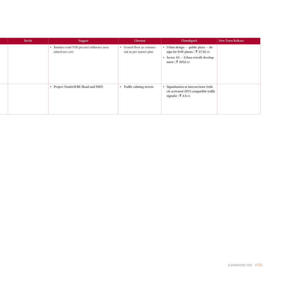
A SMART(ER) TOD {105}
Hubli-Dharwad Jabalpur Guwahati Thane Amritsar Kochi Nagpur Chennai Chandigarh New Town Kolkata
NM
T N
etw
ork
• Streetscape redesign | ` 83 cr.
• NMT Zone | ` 4 cr.
• Road development as per street design guidelines | ` 126.62 cr.
• Development of green corridor | ` 4 cr.
• Street lighting | ` 28.85 cr.
• Bharalu River project | ` 296 cr.
• Mora Bharalu River project | ` 421 cr.
• Deepar Beel project | ` 250 cr.
• Improvement of roads, footpaths and traffic junctions | ` 432 cr.
• 3 Lakefront developments | ` 16 cr.
• Pedestrian improvement | ` 23 cr.
• LED street lighting | ` 27 cr.
• Mobility and intelligent traffic management | ` 136.7 cr.
• 24 x 7 Electricity | ` 5.9 cr.
• Redevelopment of public facilities and amenities | ` 202.3 cr.
• Bandara road TOD precinct influence area mixed-use core
• Ground floor as commer-cial as per master plan
• Urban design — public plaza — de-sign for FoW plazas | ` 37.92 cr.
• Sector 43 — Urban retrofit develop-ment | ` 4932 cr.
Traffi
c Ca
lmin
g
• Smartmobility • Vehicular intersection improvement as per street design guidelines | ` 60.5 cr.
• Signalisation | ` 57.5 cr.
• Road development as per street design guidelines | ` 126.62 cr.
• Improvement of roads, footpaths and traffic junctions | ` 432 cr.
• Teen Haath Naka junction improvement | ` 239 cr.
• Mobility and intelligent traffic management | ` 136.7 cr.
• Project TenderSURE (Road and NMT) • Traffic calming streets • Signalisation at intersections (vehi-cle activated ATCS compatible traffic signals) | ` 4.6 cr.
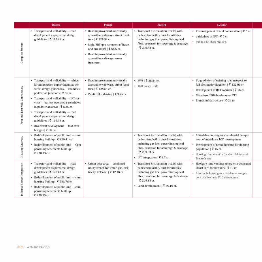
{106} A SMART(ER) TOD
Indore Panaji Ranchi Gwalior Bhopal Ajmer Bhubaneswar Ujjain Faridabad Agra AhmedabadCo
mpl
ete
Stre
ets
• Transport and walkability — road development as per street design guidelines | ` 129.41 cr.
• Road improvement, universally accessible walkways, street furni-ture | ` 128.54 cr.
• Light BRT (procurement of buses and bus stops) | ` 65.6 cr.
• Road improvement, universally accessible walkways, street furniture
• Transport & circulation (roads) with pedestrian facility duct for utilities including gas line, power line, optical fibre, provision for sewerage & drainage | ` 209.83 cr.
• Redevelopment of Amkho bus stand | ` 5 cr.
• e-rickshaw as IPT | ` 5 cr.
• Publicbikesharestations
• Mobility | ` 95 cr.
• Road up-gradation and multi-level fly-over | ` 25.51 cr.
• NMT — footpath and cycle tracks | ` 25.51 cr.
• Smart centralised bus stand | ` 50 cr.
• Vending zones | ` 215 cr.
• Public bicycle sharing scheme | ` 9.5 cr.
• Project URBS — urban regen-eration through Bhubaneswar streets | ` 71.5 cr.
• Janpath people's smart path | ` 72.5 cr.
• Partivartan Path | ` 42 cr.
• Multi-modal transit hub | ` 92.05 cr.
• Footpath development | ` 22.4 cr.
• Segregated cycle track | ` 34.92 cr.
• Redevelopment of water body | ` 0.11 cr.
• Parks and open air gym | ` 6.54 cr.
• Enhancing experience of accessing — foot-paths | ` 197.27 cr.
• Agra-Etawah Lion Safari cycle highway | ` 4.20 cr.
• Street designing | ` 168 cr.
• Street vending zone | ` 8 cr.
• Retrofitting of utility network | ` 385 cr.
• NMT tracks/cycle tracks | ` 2 cr.
• Smart traffic — integrated transit manage-ment platform | ` 194 cr.
Firs
t and
Las
t Mile
Con
nect
ivity
• Transport and walkability — vehicu-lar intersection improvement as per street design guidelines — mid block pedestrian junctions | ` 56 cr.
• Transport and walkability — IPT ser-vices — battery operated e-rickshaws in pedestrian areas | ` 6.25 cr.
• Transport and walkability — road development as per street design guidelines | ` 129.41 cr.
• Riverfront development — foot over bridges | ` 96 cr.
• Road improvement, universally accessible walkways, street furni-ture | ` 128.54 cr.
• Public bike sharing | ` 9.75 cr.
• EWS | ` 38.84 cr.
• TODPolicyDraft
• Up-gradation of existing road network to full section development | ` 132.09 cr.
• Development of BRT corridor | ` 16 cr.
• Mixed-use TOD development PPP
• Transit infrastructure | ` 24 cr.
• Mobility | ` 95 cr.
• NMT — footpath and cycle tracks | ` 25.51 cr.
• Janpath people's smart path | ` 72.5 cr.
• BBSR cycle highway | ` 16 cr.
• Project URBS — urban regen-eration through Bhubaneswar streets | ` 71.5 cr.
• e-rickshaw project | ` 10.5 cr.
• Aradhana Path | ` 126.74 cr.
• Parivartan Path | ` 42 cr.
• Dharohar Path | ` 34.1 cr.
• Mobility | ` 125.99 cr.
• Segregated cycle track | ` 34.92 cr.
• Auto rickshaw parking area | ` 0.97 cr.
• e-rickshaw stands | ` 5 cr.
• Cycle parking area | ` 0.49 cr.
• Footpath development | ` 22.4 cr.
• Agra-Etawah Lion Safari Cycle highway | ` 4.20 cr.
• Street designing | ` 168 cr.
• Bicycle sharing | ` 1 cr.
• Enhancing experience of accessing — foot-paths | ` 197.27 cr.
• NMT tracks/cycle tracks | ` 2 cr.
Hou
sing
Div
ersi
ty
• Redevelopment of public land — slum housing built up | ` 129.41 cr.
• Redevelopment of public land — Com-pensatory tenements built-up | ` 270.33 cr.
• Transport & circulation (roads) with pedestrian facility duct for utilities including gas line, power line, optical fibre, provision for sewerage & drainage | ` 209.83 cr.
• IPT integration | ` 2.7 cr.
• Affordable housing as a residential compo-nent of mixed-use TOD development
• Development of rental housing for floating population | ` 45 cr.
• HousingcomponentinGwaliorHabitatandTradeCentre
• Housing | ` 914 cr.
• Street vending zone | ` 8 cr.
• Redevelopment of Wadaj slum | ` 604 cr.
Info
rmal
Sec
tor
Inte
grat
ion • Transport and walkability — road
development as per street design guidelines | ` 129.41 cr.
• Redevelopment of public land — slum housing built up | ` 232.76 cr.
• Redevelopment of public land — com-pensatory tenements built up | ` 270.33 cr.
• Urban poor area — combined utility trench for water, gas, elec-tricity, Telecom | ` 12.16 cr.
• Transport & circulation (roads) with pedestrian facility duct for utilities including gas line, power line, optical fibre, provision for sewerage & drainage | ` 209.83 cr.
• Land development | ` 60.19 cr.
• Hawker's and vending zones with dedicated smart card for hawkers | ` 10 cr.
• Affordablehousingasaresidentialcompo-nentofmixed-useTODdevelopment
• Area improvement | ` 20 cr.
• Road up-gradation and multi-level fly-over | ` 25.51 cr.
• Vending zones | ` 215 cr.
• e-rickshaw project | ` 10.5 cr.
• Mission Abaas | ` 840 cr.
• Janpath people's smart path | ` 72.5 cr.
• Ashray | ` 478.84 cr.
• Multi-modal transit hub | ` 92.05 cr.
• Parks and open air gym | ` 6.54 cr.
• e-rickshaw stands | ` 5 cr.
• Auto rickshaw parking Area | ` 0.97 cr.
• Redevelopment of water body | ` 0.11 cr.
• Redevelopment of Wadaj slum | ` 604 cr.
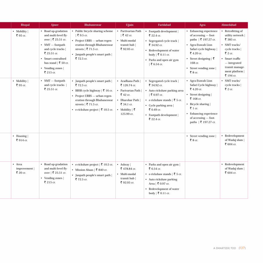
A SMART(ER) TOD {107}
Indore Panaji Ranchi Gwalior Bhopal Ajmer Bhubaneswar Ujjain Faridabad Agra Ahmedabad
Com
plet
e St
reet
s
• Transport and walkability — road development as per street design guidelines | ` 129.41 cr.
• Road improvement, universally accessible walkways, street furni-ture | ` 128.54 cr.
• Light BRT (procurement of buses and bus stops) | ` 65.6 cr.
• Road improvement, universally accessible walkways, street furniture
• Transport & circulation (roads) with pedestrian facility duct for utilities including gas line, power line, optical fibre, provision for sewerage & drainage | ` 209.83 cr.
• Redevelopment of Amkho bus stand | ` 5 cr.
• e-rickshaw as IPT | ` 5 cr.
• Publicbikesharestations
• Mobility | ` 95 cr.
• Road up-gradation and multi-level fly-over | ` 25.51 cr.
• NMT — footpath and cycle tracks | ` 25.51 cr.
• Smart centralised bus stand | ` 50 cr.
• Vending zones | ` 215 cr.
• Public bicycle sharing scheme | ` 9.5 cr.
• Project URBS — urban regen-eration through Bhubaneswar streets | ` 71.5 cr.
• Janpath people's smart path | ` 72.5 cr.
• Partivartan Path | ` 42 cr.
• Multi-modal transit hub | ` 92.05 cr.
• Footpath development | ` 22.4 cr.
• Segregated cycle track | ` 34.92 cr.
• Redevelopment of water body | ` 0.11 cr.
• Parks and open air gym | ` 6.54 cr.
• Enhancing experience of accessing — foot-paths | ` 197.27 cr.
• Agra-Etawah Lion Safari cycle highway | ` 4.20 cr.
• Street designing | ` 168 cr.
• Street vending zone | ` 8 cr.
• Retrofitting of utility network | ` 385 cr.
• NMT tracks/cycle tracks | ` 2 cr.
• Smart traffic — integrated transit manage-ment platform | ` 194 cr.
Firs
t and
Las
t Mile
Con
nect
ivity
• Transport and walkability — vehicu-lar intersection improvement as per street design guidelines — mid block pedestrian junctions | ` 56 cr.
• Transport and walkability — IPT ser-vices — battery operated e-rickshaws in pedestrian areas | ` 6.25 cr.
• Transport and walkability — road development as per street design guidelines | ` 129.41 cr.
• Riverfront development — foot over bridges | ` 96 cr.
• Road improvement, universally accessible walkways, street furni-ture | ` 128.54 cr.
• Public bike sharing | ` 9.75 cr.
• EWS | ` 38.84 cr.
• TODPolicyDraft
• Up-gradation of existing road network to full section development | ` 132.09 cr.
• Development of BRT corridor | ` 16 cr.
• Mixed-use TOD development PPP
• Transit infrastructure | ` 24 cr.
• Mobility | ` 95 cr.
• NMT — footpath and cycle tracks | ` 25.51 cr.
• Janpath people's smart path | ` 72.5 cr.
• BBSR cycle highway | ` 16 cr.
• Project URBS — urban regen-eration through Bhubaneswar streets | ` 71.5 cr.
• e-rickshaw project | ` 10.5 cr.
• Aradhana Path | ` 126.74 cr.
• Parivartan Path | ` 42 cr.
• Dharohar Path | ` 34.1 cr.
• Mobility | ` 125.99 cr.
• Segregated cycle track | ` 34.92 cr.
• Auto rickshaw parking area | ` 0.97 cr.
• e-rickshaw stands | ` 5 cr.
• Cycle parking area | ` 0.49 cr.
• Footpath development | ` 22.4 cr.
• Agra-Etawah Lion Safari Cycle highway | ` 4.20 cr.
• Street designing | ` 168 cr.
• Bicycle sharing | ` 1 cr.
• Enhancing experience of accessing — foot-paths | ` 197.27 cr.
• NMT tracks/cycle tracks | ` 2 cr.
Hou
sing
Div
ersi
ty
• Redevelopment of public land — slum housing built up | ` 129.41 cr.
• Redevelopment of public land — Com-pensatory tenements built-up | ` 270.33 cr.
• Transport & circulation (roads) with pedestrian facility duct for utilities including gas line, power line, optical fibre, provision for sewerage & drainage | ` 209.83 cr.
• IPT integration | ` 2.7 cr.
• Affordable housing as a residential compo-nent of mixed-use TOD development
• Development of rental housing for floating population | ` 45 cr.
• HousingcomponentinGwaliorHabitatandTradeCentre
• Housing | ` 914 cr.
• Street vending zone | ` 8 cr.
• Redevelopment of Wadaj slum | ` 604 cr.
Info
rmal
Sec
tor
Inte
grat
ion • Transport and walkability — road
development as per street design guidelines | ` 129.41 cr.
• Redevelopment of public land — slum housing built up | ` 232.76 cr.
• Redevelopment of public land — com-pensatory tenements built up | ` 270.33 cr.
• Urban poor area — combined utility trench for water, gas, elec-tricity, Telecom | ` 12.16 cr.
• Transport & circulation (roads) with pedestrian facility duct for utilities including gas line, power line, optical fibre, provision for sewerage & drainage | ` 209.83 cr.
• Land development | ` 60.19 cr.
• Hawker's and vending zones with dedicated smart card for hawkers | ` 10 cr.
• Affordablehousingasaresidentialcompo-nentofmixed-useTODdevelopment
• Area improvement | ` 20 cr.
• Road up-gradation and multi-level fly-over | ` 25.51 cr.
• Vending zones | ` 215 cr.
• e-rickshaw project | ` 10.5 cr.
• Mission Abaas | ` 840 cr.
• Janpath people's smart path | ` 72.5 cr.
• Ashray | ` 478.84 cr.
• Multi-modal transit hub | ` 92.05 cr.
• Parks and open air gym | ` 6.54 cr.
• e-rickshaw stands | ` 5 cr.
• Auto rickshaw parking Area | ` 0.97 cr.
• Redevelopment of water body | ` 0.11 cr.
• Redevelopment of Wadaj slum | ` 604 cr.
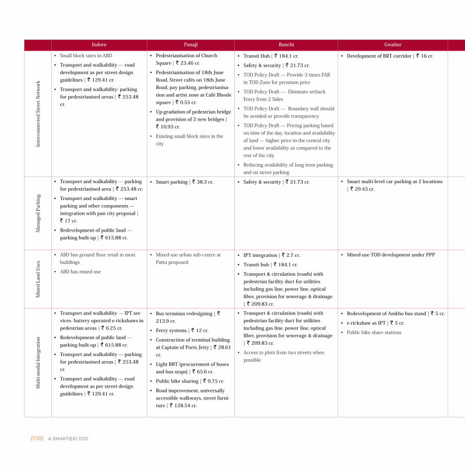
{108} A SMART(ER) TOD
Indore Panaji Ranchi Gwalior Bhopal Ajmer Bhubaneswar Ujjain Faridabad Agra AhmedabadIn
terc
onne
cted
Str
eet N
etw
ork
• SmallblocksizesinABD
• Transport and walkability — road development as per street design guidelines | ` 129.41 cr.
• Transport and walkability- parking for pedestrianised areas | ` 253.48 cr.
• Pedestrianisation of Church Square | ` 23.46 cr.
• Pedestrianisation of 18th June Road, Street cafés on 18th June Road, pay parking, pedestrianisa-tion and artist zone at Café Bhosle square | ` 0.55 cr.
• Up-gradation of pedestrian bridge and provision of 2 new bridges | ` 10.93 cr.
• Existingsmallblocksizesinthecity
• Transit Hub | ` 184.1 cr.
• Safety & security | ` 21.73 cr.
• TODPolicyDraft—Provide3timesFARinTODZoneforpremiumprice
• TODPolicyDraft—EliminatesetbackEntryfrom2Sides
• TODPolicyDraft—Boundarywallshouldbeavoidedorprovidetransparency
• TODPolicyDraft—Pricingparkingbasedontimeoftheday,locationandavailabilityofland—higherpriceinthecentralcityandloweravailabilityascomparedtotherestofthecity
• Reducingavailabilityoflongtermparkingandonstreetparking
• Development of BRT corridor | ` 16 cr. • Area improvement | ` 20 cr.
• Project URBS — urban regen-eration through Bhubaneswar streets | ` 71.5 cr.
• Parivartan Path | ` 42 cr.
• Dharohar Path | ` 34.1 cr.
• Mobility | ` 125.99 cr.
Man
aged
Par
king
• Transport and walkability — parking for pedestrianised area | ` 253.48 cr.
• Transport and walkability — smart parking and other components — integration with pan city proposal | ` 17 cr.
• Redevelopment of public land — parking built-up | ` 615.88 cr.
• Smart parking | ` 38.3 cr. • Safety & security | ` 21.73 cr. • Smart multi-level car parking at 2 locations | ` 29.43 cr.
• Mobility | ` 95 cr.
• Parkinginthebasementofdevelopment,availableatpre-miumpricing
• Multi-levelcarparking
• Road up-gradation and multi-level flyover | ` 215 cr.
• Smart parking | ` 115 cr.
• Railway station multi-modal hub | ` 845 cr.
• Multi-modal transit hub | ` 92.05 cr.
• Multiple level parking (railway station and Badkal more metro station) | ` 27.5 cr.
• Façade improvement in TajGanj along herit-age walk; cleaning of Taj corridor | ` 15.75 cr.
Mix
ed L
and
Use
s
• ABDhasgroundfloorretailinmostbuildings
• ABDhasmixed-use
• Mixed-useurbansub-centreatPattoproposed
• IPT integration | ` 2.7 cr.
• Transit hub | ` 184.1 cr.
• Transport & circulation (roads) with pedestrian facility duct for utilities including gas line, power line, optical fibre, provision for sewerage & drainage | ` 209.83 cr.
• Mixed-use TOD development under PPP • Artha Kshetra | ` 45.43 cr.
• TODcompliantdevelopmentofretail,hotelsandcommer-cialproposed
• Mixed-use development — built area along the transit corridor | ` 155.66 cr.
• Bicycle sharing | ` 1 cr.
Mul
ti-m
odal
Inte
grat
ion
• Transport and walkability — IPT ser-vices- battery operated e-rickshaws in pedestrian areas | ` 6.25 cr.
• Redevelopment of public land — parking built-up | ` 615.88 cr.
• Transport and walkability — parking for pedestrianised areas | ` 253.48 cr.
• Transport and walkability — road development as per street design guidelines | ` 129.41 cr.
• Bus terminus redesigning | ` 213.9 cr.
• Ferry systems | ` 12 cr.
• Construction of terminal building at Captain of Ports Jetty | ` 28.61 cr.
• Light BRT (procurement of buses and bus stops) | ` 65.6 cr.
• Public bike sharing | ` 9.75 cr.
• Road improvement, universally accessible walkways, street furni-ture | ` 128.54 cr.
• Transport & circulation (roads) with pedestrian facility duct for utilities including gas line, power line, optical fibre, provision for sewerage & drainage | ` 209.83 cr.
• Accesstoplotsfromtwostreetswhenpossible
• Redevelopment of Amkho bus stand | ` 5 cr.
• e-rickshaw as IPT | ` 5 cr.
• Publicbikesharestations
• Mobility | ` 95 cr.
• Road up-gradation and multi-level flyover | ` 215 cr.
• Smart parking | ` 115 cr.
• Multi-modalhubrailwaystation
• Project URBS — urban regen-eration through Bhubaneswar streets | ` 71.5 cr.
• Railway station multi-modal hub | ` 845 cr.
• Multi-modal transit hub | ` 92.05 cr.
• Cycle parking area | ` 0.49 cr.
• Footpath development | ` 22.4 cr.
• Multi-modalhubatrailwaystation
• Multiple level parking (railway station and Badkal more metro station) | ` 27.5 cr.
• Auto rickshaw parking area | ` 0.97 cr.
• e-rickshaw stand | ` 5 cr.
• Beautification and streetscaping of Fate-habad Road | ` 3.90 cr.
• Conversion of street lights to LED | ` 7.05 cr.
• Roadside plantation | ` 2 cr.
• Development of intermodal hub | ` 125 cr.
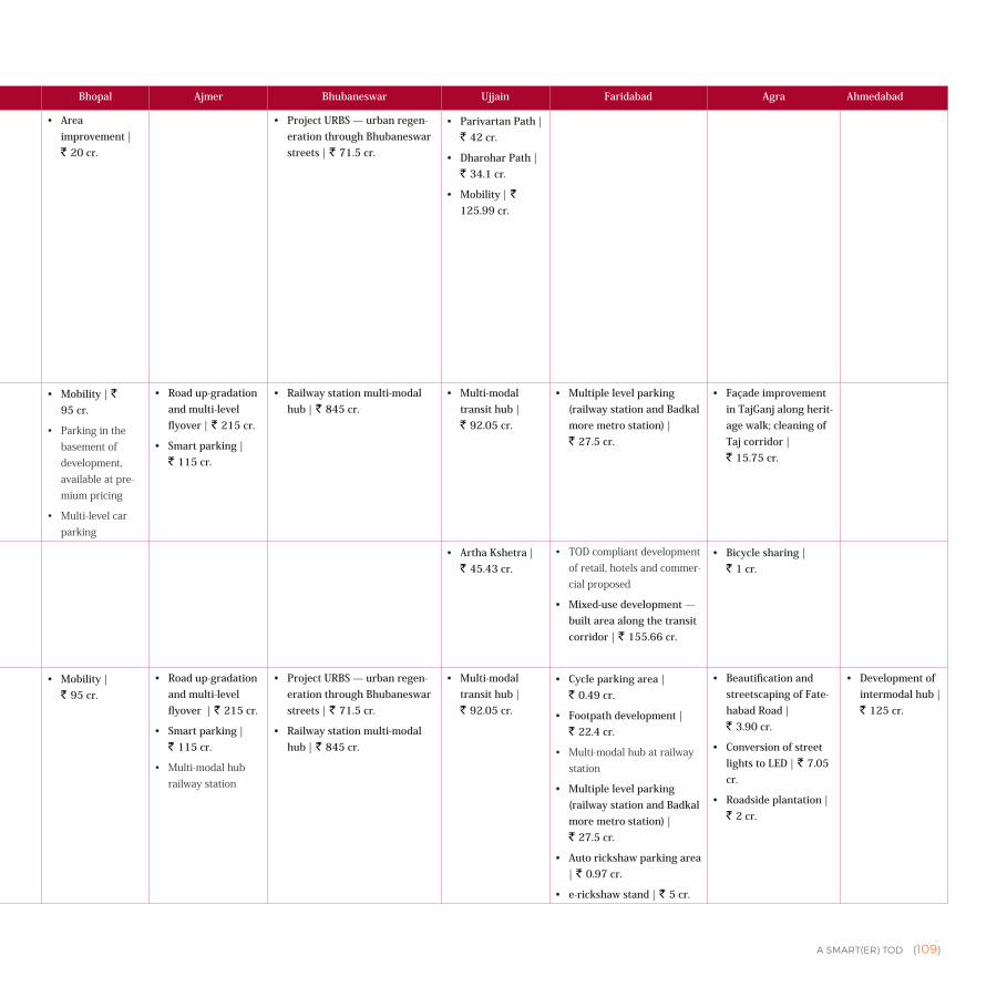
A SMART(ER) TOD {109}
Indore Panaji Ranchi Gwalior Bhopal Ajmer Bhubaneswar Ujjain Faridabad Agra Ahmedabad
Inte
rcon
nect
ed S
tree
t Net
wor
k
• SmallblocksizesinABD
• Transport and walkability — road development as per street design guidelines | ` 129.41 cr.
• Transport and walkability- parking for pedestrianised areas | ` 253.48 cr.
• Pedestrianisation of Church Square | ` 23.46 cr.
• Pedestrianisation of 18th June Road, Street cafés on 18th June Road, pay parking, pedestrianisa-tion and artist zone at Café Bhosle square | ` 0.55 cr.
• Up-gradation of pedestrian bridge and provision of 2 new bridges | ` 10.93 cr.
• Existingsmallblocksizesinthecity
• Transit Hub | ` 184.1 cr.
• Safety & security | ` 21.73 cr.
• TODPolicyDraft—Provide3timesFARinTODZoneforpremiumprice
• TODPolicyDraft—EliminatesetbackEntryfrom2Sides
• TODPolicyDraft—Boundarywallshouldbeavoidedorprovidetransparency
• TODPolicyDraft—Pricingparkingbasedontimeoftheday,locationandavailabilityofland—higherpriceinthecentralcityandloweravailabilityascomparedtotherestofthecity
• Reducingavailabilityoflongtermparkingandonstreetparking
• Development of BRT corridor | ` 16 cr. • Area improvement | ` 20 cr.
• Project URBS — urban regen-eration through Bhubaneswar streets | ` 71.5 cr.
• Parivartan Path | ` 42 cr.
• Dharohar Path | ` 34.1 cr.
• Mobility | ` 125.99 cr.
Man
aged
Par
king
• Transport and walkability — parking for pedestrianised area | ` 253.48 cr.
• Transport and walkability — smart parking and other components — integration with pan city proposal | ` 17 cr.
• Redevelopment of public land — parking built-up | ` 615.88 cr.
• Smart parking | ` 38.3 cr. • Safety & security | ` 21.73 cr. • Smart multi-level car parking at 2 locations | ` 29.43 cr.
• Mobility | ` 95 cr.
• Parkinginthebasementofdevelopment,availableatpre-miumpricing
• Multi-levelcarparking
• Road up-gradation and multi-level flyover | ` 215 cr.
• Smart parking | ` 115 cr.
• Railway station multi-modal hub | ` 845 cr.
• Multi-modal transit hub | ` 92.05 cr.
• Multiple level parking (railway station and Badkal more metro station) | ` 27.5 cr.
• Façade improvement in TajGanj along herit-age walk; cleaning of Taj corridor | ` 15.75 cr.
Mix
ed L
and
Use
s
• ABDhasgroundfloorretailinmostbuildings
• ABDhasmixed-use
• Mixed-useurbansub-centreatPattoproposed
• IPT integration | ` 2.7 cr.
• Transit hub | ` 184.1 cr.
• Transport & circulation (roads) with pedestrian facility duct for utilities including gas line, power line, optical fibre, provision for sewerage & drainage | ` 209.83 cr.
• Mixed-use TOD development under PPP • Artha Kshetra | ` 45.43 cr.
• TODcompliantdevelopmentofretail,hotelsandcommer-cialproposed
• Mixed-use development — built area along the transit corridor | ` 155.66 cr.
• Bicycle sharing | ` 1 cr.
Mul
ti-m
odal
Inte
grat
ion
• Transport and walkability — IPT ser-vices- battery operated e-rickshaws in pedestrian areas | ` 6.25 cr.
• Redevelopment of public land — parking built-up | ` 615.88 cr.
• Transport and walkability — parking for pedestrianised areas | ` 253.48 cr.
• Transport and walkability — road development as per street design guidelines | ` 129.41 cr.
• Bus terminus redesigning | ` 213.9 cr.
• Ferry systems | ` 12 cr.
• Construction of terminal building at Captain of Ports Jetty | ` 28.61 cr.
• Light BRT (procurement of buses and bus stops) | ` 65.6 cr.
• Public bike sharing | ` 9.75 cr.
• Road improvement, universally accessible walkways, street furni-ture | ` 128.54 cr.
• Transport & circulation (roads) with pedestrian facility duct for utilities including gas line, power line, optical fibre, provision for sewerage & drainage | ` 209.83 cr.
• Accesstoplotsfromtwostreetswhenpossible
• Redevelopment of Amkho bus stand | ` 5 cr.
• e-rickshaw as IPT | ` 5 cr.
• Publicbikesharestations
• Mobility | ` 95 cr.
• Road up-gradation and multi-level flyover | ` 215 cr.
• Smart parking | ` 115 cr.
• Multi-modalhubrailwaystation
• Project URBS — urban regen-eration through Bhubaneswar streets | ` 71.5 cr.
• Railway station multi-modal hub | ` 845 cr.
• Multi-modal transit hub | ` 92.05 cr.
• Cycle parking area | ` 0.49 cr.
• Footpath development | ` 22.4 cr.
• Multi-modalhubatrailwaystation
• Multiple level parking (railway station and Badkal more metro station) | ` 27.5 cr.
• Auto rickshaw parking area | ` 0.97 cr.
• e-rickshaw stand | ` 5 cr.
• Beautification and streetscaping of Fate-habad Road | ` 3.90 cr.
• Conversion of street lights to LED | ` 7.05 cr.
• Roadside plantation | ` 2 cr.
• Development of intermodal hub | ` 125 cr.
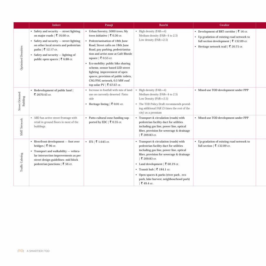
{110} A SMART(ER) TOD
Indore Panaji Ranchi Gwalior Bhopal Ajmer Bhubaneswar Ujjain Faridabad Agra AhmedabadO
ptim
ised
Den
sitie
s
• Safety and security — street lighting on major roads | ` 16.60 cr.
• Safety and security — street lighting on other local streets and pedestrian paths | ` 12.17 cr.
• Safety and security — lighting of public open spaces | ` 6.88 cr.
• Urban forestry, 5000 trees, My trees initiative | ` 0.36 cr.
• Pedestrianisation of 18th June Road, Street cafés on 18th June Road, pay parking, pedestrianisa-tion and artist zone at Café Bhosle square | ` 0.55 cr.
• Eco-mobility: public bike sharing scheme, sensor based LED street lighting improvement of open spaces, provision of public toilets, CNG/PNG network, 0.5 MW roof top solar PV | ` 67.67 cr.
• Highdensity(FAR>=4)Mediumdensity(FAR=4to2.5)Lowdensity(FAR<=2.5)
• Development of BRT corridor | ` 16 cr.
• Up-gradation of existing road network to full section development | ` 132.09 cr.
• Heritage network trail | ` 20.75 cr.
• Area improve-ment | ` 20 cr.
• NMT — footpath and cycle tracks road up-gradation and multi-level fly-over | ` 25.51 cr.
• Janpath people's smart path | ` 72.5 cr.
• Project URBS — urban regen-eration through Bhubaneswar streets | ` 71.5 cr.
• Parivartan Path | ` 42 cr.
• Mobility | ` 125.99 cr.
• Footpath development | ` 22.4 cr.
• Solar LED street lighting | ` 10.68 cr.
• Smart toilets | ` 3.75 cr.
• Community smart toilets | ` 0.05 cr.
• Retrofitting of utility network | ` 385 cr.
Stre
et O
rien
ted
Build
ing
• Redevelopment of public land | ` 2670.45 cr.
• IncreaseinfootfallwithmixoflanduseoncurrentlydesertedPattoside
• Heritage listing | ` 0.01 cr.
• Highdensity(FAR>=4)Mediumdensity(FAR=4to2.5)LowDensity(FAR<=2.5)
• TheTODPolicyDraftrecommendsprovid-ingadditionalFAR(3timestherestofthecity)asapremium
• Mixed-use TOD development under PPP • Anasagar prome-nade | ` 110.69 cr.
• 600PPHproposeddensity • Parivartan Path | ` 42 cr.
• Artha Kshetra | ` 45.43 cr.
• IncreaseddensityandcompactdevelopmentwithconsistentdevelopmentcontroltobeincorporatedintheTODguideline
• Façade improvement in TajGanj along herit-age walk; cleaning of Taj corridor | ` 15.75 cr.
• Redevelopment of Wadaj slum | ` 604 cr.
• Wadaj TOZ | ` 510 cr.
NM
T N
etw
ork • ABDhasactivestreetfrontagewith
retailingroundfloorsinmostofthebuildings
• Patto cultural zone funding sup-ported by EDC | ` 0.35 cr.
• Transport & circulation (roads) with pedestrian facility duct for utilities including gas line, power line, optical fibre, provision for sewerage & drainage | ` 209.83 cr.
• Mixed-use TOD development under PPP • Activitygenerat-ingusestokeepstreetssafe
• Road up-gradation and multi-level flyover | ` 215 cr.
• Janpath people's smart path | ` 72.5 cr.
• Project URBS - urban regener-ation through Bhubaneswar streets | ` 71.5 cr.
• Parivartan Path | ` 42 cr.
• Variable message signboards, pelican signals, corridor im-provement | ` 6.73 cr.
Traffi
c Ca
lmin
g
• Riverfront development — foot over bridges | ` 96 cr.
• Transport and walkability — vehicu-lar intersection improvements as per street design guidelines- mid block pedestrian junctions | ` 56 cr.
• ITS | ` 1.645 cr. • Transport & circulation (roads) with pedestrian facility duct for utilities including gas line, power line, optical fibre, provision for sewerage & drainage | ` 209.83 cr.
• Land development | ` 60.19 cr.
• Transit hub | ` 184.1 cr.
• Open spaces & parks (river park , eco park, lake harvest, neighbourhood park) | ` 49.4 cr.
• Up-gradation of existing road network to full section | ` 132.09 cr.
• Area improve-ment | ` 20 cr.
• Road up-gradation and multi-level flyover | ` 215 cr.
• Project URBS - urban regener-ation through Bhubaneswar streets | ` 71.5 cr.
• Janpath people's smart path | ` 72.5 cr.
• Road improvement - main access roads | ` 1.9 cr.
• Internal roads improve-ment and landscaping | ` 69.31 cr.
• FOB joining railway station to metro station | ` 8.78 cr.
• Segregated cycle track | ` 34.92 cr.
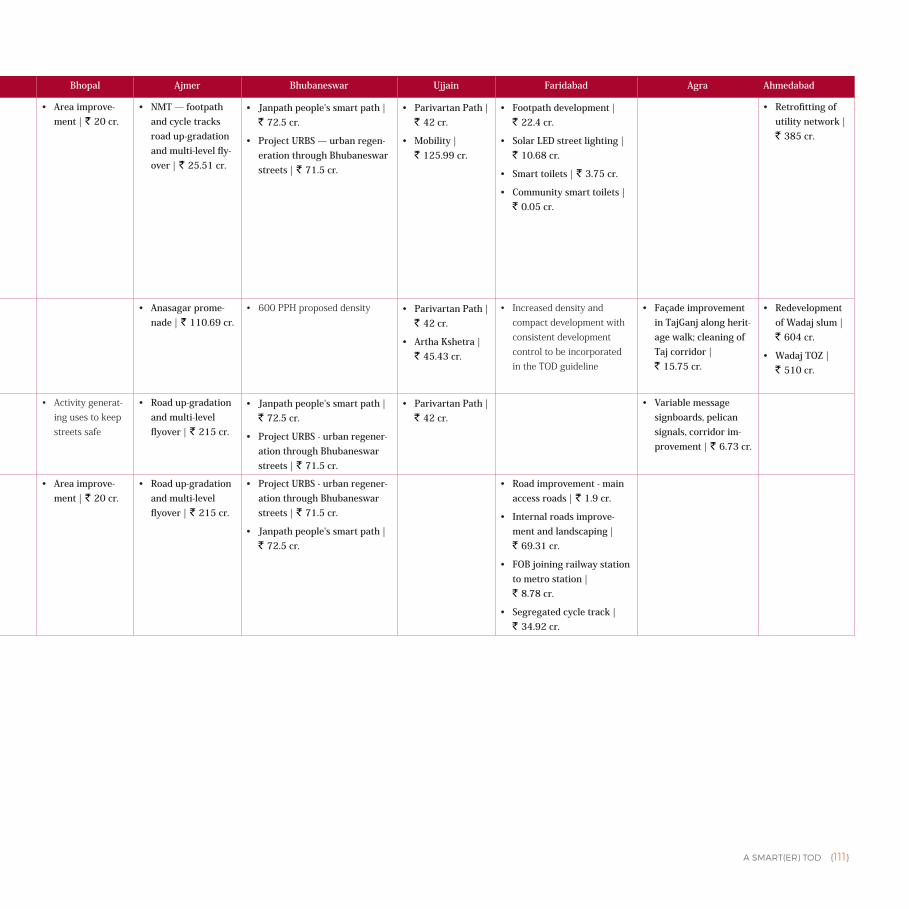
A SMART(ER) TOD {111}
Indore Panaji Ranchi Gwalior Bhopal Ajmer Bhubaneswar Ujjain Faridabad Agra Ahmedabad
Opt
imis
ed D
ensi
ties
• Safety and security — street lighting on major roads | ` 16.60 cr.
• Safety and security — street lighting on other local streets and pedestrian paths | ` 12.17 cr.
• Safety and security — lighting of public open spaces | ` 6.88 cr.
• Urban forestry, 5000 trees, My trees initiative | ` 0.36 cr.
• Pedestrianisation of 18th June Road, Street cafés on 18th June Road, pay parking, pedestrianisa-tion and artist zone at Café Bhosle square | ` 0.55 cr.
• Eco-mobility: public bike sharing scheme, sensor based LED street lighting improvement of open spaces, provision of public toilets, CNG/PNG network, 0.5 MW roof top solar PV | ` 67.67 cr.
• Highdensity(FAR>=4)Mediumdensity(FAR=4to2.5)Lowdensity(FAR<=2.5)
• Development of BRT corridor | ` 16 cr.
• Up-gradation of existing road network to full section development | ` 132.09 cr.
• Heritage network trail | ` 20.75 cr.
• Area improve-ment | ` 20 cr.
• NMT — footpath and cycle tracks road up-gradation and multi-level fly-over | ` 25.51 cr.
• Janpath people's smart path | ` 72.5 cr.
• Project URBS — urban regen-eration through Bhubaneswar streets | ` 71.5 cr.
• Parivartan Path | ` 42 cr.
• Mobility | ` 125.99 cr.
• Footpath development | ` 22.4 cr.
• Solar LED street lighting | ` 10.68 cr.
• Smart toilets | ` 3.75 cr.
• Community smart toilets | ` 0.05 cr.
• Retrofitting of utility network | ` 385 cr.
Stre
et O
rien
ted
Build
ing
• Redevelopment of public land | ` 2670.45 cr.
• IncreaseinfootfallwithmixoflanduseoncurrentlydesertedPattoside
• Heritage listing | ` 0.01 cr.
• Highdensity(FAR>=4)Mediumdensity(FAR=4to2.5)LowDensity(FAR<=2.5)
• TheTODPolicyDraftrecommendsprovid-ingadditionalFAR(3timestherestofthecity)asapremium
• Mixed-use TOD development under PPP • Anasagar prome-nade | ` 110.69 cr.
• 600PPHproposeddensity • Parivartan Path | ` 42 cr.
• Artha Kshetra | ` 45.43 cr.
• IncreaseddensityandcompactdevelopmentwithconsistentdevelopmentcontroltobeincorporatedintheTODguideline
• Façade improvement in TajGanj along herit-age walk; cleaning of Taj corridor | ` 15.75 cr.
• Redevelopment of Wadaj slum | ` 604 cr.
• Wadaj TOZ | ` 510 cr.
NM
T N
etw
ork • ABDhasactivestreetfrontagewith
retailingroundfloorsinmostofthebuildings
• Patto cultural zone funding sup-ported by EDC | ` 0.35 cr.
• Transport & circulation (roads) with pedestrian facility duct for utilities including gas line, power line, optical fibre, provision for sewerage & drainage | ` 209.83 cr.
• Mixed-use TOD development under PPP • Activitygenerat-ingusestokeepstreetssafe
• Road up-gradation and multi-level flyover | ` 215 cr.
• Janpath people's smart path | ` 72.5 cr.
• Project URBS - urban regener-ation through Bhubaneswar streets | ` 71.5 cr.
• Parivartan Path | ` 42 cr.
• Variable message signboards, pelican signals, corridor im-provement | ` 6.73 cr.
Traffi
c Ca
lmin
g
• Riverfront development — foot over bridges | ` 96 cr.
• Transport and walkability — vehicu-lar intersection improvements as per street design guidelines- mid block pedestrian junctions | ` 56 cr.
• ITS | ` 1.645 cr. • Transport & circulation (roads) with pedestrian facility duct for utilities including gas line, power line, optical fibre, provision for sewerage & drainage | ` 209.83 cr.
• Land development | ` 60.19 cr.
• Transit hub | ` 184.1 cr.
• Open spaces & parks (river park , eco park, lake harvest, neighbourhood park) | ` 49.4 cr.
• Up-gradation of existing road network to full section | ` 132.09 cr.
• Area improve-ment | ` 20 cr.
• Road up-gradation and multi-level flyover | ` 215 cr.
• Project URBS - urban regener-ation through Bhubaneswar streets | ` 71.5 cr.
• Janpath people's smart path | ` 72.5 cr.
• Road improvement - main access roads | ` 1.9 cr.
• Internal roads improve-ment and landscaping | ` 69.31 cr.
• FOB joining railway station to metro station | ` 8.78 cr.
• Segregated cycle track | ` 34.92 cr.
{112} A SMART(ER) TOD
Annexure II
ADDITIONAL SUB-COMPONENTS• Development (increase in population and built-up area) should be scaled to the population that the infrastructure can
support through an Impact Assessment (including traffic and environment impact) • Design streets as per IRC Standards for universal access • Design buildings as per NBC to allow universal access and utility • Provide clarity on all charges and levies up front • Ensure single window clearance for speed of approval • Overlay District can be used as an intermediate tool to delineate the TOD Influence Area and to implement TOD
Policies. It should eventually become a part of the Master Plan during the next revision. • If the city’s Master Plan is being revised, TOD Influence Area should be designated to enable the implementation of
TOD Policies in the future.
Endnotes1 Includes 14 cities that specifically identify TOD implementation in their SCP and 3 cities that illustrate land-use-
transportation integration, without recognising it as TOD.
2 The katras are proposed to be relocated at MCA (spell out) site near the existing skill development centre. Phase I of the
BRT corridor serves this area.
3 The Gunthewari Act of Maharashtra allows regularisation of Gunthewari developments (development of private lands for
construction of dwelling units in unauthorised areas — in this case of Nagpur, in green belt) existing on 1st January 2001.
4 Department of Tourism, Panaji: Government of Goa, 2011
5 Revised City Development Plan for Panaji, 2041
6 Smart City Plan of Panaji
7 Revised City Development Plan for Panaji 2041
8 Ibid.
9 Ibid. 2041
10 Goa Regional Plan 2021
11 The Economic and Socio-Cultural Balance Sheet of Tourism in Goa: Future Options
12 Revised City Development Plan for Panaji 2041
13 Ibid.
14 Transit Oriented Development Guidance Document
15 Ibid.
16 Ministry Of Urban Development, World Bank
17 Victoria Transport Policy Institute, 2016
18 CDP City Development Plan, Hubli-Dharwad, 2006
19 The state is formulating its affordable housing policy under the Housing for All Mission.
20 The detail of ongoing projects under these schemes is available at https://www.karnatakahousing.com/
Projects/225Scheme/225HousingSchemes.aspx
Karnataka Slum Clearance Board (KSCB), Karnataka Rajya Nirmana Kendra (KRNK) are other organisations working under
the administrative control of the housing department and are responsible for slum up-gradation, and improvement of their
quality of life by providing basic infrastructure facilities.
21 Housing for All, GoK Report
22 CTTP (https://WWW.scribd.com/document/153591460/Hubli-Dharwad-CTTP-Executive-Summary-pdf.com
23 It has so far developed 160 industrial areas in 29 Districts in the state covering an extent of 76,136 acres. It has acquired
more than 1,000 acres in Hubli-Dharwad.
24 Unavailable for review at the time of the publication
25 Status Progress Report RAY, March 2016, MoHUPA


A SMART(ER) TOD {6}
This study has been supported by generous grant from Prosperity Programme, Foreign & Commonwealth Office, Government of UK


![Bergamo as University City for a Smart[er] Learning Stefano Andreani Smart[er] Citizens Stefano Andreani Bergamo as University City for a Smart[er] Learning](https://img.pdfslide.us/doc/110x75/551ad917550346b2288b5f35/bergamo-as-university-city-for-a-smarter-learning-stefano-andreani-smarter-citizens-stefano-andreani-bergamo-as-university-city-for-a-smarter-learning.jpg)
![Smart[er] Smart Urban Safety & Security| Surveillance| Crime Prevention| Conflict Mediation| Healthcare Provision](https://img.pdfslide.us/doc/110x75/56649e6b5503460f94b6a1e5/smarter-smart-urban-safety-security-surveillance-crime-prevention-conflict.jpg)

![Bergamo as Health City for a Smart[er] Health Stefano Andreani Smart[er] Citizens Stefano Andreani Bergamo as Health City for a Smart[er] Health Smart[er]](https://img.pdfslide.us/doc/110x75/551ad91a550346856e8b6305/bergamo-as-health-city-for-a-smarter-health-stefano-andreani-smarter-citizens-stefano-andreani-bergamo-as-health-city-for-a-smarter-health-smarter.jpg)


![Smart[er] Nature GSD 6371 – Smart[er] Cities Pecha Kucha Presentation Ryn Burns MDesS, Critical Conservation jburns@gsd.harvard.edu](https://img.pdfslide.us/doc/110x75/56649efd5503460f94c1139d/smarter-nature-gsd-6371-smarter-cities-pecha-kucha-presentation-ryn.jpg)
![Bergamo as Health City for a Smart[er] Health Paolo Malighetti Smart[er] Citizens Paolo Malighetti Bergamo as Health City for a Smart[er] Health Smart[er]](https://img.pdfslide.us/doc/110x75/551ad914550346856e8b6303/bergamo-as-health-city-for-a-smarter-health-paolo-malighetti-smarter-citizens-paolo-malighetti-bergamo-as-health-city-for-a-smarter-health-smarter.jpg)

![Smart[er] Learning | Bergamo: The University City Cristina Grasseni Smart[er] Citizens Cristina Grasseni University of Bergamo SMART[ER] LEARNING | BERGAMO:](https://img.pdfslide.us/doc/110x75/551ad91455034606048b550a/smarter-learning-bergamo-the-university-city-cristina-grasseni-smarter-citizens-cristina-grasseni-university-of-bergamo-smarter-learning-bergamo.jpg)


![Smart [ er ] Event | Spectacles | Other Senses](https://img.pdfslide.us/doc/110x75/56813a00550346895da1c840/smart-er-event-spectacles-other-senses-568b6b7b3ef8a.jpg)


![Smart [ er ] Event | Spectacles | Other Senses](https://img.pdfslide.us/doc/110x75/56816134550346895dd08fb6/smart-er-event-spectacles-other-senses-56cb8133cfa94.jpg)
![Smart [ er ] Materials | Objects | Furniture](https://img.pdfslide.us/doc/110x75/56814577550346895db24768/smart-er-materials-objects-furniture-56954f520e509.jpg)
