Embed Size (px)
Citation preview

A Slope Stability Analysis using DEM and R/S DataMasataka TAKAGI IIS, Univ. of Tokyo
A Slope Stability Analysis using DEM & R/S Data
Masataka TAKAGIInstitute of Industrial Science,
The University of Tokyo.7-22, Roppongi, Minato-ku, Tokyo 106, JAPAN
Tel. +81-3-3402-6231Fax. +81-3-3479-2762
E-mail [email protected]://shiba.iis.u-tokyo.ac.jp/takagi
A Slope Stability Analysis using DEM and R/S DataMasataka TAKAGI IIS, Univ. of Tokyo
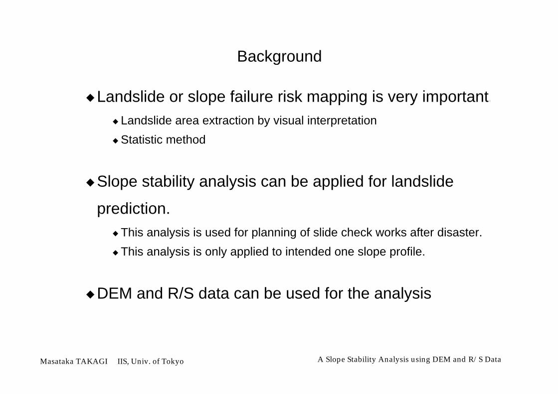
Background
Landslide or slope failure risk mapping is very important.Landslide area extraction by visual interpretation
Statistic method
Slope stability analysis can be applied for landslide
prediction.This analysis is used for planning of slide check works after disaster.
This analysis is only applied to intended one slope profile.
DEM and R/S data can be used for the analysis

A Slope Stability Analysis using DEM and R/S DataMasataka TAKAGI IIS, Univ. of Tokyo
Objectives
Feature extraction of Landslide area from DEM & RS data
Development of Landslide risk mapping method based on
slope stability analysis using DEM & RS data
Evaluation of DEM accuracy according to spatial
resolution for slope stability analysis

A Slope Stability Analysis using DEM and R/S DataMasataka TAKAGI IIS, Univ. of Tokyo
Materials
Test AreaShikoku Island in JAPAN
Digital Elevation Model50m Grid from 1 : 25000 Topographic Maps
Remote Sensing DataLANDSAT TM
Experimental DataLocation of Landslide by field survey
Soil Condition by experimentation

A Slope Stability Analysis using DEM and R/S DataMasataka TAKAGI IIS, Univ. of Tokyo
Topographic Feature

A Slope Stability Analysis using DEM and R/S DataMasataka TAKAGI IIS, Univ. of Tokyo
Shaded DEM with Geological Map
Sand-Stone
Meta-Diabase
Quartz-Schist

A Slope Stability Analysis using DEM and R/S DataMasataka TAKAGI IIS, Univ. of Tokyo
Drainage Pattern Map

A Slope Stability Analysis using DEM and R/S DataMasataka TAKAGI IIS, Univ. of Tokyo
Summit Level Map and Estimated Erosion Map
A Slope Stability Analysis using DEM and R/S DataMasataka TAKAGI IIS, Univ. of Tokyo
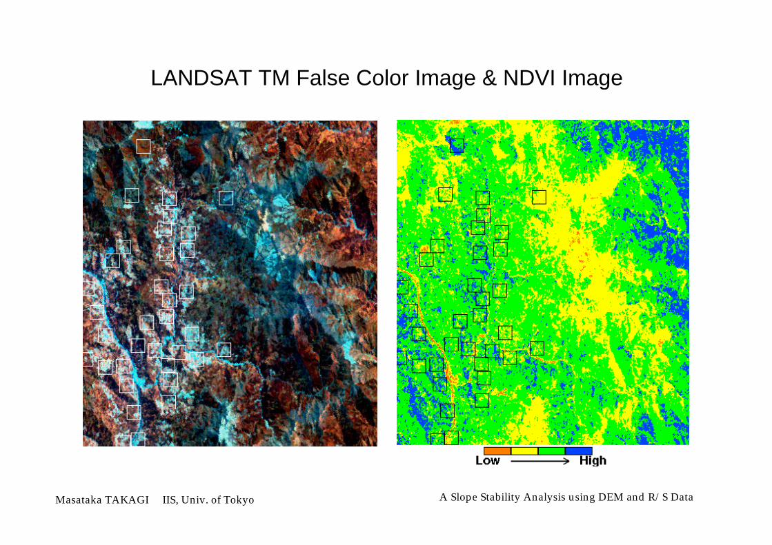
LANDSAT TM False Color Image & NDVI Image

A Slope Stability Analysis using DEM and R/S DataMasataka TAKAGI IIS, Univ. of Tokyo
Land cover Map by MLC with Training Data

A Slope Stability Analysis using DEM and R/S DataMasataka TAKAGI IIS, Univ. of Tokyo
Slope Stability Analysis
Number ofUnknown
Coefficients
Method Fs
Fellenius 1927 5n - 1 1.43
Bishop 1955 6n 1.54
Jamb 1957 7n - 1 1.63
Morgenstern 1965 7n - 1 1.63n: Number of Slice
6.1m γ = 2 t/m
C = 0.439 t/m
φ =32゜
2
3
t

A Slope Stability Analysis using DEM and R/S DataMasataka TAKAGI IIS, Univ. of Tokyo
Fellenius Method
Length of Landslide
D
DEM Grid
R
T = R • W • sin
N = R (C•L + tan • W • cos )
Driving Moment
Resistance Moment
Safety Factor
Fs =N
T
W
αN
T
Illustration ofEach Slice
L
C: Cohesionφ: Angle of Shearing Resistance

A Slope Stability Analysis using DEM and R/S DataMasataka TAKAGI IIS, Univ. of Tokyo
Flow Chart of Slope Stability Analysis
Draw upProfile
Search theSteepest Slope
Direction
Calculation
Determinationof
Parameters
Mapping
Target Pixel
Pixel
DEM
Length of Landslide
D
DEM Grid
R

A Slope Stability Analysis using DEM and R/S DataMasataka TAKAGI IIS, Univ. of Tokyo
Soil Condition
Quartz-Schist 2.0 15
Meta-Diabase 3.0 20
Sand-Stone 4.0 25
Geology φ (°)C (t/m )2t
γ (t/m )3
1.9
1.9
1.9

A Slope Stability Analysis using DEM and R/S DataMasataka TAKAGI IIS, Univ. of Tokyo
Influence of Water Content
0
2
4
6
8
10
5 10 15 20 25 30 35 40
Angle of Shearing Resistance (°)
Saturated SoilUnsaturated Soil
Land cover
Water Area 0.5
Grass Land 0.7
Forest Area 1.0
Bare Soil Area 1.0
Reduction Ratiofor Cohesion

A Slope Stability Analysis using DEM and R/S DataMasataka TAKAGI IIS, Univ. of Tokyo
Landslide Risk Map

A Slope Stability Analysis using DEM and R/S DataMasataka TAKAGI IIS, Univ. of Tokyo
Evaluation of DEM accuracy according to Spatial Resolution
Original DEM
50 m Grid DEM from 1 : 25000 maps
Preparation of Various Grid Size DEM from Original DEM
100 m Grid
150 m Grid
200 m Grid
250 m Grid
Resampling method
Nearest Neighbor
Mean Value
Maximum Value
Minimum value
Shaded 50m grid DEM of Test Area
Shaded 250m grid DEM of Test Area(Nearest Neighbor Resampling)

A Slope Stability Analysis using DEM and R/S DataMasataka TAKAGI IIS, Univ. of Tokyo
Evaluation Result of Slope inclination accuracy
20
10
0
Difference from Original Data (Degree)-40 -20 0 20 40 60 80
40
30
20
10
Spatial Resolution (Grid Size [m] )100 150 200 250
■ Nearest Neighbor● Mean Value▼ Maximum Value▲ Minimum Value
100m Grid150m Grid200m Grid250m Grid
Original Data - Resampled Data

A Slope Stability Analysis using DEM and R/S DataMasataka TAKAGI IIS, Univ. of Tokyo
Evaluation Result of DEM accuracy
20
10
0
Difference from Original Data (Fs)-1.2 -1 -0.8-0.6-0.4-0.2 0 0.2 0.4 0.6 0.8 1 1.2
60
50
40
30
Spatial Resolution (Grid Size [m] )100 150 200 250
■ Nearest Neighbor● Mean Value▼ Maximum Value▲ Minimum Value
100m Grid150m Grid200m Grid250m Grid
Original Data - Resampled Data

A Slope Stability Analysis using DEM and R/S DataMasataka TAKAGI IIS, Univ. of Tokyo
Conclusions
Development of slope stability analysis using DEM and
R/S data.Result showed very high accuracy
Developed method will be very helpful for prediction of landslides
potential
Evaluation of DEM accuracy according to spatial
resolutionNearest Neighbor resampling should be used for DEM generation
Wide grid made gentle slope because of undulation in even one pixel
High accurate DEM was required for slope stability analysis