Embed Size (px)
Citation preview
A Sinking Coast Bubbles up Legal Challenges Victor J. Franckiewicz, Jr., Butler Snow LLP
New Orleans Bar Association CLE
December 30, 2014, 3:30 – 4:30 Pan American Life Conference Center
601 Poydras St., 11th floor
A Sinking Coast Bubbles up Legal Challenges December 30, 2014 New Orleans Bar Association CLE
presented by
Victor J. Franckiewicz, Jr., Butler Snow LLP
Introduction
The deteriorating condition of Louisiana’s coastline is
one of the most pressing problems affecting the future
occupancy of southern Louisiana. According to the
state’s 2012 Comprehensive Master Plan for a
Sustainable Coast:
Louisiana is in the midst of a land loss crisis
that has claimed 1,880 square miles of land
since the 1930s. . . . If we do not aggressively
address this crisis, the problem intensifies . . .
This land loss will increase flooding risk with
disastrous effects.
. . .
Every day Louisiana citizens are affected by
this catastrophe in ways small and large.
Whether it is families that must leave
cherished communities to move out of harm’s
way, local businesses that have trouble
obtaining insurance, or investments that lose
value because of uncertainty about the future
of our landscape, Louisiana’s land loss disaster
takes a heavy toll.
The dynamic physical condition of the coast and the
likelihood that the problem will continue for at least the
next 70 years produces a package of legal issues:
Property rights related to subsiding, eroding,
submerging, and accreting land and waterbottoms
Regulatory impacts to developing and living in
coastal areas subject to flooding
Recovery from disasters and retreat from a
shrinking coastline
Factual Background
The unstable state of affairs on the coast is commonly
attributed to the aggressive control of the Mississippi
River system beginning in the late 19th
and early 20th
centuries, and pursued with a vengeance following the
disastrous 1927 Mississippi River flood.1 But an
1 Attempts to control the Mississippi River had been
underway to some extent from the first European exploration
and settlement of the region beginning in 1699. However, as
unstable coast with a high exposure to deadly disasters
is not a contemporary phenomenon. Southern
Louisiana has been so frequently devastated by
hurricanes throughout recorded history that periodic
disastrous storms should be considered the norm:
Hurricane Katrina may be the most memorable
storm in New Orleans history, but its trajectory
across the Pelican State was far from unique.
Louisiana was hit by 49 of the 273 hurricanes
that made landfall on the American Atlantic
Coast between 1851 and 2004. In addition,
eighteen of the ninety-two major hurricanes
with Saffir-Simpson ratings of category 3 or
above have struck the state. On average, one
major storm crosses within 100 nautical miles
of New Orleans every decade.2
A turning point in New Orleans’ development was the
hurricane of 1722. It effectively wiped the then-infant
settlement of New Orleans clean and paved the way to
implement the orderly layout of the historic French
Quarter surveyed by Andrea de Pauger. The next
century saw a tragic calamity involving Isle Derniere:
In the early 1850’s, Isle Derniere was a rapidly
developing resort community. Situated in the
Gulf of Mexico, ninety miles southeast of New
Orleans and ten miles off the coast of
Terrebonne Parish, the twenty-five mile island
was gaining a reputation as a popular
destination for the socially and politically elite
from across southern Louisiana.
. . .
The twenty-five mile island boasted a fine
hotel, The St. Charles, which stretched twelve
hundred feet along the beach, plus rental
cottages. Though not as architecturally lavish
as its counterpart in New Orleans, The St.
the 1927 flood demonstrated, those efforts were not fully
successful until the federal government ratcheted up the effort
to control flooding in the Mississippi valley on a
comprehensive basis. 2 See “New Orleans Hurricane History” at
http://web.mit.edu/12.000/www/m2010/teams/neworleans1/h
urricane%20history.htm. Last visited 12/29/14. Internal
citations omitted.
- 2 -
Charles was lauded for its “comfort, pleasant
and spacious rooms, [and] good eating of
every kind, including oysters, terrapins and
fish of every variety.”3
The fun was short-lived. A devastating hurricane
struck in August 1856, obliterating the luxury resort,
drowning about half of the 400 guests. The island was
severely eroded in that and subsequent hurricanes.
Today, the once 25-mile long island consists of small
uninhabited remnants: Wine, Raccoon, Whiskey,
Trinity, and East Islands.
The disappearance of the Isle Derniers resort isn’t unique
in the region. A similar, but less catastrophic, fate
happened at the Isle of Caprice off the Mississippi coast:
Dog Key Island, which was only three miles
long and about 487 acres, had been used for
years by local fishermen because artesian
springs were there, providing fresh water.
During Prohibition it became a haven for
bootleggers. Realizing its importance because
of the fresh water supply and its location
twelve miles outside of the jurisdiction of
United States claims, three men . . . financed
the Isle of Caprice Hotel and Resort that was
built on Dog Key in 1926. . . . The Isle of
Caprice was very popular until storms and the
Gulf of Mexico’s currents took their toll on the
sandy Dog Key. Adding to the environmental
problems, people visiting the island picked the
sea oats that somewhat stabilized the island’s
sand. As a result, the fragile ecosystem
maintained by the plants’ root systems was
destroyed. By 1932, the Isle of Caprice Resort
was completely submerged.4
Further east is the Petit Bois Island. In the 1850’s, it
was several miles off the Alabama coast almost entirely
within that boundaries of Alabama. Only its
westernmost end extended across the state line into
Mississippi. But by the early 1900s, the island had
migrated several miles to the west, and now lies entirely
within the boundaries of Mississippi.
These geographic vignettes – and countless more like
them – illustrate that the dynamic nature of the coast is
nothing new. The Mississippi River Delta that forms
3 Louisiana Coastal Restoration: Challenges and
Controversies, 27 S.U. L. Rev. 149, 150 (Spring 2000) 4 Gambling in Mississippi: Its Early History, Deanne S.
Nuwer
http://mshistorynow.mdah.state.ms.us/articles/80/gambling-
in-mississippi-its-early-history (Last visited 12/27/14).
the greater part of south Louisiana has wandered across
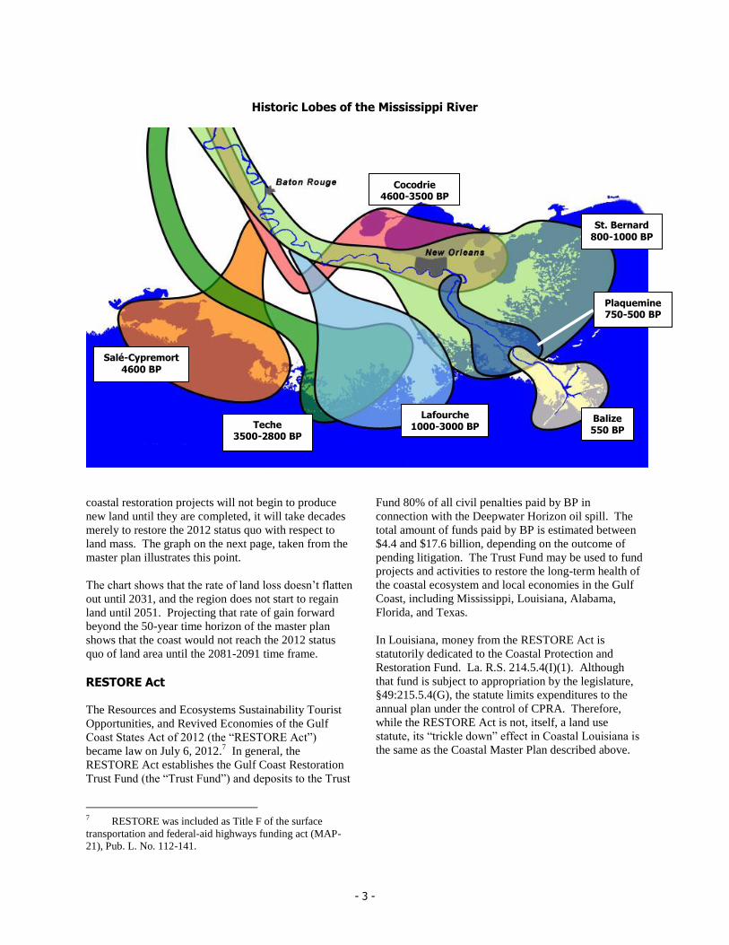
the width of modern-day state for eons. The illustration
on the next page shows this movement over thousands
of years as variously named “lobes” of the delta were
created and abandoned by the forces of nature, long
before European settlers built the first crude levee. This
drives home the point that the shifting coast is not a
new phenomenon (time epochs shown as years before
the present, “BP”).5
Louisiana’s Coastal Master Plan
In a December 2005 special session to address recovery
issues following Hurricanes Katrina and Rita, the
Louisiana Legislature restructured the state’s Wetland
Conservation and Restoration Authority to form the
Coastal Protection and Restoration Authority (CPRA).
2005 1st Ex. Session Act 8. The legislature tasked
CPRA with coordinating local, state, and federal efforts
to achieve comprehensive coastal protection and
restoration. Specifically La. R.S. 49:214.5.3 requires
the CPRA to prepare a “master plan for integrated
coastal protection” and an annual funding plan to be
submitted to the legislature. The master plan must be
reviewed and amended at least every five years. La.
R.S. 49:214.5.3(A)(1).
The first master plan was published in 2007. Under the
statutory five-year update schedule, an extensive 2012
Coastal Master Plan was developed based on a two year
analysis by prominent Louisiana scientists supported by
national and international specialists. The state used
this analysis to select 109 projects estimated to cost $50
billion, split roughly evenly between protection and
restoration projects.6 Work on the 2017 update is in its
early stages.
The 2012 plan estimates that Louisiana would start
gaining land in about 30 years if all of the restoration
projects are implemented. Such a gain would be the
first time since the 1930s. This sounds good, but
gratification will be deferred. Because historical land
loss will continue for some time to come, and because
5 Sources: USGS National Wetlands Research Center,
“Barrier Islands” publication, with information derived from
Kolb,van Lopik (1958), Geology of the Mississippi River
deltaic plain, southeastern Louisiana, Technical Report 3-483,
Vicksburg, MS: U.S. Army Corps of Engineers Waterways
Experiment Station; Kulp, M. A., Howell, P., Adiau, S.,
Penland, S., Kindinger, J., and Williams, S. J., 2002, Latest
Quaternery stratigraphic framework of the Mississippi delta
region: Gulf Coast Association of Geological Societies
Transactions, v. 52, p. 573-582. 6 The 2012 plan is available at
http://www.coastalmasterplan.la.gov.
- 3 -
Historic Lobes of the Mississippi River
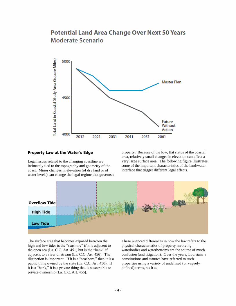
coastal restoration projects will not begin to produce
new land until they are completed, it will take decades
merely to restore the 2012 status quo with respect to
land mass. The graph on the next page, taken from the
master plan illustrates this point.
The chart shows that the rate of land loss doesn’t flatten
out until 2031, and the region does not start to regain
land until 2051. Projecting that rate of gain forward
beyond the 50-year time horizon of the master plan
shows that the coast would not reach the 2012 status
quo of land area until the 2081-2091 time frame.
RESTORE Act
The Resources and Ecosystems Sustainability Tourist
Opportunities, and Revived Economies of the Gulf
Coast States Act of 2012 (the “RESTORE Act”)
became law on July 6, 2012.7 In general, the
RESTORE Act establishes the Gulf Coast Restoration
Trust Fund (the “Trust Fund”) and deposits to the Trust
7 RESTORE was included as Title F of the surface
transportation and federal-aid highways funding act (MAP-
21), Pub. L. No. 112-141.
Fund 80% of all civil penalties paid by BP in
connection with the Deepwater Horizon oil spill. The
total amount of funds paid by BP is estimated between
$4.4 and $17.6 billion, depending on the outcome of
pending litigation. The Trust Fund may be used to fund
projects and activities to restore the long-term health of
the coastal ecosystem and local economies in the Gulf
Coast, including Mississippi, Louisiana, Alabama,
Florida, and Texas.
In Louisiana, money from the RESTORE Act is
statutorily dedicated to the Coastal Protection and
Restoration Fund. La. R.S. 214.5.4(I)(1). Although
that fund is subject to appropriation by the legislature,
§49:215.5.4(G), the statute limits expenditures to the
annual plan under the control of CPRA. Therefore,
while the RESTORE Act is not, itself, a land use
statute, its “trickle down” effect in Coastal Louisiana is
the same as the Coastal Master Plan described above.
Salé-Cypremort
4600 BP
Cocodrie 4600-3500 BP
Teche 3500-2800 BP
St. Bernard
800-1000 BP
Lafourche 1000-3000 BP
Plaquemine 750-500 BP
Balize 550 BP
- 4 -
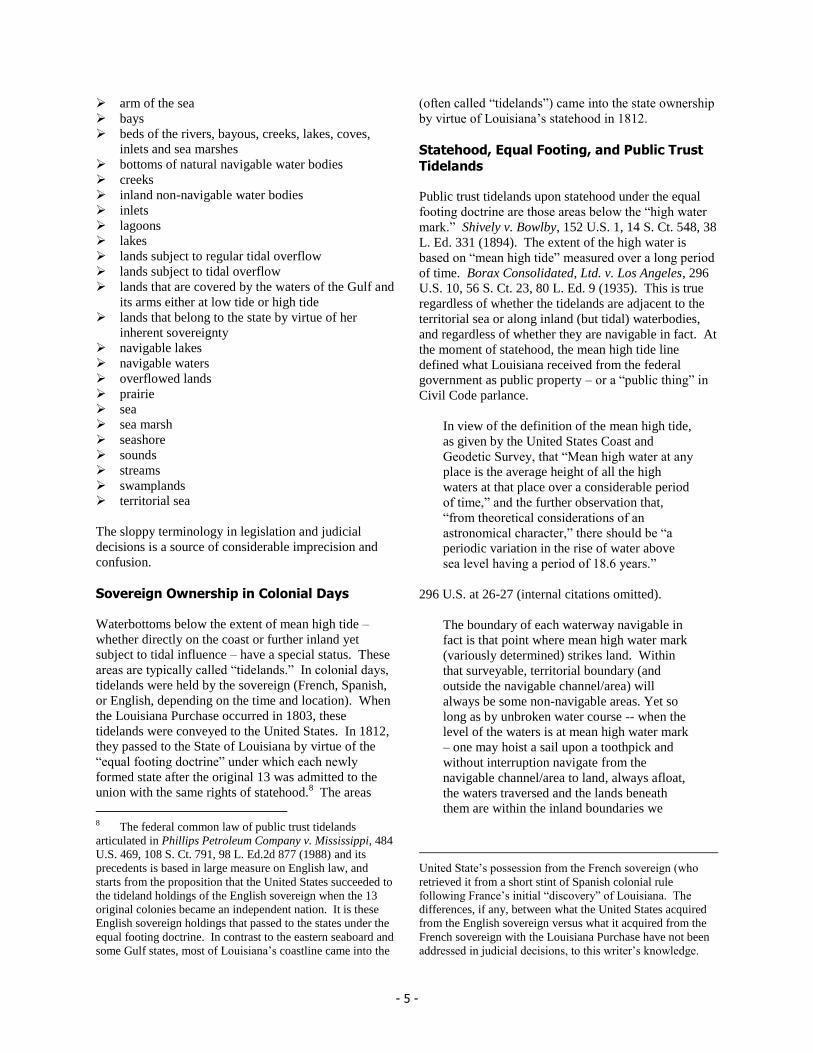
Property Law at the Water’s Edge
Legal issues related to the changing coastline are
intimately tied to the topography and geometry of the
coast. Minor changes in elevation (of dry land or of
water levels) can change the legal regime that governs a
property. Because of the low, flat status of the coastal
area, relatively small changes in elevation can affect a
very large surface area. The following figure illustrates
some of the important characteristics of the land/water
interface that trigger different legal effects.
The surface area that becomes exposed between the
high and low tides is the “seashore” if it is adjacent to
the open sea (La. C.C. Art. 451) but is the “bank” if
adjacent to a river or stream (La. C.C. Art. 456). The
distinction is important. If it is a “seashore,” then it is a
public thing owned by the state (La. C.C. Art. 450). If
it is a “bank,” it is a private thing that is susceptible to
private ownership (La. C.C. Art. 456).
These nuanced differences in how the law refers to the
physical characteristics of property involving
waterbodies and waterbottoms are the source of much
confusion (and litigation). Over the years, Louisiana’s
constitutions and statutes have referred to such
properties using a variety of undefined (or vaguely
defined) terms, such as
Low Tide
High Tide
Overflow Tide
- 5 -
arm of the sea
bays
beds of the rivers, bayous, creeks, lakes, coves,
inlets and sea marshes
bottoms of natural navigable water bodies
creeks
inland non-navigable water bodies
inlets
lagoons
lakes
lands subject to regular tidal overflow
lands subject to tidal overflow
lands that are covered by the waters of the Gulf and
its arms either at low tide or high tide
lands that belong to the state by virtue of her
inherent sovereignty
navigable lakes
navigable waters
overflowed lands
prairie
sea
sea marsh
seashore
sounds
streams
swamplands
territorial sea
The sloppy terminology in legislation and judicial
decisions is a source of considerable imprecision and
confusion.
Sovereign Ownership in Colonial Days
Waterbottoms below the extent of mean high tide –
whether directly on the coast or further inland yet
subject to tidal influence – have a special status. These
areas are typically called “tidelands.” In colonial days,
tidelands were held by the sovereign (French, Spanish,
or English, depending on the time and location). When
the Louisiana Purchase occurred in 1803, these
tidelands were conveyed to the United States. In 1812,
they passed to the State of Louisiana by virtue of the
“equal footing doctrine” under which each newly
formed state after the original 13 was admitted to the
union with the same rights of statehood.8 The areas
8 The federal common law of public trust tidelands
articulated in Phillips Petroleum Company v. Mississippi, 484
U.S. 469, 108 S. Ct. 791, 98 L. Ed.2d 877 (1988) and its
precedents is based in large measure on English law, and
starts from the proposition that the United States succeeded to
the tideland holdings of the English sovereign when the 13
original colonies became an independent nation. It is these
English sovereign holdings that passed to the states under the
equal footing doctrine. In contrast to the eastern seaboard and
some Gulf states, most of Louisiana’s coastline came into the
(often called “tidelands”) came into the state ownership
by virtue of Louisiana’s statehood in 1812.
Statehood, Equal Footing, and Public Trust
Tidelands
Public trust tidelands upon statehood under the equal
footing doctrine are those areas below the “high water
mark.” Shively v. Bowlby, 152 U.S. 1, 14 S. Ct. 548, 38
L. Ed. 331 (1894). The extent of the high water is
based on “mean high tide” measured over a long period
of time. Borax Consolidated, Ltd. v. Los Angeles, 296
U.S. 10, 56 S. Ct. 23, 80 L. Ed. 9 (1935). This is true
regardless of whether the tidelands are adjacent to the
territorial sea or along inland (but tidal) waterbodies,
and regardless of whether they are navigable in fact. At
the moment of statehood, the mean high tide line
defined what Louisiana received from the federal
government as public property – or a “public thing” in
Civil Code parlance.
In view of the definition of the mean high tide,
as given by the United States Coast and
Geodetic Survey, that “Mean high water at any
place is the average height of all the high
waters at that place over a considerable period
of time,” and the further observation that,
“from theoretical considerations of an
astronomical character,” there should be “a
periodic variation in the rise of water above
sea level having a period of 18.6 years.”
296 U.S. at 26-27 (internal citations omitted).
The boundary of each waterway navigable in
fact is that point where mean high water mark
(variously determined) strikes land. Within
that surveyable, territorial boundary (and
outside the navigable channel/area) will
always be some non-navigable areas. Yet so
long as by unbroken water course -- when the
level of the waters is at mean high water mark
– one may hoist a sail upon a toothpick and
without interruption navigate from the
navigable channel/area to land, always afloat,
the waters traversed and the lands beneath
them are within the inland boundaries we
United State’s possession from the French sovereign (who
retrieved it from a short stint of Spanish colonial rule
following France’s initial “discovery” of Louisiana. The
differences, if any, between what the United States acquired
from the English sovereign versus what it acquired from the
French sovereign with the Louisiana Purchase have not been
addressed in judicial decisions, to this writer’s knowledge.
- 6 -
consider the United States set for the
properties granted the State in trust.”
Cinque Bambini Partnership v. State, 491 So.2d 508,
151 (Miss. 1986); affirmed, Phillips Petroleum
Company v. Mississippi, 484 U.S. 469, 108 S. Ct. 791,
98 L. Ed.2d 877 (1988).
This is the point where legal regimes at the water’s
edge get complicated. Louisiana law does not use the
mean high tide line to differentiate public from private
things. Instead, the Civil Code refers to “the highest
tide during the winter season,” and then only with
respect where the “waters of the sea spread.” La. C.C.
Art. 451. The “highest tide during the winter season”
does not necessarily correspond to “mean high tide.”
The difference – higher or lower – depends on the
location, as tidal behavior is a complicated function of
lunar cycles, topography, and hydrology. Further, the
Civil Code is silent about the status of tidelands that are
not “seashore” under La. C.C. Art. 451, leaving these
other tidelands outside of the protective cloak afforded
to “public things” by the Civil Code.
There is another mismatch between the statehood
concept of public trust tidelands and Louisiana law
regarding the use of the term “navigable waters.” As
important as that term is when dealing with coastal
issues, it is not defined by positive Louisiana law, to
this writer’s knowledge. It is defined – vaguely – in a
number of judicial decisions:
A body of water is navigable in law when it is
navigable in fact. E.g., State v. Jefferson Island
Salt Mining Co., 183 La. 304, 163 So. 145
(1935). The factual question turns on whether
the evidence shows a body of water to be
suitable by its depth, width and location for
commerce. E.g., State v. Capdeville, 146 La.
94, 83 So. 421 (1919), cert. denied. A stream,
to be navigable must be usable for commerce
in its natural state or ordinary condition. E.g.,
Delta Duck Club v. Barrios, 135 La. 357, 65
So. 489 (1914); The Daniel Ball, 10 Wall 557,
19 L. Ed. 999 (1870).
Vermilion Bay Land Co. v. Phillips Petroleum Co., 646
So.2d 408, 413 (La. App. 4 Cir. 1994)
Swamp and Overflowed Lands Acts, 1849 and 18509
In 1849, the U.S. Congress granted to Louisiana “those
swamp and overflowed lands, which may be or are
found unfit for cultivation.” 9 Stat. 352 (1849). The
purpose of the statute was to “aid the State of Louisiana
in constructing the necessary levees and drains to
reclaim the swamp and overflowed land therein . . .”
This statute was the prototype for subsequent
swampland acts by which Congress granted wetlands to
the states.
States with large amounts of wetlands, such as Illinois,
Michigan, and Florida, where only half the land was
considered suitable for farming, joined a general move
to have federal swamplands ceded to them. This led
Congress to pass the Swamp Land Act of 1850, the
intent of which was to enable Arkansas, Alabama,
California, Florida, Illinois, Indiana, Iowa, Michigan,
Mississippi, Missouri, Ohio, and Wisconsin to reclaim
the swamplands within their boundaries (9 Stat. 519,
1850). The statutes are codified in 43 U.S.C. §§ 981 et
seq. (1988).
The Swamp Land Act’s vague definition – “wet and
unfit for cultivation” – led to substantial litigation.
Almost 200 swampland cases reached the Supreme
Court by 1888.
The timing of the swamp and overflowed lands acts is
important to understanding the ownership status of
lands and waterbottoms in Louisiana. The “swamp and
overflowed lands” transferred to Louisiana by the
federal government later became the source of land
patents granted by the state to private parties under state
legislation. That legislation authorized the sale of those
same lands, with the state authorizing statutes typically
identifying the lands granted by the various federal acts
from 1849 forward. By the time the federal
government began transferring swamp lands to
Louisiana beginning with the 1849 act, it had already
divested itself of Louisiana’s tidelands by virtue of
Louisiana’s statehood in 1812. Accordingly, none of
the public trust tidelands acquired in 1812 were
included in any of the swamp lands acquired under the
1849 and later swamp land acts. It follows that when
the state subsequently patented to private parties those
lands received from the federal government as swamp
9 The source of the historical description in this section is
primarily WETLANDS: CHARACTERISTICS AND BOUNDARIES, p.
44. (Committee on Characterization of Wetlands, National
Research Council, 1995). Available at:
http://www.nap.edu/openbook.php?record_id=4766&page=44
. (Last checked: 12/27/14.)
- 7 -
lands, the patents would not have included tidelands,
unless there was a separate conveyance of the tidelands
to the private parties.10
Many more constitutional and statutory enactments
have impacted property law related to tidelands and
waterbottoms in Louisiana for over one and a half
centuries. A more detailed compendium of relevant
law is provided at the end of this paper.
Judicial Decisions
Numerous reported judicial decisions obliquely address
coastal protection and restoration issues. It is not
surprising that much of the litigation over waterbottom
ownership and the relative rights and obligations of
private versus public persons involves disputed mineral
rights; that’s where the money is. But in the process of
adjudicating mineral rights, Louisiana’s courts have had
to come to grips with the underlying principles of
property law at the water’s edge. Indirectly, those
decisions address what the state and its political
subdivisions can do to further coastal protection and
restoration.
The large volume of reported decisions are difficult to
wade through, in part because of fact intense nuances
inherent in property descriptions and conveyancing and
in part because of significant judicial flip-flops as
disputes move up the appellate ladder or as similar
cases are decided differently over time. Some
significant examples:
Gulf Oil Corp. V. State Mineral Bd., 317 So.2d 576
(La. 1975) held that state land patents did not
convey land beneath navigable waters within the
boundaries of a described tract, and that “any
alienation or grant of the title to navigable waters
by the legislature must be express and specific and
is never implied or presumed rom general language
in a grant or statute.” Id. at 589. This overruled
California Co. v. Price, 74 So. 2d 1 (La. 1954) and
10 In some instances, the state expressly conveyed tidelands
in addition to the 1949 swamp lands. For example, by Act
No. 18 of 1894, the legislature created the Buras Levee
District on the west bank of Plaquemines Parish, and
transferred to that district all lands granted to Louisiana by the
United States as swamp or overflowed land, and all lands that
had been forfeited to or bought in by the state for delinquent
taxes, within the levee. Later, by Act No. 205 of 1910, the
state transferred as additional property “all lands within the
district belonging to the State by virtue of her inherent
sovereignty.” State v. Gulf Refining Co., 13 So. 2d 277 (La.
1943). Thus, the Buras Levee District acquired all swamp or
overflowed lands and all tidelands. as separate classes of
property.
State v. Cenac, 132 So.2d 928, 241 La. 1055 (La.,
1961).
Miami Corporation v. State, 186 La. 784, 173 So.
315 (La. 1936) held that waterbottoms created by
the erosion of the shoreline of a navigable
waterbody (Grand Lake, Cameron Parish) became
public property. This overruled State v. Erwin, 173
La. 507, 138 So. 84 (La. 1931 ), which itself had
overruled New Orleans Land Co. v. Board of Levee
Commissioners of Orleans Levee District, 171 La.
718, 132 So. 121 (La. 1930).
Despite the complexities and historically shifting
judicial opinions, several principles pertinent to coastal
protection and restoration emerge from the body of
reported decisions:
As privately owned dry land erodes and becomes
part of a navigable waterbody, ownership of that
area converts to the state.
Once the area becomes part of the navigable
waterbody, it becomes inalienable.
The state (or its delegated political subdivisions)
may fill waterbottoms that it owns to create new
land, and ownership of that new land is retained by
the public; it does not accrete to adjoining private
owners.
New land that naturally accretes on the sea or an
arm of the sea belongs to the state, even though if
may front on privately owned land.
However, new land that naturally accretes along
rivers or streams belongs to the adjacent upland
owner.
Changes in ownership as a result of accretion,
dereliction, erosion, subsidence, or other conditions
resulting from the action of navigable waterbodies
do not change mineral servitudes in force at the
time of the change. La. R.S. 9:1151 (commonly
called the “Freeze Statute”).
Where new land naturally accretes at the
confluence of a river or stream and the sea or arm
of the sea, courts have to make an equitable
division of the ownership based on an assessment
of how much of the accretion relates to riverbank
versus the seashore, based on the underlying
principles of La. C.C. Art. 501. Davis Oil Co. v.
The Citrus Land Co., 576 So. 2d 495 (La. 1991).
Louisiana law related to the ownership of non-
navigable tidelands is undeveloped. Until the
Phillips Petroleum case prompted La. R.S.
9:1115.1 through 1115.3, positive Louisiana law
did not address this genre of the land/water

- 8 -
interface. 9:1115.2(B) declares that inland non-
navigable water beds or bottoms are susceptible of
private ownership (an issue that had been the
subject of academic debate following the Phillips
Petroleum decision.) While tidelands are declared
susceptible of private ownership, the statute does
not convey such tidelands still in state ownership
by virtue of their transfer upon statehood. As
enacted 9:1115.3 establishes a retroactive
presumption that any conveyance from the state of
immovable property that encompasses inland non-
navigable waterbottoms conveys ownership of the
bottoms. However, a savings clause in 9:1115.3
declares that the statute does not convey land not
previously conveyed to by the state. So while the
statutory presumption aids private owners in
proving ownerships claims asserted against the
state, it does not result in any actual conveyance of
property.
As outlined above, applying property law at the water’s
edge is often sloppy and always fact intense. It is a
difficult body of law to grasp comprehensively.
Fortunately, a number of law journal articles provide
useful overviews that are tough to glean from reported
decisions, and are presented here for the reader’s
reference:
Ryan M. Seidemann, Curious Corners of
Louisiana Mineral Law: Cemeteries, School
Lands, Erosion, Accretion, and other Oddities, 23
Tul. Envtl. L.J. 93 (2009).
Judith Perhay, Louisiana Coastal Restoration:
Challenges and Controversies, 27 S.U. L. Rev. 149
(2000).
Marc C. Hebert, Coastal Restoration under
CWPPRA and Property Rights Issues, 57 La. L.
Rev. 1165 (1997).
Lee Hargrave, The Public Trust Doctrine: A Plea
for Precision, 53 La. L. Rev. 1535 (1993).
Lawrence E. Donohoe, JR. and Patrick G. Tracy,
Jr., Phillips Petroleum Co. v. Mississippi: the
Louisiana State Law Institute’s Advisory Opinion
Relative to Non-Navigable Waterbottoms, 53 La. L.
Rev. 35 (1992)(referenced by the legislature as the
basis for La. R.S. 9:1115.1, et seq.).
James G. Wilkins and Michael Wascom, The
Public Trust Doctrine in Louisiana, 52 La. L. Rev.
861 (1992).
Developing, Redeveloping and Relocating
Coastal Hazard Areas
After Hurricanes Katrina and Rita, civic leadership
across southern Louisiana was resolute about how
recovery should be approached. Several recurring
themes were commonly heard:
This calamity should be an impetus for a
community development plan allowing for
economic growth and resurgence.
We need to guarantee preparedness in the event of
another disaster.
Rather than supporting unchecked growth,
development should be steered to reduce
vulnerability of local residents and communities.
Hazard mitigation policies should be implemented
to minimize development in high risk areas and
direct new development to safer locations.
Local governments need to pool their resources and
provide infrastructure and services on a
coordinated, regional basis.
These pleas for a better approach to development
following a disaster should sound familiar. A chorus of
civil leadership across Louisiana raised them publically
and repeatedly after Hurricanes Katrina and Rita. But it
was the second verse of an old song. Those with good
memories may recall the similar statements more than
45 years ago after Hurricane Camille devastated the
Mississippi Gulf Coast in 1969.11
That catastrophe
prompted ground-breaking legislation in 1971 when
Mississippi enacted the Gulf Regional District Law,
Miss. Code Ann. § 17-11-1, et seq., that allowed local
governments to pool resources to address area-wide
recovery problems by regional cooperation within the
framework of local control. The statute was never
utilized.
The same conditions existed after Hurricane Katrina.
Just as in the aftermath of Hurricane Camille decades
earlier, new laws were passed that allowed local
governments to utilize their resources for recovery. This
time, more of the concept turned into reality, but still not
nearly as much as had been envisioned decades earlier.
Notwithstanding that governments haven’t been good
students of history, disasters still present major
challenges and opportunities for rebuilding. And
disasters are highly likely to occur with increasing
frequency and severity until the region successfully
11 The list above was drawn from news articles published
after Hurricane Camille.
- 9 -
reverses and erases nearly a century of major land loss
– a process that will easily take 70 years or more – even
if the state’s coastal master plan hits its mark..
Disasters typically bring a significant influx of federal
dollars for local communities. Federal Emergency
Management Agency (FEMA) and Community
Development Block Grant (CDBG) programs are the
prime conduits of federal funding after disasters. Both
of these sources have built up a cadre of disaster
response professionals in both the public and private
sectors who are highly knowledgeable about the
nuances of the programs. They are invaluable
resources.
FEMA funding is geared toward cleanup, repair, and
restoration. It does not have a lot of flexibility. But it
does have the advantage of being exempt in some
respects from many environmental review procedures
that can be extremely burdensome in a post-disaster
setting. In contrast, CDBG funding is much more
flexible, but it is not exempt from environmental (and
other) statutory review procedures.
Full coverage of the legal issues involved with FEMA
and CDBG disaster funding is beyond the scope of this
presentation. But a few highlights of how CDBG
funding works and how local government attorneys can
help is a useful exercise.
The Governing Documents for CDBG
Every major disaster is unique, as are the federal and
state governments’ responses. But the overall approach
follows a general pattern:
Appropriation. Congress appropriates funding for
disaster relief, either as a stand-alone emergency
appropriation or embedded in a larger
appropriation bill. The appropriation bill may set
general parameters what the funds may be
expended on, how long the funding will be
available, and what regulatory flexibility the
administering agencies may have. Often, the
committee reports provide a great deal more
information about what Congress expects than does
the text of the actual appropriation. The funds are
usually provided to the state, through an agency
designated by the governor, for redistribution to
local governments or use directly by the state
(often through contractors).
Waivers. For CDBG funding, Congress typically
authorizes the Department of Housing and Urban
Development (HUD) to waive certain
administrative and requirements where necessary
to facilitate recovery efforts. These waivers are
published in the Federal Register. (See, e.g., 71 FR
7666, February 12, 2006 publication of common
waiver provisions for post-Katrina recovery across
the Gulf Coast.) States are allowed to petition
HUD for waivers particularly useful to them.
Action Plan (with amendments). In the HUD
CDBG system, an Action Plan is the document by
which the state tells HUD how it intends to spend
the recovery money. In the hierarchy of governing
documents, the Action Plan is the “top level”
document that is largely under the state’s control.
Once approved by HUD, the Action Plan becomes
the program description that governs the overall
recovery programs.
Grant Agreements, Subgrant Agreements,
MOUs, etc. Below the level of the Action Plan,
the next rung of governing documents can get
fairly diverse. Essentially, such documents are
contracts between HUD and the administering state
agency or between the state agency and a local
government, a nonprofit, or some other entity to
carry out a specific activity, task, or project.
Each of these levels of governing documents creates a set
of authorizations and obligations. They have to be
“stacked” for a local government to understand the full
range of the requirements placed on it as a condition of a
disaster grant. Typically, the bulk of those obligations
are embrace in an extensive set of “assurances” by which
the local government agrees to comply with several
dozen federal statutory, regulatory, and executive order
provisions. Each of these provisions has a body of law
associated with it. For the most part, a local
government’s operations would normally comply with
these provisions as a matter of course. However, some
provisions stand out as more troublesome than others
because they can introduce counterintuitive (but
mandatory) delays in a project. For example, HUD’s
eight-step review process for activities in flood plains at
24 CFR 55.20, or its environmental decision making and
funding release processes in 24 CFR Part 51, which
mandates a 30-day+ minimum waiting period after all
environmental reviews are finished. The programs are
“hard-wired” for these processes based on federal
statutory or regulatory requirements. It is important to
understand how these requirements stack up to create
long lead times.
In the aftermath of a disaster, the CDBG program can
be hard for a local government attorney to navigate. A
good source of guidance for the effort is Disaster
Recovery CDBG Grantee Administrative Manual
- 10 -
(Version 3.5, April 15, 2014).12
The manual is
published by the Louisiana Office of Community
Development Disaster Recovery Unit. Weighing in at a
hefty 956 pages, it is designed as comprehensive
guidance for its primary audience, program
administrators. However, it provides useful entry
points for attorneys who deal with the legal aspects of
the program. It is a good resource for a practitioner to
understand how different aspects of the disaster
recovery program fit together.
However, post-Katrina recovery teaches that the culture
of the disaster response establishment is compliance
rather than performance – quite the opposite of what is
needed. Further, state and local governments generally
do not have the institutional setup to “turn on” a major
recovery effort following a disaster. Louisiana does not
have a body of law to facilitate recovery. This is in
contrast to the law and public institutions devoted to
emergency preparedness and response. See, e.g.,
Louisiana Homeland Security and Emergency
Assistance and Disaster Act, La. R.S. 29:721, et seq.
The state and local governments are more ready than
ever to swing into action to evacuate in the face of a
major disaster, and to deal with the immediate
aftermath. But longer term recovery presents a
different set of needs. It requires:
Decisions about rebuilding (whether, where, and
how to rebuild)
Massive physical cleanup and rebuilding.
Relocation and rehousing.
The experience of Katrina is instructive. The hurricane
struck in August 2005, but the first homeowner
assistance grant under the Road Home Program was not
made until the end of August 2006 – a year later.
With the strengthened levee system in the New Orleans
metro area, losses on the scale of Katrina are much less
likely in the future. However, studies estimate that over
157,000 families in Southeast Louisiana live in
unprotected special flood hazard areas.13
For many
decades to come, these families will live under a greater
threat of hurricane damage than in 2005 because coastal
land loss will outpace restoration for at least that period
of time. When a disaster strikes, these families will be
12 Available at
http://www.doa.louisiana.gov/cdbg/DR/manual/version3-
5/DR-GranteeAdminManual-Ver3-5_(4-15-14).pdf (last
visited 7/7/14).
13 Christopher Dalborn and Scott A. Hemmerling,
Community Resettlement Prospects in Southeast Louisiana,
Tulane Institute on Water Resources Law & Policy, p. 45
(2014).
faced with the choice of rebuilding in place (in an
increasingly hazardous place) or relocating. To this
writer’s knowledge, there are no structured provisions
of Louisiana law to facilitate this choice.
As a “leftover” from Hurricanes Katrina and Rita, local
governments own thousands of properties where the
homeowners elected a “sell” option under the Road
Home Program. Approximately 1,800 of these are in
New Orleans and over 1,000 are in St. Bernard Parish.
Much smaller inventories are scattered in other parishes
as well. These largely vacant properties could be
utilized for future rebuilding or resettlement programs
following a future disaster. However, a legal
mechanism for carrying out such a program is not in
place. As a practical matter, the affected population
that would be most in need of such a program is largely
outside of New Orleans and St. Bernard, which are
“hardened” with the upgraded levee systems. The local
governments that would have to respond to the disasters
(most likely in Plaquemines, Jefferson, Terrebonne, and
Cameron Parishes) are not in control of the properties.
Biggert-Waters Act/National Flood
Insurance Program (NFIP)
The Biggert-Waters Flood Insurance Reform Act of
2012 was signed into law on July 6, 2012. It enacted
significant revisions to the National Flood Insurance
Program (NFIP), which was originally enacted in 1968
and is managed by the Federal Emergency Management
Agency (FEMA). See, generally, 42 U.S.C. 4001, et
seq.
Biggert-Waters was relatively non-controversial at the
time. But as its practical implementation began taking
effect, it triggered a major scare in coastal and riverine
communities when it became clear that multifold
increases in federal flood insurance premiums here
hitting local communities hard. One of the goals of the
act was to abolish subsidized insurance rates in phases.
The resulting steep premium increases made it apparent
that many existing properties in high risk areas would
become uneconomical to develop or occupy. This had
significant land use implications for community
development patterns.
The impacts were ameliorated somewhat by the
Homeowner Flood Insurance Affordability Act of 2014
(HFIAA), which passed congress on March 13 and was
signed into law by the President on March 21, 2014.
Pub. L. No. 113-89. That act stretches out, but does not
eliminate, flood insurance rate increases, and “buys
time” for FEMA to complete a series of
congressionally-mandated studies that will ultimately
- 11 -
lead to new rate structures to migrate the NFIP toward
actuarially based premiums.
In the long run, Biggert-Waters and HFIAA combined
will have a significant effect on rebuilding after
disasters. As subsidies are phased out and flood
insurance premiums increase to reach full-risk actuarial
rates, building (or rebuilding) in unprotected areas will
become increasingly more expensive relative to
locating inside of the federal levee system. This
differential exposure is likely to increase for decades to
come until the implementation of the costal master plan
begins to have a discernible effect on coastal risks.
The federal funding that supported the recovery of
Southeast Louisiana from Hurricanes Katrina and Rita
came with a perpetual string attached: in return for
assistance, property owners are prospectively obliged to
maintain flood insurance on their property if it is in a
NFIP “special flood hazard area” (which is a large
portion of the region). This obligation is typically
ensconced in a recorded covenant on the assisted
property. As a result, nearly 150,000 properties in
Louisiana have this obligation filed in the land records.
Moreover, under federal law, the failure to maintain
flood insurance could render the property ineligible for
future disaster assistance. See. 42 U.S.C. §5154a.
CONSTITUTIONAL AND STATUTORY PROVISIONS
RELATING TO TIDELANDS AND WATER BOTTOMS
Source: The Public Trust Doctrine in Louisiana, 52 La. L. Rev. 861 (March 1992),
as updated and augmented by Victor J. Franckiewicz, Jr.
Year Act or Constitutional
Provision
1853 284 Authorized sale of nonnavigable lakes susceptible of being reclaimed.
1855 247 § 1 Authorized sale of land within Swamp & Overflowed lands donated in 1849 and
1850 including shallow lakes which were not navigable.
1859 197 Authorized sale of lands "subject to regular tidal overflow, designated as 'Swamp
and Overflowed Lands,' within the intent and meaning of the several acts of
Congress. . ." (emphasis added)
1862 124 § 1 Declared lakes dried up by natural causes to be "swamp lands" within the meaning
of the 1849 and 1850 Swamp Land Grants.
1870 38 §§ 12 & 14 Authorized sale of swamp and overflowed lands and lands subject to regular tidal
over-flow that had been included in the Federal Swamp Land Grants.
1871 104 §§ 1 & 3 Authorized sale of swamp and overflowed lands and lands subject to tidal overflow
so as to be unfit for settlement and cultivation that had been included in the Federal
Swamp Land Grants.
1880 75 § 11 Authorized sale of sea marsh or prairie subject to tidal overflow so as to be unfit for
cultivation.
1910 205 § 11 Transferred to the Buras Levee District all lands within the district belonging to the
state that had been granted to the state by the U.S. Congress or acquired by the state
by virtue of inherent sovereignty. Authorized the levee district to sell the lands
transferred to it by the state.
OYSTER STATUTES AFFECTING STATE OWNERSHIP OF TIDELANDS
1870 18 §§ 1 & 2 Established oyster season and prohibited disturbing oyster beds on any reefs, bays,
and coasts of the state.
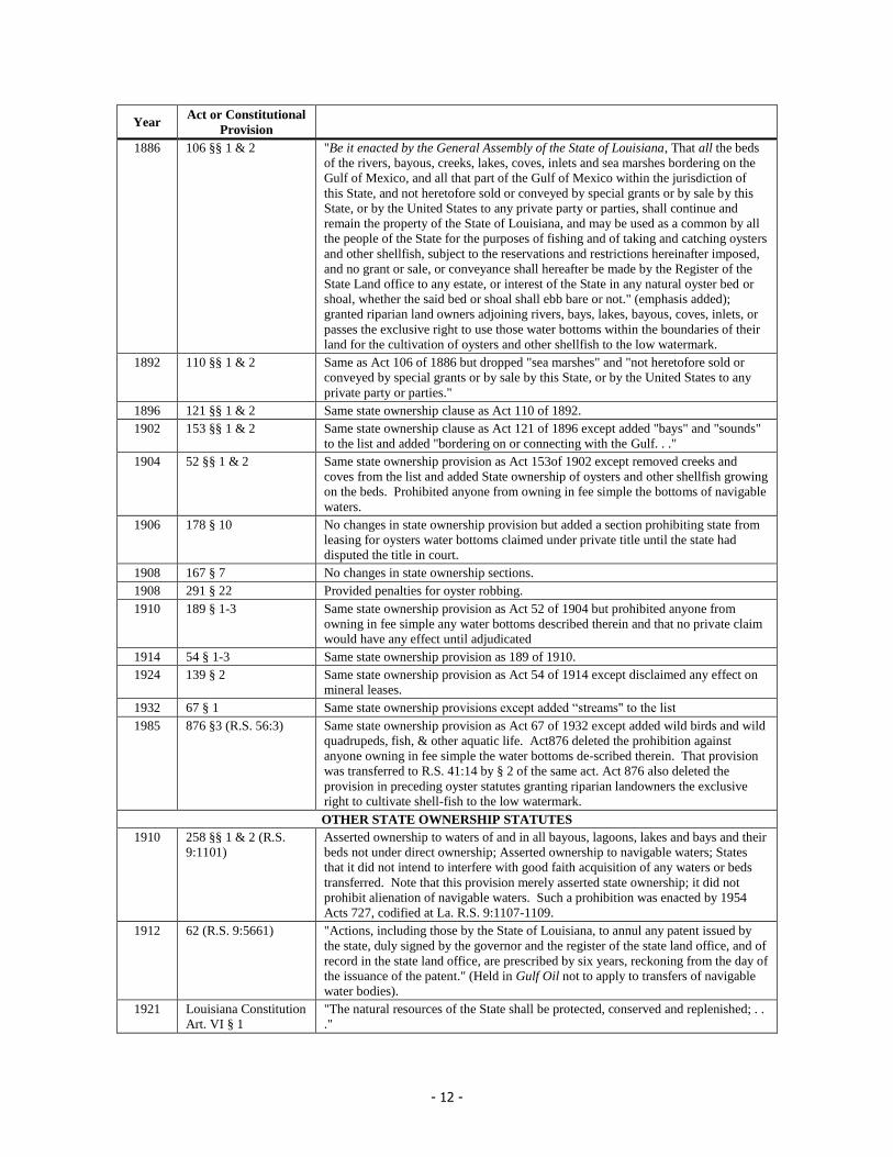
- 12 -
Year Act or Constitutional
Provision
1886 106 §§ 1 & 2 "Be it enacted by the General Assembly of the State of Louisiana, That all the beds
of the rivers, bayous, creeks, lakes, coves, inlets and sea marshes bordering on the
Gulf of Mexico, and all that part of the Gulf of Mexico within the jurisdiction of
this State, and not heretofore sold or conveyed by special grants or by sale by this
State, or by the United States to any private party or parties, shall continue and
remain the property of the State of Louisiana, and may be used as a common by all
the people of the State for the purposes of fishing and of taking and catching oysters
and other shellfish, subject to the reservations and restrictions hereinafter imposed,
and no grant or sale, or conveyance shall hereafter be made by the Register of the
State Land office to any estate, or interest of the State in any natural oyster bed or
shoal, whether the said bed or shoal shall ebb bare or not." (emphasis added);
granted riparian land owners adjoining rivers, bays, lakes, bayous, coves, inlets, or
passes the exclusive right to use those water bottoms within the boundaries of their
land for the cultivation of oysters and other shellfish to the low watermark.
1892 110 §§ 1 & 2 Same as Act 106 of 1886 but dropped "sea marshes" and "not heretofore sold or
conveyed by special grants or by sale by this State, or by the United States to any
private party or parties."
1896 121 §§ 1 & 2 Same state ownership clause as Act 110 of 1892.
1902 153 §§ 1 & 2 Same state ownership clause as Act 121 of 1896 except added "bays" and "sounds"
to the list and added "bordering on or connecting with the Gulf. . ."
1904 52 §§ 1 & 2 Same state ownership provision as Act 153of 1902 except removed creeks and
coves from the list and added State ownership of oysters and other shellfish growing
on the beds. Prohibited anyone from owning in fee simple the bottoms of navigable
waters.
1906 178 § 10 No changes in state ownership provision but added a section prohibiting state from
leasing for oysters water bottoms claimed under private title until the state had
disputed the title in court.
1908 167 § 7 No changes in state ownership sections.
1908 291 § 22 Provided penalties for oyster robbing.
1910 189 § 1-3 Same state ownership provision as Act 52 of 1904 but prohibited anyone from
owning in fee simple any water bottoms described therein and that no private claim
would have any effect until adjudicated
1914 54 § 1-3 Same state ownership provision as 189 of 1910.
1924 139 § 2 Same state ownership provision as Act 54 of 1914 except disclaimed any effect on
mineral leases.
1932 67 § 1 Same state ownership provisions except added “streams" to the list
1985 876 §3 (R.S. 56:3) Same state ownership provision as Act 67 of 1932 except added wild birds and wild
quadrupeds, fish, & other aquatic life. Act876 deleted the prohibition against
anyone owning in fee simple the water bottoms de-scribed therein. That provision
was transferred to R.S. 41:14 by § 2 of the same act. Act 876 also deleted the
provision in preceding oyster statutes granting riparian landowners the exclusive
right to cultivate shell-fish to the low watermark.
OTHER STATE OWNERSHIP STATUTES
1910 258 §§ 1 & 2 (R.S.
9:1101)
Asserted ownership to waters of and in all bayous, lagoons, lakes and bays and their
beds not under direct ownership; Asserted ownership to navigable waters; States
that it did not intend to interfere with good faith acquisition of any waters or beds
transferred. Note that this provision merely asserted state ownership; it did not
prohibit alienation of navigable waters. Such a prohibition was enacted by 1954
Acts 727, codified at La. R.S. 9:1107-1109.
1912 62 (R.S. 9:5661) "Actions, including those by the State of Louisiana, to annul any patent issued by
the state, duly signed by the governor and the register of the state land office, and of
record in the state land office, are prescribed by six years, reckoning from the day of
the issuance of the patent." (Held in Gulf Oil not to apply to transfers of navigable
water bodies).
1921 Louisiana Constitution
Art. VI § 1
"The natural resources of the State shall be protected, conserved and replenished; . .
."

- 13 -
Year Act or Constitutional
Provision
1921 Louisiana Constitution
Art. IV § 2
"Nor shall the Legislature alienate, or authorize the alienation of, the fee of the bed
of any navigable stream, lake or other body of water, except for purposes of
reclamation."
1938 55 (R.S. 49:3) Declared sovereignty of state and fixed sea-coast boundary and ownership by
declaring full and complete ownership of the "waters of the Gulf of Mexico and of
the arms of the Gulf and the beds and shores of the Gulf and the arms of the Gulf
including all lands that are covered by the waters of the Gulf and its arms either at
low tide or high tide, within the boundaries of Louisiana."
1952 341 (R.S. 9:1151) Commonly called the “Freeze Statute,” this act preserved mineral servitudes where
a change in ownership of land or waterbottoms occurs. As amended by broadened
terminology by Acts 2001, No. 963, the triggers for change in ownership were “as a
result of the action of a navigable stream, bay, lake, sea, or arm of the sea . . . or as a
result of accretion, dereliction, erosion, subsidence, or other condition resulting
from the action of a navigable stream, bay, lake, sea, or arm of the sea.”
1954 727 (R.S. 9:1107-
1109)
Stated it had always been the policy of the State that navigable waters and their beds
were public things and that no act of the legislature had been in contravention of
that policy; that Act 62 of 1912 (R.S. 9:5661)ratified only patents which had
conveyed land susceptible of private ownership which does not include navigable
water and their beds; that any patent purporting to alienate navigable waters was
null and void and that no statute shall be construed to validate the transfer of
navigable or tide waters or their beds (in R.S. 9:1109). (emphasis added)
1954 443 Amended 9:1101 to add clause rescinding and revoking purported conveyances of
navigable waters and their beds
1974 Louisiana Constitution
Art. IX § 1
"The natural resources of the state including air and water, and the healthful, scenic,
historic and aesthetic quality of the environment shall be protected, conserved and
replenished insofar as possible and consistent with the health safety and welfare of
the people. The Legislature shall enact laws to implement this policy"
1974 Louisiana Constitution
Art. IX § 3
"The Legislature shall neither alienate nor authorize the alienation of the bed of a
navigable water body except for purposes of reclamation by the riparian owner to
recover land lost through erosion."
1978 645 (R.S. 41:1701-
1714)
Proclaimed the beds and bottoms of all navigable waters and banks or shores of
bays, arms of the sea, the Gulf of Mexico and navigable lakes belong to the state
and are public lands to be protected and conserved for public navigation, fishery,
recreation, and other interests. Prohibits alienation (except for reclamation of lands
lost through erosion as authorized by this section) to ensure public interests
"protected by the trust"
1985 876 § 2 (R.S. 41:14) Prohibits alienation of “the bottoms of rivers, streams, bayous, lagoons, lakes, bays,
sounds, and inlets bordering on or connecting with the Gulf of Mexico . . . except
pursuant to R.S. 41:1701 through 1714” and states that "No one shall own in fee
simple any bottoms of lands covering the bottoms of waters described in this
section."
1992 998,§ 1 (R.S. 9:1115.1
– 1115.3(
Legislative declaration distinguishing Louisiana law from Phillips Petroleum Co. v.
Mississippi, 108 S.Ct. 791 (1988), and expressly rejecting the public trust doctrine
in that case. The Act stated that “the Phillips decision neither reinvests the state, or
a political subdivision thereof, with any ownership of such land nor does the state,
or a political subdivision thereof, acquire any new ownership of such property.”
However, the act preserved all existing public ownership. It defines “inland non-
navigable water bodies” and declares them to be private things (9:1115.2), and
creates a presumption that any conveyance by the state of a property includes
ownership of inland non-navigable water bottoms, unless the conveyance expressly
reserves such areas. (9:1115.3). The act includes a savings clause in 9:1115.3:
“Nothing contained in this Part shall be construed as conveying to any person title
to any land that have not previously been conveyed or transferred by the state.”
2001 963, § 1 Amended R.S. 9:1151 (the “Freeze Statute”) to broaden the types of waterbodies
covered by the statute, and to include erosion and subsidence as triggers of
ownership change.