2
L a n c a s h i r e W a l k s Parbold To be out of doors on a bright, clear day in April is one of life’s simple joys. All the dark days of winter are behind and the promise of spring and summer is set out before you. It hardly matters where you choose to go to see in the new season but who can resist the prospect of a bluebell wood besides a babbling brook. That is why this walk to the top of Parbold Hill is recommended as our walk of the month since it visits the exquisite Fairy Glen. A nice walk any other time of the year too! Start: Parbold Village Hall car park. From M6 exit at junction 27. Follow signs for A5209 to Parbold and Ormskirk. The village is approx 10 Km or 6 miles from exit. (You may be inclined to admire the view from the lay-by opposite the Wiggin Tree) After crossing railway and then canal turn right into village on Mill Lane, which leads into Station Road. The village hall is a short distance beyond a parade of shops. Distance: 12 Km or 7½ miles Time: 3 - 4 hours Terrain: Mainly easy walking with a moderate amount of effort required to ascend Fairy Glen. Map: OS Explorer 285 Southport & Chorley 1. Parbold Village to High Moor (6 Km or 3¾ miles:1½ - 2 hours) From car park walk back to the parade of shops turning left into Tan House Lane. At next T- junction turn right into Lancaster Lane. On meeting the A5209 turn right and then immediately left into Wood Lane, exercising proper care as you cross the road. Along Wood Lane views open to the south towards Ashurst Beacon. A stone sign marks the end of the metalled lane to put you on a farm track. (Pic 1) On reaching a metal gate, pass through a pair of kissing gates onto a public footpath. On a well way marked trail you will pass through patches of woodland and cross pastureland (Pic 2) to reach a stile leading into Fairy Glen. (Pic 3) Turn left and follow footpath beside Sprodley Brook through woodland up to the A5209. This local beauty spot is a very pleasant amenity, well maintained by the countryside service of the (West Lancashire) district council. (Pic 4) Turn right. After 200m cross the road and near the far end of the lay-by turn left onto a track. (Pic 5) In 100m the path divides. Bear right towards Boar’s Den Farm. On your right you will notice a distinctive hillock marked “Boar’s Den” on the OS map and is in fact an ancient barrow – or burial mound. Passing the farm turn left onto a track. This leads onto a path (Pic 6) which 500m (7½ mins) from the farm will bring you onto High Moor Lane. 2. High Moor to Parbold Village (6 km or 3¾ miles:1½ - 2 hs) Turn left on reaching the lane. After 100m turn right onto a drive just before High Moor Restaurant. After 500m when the drive swings left down to Harrock Hall keep ahead on a gently ascending footpath. (Pic 7) After passing through a patch of woodland turn right on a track leading upwards besides a meshed fence of a covered reservoir. Next to this arrangement is the triangulation column - the highest point of Parbold Hill at 157m (515ft in old money). (Pic 8) On a clear day the views are extensive. Retrace steps to the patch of woodland and keep ahead down to a stile. Continue on a clear path and at the next plantation dogleg right (Pics 9 & 10) around the wood to reach the ruins of the old windmill (Pic 11) that marks the top of Harrock Hill. At the mill turn left onto a footpath that leads (Pic 12) down through gorse towards a cluster of converted farm buildings. The right of way follows a drive down to Jackson’s Lane. Turn left onto Jackson’s Lane, which after a double bend will bring you onto Bannisters Lane. Turn left and begin to climb steeply again. Near the top of the brow turn right onto a footpath below Hunters Hill Quarry. (Pic 13) When the path meets a track turn right then immediately left onto a footpath that crosses two fields (Pic 14) to bring you onto Stony Lane. Turn right then in 100m turn left onto a footpath. The path soon begins a gentle descent to Parbold. After crossing a stile (Pic 15) continue to reach a footbridge which puts you in the adjoining field on the left. Follow the path as it skirts the field to enter a lane that brings you onto Lancaster Lane, close to the primary school. (Pic 16) Tann House Lane opposite will take you back to the village centre.

a s h ire W a L Parbold - LancashireWalks.com - … 100m turn right onto a drive just before High Moor Restaurant. After 500m when the drive swings left down to Harrock Hall keep ahead

  • Upload
    phambao

  • View
    213

  • Download
    0

Embed Size (px)

Citation preview

Lan

cashire WalksParbold

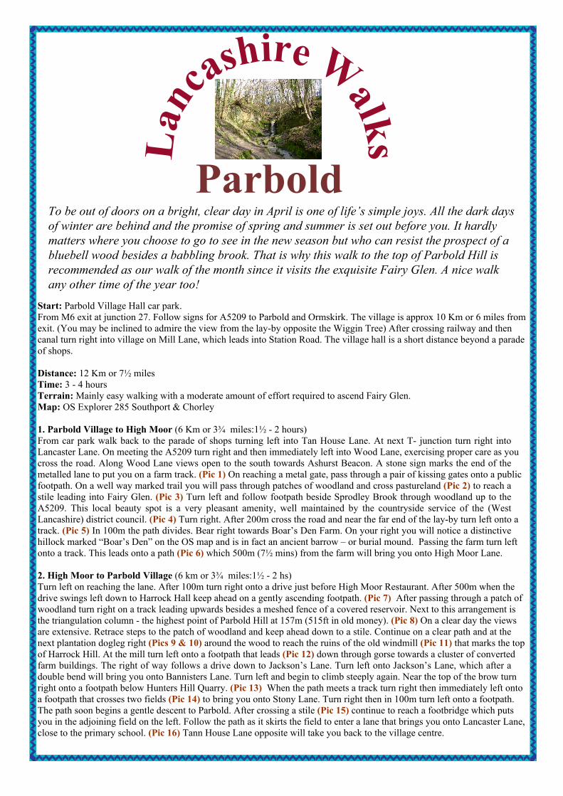
To be out of doors on a bright, clear day in April is one of life’s simple joys. All the dark daysof winter are behind and the promise of spring and summer is set out before you. It hardlymatters where you choose to go to see in the new season but who can resist the prospect of abluebell wood besides a babbling brook. That is why this walk to the top of Parbold Hill isrecommended as our walk of the month since it visits the exquisite Fairy Glen. A nice walkany other time of the year too!

Start: Parbold Village Hall car park.From M6 exit at junction 27. Follow signs for A5209 to Parbold and Ormskirk. The village is approx 10 Km or 6 miles fromexit. (You may be inclined to admire the view from the lay-by opposite the Wiggin Tree) After crossing railway and thencanal turn right into village on Mill Lane, which leads into Station Road. The village hall is a short distance beyond a paradeof shops.

Distance: 12 Km or 7½ milesTime: 3 - 4 hoursTerrain: Mainly easy walking with a moderate amount of effort required to ascend Fairy Glen.Map: OS Explorer 285 Southport & Chorley

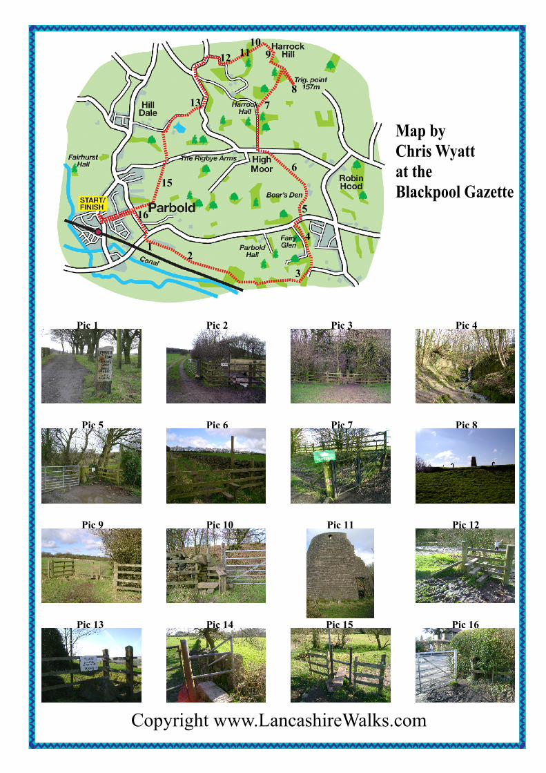
1. Parbold Village to High Moor (6 Km or 3¾ miles:1½ - 2 hours)From car park walk back to the parade of shops turning left into Tan House Lane. At next T- junction turn right intoLancaster Lane. On meeting the A5209 turn right and then immediately left into Wood Lane, exercising proper care as youcross the road. Along Wood Lane views open to the south towards Ashurst Beacon. A stone sign marks the end of themetalled lane to put you on a farm track. (Pic 1) On reaching a metal gate, pass through a pair of kissing gates onto a publicfootpath. On a well way marked trail you will pass through patches of woodland and cross pastureland (Pic 2) to reach astile leading into Fairy Glen. (Pic 3) Turn left and follow footpath beside Sprodley Brook through woodland up to theA5209. This local beauty spot is a very pleasant amenity, well maintained by the countryside service of the (WestLancashire) district council. (Pic 4) Turn right. After 200m cross the road and near the far end of the lay-by turn left onto atrack. (Pic 5) In 100m the path divides. Bear right towards Boar’s Den Farm. On your right you will notice a distinctivehillock marked “Boar’s Den” on the OS map and is in fact an ancient barrow – or burial mound. Passing the farm turn leftonto a track. This leads onto a path (Pic 6) which 500m (7½ mins) from the farm will bring you onto High Moor Lane.

2. High Moor to Parbold Village (6 km or 3¾ miles:1½ - 2 hs)Turn left on reaching the lane. After 100m turn right onto a drive just before High Moor Restaurant. After 500m when thedrive swings left down to Harrock Hall keep ahead on a gently ascending footpath. (Pic 7) After passing through a patch ofwoodland turn right on a track leading upwards besides a meshed fence of a covered reservoir. Next to this arrangement isthe triangulation column - the highest point of Parbold Hill at 157m (515ft in old money). (Pic 8) On a clear day the viewsare extensive. Retrace steps to the patch of woodland and keep ahead down to a stile. Continue on a clear path and at thenext plantation dogleg right (Pics 9 & 10) around the wood to reach the ruins of the old windmill (Pic 11) that marks the topof Harrock Hill. At the mill turn left onto a footpath that leads (Pic 12) down through gorse towards a cluster of convertedfarm buildings. The right of way follows a drive down to Jackson’s Lane. Turn left onto Jackson’s Lane, which after adouble bend will bring you onto Bannisters Lane. Turn left and begin to climb steeply again. Near the top of the brow turnright onto a footpath below Hunters Hill Quarry. (Pic 13) When the path meets a track turn right then immediately left ontoa footpath that crosses two fields (Pic 14) to bring you onto Stony Lane. Turn right then in 100m turn left onto a footpath.The path soon begins a gentle descent to Parbold. After crossing a stile (Pic 15) continue to reach a footbridge which putsyou in the adjoining field on the left. Follow the path as it skirts the field to enter a lane that brings you onto Lancaster Lane,close to the primary school. (Pic 16) Tann House Lane opposite will take you back to the village centre.

Copyright www.LancashireWalks.com

Pic 1 Pic 2 Pic 3

Pic 5 Pic 6 Pic 7

Pic 9 Pic 10 Pic 11

Pic 13 Pic 14 Pic 15 Pic 16

Pic 4

Pic 8

Pic 12

Map byChris Wyattat theBlackpool Gazette

12

3

4

5

6

78

910

1112

13

15

16