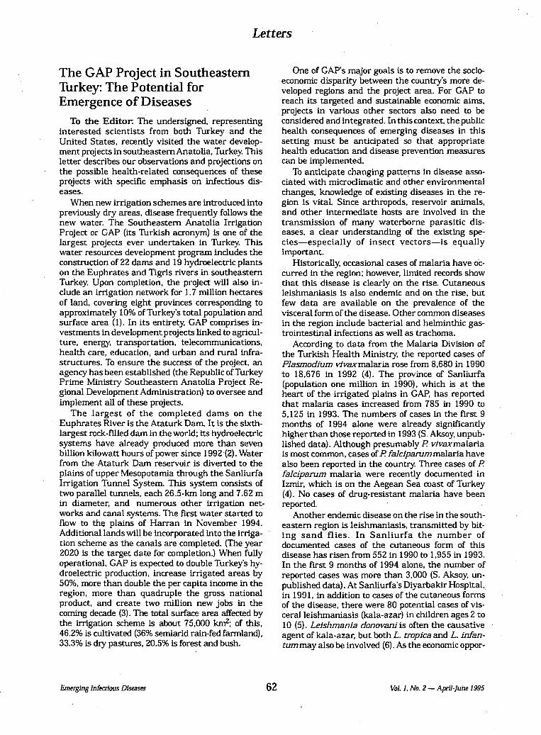
Embed Size (px)
Citation preview

A REVIEW OF THE HYDROLOGIC AND GEOMORPHIC IMPACTS
OF THE PROPOSED ILISU DAM
Commissioned by World Economy, Ecology and Development (WEED)
on behalf of the European Ilisu Campaign:
Berne Declaration Eca-Watch-Austria
Forests and the European Union Resource Network (FERN) Kurdish Human Rights Project (KHRP)
The Corner House WEED
Prepared by Philip B. Williams, Ph.D., P.E., Eur. Ing.
Setenay Bozkurt Frucht, M.S.
Philip Williams & Associates, Ltd.
February 20, 2006 PWA Ref. # 06-006

1
TABLE OF CONTENTS
Page No.
1. INTRODUCTION 2
2. CONCLUSIONS 4
3. SETTING 7
4. HYDROLOGIC IMPACTS 10
5. GEOMORPHIC IMPACTS 14
6. WATER QUALITY IMPACTS 16
7. ENVIRONMENTAL IMPACTS OF PHYSICAL CHANGES 18
8. ADEQUACY OF THE ILISU DAM UEIAR 20 LIST OF FIGURES Figure 1. Map of the Tigris and Euphrates Watersheds 8 Figure 2. Changes in Seasonal Flows Crossing the Border due to Cizre Irrigation 11 Figure 3. Attenuation of Daily Flow Fluctuations at the Syrian Border 12 Figure 4. Changes in Inflows to Ilisu due to GAP Irrigation Projects Upstream 13 Figure 5. Sedimentation Analysis of Turkish Reservoirs LIST OF APPENDICES
APPENDIX A. Estimates of Flow Changes
APPENDIX B. The press release by VA Tech Hydro on November 26, 2005
APPENDIX C. Correspondence with the IEG
APPENDIX D. List of source documents provided by the Ilisu Consortium
APPENDIX E. Emerging Infectious Diseases in the GAP region

2
1. INTRODUCTION
The companies of the Ilisu Consortium have been seeking export credit support from a number of European countries in order to participate in the construction of the proposed Ilisu Dam in southeastern Turkey. Before granting such credits, the governments concerned require a full consideration of the environmental consequences of constructing and operating the dam. In response to this requirement, the Ilisu Consortium1 contracted with the Ilisu Environment Group (IEG)2 to update the previous environmental impact assessment report (EIAR, 2001) in accordance with World Bank guidelines and produced the current UEIAR (2005). In 1993, the Government of Turkey adopted Environmental Impact Assessment Regulations but specifically excluded projects, like the Ilisu dam, whose final design had been previously approved [p1-18]. The UEIAR has been circulated for public comments. The UEIAR is an updated version of the previous EIAR, which was prepared according to Exim-Bank guidelines. In addition to revising the report based on modified guidelines, the UEIAR incorporates new information that was made available since the EIAR of 2001. The purpose of the UEIAR is described as “to allow full consideration of the environmental impact of the project by the Turkish authorities as well as by the relevant international financing institutions” [p1-3]. The IEG acknowledges that because the design and operational plan of the Ilisu Dam was developed before 1993 when Turkish environmental regulations went into effect, without integrating environmental considerations, the IEG cannot ensure that the UEIAR complies with contemporary international standards [p1-18] Worldwide, large dam building technology is relatively new and in the last 20 years has produced a substantial amount of new research and practical experience concerning the impact of large dams on major river systems. In many instances unanticipated environmental impacts have adversely affected or even frustrated the original economic development goals of the project (WCD 2000). Because of the importance of the possible large scale hydrologic, geomorphic and water quality impacts of the dam on the Tigris River system, PWA Ltd. has been contracted by The World Economy, Ecology, and Development to update its previous review of the 2001 EIAR prepared for The Corner House (PWA, 2001). This updated review evaluates the potential physical effects of the Ilisu Dam and assesses whether the UEIAR published by the IEG adequately describes these impacts. PWA was requested to summarize its findings in this report to be completed in time to be submitted to relevant government agencies during the formal public comment period by February 20, 2006.
2 The UEIAR states that the Ilisu Consortium is composed of Sulzer Hydro AG, ABB, and civil construction companies to be approved by the General Directorate of Hydraulic Works (DSI) and the Union Bank of Switzerland. However, the official web site of the project (http://www.ilisu-wasserkraftwerk.com) identifies VA Tech Hydro, Alstom, Nurol, Cengiz, Celiker, Zueblin, Stucky, and Temelsu as the Consortium companies. 2 The IEG is composed of Hydro Concepts Engineering, Hydro-Quebec International, and Archeotec Inc.

3
In carrying out this review, the Ilisu Consortium provided PWA with several of the important source documents of the original feasibility study (Appendix E). We relied on the UEIAR itself and on published articles as the primary source of our data. Except as noted for the purpose of this review, we have assumed hydrologic and engineering data presented to be accurate but have not carried out independent checks.

4
2. CONCLUSIONS 1. The Ilisu Dam is a major component of an integrated water development scheme planned in the
1970’s for the upper Tigris watershed. The goal of this scheme is to provide economic development within the region through the generation of electricity and large scale irrigated agriculture. While the UEIAR states that the Dam is “a pure energy project” [p2-27] and “a single purpose hydroelectric facility” [p2-28] it will also ‘increase the water available for irrigation’ [p4-20] by storing seasonal runoff that will be released and then diverted from the river downstream at the planned Cizre Dam. Diversions from Cizre are planned to irrigate approximately 121,000 ha [p2-26].
2. The construction and operation of the Ilisu Dam by itself, will significantly affect the hydrology of the Tigris River. It will alter the seasonal flow pattern by capturing all except large flood flows in the spring and releasing them in the fall and it will create large daily flow fluctuations whose influence would be felt more than 65 km downstream at the Syrian border.
3. The UEAIR does not include any specific commitment to maintain a minimum flow level downstream. However, it does recommend an operational policy be adopted to release a minimum monthly average flow of 60 m3/s at the downstream border during operation of the dam [p4-18].
4. There appears to be a discrepancy between the Executive Summary and the main text of the UEAIR with regards to minimum flows. In the Executive Summary, the minimum flow recommendation is presented as if it already is an adopted policy [pEXE-19]. However, in the main text of the report, this is represented as a “recommended objective” [p4-18].
5. The analysis and information presented in the UEIAR conflicts with a statement in a press release on November 26, 2005 by VA Tech Hydro (Appendix B), one of the current Ilisu Consortium companies. The press release stated that General Directorate of Turkish Hydraulic Works (DSI) is committed to increase the monthly average minimum flows from 60 m3/s to 100 m3/s. If true, this increase in minimum flows would reduce energy generation and change the reservoir operation.
6. The operation of the Ilisu Dam in combination with diversions from the future downstream Cizre project would probably significantly reduce summer flows in Syria and Iraq below historic levels. It is likely that a significant portion of the recommended minimum flow release from Ilisu of 60 m3/s during dry years would be diverted. It is even possible that with full implementation of the Ilisu/Cizre projects, during drought periods, all the summer flows could be diverted before it crossed the border.
7. Future depletions of the Tigris river flows for planned irrigated agriculture both upstream and downstream of Ilisu would further reduce these flows. Although the UEIAR acknowledges this future reduction, it significantly underestimates and appears to miscalculate the potential flow reduction at the border [Encl.1, p18].

5
8. The Ilisu reservoir would eliminate small to moderate flood peaks downstream but would not significantly reduce extreme large flood peaks.
9. The UEIAR acknowledges that the peaking power reservoir releases will cause river level fluctuations of up to 7 meters in a few hours destabilizing river banks up to 50 kilometers [Encl.1, p38 and p60].
10. There are large uncertainties in estimates of reservoir sedimentation. A new method now cited in the UEIAR appears to differ significantly from suspended sediment yield estimates based on long-term gauge measurements. These measurements indicate sediment delivery of up to six times the revised estimate presented [p3-11; EIAR (2001) p4-50] and pose the risk of significantly underestimating the actual reduction in reservoir lifetime.
11. It is possible that with future deteriorating watershed conditions active reservoir storage losses would be in the range of 0.1 to 1 percent per year based on gauge measurements and previous estimates. This could adversely affect power generation within a few decades.
12. Deposition of coarse sediments in the mouths of rivers discharging to the reservoir will cause increased flood levels, waterlogging, and increased channel migration along tributary rivers upstream.
13. Capturing of coarse sediment in the reservoir will tend to induce scouring of the river channel downstream, lowering the river level and possibly lowering the adjacent water table as well.
14. The UEIAR acknowledges that reservoir level fluctuations will expose reservoir bed. However, the extent of the potential impact in dry years is underestimated. The UEIAR implies that maximum drawdown in dry years would not exceed 25 meters in a 100 years exposing approximately 120 km2. [Encl.1, p33, EIAR (2001) p4-12]. However, in the event of repeat of an actual drought similar to 1988 to 1990, the operation plan, which has not changed since 2001, would lower the reservoir 35 meters, exposing approximately 150 km2 [Encl.1, p33, EIAR (2001) p4-12 and p4-43].
15. High levels of nutrients from sewage and agricultural runoff will cause eutrophication and anoxic conditions in the reservoir [pEXE-10]. The constructed and planned sewage treatment plants will not significantly reduce these levels [p4-39, p4-42].
16. Anoxic conditions will likely generate significantly higher levels of greenhouse gas methane emissions than occur from the existing landscape and will probably mobilize heavy metals from reservoir sediments.
17. Discharges from the reservoir will be anoxic and likely to contain high levels of nutrients, organic matter and hydrogen sulphide (H2S). Pollution and eutrophication of the reservoir could create public health hazards for people drinking water or eating fish caught in the reservoir.
18. Downstream water supply in Syria and Iraq could be significantly affected by both reduction in summer flows and deterioration in water quality.

6
19. There could be a significant increase in flood hazards downstream. The elimination of smaller floods will encourage the development of floodplain and river channel land; however these areas will still be subject to extreme flood events.
20. The consequences of failure of the dam due to accident or act of war would be catastrophic affecting millions of people living downstream.
21. Summer exposure of large areas of reservoir bed, as well as aggrading river channels upstream, will provide a major habitat for disease vectors such as malaria etc [p4-125].
22. We do not find key conclusions presented in the UEIAR to be justified, in some instances because they are unsubstantiated, in others the information on which they are based is contradictory, incomplete, of unknown accuracy, or inappropriate level of analysis.
23. We find the methodology or logic of the UEIAR to be seriously flawed because the Project definition is unclear, cumulative impacts were not addressed, trans-border impacts were ignored, and impacts were not analyzed over the lifecycle of the project.
24. It appears that key decisions on the Ilisu dam and operational design were made 25 years ago without integrating environmental planning, as is now the established practice. Instead the UEIAR attempts to analyze the consequences of decisions already taken and suggest mitigation actions that are not part of the project, which might be taken to reduce adverse impacts.
25. On many important issues the UEIAR does not present an impartial assessment but instead seeks to minimize the significance of adverse impacts or argue that they will be mitigated.
26. It does not appear that the proponents of the Ilisu dam have completed the kind of technical studies reasonably expected to evaluate environmental impacts for a major project of this type that should include hydraulic modeling, reservoir water quality modeling, river and reservoir sedimentation modeling, and dam break analysis.

7
3. SETTING
The Tigris River is the second largest river in southwest Asia (1,840 km). It is an international river shared by Turkey, Iraq, and Iran, with Syria as a minor riparian. Parallel to its twin sister the Euphrates, it flows through one of the most arid regions of the world, and is relied on by an increasing number of people for agriculture, urbanization and industrialization. Within the last three decades both Turkey and Iraq have started to implement ambitious water development schemes that are transforming the river, and the lives of people who depend on it. Downstream of Turkey, Iraq is extremely dependent on the Euphrates and Tigris Rivers as its only sources of water. There are several multi-purpose water development projects along Tigris in Iraq. The large multi-purpose Mosul Dam with a reservoir capacity of 11 billion m3 was completed in the late 80’s. The Sennacherib Dam with a reservoir capacity of 10 billion m3 is currently under construction. The Sammarra Barrage upstream of Baghdad diverts water from the Tigris River into the Thartar depression to protect Baghdad against flooding. At flood stage, the total storage of the depression is 85,000 Mm3.The Mosul Dam, combined with massive drainage works constructed after the Gulf war, has resulted in the transformation of the lower Tigris River and the destruction of the unique Mesopotamian marshland ecosystem, displacing the indigenous Marsh Arabs (EOS 2001). The Turkish government is seeking to exploit the upper part of the Tigris River as part of its Southeastern Anatolia Project (GAP). The GAP is intended to be an integrated regional development plan covering a wide array of sectors such as irrigation, hydraulic energy production, agriculture, urban and rural infrastructure, forestry, education and health (http://www.gap.gov.tr). Its closest conceptual analogues are the American Tennessee Valley Authority planned in the 1930’s or the Mekong Valley Scheme, planned in the 1960’s (Kolars and Mitchell 1991). The GAP project area covers about 10 percent of Turkey, and according to the 2000 census approximately 9.7 percent of Turkey’s population lives within the area being developed by the GAP. The water resources program of the GAP envisages the construction of 22 dams and 19 power plants and irrigation schemes on an area extending over 1.7 million hectares. The total cost of the GAP project is 32 billion US$, with energy and agricultural projects having a share of 36 and 34 percent, respectively [p2-4] (http://www.gap.gov.tr). The Ilisu Dam and Hydroelectric Power Plant is the centerpiece of the GAP development plan for the Tigris River. It is a 135 m high rockfill dam located 65 km upstream of the Syrian border and will create a reservoir with a live storage volume of 7460 million m3 [p2-28], extending 136 km up the Tigris valley [p2-29]. The power station will have a capacity of 1,200 MW and is expected to produce 3,800 GWh of power per year [p2-27]. Ilisu has a large active storage area that compensates the highly variable seasonal and annual flow fluctuations in order to generate electricity throughout the year. It is designed as a peaking power plant that will operate to meet the daily and seasonal peak energy needs. Ilisu is therefore planned to operate in conjunction with the Cizre Dam to be constructed 45 km downstream. Cizre will act as a re-regulating reservoir to even out the highly variable peaking power releases (‘to better regulate the discharges downstream of Ilisu” [p2-10]), and provide for diversion of water to irrigate 121,000 ha of arid lands [p2-3].

8
Currently, also as part of GAP, there are twelve projects in operation or under construction in the Tigris Basin, of which eleven are upstream of Ilisu [p2-26]. These upstream projects cover around 138,000 ha of irrigation land [Encl.1, p18]. In addition, there are six projects that are in reconnaissance, planning, or at Master Plan stage covering approximately 375,000 ha of land to be irrigated. These upstream projects will result in significant reductions in the river flow before reaching Ilisu. All the irrigation projects upstream and downstream of Ilisu cover a total of approximately 637,000 ha. In Turkey, the Tigris flows in the southeast for about 400 km, forms the border with Syria for 40 km, and flows downstream to Iraq. The main stem of the Tigris drains an area of 41,000 km2 in Turkey [pEXE-2]. The flow is characterized by a high annual and seasonal variability. The annual mean flow is 520 m3/s at the border (16.2 billion m3) [p2-28]. The lowest flow was 9.6 billion m3 in 1973, and the highest was 34.3 billion m3 in 1969 [p2-28]. Maximum runoff events spread between November and May. Mean flow in April is 1400 m3/s, while the driest month September is 115 m3/s [p3-10]. Downstream, at Baghdad, the average flow is 1236 m3/s (Kliot 1994).

9

10
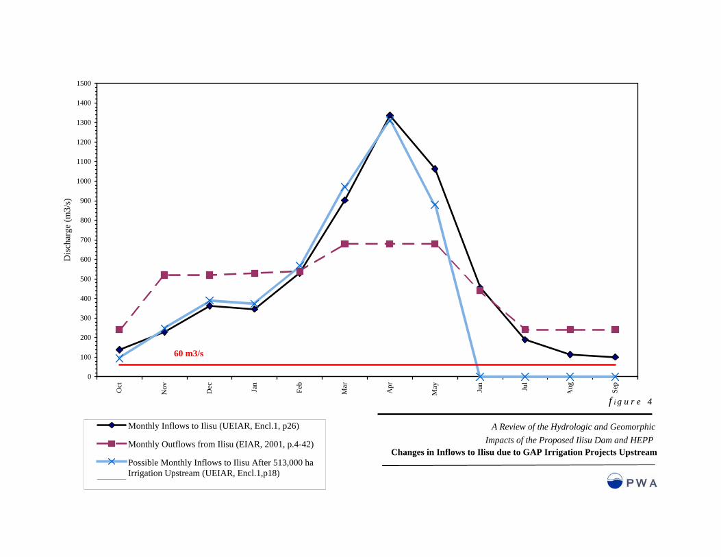
4. HYDROLOGIC IMPACTS The operation of the Ilisu reservoir will substantially alter the flow regime of the Tigris River downstream. In order to generate electricity throughout the year and maximize the potential irrigation diversion downstream, the dam will be operated to store high flows in the spring, make constant releases in the summer growing season, then increase releases to meet higher winter electricity demand. The net effect on flows crossing the border into Syria and Iraq, prior to the completion of the Cizre diversion downstream, is increased flows in the river in the summer, fall and winter [p4-16, EIAR (2001) p4-42], and reduced flows in the spring. After completion of the Cizre diversion summer flows would be substantially reduced by irrigation diversions and would probably be reduced below pre-project conditions. Although this significant impact was not addressed in the UEIAR, it can be illustrated by subtracting expected irrigation diversions to supply the 121,000ha of the Cizre project from what is represented as the average year flow regime presented in the UEIAR. Based on estimated consumptive use of 1.6 m (Kolars and Mitchell 1991) approximately 12 percent of the annual flow would be utilized. Figure 2 and Appendix A show how average monthly cross border flows would likely be substantially reduced when the combined Ilisu/Cizre project is implemented. Water users downstream would be most impacted by the reduction in flow frequency –and hence irrigation reliability- as much as the change in average monthly flow rate. Because the full operational simulation of the reservoir was not presented in the UEIAR, it is not possible to quantify the increase in frequency of low flows crossing the border. However, because minimum releases from Ilisu during extreme droughts have not been confirmed, and even if they were limited to 60 m3/s, it is possible that during drought periods, with full implementation of the Ilisu/Cizre project all the summer flow could be diverted before it crossed the border. The reliability of flows crossing the border would be further reduced in the future by the cumulative impacts of additional diversions and other components of the GAP scheme, as they are implemented. Approximately 140,000 ha of irrigated land is in use or in implementation, and another 375,000 ha is planned in the catchment area above the Ilisu reservoir [p2-26, Table 6, Encl.1, p18p4-28]. The analysis in the UEIAR contains an error and underestimates the extent of potential flow reductions due to upstream irrigation requirements. This analysis miscalculated the planned irrigation area upstream of Ilisu by approximately 35 percent [Table 6, Encl.1, p18]. In addition, the UEIAR significantly underestimates the consumptive use for the irrigation area upstream of the dam, assuming it to be only 0.85 m of applied water per year [Table 6, Encl.1, p18p4-28] instead of approximately 1.6 m or more typically experienced in semi arid climates and estimated by independent analysis for the GAP area (Kolars and Mitchell 1991). This more conventional estimate of consumptive use would reduce annual flows at Cizre up to 40 percent if all upstream and downstream projects were implemented (Figure 4 and Appendix A). This future flow reduction could significantly affect the Ilisu reservoir operation resulting in reduced generation in dry years or greater drawdown of reservoir levels in average years exposing more than 120 km2 of reservoir floor.

0
100
200
300
400
500
600
700
800
900
1000
1100
1200
1300
1400
1500
Oct
Nov Dec Jan
Feb
Mar
Apr
May Jun
Jul
Aug Sep
Dis
char
ge (m
3/s)
Monthly Inflows to Ilisu (UEIAR, Encl.1, p26)
Monthly Outflows from Ilisu (EIAR, 2001, p.4-42)
Flows at the Border After Cizre Irrigation Diversions of121,000 haSeries3
f i g u r e 2
A Review of the Hydrologic and Geomorphic Impacts of the Proposed Ilisu Dam and HEPP
Average Monthly Flows of Tigris at the Border After Cizre Irrigation Use
60 m3/s

11
During the operation of Ilisu, the UEIAR recommends that discharges downstream be maintained at a minimum flow release of 60 m3/s during summer and fall. A monthly minimum flow of 60m3/s could mean significantly lower daily average flows. If adopted this would create unprecedented low flow conditions downstream more extreme than the worst historic drought. Although the UEIAR did not present this information, the effect can be seen by comparing natural flows with planned releases (Figures 2 and 4). The outflows from the reservoir were obtained from the previous EIAR [EIAR, p4-20 and 4-42] because the UEIAR did not present this information and has not updated the operation of the reservoir. The selection of average monthly flow of 60 m3/s as the minimum flow release was based on the historic lowest monthly recorded flow at Cizre in September 1960, rather than the minimum of all months in the growing season. It is important to note that since 1960 water use downstream has increased significantly. In the interim period between completion of Ilisu and completion of Cizre the daily peaking power releases from Ilisu will significantly affect flows downstream. Discharges will change from 4.9 to 1200 m3/sec in a few hours [p4-24] (In comparison, this flow variation approximates the maximum flood and minimum drought flow recorded on the River Thames at Kingston in the period 1883 to 2000). The UEIAR acknowledges that this discharge variation will have negative environmental impacts on the downstream riverbed morphology and fauna/flora/ecosystem [p4-17] and carried out a simple analysis that showed fluctuations of up to 7 m at Cizre [Encl.1, p38]. Based on a simple dynamic flood routing analysis assuming a typical river channel shape of the Tigris between Ilisu and the Mosul Dam about 160 km downstream, the daily flood surge might only be 16 percent attenuated where it crossed the border (Figure 3). Although the Ilisu reservoir operation described in the UEIAR will result in the capture of the relatively frequent small to midsize floods, it will not control the infrequent large damaging floods. Although the UEIAR states “floods will still occur but with attenuated peaks and with reduced return frequencies” [p4-16], it does not present any analysis of the change in flood frequency due to the project. The Ilisu dam will be operated to maximize power generation revenues and provide a reliable irrigation supply – not for flood control. Large floods, such as the 100-year frequency event cited in the UEIAR that has a peak inflow of 11,500 m3/sec [p3-10], would completely fill the reservoir prior to the arrival of the flood crest. The reservoir therefore would not attenuate such a flood event.

13
0
200
400
600
800
1000
1200
1400
1600
0.00 10.00 20.00 30.00 40.00 50.00 60.00 70.00
Time (hours)
Dis
char
ge (m
3/s)
Daily Winter Releases From Ilisu (UEIAR, Encl.1, p57)
Flow at the border (Manning's n=0.04 from UEIAR p 3-15)
A Review of the Hydrologic and Geomorphic Impacts of the Proposed Ilisu Dam and HEPP
Attenuation of daily flow fluctuations at the Syrian border
f i g u r e 3
The above graph shows the attenuation at the border of daily winter releases from Ilisu, assuming the same winter release schemes as Ataturk Dam (UEIAR, Encl.1, p 57). The simulation was modeled using one-dimensional hydrodynamic model MIKE-11. The model parameters were obtained from the EIAR and published articles on the Tigris. A roughness coefficient (Manning’s n) of 0.04 was used for the channel. Due to lack of data on channel geometry in Turkey, a typical channel cross section downstream of the Mosul Dam in Iraq was used as a surrogate cross section downstream of Ilisu (see Al-Ansari and Rimawi 1997 for channel surveys).
0
100
200
300
400
500
600
700
800
900
1000
1100
1200
1300
1400
1500
Oct
Nov Dec Jan
Feb
Mar
Apr
May Jun
Jul
Aug Sep
Dis
char
ge (m
3/s)
Monthly Inflows to Ilisu (UEIAR, Encl.1, p26)
Monthly Outflows from Ilisu (EIAR, 2001, p.4-42)
Possible Monthly Inflows to Ilisu After 513,000 haIrrigation Upstream (UEIAR, Encl.1,p18) Series3
f i g u r e 4
A Review of the Hydrologic and Geomorphic Impacts of the Proposed Ilisu Dam and HEPP
Changes in Inflows to Ilisu due to GAP Irrigation Projects Upstream
60 m3/s

14
5. GEOMORPHIC IMPACTS The Tigris River conveys large amounts of boulders, sand and mud eroded from the mountain slopes of its catchment. The creation of a large reservoir will capture almost all of this sediment, progressively filling the storage volume and eventually converting it to a marshy alluvial plain. The UEIAR presents two significantly different sediment yield estimates: first based on historic records along Tigris, and second based on an analysis of records from 17 gauging stations upstream of reservoirs throughout Turkey. The gauging stations at Rezuk and Cizre are in the vicinity of Ilisu dam site and have suspended sediment records. Based on these records, the average sediment inflow to Ilisu would be 15 to 30 million m3/year [p3-11]. The UEIAR presents an alternative estimate of sediment yield at the Ilisu site based on an empirical study on sediment yields to reservoirs in Turkey (Gogus and Yener, 1997). This study analyzed 17 gauging stations upstream of Turkish reservoirs to develop a formula to estimate sediment yield based on drainage area, precipitation, discharge, and soil characteristics. The sediment yields at the Rezuk and Cizre stations based on this analysis would be between 4.5 and 5 million m3/year. These estimates are between one third and one sixth of the actual records and of the estimates used in the previous EIAR of 2001 [p4-50]. The original feasibility study (Ilisu Hydropower Consultants, 1977) cites a sediment yield on the order of 20 million m3/year. This is a significant reduction in the estimation of sediment yield to the reservoir. However, there are no comparisons of sediment yields obtained based on these two methods, nor is there any justification to use the empirical analysis instead of the actual recorded data. There are substantial uncertainties in any sediment delivery analysis. Figure 5 illustrates this by showing that the scatter in the data used in this empirical analysis is at least an order of magnitude. The uncertainty involved in this analysis can be illustrated with another example. In an adjacent watershed in Iran, reservoir sedimentation rate is observed to be approximately 50 million m3/year (Morris and Fan, 1998). The Gogus and Yener (1997) formula would have predicted a sedimentation yield estimate of 8 million m3/year. Even the higher sediment yield appears to be underestimating the total sediment. Where watersheds are disturbed by development, erosion rates in semi arid areas can increase significantly –sometimes by two or three orders of magnitude (Newson 1997). Worldwide, there have been many instances where reservoir sedimentation rates have been greatly underestimated –and the importance of this experience has not been discussed in the UEIAR. Earlier analysis by the World Bank of this problem indicates that sediment yield for the size of tributary watersheds flowing into the Ilisu reservoir could be in the range 1000 to 10000 tons/km2 (Mahmood 1987, p. 27, Fig 3-1). This would indicate rates of loss of live storage of the order of 0.1 to 1 percent per year. At this higher rate of sedimentation, power production and irrigation deliveries would be significantly impaired within 30 years of the start of reservoir operation. The size distribution of the suspended sediment records indicates that there is a high proportion of sand of 30 percent [p3.15]. Sand size materials tend to settle out quickly once it reaches the stagnant water of the reservoir. The UEIAR states that a part of these sediments will be transported downstream during the powerplant operation. However, the water drawn off through the power station will be clear, and therefore the waters leaving the reservoir during regular operation will be mostly sediment free.

y = 2.1441x0.9414
R2 = 0.8183
1,000
10,000
100,000
1,000,000
10,000,000
100,000,000
1,00
0
10,0
00
100,
000
1,00
0,00
0
10,0
00,0
00
100,
000,
000
Observed Sediment (m3/year)
Est
imat
ed se
dim
ent (
m3/
year
)
f i g u r e 5
A Review of the Hydrologic and Geomorphic Impacts of the Proposed Ilisu Dam and HEPP
Sedimentation Analysis of Turkish Reservoirs (after Gogus and Yener, 1997)
Notes:Data used in the reservoir sedimentation study from UEIAR, p3-12.
Ilisu estimates

15
The Ilisu Dam is designed to capture accumulating sediment in the lowest part of the reservoir dedicated as inactive or “dead” storage. This amounts to about 30 percent of the total 10,410 Mm3 reservoir volume [p2-35]. The EIAR does not present a simulation of reservoir sedimentation. It might be inferred that it would take more than 500 years using the Gogus and Yener formula, and between 100 to 200 years using actual gauge data before the active storage starts to fill. This inference would be mistaken and it is likely that from the beginning of operation, there would be some progressive filling of the active storage as well due to deposition of sand deltas at the mouths of tributary rivers. For the sediment yield of 15 to 30 million m3/year based on the gauge data, this filling would be of the order of 0.1 percent per year, assuming about 30 percent of the inflowing sediment is deposited in the shallower arms of the reservoir. As sand and boulders accumulate at the mouths of the tributary rivers, they accentuate backwater effects from the reservoir, causing progressive deposition of bed load in the river channel upstream. As the bed level increases, flooding and erosion of floodplains occur and this process of riverbed aggradation will continue upstream until the reservoir has silted in and the river channel can reach equilibrium. Depending on the river slope, these effects can propagate tens of kilometers upstream. (In an extreme case on the Yellow River backwater sedimentation extended 250 km upstream (Morris and Fan, 1998)). Unfortunately, the UEIAR only anecdotally describes this impact [p4-34] – even though predictive sediment transport models are available to simulate this change and identify the extent of impact upstream. Within the reservoir, wind wave action and fluctuating reservoir level will erode the reservoir edge. Although the UEIAR references this problem [p4-14] it does not indicate its extent. Downstream of the dam the river channel will undergo significant changes – until it is submerged by the Cizre reservoir. Large reservoirs without low-level outlets will typically trap more than 90 percent, and sometimes almost 100 percent, of incoming sediment (Morris and Fan, 1998). The clear flows discharging from the Ilisu dam will seek to recapture its sediment load by scouring the channel bed. This would cause lowering of the channel and erosion of channel banks. Riverbeds are typically eroded by several meters within the first decade of a new dam. For instance, within nine years of the closure of Hoover Dam, Colorado River transported more than 110 million m3/year of sediment from the first 145 kilometers of riverbed below the dam, lowering it in places by more than 4 m (McCully, 1996). The related bank erosion would be further accentuated by the large daily flow fluctuation. Elimination of smaller floods but not larger flood flows would likely cause major channel changes during floods.

16
6. WATER QUALITY IMPACTS In the catchment above the Ilisu Reservoir, there is a population of 2.9 million, including the City of Diyarbakir as well as 64,000ha of irrigated land. Over the next few decades, the population is expected to increase [p3-24] and the area of irrigated land expands significantly with implementation of GAP. This means that existing high levels of pollution described in the UEIAR, which have already created eutrophic conditions in the river [p4-36], are likely to increase. Although the discharge of sewage, pesticides, heavy metals and mining waste products would adversely impact reservoir water quality directly, the most critical concern is the effect high levels of nutrients will have in creating eutrophic conditions in the reservoir. These nutrients are not only contributed by treated or untreated wastewater and fertilizer laden irrigation runoff, but also by soil erosion from the surrounding watershed. The UEIAR anticipates eutrophic conditions [pEXE-10] or hypereutrophic conditions [p3-18] in the reservoir due to nutrients being washed into the large stagnant body of water. Eutrophication is likely to cause wide-ranging public health and ecologic impacts. These can include (UNEP 1999):
- Growth of cyanobacteria that are toxic to fish, cattle and humans - Growth of dinoflagellates or ‘red tides’ that are toxic to humans - High concentrations of dissolved organic carbon, that when treated with chlorination in downstream water treatment plants produces carcinogenic trihalomethanes - Fish and invertebrates cannot survive in the anoxic zone, but changes in water chemistry induced by anoxia will adversely affect fish throughout the reservoir - Bioaccumulation of mobilized heavy metals in reservoir fish
In addition, the anoxic conditions that are created due to nutrients, consequent massive algae growth and depletion of oxygen in the water column, in turn release phosphorus bound up in sediments and increase concentrations of hydrogen sulphide, ammonia, iron and manganese. Anoxic conditions also increase the acidity of the water and mobilize heavy metals such as lead and mercury that were bound up in river sediments [p4-44]. These anoxic conditions will persist because of thermal stratification in the reservoir. For much of the year a shallow, warm, more oxygenated layer floats on top of and does not mix with colder anoxic water in most of the reservoir. Therefore discharges downstream will be of anoxic acidic water. Only in the coldest winter months would the reservoir water ‘turn over’, with water exchanging from the top of the reservoir to the bottom.
The UEIAR acknowledges that “serious eutrophication (hypereutrophication) problems” [p4-43] would occur without mitigation measures. The mitigation measures it identifies are the commissioning of wastewater treatment plants in Diyarbakir and other cities, changes in agricultural practices to reduce fertilizers and soil erosion through best management practices (BMPs). None of these treatment plants are being planned for tertiary treatment to remove the nutrients, and therefore are not going to mitigate the eutrophication of the reservoir and river downstream. While worthwhile for their own sake and while they can improve water quality, these mitigation measures are not going to have a significant impact on eutrophication in the Ilisu reservoir for the following reasons:

17
A significant portion of nutrients flowing into the reservoir will come from areas not affected by BMPs or from the soils in the reservoir zone.
A significant amount of nutrients derived from agricultural sources would have already accumulated in the reservoir before the BMPs could take effect.
Anoxic conditions will release additional nutrients from sediments.
Once eutrophication has occurred nutrients would be recycled within the reservoir. It could take decades for levels to diminish even if nutrient inflows were substantially diminished.
Eutrophication would have significant adverse impacts on water quality downstream. This is recognized in the EIAR [p4-46] but not quantified – even though predictive models are available that would determine how far downstream key variables, such as dissolved oxygen, would be adversely impacted. The UEIAR does not present the kind of systematic limnological analysis that is recommended in the planning of these kinds of dam projects (UNEP 1999). With the completion of the Cizre reservoir, there would be cumulative impacts on water quality. Releases from Ilisu would flow directly into a second stagnant reservoir pool and there would be little re-aeration downstream. Thus poor quality water would be transmitted directly from Ilisu to the Syrian border.

18
7. ENVIRONMENTAL IMPACTS OF PHYSICAL CHANGES Although this review is focused on the direct physical impacts of the dam and its operation, these impacts will directly affect other environmental values. Among the most important are: Downstream water supply Water supply for irrigation and urban uses in Syria and Iraq could be significantly and adversely affected. As stated in the hydrologic impact sections, total flows will be diminished after completion of the Cizre project, and it appears that during drought periods cross border flow releases from Ilisu in the growing season would be limited to 60 m3/sec if the Turkish government were to adopt the recommendation of the IEG [pEXE-19]. The basis for recommending this flow rate appears to be that it equals the lowest recorded monthly flow at Cizre in September 1960, but the UEIAR also cites “the needs of the downstream population as well as the topographic and ecologic conditions” in determining this flow rate [pEXE-19]. No further substantiation of this minimum flow recommendation is provided in the UEIAR. It is likely that the needs of the downstream population will not be met by a 60 m3/s flow because this population has grown significantly since 1960, and because this minimum flow could apply for the whole season instead of one month, and could be significantly lower on a daily basis. In addition, because of reservoir eutrophication, downstream water quality will likely be significantly impaired requiring upgraded and more sophisticated water treatment. This is acknowledged by the UEIAR, which states that “the impact of the project on the water quality released downstream is considered important” [p4-46]. Public safety It is likely that because small and moderate floods will be eliminated, long-term flood damages will increase downstream because extreme floods will not have been eliminated. Typically reduction in flood frequency will induce people to settle on the floodplains and along the river channel in the mistaken belief that the Ilisu dam would have eliminated all flood risk. The UEIAR does not present an analysis of the change in flood hazard that would inform governmental agencies downstream. In addition sedimentation in the rivers discharging into the reservoir will increase flood levels affecting villages upstream of the reservoir [p4-31]. However, no analysis of this problem is presented. The UEIAR acknowledges the low but finite risk of catastrophic dam failure [p4-12] but understates its devastating consequences. The release of 10 billion m3 “within a few hours” [p4-12] would create a flood wave of the order of 1,000,000 m3/s. Such a floodwave would probably breach the Cizre and Mosul dams downstream and devastate the cities of Cizre, Mosul and Baghdad. The UEIAR does not present a dam break analysis to identify the downstream area at risk as is recommended for a large project of this type (ICOLD 1987).

19
Public health The UEIAR acknowledges that seasonal reservoir drawdown will expose large areas of shallow ponded water creating good habitat for disease vectors such as mosquitoes [p4-14, p4-125]. These conditions would also occur for many kilometers along the valleys in the backwater zones of the tributary rivers. The UEIAR acknowledges maximum drawdowns of up to 40 m could occur and this would expose 213 km2 of reservoir floor [p4-13]. It states that under normal operating conditions annual drawdowns would be 7-8 m on average exposing approximately 50 km2. Under dry conditions, the drawdowns average 15 m, exposing 113 km2. This conclusion is based on a new stochastic synthetic hydrologic projection of reservoir inflows [Encl. 1, p14] using the same hydroelectric generating operating criteria as in the previous EIAR (2001). However, a comparison of this analysis with the effect of historical flows on reservoir levels [EIAR, p4-13] show that the average fluctuations are likely to be greater than 15 m and could be up to 35 m in dry years, exposing 190 km2. As summer inflows are reduced by upstream irrigation and reservoir sedimentation occurs, the probability of this larger drawdown area will increase. In addition the stagnant eutrophied condition of the reservoir during the summer would likely further stimulate water borne diseases. This has been identified as a serious concern for GAP water projects by independent observers (Aksoy et al. 1995, Appendix E). Pesticides and heavy metals would tend to accumulate in those fishes that survive eutrophication and reservoir turnover events. If consumed by humans, this could pose a public health threat. This issue was not addressed in the UEIAR. Greenhouse gas emissions Eutrophication and anoxic conditions in the reservoir will generate methane from the anaerobic decomposition of organic matter (WCD 2000). It is likely that these greenhouse gas emissions from the reservoir will be substantially greater than those emitted by the arid natural landscape of the reservoir site. While the UEIAR acknowledges that greenhouse gases will be emitted [p4-15], their impact is not discussed.

20
8. ADEQUACY OF THE ILISU DAM UEIAR The purpose of the UEIAR is to allow full consideration of the environmental impacts of the project [p1-10] by relevant authorities. To accomplish this goal requires that the UEIAR provide an analysis based on an understandable and logical methodology, that the information is accurate, complete, and unbiased, and that the conclusions are justified. In addition, it is reasonable to expect that for a project of this magnitude and importance to the Turkish economy, the appropriate level of scientific analysis has been applied to understand the possible environmental impacts, so that design malfunctions, alternatives, and mitigation measures can be properly considered. Finally, potential international funders of the project are interested in determining whether current international standards and guidelines have been followed in the preparation of the UEIAR. Only by preparing such a comprehensive environmental impact assessment can the true costs and benefits for government, investors, and local people be determined and evaluated. The following are our comments and recommendations based on our review of those sections of the UEIAR that deal with key physical impacts. Are the UEIAR conclusions justified? Our analyses raised the following concerns regarding the justification of the EIAR’s conclusions:
1. Unsubstantiated Information
The EIAR does not provide any information to substantiate some key conclusions. Specifically:
- There is no validation for the “downstream release rules” [p4-8, p4-18]. The determination that a 60 m3/sec flow “secures sustainable conditions downstream” [pEXE-18], or is “sufficient to ensure environmentally acceptable conditions”, is speculative and unjustified [p4-18].
- UEIAR refers to the “reduction of the damages caused by floods” as a positive downstream impact without presenting any evidence [p4-20].
2. Contradictory Information
- The UEIAR is inconsistent with respect to the relationship between Ilisu and Cizre Projects. In one part it claims that “…Ilisu does not depend on the implementation of Cizre” [p2-28] and that “…Ilisu does not need to be coupled with Cizre and viable alone” [p4-29], while elsewhere it states “….the construction of the Cizre project had to be considered to better regulate the discharges downstream of Ilisu” [p2-10], “…. Cizre is the natural complement of Ilisu…” [p4-29], and “…its implementation should start after the green light to build Ilisu is given” [p2-27] [p4-37].

21
- There appears to be a discrepancy between the Executive Summary and the main text of the UEAIR with regards to minimum flows. In the Executive Summary, the minimum flow recommendation is presented as if it already is an adopted policy [pEXE-19]. However, in the main text of the report, this is represented as a “recommended objective” [p4-18].
3. Incomplete Information
The UEIAR fails to analyze important factors that would influence its conclusions. Specifically:
- The impact of reservoir operation on downstream flows is not presented as a change in the seasonal flow hydrograph, or of flow frequency, based on a reproducible set of reservoir operational simulations. Instead of presenting a rigorous synthesis of this data, only a few selected hydrographs are presented.
- Except a few references to Cizre Dam construction, the UEIAR does not consider or evaluate the cumulative impacts of the combined Ilisu and Cizre schemes downstream and cross the border (see “Is the UEIAR unbiased” discussion below).
- There is little mention of the scouring of the riverbed downstream. The UEIAR states that “the existing gravel bars along Tigris between Ilisu and Cizre might be partly eroded as long as the Cizre reservoir is not impounded”. River bed and bank incision downstream of the dam will almost certainly happen.
- Upstream bedload transport analysis recognizes that there will be deposition at the confluences with the tributary rivers and at the reservoir tails; however the flooding impacts due to aggradation are not analyzed [p4-34].
- The report acknowledges the significant adverse impacts on downstream water quality. However, the discussion and the conclusions presented are inadequate. The impacts table is incomplete and there is no justification for the evaluation criteria for the parameters [p4-46].
- The UEIAR does not present the reservoir inflow and outflow hydrographs.
We recommend that data and analyses used to develop significant conclusions should be provided in the text or as appendices. Does the EIAR follow an understandable and logical methodology?
We find that there are six significant methodological flaws that seriously limit the usefulness of the report:
- The definition of the ‘project’ is unclear and contradictory
The UEIAR provides inconsistent information about the nature of the projects, and as mentioned earlier, about the relationship between Ilisu and Cizre projects. Ilisu is initially defined as a “pure energy project” [p2-27]. Emphasis is further added to this statement by claiming that “Ilisu does not depend on the implementation of Cizre” [p2-28]. However, the UEIAR contradicts that claim by referring back to the initial feasibility studies of 1982, which concluded that the “Cizre project

22
had to be considered to better regulate the discharges downstream of Ilisu” [p2-10]. Also it is acknowledged that “Cizre is the natural complement of Ilisu” [4-29].
- Cumulative impacts are not analyzed
The UEIAR contains no discussion on the cumulative environmental impacts of the dams planned on the Tigris or of Ilisu’s likely contribution to these impacts. Even though the UEIAR lists the European Union guidelines and directives as they relate to cumulative impacts assessments [p1-15], it does not discuss the justification for the lack of compliance with these guidelines.
- Trans-border impacts are not included
The UEIAR provides no information regarding basic environmental conditions downstream of the dam, in Syria, and Iraq. Detailed information on the environment of downstream riparian countries could be difficult to obtain, however, there is not even mention of an outline description of existing land-use patterns, physical attributes of the river, or significant features such as the Mosul Dam about 100 km downstream. The only attempt to identify possible cross border impacts is with reference to the benefits of flow regulation downstream, ignoring the discussion on the impacts of flow reductions and fluctuations to the river system downstream, and the impacts on existing reservoir operations.
- Impacts are not analyzed over the lifetime of the project, nor is the lifetime of the project
discussed.
- Impacts are assumed to be mitigated by actions outside the scope of the narrowly defined project. Best Management Practices (BMPs) are presented as the mitigation measures, “which can prevent or slow down the reservoir eutrophication process” [p6-6]. Development and implementation of such a watershed management plan needs to be considered as part of the overall environmental assessment, and such a plan should describe concrete measures to manage and control upstream soil erosion and river pollution. Similarly, it is essential that the water treatment plants are considered as an integral part of the impacts assessment and that more detailed information is provided on their design and capacities, and their role in mitigating the water quality in the reservoir and the river downstream.
- The UEIAR is essentially a post-project assessment of the plan that was developed more than twenty five years ago, before the importance of environmental factors were recognized as constraints on the achievement of development goals. It does not appear that any design or operational modification has been made to the 1982 plan as a result of this assessment.
We recommend that prior to decisions to proceed with the Ilisu, a rigorous, comprehensive, programmatic environmental assessment be carried out on all GAP projects within the Tigris catchment as an integral part of GAP project planning. This environmental assessment would examine cumulative hydrologic, water quality and geomorphic impacts both within Turkey and downstream over the lifetime of the project. As part of this assessment, mitigation measures would be identified that would be fully
23
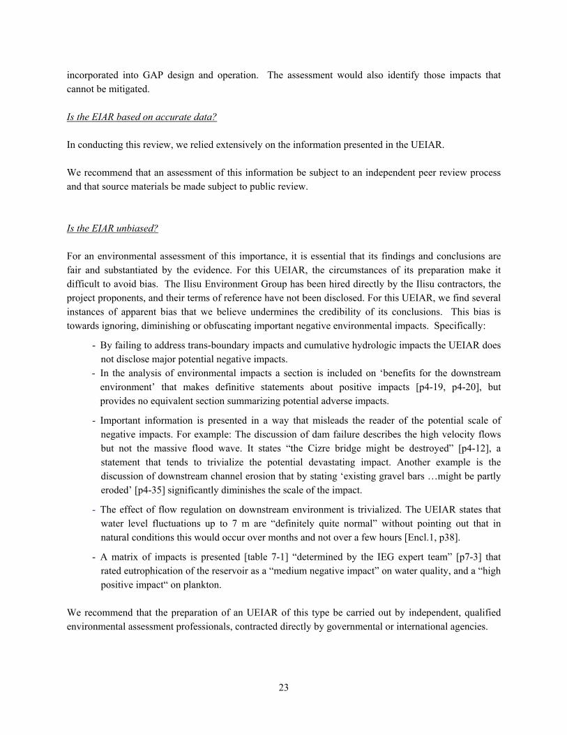
incorporated into GAP design and operation. The assessment would also identify those impacts that cannot be mitigated. Is the EIAR based on accurate data? In conducting this review, we relied extensively on the information presented in the UEIAR. We recommend that an assessment of this information be subject to an independent peer review process and that source materials be made subject to public review. Is the EIAR unbiased? For an environmental assessment of this importance, it is essential that its findings and conclusions are fair and substantiated by the evidence. For this UEIAR, the circumstances of its preparation make it difficult to avoid bias. The Ilisu Environment Group has been hired directly by the Ilisu contractors, the project proponents, and their terms of reference have not been disclosed. For this UEIAR, we find several instances of apparent bias that we believe undermines the credibility of its conclusions. This bias is towards ignoring, diminishing or obfuscating important negative environmental impacts. Specifically:
- By failing to address trans-boundary impacts and cumulative hydrologic impacts the UEIAR does not disclose major potential negative impacts.
- In the analysis of environmental impacts a section is included on ‘benefits for the downstream environment’ that makes definitive statements about positive impacts [p4-19, p4-20], but provides no equivalent section summarizing potential adverse impacts.
- Important information is presented in a way that misleads the reader of the potential scale of negative impacts. For example: The discussion of dam failure describes the high velocity flows but not the massive flood wave. It states “the Cizre bridge might be destroyed” [p4-12], a statement that tends to trivialize the potential devastating impact. Another example is the discussion of downstream channel erosion that by stating ‘existing gravel bars …might be partly eroded’ [p4-35] significantly diminishes the scale of the impact.
- The effect of flow regulation on downstream environment is trivialized. The UEIAR states that water level fluctuations up to 7 m are “definitely quite normal” without pointing out that in natural conditions this would occur over months and not over a few hours [Encl.1, p38].
- A matrix of impacts is presented [table 7-1] “determined by the IEG expert team” [p7-3] that rated eutrophication of the reservoir as a “medium negative impact” on water quality, and a “high positive impact“ on plankton.
We recommend that the preparation of an UEIAR of this type be carried out by independent, qualified environmental assessment professionals, contracted directly by governmental or international agencies.

24
Was the appropriate scientific analysis used in analyzing impacts? In our review we have identified a number of important impacts that could be better determined if contemporary analytic methods were used. It is not clear why, for a project of this magnitude, the best scientific knowledge is not being utilized. Specifically:
- Reservoir limnological models to predict circulation and water quality
- Water quality models to predict deterioration of downstream river flow
- Dynamic river flow models to predict stage fluctuations of peaking releases downstream
- River sediment transport models to predict expected channel aggradation upstream and erosion downstream of the dam
- Estimation of reservoir sedimentation requires more sophisticated sediment yield, as well as reservoir sedimentation modeling.
- Simulation of reservoir inflows needs to appropriately incorporate long term persistence of droughts in order to accurately represent hydrologic conditions at the dam site. Because of this inherent problem (Salas et al) the original feasibility study (1980) rejected the use of stochastic model of this type, stating “use of the synthetic record will therefore result in overestimation of the firm energy output [p 35].
Does the EIAR follow contemporary environmental assessment methodology? The UEIAR acknowledges that full compliance with World Bank, OECD or contemporary Turkish government regulations that were enacted after the project was designed cannot be ensured [p1-18]. The project description is not clear. Although the project is defined as a pure energy project, it is clearly designed to operate with Cizre Dam downstream. The UEIAR assumes implementation of water quality control measures and other mitigation measures that are not part of the project. It is noticeable that the discussion on the cumulative impacts not being addressed (Sect 1.1. of the 2001 EIAR) was deleted. Our review concludes that the UEIAR does not adequately identify all environmental impacts as required by contemporary environmental assessment guidelines because:
Water use and quality. The UEIAR does not quantify or provide a hydrologic analysis of the impacts on flows across the border downstream, when it is clear that the project will likely create over-demand. The UEIAR does not quantify or present reservoir water quality simulations to determine how severe water quality and public health impacts will be for the population around

25
the reservoir or downstream, when it is clear that the reservoir will likely contaminate water supplies.
Natural hazards. The UEIAR does not identify the area of influence at risk from dam failure and is dangerously misleading when it implies that large floods will be reduced downstream.
Ecology. The UEIAR does not quantify upstream and downstream river channel changes that have significant impacts on ecosystems. It does not address greenhouse gas emissions. A watershed management plan is discussed but not developed. No mechanism for implementing the plan is identified. Cumulative impacts are not evaluated.

26
REFERENCES
Aksoy, S., Ariturk, A., Armstrong, M.Y.K., Chang, K.P., Dortbudak, Z., Gottlieb, M., Ozcel, M.A., Richards, F.F., and K. Western. 1995. The GAP Project in southeastern Turkey: the potential for emergence of diseases. Emerging Infectious Diseases 1(2): 62-62. Al-Ansari, N.A. 1997. The influence of the Mosul Dam on the bed sediments and morphology of the River Tigris. Pp. 291-300 in D.E. Walling and J-L. Probst (eds.): Human Impact on Erosion and Sedimentation. IAHS Publication No.245. 311 pp. Al-Taiee, T.M. 1990. The influence of a dam on the downstream degradation of a river bed: case study of the Tigris River. Pp. 153-160 in R.O. Sinniger and M. Monbaron (eds.): Hydrology in Mountainous Regions II, Artificial Reservoirs Water and Slopes. IAHS Publication No.194. 446 pp. Bilen, O. 1997. Turkey and Water Issues in the Middle East. Southeastern Anatolia Project (GAP) Regional Development Administration, Ankara. 223 pp. Environmental Resources Management (ERM). 1999. Ilisu EIA Review EOS Transactions of the American Geophysical Union. 2001. Mesopotamian Fertile Crescent nearly gone, new study indicates. vol. 82 (24). Gogus, M. and G. Yener. 1997. Estimation of Sediment Yield Rates for Reservoirs in Turkey. Commission Internationale des Grand Barrages, 19ème Congrès des Grands Barrages, Florence 1997. Ilisu Engineers Group (IEG). 2001. Ilisu Dam and HEPP Environmental Impact Assessment Report (EIAR). International Commission on Large Dams (ICOLD). 1987. Dam Safety- Guidelines. Bulletin 59. 185 pp. International Waters of the Middle East; From Euphrates-Tigris to Nile. 1994. Ed. by A.K.Biswas. Water Resources Management Series:2. Oxford University Press. 221 pp. Kliot, N. 1994. Water Resources and Conflict in the Middle East. Routledge Press. 309 pp. Kolars, J.F. and W.A.Mitchell.1991. The Euphrates River and the Southeast Anatolia Development Project. Southern Illinois University Press. 324 pp. Mahmood, K. 1987. Reservoir Sedimentation Impact, Extent, and Mitigation. World Bank Technical Paper No. 71. 118 pp.

27
McCully, P. 1996. Silenced Rivers; The Ecology and Politics of Large Dams. Zed Books, London. 350 pp. Morris, G.L. and J. Fan. 1998. Reservoir Sedimentation Handbook. Design and Management of Dams, Reservoirs, and watersheds for Sustainable Use. Mc-Graw Hill Newson, M. 1997. Land, Water and Development, Sustainable Management of River Systems. Second Edition. Routledge, New York. 423 pp. PWA. 2001. A review of the Hydrologic and Geomorphic Impacts of the Proposed Ilisu Dam. PWA Ref. # 1527 Salas, J.D., J.W. Delleur, V. Yevjevich, and W.L. Lane. 1980. Applied Modeling of Hydrologic Time Series. Water Resources Publication, Colorado, U.S.A. United Nations Environmental Program (UNEP) International Environmental Technology Center. 1999. Planning and Management of Lakes and Reservoirs; An Integrated Approach to Eutrophication. Technical Publication Series 11. Osaka, Shiga. 375 pp. World Commission On Dams (WCD). 2000. Dams and Development; A New Framework for Decision-Making. Earthscan Publications LTD, London and Sterling, VA. 404 pp.
http://www.gap.gov.tr

APPENDIX A
Estimates of Flow Changes

(Assuming Ilisu/Cizre flow ratio of 0.93 and and using synthetic flows at Ilisu for average conditions. UEIAR, Encl.1, p.12 and 26)
billion m3 m3/sOct 0.39 148.9Nov 0.64 246.5Dec 1.01 390.2Jan 0.97 372.8Feb 1.48 569.3Mar 2.52 971.0Apr 3.73 1437.8May 2.96 1143.6Jun 1.27 490.2Jul 0.53 203.5Aug 0.32 122.3Sep 0.28 108.8
16.08
VERIFICATION FROM KLIOT (1994):Flows at Mosul is 1.1 times the flows at Cizre (16.6 vs 18.4)
Flows at Mosul Flows at Cizre billion m3 m3/s billion m3 m3/s
Oct 0.45 173.61 0.41 157.83Nov 0.66 254.63 0.60 231.48Dec 0.9 347.22 0.82 315.66Jan 1.26 486.11 1.15 441.92Feb 1.98 763.89 1.80 694.44Mar 2.5 964.51 2.27 876.82Apr 3.96 1527.78 3.60 1388.89May 3.42 1319.44 3.11 1199.49Jun 1.68 648.15 1.53 589.23Jul 0.82 316.36 0.75 287.60Aug 0.45 173.61 0.41 157.83Sep 0.32 123.46 0.29 112.23
18.4 16.73
Mean monthly flow of the Tigris at Cizre

"Irrigation Water Needs" in the Euphrates Basin from GAP 1980
m3/ha/mo m/moApril 405.34 0.041May 832.87 0.083June 2090.56 0.209July 2890.21 0.289August 2438.08 0.244September 1169.28 0.117October 172.37 0.017
9998.71 1.000
Kolars and Mitchell states that after taking into acount potential evapotranspiration with losses that is amount withdrawn (2.5 times PE) and the return flow (35% of the amount withdrawn)the irrigation requirement becomes approximately 1.6 m (1*2.5 -(2.5*0.35)=1.6)Asuming the same distribution for the Tigris Basin with corrected consumptive use:
m/mo m3/mo m3/s m3/mo m3/s m3/mo m3/sApril 0.066 79,376,000 30.62 90,724,800 35.00 336,528,000 129.83May 0.133 160,688,000 61.99 183,662,400 70.86 681,264,000 262.83June 0.334 404,624,000 156.10 462,475,200 178.42 1,715,472,000 661.83July 0.462 559,504,000 215.86 639,499,200 246.72 2,372,112,000 915.17August 0.390 472,384,000 182.25 539,923,200 208.30 2,002,752,000 772.67September 0.187 226,512,000 87.39 258,897,600 99.88 960,336,000 370.50October 0.027 32,912,000 12.70 37,617,600 14.51 139,536,000 53.83
1.600
Downstream (planned) Upstream (in construction, in use) Upstram (total)121,000 ha 513,000 ha138,300 ha
Kolars and Mitchell (1991)

UPSTREAM of ILISUAverage monthly flows after consumptive use for irrigation of 138,287 ha (existing) and 513,000 ha (planned)
Flows from UEIAR
Irrigation Use InflowsInflows w/o
negative Irrigation Use InflowsInflows w/o
negativem3/s m3/s m3/s m3/s m3/s m3/s m3/s
Oct 138.49 14.51 123.98 123.98 53.83 84.66 84.66Nov 229.27 229.27 229.27 229.27 229.27Dec 362.87 362.87 362.87 362.87 362.87Jan 346.68 346.68 346.68 346.68 346.68Feb 529.48 529.48 529.48 529.48 529.48Mar 903.00 903.00 903.00 903.00 903.00Apr 1337.17 35.00 1302.17 1302.17 129.83 1207.34 1207.34May 1063.58 70.86 992.72 992.72 262.83 800.75 800.75Jun 455.91 178.42 277.49 277.49 661.83 -205.92 0.00Jul 189.26 246.72 -57.46 0.00 915.17 -725.91 0.00Aug 113.70 208.30 -94.60 0.00 772.67 -658.97 0.00Sep 101.17 99.88 1.29 0.00 370.50 -269.33 0.00
DOWNSTREAM of ILISUAverage flows from Ilisu (EIAR (2001), p4-42)
OutflowsIrrigation use for
121,000 haInflows w/o
negativem3/s m3/s m3/s
Oct 240 12.70 227.30Nov 520 520.00Dec 520 520.00Jan 530 530.00Feb 540 540.00Mar 680 680.00Apr 680 30.62 649.38May 680 61.99 618.01Jun 440 156.10 283.90Jul 240 215.86 24.14Aug 240 182.25 57.75Sep 240 87.39 152.61
138,300 ha 513,000 ha

APPENDIX B
The press release by VA Tech Hydro on November 26, 2005


APPENDIX C
Correspondences with the IEG

January 31, 2006 Mr. Alexander Schwab VA TECH HYDRO GmbH & Co Penzinger Strasse 76 P.O. Box 5 A-1141 Vienna RE: Ilisu Dam UEIAR References PWA Ref No: P06-006 Dear Mr. Schwab: We have been engaged to review the updated version of the Ilisu Dam and HEPP Environmental Impact Assessment Report (2005) with respect to hydrologic and geomorphic impacts (downloaded from http://www.ilisu-wasserkraftwerk.com/page.php?modul=HTMLPages&pid=46). In reviewing the UEIAR, we have noted the following references that would support our review: 1. Dolsar Engineering Ltd. 1997. Ilisu Dam and Hydroelectric Power Plant Project, Summary Report, Ankara, pp 17+11 figures (# 30 in the References Section) 2. Dolsar Muhendislik Limited Sirketi. 1997. Dicle-Ilisu Operation Study (# 31) 3. Ilisu Dam and Hydroelectric Power Plant Project Interim Report, September 1997 (# 83) 4. Ilisu Hydropower Consultants: Ilisu Dam and HEPP and Cizre Dam and Hydroelectric Plant Project, Loan Application Report, 1983 (# 84) 5. Ilisu Hydropower Consultants: Design Reports, Volume 1. Technical and Economical Feasibility Report, December 1977 (# 86) 6. Ilisu Hydropower Consultants. Ilisu Dam and HEPP Project Design Reports Volume 12, Reservoir Operation, July 1982 (# 99) 7. Temel Consulting Eng. Inc. Dicle-Ilisu Project, Dicle Project Feasibility Report, Vol I, 1977 (# 163) 8. Temel Consulting Eng. Inc. Dicle-Ilisu Project Feasibility Report, Hydrology, Vol II, 1977 (# 164 and #354) 9. Dicle University. GAP Region Environment Study Dicle Basin (Environmental Study for Diyarbakir and Surroundings). Executive Summary. Mart 1993 (# 24) 10. Answers and Comments to Questions Raised by ERM for the Ilisu EIAR: Water Quality & Associated Environmental Impacts (#305)

Mr. Alexander Schwab January 31, 2006 Page 2
P:\Proposals\2006\06-006_IlisuDam\Ilisu-Document_Request_Letter.doc
11. DSI. Topographic Maps, covering the total Ilisu River Basin (#328) 12. Sen, Z. Ilisu Environmental Impact Assessment Report Hydrological Study with Simple Management. Hydrosen Research Center (#353) 13. DSI. A Leaflet Showing the Names, Numbers, Longitude, Latitude, and Altitude of Stations (#369) 14. GAP. Republic of Turkey, Prime Ministry, Southeastern Anatolia Project, Regional Development Administration; Status Report, June 2000 (#264) 15. DSI & Encon. Mart 2005. Ilisu Baraji ve Hidroelektrik Santrali Projesi – Bilgilendirme Kitapcigi- Diyarbakir, Batman, Siirt, Sirnak, Mardin 16. EIE. Dicle Ilisu Baraj Rezervuari Kamulastirma Raporu (Revize 1979) (Dicle-Ilisu Dam Reservoir Expropriation Report) (Revised in 1979). Prepared by the Directorate of Sediment Survey Technical Commission. Pp 36. 1979 (# 45) In order to complete our review, we need to obtain the above referenced documents. Due to time constraints we need access to these documents as expeditiously as possible. We would very much appreciate it if you would immediately forward those referenced documents that you have in your possessions. If there are some documents that you do not have, please let us know where and how we can get them. Thank you for your cooperation in this matter. We look forward to hearing from you shortly. Sincerely,
Setenay B Frucht Geomorphologist, Associate

APPENDIX D
List of Source Documents Provided by the Ilisu Consortium

1. Dolsar Engineering Ltd. 1997. Ilisu Dam and Hydroelectric Power Plant Project, Summary Report, Ankara, pp 17+11 figures (# 30) 2. Ilisu Hydropower Consultants. Ilisu Dam and Hydroelectric Power Plant Project Interim Report, September 1997 (# 83) 3. Ilisu Hydropower Consultants: Ilisu Dam and HEPP and Cizre Dam and Hydroelectric Plant Project, Loan Application Report, 1983 (# 84) 4. Ilisu Hydropower Consultants. Ilisu Dam and HEPP Project Design Reports Volume 12, Reservoir Operation, July 1982 (# 99) 5. Temel Consulting Eng. Inc. Dicle-Ilisu Project, Dicle Project Feasibility Report, Technical and Economical Feasibility Report, Vol 1, 1977 (# 163) 6. Temel Consulting Eng. Inc. Dicle-Ilisu Project Feasibility Report, Hydrology, Vol II, 1977 (# 164) 7. Answers and Comments to Questions Raised by ERM for the Ilisu EIAR: Water Quality& Associated Environmental Impacts 8. DSI & Encon. Mart 2005. Ilisu Baraji ve Hidroelektrik Santrali Projesi – Bilgilendirme Kitapcigi (Information Brochure- March 2005)- Diyarbakir, Batman, Siirt, Simak, Mardin

APPENDIX E
Emerging Infectious Diseases in the GAP Region