Embed Size (px)
Citation preview

A Review of Information on Fish Stocks And Harvests in the South Slave Area, Northwest Territories
D.B. Stewart
Central and Arctic RegionDepartment of Fisheries and OceansWinnipeg, Manitoba R3T 2N6
1 Arctic Biological ConsultantsBox 68, St. Norbert Postal Station95 Turnbull Drive, Winnipeg, MB, R3V 1L5.
1999
Canadian Manuscript Report of Fisheries and Aquatic Sciences 2493
Fisheries Pêches and Oceans et Océans

Canadian Manuscript Report of
Fisheries and Aquatic Sciences 2493
1999
A REVIEW OF INFORMATION ON FISH STOCKS AND HARVESTS
IN THE SOUTH SLAVE AREA, NORTHWEST TERRITORIES
by
D.B. Stewart1
Central and Arctic Region
Department of Fisheries and Oceans
Winnipeg, Manitoba R3T 2N6
1 Arctic Biological Consultants, Box 68, St. Norbert Postal Station, 95 Turnbull Drive,
Winnipeg, MB, R3V 1L5.

ii
PREFACE
This report was prepared under contract for the Department of Fisheries and Oceans, Central and ArcticRegion, 501 University Crescent, Winnipeg, Manitoba, R3T 2N6. The Scientific Authority for this contract was Larryde March of the Resource Management Division.
© Minister of Supply and Services Canada 1999
Cat. no. Fs 97-4/2493E ISSN 0706-6473
Correct citation for this report is:
Stewart, D.B. 1999. A review of information on fish stocks and harvests in the South Slave area, NorthwestTerritories. Can. Manuscr. Rep. Fish. Aquat. Sci. 2493: iv + 65 p.
iii
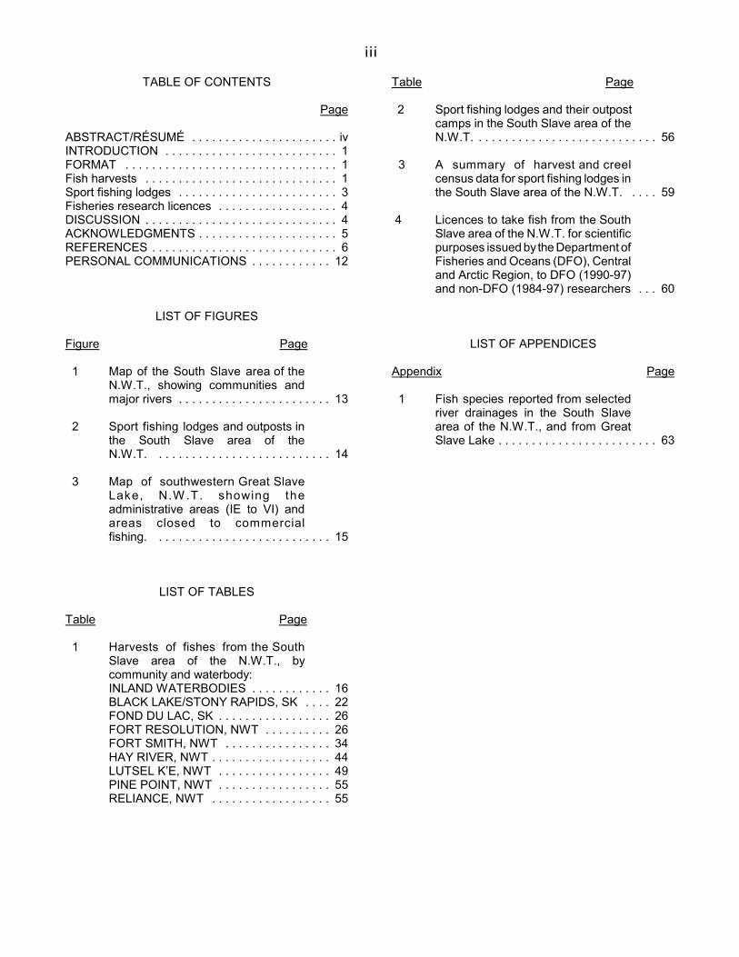
TABLE OF CONTENTS
Page
ABSTRACT/RÉSUMÉ . . . . . . . . . . . . . . . . . . . . . . ivINTRODUCTION . . . . . . . . . . . . . . . . . . . . . . . . . . 1FORMAT . . . . . . . . . . . . . . . . . . . . . . . . . . . . . . . . 1Fish harvests . . . . . . . . . . . . . . . . . . . . . . . . . . . . . 1Sport fishing lodges . . . . . . . . . . . . . . . . . . . . . . . . 3Fisheries research licences . . . . . . . . . . . . . . . . . . 4DISCUSSION . . . . . . . . . . . . . . . . . . . . . . . . . . . . . 4ACKNOWLEDGMENTS . . . . . . . . . . . . . . . . . . . . . 5REFERENCES . . . . . . . . . . . . . . . . . . . . . . . . . . . . 6PERSONAL COMMUNICATIONS . . . . . . . . . . . . 12
LIST OF FIGURES
Figure Page
1 Map of the South Slave area of theN.W.T., showing communities andmajor rivers . . . . . . . . . . . . . . . . . . . . . . . 13
2 Sport fishing lodges and outposts inthe South Slave area of theN.W.T. . . . . . . . . . . . . . . . . . . . . . . . . . . 14
3 Map of southwestern Great SlaveLake, N.W .T. showing theadministrative areas (IE to VI) andareas closed to commercialfishing. . . . . . . . . . . . . . . . . . . . . . . . . . . 15
LIST OF TABLES
Table Page
1 Harvests of fishes from the SouthSlave area of the N.W.T., bycommunity and waterbody:INLAND WATERBODIES . . . . . . . . . . . . 16BLACK LAKE/STONY RAPIDS, SK . . . . 22FOND DU LAC, SK . . . . . . . . . . . . . . . . . 26FORT RESOLUTION, NWT . . . . . . . . . . 26FORT SMITH, NWT . . . . . . . . . . . . . . . . 34HAY RIVER, NWT . . . . . . . . . . . . . . . . . . 44LUTSEL K’E, NWT . . . . . . . . . . . . . . . . . 49PINE POINT, NWT . . . . . . . . . . . . . . . . . 55RELIANCE, NWT . . . . . . . . . . . . . . . . . . 55
Table Page
2 Sport fishing lodges and their outpostcamps in the South Slave area of theN.W.T. . . . . . . . . . . . . . . . . . . . . . . . . . . . 56
3 A summary of harvest and creelcensus data for sport fishing lodges inthe South Slave area of the N.W.T. . . . . 59
4 Licences to take fish from the SouthSlave area of the N.W.T. for scientificpurposes issued by the Department ofFisheries and Oceans (DFO), Centraland Arctic Region, to DFO (1990-97)and non-DFO (1984-97) researchers . . . 60
LIST OF APPENDICES
Appendix Page
1 Fish species reported from selectedriver drainages in the South Slavearea of the N.W.T., and from GreatSlave Lake . . . . . . . . . . . . . . . . . . . . . . . . 63
;
iv
ABSTRACT
Stewart, D.B. 1999. A review of information on fishstocks and harvests in the South Slave area,Northwest Territories. Can. Manuscr. Rep.Fish. Aquat. Sci. 2493: iv + 65 p.
This document was prepared to assist theDepartment of Fisheries and Oceans (DFO) and theRenewable Resources Board(s), which may beappointed in the future, to co-manage fisheries in theSouth Slave area. It reviews information on stocks offishes that are harvested for subsistence, commerceand sport in the area south and east of Great SlaveLake. The information is current to February 1998. Itis summarized in tables that are organizedhierarchically by community, waterbody, and thenspecies. Recent recommendations by DFOconcerning management of the fisheries or stocks aresummarized, with a list of pertinent references.Information is also provided on sport fishing lodgesoperating in the area, and on Scientific Licencesissued by DFO since 1984 for research in the area.
Key words: Subarctic zone; fishery management;subsistence fishing; commercial fishing; sportfishing; catch statistics; stocking.
RÉSUMÉ
Stewart, D.B. 1999. A review of information on fishstocks and harvests in the South Slave area,Northwest Territories. Can. Manuscr. Rep.Fish. Aquat. Sci. 2493: iv + 65 p.
Ce document a pour objet d'aider le ministèredes Pêches et des Océans (MPO) et les Conseil desressources renouvelables, qu’il soit constitué dansl’avenir, à gérer conjointement la pêche dans la régiondu sud et de l’est du Grand lac des Esclaves (regionSouth Slave). Il contient des renseignements sur l'étatdes stocks de poissons capturés à des fins sportives,commerciales et de subsistance dans cette region.Ces donées sont valides jusqu'en février 1998. Aumoyen de tableaux, on en fait la synthèse de manièrehiérarchique, selon la localité, le cours d'eau ou le lac,puis l'espèce visée. De plus, on présente un résumédes dernières recommandations du MPO concernantla gestion de la pêche et des stocks, accompagnéd'une liste de références. Enfin, on donne desrenseignements sur les pourvoiries de pêche sportiveet sur les permis delivrés depuis 1984 par le MPO àdes fins de recherche scientifiques dans la région.
Mots clés: Subarctique; gestion de la pêche; pêche desubsistance; pêche commerciale; pêchesportive; statistiques sur les priseensemencement.
1
INTRODUCTION
Land claims negotiations are ongoingbetween the Aboriginal peoples who havetraditionally lived in the South Slave area, which liessouth and east of Great Slave Lake, and theGovernment of Canada. One of the provisions ofeach recent Land Claim Agreement in the NorthwestTerritories has been the establishment of aRenewable Resources Board. A similar body islikely to be established upon settlement of the SouthSlave negotiations.
These Renewable Resource Boards typicallyhave equal representation of the Aboriginal peoplesof the Settlement Area and Government, plus achairperson. They are charged with making alldecisions about wildlife management in theSettlement Area, including those on many mattersnow controlled by the federal Department ofFisheries and Oceans (DFO), the Canadian WildlifeService, and the territorial Department of Resources,Wildlife and Economic Development. Theirdecisions remain subject to review by theappropriate Minister of the Government of Canadaor Minister of the Government of the NorthwestTerritories. The purpose of this report is to provide DFOand any future Renewable Resources Board(s) andAboriginal First Nations government(s) with asummary of information on fish stocks and harvestsin the South Slave area (Fig. 1). These stocks areharvested for subsistence, commerce and sport,mostly by Aboriginal residents of the NorthwestTerritories and Saskatchewan, and by visiting sportfishermen. Aboriginal residents of northern Albertahave good fish resources nearby and seldom fish inthe Northwest Territories (B. Bergmann, G. Low, andD. Moshenko, pers. comm.). As the bounds of thesettlement area have yet to be established, thisstudy may include some waterbodies that areoutside the eventual land settlement or that straddlesettlement boundaries. The study area does notinclude Great Slave Lake. Similar studies havebeen prepared for the Nunavut, Sahtu and Gwich'insettlement areas and for the North Slave area(Stewart 1994, 1996a+b, 1997).
The published and unpublished sources ofinformation in this summary were identified bysearches of bibliographic databases and publishedbibliographies (e.g. Nicholson and Moore 1982a-c),and by discussions with fishery managers andscientists knowledgeable of fisheries resources inthe region. The bibliographic databases searched
were those of B.W. Fallis (DFO, Winnipeg) and theauthor. DFO files were also searched forunpublished information.
FORMAT
The summary is presented in tabular form,with the fishery data organized hierarchically first bycommunity and then by waterbody and taxa. Theobjective of this is to enable fishery managers toquickly review the data on a community or speciesbasis.
FISH HARVESTS (TABLE 1)
Information on the harvests of freshwaterfishes from waterbodies in the South Slave area issummarized in Table 1. Waterbodies that could notbe assigned to a particular community are discussedfirst, under the heading "Inland waterbodies". Thecommunities are then discussed in alphabeticalorder, as follows: Black Lake/Stony Rapids, Fonddu Lac, Fort Resolution, Fort Smith, Hay River,Lutsel K’e, Pine Point, and Reliance. Waterbodiesfished by their residents, or in the vicinity, are listedalphabetically for each community. Where severalspecies are harvested at a waterbody, they are listedalphabetically by common name. The Latinscientific name for each species is given in Appendix1.
Where a waterbody is fished by more thanone community, cross references have beenincluded to avoid repetition. Cross references towaterbodies within the same community section areindicated by "see above" or "see below"; those towaterbodies within another community section areindicated by the community name and waterbody(e.g. see BLACK LAKE--Damant Lake).
Included in Table 1 are those waterbodiesthat have a record of commercial, subsistence orsport harvest, or are listed in Schedule V of theNorthwest Territories Fishery Regulations. Anumber of waterbodies for which no harvest datawere found have also been included. They providecritical spawning and nursery habitats for fishes, andsupport important subsistence and sport harvests.Studies to predict the potential impacts ofhydroelectric or mining developments or ofharvesting have documented the biota of a numberof these waterbodies. Where such informationexists, the waterbody has been included together

2
with a brief summary of the study results.
Each fishing location is identified by itsproper geographical name and a latitude andlongitude taken from the Canada Gazetteer. Insome cases, a local name or geographical feature isalso included in brackets. Map coordinates forwaterbodies not listed in the Canada Gazetteer weretaken from Schedule V of the Northwest TerritoriesFishery Regulations, from the source of the data, ordetermined from 1:250,000 scale topographicalmaps. An alphanumeric code that identifies the mapon which the waterbody coordinates are located isprovided in brackets (e.g. “(75C)”) at the end of thesection on each waterbody.
For each waterbody with harvest data, thetable identifies the species harvested and providesthe harvest quota(s), the most recent harvest data,a summary of stock status if available, and a list ofpertinent references. Species are treated separatelyif they have separate quotas. For each waterbodywithout harvest data, the table summarizes andreferences the results of pertinent fisheries research.The number of species reported by these studiesprecludes listing them individually for eachwaterbody. Species reported by the studiesexamined are listed in Appendix 1 for selectedwaterbodies. This listing is intended to support thecomments in Tables 1. It is not the result of anexhaustive review of the literature on species'occurrences.
All site specific harvest data located duringthis work for the South Slave area are summarizedin Table 1. Non-site specific community harvestdata have also been included, where available, forcomparison.
The harvest quotas are from varioussources, and some more closely reflect the stockstatus than others. The quotas of active commercialand sport fisheries are reviewed annually by DFO.If information from the harvesters or from samplingsuggests that the fishery is not sustainable then thequota is adjusted downward. If that informationsuggests under-utilization then it may be adjustedupward, in the case of a commercial fishery, or bekept as is to improve the quality of the fishery, in thecase of a trophy sport fishery. The experimentalquotas, in square brackets, are interim quotasassigned for the purpose of obtaining samples froma fishery. In the past, experimental fisheries wereknown as exploratory or test fisheries. Abbreviationsare used to indicate years when a harvest may havetaken place but that no data are available "(NA)",
and when a waterbody was opened for fishing byVariation Order but not fished "(NF)". "No quota", ora blank quota cell in the table, indicates that DFOhas not assigned a commercial quota to thewaterbody, either as a whole or for a particularspecies. This does not necessarily mean that thereare no commercial fishing opportunities in thewaterbody or for the species.
The quota and harvest years are the sameas the federal government fiscal year (e.g. the 1998quota extends from 1 April 1998 to 31 March 1999).They are not the normal calendar years.
Unless otherwise indicated, the harveststatistics are for commercial fisheries and inkilograms round weight. A "round" weight is that ofa whole fish, while a "dressed" weight is that of a fishwith the viscera and gills removed. It was not alwayspossible to separate the harvests by species formixed species fisheries, or to determine how thedata were collected. The commercial harvest dataare from export or local sales records, and tend tobe conservative as they do not estimate culls andpersonal use. Care, then, must be taken wheninterpreting these data.
The general comments column of the tablesprovides a brief summary of the informationavailable for each waterbody. It tells whether thereis an established or experimental fishery, active orinactive or in conflict with other fisheries; when it waslast sampled for, or by, DFO; what is known of thestock status; whether spawning or nursery habitatshave been identified in the system; whether thewaterbody has been stocked with fish; and recentrecommendations by DFO concerning managementof the fishery. Comments on habitat use andsubsistence harvests are summaries of site-specificaquatic resource assessment research. Referencematerial pertinent to each fishery is listed in bracketsand cited in full in the bibliography.
General information for communities isdiscussed beside the community headings (e.g.FORT SMITH), whereas site-specific harvest dataare discussed under the appropriate waterbody.
There are few data available on subsistenceharvests in the South Slave area. Indeed, most ofthose described here were documented prior to1985, and their present status and extent have notbeen documented. Descriptions of the subsistencefisheries can be found in Keleher and Haight 1965;Sinclair et al. 1967, Radojicic 1968, Bone et al.1973, Bodden 1980, RL&L/EMA Slave River Joint

3
Venture 1985, and Roberge et al. 1985.
Sport fishing limits are listed in the annualSport Fishing Guide for the Northwest Territories.Special limitations on sport fishing are in force forlake trout in Stark Lake and tributary streams ofGreat Slave Lake. These waters have a daily catchand possession limits of 2 and 3 lake trout,respectively, and only one trout can be over 70 cmin fork length.
Guest-bed capacities, which relate theestimated total sustainable yield of fish from a laketo the estimated harvest per sport angler (Roberge1982), are included in Table 1. Only DFO's mostrecent guest-bed capacity estimate is included foreach lake. This estimate may not correspond to thelicensed guest-bed capacity of a lodge, since theGovernment of the Northwest Territories ultimatelyassigns the guest-bed capacity and licences theoperation. Outfitters are now being assigned "guest-beds" for the lakes they frequent (A.C. Day, pers.comm.).
DFO guest-bed estimates are based on therate of angler exploitation (kg Cha-1Cy-1) and otherfactors such as the presence of competing fisheries(Roberge 1982; A.C. Day, pers. comm.). A "highquality" or "trophy" lake trout fishery, for example,has an exploitation rate of 0.05 to 0.10 kg of laketrout per hectare of lake surface area per year. Atthis low rate of harvest the lake should sustain afishery for large lake trout. At a moderate rate ofexploitation, 0.11 to 0.15 kg Cha-1Cy-1, the lake shouldsustain a "medium quality" fishery for moderate-sized lake trout; at a high rate of exploitation, 0.16 to0.25 kg Cha-1Cy-1, it should sustain a "low quality"fishery for small lake trout. Prior to 1982, a fisherynow described as a "medium quality" was describedas a "high quality", and "low" as "medium". Theseearlier designations have been standardized toreflect the new, more conservative recommendedexploitation rates.
At the request of some lodges and outfittersin the Northwest Territories, fishery managers arenow recommending harvest quotas in terms of thenumber of fish that can be harvested annually by alodge from a particular lake (A.C. Day, pers. comm.).This method of regulating the fishery has theadvantage of not limiting the guest capacity of thelodge, which may offer other activities to its guests,while still limiting the harvest of fish by lodge gueststo a sustainable level.
Table 1 summarizes information from
studies directed towards the assessment andmanagement of commercial, subsistence, and sportfisheries. It does not summarize other scientificresearch directed towards a more generalunderstanding of the aquatic environment. Useful inthis regard are the:
reviews of the Mackenzie River system by:Mackenzie River Basin Committee 1981a; Brunskill1986; McCart 1986; Bodaly et al. 1989;
aquatic resource surveys of: Nelson and Paetz1972; Falk 1979; MacDonald and Fudge 1979;MacDonald and Stewart 1980;
studies of fish ecology in the Slave River by:Mackenzie River Basin Committee 1981b; Tripp etal. 1981; RL&L/EMA Slave River Joint Ventures1985; Tallman 1996; Tallman et al. 1996 a-c;Howland 1997; Little 1997;
studies of fish ecology in the Taltson River by:Envirocon Limited et al. 1975; Envirocon Pacific Ltd.1986; and,
species accounts of: Fuller 1955; Harris 1962;Buchwald 1968; McPhail and Lindsey 1970; andJohnson 1976.
Resource maps in the Northern Land UseInformation Series (NLUIS), which were producedbetween 1972 and 1979 by the Lands Directorate ofthe Department of Fisheries and Environment, arealso useful general references. They are referred toin text by number (e.g. NLUIS 75F) and have beenavailable from the Surveys and Mapping Branch ofthe Department of Energy, Mines, and Resources inOttawa.
SPORT FISHING LODGES (TABLES 2 and 3)
Table 2 summarizes information on the sportfishing lodges of the South Slave area (Fig. 2). Thelodges are listed alphabetically. The latitude andlongitude, operating season, guest-bed capacity,and species sought are listed for each lodge.Outpost camp locations, recent operating history,and the most recent DFO creel censuses are listedin the comments section, as are any pertinentreferences. The main sources of information for thistable were the GNWT Economic Development andTourism (S. Ransom, pers. comm.; D. Gray, pers.comm.), the GNWT Explorers Guides 1988-98, andDFO (C. Craig, pers. comm.). Lodges located incommunities or on the shores of Great Slave Lake,

4
and outfitters operating from communities or withmoveable camps, are not included in this summary.The outfitting operations are discussed in Table 1,with the other information on the lakes that theyfrequent.
Harvest and creel census data from sportfishing lodges in the South Slave area aresummarized in Table 3. In a general comment foreach lodge are listed its latitude and longitude,operating season, guest-bed capacity, targeted fishspecies, outpost camp locations, recent operatinghistory, participation in fishery management studies,and pertinent references. Beneath this comment thefish species harvested are listed alphabetically.Harvest data for each species are listed by year.They include an estimate of the number of fish killedby the sport fishery, the average number of fishcaught per angler hour, and an estimate of the totalnumber of angler days. The sources of these dataare described and referenced in a commentssection.
FISHERIES RESEARCH LICENCES (TABLE 4)
Table 4 summarizes information on theScientific Licences that DFO has issued to itspersonnel or to non-DFO personnel since 1984, forwork in the South Slave area (J.T. Strong andD.Wright, pers. comm.). These licences permitthem to take fish for scientific purposes. Thisinformation is organized alphabetically by licenceholder. The area where the research was to takeplace, its purpose, and the year for which the licencewas issued are shown for each licence holder. Theyears refer to the federal government fiscal year(see above). The outcome of the research is notdiscussed, but documents located are referenced.
In 1994, DFO began to distinguish betweenstudies that take fish for scientific, educational, andpublic display purposes (J.T. Strong, pers. comm.)Since then, separate licences have been issued foreach type of study, and studies that do not take fish(e.g. behavioural observations) no longer require aScientific Licence. These licences are now issuedunder Section 52 of the Fishery (General)Regulations.
DISCUSSION
Four main fishery management issues standout in the South Slave area: 1) the potential foroverharvesting by subsistence and sport fisheries, 2)potential for overharvesting of migratory stocks bythe Great Slave Lake commercial fishery, 3) thepotential for adverse impacts from hydroelectric andindustrial developments in the region and upstream,and 4) the quality of fishery information on which tobase resource management decisions.
Major commercial export fisheries have notdeveloped in the South Slave area due to the pooreconomics of remote fisheries for whitefish and laketrout, and to the better economics of tourist sportfisheries. In many of the larger lakes, the whitefishalso have high parasite cyst counts (Triaenophoruscrassus) in their flesh (G. Low and D. Moshenko,pers. comm.). These cysts reduce the market valueof the whitefish and can make them unacceptablefor commercial export (if >40 cysts/45 kg rd wt) orcontinental markets (if > 80 cysts/45 kg rd wt). Inconsequence, only a few of the many large inlandlakes (e.g. Kasba, Snowbird, Mosquito) have beenstudied in detail for the purpose of sport fisherymanagement. Indeed, the aquatic resources of suchlarge lakes as Firedrake, Whitefish, and Wholdaiaremain virtually unknown.
The issue of overharvesting by subsistenceand sport fishermen is particularly important forwalleye in the Hay River, lake whitefish in the LittleBuffalo River, and inconnu in the Buffalo River. Todate, the Hay River walleye and Little Buffalo Riverwhitefish do not appear to have been overharvested.Buffalo River inconnu have been overharvested, notby the subsistence or sport fisheries but by the GreatSlave Lake commercial fishery. This inconnu stockremains depleted. There is an important traditionalsubsistence fishery for inconnu in the Slave Rivernear Fort Smith. At present these fish are notheavily exploited for subsistence, but they are animportant harvest of the commercial fishery forinconnu in Great Slave Lake. Burbot, inconnu andlake whitefish are harvested in quantity forsubsistence from the lower Slave River and SlaveRiver Delta by Aboriginal residents of FortResolution. The present extent of this harvest isunknown.
The Hay River walleye population isharvested mainly for sport and, to a lesser extent forsubsistence. Because of the large sport fishery atHay River, the stock has been monitored by DFOsince 1972 (Gillman and Dahlke 1973; Falk and
5
Dahlke 1975; Bond et al. 1978; Moshenko and Low1980; Falk 1981; Clarke et al. 1989). Despite strongharvest pressure it seems to sustain itself, perhapsdue in part to the fact that in some years the river ishigh and murky throughout the fishing season socatches are poor and the stock gets a rest courtesyof Mother Nature (G. Low, pers. comm.). The stockdefinition is unknown, except that harvested fish arenot part of a spawning run as they are eitherimmature or unripe adults. A spawning run mayoccur in the river just after break-up but be misseddue to the severe runoff conditions (G. Low, pers.comm.). There is a large domestic fishing area offthe mouth of the Hay River that is closed tocommercial harvest (Fig. 3), so few Hay Riverwalleye are taken by the commercial fishery. TheAboriginal food fishery also takes few walleye asmost nets are set in Great Slave Lake, in deep areasof the river, or in the late fall when feeding walleyehave migrated out of the river and catch few walleye.
The Little Buffalo River lake whitefish areexploited mainly by the Aboriginal food fishery atFort Resolution. DFO has monitored this fisherysince 1975 (Roberge et al. 1985; A.C. Day and G.Low unpubl. data). The fish are harvested mainlyduring the post-spawning run in late September andOctober in the lower 2.5 km of the river. Thesubsistence harvest and rate of exploitation varywidely from year to year, but appear to besustainable at present.
Inconnu congregate at the mouth of theBuffalo River in the spring and in summer migrateupstream to Buffalo Lake, where they spawn in itstributary streams in the fall before returningdownstream (Day and Low 1993). The population isexploited by the Great Slave Lake commercialfishery and for subsistence. The stock definition isunknown. DFO considers inconnu stocks in theBuffalo River to have been severely overexploited,and has taken measures to reduce the impact of theGreat Slave Lake commercial fishery on the stock.Despite these measures, recovery of the BuffaloRiver stock is expected to be slow (Day and Low1993). The Slave River stock is being monitoredand protected by DFO to prevent a similaroccurrence there (G. Low, pers. comm.).
The harvests by tourist sport lodgeoperations are poorly known to DFO, as they haveonly been studied briefly in the late 1970's or early1980's. In the absence of data on both the exploitedstocks and harvests, fishery managers must rely onguest-bed capacities or harvest quotas to regulate
these fisheries. Studies are required to measure thetrend to catch and release fishing and its effects onharvests (G. Low, pers. comm.).
The effect of the Great Slave Lakecommercial fishery on the Aboriginal food fishery isof particular concern to area residents (Stewart et al.1999). In 1996, on the recommendation of the GreatSlave Lake Advisory Committee, the Fort Resolutiondomestic fishing boundary was moved westward toexpand the domestic fishing area and preventcommercial fishing near the mouth of the LittleBuffalo River (Fig. 3). This measure will remain ineffect until outstanding Dene and Metis land claimsin the South Slave area are settled, after which timeit may be reviewed by the Great Slave Lake AdvisoryCommittee. Inshore zones along the south shore ofGreat Slave Lake and near the Slave River Deltahave also been closed to commercial fishing in thespring to protect inconnu from the Slave River andfrom the threatened Buffalo River stock whichmigrate along the south shore and concentrate atthe river mouth in the spring.
Where detailed information does exist on aparticular waterbody, it has generally been gatheredto assess the impacts of resource development.These initiatives include studies of existing orproposed hydroelectric developments, on theTaltson and Slave rivers; studies of miningproperties such as the now abandoned ComincoPine Point Mine; and studies of organiccontaminants that may be carried down the SlaveRiver from industrial developments upstream.
The existing knowledge of fisheriesresources in the South Slave area is not sufficient toensure effective long term fishery management.Faced with increasing pressure from anglers anddevelopers, it will be important to improveknowledge of the area's aquatic resources,especially those of the most frequented inland lakes,and to further improve the documentation ofsubsistence fisheries and their harvests.
ACKNOWLEDGMENTS
George Low of DFO, Hay River; KenChang-Kue, Larry deMarch, Chris Day, DaveMoshenko and Ross Tallman of DFO, Winnipeg;and Cécile Stewart of Arctic Biological Consultantsgave freely of their time and expertise. Theyprovided much of the information in this report andundertook careful reviews of the manuscript at

6
various stages. Drew Bodally, Collette Craig, BruceFallis, Marilyn Hendzel, Dale McGowan, and DennisWright, of DFO, Winnipeg; Sam Ransom of GNWTRRWED Fort Smith; Dyan Gray of RRWED inRankin Inlet; Moira Gustafson of DFO Yellowknife;and many others also provided welcome informationand advice. Your participation has greatlystrengthened this project and I thank you.
REFERENCES
B.C. RESEARCH. 1977. Environmental survey andassessment, Pine Point, N.W.T. Preparedfor Cominco Ltd., Pine Point, NWT. [In DFOLibrary, Yellowknife, NT. #R0976].
B.C. RESEARCH. 1978a. Environmental survey,
phase II. Pine Point, N.W.T. Prepared forCominco Ltd., Pine Point, NWT. 14 p. +tables. [In DFO Library, Yellowknife, NT.#R0958].
B.C. RESEARCH. 1978b. Environmental
survey--Paulette Creek. Prepared forCominco Ltd., Pine Point, NWT. ii + 35 p.[In DFO Library, Yellowknife, NT. #R0644].
BILL, L., J. CROZIER, and D. SURRENDI. 1996. Areport of wisdom synthesized from thetraditional knowledge component studies.Northern River Basins Study SynthesisReport 12.
BISHOP, F.G. 1967. The biology of Arctic grayling, Thymallus arcticus (Pallas), in Great SlaveLake. M.Sc. Thesis, Department of Zoology,University of Alberta, Edmonton, AB. xvi +166 p.
BOAG, T.D. 1996. A general fish and riverine
habitat inventory, Peace and Slave rivers,April to June, 1992. Northern River BasinsStudy Project Report 9.
BODALY, R.A., J.D. REIST, D.M. ROSENBERG,
P.J. McCART, and R.E. HECKEY. 1989.Fish and fisheries of the Mackenzie andChurchill river basins, northern Canada, p.128-144. In D.P. Dodge [ed.] Proceedingsof the International Large River Symposium.Can. Spec. Publ. Fish. Aquat. Sci. 106
BODDEN, K.R. 1981. The economic use by native
peoples of the resources of the Slave RiverDelta. M.A. Thesis, Department ofGeography, University of Alberta,Edmonton, AB. xvi + 177 p.
BOGDAN, G.F. 1977. Report on a stream surveyof the Taltson RIver, Northwest Territories in1972. Unpublished report prepared forDepartment of Fisheries and Oceans,Winnipeg, MB. v + 43 p. [copy in DFO Fishand Marine Mammal Management Section’sLake Files]
BOND, W.A., R.W. MOSHENKO, and G. LOW.1978. An investigation of walleye,Stizostedion vitreum vitreum (Mitchill), fromthe sport fishery of the Hay River, NorthwestTerritories, 1975. Can. Fish. Mar. Serv. MSRep. 1449: v + 19 p.
BONE, R., E. SHANNON, and S. RABY. 1973.
The Chipewyan of the Stony Rapids region.Mawdsley Memoir 1: ix + 96 p.
BRUNSKILL, G.J. 1986. Environmental features of
the Mackenzie system, p. 435-471. In B.R.Davies and K.F. Walker (ed.) The ecology ofriver systems. Dr. W. Junk, Dordrecht, TheNetherlands.
BUCHWALD, D.G. 1968. The Arctic lamprey of
Great Slave Lake, N.W.T. M.Sc. Thesis,Department of Zoology, University ofAlberta, Edmonton, AB. ix + 84 p.
CLARKE, C.H.D. 1940. A biological investigation ofthe Thelon Game Sanctuary. Natl Mus.Can. Bull. 96: iv + 135 p.
CLARKE, R.M., L. JOHNSON, G.D. KOSHINSKY,
A.W. MANSFIELD, R.W. MOSHENKO, andT.A. SHORTT. 1989. Report of the ArcticFisheries Science Advisory Committee for1986/87 and 1987/88. Can. Manuscr. Rep.Fish. Aquat. Sci. 2015: iv + 68 p.
CRITCHELL-BULLOCK, J.C. 1931. Fish, p. 33-34.
In An expedition to sub-arctic Canada. Can.Field-Nat. 45.
DAY, A.C., and G. LOW. 1993. The Great Slave
Lake commercial inconnu, Stenodusleucichthys, fishery. Unpublishedbackground paper prepared for theDepartment of Fisheries and Oceans, Arctic

7
Fisheries Science Advisory Committee(AFSAC), Winnipeg. i + 48 p. [AFSACDocument 1992/93-07]
DEPARTMENT OF FISHERIES AND OCEANS.
1991. Annual summary of fish and marinemammal harvest data for the NorthwestTerritories, Volume 1, 1988-1989: v + 59 p.
DEPARTMENT OF FISHERIES AND OCEANS.
1992a. Annual summary of fish and marinemammal harvest data for the NorthwestTerritories, Volume 2, 1989-1990: xiv + 61p.
DEPARTMENT OF FISHERIES AND OCEANS.
1992b. Annual summary of fish and marinemammal harvest data for the NorthwestTerritories, Volume 3, 1990-1991: xiv + 67p.
DEPARTMENT OF FISHERIES AND OCEANS.
1993. Annual summary of fish and marinemammal harvest data for the NorthwestTerritories, Volume 4, 1991-1992: xiv + 69p.
DEPARTMENT OF FISHERIES AND OCEANS.
1994. Annual summary of fish and marinemammal harvest data for the NorthwestTerritories, Volume 5, 1992-1993: xvii + 104p.
DEPARTMENT OF FISHERIES AND OCEANS.
1995. Annual summary of fish and marinemammal harvest data for the NorthwestTerritories, Volume 6, 1993-1994: XV + 80p.
DEPARTMENT OF FISHERIES AND OCEANS.
1997. Annual summary of fish and marinemammal harvest data for the NorthwestTerritories, Volume 8, 1995-1996: xii + 80 p.
DEPARTMENT OF NATIONAL HEALTH ANDWELFARE. 1984. Methylmercury inCanada, Vol. 2, pp. 21. Minister of NationalHealth and Welfare, Ottawa.
DYMOND, J.R. 1943. The coregonine fishes ofnorthwestern Canada. Trans. Roy. Can.Inst. 24(2): 171-231.
ENGLISH, M.C., M.A. STONE, B. HILL, P.M.WOLFE, and R. ORMSON. 1996.Assessment of impacts on the Slave RiverDelta of Peace River impoundment atHudson Hope. Northern River Basins StudyProject Report No 74.
ENVIROCON LIMITED, LEE DORANASSOCIATES LTD., and PEARSEBOWDEN ECONOMIC CONSULTANTSLIMITED. 1975. Environmental implicationsof proposals to increase hydroelectricgeneration on the Taltson River system,Northwest Territories. Prepared forNorthern Canada Power Commission,Edmonton, AB. 64 p. + appendices. [InDFO Library, Yellowknife, NT, #RO951].
ENVIROCON PACIFIC LIMITED. 1986. Taltson
Basin hydroelectric facilities--projectedimpact of Taltson Basin hydroelectricfacilities on fish populations. Prepared forNorthern Canada Power Commission,Edmonton, AB. 126 p. + appendices.
EVANS, M.S., W.L. LOCKHART, and J.KLAVERKAMP. 1997. Metal studies ofwater, sediments and fish from theResolution Bay area of Great Slave lake:studies related to the decommissioned PinePoint Mine. National Hydrology ResearchInstitute, Saskatoon, Saskatchewan.N.W.R.I. Contribution Series No. 98-87: xvi+ 209 p.
EVANS, M.S., D.C.G. MUIR, W.L. LOCKHART, and
R.A. BOURBONNIERE. 1997. Organiccontaminants in the Great Slave Lakeecosystem: Slave River influences oncontaminant loading and biomagnification, p.137-139. In The AMP InternationalSymposium on Environmental Pollution ofthe Arctic, Tromsø, Norway, June 1-5, 1997,Vol. 1.
FALK, M.R. 1979. Biological and limnological dataon ten lakes surveyed in the NorthwestTerritories, 1971-72. Can. Fish. Mar. Serv.Data. Rep. 129: v + 41 p.
FALK, M.R. 1981. A questionnaire survey of sport
fishing in the Yellowknife and Hay Riverareas, Northwest Territories. Can. Manuscr.Rep. Fish. Aquat. Sci. 1584: iv + 19 p.

8
FALK, M.R., L. DAHLKE, and M.M. ROBERGE.1982. Creel census and biologicalinvestigation, with particular reference tolake trout, Salvelinus namaycush, on KasbaLake, Northwest Territories, 1979. Can.Manuscr. Rep. Fish. Aquat. Sci. 1642: v +45 p.
FALK, M.R., and L.W. DAHLKE. 1975. Creel and
biological data from streams along the southshore of Great Slave Lake, 1971-74.Environment Canada, Fisheries and MarineService, Data Rep. Ser. No. CEN/D-75-8:vii + 87 p.
FALK, M.R., and D.V. GILLMAN. 1975. Mortality
data for angled Arctic grayling and northernpike from the Great Slave Lake area,Northwest Territories. Environment Canada,Fisheries and Marine Service, Data Rep.Ser. No. CEN/D-75-1: v + 24 p.
FALK, M.R., and G. LOW. 1981. Growth of
stocked rainbow trout, Salmo gairdneriRichardson, in Polar Lake, NorthwestTerritories, 1977-79. Can. Manuscr. Rep.Fish. Aquat. Sci. 1578: iv + 20 p.
FULLER, W.A. 1955. The inconnu (Stenodus
leucichthys mackenziei) in Great Slave lakeand adjoining waters. J. Fish. Res. BoardCan. 12(5): 768-780.
GILLMAN, D.V., and L.W. DAHLKE. 1973. Sport
fisheries in the Brabant Island, Beaver lakeand Hay River areas of the NorthwestTerritories, 1972. Environment Canada,Fisheries and Marine Service, Data Rep.Ser. No. CEN/D-73-2: iv + 33 p.
HARRIS, R.H.D. 1962. Growth and reproduction of
the longnose sucker, Catostomuscatostomus (Forster), in Great Slave Lake.J. Fish. Res. Board Can. 19(1): 113-126.
HEALEY, M.C. 1975. Dynamics of exploited
whitefish populations and their managementwith special reference to the NorthwestTerritories. J. Fish. Res. Board Can. 32(3):427-448.
HORNBY, J. 1934. Wildlife in the Thelon River
area, Northwest Territories, Canada. Can.Field-Nat. 48(7): 105-111.
HOWLAND, K.J. 1997. Migration patterns offreshwater and anadromous inconnu,Stenodus leucichthys, within the MackenzieRiver system. M.Sc. Thesis, Department ofBiological Sciences, University of Alberta,Edmonton, AB. x + 96 p.
HUBERT, B. 1989. A draft management plan forlake trout in the east arm of Great SlaveLake. Unpublished report prepared forGreat Slave Lake Advisory Committee byHubert and Associates Ltd., Yellowknife,NWT. iii + 57 p.
JOHNSON, L. 1976. Ecology of Arctic populations
of lake trout, Salvelinus namaycush, lakewhitefish Coregonus clupeaformis, Arcticchar, S. alpinus, and associated species inunexploited lakes of the CanadianNorthwest Territories. J. Fish. Res. BoardCan. 33(11): 2459-2488.
KELEHER, J.J. 1963. Movement of tagged Great
Slave Lake fish. J. Fish. Res. Board Can.20(2): 319-326.
KELEHER, J.J., and C.G. HAIGHT. 1959. Survey
of Great Slave Lake domestic fishery in thevicinity of Hay River during the fall of 1958.Fish. Res. Board Can. Manuscr. Rep. 680:16 p.
KELEHER, J.J., and C.G. HAIGHT. 1962. Survey
of the 1961 fall domestic fishery atSnowdrift, N.W.T. Fish. Res. Board Can.Manuscr. Rep. 738: iii + 29 p.
KELEHER, J.J., and C.G. HAIGHT. 1965. The fall
domestic fishery at Snowdrift, NorthwestTerritories. J. Fish. Res. Board Can. 22(6):1571-1573.
KENNEDY, W.A. 1963. Growth and mortality of
whitefish in three unexploited lakes innorthern Canada. J. Fish. Res. Board Can.20(2): 265-272.
KHAN, N.Y., and S.U. QUADRI. 1971. Intraspecific
variations and postglacial distribution of lakechar (Salvelinus namaycush). J. Fish. Res.Board Can. 28(4): 465-476.
LAIRD, M. 1961. Parasites from northern Canada,
II. Hematazoa of fishes. Can. J. Zool. 39:541-548.

9
LEE, D.S., C.R. GILBERT, C.H. HOCUTT, R.E.JENKINS, D.E. McALLISTER, and J.R.STAUFFER. 1980-et.seq. Atlas of NorthAmerican freshwater fishes. North CarolinaState Museum of Natural History, Raleigh.
LITTLE, A. 1997. Food and habitat use within thefish assemblages of the lower Slave River,Northwest Territories. M.Sc. Thesis,Department of Biological Sciences,University of Alberta, Edmonton, AB. x +117 p.
MacDONALD, G., and R. FUDGE. 1979. Arctic
Land Use Research Program 1978: asurvey of the fisheries resources of theKazan Upland (southeastern District ofMackenzie, southern District of Keewatin,NWT). Canada Department of Indian andNorthern Affairs, Environmental Studies No.11: iii + 161 p.
MacDONALD, G., and D.B. STEWART. 1980.
Arctic Land Use Research Program 1979:a survey of the aquatic resources of thecentral Keewatin region of the NorthwestTerritories. Canada Department of Indianand Northern Affairs, Environmental StudiesNo. 17: iii + 111 p.
MACKENZIE RIVER BASIN COMMITTEE
(CANADA). 1981a. Mackenzie River Basinstudy report. A report under the 1978-81Federal- Provincial Study Agreementrespecting the water and related resourceesof the Mackenzie River Basin.C a n a d a - A l b e r t a - B r i t i s hColumbia-Saskatchewan-NorthwestTerritories-Yukon. xxii + 235 p.
MACKENZIE RIVER BASIN COMMITTEE
(CANADA). 1981b. Mackenzie River BasinStudy Report Supplement 6: Slave RiverDelta. A report under the 1978-81Federal-Provincial Study Agreementrespecting the water and related resourceesof the Mackenzie River Basin.C a n a d a - A l b e r t a - B r i t i s hColumbia-Saskatchewan- NorthwestTerritories-Yukon. variously paginated.
McCART, P.J. 1986. Fish and fisheries of theMackenzie system, p. 493-515. In B.R.Davies and K.F. Walker (ed.) The ecology ofriver systems. Dr. W. Junk, Dordrecht, TheNetherlands.
McCART, P., and V.A. PEPPER. 1971.
Geographic variation in the lateral line scalecounts of the Arctic grayling, Thymallusarcticus. J. Fish. Res. Board Can. 28:749-754.
McGOWAN, D.K., G. LOW, and D. PIKE. 1993.
Data from exploratory fisheries conducted inthe Northwest Territories, 1989-1992. Can.Data Rep. Fish. Aquat. Sci. 909: vi + 75 p.
McLEOD, C.L., and J.P. O'NEIL. 1983. Major
range extensions of anadromous salmonidsand first record of chinook salmon in theMackenzie River drainage. Can. J. Zool. 61:2183-2184.
McPHAIL, J.D. 1963. Geographic variation in North
American ninespine sticklebacks Pungitiuspungitius. J. Fish. Res. Board Can. 20(1):27-44.
McPHAIL, J.D., and C.C. LINDSEY. 1970.Freshwater fishes of northwestern Canadaand Alaska. Fish. Res. Board Can. Bull.173: 381 p.
MELVILL, J.C.D. 1914. Notes on the distribution
and economic importance of the "inconnu"(Stenodus mackenzie) in the MackenzieRiver valley. Dept. Mar. Fish. 47: 238-243.
MONENCO CONSULTANTS LIMITED. 1991.
Chlorinated organics, water quality andfisheries survey in the Peace, Smoky andSlave Rivers, Alberta and NorthwestTerritories. Prepared by MonencoConsultants Limited, Calgary for DaishowaCanada Co. Ltd., Vancouver, BC. 2 vols.(variously paginated).
MOSHENKO, R.W. 1980. Biological data on the
major fish species from fifty-nine inlandlakes in the Northwest Territories, 1959- 68.Can. Data Rep. Fish. Aquat. Sci. 175: viii +81 p.

10
MOSHENKO, R.W., and G. LOW. 1980. Thewalleye sport fishery on the Hay River,Northwest Territories, 1978. Can. Data Rep.Fish. Aquat. Sci. 188: iv + 12 p.
MUIR, D.C.G., N.P. GRIFT, C.A. FORD, A.W.
REIGER, M.R. HENDZEL, and W.L.LOCKHART. 1990. Evidence forlong-range transport of toxaphene to remoteArctic and Subarctic waters from monitoringof fish tissues, p. 329-346. In D.A. Kurtz[ed.] Long range transport of pesticides.Lewis Publishers, Inc., Chelsea, Michigan.
NICHOLSON, H.F., and J.E. MOORE. 1988a.
Bibliography on the limnology and fisheriesof Canadian freshwaters. No. 10 (Finalcumulative edition), Volume 1 (of 3). Authorindex. Can. Tech. Rep. Fish. Aquat. Sci.1600(Vol. 1): v + 315 p.
NICHOLSON, H.F., and J.E. MOORE. 1988b.
Bibliography on the limnology and fisheriesof Canadian freshwaters. No. 10 (Finalcumulative edition), Volume 2 (of 3).Numerical index. Can. Tech. Rep. Fish.Aquat. Sci. 1600(Vol. 2): v + 260 p.
NICHOLSON, H.F., and J.E. MOORE. 1988c.
Bibliography on the limnology and fisheriesof Canadian freshwaters. No. 10 (Finalcumulative edition), Volume 3 (of 3).Canadian freshwater features. Can. Tech.Rep. Fish. Aquat. Sci. 1600(Vol. 3): vi + 301p.
NURSALL, J.R., and D. BUCHWALD. 1972. Life
history and distribution of the Arctic lamprey(Lenthenteron japonicum (Martens)) ofGreat Slave Lake, N.W.T. Can. Tech. Rep.Fish. Aquat. Sci. 304: iv + 28 p.
RADOJICIC, D. 1968. Great Slave Lake--south
shore: an area economic survey. CanadaDepartment of Northern Affairs and NationalResources, Area Economic Survey Report67-3: xi + 131 p.
R.L. & L./EMA SLAVE RIVER JOINT VENTURE.
1985. Fall fish spawning habitat survey1983-1985. Prepared for the Slave RiverHydro Study Group by R.L. & L./EMA SlaveRiver Joint Venture, Edmonton, AB. ix +variously paginated.
ROBERGE, M.M. 1982. Draft guidelines for thecalculation of guest/bed capacities for sportfishing lodges on inland lakes in theNorthwest Territories (excluding Great Bearand Great Slave lakes). Presentation to theAquatic Resources Utilization ReviewCommittee, Department of Fisheries andOceans, Winnipeg, MB. 3 p.
ROBERGE, M.M. 1984. A preliminary creel census
and biological investigation of DubawntLake, Northwest Territories, 1980. Can.Data Rep. Fish. Aquat. Sci. 436: iv + 20 p.
ROBERGE, M.M., L. DAHLKE, and C.J. READ.1984. Creel census and biologicalinvestigation of North Henik, South Henik,Nueltin and Snowbird lakes, NorthwestTerritories. Can. Data Rep. Fish. Aquat.Sci. 469: vi + 89 p.
ROBERGE, M.M., and J.B. DUNN. 1985.
Biological investigation of Mosquito Lake,Northwest Territories. Can. Data. Rep. Fish.Aquat. Sci. 505: iv + 24 p.
ROBERGE, M.M., G. LOW, and C.J. READ. 1985.
Investigation of a fall spawning run of lakewhitefish into the Little Buffalo River,Northwest Territories. Can. Manuscr. Rep.Fish. Aquat. Sci. 1820: v + 31 p.
SCOTT, W.B., and E.J. CROSSMAN. 1973.
Freshwater fishes of Canada. Fish. Res.Board Can. Bull. 184: xi + 966 p.
SINCLAIR, S., S. TRACHTENBERG, and M.L.
BECKFORD. 1967. Physical and economicorganization of the fisheries of the District ofMackenzie, Northwest Territories. Fish.Res. Board Can. Bull. 158: 71 p.
SMITH, J.G.E. 1981. Chipewyan, p. 271-284 +
refs. In W.C. Sturtevant [gen. ed.]Handbook of North American Indians, Vol.6. Subarctic, J. Helm [vol. ed.]. SmithsonianInstitution, Washington.
STEIN, J.N., and M.D. MILLER. 1972. An
investigation into the effects of a lead-zincmine on the aquatic environment of GreatSlave Lake, Northwest Territories. Fish.Res. Board Tech. Bull. 28.
STEWART, D.B. 1994. A review of the status and
11
harvests of fish, invertebrate, and marinemammal stocks in the Nunavut SettlementArea. Can. Manuscr. Rep. Fish. Aquat. Sci.2262: iv + 98 p.
STEWART, D.B. 1996a. A review of the status andharvests of fish stocks in the Gwich'inSettlement Area. Can. Manuscr. Rep. Fish.Aquat. Sci. 2336: iv + 41 p.
STEWART, D.B. 1996b. A review of the status and
harvests of fish stocks in the Sahtu Deneand Metis Settlement Area, including GreatBear Lake. Can. Manuscr. Rep. Fish.Aquat. Sci. 2337: iv + 64 p.
STEWART, D.B. 1997. A review of the status and
harvests of fish stocks in the North Slavearea, Northwest Territories. Can. Manuscr.Rep. Fish. Aquat. Sci. 2393: iv + 69 p.
STEWART, D.B., G. LOW, N. DEWSBURY, C.J.READ, and A.C. DAY. 1999. Biologicaldata from an experimental fishery atResolution Bay, Great Slave Lake,Northwest Territories, June - August 1996.Can. Data Rep. Fish. Aquat. Sci. 1049: vi +91 p.
STEWART, D.B., and G. MacDONALD. 1978.Arctic Land Use Research Program 1977:a survey of the fisheries resources of thecentral Northwest Territories. CanadaDepartment of Indian and Northern Affairs,Environmental Studies No. 8: ii + 123 p.
TALLMAN, R.F. 1996. Synthesis of fish
distribution, movements, critical habitat andfood web for the lower Slave River north ofthe 60th Parallel: a food chain perspective.Northern River Basins Study SynthesisReport 13: xiv + 152 p.
TALLMAN, R.F., W. TONN, and K.J. HOWLAND.
1996a. Migration of inconnu (Stenodusleucichthys) and burbot (Lota lota), SlaveRiver and Great Slave Lake, June 1994 toJuly 1995. Northern River Basins StudyProject Report No 117.
TALLMAN, R.F., W. TONN, and K.J. HOWLAND.
1996b. Life history variation of inconnu(Stenodus leucichthys) and burbot (Lotalota), lower Slave River, June to December,1994. Northern River Basins Study Project
Report No 118. TALLMAN, R.F., W. TONN, and A. LITTLE. 1996c.
Diet, food web and structure of the fishcommunity, lower Slave River, June toDecember, 1994 and May to August, 1995.Northern River Basins Study Project ReportNo 119.
TALTSON IMPACT STUDIES SUB-COMMITTEE.
1994. Terms of reference for studies toassess past, present and future impactsfrom the development and operation of theTaltson hydro development. Prepared forthe NWT Water Board, Yellowknife, NT.
TAM, K.C., and F.A.J. ARMSTRONG. 1972.
Mercury contamination in fish fromCanadian waters, p. 4-21. In J.F. Uthe [ed.]Mercury in the aquatic environment: asummary of research carried out by theFreshwater Institute 1970-1971. Fish. Res.Board Can. Manuscr. Rep. 1167
TRIPP, D.B., P.J. McCART, R.D. SAUNDERS, andG.W. HUGHES. 1981. Fisheries studies inthe Slave River Delta, NWT. Final Report.Prepared for Mackenzie River Basin Studyby Aquatic Environments Limited, Calgary,AB. xxii + 262 p.
TYRRELL, J.B. 1896. Report on Doobwant, Kazan,and Ferguson rivers. Geol. Surv. Can.Annu. Rep. 9
TYRRELL, J.W. 1902. Exploratory survey between
Great Slave Lake and Hudson Bay, Districtsof Mackenzie and Keewatin. Annu. Rep.Dept. Interior, Ottawa, 1-2 Edward VII,Sessional Pap. 25(Appendix 26 to the reportof the Surveyor General): pp. 98- 155,207-329.
WALLACE, R.R., M.J. HARDIN, and R.H. WEIR.
1975. Toxic properties and chemicalcharacteristics of mining effluents in theNorthwest Territories. Environment Canada,Environmental Protection Service,Surveillance Rep. EPS 5-NW-75-4: viii + 37p.
WHITTLE, D.M. 1989. Baseline contaminant levels
in selected Slave River fish species.Unpublished draft prepared for WaterResources Division, Indian and Northern

12
Affairs, Yellowknife, NWT. 6 p. + tables +figs. [In DFO Library, Yellowknife, NT,#R0894].
YAREMCHUK, G.C.B., M.M. ROBERGE, D.K.
McGOWAN, G.W. CARDER, B. WONG,and C.J. READ. 1989. Commercialharvests of major fish species from theNorthwest Territories, 1945 to 1987. Can.Data Rep. Fish. Aquat. Sci. 751: iv + 129 p.
PERSONAL COMMUNICATIONS
BERGMAN, B. Department of Resources, Wildlife,and Economic Development, Government ofthe Northwest Territories, Box 390, FortSmith, NT, XOE OPO.
CRAIG, C. DFO, 501 University Crescent,Winnipeg, MB, R3T 2N6.
DAY, A.C. DFO, 501 University Crescent,Winnipeg, MB, R3T 2N6.
FALK, M. formerly of DFO, 501 UniversityCrescent, Winnipeg, MB, R3T 2N6.
FALLIS, B. DFO, 501 University Crescent,Winnipeg, MB, R3T 2N6.
GRAY, D. Nunavut Tourism, Box 459, Rankin Inlet,NT, XOC OGO.
HELWIG, P. Northwest Territories PowerCorporation, Hay River, NWT. XOE OR9.
HENDZEL, M. Fish Inspection Program, CanadianFood Inspection Agency, 501 UniversityCrescent, Winnipeg, MB, R3T 2N6.
LOW, G. DFO, 42043 Mackenzie Highway, HayRiver, NT, XOE OR9.
MOSHENKO, D. DFO, 501 University Crescent,Winnipeg, MB, R3T 2N6.
PAPST, M. DFO, 501 University Crescent,Winnipeg, MB, R3T 2N6.
PIKE, D. formerly of DFO, Box 358, Iqaluit, NT,XOA OHO.
RANSOM, S. Department of Resources, Wildlife,
and Economic Development, Government ofthe Northwest Territories, Box 390, FortSmith, NT, XOE OPO.
ROBERGE, M. formerly of DFO, 501 UniversityCrescent, Winnipeg, MB, R3T 2N6.
SONFRERE, D. Hay River, NT, XOE OR9.
STRONG, J.T. formerly of DFO, 501 UniversityCrescent, Winnipeg, MB, R3T 2N6.
WILSON, A. formerly of DFO, Suite 101, DiamondPlaza, 5204-50th Avenue, Yellowknife, NT,X1A 1E2.
WONG, B. formerly of DFO, Suite 101, DiamondPlaza, 5204-50th Avenue, Yellowknife, NT,X1A 1E2.
WRIGHT, D. DFO, 501 University Crescent,Winnipeg, MB, R3T 2N6.


aterbody.
07°35'W) sampled lake chub, lake trout, lake andry of the Taltson River. In 1991, DFO estimateduality lake trout sport fishery at 2 to 3 beds. rs. comm.) (75C)
hitefish, longnose sucker, northern pike, andibutary of the Taltson. In 1994, DFOrt fishing lodge on Alcantara Lake, as ther year for a high quality lake trout fishery, would
ting has offered self-guided fishing trips to a cabinJune through September to catch lake trout,rers Guide 1995-98; NLUIS 75C; A.C. Day and G.
ercial harvest quota but no record of commercial
ke trout, lake and round whitefish, and longnose, 104°47'W) on the Baillie River, a tributary of the
River are listed in Appendix 1. (Stewart and
tary of the Dubawnt, has a commercial harvest
, lake trout, lake whitefish, and sucker at this lakeon. (NLUIS 75C) (75C)
ke trout from this lake on the Hanbury River, adge 1979) (75O)
ke cisco, lake trout, northern pike, and roundem. (MacDonald and Fudge 1979) (65L)
ke whitefish, and northern pike from this lake onin 1968. Of 100 lake whitefish examined, 90 hadir flesh. The infestation rate was 322 cysts per 45 to sample lake trout and lake whitefish from this978, an experimental fishery sampled lake cisco,
sted as unnamed lake 61°34'N, 102°25'W) henko 1980; Yaremchuk et al. 1989; NLUIS 65E;
co, lake trout, lake whitefish, and longnose sucker'N, 103°06'W) on this tributary of the Thelon River.
Table 1. Harvests of fishes from the South Slave area, not including Great Slave Lake, by community area and w
LOCATION1 QUOTA (kg rd wt)2 HARVEST (kg rd wt)3 STOCK STATUS (references)4
INLAND WATERBODIES
Abitau River60°00'N, 108°35'W
In 1978, an experimental gillnet fishery (60°28'N, 1round whitefish, and northern pike from this tributathe guest-bed capacity of Abitau Lake for a high q(MacDonald and Fudge 1979; R.W. Moshenko, pe
Alcantara Lake60°57'N, 108°09'W
lake trout + lakewhitefish 2,300
A DFO experimental fishery in 1975 caught lake wround whitefish at this lake on the Thoa River, a trrecommended against the establishment of a sposustainable harvest, estimated at 273 to 545 kg pebe insufficient to sustain a lodge. Alcantara Outfiton Alcantara Lake since 1995. Anglers visit from northern pike, walleye and whitefish. (NWT ExploLow pers. comm.) (75C)
Atzinging Lake60°13'N, 103°10'W
lake trout + lakewhitefish 6,000
This lake on the Kazan River system has a commharvest. (65D)
Baillie River65°07'N, 104°36'W(Figure 1)
In 1977, an experimental gillnet fishery sampled lasucker from two sites (64°15'N, 105°17'W; 64°07'NBack River. Fish species reported from the BaillieMacDonald 1977) (76A)
Big Rocky Lake62°17'N, 102°15'W
lake trout + lakewhitefish 4,200
This lake on the Kamilukuak River system, a tribuquota but no record of commercial harvest. (65L)
Brazen Lake60°02'N, 108°05'W
In 1975, a DFO experimental fishery caught ciscoon the Abitau River system, a tributary of the Talts
Campbell Lake63°14'N, 106°55'W
In 1978, an experimental gillnet fishery sampled latributary of the Thelon River. (MacDonald and Fu
Carey Lake62°12'N, 103°00'W
In 1978, an experimental gillnet fishery sampled lawhitefish from this lake on the Dubawnt River syst
Casimir Lake61°28'20"N,102°38'20"W
lake trout + lakewhitefish 14,500
A DFO experimental fishery sampled lake trout, lathe Kamilukuak River, a tributary of the Dubawnt, cysts of the parasite Triaenophorus crassus in thekg of flesh. An experimental fishery was plannedlake in 1974, but there is no record of fishing. In 1lake trout, and northern pike from Casimir Lake (li(Johnson 1976; MacDonald and Fudge 1979; MosDFO unpubl. data) (65E)
Clarke River63°37'N, 104°27'W
In 1978, an experimental fishery sampled lake cisfrom several locations (63°26'N, 103°45'W; 63°18(MacDonald and Fudge 1979) (65M)

Table 1. Continued.
LOCATION1 QUOTA (kg rd wt)2 HARVEST (kg rd wt)3 STOCK STATUS (references)4
Dolby Lake61°28'N, 103°48'W
In 1978, an experimental fishery sampled lake chub, lake trout, lake whitefish, longnose sucker,northern pike, and slimy sculpin from this lake on the Dubawnt River system. (MacDonald andFudge 1979) (65E)
Doran Lake61°13'N, 108°06'W
lake trout + lakewhitefish 2,900
This headwater lake on the Taltson River system has a commercial harvest quota but no record ofcommercial harvest. In 1983, DFO estimated the guest-bed capacity of Doran Lake for a highquality lake trout sport fishery at 3 to 5 beds. (NLUIS 75F; M. Roberge, pers. comm.) (75F)
Dubawnt Lake63°04'N, 101°42'W
lake trout + lakewhitefish 214,000
1980 sport harvest:--lake trout 14,721 kg,--Arctic grayling 33 fish.
This lake on the Dubawnt River is located mainly in Nunavut. Experimental fisheries by DFO in1958, 1978, and 1980 sampled Arctic grayling, burbot, lake cisco, lake trout, lake whitefish,longnose sucker, round whitefish, and slimy sculpin from Dubawnt Lake. The August 1980experimental fishery used multi-mesh experimental gillnets to assess the lake’s potential as a highquality lake trout fishery. Data were recorded on catch-effort, fish growth and maturity, and laketrout fecundity. Dubawnt Lake has a commercial harvest quota but no record of commercialharvest. (Johnson 1976; MacDonald and Fudge 1979; Moshenko 1980; Roberge 1984)
Sport fishing outfitters have operated at Dubawnt Lake since 1968. In 1977, Henik Lake Lodgeestablished its’ Dubawnt Outpost Camp East (63°27'N, 100°40'W; 6 guest beds), and in 1979 itsDubawnt Outpost Camp West (63°26'N, 101°26'W; 8 guest beds)--both in Nunavut. The 1980 sportharvest of lake trout, estimated from a partial creel census of the Dubawnt Outpost Camp East, was3,984 lake trout (14,741 kg) and 33 Arctic grayling (Table 3). In 1988, DFO estimated the guest-bedcapacity of southern Dubawnt Lake for a high quality lake trout sport fishery at 12 beds for EskimoPoint Tours who planned to operate a tent camp on the lake that summer. At that time, there weretwo camps on the lake with a total of 14 guest beds. Lodge operations at Dubawnt Lake were lastadvertised by Dubawnt Lake Lodge (formerly Dubawnt Outpost Camp West) in 1992. (Moshenko1980; Roberge 1984; M. Roberge, pers. comm.; DFO unpubl. data)
In 1971, DFO measured total mercury in the flesh of lake trout (mean 0.41 µg C g-1 wet wt, n = 28,range 0.12 - 0.94) and whitefish (mean 0.03 µg C g-1 wet wt, n = 3, range 0.03 - 0.17) from DubawntLake (M. Hendzel, unpubl. data). (65G)
Dubawnt River64°33'N, 100°06'W(Figure 1)
Fish species reported from the Dubawnt River are listed in Appendix 1. (65D)
Ecklund Lake62°27'N, 103°07'W
lake trout + lakewhitefish 20,100
This lake on the Dubawnt River has a commercial harvest quota but no record of commercialharvest. (65L)
Edwards Lake61°46'N, 103°48'W
In 1978, an experimental fishery sampled lake trout, lake whitefish, round whitefish, and slimysculpin from this lake on the Dubawnt River system. (MacDonald and Fudge 1979) (65E)
Escort Lake60°22'N, 108°50'W
In 1975, a DFO experimental fishery caught lake whitefish and northern pike at this headwater lakeon the Abitau River system, a tributary of the Taltson. (NLUIS 75C) (75C)
Finnie River64°09'15"N,102°33'30"W
In 1978, an experimental fishery sampled lake chub, lake cisco, lake trout, lake whitefish, andlongnose sucker at several locations (63°20'N, 102°36'W; 63°17'N, 102°49'W) on this tributary ofthe Thelon River. (MacDonald and Fudge 1979) (65M)
Gravel Hill Lake62°10'N, 103°52'W
In 1978, an experimental gillnet fishery sampled burbot, lake chub, lake trout, and lake and roundwhitefish from this lake on the Dubawnt River system. (MacDonald and Fudge 1979) (75I)

Table 1. Continued.
LOCATION1 QUOTA (kg rd wt)2 HARVEST (kg rd wt)3 STOCK STATUS (references)4
Halliday Lake61°21'N, 108°56'W
lake trout + lakewhitefish 2,700
This lake on the Taltson River system has a commercial harvest quota but no record of commercialharvest. (75F)
Hanbury River 63°37'N, 104°34'W(Figure 1)
This tributary of the Thelon River supports Arctic grayling, lake trout, whitefish, and suckers. (Hornby 1934). (75P)
Healey Lake64°20'N, 106°45'W
In 1977, an experimental gillnet fishery sampled lake trout from this lake on the Baillie River. (NLUIS 76B) (76B)
Hinde Lake61°11'N, 103°38'W
In 1988, DFO estimated the guest-bed capacity of Hinde Lake for a high quality lake trout sportfishery at 1 to 2 beds. (M. Roberge, pers. comm.)
Hjalmar Lake61°33'N, 109°25'W
lake trout + lakewhitefish 8.800
northern pike--noquota
1964--lake trout and lake whitefish 4,002 kg;1969--lake trout 12,057 kg, lake whitefish 36,404 kg;1970--lake trout 11,407 kg, lake whitefish 33,116 kg;1971--lake trout and lake whitefish 23,073 kg
By-catches:1970--northern pike 13 kg
A rockfill dam built in 1968 at the outlet of Nonacho Lake (see LUTSEL K’E--Nonacho Lake) hasimpounded the flow of the Taltson River (see FORT RESOLUTION--Taltson River), raising the lakelevel about a metre and creating a large reservoir that includes Hjalmar Lake. The shores of thelake have been flooded and the seasonal flow patterns altered. Envirocon Ltd. sampled lake cisco,lake trout, and lake whitefish from Hjalmar Lake in June-September 1973. Fish were capturedusing mixed-mesh gillnets and beach seines. Data were collected on catch effort; fish habitat,growth, reproduction, and diet; and on water chemistry, zoobenthos, and zooplankton. (EnviroconLimited et al. 1975; Envirocon Ltd. unpubl. data--See DFO Permit files).
Commercial harvests of lake trout and lake whitefish were taken from Hjalmar Lake in 1964, 1969,1970 and 1971, with a small by-catch of northern pike in 1970. In 1988, DFO estimated the guestbed capacity of Hjalmar Lake for a medium quality lake trout sport fishery, provided the resource isnot shared with a commercial fishery, at 8 to 12 beds. (Envirocon Limited et al. 1975; Yaremchuk etal. 1989; M. Roberge, pers. comm.)
Mercury levels in lake trout flesh, measured by DFO in 1970-71, exceeded the recommended safelimits for people who consume large quantities of fish (<0.2 µg Cg -1 wet wt of fish flesh), and for fishsold in Canada (<0.5 µg Cg -1 wet wt of fish flesh) (Department of National Health and Welfare 1984). When DFO analysed the flesh of lake whitefish, lake trout, and northern pike for total mercury (µg Cg-1 wet wt) in 1986, the lake whitefish (mean 0.11, n = 15, range 0.03 - 0.17) were found to besuitable for subsistence and commercial sale but the lake trout (mean 0.76, n = 11, range 0.35 -2.26) and northern pike (mean 0.72, n = 5, range 0.27 - 2.00) were not. (Tam and Armstrong 1972;M. Hendzel, unpubl. data) (75F)
Insula Lake60°32'N, 106°46'W
In 1991, DFO estimated the guest-bed capacity of this headwater lake on the Dubawnt River systemfor a high quality lake trout sport fishery at 1 bed. (R.W. Moshenko, pers. comm.) (75B)
Ivanhoe Lake60°30'N, 106°25'W
In 1978, an experimental gillnet fishery sampled lake chub, lake cisco, lake trout, lake whitefish,longnose sucker, and northern pike from this lake on the Dubawnt River system. In 1991, DFOestimated the guest-bed capacity of Ivanhoe Lake for a high quality lake trout sport fishery at 2 to 5beds. (MacDonald and Fudge 1979; R.W. Moshenko, pers. comm.)
Jenne Lake60°31'N, 103°35'W
lake trout + lakewhitefish 1,000
This headwater lake on the Kazan River system has a commercial harvest quota but no record ofcommercial harvest. (65D)
Kamilukuak Lake62°22'N, 101°40'W
In 1978, an experimental gillnet fishery sampled lake cisco, lake trout, and round whitefish from thislake on the Dubawnt River system. (MacDonald and Fudge 1979) (65K)

Table 1. Continued.
LOCATION1 QUOTA (kg rd wt)2 HARVEST (kg rd wt)3 STOCK STATUS (references)4
Kazan River (Figure 1)64°02'30"N,95°29'05"W
Fish species reported from the Kazan River are listed in Appendix 1. (56D)
Labyrinth Lake60°44'N, 106°23'W
In 1978, an experimental gillnet fishery sampled lake chub, lake trout, lake whitefish, and northernpike from this lake on the Dubawnt River system. In 1991, DFO estimated the guest-bed capacity ofLabyrinth Lake for a high quality lake trout sport fishery at 2 to 4 beds. (MacDonald and Fudge1979; R.W. Moshenko, pers. comm.) (75B)
“Lac Brulé” See below--unnamed lake [Lac Brulé]
Markham Lake62°30'N, 102°37'W
lake trout + lakewhitefish 6,500
In 1971, DFO conducted a limnological survey of this lake on the Dubawnt River system. Data werecollected on the water chemistry, phytoplankton, zooplankton, and zoobenthos of the lake. Fishwere captured using multi-mesh experimental gillnets, seines, and rod and reel. Data on the catcheffort and on fish growth, reproduction and diet were reported. Lake cisco, lake trout, lake whitefish,and longnose sucker were sampled. Mercury levels were measured in the flesh of lake trout. In1978, an experimental gillnet fishery sampled lake trout, lake and round whitefish, and slimy sculpinfrom Markham Lake. The lake has a commercial harvest quota but no record of commercialharvest. (Falk 1979; MacDonald and Fudge 1979; Hendzel, pers. comm.) (65L)
Moss Lake60°23'N, 106°10'W
In 1991, DFO estimated the guest-bed capacity of this headwater lake on the Dubawnt River systemfor a high quality lake trout sport fishery at 1 bed. (R.W. Moshenko, pers. comm.) (75B)
Mosquito Lake62°36'N, 103°22'W
This lake on the Dubawnt River system, was sampled using multi-mesh experimental gillnets by anexperimental fishery in 1978, and by DFO in July and August 1983. The DFO study assessed thelake’s potential as a high quality lake trout sport fishery. Data were recorded on catch-effort, fishgrowth and maturity, and lake trout fecundity. Fish species caught by the studies included Arcticgrayling, burbot, cisco sp., lake trout, and lake and round whitefish. DFO also tagged 276 laketrout to follow their growth and movements, measured water temperature and dissolved oxygenprofiles, and collected samples of the zooplankton and
Mosquito Lake,continued.
zoobenthos. Tukto Lodge offers sport fishing at Mosquito Lake (Table 2). (MacDonald and Fudge1979; Roberge and Dunn 1985)
DFO measured mercury levels in the flesh of lake trout from Mosquito Lake in 1970. (M. Hendzel,pers. comm.) (65L)
Naskethey Lake61°19'N, 109°26'W
lake trout + lakewhitefish 1,700
This lake on the Taltson RIver system has a commercial harvest quota but nor record of commercialharvest. (75F)
Obre Lake60°22'N, 103°03'W
Conservatory Ltd. North of Sixty Camps (Table 2) operates a sport fishing lodge on Obre Lake withoutpost camps or mini-lodges on the Dubawnt River and on Anaunethad, Flett (see above),Snowbird, and Wholdaia (see below) lakes. In 1994, DFO estimated the guest-bed capacity of ObreLake for a high quality lake trout sport fishery at 14 beds, but recommended that the fishery bemanaged instead using a quota on the lake trout harvest of 400 fish. The intent of thisrecommendation was to limit the annual lake trout harvest while allowing the lodge to optimize thesize of its operation. It would be the lodge’s responsibility to partition the available harvest amongits guests. (A.C. Day, pers. comm.) (65D)
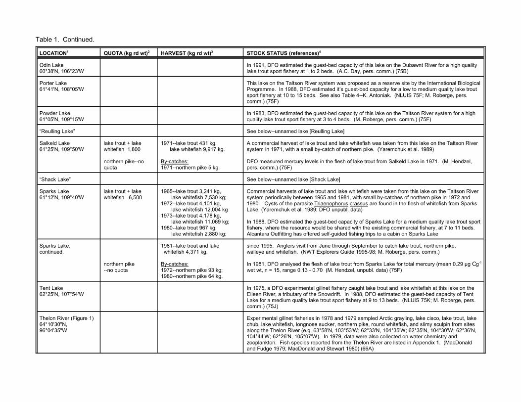
Table 1. Continued.
LOCATION1 QUOTA (kg rd wt)2 HARVEST (kg rd wt)3 STOCK STATUS (references)4
Odin Lake60°38'N, 106°23'W
In 1991, DFO estimated the guest-bed capacity of this lake on the Dubawnt River for a high qualitylake trout sport fishery at 1 to 2 beds. (A.C. Day, pers. comm.) (75B)
Porter Lake61°41'N, 108°05'W
This lake on the Taltson River system was proposed as a reserve site by the International BiologicalProgramme. In 1988, DFO estimated it’s guest-bed capacity for a low to medium quality lake troutsport fishery at 10 to 15 beds. See also Table 4--K. Antoniak. (NLUIS 75F; M. Roberge, pers.comm.) (75F)
Powder Lake61°05'N, 109°15'W
In 1983, DFO estimated the guest-bed capacity of this lake on the Taltson River system for a highquality lake trout sport fishery at 3 to 4 beds. (M. Roberge, pers. comm.) (75F)
“Reulling Lake” See below--unnamed lake [Reulling Lake]
Salkeld Lake61°25'N, 109°50'W
lake trout + lakewhitefish 1,800
northern pike--noquota
1971--lake trout 431 kg, lake whitefish 9,917 kg.
By-catches:1971--northern pike 5 kg.
A commercial harvest of lake trout and lake whitefish was taken from this lake on the Taltson Riversystem in 1971, with a small by-catch of northern pike. (Yaremchuk et al. 1989)
DFO measured mercury levels in the flesh of lake trout from Salkeld Lake in 1971. (M. Hendzel,pers. comm.) (75F)
“Shack Lake” See below--unnamed lake [Shack Lake]
Sparks Lake61°12'N, 109°40'W
lake trout + lakewhitefish 6,500
1965--lake trout 3,241 kg, lake whitefish 7,530 kg;1972--lake trout 4,101 kg, lake whitefish 12,004 kg1973--lake trout 4,178 kg, lake whitefish 11,069 kg;1980--lake trout 967 kg, lake whitefish 2,880 kg;
Commercial harvests of lake trout and lake whitefish were taken from this lake on the Taltson Riversystem periodically between 1965 and 1981, with small by-catches of northern pike in 1972 and1980. Cysts of the parasite Triaenophorus crassus are found in the flesh of whitefish from SparksLake. (Yaremchuk et al. 1989; DFO unpubl. data)
In 1988, DFO estimated the guest-bed capacity of Sparks Lake for a medium quality lake trout sportfishery, where the resource would be shared with the existing commercial fishery, at 7 to 11 beds. Alcantara Outfitting has offered self-guided fishing trips to a cabin on Sparks Lake
Sparks Lake,continued.
northern pike--no quota
1981--lake trout and lake whitefish 4,371 kg.
By-catches:1972--northern pike 93 kg;1980--northern pike 64 kg.
since 1995. Anglers visit from June through September to catch lake trout, northern pike,walleye and whitefish. (NWT Explorers Guide 1995-98; M. Roberge, pers. comm.)
In 1981, DFO analysed the flesh of lake trout from Sparks Lake for total mercury (mean 0.29 µg C g-1
wet wt, n = 15, range 0.13 - 0.70 (M. Hendzel, unpubl. data) (75F)
Tent Lake62°25'N, 107°54'W
In 1975, a DFO experimental gillnet fishery caught lake trout and lake whitefish at this lake on theEileen River, a tributary of the Snowdrift. In 1988, DFO estimated the guest-bed capacity of TentLake for a medium quality lake trout sport fishery at 9 to 13 beds. (NLUIS 75K; M. Roberge, pers.comm.) (75J)
Thelon River (Figure 1)64°10'30"N,96°04'35"W
Experimental gillnet fisheries in 1978 and 1979 sampled Arctic grayling, lake cisco, lake trout, lakechub, lake whitefish, longnose sucker, northern pike, round whitefish, and slimy sculpin from sitesalong the Thelon River (e.g. 63°58'N, 103°53'W; 62°33'N, 104°35'W; 62°35'N, 104°30'W; 62°36'N,104°44'W; 62°26'N, 105°07'W). In 1979, data were also collected on water chemistry andzooplankton. Fish species reported from the Thelon River are listed in Appendix 1. (MacDonaldand Fudge 1979; MacDonald and Stewart 1980) (66A)

Table 1. Continued.
LOCATION1 QUOTA (kg rd wt)2 HARVEST (kg rd wt)3 STOCK STATUS (references)4
Thoa River60°31'N, 109°47'W
In 1978, an experimental gillnet fishery (60°46'N, 106°48'W) sampled lake chub, lake cisco, lakewhitefish, and northern pike from this tributary of the Taltson River. (MacDonald and Fudge 1979)(75C)
Tourgis Lake64°41'N, 106°02'W
In 1977, an experimental gillnet fishery sampled longnose sucker and round whitefish from this lakeon the Baillie River system. (Stewart and MacDonald 1978) (76B)
Tronka Chua Lake61°30'N, 109°56'W
lake trout + lakewhitefish 1,900
1970---lake trout 2,518 kg, lake whitefish 8,233 kg.
Water from the impoundment created by the rockfill dam at the outlet of Nonacho Lake (seeLUTSEL K’E--Nonacho Lake) flows overland into Tronka Chua Lake when the reservoir water levelexceeds an elevation of 344.5 m (1050 feet). A commercial harvest of lake trout and lake whitefishwas taken from this lake on the Taltson River system in 1970. DFO measured mercury levels in theflesh of the lake trout. (Envirocon Limited et al. 1975; Yaremchuk et al. 1989; M. Hendzel, pers.comm.) (75F)
Turner Lake64°05'N, 104°45'W
lake trout + lakewhitefish--no quota
1967--lake trout 794 kg, lake whitefish 1,975 kg;1973--lake trout 773 kg, lake whitefish 702 kg.
Commercial harvests of lake trout and lake whitefish were taken from this lake on the Thelon Riversystem in 1967 and 1973. (Yaremchuk et al. 1989) (75A)
Tyrrell Lake63°15'N, 105°28'W
In 1978, an experimental gillnet fishery sampled lake cisco, lake trout, and round whitefish from thislake on the Thelon River system. (MacDonald and Fudge 1979) (75P)
unnamed lake[Lac Brulé]60°45'N, 106°07'W
In 1978, an experimental gillnet fishery sampled lake chub, lake trout, lake whitefish, longnosesucker, and northern pike from this lake on the Dubawnt River system. In 1991, DFO estimated theguest-bed capacity of Lac Brulé for a high quality lake trout sport fishery at 1 bed. (MacDonald andFudge 1979; A.C. Day, pers. comm.) (75B)
unnamed lake[Reulling Lake]61°22'N, 109°33'W
lake trout + lakewhitefish 1,900
1971--lake trout 5,321 kg, lake whitefish 2,843 kg.
A commercial harvest of lake trout and lake whitefish was taken from this lake on the Taltson Riversystem in 1971. DFO measured mercury levels in the flesh of the lake trout. (Yaremchuk et al.1989; M. Hendzel, pers. comm.) (75F)
unnamed lake[Shack Lake]60°29'N, 109°32'W
lake trout + lakewhitefish 600
This lake on the Taltson River system has a commercial harvest quota but no record of commercialharvest. (75C)
unnamed lake[West Hjalmar Lake]61°28'N, 109°35'W
lake trout + lakewhitefish 5,000
1970--lake trout 1,628 kg, lake whitefish 1,634 kg;1971--lake trout 391 kg, lake whitefish 315 kg;1977--lake trout and lake whitefish 9,917 kg.
Commercial harvests of lake trout and lake whitefish were taken from this lake on the Taltson Riversystem in 1970, 1971, and 1977. (Yaremchuk et al. 1989) (75F)
unnamed lake61°34'N, 102°12'W
In 1978, an experimental gillnet fishery sampled lake whitefish and longnose sucker from this lakeon the Kamilukuak river, a tributary of Dubawnt Lake. (MacDonald and Fudge 1979) (65E)
unnamed lake64°33'N, 104°23'W
In 1977, an experimental gillnet fishery sampled lake cisco and lake trout at this lake on the BaillieRiver. (Stewart and MacDonald 1978; NLUIS 76A) (76A)

ke trout, lake whitefish, and northern pike from this. In 1984, DFO indicated that Vandyck Lake was tootablishment. (DFO 1994, 1995; B. Wong, pers. comm.)
ke]
lake whitefish and northern pike at this lake on theUIS 75C) (75C)
lake whitefish and northern pike at this lake on theUIS 75C) (75C)
iated northern Saskatchewan communities havee southeastern portion of the South Slave area. (Bone
pled lake chub, lake trout, lake whitefish, and northernstem. Trappers from Black Lake Saskatchewan winter Ltd.’s North of Sixty Camps (Table 2) on Obre Lakeake (see INLAND WATERBODIES--Obre Lake). Ine managed using a quota on the lake trout harvest of. The intent of this recommendation was to limit thelodge to optimize the size of its operation. It would beilable harvest among its guests. (MacDonald andmm.) (75A)
pled lake cisco, lake trout, northern pike, and roundr system. Residents of Stony Rapids, Saskatchewanhe present extent of this fishery is unknown. In 1988,yd Lake for a high quality lake trout sport fishery at 5 toIS 65E; M. Roberge, pers. comm.) (65E) /SR
pled lake cisco, lake trout, and lake whitefish from thisn River. Trappers from Black Lake and Fond du Lac,t Lake area. The extent of any subsistence fishery isUIS 75H) (75H)
pled lake cisco, lake trout, lake whitefish, longnose this lake on the Dubawnt River system. Trappers from, winter in the area. The extent of any subsistence the guest-bed capacity of Firedrake Lake for a high
. (MacDonald and Fudge 1979; NLUIS 75H; D. Pike,
Table 1. Continued.
LOCATION1 QUOTA (kg rd wt)2 HARVEST (kg rd wt)3 STOCK STATUS (references)4
Vandyck Lake60°13'N, 109°28'N
lake trout + lakewhitefish 1,200
1992--lake trout 590 kg, lake whitefish 363 kg, northern pike 91 kg;1993--NF.
In 1992, an experimental fishery sampled laheadwater lake on the Taltson River systemsmall to support a proposed sport fishing es(75C)
“West Hjalmar Lake” See above--unnamed lake [West Hjalmar La
Whirlwind Lake60°15'N, 108°40'W
In 1975, a DFO experimental fishery caughtAbitau River, a tributary of the Taltson. (NL
Wren Lake60°20'N, 108°42'W
In 1975, a DFO experimental fishery caughtAbitau River, a tributary of the Taltson. (NL
BLACK LAKE and STONY RAPIDS, SASKATCHEWAN Chipewyan residents of these closely assoctraditionally trapped, hunted, and fished in thet al. 1973; Smith 1981)
Anaunethad Lake60°55'N, 104°25'W
In 1978, an experimental gillnet fishery sampike from this lake on the Dubawnt River syin the Anaunethad Lake area. Conservatoryoperates an outpost camp on Anaunethad L1994, DFO recommended that the fishery b1,000 fish, rather than assigning guest bedsannual lake trout harvest while allowing the the lodge’s responsibility to partition the avaFudge 1979; NLUIS 75H; A.C. Day, pers. co
Boyd Lake61°30'N, 103°23'W
In 1978, an experimental gillnet fishery samwhitefish from this lake on the Dubawnt Rivehave fished for subsistence at Boyd Lake. TDFO estimated the guest-bed capacity of Bo10 beds. (MacDonald and Fudge 1979; NLU
Damant Lake61°45'N, 105°05'W
In 1978, an experimental gillnet fishery samlake on the Elk River, a tributary of the TheloSaskatchewan, have wintered in the Damanunknown. (MacDonald and Fudge 1979; NL
Firedrake Lake61°25'N, 104°30'W
In 1978, an experimental gillnet fishery samsucker, northern pike, and slimy sculpin fromBlack Lake and Fond du Lac, Saskatchewanfishery is unknown. In 1991, DFO estimatedquality lake trout sport fishery at 4 to 8 bedspers. comm.) (75H)
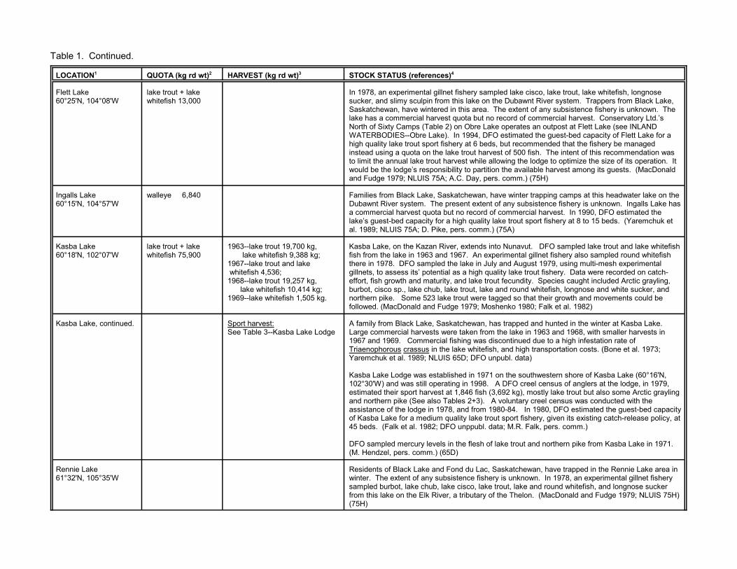
Table 1. Continued.
LOCATION1 QUOTA (kg rd wt)2 HARVEST (kg rd wt)3 STOCK STATUS (references)4
Flett Lake60°25'N, 104°08'W
lake trout + lakewhitefish 13,000
In 1978, an experimental gillnet fishery sampled lake cisco, lake trout, lake whitefish, longnosesucker, and slimy sculpin from this lake on the Dubawnt River system. Trappers from Black Lake,Saskatchewan, have wintered in this area. The extent of any subsistence fishery is unknown. Thelake has a commercial harvest quota but no record of commercial harvest. Conservatory Ltd.’sNorth of Sixty Camps (Table 2) on Obre Lake operates an outpost at Flett Lake (see INLANDWATERBODIES--Obre Lake). In 1994, DFO estimated the guest-bed capacity of Flett Lake for ahigh quality lake trout sport fishery at 6 beds, but recommended that the fishery be managedinstead using a quota on the lake trout harvest of 500 fish. The intent of this recommendation wasto limit the annual lake trout harvest while allowing the lodge to optimize the size of its operation. Itwould be the lodge’s responsibility to partition the available harvest among its guests. (MacDonaldand Fudge 1979; NLUIS 75A; A.C. Day, pers. comm.) (75H)
Ingalls Lake60°15'N, 104°57'W
walleye 6,840 Families from Black Lake, Saskatchewan, have winter trapping camps at this headwater lake on theDubawnt River system. The present extent of any subsistence fishery is unknown. Ingalls Lake hasa commercial harvest quota but no record of commercial harvest. In 1990, DFO estimated thelake’s guest-bed capacity for a high quality lake trout sport fishery at 8 to 15 beds. (Yaremchuk etal. 1989; NLUIS 75A; D. Pike, pers. comm.) (75A)
Kasba Lake60°18'N, 102°07'W
lake trout + lakewhitefish 75,900
1963--lake trout 19,700 kg, lake whitefish 9,388 kg;1967--lake trout and lake whitefish 4,536; 1968--lake trout 19,257 kg, lake whitefish 10,414 kg;1969--lake whitefish 1,505 kg.
Kasba Lake, on the Kazan River, extends into Nunavut. DFO sampled lake trout and lake whitefishfish from the lake in 1963 and 1967. An experimental gillnet fishery also sampled round whitefishthere in 1978. DFO sampled the lake in July and August 1979, using multi-mesh experimentalgillnets, to assess its’ potential as a high quality lake trout fishery. Data were recorded on catch-effort, fish growth and maturity, and lake trout fecundity. Species caught included Arctic grayling,burbot, cisco sp., lake chub, lake trout, lake and round whitefish, longnose and white sucker, andnorthern pike. Some 523 lake trout were tagged so that their growth and movements could befollowed. (MacDonald and Fudge 1979; Moshenko 1980; Falk et al. 1982)
Kasba Lake, continued. Sport harvest:See Table 3--Kasba Lake Lodge
A family from Black Lake, Saskatchewan, has trapped and hunted in the winter at Kasba Lake. Large commercial harvests were taken from the lake in 1963 and 1968, with smaller harvests in1967 and 1969. Commercial fishing was discontinued due to a high infestation rate ofTriaenophorous crassus in the lake whitefish, and high transportation costs. (Bone et al. 1973;Yaremchuk et al. 1989; NLUIS 65D; DFO unpubl. data)
Kasba Lake Lodge was established in 1971 on the southwestern shore of Kasba Lake (60°16'N,102°30'W) and was still operating in 1998. A DFO creel census of anglers at the lodge, in 1979,estimated their sport harvest at 1,846 fish (3,692 kg), mostly lake trout but also some Arctic graylingand northern pike (See also Tables 2+3). A voluntary creel census was conducted with theassistance of the lodge in 1978, and from 1980-84. In 1980, DFO estimated the guest-bed capacityof Kasba Lake for a medium quality lake trout sport fishery, given its existing catch-release policy, at45 beds. (Falk et al. 1982; DFO unppubl. data; M.R. Falk, pers. comm.)
DFO sampled mercury levels in the flesh of lake trout and northern pike from Kasba Lake in 1971. (M. Hendzel, pers. comm.) (65D)
Rennie Lake61°32'N, 105°35'W
Residents of Black Lake and Fond du Lac, Saskatchewan, have trapped in the Rennie Lake area inwinter. The extent of any subsistence fishery is unknown. In 1978, an experimental gillnet fisherysampled burbot, lake chub, lake cisco, lake trout, lake and round whitefish, and longnose suckerfrom this lake on the Elk River, a tributary of the Thelon. (MacDonald and Fudge 1979; NLUIS 75H)(75H)

Table 1. Continued.
LOCATION1 QUOTA (kg rd wt)2 HARVEST (kg rd wt)3 STOCK STATUS (references)4
Selwyn Lake60°05'N, 104°25'W
lake trout + lakewhitefish 22,700
1975--lake trout and lake whitefish 1,089 kg.1976--lake trout and lake whitefish 23,587 kg.1977--lake trout and lake whitefish 5,897 kg.1979--lake trout and lake whitefish 1,089 kg;1988--NF.
In 1978, an experimental gillnet fishery sampled lake trout, lake whitefish, and longnose sucker fromthis transboundary, headwater lake on the Slave River system. A number of families fromSaskatchewan community of Black Lake have spent the winter trapping in the Selwyn Lake areaand some have lived there year-round. The extent of any subsistence fishery is unknown. SelwynLake has been fished commercially by residents of Black Lake. Commercial harvests of lake troutand lake whitefish were taken in 1975-77 and 1979. The lake was opened for commercial fishing in1988 but not fished. There have been one or more sport fishing lodges located at the south end ofSelwyn Lake, in Saskatchewan (Selwyn Lake Lodge 30 beds; outpost of Black Lake Lodge 8 beds)since at least the 1970's. At least one of these was in operation in 1997. In 1994, DFO estimatedthe guest bed capacity of the north end of Selwyn Lake, in the NWT, for a high quality lake troutsport fishery at 12 beds, provided the outpost proposed by Selwyn Lake Lodge voluntarily restrictsits lake trout harvest to 16 kg per angler. (Bone et al. 1973; MacDonald and Fudge 1979;Yaremchuk et al. 1989; DFO 1991; Saskatchewan Vacation Guide 1997; NLUIS 75A; A.C. Day andG. Low, pers. comm.) (75A)
Smalltree Lake61°00'W, 105°00'W
In 1978, an experimental fishery sampled lake trout, lake whitefish, and northern pike from this lakeon the Dubawnt River system. Families from Black Lake, Saskatchewan, have trapped in this areain the winter. The extent of any subsistence fishery is unknown. Morberg’s Smalltree Camp hasoffered sport fishing at Smalltree Lake (Table 2). (MacDonald and Fudge 1979; NLUIS 75H) (75H)
Snowbird Lake60°41'N, 102°56'W
1982 Sport harvest:--83 Arctic grayling (75 kg),--289 lake trout (666 kg),--110 northern pike (319 kg).
Snowbird Lake lies within the treeline on the Kazan River system. DFO sampled lake trout, lakewhitefish, and northern pike from Snowbird Lake in 1968. Of 300 lake whitefish examined, 50% hadcysts of the parasite Triaenoophorus crassus in their flesh. The infestation rate was 82 cysts per 45kg of flesh. In 1978, an experimental gillnet fishery sampled lake trout, lake whitefish, and slimysculpin from Snowbird Lake. DFO also surveyed Snowbird Lake in 1982, using multi-meshexperimental gillnets, to assess the lake’s potential as a high quality lake trout fishery. Data werecollected on catch-effort; fish growth and maturity; and the sport harvest. Fish species caughtincluded Arctic grayling, burbot, cisco sp., lake trout, lake and round whitefish, longnose and whitesucker, and northern pike, Lake trout (n = 135) were tagged so that their movements and growthcould be monitored. (Johnson 1976; MacDonald and Fudge 1979; Moshenko 1980; Roberge et al.1984; DFO unpubl. data)
Families from Black Lake, Saskatchewan, have fished for subsistence at Snowbird Lake in supportof winter hunting and trapping activities. The extent of this fishery is unknown. (Bone et al. 1973;NLUIS 65D)
Conservatory Ltd. North of Sixty Camps (Snowbird Lake Lodge) and Kasba Lake Lodge (SnowbirdLodge and Snowbird North) operate sport fishing outposts on Snowbird Lake (Table 2). In 1982,Snowbird Lake Lodge operated from 25 July to 3 September. During that period DFO conducted acomplete creel survey of all 78 guests (Table 3). In 1994, DFO estimated the sustainable harvestfor a high quality lake trout fishery at Snowbird Lake at 2,840 to 5,680 kg per year. This wastranslated to a guest-bed capacity 18 to 36 beds, provided lodges and outposts voluntarily restrictlake trout harvest to 16 kg per angler or 160 kg per guest bed per year. (Roberge et al. 1985; A.C.Day, pers. comm.) (65D)
DFO sampled mercury levels in the flesh of lake trout and northern pike from Snowbird Lake in1971. (M. Hendzel, pers. comm.) (65D)
Three Wives Lake61°08'N, 102°44'W
Residents of Stony Rapids, Saskatchewan, have fished for subsistence at this lake on theKamilkukuak River, a tributary of the Dubawnt. (NLUIS 65E) (65E)
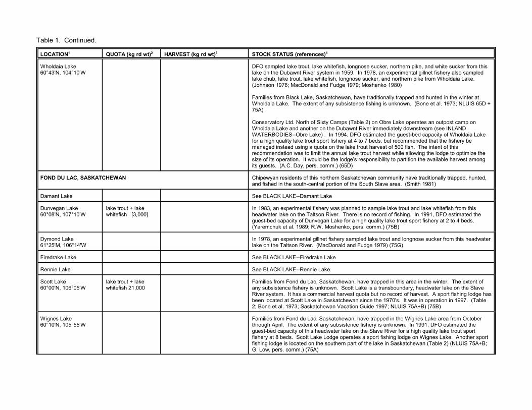
Table 1. Continued.
LOCATION1 QUOTA (kg rd wt)2 HARVEST (kg rd wt)3 STOCK STATUS (references)4
Wholdaia Lake60°43'N, 104°10'W
DFO sampled lake trout, lake whitefish, longnose sucker, northern pike, and white sucker from thislake on the Dubawnt River system in 1959. In 1978, an experimental gillnet fishery also sampledlake chub, lake trout, lake whitefish, longnose sucker, and northern pike from Wholdaia Lake. (Johnson 1976; MacDonald and Fudge 1979; Moshenko 1980)
Families from Black Lake, Saskatchewan, have traditionally trapped and hunted in the winter atWholdaia Lake. The extent of any subsistence fishing is unknown. (Bone et al. 1973; NLUIS 65D +75A)
Conservatory Ltd. North of Sixty Camps (Table 2) on Obre Lake operates an outpost camp onWholdaia Lake and another on the Dubawnt River immediately downstream (see INLANDWATERBODIES--Obre Lake) . In 1994, DFO estimated the guest-bed capacity of Wholdaia Lakefor a high quality lake trout sport fishery at 4 to 7 beds, but recommended that the fishery bemanaged instead using a quota on the lake trout harvest of 500 fish. The intent of thisrecommendation was to limit the annual lake trout harvest while allowing the lodge to optimize thesize of its operation. It would be the lodge’s responsibility to partition the available harvest amongits guests. (A.C. Day, pers. comm.) (65D)
FOND DU LAC, SASKATCHEWAN Chipewyan residents of this northern Saskatchewan community have traditionally trapped, hunted,and fished in the south-central portion of the South Slave area. (Smith 1981)
Damant Lake See BLACK LAKE--Damant Lake
Dunvegan Lake60°08'N, 107°10'W
lake trout + lakewhitefish [3,000]
In 1983, an experimental fishery was planned to sample lake trout and lake whitefish from thisheadwater lake on the Taltson River. There is no record of fishing. In 1991, DFO estimated theguest-bed capacity of Dunvegan Lake for a high quality lake trout sport fishery at 2 to 4 beds. (Yaremchuk et al. 1989; R.W. Moshenko, pers. comm.) (75B)
Dymond Lake61°25'M, 106°14'W
In 1978, an experimental gillnet fishery sampled lake trout and longnose sucker from this headwaterlake on the Taltson River. (MacDonald and Fudge 1979) (75G)
Firedrake Lake See BLACK LAKE--Firedrake Lake
Rennie Lake See BLACK LAKE--Rennie Lake
Scott Lake60°00'N, 106°05'W
lake trout + lakewhitefish 21,000
Families from Fond du Lac, Saskatchewan, have trapped in this area in the winter. The extent ofany subsistence fishery is unknown. Scott Lake is a transboundary, headwater lake on the SlaveRiver system. It has a commercial harvest quota but no record of harvest. A sport fishing lodge hasbeen located at Scott Lake in Saskatchewan since the 1970's. It was in operation in 1997. (Table2; Bone et al. 1973; Saskatchewan Vacation Guide 1997; NLUIS 75A+B) (75B)
Wignes Lake60°10'N, 105°55'W
Families from Fond du Lac, Saskatchewan, have trapped in the Wignes Lake area from Octoberthrough April. The extent of any subsistence fishery is unknown. In 1991, DFO estimated theguest-bed capacity of this headwater lake on the Slave River for a high quality lake trout sportfishery at 8 beds. Scott Lake Lodge operates a sport fishing lodge on Wignes Lake. Another sportfishing lodge is located on the southern part of the lake in Saskatchewan (Table 2) (NLUIS 75A+B;G. Low, pers. comm.) (75A)
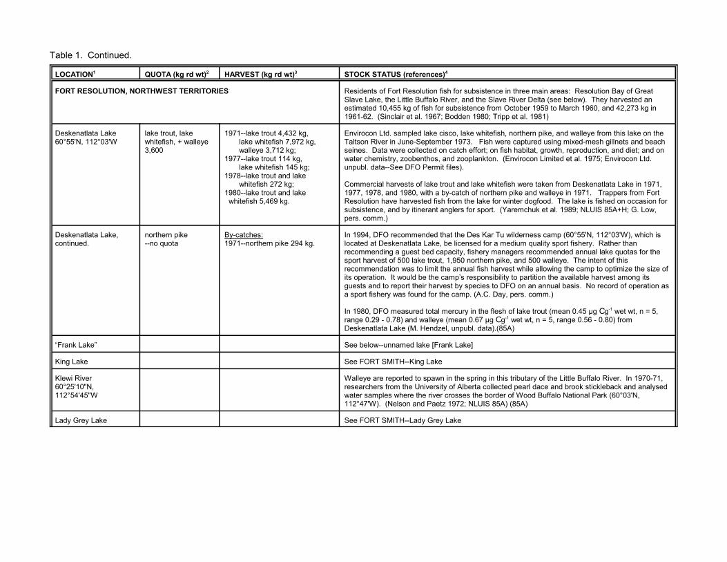
s)4
fish for subsistence in three main areas: Resolution Bay of GreatRiver, and the Slave River Delta (see below). They harvested anr subsistence from October 1959 to March 1960, and 42,273 kg in; Bodden 1980; Tripp et al. 1981)
cisco, lake whitefish, northern pike, and walleye from this lake on theber 1973. Fish were captured using mixed-mesh gillnets and beach
on catch effort; on fish habitat, growth, reproduction, and diet; and on and zooplankton. (Envirocon Limited et al. 1975; Envirocon Ltd.it files).
trout and lake whitefish were taken from Deskenatlata Lake in 1971, by-catch of northern pike and walleye in 1971. Trappers from Forth from the lake for winter dogfood. The lake is fished on occasion foranglers for sport. (Yaremchuk et al. 1989; NLUIS 85A+H; G. Low,
that the Des Kar Tu wilderness camp (60°55'N, 112°03'W), which is, be licensed for a medium quality sport fishery. Rather thanapacity, fishery managers recommended annual lake quotas for thet, 1,950 northern pike, and 500 walleye. The intent of thisthe annual fish harvest while allowing the camp to optimize the size of camp’s responsibility to partition the available harvest among itsvest by species to DFO on an annual basis. No record of operation asthe camp. (A.C. Day, pers. comm.)
mercury in the flesh of lake trout (mean 0.45 µg C g-1 wet wt, n = 5,e (mean 0.67 µg C g-1 wet wt, n = 5, range 0.56 - 0.80) fromel, unpubl. data).(85A)
rank Lake]
n in the spring in this tributary of the Little Buffalo River. In 1970-71,ity of Alberta collected pearl dace and brook stickleback and analysedr crosses the border of Wood Buffalo National Park (60°03'N,tz 1972; NLUIS 85A) (85A)
y Lake
Table 1. Continued.
LOCATION1 QUOTA (kg rd wt)2 HARVEST (kg rd wt)3 STOCK STATUS (reference
FORT RESOLUTION, NORTHWEST TERRITORIES Residents of Fort Resolution Slave Lake, the Little Buffalo estimated 10,455 kg of fish fo1961-62. (Sinclair et al. 1967
Deskenatlata Lake60°55'N, 112°03'W
lake trout, lakewhitefish, + walleye 3,600
1971--lake trout 4,432 kg, lake whitefish 7,972 kg, walleye 3,712 kg;1977--lake trout 114 kg, lake whitefish 145 kg;1978--lake trout and lake whitefish 272 kg;1980--lake trout and lake whitefish 5,469 kg.
Envirocon Ltd. sampled lake Taltson River in June-Septemseines. Data were collected water chemistry, zoobenthos,unpubl. data--See DFO Perm
Commercial harvests of lake 1977, 1978, and 1980, with aResolution have harvested fissubsistence, and by itinerant pers. comm.)
Deskenatlata Lake,continued.
northern pike--no quota
By-catches:1971--northern pike 294 kg.
In 1994, DFO recommended located at Deskenatlata Lakerecommending a guest bed csport harvest of 500 lake trourecommendation was to limit its operation. It would be theguests and to report their hara sport fishery was found for
In 1980, DFO measured totalrange 0.29 - 0.78) and walleyDeskenatlata Lake (M. Hendz
“Frank Lake” See below--unnamed lake [F
King Lake See FORT SMITH--King Lake
Klewi River60°25'10"N,112°54'45"W
Walleye are reported to spawresearchers from the Universwater samples where the rive112°47'W). (Nelson and Pae
Lady Grey Lake See FORT SMITH--Lady Gre

Table 1. Continued.
LOCATION1 QUOTA (kg rd wt)2 HARVEST (kg rd wt)3 STOCK STATUS (references)4
Little Buffalo River61°00'N, 113°45'W
Aboriginal food fishery at theriver mouth:
1975--1,000 lake whitefish [780 kg],1976--2,000 lake whitefish [1,560 kg],1977--18,800 lake whitefish [14,664 kg],1978--4,000 lake whitefish [3,120 kg],1979--3,600 lake whitefish [2,808 kg],1980--12,500 lake whitefish [9,750 kg],1981--5,000 lake whitefish [3,900 kg],1983--16,722 lake whitefish [18,394 kg],1994--9,034 lake whitefish [9,937 kg],
There is an important fall spawning migration of lake whitefish from Great Slave Lake into the LittleBuffalo River. Little Buffalo Falls, located about 145 km upstream from the mouth (60°03'N,112°42'W), is a natural barrier to fish movement. In 1970-71, researchers from the University ofAlberta sampled fish and water from the river above the falls where it crosses the border of WoodBuffalo National Park (60°03'N, 112°47'W). DFO studied the growth, reproduction, movements,and mortality of migratory whitefish in the lower reaches of the river using a fish weir, gillnets, andseines in atumn of 1975 (20 August to 7 October), 1993 (Sept.-Oct), and 1994 (Sept.-Oct.). Studies of post-spawning dispersal patterns were also undertaken in 1977, and fish were sampled in1979. The Little Buffalo River lake whitefish spawn in late September-October, and return to GreatSlave Lake after spawning before the shallow river freezes. Growth and mortality rates in 1993-94were similar to those from the 1975 and 1977 sampling. Tagged post-spawners range at least 70km from the river mouth. Fish species reported from the Little Buffalo River are listed in Appendix1. See also Table 4--M. Evans. (Nelson and Paetz 1972; Fuller 1955; Roberge et al. 1985; DFOunpubl. data; A.C. Day and G. Low, pers. comm.)
The Little Buffalo River lake whitefish are exploited mainly by the Aboriginal food fishery, and lightlyby the commercial fishery. DFO in cooperation with the Deninu Ku’e First Nation monitored theAboriginal food fishery at the river mouth each fall from 1975-81 and 1995-98. The fishery isconducted by families from nearby Fort Resolution, some of whom live or camp at the river mouth. Lake whitefish are caught using gillnets (102-114 mm stretched measure), mainly during the post-spawning run in late September and October in the lower 2.5 km of the river. Domestic gillnets byregulation are not to span more than two-thirds of the river.
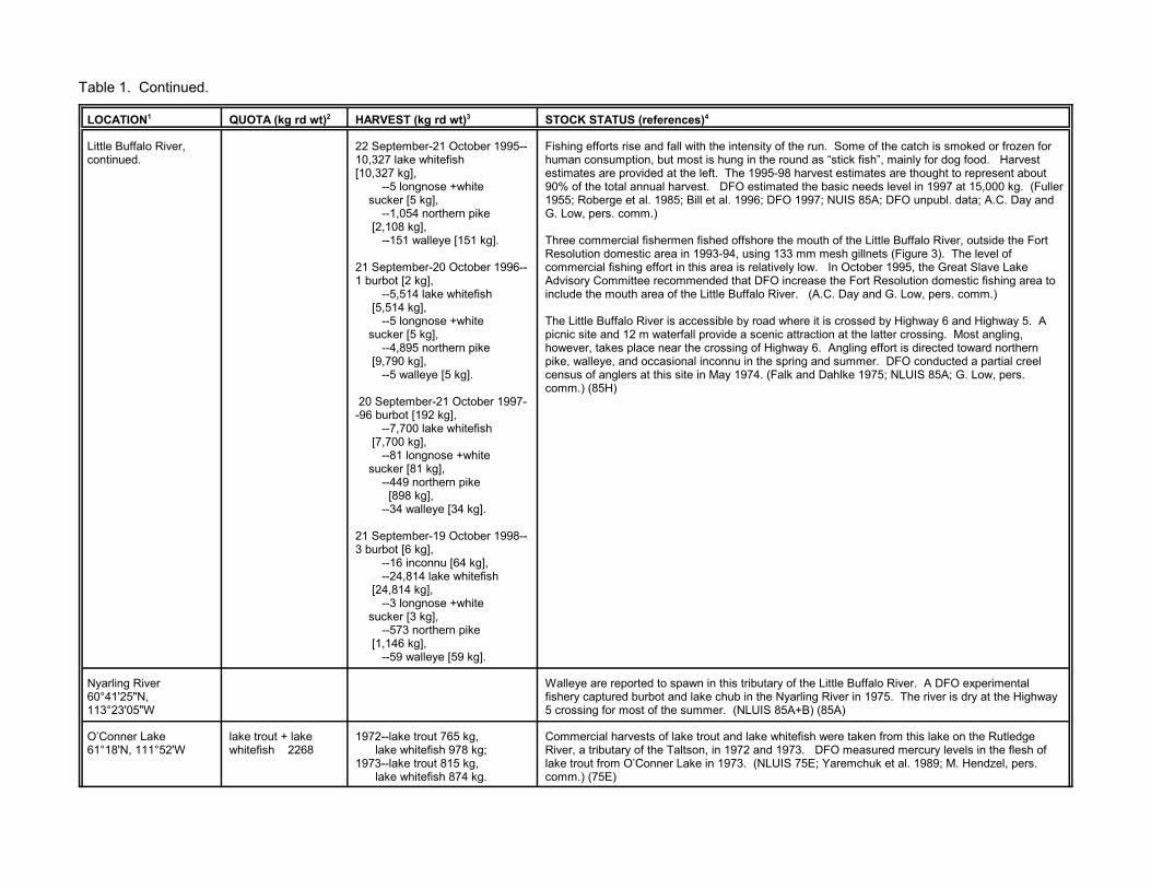
Table 1. Continued.
LOCATION1 QUOTA (kg rd wt)2 HARVEST (kg rd wt)3 STOCK STATUS (references)4
Little Buffalo River,continued.
22 September-21 October 1995--10,327 lake whitefish [10,327 kg], --5 longnose +white sucker [5 kg], --1,054 northern pike [2,108 kg], --151 walleye [151 kg].
21 September-20 October 1996--1 burbot [2 kg], --5,514 lake whitefish [5,514 kg], --5 longnose +white sucker [5 kg], --4,895 northern pike [9,790 kg], --5 walleye [5 kg].
20 September-21 October 1997--96 burbot [192 kg], --7,700 lake whitefish [7,700 kg], --81 longnose +white sucker [81 kg], --449 northern pike [898 kg], --34 walleye [34 kg].
21 September-19 October 1998--3 burbot [6 kg], --16 inconnu [64 kg], --24,814 lake whitefish [24,814 kg], --3 longnose +white sucker [3 kg], --573 northern pike [1,146 kg], --59 walleye [59 kg].
Fishing efforts rise and fall with the intensity of the run. Some of the catch is smoked or frozen forhuman consumption, but most is hung in the round as “stick fish”, mainly for dog food. Harvestestimates are provided at the left. The 1995-98 harvest estimates are thought to represent about90% of the total annual harvest. DFO estimated the basic needs level in 1997 at 15,000 kg. (Fuller1955; Roberge et al. 1985; Bill et al. 1996; DFO 1997; NUIS 85A; DFO unpubl. data; A.C. Day andG. Low, pers. comm.)
Three commercial fishermen fished offshore the mouth of the Little Buffalo River, outside the FortResolution domestic area in 1993-94, using 133 mm mesh gillnets (Figure 3). The level ofcommercial fishing effort in this area is relatively low. In October 1995, the Great Slave LakeAdvisory Committee recommended that DFO increase the Fort Resolution domestic fishing area toinclude the mouth area of the Little Buffalo River. (A.C. Day and G. Low, pers. comm.)
The Little Buffalo River is accessible by road where it is crossed by Highway 6 and Highway 5. Apicnic site and 12 m waterfall provide a scenic attraction at the latter crossing. Most angling,however, takes place near the crossing of Highway 6. Angling effort is directed toward northernpike, walleye, and occasional inconnu in the spring and summer. DFO conducted a partial creelcensus of anglers at this site in May 1974. (Falk and Dahlke 1975; NLUIS 85A; G. Low, pers.comm.) (85H)
Nyarling River60°41'25"N,113°23'05"W
Walleye are reported to spawn in this tributary of the Little Buffalo River. A DFO experimentalfishery captured burbot and lake chub in the Nyarling River in 1975. The river is dry at the Highway5 crossing for most of the summer. (NLUIS 85A+B) (85A)
O’Conner Lake61°18'N, 111°52'W
lake trout + lakewhitefish 2268
1972--lake trout 765 kg, lake whitefish 978 kg;1973--lake trout 815 kg, lake whitefish 874 kg.
Commercial harvests of lake trout and lake whitefish were taken from this lake on the RutledgeRiver, a tributary of the Taltson, in 1972 and 1973. DFO measured mercury levels in the flesh oflake trout from O’Conner Lake in 1973. (NLUIS 75E; Yaremchuk et al. 1989; M. Hendzel, pers.comm.) (75E)

Table 1. Continued.
LOCATION1 QUOTA (kg rd wt)2 HARVEST (kg rd wt)3 STOCK STATUS (references)4
“Paulette Creek” See below--unnamed creek [Paulette Creek]
Rutledge Lake See LUTSEL K’E--Rutledge Lake
Slave River Delta61°15'N, 113°30'W
Subsistence harvest:1976--burbot 6,546 kg, inconnu 1,475 kg, lake whitefish 1,783 kg, northern pike 1,478 kg, longnose sucker 1,653 kg;1977--burbot 8,624 kg, inconnu 3,085 kg, lake whitefish 2,175 kg, northern pike 1,874 kg, longnose sucker 1,522 kg.
21/9/83 to 8/11/83: --150 burbot (220 kg), --6 goldeye (2 kg), --30 inconnu (239 kg), --26 lake whitefish (29 kg), --44 northern pike (132 kg), --10 suckers (13 kg), --11 walleye (11 kg).
The Slave River Delta is one of three major river deltas in the Mackenzie River system. It is locatedon the south shore of Great Slave Lake immediately northeast of Fort Resolution, NT. Between1978 and 1981, the Mackenzie River Basin Committee studied the formation, hydrology, waterquality, and biota of the Slave River Delta. These studies were designed to provide informationuseful for evaluating the delta’s sensitivity to potential developments upstream and its importance todomestic and commercial fisheries elsewhere. The delta consists of the Resdelta Channel--whichcarries 86-90% of the flow and sediment; the East, Middle and West channels; and a number ofminor channels. Water level fluctuations of up to 3 m occur between spring high water and fall lowwater conditions, and the timing of break-up and the magnitude of flooding associated with icejamming can vary considerably. The delta is actively advancing. Hydrology and sedimentation arekey factors controlling the biological productivity of the delta. Twenty-three fish species were takenin the delta using multi mesh gillnets, beach seines, set lines, fish traps, and drift nets (seeAppendix 1). Data were collected on catch effort and on fish growth, reproduction, diet, movements(2,639 fish tagged), and habitat preferences. Northern pike, lake chub, emerald shiners, flatheadchub, and trout perch are abundant in the delta throughout the open water period. The delta is animportant corridor for the passage of large numbers of fish to their preferred spawning habitatsfurther upstream. Fish that migrate through the delta include inconnu, lake whitefish, and probablyspoonhead sculpin (see FORT SMITH--Salt River; FORT SMITH--Slave River). As adults these fishdo not feed or spawn in the delta but, instead, migrate through the delta to spawning and feedingareas located elsewhere. Goldeye, longnose suckers and walleye also spawn elsewhere but thenreturn to the delta to feed for most of the open water period. A goldeye tagged at the Peace-Athabasca Delta in 1976 was recaptured in the Slave River Delta in 1979. Walleye tagged in thedelta have been recaptured in the Simpson Islands area of Great Slave Lake, in the Slave River atFort Smith, and in the Salt River. The Resdelta Channel provides critical spawning habitat for largenumbers of burbot (November-December) and cisco (mid-October to mid-November), and rearinghabitat for young-of-the-year goldeye, lake whitefish, and spoonhead sculpin. The East, Middle,Steamboat, and Nagel channels are important feeding and rearing areas for smaller forage fishspecies and young-of-the-year burbot, flathead chub, longnose sucker, and northern pike. Shallow,well-vegetated shorelines are the habitat preferred by the fishes during the open water period. Lowcatches in January to March suggest that fishes overwinter primarily outside the delta. Upstreamreservoir development for hydro-electric projects could adversely affect the ecology of the delta See also Table 4--M. Evans. (Fuller 1955; Mackenzie River Basin Committee 1981a; Tripp et al.1981; English et al. 1996)

Table 1. Continued.
LOCATION1 QUOTA (kg rd wt)2 HARVEST (kg rd wt)3 STOCK STATUS (references)4
Slave River Delta,continued.
Aboriginal residents of Fort Resolution have traditionally harvested fish from the Slave River delta. Fishing areas are distributed throughout the delta and often associated with family camps in thevicinity. Each one has a history of past use by a particular family that is respected by otherharvesters. A survey of 102 of the 103 households in the community was conducted from July 1975to June 1977. Estimates of the 1976 (July 1975-June 1976) and 1977 (July 1976-June 1977)harvests are shown here. Burbot were taken in large numbers in the delta channels from lateOctober until mid-December. Fishing was conducted through the ice using set lines or shortgillnets. The eggs. liver and flesh are prized for human consumption. In the past, the Aboriginalfood fishery caught lake trout on lines set through the ice of the outer delta near the channel outlets. No trout were caught during the study and no effort to set lines was observed. Lake whitefish arethe most prized fish in the Slave Delta. Some were harvested in shallow waters of the outer deltajust after spring break-up, but the majority were harvested using gillnets as they migrated up theSlave River in September and October (see also FORT SMITH--Slave River). Longnose suckerwere numerous in the outer delta shortly after break-up, in mid-May to mid-June, but production wasshort-lived as the numbers declined and fishing activities were moved out into Resolution Bay. Theywere also harvested for winter dog food during the fall run. Northern pike were caught year-round,but were more common in catches during the spring high water period. Those caught by anglingwere eaten fresh, while those caught in nets were used for dog food. Inconnu were harvested inthe delta in conjunction with the whitefish run. Their oily flesh is highly prized for dogfood. Walleyeare rarely taken in the Slave Delta, About 30% of the burbot, 40% of the inconnu, 50% of the lakewhitefish, 10% of the longnose sucker, and 40% of the northern pike caught are used for humanconsumption. Depending upon the species, the fish are eaten fresh or are dried, smoked, or frozenfor future meals. The rest are frozen or dried on sticks for dog food. (Bodden 1981; G. Low, pers.comm.)
The fall 1983 harvest estimates are partial estimates based on daily counts kept by the threefishermen who fished regularly in the delta. (RL&L/EMA Slave River Joint Venture 1985) (85H)
Taltson Lake61°30'N, 110°15'W
lake trout + lakewhitefish 4,600
Inconnu + walleye--no quota.
1970--lake trout 10,360 kg, lake whitefish 21,806 kg;1980--lake whitefish 15 kg.
By-catches:1970--inconnu 25 kg; walleye 15 kg;1980--walleye 877 g.
Taltson Lake is downstream from the reservoir created for the Twin Gorges hydro-electric station byimpounding the flow of the Taltson River at the outlet of Nonacho Lake (see LUTSEL K’E--NonachoLake). Flow in the river has been altered by the impoundment such that the lake level typically risesto about 0.3 m above its natural level in the spring and falls 0.5 m below its natural level in thesummer and fall. Envirocon Ltd. sampled lake cisco, lake trout, and lake whitefish from TaltsonLake in June-September 1973. Fish were captured using mixed-mesh gillnets and beach seines. Data were collected on catch effort; on fish habitat, growth, reproduction, and diet; and on waterchemistry, zoobenthos, and zooplankton. (Envirocon Limited et al. 1975; Envirocon Pacific Limited1986; Envirocon Ltd. unpubl. data--See DFO Permit files).
Commercial harvests of lake trout and lake whitefish were taken from Taltson Lake in 1970 and1980, with small by-catches of inconnu in 1970, and walleye in both years. DFO measured mercurylevels in the flesh of lake trout from Taltson Lake in 1970. Cysts of the parasite Triaenophoruscrassus are common in the flesh of whitefish from the Lake. (Envirocon Pacific Limited 1986;Yaremchuk et al. 1989; DFO unpubl. data; M. Hendzel, pers. comm.)
Taltson Lake,continued.
Hanging Ice Fishing Camp operates a tent-frame outpost camp on Taltson Lake. In 1998, Eagle’sNest Lodge also began sport fishing operations at the lake (Table 2).
In 1980, DFO analysed the flesh of walleye from Taltson Lake for total mercury (mean 0.32 µg C g-1
wet wt, n = 16, range 0.21 - 0.81) (M. Hendzel, unpubl. data) (75E)

Table 1. Continued.
LOCATION1 QUOTA (kg rd wt)2 HARVEST (kg rd wt)3 STOCK STATUS (references)4
Taltson River61°24'W, 112°45W
walleye 11,400[mouth to theconfluence of theRat River]
1967--walleye 1,658 kg;1968--walleye 518 kg;1969--walleye 918 kg;1970--walleye 2,112 kg;1975--walleye 64 kg;1980--walleye 870 kg;1982--northern pike 631 kg;1983--walleye 843 kg;1984--walleye 200 kg.
The Taltson River has been affected by hydroelectric development. This development consists ofthe 21 MW Twin Gorges hydroelectric generating station (60°25'N, 111°24'W) which has beenoperated by the Northern Canada Power Commission since 1964; a storage reservoir created in1968 by the impoundment of Nonacho, Gray (see LUTSEL K’E), and Hjalmar (see INLANDWATERBODIES) lakes; and the diversion of most of the flow from the Tanzin River (see below), atTanzin Lake, into the Charlotte River, a tributary of the Athabasca, where Eldorado Nuclear has tworun-of-the-river generating stations. The Twin Gorges generating station was built to provide powerto the Pine Point Mine but now provides power to Fort Smith, Fort Resolution, Hay River, andEnterprise. The level of water in the Twin Gorges Forebay is 8.2 to 8.6 m higher than it would be inthe river under natural conditions. Below Twin Gorges Dam, water levels in the 16 km stretch ofriver from Elsie Falls to Nende Rapids just above Tsu Lake can fluctuate by 0.6 m in a few hours. This is one of the main ongoing effects of the hydro project on the system. These fluctuations andperiods of low flow may adversely affect northern pike and walleye populations in that run of theriver. Further hydro-electric developments have been proposed which would see additionalgenerating stations built near the Twin Gorges facility, at Elsie Falls and Twin Gorges #2, and thecreation of additional storage capacity at Nonacho Lake. Terms of reference were prepared in 1994for studies to assess the impacts of the Taltson Hydro Development, but these studies have not yetbeen completed. (Envirocon Limited et. al. 1975; Envirocon Pacific Limited 1986; Taltson ImpactStudies Sub-Committee 1994; P. Helwig, pers. comm.).
In June 1972, DFO collected data on water chemistry, benthos, and fish in the Taltson River within 8km of the mouth. Lake whitefish, longnose and white sucker, ninespine stickleback, northern pike,and walleye were sampled for data on growth and reproduction. In 1977, an experimental fisherysampled lake whitefish, longnose and white sucker, northern pike, and walleye from the reach ofriver between Nende and Natla rapids. In 1978, an experimental gillnet fishery sampled lake chub,lake cisco, lake trout, lake whitefish, and longnose sucker from Dymond Lake (see FOND DU LAC)and an unnamed headwater lake on the Taltson River system (61°18'N, 106°16'W). (Falk andDahlke 1975; Bogdan 1977; MacDonald and Fudge 1979; K. Chang-Kue, unpubl. data)
Envirocon Ltd. used mixed-mesh gillnets, beach seines and dip nets to capture lake trout, lakewhitefish, longnose sucker, northern pike, white sucker, and walleye from the Taltson River in June,July and September 1973 and May, June and September 1985--lake cisco were also taken in 1973and Arctic grayling in 1985. Data were collected on catch effort; on fish habitat, growth,reproduction, diet, and parasites (1986 only); and on water chemistry, zoobenthos, and zooplankton. Much of the 1973 sampling was conducted at lakes on the Taltson River system, includingDeskenatlata, Taltson (see above), Tsu (see below), Benna Thy, King, Kozo, Lady Grey, Methleka(see FORT SMITH), Hjalmar (see INLAND WATERBODIES), Gray, and Nonacho (see LUTSELK’E). The 1985 sampling was conducted in the river itself
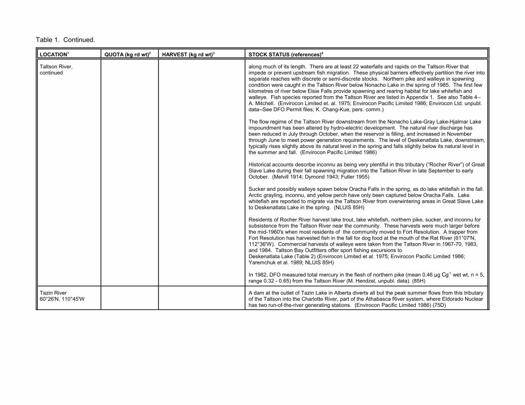
Table 1. Continued.
LOCATION1 QUOTA (kg rd wt)2 HARVEST (kg rd wt)3 STOCK STATUS (references)4
Taltson River,continued
along much of its length. There are at least 22 waterfalls and rapids on the Taltson River thatimpede or prevent upstream fish migration. These physical barriers effectively partition the river intoseparate reaches with discrete or semi-discrete stocks. Northern pike and walleye in spawningcondition were caught in the Taltson River below Nonacho Lake in the spring of 1985. The first fewkilometres of river below Elsie Falls provide spawning and rearing habitat for lake whitefish andwalleye. Fish species reported from the Taltson River are listed in Appendix 1. See also Table 4--A. Mitchell. (Envirocon Limited et. al. 1975; Envirocon Pacific Limited 1986; Envirocon Ltd. unpubl.data--See DFO Permit files; K. Chang-Kue, pers. comm.)
The flow regime of the Taltson River downstream from the Nonacho Lake-Gray Lake-Hjalmar Lakeimpoundment has been altered by hydro-electric development. The natural river discharge hasbeen reduced in July through October, when the reservoir is filling, and increased in Novemberthrough June to meet power generation requirements. The level of Deskenatlata Lake, downstream,typically rises slightly above its natural level in the spring and falls slightly below its natural level inthe summer and fall. (Envirocon Pacific Limited 1986)
Historical accounts describe inconnu as being very plentiful in this tributary (“Rocher River”) of GreatSlave Lake during their fall spawning migration into the Taltson RIver in late September to earlyOctober. (Melvill 1914; Dymond 1943; Fuller 1955)
Sucker and possibly walleye spawn below Oracha Falls in the spring, as do lake whitefish in the fall. Arctic grayling, inconnu, and yellow perch have only been captured below Oracha Falls. Lakewhitefish are reported to migrate via the Taltson River from overwintering areas in Great Slave Laketo Deskenatlata Lake in the spring. (NLUIS 85H)
Residents of Rocher River harvest lake trout, lake whitefish, northern pike, sucker, and inconnu forsubsistence from the Taltson River near the community. These harvests were much larger beforethe mid-1960's when most residents of the community moved to Fort Resolution. A trapper fromFort Resolution has harvested fish in the fall for dog food at the mouth of the Rat River (61°07'N,112°36'W). Commercial harvests of walleye were taken from the Taltson River in 1967-70, 1983,and 1984. Taltson Bay Outfitters offer sport fishing excursions toDeskenatlata Lake (Table 2) (Envirocon Limited et al. 1975; Envirocon Pacific Limited 1986;Yaremchuk et al. 1989; NLUIS 85H)
In 1982, DFO measured total mercury in the flesh of northern pike (mean 0.46 µg C g-1 wet wt, n = 5,range 0.32 - 0.65) from the Taltson River (M. Hendzel, unpubl. data). (85H)
Tazin River60°26'N, 110°45'W
A dam at the outlet of Tazin Lake in Alberta diverts all but the peak summer flows from this tributaryof the Taltson into the Charlotte River, part of the Athabasca River system, where Eldorado Nuclearhas two run-of-the-river generating stations. (Envirocon Pacific Limited 1986) (75D)
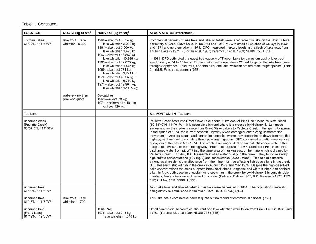
Table 1. Continued.
LOCATION1 QUOTA (kg rd wt)2 HARVEST (kg rd wt)3 STOCK STATUS (references)4
Thubun Lakes61°32'N, 111°55'W
lake trout + lakewhitefish 9,300
walleye + northernpike --no quota
1960--lake trout 7,654 kg, lake whitefish 2,238 kg;1961--lake trout 3,660 kg, lake whitefish 1,423 kg;1962--lake trout 16,857 kg, lake whitefish 10,666 kg;1963--lake trout 12,073 kg, lake whitefish 1,445 kg;1969--lake trout 784 kg, lake whitefish 3,721 kg;1970--lake trout 3,825 kg lake whitefish 6,710 kg;1971--lake trout 12,904 kg, lake whitefish 12,155 kg;
By-catches:1969--walleye 78 kg;1971--northern pike 101 kg, walleye 120 kg.
Commercial harvests of lake trout and lake whitefish were taken from this lake on the Thubun River,a tributary of Great Slave Lake, in 1960-63 and 1969-71, with small by-catches of walleye in 1969and 1971 and northern pike in 1971. DFO measured mercury levels in the flesh of lake trout fromThubun Lake in 1971. (Sinclair et al. 1967; Yaremchuk et al. 1989; NLUIS 75E + 85H)
In 1981, DFO estimated the guest-bed capacity of Thubun Lake for a medium quality lake troutsport fishery at 14 to 16 beds. Thubun Lake Lodge operates a 22 bed lodge on the lake from Junethrough September. Lake trout, northern pike, and lake whitefish are the main target species (Table2). (M.R. Falk, pers. comm.) (75E)
Tsu Lake See FORT SMITH--Tsu Lake
unnamed creek[Paulette Creek]60°57.5'N, 113°58'W
Paulette Creek flows into Great Slave Lake about 30 km east of Pine Point, near Paulette Island(60°58'40"N, 114°01'W). It is accessible by road where it is crossed by Highway 6. Longnosesucker and northern pike migrate from Great Slave Lake into Paulette Creek in the spring to spawn. In the spring of 1974, the culvert beneath Highway 6 was damaged, obstructing upstream fishmovements. Anglers caught and snared both species where they concentrated downstream of thehighway as they tried to complete their spawning migration. DFO conducted a partial creel censusof anglers at the site in May 1974. The creek is no longer blocked but fish still concentrate in thedeep pool downstream from the highway. Prior to its closure in 1987, Cominco’s Pine Point Minedischarged water from pit W17 into the large area of muskeg east of the mine which is drained byPaulette Creek. In 1976, B.C. Research studied water quality in the creek. They found relativelyhigh sulfate concentrations (830 mg/L) and conductance (2020 µmhos). This raised concernsamong local residents that discharge from the mine might be affecting fish populations in the creek. B.C. Research studied fish in the creek in August 1977 and May 1978. Despite the high dissolvedsolid concentrations the creek supports brook stickleback, longnose and white sucker, and northernpike. In May, both species of sucker were spawning in the creek below Highway 6 in considerablenumbers, few suckers were observed upstream. (Falk and Dahlke 1975; B.C. Research 1977, 1978a+b; G. Low, pers. comm.) (85B)
unnamed lake61°09'N, 111°40'W
Most lake trout and lake whitefish in this lake were harvested in 1964. The populations were stillbeing slowly re-established in the mid-1970's. (NLUIS 75E) (75E)
unnamed lake61°15'N, 111°59'W
lake trout + lakewhitefish 700
This lake has a commercial harvest quota but no record of commercial harvest. (75E)
unnamed lake[Frank Lake]61°19'N, 112°00'W
1968--NA;1978--lake trout 743 kg, lake whitefish 1,240 kg.
Small commercial harvests of lake trout and lake whitefish were taken from Frank Lake in 1968 and 1978. (Yaremchuk et al 1989; NLUIS 75E) (75E)

t and walleye was taken from this lake on theot have a commercial harvest quota. (NLUIS
60 kg of fish for subsistence in 1961-62; t al. 1967)
ple lake trout and lake whitefish from this lake
rd of commercial harvest. (75C)
lake trout and lake whitefish from this lake near
ated for the Twin Gorges hydro-electric stationtlet of Nonacho Lake (see LUTSEL K’E-- the impoundment such that the lake levele spring and falls 0.1 m below its natural levelcisco, lake trout, lake whitefish, longnosene-September 1973. Fish were capturedere collected on catch effort; on fish habitat,y, zoobenthos, and zooplankton. (Enviroconnvirocon Ltd. unpubl. data--See DFO Permit
rd of commercial harvest. (Yaremchuk et al.
lake whitefish from this lake near Fort Smith.
ple lake trout and lake whitefish from this lake91, DFO estimated the guest-bed capacity ofy at 1 bed. (Yaremchuk et al. 1989; R.W.
e Taltson, have a commercial harvest quota
a commercial harvest quota but no record ofitefish from Disappointment Lake in July 1995.
Table 1. Continued.
LOCATION1 QUOTA (kg rd wt)2 HARVEST (kg rd wt)3 STOCK STATUS (references)4
unnamed lake[Gullion Lake]61°28'N, 112°08'W
1967--lake trout 127 kg, walleye 164 kg.
A small experimental commercial harvest of lake trouThuban River system, in 1967. Gukkion Lake does n85H; Yaremchuk et al. 1989) (85H)
FORT SMITH, NORTHWEST TERRITORIES Residents of Fort Smith harvested an estimated 31,231,818 kg in 1963; and 86,364 kg in 1964. (Sinclair e
Beauvais Lake60°27'N, 105°31'W
lake trout + lakewhitefish [45]
In 1983, an experimental fishery was planned to samnear Fort Smith. (Yaremchuk et al. 1989) (75A)
Bedareh Lake60°19'N, 110°00'W
lake trout + lakewhitefish 2,000
This lake has a commercial harvest quota but no reco
Berens Lake60°23'N, 110°50'W
lake trout + lakewhitefish [200]
1989--lake trout 57 kg, lake whitefish 6 kg, northern pike 4 kg.
In March 1990, a DFO experimental fishery sampled Fort Smith. (McGowan et al. 1993) (75D)
Benna Thy Lake60°38'N, 110°33'W
lake trout + lakewhitefish 900
Benna Thy Lake is downstream from the reservoir creby impounding the flow of the Taltson River at the ouNonacho Lake). Flow in the river has been altered bytypically rises about 0.1 m above its natural level in thin the summer and fall. Envirocon Ltd. sampled lake sucker, and northern pike from Benna Thy Lake in Juusing mixed-mesh gillnets and beach seines. Data wgrowth, reproduction, and diet; and on water chemistrLimited et al. 1975; Envirocon Pacific Limited 1986; Efiles).
The lake has a commercial harvest quota but no reco1989) (75D)
Blackman Lake[Pete’s Lake]60°12'N, 111°10'W
lake whitefish [200] 1988--NF;1989--lake whitefish 250 kg, northern pike 5 kg, walleye 3 kg.
In March 1990, a DFO experimental fishery sampled (DFO 1991, 1992a; McGowan et al. 1993) (75D)
“Burnt Lake” See below--unnamed lake [Burnt Lake]
Carleton Lake60°17'N, 106°57'W
In 1983, an experimental fishery was planned to samnear Fort Smith. There is no record of fishing. In 19Carleton Lake for a high quality lake trout sport fisherMoshenko, pers. comm.) (75B)
Champagne Lakes60°38'N, 111°10'W
lake trout + lakewhitefish 300
These small lakes on the Knoth River, a tributary of thbut no record of commercial harvest. (75D)
Disappointment Lake60°05'N, 110°27'W
lake trout + lakewhitefish 1,400
This headwater lake on the Taltson River system hascommercial harvest. DFO sampled lake trout and wh(DFO unpubl. data) (75D)

Table 1. Continued.
LOCATION1 QUOTA (kg rd wt)2 HARVEST (kg rd wt)3 STOCK STATUS (references)4
Donovan Lake60°02'N, 111°11'W
Donovan Lake Outfitters have operated a tent-frame sport fishing camp for northern pike andwalleye at Donovan Lake (60°01'12"N, 111°09'13"W) since 1994. (NWT Explorers Guide 1994-98;S. Ransom, pers. comm.) (75D)
“Elbow Lake” See below--unnamed lake [Elbow Lake]
Fork Lake60°53'N, 111°05'W
lake trout + lakewhitefish 900
This headwater lake on the Knoth River, a tributary of the Taltson, has a commercial harvest quotabut no record of commercial harvest. DFO sampled lake trout and whitefish from Fork Lake in June1965. (DFO unpubl. data) (75D)
Gertrude Lake60°23'N, 111°21'W
lake trout + lakewhitefish 200
This small lake on Trudel Creek, a tributary of the Taltson River, has a commercial harvest quotabut no record of commercial harvest. (75D)
Hanging Ice Lake60°13'N, 110°55'W
lake trout + lakewhitefish 1,400
Residents of Fort Smith fish for subsistence at Hanging Ice Lake. This lake was opened forcommercial harvest in 1973, 1981 and 1982, but no harvest was reported (Yaremchuk et al. 1989;Bill et al. 1996; D. McGowan, pers. comm.) (75D)
High Level Lake60°50'N, 110°39'W
lake trout + lakewhitefish 700
Residents of Fort Smith fish for subsistence at this lake on the Taltson River system. The lake hasa commercial harvest quota but no record of commercial harvest. (Bill et al. 1996) (75D)
Hill Island Lake60°29'N, 109°50'W
In June 1963, a DFO experimental fishery sampled lake trout, whitefish, northern pike, and suckersfrom Hill Island Lake. The identity of the whitefish is unclear. They were reported as lake whitefish(Moshenko 1980) but a note with the original data indicates that they were round whitefish (DFOunpubl. data). Many of the whitefish and trout had cysts of the parasite Triaenophorus crassus intheir flesh. (Moshenko 1980; DFO unpubl. data)
In 1983, DFO estimated the guest-bed capacity of Hill Island Lake for a high quality lake trout sportfishery at 6 to 8 beds. Whitewood Lodge offered sport fishing at Hill Island Lake in the mid-1980's(Table 2) (M. Roberge, pers. comm.) (75C)
Hotel Lake60°25'N, 110°05'W
lake trout + lakewhitefish 1,000
This lake on the Taltson River system has a commercial harvest quota but no record of commercialharvest. (75D)
Indian Shack Lake60°40'N, 111°05'W
lake trout + lakewhitefish 500
This lake on the Knoth River, a tributary of the Taltson, has a commercial harvest quota but norecord of commercial harvest. (75D)
Jack Lake60°46'N, 111°08'W
lake trout + lakewhitefish 300
This lake on the Taltson River system has a commercial harvest quota but no record of commercialharvest. (75D)

Table 1. Continued.
LOCATION1 QUOTA (kg rd wt)2 HARVEST (kg rd wt)3 STOCK STATUS (references)4
King Lake61°05'N, 110°35'W
lake trout + lakewhitefish 3,000
King Lake is downstream from the reservoir created for the Twin Gorges hydro-electric station byimpounding the flow of the Taltson River at the outlet of Nonacho Lake (see LUTSEL K’E--NonachoLake). Flow in the river has been altered by the impoundment such that the lake level typically risesto about 0.15 m above its natural level in the spring and falls about 0.15 m below its natural level inthe summer and fall. (Envirocon Pacific Limited 1986)
Envirocon Ltd. sampled lake cisco, lake trout, lake whitefish, and northern pike from King Lake inJune-September 1973. Fish were captured using mixed-mesh gillnets and beach seines. Datawere collected on catch effort; on fish habitat, growth, reproduction, and diet; and on waterchemistry, zoobenthos, and zooplankton. (Envirocon Limited et al. 1975; Envirocon Ltd. unpubl.data--See DFO Permit files).
King Lake has a commercial harvest quota but no record of commercial harvest. In 1992, DFOestimated the lake’s guest bed capacity for a low quality lake trout sport fishery at 5 to 8 beds,provided that any lodge established on the lake restricts harvests to 16 kg per guest per year. (NLUIS 75E; A.C. Day and G. Low, pers. comm.) (75E)
Kozo Lake60°30'N, 110°58'W
Kozo Lake is downstream from the reservoir created for the Twin Gorges hydro-electric station byimpounding the flow of the Taltson River at the outlet of Nonacho Lake (see LUTSEL K’E--NonachoLake). Flow in the river has been altered by the impoundment such that the lake level typically risesabout 0.1 m above its natural level in the spring and falls 0.1 m below its natural level in the summerand fall. (Envirocon Pacific Limited 1986)
Envirocon Ltd. sampled lake cisco, lake trout, lake whitefish, longnose sucker, northern pike andwhite sucker from this lake on the Taltson River in June-September 1973. Fish were capturedusing mixed-mesh gillnets and beach seines. Data were collected on catch effort; on fish habitat,growth, reproduction, and diet; and on water chemistry, zoobenthos, and zooplankton. (EnviroconLimited et al. 1975; Envirocon Ltd. unpubl. data--See DFO Permit files). (75D)
Lady Grey Lake60°54'N, 110°32'W
Lady Grey Lake is downstream from the reservoir created for the Twin Gorges hydro-electric stationby impounding the flow of the Taltson River at the outlet of Nonacho Lake (see LUTSEL K’E--Nonacho Lake). Flow in the river has been altered by the impoundment such that the lake leveltypically rises to about 0.2 m above its natural level in the spring and falls 0.3 m below its naturallevel in the summer and fall. (Envirocon Pacific Limited 1986)
DFO experimental fisheries sampled lake whitefish from Lady Grey Lake in 1962 and 1965, and lake trout and northern pike in 1965. In 1972, DFO conducted a limnological survey of the lake. Data were collected on the water chemistry, phytoplankton, zooplankton, and zoobenthos of thelake. Fish were captured using multi-mesh experimental gillnets, seines, and rod and reel. Data onthe catch effort and on fish growth, reproduction, diet, and parasites were reported. Lake trout, lakewhitefish, longnose sucker, and northern pike were sampled. Spottail shiner and ninespinestickleback were captured in beach seines, and cisco and sculpin were identified from fishstomachs. Parasite cysts, likely Triaenophorus crassus, were common in the flesh of the lakewhitefish. A sport fishing lodge was located on the lake in the 1960's. (Falk 1979; Moshenko 1980;DFO unpubl. data)

Table 1. Continued.
LOCATION1 QUOTA (kg rd wt)2 HARVEST (kg rd wt)3 STOCK STATUS (references)4
Lady Grey Lake,continued.
Envirocon Ltd. sampled lake cisco, lake trout, and lake whitefish from Lady Grey Lake in June-September 1973. Fish were captured using mixed-mesh gillnets and beach seines. Data werecollected on catch effort; on fish habitat, growth, reproduction, and diet; and on water chemistry,zoobenthos, and zooplankton. (Envirocon Limited et al. 1975; Envirocon Ltd. unpubl. data--SeeDFO Permit files).
Lady Grey Lake Outfitters operate a sport fishing cabin establishment at Lady Grey Lake (Table 2). Itinerant anglers sometimes fish for Arctic grayling below the rapids at the lake outlet. (NLUIS 75D)(75D)
Largepike Lake60°05'N, 110°20'W
lake trout + lakewhitefish 1900
This headwater lake on the Tethul River, a tributary of the Taltson, has a commercial harvest quotabut no record of commercial harvest. Largepike Lake Camp offers sport fishing, touring andecoventures from their lodge on Largepike Lake (Table 2). (Yaremchuk et al. 1989) (75D)
Leland Lakes60°00'N, 110°59'W
lake trout + lakewhitefish 600
1981--lake whitefish 136 kg. A small commercial harvest of lake whitefish was taken from these headwater lakes on the SlaveRiver system, in 1981. In 1984, a tourist establishment was proposed for this lake which DFOindicated was too small to support a sport fishing establishment. (Yaremchuk et al. 1989; B. Wong,pers. comm.)
In 1989 and 1990, DFO analysed the flesh of whitefish, northern pike, and walleye from Leland Lakefor total mercury (µg C g-1 wet wt). The 1989 results (whitefish: mean 0.11, n=10, range 0.05 - 0.16;northern pike: mean 0.34, n=22, range 0.16 - 0.59; walleye: mean 0.46, n=9, range 0.25 - 0.73)were closely similar to those in 1990 (whitefish: mean 0.12, n=10, range 0.06 - 0.23; northern pike: mean 0.35, n=10, range 0.26 - 0.43; walleye: mean 0.46, n=10, range 0.34 - 0.58). (M. Hendzel,unpubl. data) (75D)
Little Buffalo River See FORT RESOLUTION--Little Buffalo Lake
MacInnis Lake61°21'N, 110°12'W
lake trout + lakewhitefish 2,300
1971--lake trout 5,654 kg, lake whitefish 9,507 kg.
A commercial harvest of lake trout and lake whitefish was taken from MacInnis Lake in 1971. DFO measured mercury levels in the flesh of lake trout from the lake in 1971. In 1986, DFOestimated the guest-bed capacity of MacInnis Lake for a medium quality lake trout sport fishery at10 to 14 beds, given that the resource may be shared with the commercial fishery. (Yaremchuk etal. 1989; M. Hendzel, pers. comm.; D. Moshenko, pers. comm.) (75E)
Methleka Lake60°28'N, 111°12'W
Envirocon Ltd. sampled lake cisco, lake trout, lake whitefish, and northern pike from this lake on theTaltson River in June-September 1973. Fish were captured using mixed-mesh gillnets and beachseines. Data were collected on catch effort; on fish habitat, growth, reproduction, and diet; and onwater chemistry, zoobenthos, and zooplankton. (Envirocon Limited et al. 1975; Envirocon Ltd.unpubl. data--See DFO Permit files). (75D)
Mistigi Lake60°26'N, 111°47'W
lake trout + lakewhitefish 500
In June 1965, a DFO experimental fishery sampled lake trout and lake whitefish from Mistigi Lake. The lake has a commercial harvest quota but no record of commercial harvest. (Yaremchuk et al.1989; DFO unpubl. data) (75D)
Naylor Lakes60°34'N, 111°27'W
lake trout + lakewhitefish 300
This lake has a commercial harvest quota but no record of commercial harvest. (Yaremchuk et al.1989) (75D)
Nonacho Lake See LUTSEL K’E--Nonacho Lake

Table 1. Continued.
LOCATION1 QUOTA (kg rd wt)2 HARVEST (kg rd wt)3 STOCK STATUS (references)4
Oulton Lake60°47'N, 111°20'W
lake trout + lakewhitefish 1,000
Residents of Fort Smith fish for subsistence at this lake on the Taltson River system. Oulton Lakehas a commercial harvest quota but no record of commercial harvest. (Bill et al. 1996) (75D)
Piers Lake60°20'N, 111°09'W
lake trout + lakewhitefish 1,000
1975--lake trout and lake whitefish 220 kg;1988-93--NF.
A commercial harvest of lake trout and lake whitefish was taken from this lake on the Taltson Riversystem in 1975. The quota was opened for fishing but not fished in 1988-93. (Yaremchuk et al.1989; DFO 1991, 1992a+b, 1993, 1994, 1995) (75D)
Pilot Lake60°17'N, 111°00'W
This isolated lake lies in the depression caused by a meteorite impact. It was identified forconsideration as an ecological reserve by the International Biological Programme. Residents of FortSmith fish for subsistence at Pilot Lake which was identified as a “good trout lake”. Pilot LakeCabins operates a sport fishing camp at Pilot Lake (Table 2). (Bill et al. 1996; NLUIS 75D) (75D)
Robinson Lake60°48'N, 110°55'W
lake trout + lakewhitefish 600
Residents of Fort Smith fish for subsistence at this lake on the Robinson River, a tributary of theKnoth River which flows into the Taltson. Robinson Lake has a commercial harvest quota but norecord of commercial harvest. (Bill et al. 1996) (75D)
Salt River60°06'30"N,112°14'05"W
Open water domestic fishery atSalt River mouth:
1983--130 inconnu (923 kg), --1,000 lake whitefish (1,000 kg), --4 northern pike (5 kg);
1984--10 goldeye (5 kg), --150 inconnu (772 kg), --80 lake whitefish (74kg), --10 northern pike (18 kg), --15 suckers (20 kg), --15 walleye (18 kg).
In 1970-71, researchers from the University of Alberta sampled fish and water at 5 sites on the SaltRiver (NWT: 60°05'N, 112°15'W; 60°01'N, 112°21'W; 59°58'N, 112°24'W; ALBERTA: 59°57'N,112°17'N, 59°49'N, 111°57'W). This tributary of the Slave River straddles the Northwest Territories-Alberta border and the border of Wood Buffalo National Park. The Salt River is exceptionally highin total dissolved solids, except in the extreme headwaters, with the major ions being sodium andchloride. Some of its tributaries are springs which have salinities about 9 times that of sea water. Fish species reported from the Salt River are listed in Appendix 1, under the heading of “SlaveRiver” where they are identified by a footnote. Pine Lake (59°33'N, 112°15'W), at the head of theSalt River system was stocked with rainbow trout fry in 1958, 1959, and 1971. In 1959, rainbowtrout were also planted in the Salt River. There was no evidence of reproduction by the rainbowtrout when the system was sampled in 1970-71. (Nelson and Paetz 1972)
Aquatic Environments Limited conducted a short-term fishery survey of the lower reaches of the SaltRiver in the spring of 1979 as part of the Mackenzie River Basins Committee studies of the SlaveRiver. Fish were captured using multi-mesh gillnets and beach seines. Data were collected oncatch effort and on fish growth, reproduction, diet, movements (769 fish tagged), and habitatpreferences. Lake whitefish tagged in the lower reaches of the Salt River in June 1979 wererecovered in August and September 1979 in the Simpson Islands area of Great Slave Lake. Thereis a post-spawning downstream migration of longnose sucker in the Salt River in mid-June. Fishtagged in June 1979 moved downstream into Great Slave Lake, where they were recaptured inAugust north of Hay River and near the Simpson Islands, and in October at Resolution Bay, north ofHay River, and in the Slave River Delta (see FORT RESOLUTION--Slave River Delta). Walleyetagged at the Salt River in June 1979 move downstream into the Slave River Delta and Great SlaveLake in the fall, dispersing at least as far as the Hay River. (Tripp et al. 1981)
The Salt River was sampled in 1994 and 1995 as part of the Northern River Basins Study. Fishwere collected during the open water period using multi-mesh experimental gillnets, single
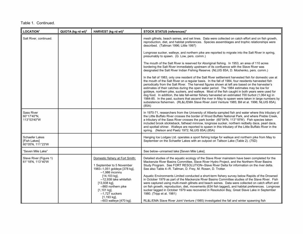
Table 1. Continued.
LOCATION1 QUOTA (kg rd wt)2 HARVEST (kg rd wt)3 STOCK STATUS (references)4
Salt River, continued. mesh gillnets, beach seines, and set lines. Data were collected on catch effort and on fish growth,reproduction, diet, and habitat preferences. Species assemblages and trophic relationships weredescribed. (Tallman 1996; Little 1997)
Longnose sucker, walleye, and northern pike are reported to migrate into the Salt River in spring,presumably to spawn. (G. Low, pers. comm.)
The mouth of the Salt River is reserved for Aboriginal fishing. In 1953, an area of 110 acresbordering the Salt River immediately upstream of its confluence with the Slave River wasdesignated the Salt River Indian Fishing Reserve. (NLUIS 85A; D. Moshenko, pers. comm.)
In the fall of 1983, only one resident of the Salt River settlement harvested fish for domestic use atthe mouth of the Salt River on a regular basis. In the fall of 1984, four residents harvested fishperiodically from the Salt River. The harvest figures shown at left are based on the harvester’sestimates of their catches during the open water period. The 1984 estimates may be low forgoldeye, northern pike, suckers, and walleye. Most of the fish caught in both years were used fordog food. In addition, the late fall-winter fishery harvested an estimated 700 burbot (1,064 kg) in1984-85. In the past, suckers that ascend the river in May to spawn were taken in large numbers bysubsistence fishermen. (RL&L/EMA Slave River Joint Venture 1985; Bill et al. 1996; NLUIS 85A).(85A)
Sass River60°17'40"N,113°53'40"W
In 1970-71, researchers from the University of Alberta sampled fish and water where this tributary ofthe Little Buffalo River crosses the border of Wood Buffalo National Park, and where Preble Creek,a tributary of the Sass River crosses the park border (60°04'N, 113°18'W). Fish species takenincluded brook stickleback, fathead minnow, longnose sucker, northern redbelly dace, pearl dace,and spottail shiner. Walleye are reported to spawn in this tributary of the Little Buffalo River in thespring. (Nelson and Paetz 1972; NLUIS 85A) (85A)
Schaefer Lakes[Fish Lakes]60°05'N, 111°23'W
Hanging Ice Lodges Ltd. operates a sport fishing lodge for walleye and northern pike from May toSeptember on the Schaefer Lakes with an outpost on Taltson Lake (Table 2). (75D)
“Seven Mile Lake” See below--unnamed lake [Seven Mile Lake].
Slave River (Figure 1)61°18'N, 113°40'W
Domestic fishery at Fort Smith:
1 September to 5 November1983--1,051 goldeye [378 kg], --1,986 inconnu [14,103 kg], --12,938 lake whitefish [13,938 kg], --860 northern pike [1,101 kg], --1,727 suckers [1,193 kg], --603 walleye [470 kg];
Detailed studies of the aquatic ecology of the Slave River mainstem have been completed for theMackenzie River Basins Committee, Slave River Hydro Project, and the Northern River BasinsStudy Program. See FORT RESOLUTION--Slave River Delta for information on the river delta. See also Table 4--R. Tallman, D. Frey, M. Rosen, D. Trotter.
Aquatic Environments Limited conducted a short-term fishery survey below Rapids of the Drownedin October 1979 as part of the Mackenzie River Basins Committee studies of the Slave River. Fishwere captured using multi-mesh gillnets and beach seines. Data were collected on catch effort andon fish growth, reproduction, diet, movements (634 fish tagged), and habitat preferences. Longnosesucker tagged in October 1979 was recovered in Resolution Bay, Great Slave Lake in September1980. (Tripp et al. 1981)
RL&L/EMA Slave River Joint Venture (1985) investigated the fall and winter spawning fish

Table 1. Continued.
LOCATION1 QUOTA (kg rd wt)2 HARVEST (kg rd wt)3 STOCK STATUS (references)4
Slave River, continued. 1 September to 29 October1984--2,233 goldeye [1,050 kg], --3,628 inconnu [8,686 kg], --14,032 lake whitefish [13,050 kg], --1,066 northern pike [1,972 kg], --1,578 suckers [2,051 kg], --1,086 walleye [1,271 kg];
Aboriginal food fishery at FortSmith:
21 May-27 October 1995--857 goldeye [257 kg], --1,069 inconnu [4,276 kg], --4,210 lake whitefish [4,210 kg], --620 longnose +white sucker [930 kg], --437 northern pike [874 kg], --916 walleye [916 kg].
10 May-23 October 1996--817 goldeye [245 kg], --653 inconnu [2,612 kg], --4,448 lake whitefish [4,448 kg], --1,268 longnose +white sucker [1,268 kg], --320 northern pike [640 kg], --981 walleye [981 kg].
species in the Slave River from Fort Smith to Great Slave Lake between late summer 1983 andwinter 1985. This program was part of the environmental studies relating to potential hydroelectricdevelopment of the Slave River. Fish movements were studied, spawning habitats mapped, andresource use was quantified. Most fish were captured using gillnets or by electrofishing but traps,boat set seines, and set lines were also used. Echo sounding was used to locate concentrations offish. Data were collected on fish growth, reproduction, and diet; a subsample of healthy fish weretagged with Floy tags or radio transmitters for movement studies; fish eggs were collected using anairlift pump, a roving suction sampler, drift nets, and dredges.
The Slave River was sampled in 1994 and 1995 as part of the Northern River Basins Study . Fishwere collected during the open water period using multi-mesh experimental gillnets, single meshgillnets, beach seines, and set lines. Data were collected on catch effort and on fish growth,reproduction, diet, and habitat preferences. Radio tags were attached to a subsample of inconnuand burbot to follow their movements. Species assemblages and trophic relationships weredescribed for the Slave River, Slave River Delta, and Salt River. (Tallman 1996; Little 1997;Howland 1997)
Fish species reported from the Slave River and its tributary the Salt River are listed in Appendix 1. Northern pike, walleye and goldeye live in the river year round and are generally found at highernumbers than other species throughout the open water period. Flathead chub, longnose sucker,and burbot are also resident species but being aggregate spawners are found in highest abundanceduring the spring and early summer or, in the case of burbot, under the ice in December. Taggingstudies have documented movements by individuals of each of these species, flathead chubexcepted, between the upper Slave River near Fort Smith and Great Slave Lake. Sexually matureinconnu and lake whitefish are present in the system mainly during their spawning migrations fromGreat Slave Lake in the late summer and fall. Lamprey ammocoetes (young) are found in the SlaveRiver from Fort Smith to Great Slave Lake. (Keleher 1963; Buchwald 1968; Nursall and Buchwald1972; Tripp et al. 1981; RL&L/EMA Slave River Joint Venture 1985; Boag and Westworth 1993;Tallman 1996; Tallman et al. 1996c; Howland 1997)
Inconnu begin migrating into the Slave River from Great Slave Lake in mid-August, with peakmovements in late August or early September. The initial upstream movement is rapid, followed bya holding pattern near the final point of migration or fall back to downstream locations. Catches ofpre-spawning inconnu peak in the upper Slave River (Buffalo Crossing to Fort Smith) in earlySeptember and again in mid-October. The species does not occur upstream of Rapids of theDrowned at Fort Smith. Inconnu spawning is suspected at the base of these rapids, in theCunningham Landing area, and in the mid-river area (Point Ennuyeuse to below Grand Detour). Inconnu spawning may be limited in the area of Rapids of the Drowned by the intensity of thedomestic fishery. Preferred spawning habitat ranges from cobble to clay to hard-packed sand. Spawning probably occurs in mid-October and thereafter there is a rapid post-spawning movementof inconnu downstream and into Great Slave Lake. It is not known whether juvenile inconnuoverwinter in the Slave River. Inconnu in the Slave River remain in fresh water throughout theirlives. In 1984, the population of the run was estimated at 19,530 fish (95% CI 15,856 -24,638).(Melvill 1914; Dymond 1943; Fuller 1955; Tripp et al. 1981;

Table 1. Continued.
LOCATION1 QUOTA (kg rd wt)2 HARVEST (kg rd wt)3 STOCK STATUS (references)4
Slave River, continued. 16 May-17 October 1997--859 goldeye [258 kg], --1,035 inconnu [4,140 kg], --4,062 lake whitefish [4,062 kg], --1,068 longnose +white sucker [1,068 kg], --167 northern pike [334 kg], --625 walleye [625 kg].
16 May-17 October 1998--686 goldeye [205 kg], --1,797 inconnu [7,188 kg], --1,270 lake whitefish [1,270 kg], --379 longnose +white sucker (379 kg), --216 northern pike (432 kg), --549 walleye (549 kg). Domestic fishery at CunninghamLanding:
14 September to 27 October1984--94 goldeye [44 kg], --179 inconnu [921 kg], --1,067 lake whitefish [992 kg], --101 northern pike [187 kg], --217 suckers [282 kg], --515 walleye [603 kg].
RL&L/EMA Slave River Joint Venture 1985; Boag and Westworth 1993; Tallman 1996; Tallman etal. 1996a,b; Howland 1997)
In 1995-98, DFO Floy tagged 1034 inconnu in the area of the Slave River between Salt River andRapids of the Drowned. By March 1999, the Great Slave Lake commercial fishery had recaptured99 of these fish which, were dispersed throughout the lake, and the Aboriginal food fisheries hadrecaptured 10 tagged inconnu in Resolution Bay of Great Slave Lake and 17 in the Slave River nearFort Smith (G. Low, unpubl. data)
Lake whitefish abundance in the delta area increases in early September with upstream movementscontinuing into late October. Migrants from Great Slave Lake have been taken as far upstream asRapids of the Drowned at Fort Smith, but tag recoveries suggest that there may also be asubstantial resident population of lake whitefish in the river. Spawning occurs in October, mainly inthe upper areas of the river. Rapids of the Drowned may be an important spawning area; eggs havebeen recovered from several sites between the rapids and Salt River (see above). Spawning wasalso documented as far downstream as mile 379 below Grand Detour. (Tripp et al. 1981; RL&L/EMASlave River Joint Venture 1985; Tallman 1996)
Cisco spawn in large numbers in the Slave River Delta, but there is also a migration of large-bodiedcisco from Great Slave Lake to Rapids of the Drowned in October. Some spawning appears tooccur in all reaches of the river. Spawning runs of small-bodied cisco begin in late September andpeak in late October, with some fish migrating upstream as far as Fort Smith. Spawning areas for these ciscos appear to be situated from below Long Island downstream tothe Slave River Delta. (RL&L/EMA Slave River Joint Venture 1985)
Burbot run into the Slave River Delta after 1 November and prior to freeze-up. A movement ofburbot into the Slave River may occur under the ice, as concentrations are present in the Fort Smitharea in early to mid-December. These are thought to be pre-spawning movements. Spawning mayoccur in or near the Slave River Delta and in the Cunningham Landing/Salt River areas in lateDecember to February. A burbot tagged in Great Slave Lake north of Hay River on 19 September1953 was recaptured in the Slave River at Fort Smith 90 days and 400 km later, and another taggedat Rapids of the Drowned near Fort Smith was recovered by commercial fishermen in the north armof Great Slave Lake. (Keleher 1963; RL&L/EMA Slave River Joint Venture 1985; Tallman 1996;Tallman et al. 1996a+b)
The Slave River continues to be a major fishing site for traditional harvesters who fish to feedthemselves and their dogs. Aboriginal residents of Fort Smith have traditionally harvested whitefish,northern pike, suckers, and goldeye in the spring after the ice goes out; inconnu and a few lakewhitefish and northern pike from mid-August until freeze-up; and burbot in November. Gillnets areset in eddies offshore Fort Smith, amongst the islands and across the river from the town, and as fardownstream as the mouth of the Salt River. (Bill et al. 1996; G. Low, pers. comm.).
Elders reported in Bill et al. (1996) that whitefish used to be caught all summer long, but this isapparently no longer the case. Domestic fishermen were interviewed over the September to freeze-up periods in both 1983 and 1984. There was a substantial fall domestic fishery in the vicinity ofFort Smith at the base of Rapids of the Drowned. Most gillnets were set along the

Table 1. Continued.
LOCATION1 QUOTA (kg rd wt)2 HARVEST (kg rd wt)3 STOCK STATUS (references)4
Slave River, continued. south bank of the river near town. Lake whitefish were the most abundant species in the catch butinconnu contributed more by weight. Smaller fisheries were monitored at Cunningham Landing,Salt River, and the Slave River Delta. The principal domestic fishery for burbot was located in theCunningham Landing area, where an estimated 2,200 fish (3,344 kg) were harvested in the winter of1984-85. Walleye was the species preferred for human consumption, while inconnu and burbotwere the preferred dog foods. Most of the fish harvested were used for dog food: inconnu 90%, lakewhitefish 65%, northern pike 80%, walleye 30%, suckers 95%, goldeye 85%, and burbot 95%. Therate of exploitation of spawning inconnu is high, estimated at 0.20 in 1984. (RL&L/EMA Slave RiverJoint Venture 1985)
DFO collected data on the Aboriginal food fishery at the Slave River by residents of Fort Smith fromMay to October 1995-98. The harvest estimates, shown to the left, are based on these data andrepresent the annual total harvest (±20% in 1995; 90% of the annual total harvest in 1996-98). (DFO 1997; G. Low, pers. comm.)
The Slave River was closed to fishing by holders of non-Aboriginal domestic fishing licences from 15August and 30 October during the 1995-98 fishing seasons. The intent of this measure was toreduce fishing pressure on the inconnu. This restriction has been removed for the 1999 fishingseason, as the inconnu stock is capable of supporting the non-Aboriginal domestic fishery. In 1999,only two non-Aboriginal domestic fishing licences, each for a maximum of 500 kg of fish, wereissued for the Slave River. (G. Low, pers. comm.)
DFO measured organic contaminants in the livers of burbot from the Slave River in the mid 1980's(Whittle 1989; Muir et al. 1990). In 1995-96, Evans et al. (1997) studied the contribution of organiccontaminants by the Slave River to Great Slave Lake.
Monenco Consultants Limited analysed muscle tissues of goldeye and northern pike captured atFort Smith in 1990 for chlorinated and non chlorinated organic contaminants. Low concentrations ofchlorinated dioxins and furans were found, none of which presents a health risk to peopleconsuming the fish. (Monenco Consultants Limited 1991) (85H)
Soulier Lake60°41'N, 110°08'W
lake trout + lakewhitefish 1,900
This lake on the Tanzin River, a tributary of the Taltson, has a commercial harvest quota but norecord of commercial harvest. (75D)
Star Lake60°18'N, 110°48'W
lake trout, lakewhitefish + walleye[200]
1988-89--NF;1990--lake trout 157 kg, lake whitefish 138 kg, northern pike 13 kg.
In 1990, a DFO experimental fishery sampled lake trout and lake whitefish from Star Lake. (DFO1991, 1992a+b; McGowan et al. 1993) (75D)
“Stovepipe Lake” See below--unnamed lake [Stovepipe Lake]
Taltson Lake See FORT RESOLUTION--Taltson Lake
Taltson River See FORT RESOLUTION--Taltson River
Telklini Lake60°02'N, 111°15'W
lake trout + lakewhitefish 400
This lake near Fort Smith has a commercial harvest quota but no record of commercial harvest.(75D)

Table 1. Continued.
LOCATION1 QUOTA (kg rd wt)2 HARVEST (kg rd wt)3 STOCK STATUS (references)4
Thekulthili Lake61°00'N, 110°06'W
lake trout + lakewhitefish 13,800
1961--lake trout 31,820 kg, lake whitefish 21,390 kg, walleye 107 kg;1965--lake trout and lake whitefish 20,374 kg;1966--lake trout and lake whitefish 7,878 kg;1971-72--lake trout 27,678 kg, lake whitefish 47,522 kg, walleye 1,657 kg;1979--lake trout and lake whitefish 12,051 kg;1980--lake trout 1,275 kg; lake whitefish 2,708 kg.
Commercial harvests of lake trout and lake whitefish were taken from this lake on the ThekulthiliRiver, a tributary of the Taltson, in the winters of 1961-62, 1965, 1966, 1971-72, 1979 and 1980. DFO sampled lake whitefish from Thekulthili Lake in 1965, and measured mercury levels in the fleshof northern pike from the lake in 1971. (Sinclair et al. 1967; Envirocon Limited et al. 1975;Moshenko 1980; Yaremchuk et al. 1989; NLUIS 75D; M. Hendzel, pers. comm.)
In 1986, DFO estimated the guest-bed capacity of Thekulthili Lake for a medium quality lake troutsport fishery at 11 to 15 beds. Big Pine Narrows Camp and Northstar Resort have operated sportfishing lodges at Thekulthili Lake since at least 1988 (Table 2). (M. Roberge, pers. comm.)
In 1981, DFO measured total mercury in the flesh of lake trout (mean 0.31 µg C g-1 wet wt, n=15,range 0.16 - 0.68) from Thekulthili Lake (M. Hendzel, unpubl. data). (75E)
Tourangeau lake60°19'N, 110°32'W
lake trout + lakewhitefish 1,400
This lake on the Tanzin River, a tributary of the Taltson, has a commercial harvest quota but norecord of commercial harvest. (Yaremchuk et al. 1989) (75D)
Trudel Lake60°21'N, 111°19'W
lake trout + lakewhitefish 200
This lake has a commercial harvest quota but no record of commercial harvest. (75D)
Tsu Lake60°40'N, 111°52'W
1959--lake trout 596 kg, lake whitefish 172 kg, northern pike 141 kg, walleye 151 kg.
Tsu Lake is downstream from the reservoir created for the Twin Gorges hydro-electric station byimpounding the flow of the Taltson River at the outlet of Nonacho Lake (see LUTSEL K’E--NonachoLake). Flow in the river has been altered by the impoundment such that the lake level typically risesabout 0.1 m above its natural level in the spring and falls 0.2 m below its natural level in the summerand fall. (Envirocon Pacific Limited 1986)
Envirocon Ltd. sampled burbot, lake cisco, lake trout, lake whitefish, and northern pike from TsuLake in June-September 1973. Fish were captured using mixed-mesh gillnets and beach seines. Data were collected on catch effort; on fish habitat, growth, reproduction, and diet; and on waterchemistry, zoobenthos, and zooplankton. (Envirocon Limited et al. 1975; Envirocon Ltd. unpubl.data--See DFO Permit files).
Residents of Fort Smith fish for subsistence at Tsu Lake. A commercial harvest of lake trout, lakewhitefish, northern pike, and walleye was taken from Tsu Lake in the winter of 1959-60. (Sinclair etal. 1967; Moshenko 1980; Yaremchuk et al. 1989; Bill et al. 1996) (75D)
Students of the Renewable Resources Technology course at Thebacha College in Fort Smithsometimes sample fish at Tsu Lake as part of their course work. See Table 4--K. Antoniak, B.Bergmann, L. Gray, D. Langille, M. Rosen.
unnamed lake60°10'N, 109°21'W
lake trout [500], lakewhitefish [500]
1992--NF. In 1992, an experimental fishery was planned to sample this lake near Fort Smith. The lake was notfished. (DFO 1994) (75C)
unnamed lake[Burnt Lake]60°29'N, 110°45'W
lake whitefish [200] In 1984, an experimental fishery was planned to sample lake whitefish from this lake near FortSmith. There is no record of fishing. (Yaremchuk et al. 1989) (75D)

d to sample lake trout and lake whitefish from this lake5D)
sampled lake whitefish and walleye from this unnamedD)
d lake trout, lake whitefish, and northern pike from this92a+b; McGowan et al. 1993) (75D)
ned to sample this lake on the Taltson River system. a) (75D)
d to sample this lake near Fort Smith. The lake was not
h rainbow trout fry in 1959. (Nelson and Paetz 1972)
lake trout and lake whitefish at this lake on the Taltsonuk et al. 1989) (75D)
rom this lake on the Thekulthili River, a tributary of thenophorus crassus are found in the flesh of whitefish
trout and lake whitefish were taken from, Yatsore Lakeercury levels in lake trout from the lake in 1973. Iny of Yatsore Lake for a high quality lake trout sportremchuk et al. 1989; DFO unpubl. data; M. Hendzel,D)
hery in the vicinity of Hay River in the fall of 1958. ted 12,273 kg of fish for subsistence from October 1959Keleher and Haight 1959; Sinclair et al. 1967)
about 32 km east of Hay River. There is occasionalmouth in the spring. DFO sampled lake whitefish,th in June 1974. (Falk and Dahlke 1975; NLUIS 85B; G.
Table 1. Continued.
LOCATION1 QUOTA (kg rd wt)2 HARVEST (kg rd wt)3 STOCK STATUS (references)4
unnamed lake[Elbow Lake]60°36'N, 111°31'W
lake trout + lakewhitefish [907]
In 1980, an experimental fishery was plannenear Fort Smith. (Yaremchuk et al. 1989) (7
unnamed lake[Germain Lake]60°12'N, 111°03'W
lake trout, lakewhitefish + walleye[200]
1989--lake whitefish 270 kg, walleye 143 kg.
In March 1990, a DFO experimental fishery lake (DFO 1992a; McGowan et al. 1993) (75
unnamed lake[Jean’s Lake]60°22'N, 110°54'W
lake trout, lakewhitefish + northernpike [200]
1989--NF;1990--lake trout 80 kg, lake whitefish 118 kg, northern pike 2 kg.
In 1990, a DFO experimental fishery samplelake on the Taltson River system. (DFO 19
unnamed lake[Mary Lake]60°20'N, 110°46'W
lake trout, lakewhitefish + walleye[200]
1988-89--NF. In 1988-89, experimental fisheries were planThe lake was not fished. (DFO 1991, 1992
unnamed lake[Mary’s Lake]60°14'N, 111°04'W
lake whitefish [200] 1990--NF. In 1990, experimental fisheries were plannefished. (DFO 1992b) (75D)
unnamed lake[Seven Mile Lake]60°00'N, 112°38'W
This lake beside Highway 5 was stocked wit(85A)
unnamed lake[Stovepipe Lake]60°46'N, 111°53'W
An experimental fishery planned in 1980 forRiver system was not conducted. (Yaremch
Yatsore Lake60°46'N, 110°16'W
lake trout + lakewhitefish 2,400
1967--lake trout 2,199 kg, lake whitefish 13,566 kg;1972--lake trout 2,036 kg, lake whitefish 5,280 kg;1973--lake trout 4,020 kg, lake whitefish 9,517 kg.
DFO sampled lake trout and lake whitefish fTaltson, in 1959. Cysts of the parasite Triaefrom the lake. Commercial harvests of lakein 1967, 1972, and 1973. DFO measured m1988, DFO estimated the guest-bed capacitfishery at 4 to 5 beds. (Moshenko 1980; Yapers. comm.; M. Roberge, pers. comm.) (75
HAY RIVER, NORTHWEST TERRITORIES DFO studied and described the domestic fisResidents of Hay River harvested an estimato March 1960; and 46,680 kg in 1961-62. (
Birch Creek60°50'05"N,115°21'45"W
This small creek flows into Great Slave Lakesubsistence and sport fishing near the river northern pike, and walleye at the creek mouLow, pers. comm.) (85B)

Table 1. Continued.
LOCATION1 QUOTA (kg rd wt)2 HARVEST (kg rd wt)3 STOCK STATUS (references)4
Buffalo Lake60°13'N, 115°30'W
In late September and early October of 1958, four trappers from Hay River harvested about 1,640inconnu from Buffalo Lake. Most of the fish were dried and stored on stages for use as dog foodduring the winter trapping season. The subsistence harvest at Buffalo Lake has declined with thedecline in use of working dogs in the trapping industry, and the move of permanent and seasonalresidents to Hay River. Now, inconnu and lake whitefish are only harvested occasionally forsubsistence near the lake outlet and near the mouth of the Yates River, with by-catches of northernpike, sucker and walleye. The inconnu, which migrate from Great Slave Lake into the tributaries ofBuffalo Lake, are overexploited but the other species are not. The whitefish are typically small riverfish which are apparently non-migrant residents of the individual tributaries. They are generallyheavily infested with Triaenophorous sp. DFO estimated the basic needs level at 1,000 kg. (Keleher and Haight 1959; Sinclair et al. 1967; NLUIS 85B; DFO unpubl. data; G. Low, pers. comm.)
In 1983, DFO captured 100 walleye from Buffalo Lake and released them into Sandy Lake (seebelow). (G. Low, pers. comm.) (85B)
Buffalo River60°52'50"N,115°02'30"W
The Buffalo River drains Buffalo Lake (see above) into Great Slave Lake about 60 km east of HayRiver. DFO sampled fish at the river in 1945-48, 1955, 1956, and from 1976-95. Inconnucongregate at the river mouth in the spring, and tag recovery data indicates that at least some ofthese fish enter the Buffalo River in early summer and migrate slowly upstream to Buffalo Lake,where they congregate in fall at the mouths of tributary rivers (see below unnamed river [UpperBuffalo River], Whitesand River and Yates River). They then leave these river mouths, presumablyto spawn upstream and appear in spent condition at the river mouths in early winter. Attempts tolocate spawning areas in the lower 45 km of the tributaries of Buffalo Lake have been unsuccessful. Spawning may occur further upstream in the headwaters which are located in northern Alberta at thebase of the Caribou Mountains. The number of resting fish in the Great Slave Lake samplessuggest that these inconnu do not spawn every year. There is also a downstream, post-spawningmigration of inconnu in the Buffalo River in late September and early October. The timing of freeze-up of the Buffalo River may determine the extent of overwintering in the tributaries of Buffalo Lake. It is not known whether these are discrete stocks of inconnu. (Fuller 1955; Day and Low 1993)
The mean length and age of inconnu declined from 745 mm and 9 years in 1947 to 680 mm and 7years by the mid-late 1970's and had not recovered by 1992. Over 1000 inconnu were tagged at themouth of the Buffalo River between 1976 and 1978; only 9 tag recaptures were reported in the 1980season. This suggests a high mortality rate in the interim for these inconnu. They ranged 140 kmupstream to the Yates and Whitesand rivers, and along the southern shore of Great SLave Lakefrom Spruce Point (166 km east) to Deep Bay (81 km west). They showed moderate year-to-yearsite fidelity, with 73 fish recaptured at the river mouth in subsequent years. Of 33 inconnu examinedin 1946, 94% had cysts of the parasite Triaenophorus crassus in their flesh. The rate of infestationwas 70 cysts per 45.5 kg of flesh. The mouth of the Buffalo River is a nursery area for walleye. Fish species reported from the Buffalo River are listed in Appendix 1. (Melvill 1914; Fuller 1955;Day and Low 1993; NLUIS 85B)

Table 1. Continued.
LOCATION1 QUOTA (kg rd wt)2 HARVEST (kg rd wt)3 STOCK STATUS (references)4
Buffalo River,continued.
The area of Great Slave Lake within a radius of 2 km from the river mouth has been closed tocommercial fishing since 1983 (Fig. 3). Subsistence fishermen have harvested fish for dog foodfrom Buffalo Lake near its exit into the Buffalo River, and from its’ tributaries. This fishery hasdeclined with the decline in the use of working dogs in the trapping industry (Day and Low 1993;DFO unpubl. data)
The Buffalo River is accessible by road where it is crossed by Highway 6. The crossing area,however, is not well suited to angling as the river becomes very silty once the ice melts on BuffaloLake. The river mouth, which is accessible by boat during the open water season, is seldom fishedfor sport due to its heavy silt load. DFO sampled inconnu, lake whitefish, and walleye at the rivermouth in June 1974. Seine hauls at the river mouth also produced good catches of walleye. (Falkand Dahlke 1975; G. Low, pers. comm.)
DFO considers the stock(s) of inconnu in the Buffalo River to have been severely overexploited, andhas recommended measures to reduce the harvest by the Great Slave Lake commercial fishery. Despite these measures recovery of the Buffalo River stock is expected to be slow. Researchprograms have also been recommended to delineate the stocks and examine the movements andlife history of the Buffalo River inconnu. See also Table 4--G. Low. (Day and Low 1993) (85B)
Hay River60°51'50"N, 115°44'W
Sport harvest:1975--2,120 walleye (860 kg), 1.23 walleye/angler/hr.1978--2,484 walleye,1986--3,155 walleye
Aboriginal food fishery harvestduring the whitefish run inSeptember and October 1996:
--19 burbot (38 kg),--3 inconnu (12 kg),--1 lake trout (3 kg),--3,420 lake whitefish (3,420 kg),--84 longnose sucker (168 kg),--30 northern pike (60 kg),--19 walleye (19 kg).
The Hay River is a spring migration route for longnose sucker, walleye and occasionally inconnu,and a fall migration route for lake whitefish. The Louise and Alexandra falls form an impassablebarrier upstream. The northern pike are likely resident in the river. Longnose suckers run into theHay River following ice break-up in the spring to spawn, in May to mid-June, and then return toGreat Slave Lake. Lamprey ammocoetes (young) are found in the lower 32 km of the Hay River. Anumber of ammocoete beds (spawning locations) have been documented in the river. Spawningoccurs prior to July 8. Fish species reported from the Hay River are listed in Appendix 1. (Fuller1955; Harris 1962; Buchwald 1968; Nursall and Buchwald 1972; Bond et al. 1978; Moshenko andLow 1980; Clarke et al. 1989; NLUIS 85B; G. Low, pers. comm.)
Lake whitefish are harvested for subsistence in the east and west channel and occasionallyupstream from Vale Island. Domestic gillnets are not to span more than two thirds of the river. In1997, the basic needs level was estimated at 15,000 kg of lake whitefish. DFO collected data onthe Aboriginal food fishery at the Hay River during September and October 1996. The total annualharvest is unknown. (NLUIS 85B+C; DFO unpubl. data; G. Low, pers. comm.)
Residents of Hay River harvest mainly walleye but also burbot, inconnu, and northern pike for sportfrom the Hay River in June through October, mostly near the community in the vicinity of ValeIsland, but some upstream at the crossing of Highway 6 and at the base of Louise Falls. DFOsurveyed the walleye sport fishery in 1975, 1978, and 1986. Partial creel censuses were conductedin 1972 and 1974, a questionnaire survey in 1979, and there are also DFO data from 1983. Overthis period, the fishing effort increased substantially while the catch per unit effort decreased by30%, from 1.2 to 0.8 walleye per angler hour. However, the mean length of fish sampled increasedfrom 338 to 365 mm, and the mean age from 5 to 7 years--suggesting that recruitment is adequateto met the need of stock replacement. The stock

Table 1. Continued.
LOCATION1 QUOTA (kg rd wt)2 HARVEST (kg rd wt)3 STOCK STATUS (references)4
Hay River, continued. definition is unknown, except that the fish are not part of a spawning run as most are eitherimmature or unripe adults. The stock is not harvested by the Great Slave Lake commercial fishery,since the Hay River domestic zone protects stocks in an area 5 statute miles offshore between Pointde Roche in the west and Fish Point to the east (Fig. 3). In 1989, DFO recommended that currentregulations be maintained, a creel census with biological sampling be repeated every 3 years, and atagging program be implemented to determine movement patterns of the walleye. See also Table4--G. Low, M. Digel, H. Westers. (Gillman and Dahlke 1973; Falk and Dahlke 1975; Bond et al.1978; Moshenko and Low 1980; Falk 1981; Clarke et al. 1989; DFO unpubl. data)
In 1984, 1989, and 1990 DFO Fish Inspection sampled northern pike, walleye and whitefish from theHay River commercial fishery for their concentrations of heavy metals and organic contaminants. (Wong 1986; M. Hendzel pers. comm.) (85B)
MacDonald Lake See LUTSEL K’E--MacDonald Lake.
Sandy Lake60°31'30"N, 114°35'W
In January 1979, DFO conducted a limnological survey to assess the potential of lakes in the HayRiver area for commercial aquaculture. Sandy Lake and two unnamed lakes (Polar and #9) (seebelow) were the only lakes in the area suitable for stocking but together were not sufficientlyproductive to support an aquaculture industry. In August 1983, 100 live walleye were transferredfrom Buffalo Lake (see above) in Wood Buffalo National Park to Sandy Lake which is located offHighway 5 on the Park border. Twenty-five of the fish died immediately following transfer. A fewwalleye have been caught since then but the stock has not reproduced. Limnological surveys ofthe lake were conducted in 1979-82, prior to stocking. Depth, temperature and dissolved oxygenprofiles were determined and the plankton, benthos, and fish were sampled. The lake supportsbrook stickleback and northern pike. (M. Papst, unpubl. data; G. Low, pers. comm.) (85B)
Sandy River[Sandy Creek]60°50'N, 115°37'20"W
This stream, also called Sandy Creek, flows into Great Slave Lake about 10 km east of Hay River. In June 1958, DFO sampled northern pike from the lower reaches of Sandy River. Fish were caughtby angling at a rate of 3.6 fish per rod-hour (5 kg). The catch per hectare of river surface was 6.44kg (35 lbs per acre). DFO also sampled lake whitefish, northern pike, sucker, and walleye at theriver mouth in June 1974. Where it is crossed by Highway 6, the river is small and shallow. Anglingis confined to the mouth and lower reaches which are very scenic. Cottagers and itinerant anglerswho visit the area by boat from Hay River catch northern pike and walleye at the river mouth fromJune through August. (Keleher and Haight 1959; Falk and Dahlke 1975; NLUIS 85B; G. Low, pers.comm.) (85B)
unnamed lake[Polar Lake]60°51'N, 115°10'W
Polar Lake, which is situated just north of Highway 5, between Hay River and Pine Point, isaccessible year-round by road. Camping, picnicking and boat launch facilities make it an attractiverecreational area for anglers and non-anglers. DFO surveyed the lake in 1969 and 1971 to assessits stocking potential. The only fish caught were brook stickleback, and the lake was found to besuitable for stocking. In 1971, it was stocked with 40,000 brook trout by the Pine Point Wildlife andWilderness Club. The stocking was considered successful and anglers enjoyed good success forseveral years. It was restocked with 12,000 rainbow trout in 1977 and 10,000 in 1978. DFOconducted spring and fall fish sampling from 1977 to 1979.

Table 1. Continued.
LOCATION1 QUOTA (kg rd wt)2 HARVEST (kg rd wt)3 STOCK STATUS (references)4
unnamed lake[Polar Lake], continued.
Brook trout were not caught, perhaps due to a winterkill. The re-stocking was also successful as therainbow trout grew to catchable size after one year and a recreational fishery was created in an areawhere such opportunities are limited. The rainbow trout which weighed about 76 g when they werestocked in 1977, grew to 494 g after one year and 761 g after two years. Rainbow trout thatweighed about 29 g when they were stocked in 1978 grew to 282 g in 1979. A taste testing panelfound the fish to be of good quality. Continued monitoring was recommended in order to improveunderstanding of the growth and survival of fish introduced to waters of the Northwest Territories. In January 1979, DFO conducted a limnological survey to assess the potential of lakes in the HayRiver area for commercial aquaculture. Polar Lake, Sandy Lake (see above), and unnamed lake(#9) (see below) were the only lakes in the area suitable for stocking but together they were notsufficiently productive to support an aquaculture industry. DFO also conducted a questionnairesurvey in 1979, to gather information on sport fishing at Polar Lake. Anglers were harvestingrainbow trout from the lake in July. The lake was re-stocked with rainbow trout fingerlings in May1980 (12,500), May 1981 (10,000), July 1983 (10-12,000), 1985 (12,000--50% transport mortality)and 1986 (12,000), and Arctic charr in May 1991 (3,000 surplus broodstock, 2.5 year old fish). DFOsampled rainbow trout from creels at the lake in June 1981, conducted an experimental gillnetfishery in November 1981, and took periodic water temperature and dissolved oxygenmeasurements from then until May 1982. A subsequent DFO experimental fishery October 1987captured rainbow trout with a maximum age of 6 years. The lake appears to be too warm for Arcticcharr since temperature-related summer kills have been observed. (Falk 1981; Falk and Low 1981;Papst, unpubl. data)
While the outlet to Polar Lake is impassable to fish, rainbow trout--presumably from the lake, havebeen caught at the mouth of the Buffalo River. These fish are believed to have been introducedfrom Polar Lake into the Buffalo River by anglers hoping to establish the species. During periods ofhigh water, rainbow trout have been observed to move into swampy areas to feed. Fish that aretrapped there winterkill. (G. Low, pers. comm.) (85B)
unnamed lake[lake #9]60°44'N , 114°57W
In January 1979, DFO conducted a limnological survey to assess the potential of lakes in the HayRiver area for commercial aquaculture. Sandy Lake (see above), an unnamed lake (see aboveunnamed lake [Polar Lake]), and this small lake near Highway 5 were the only lakes in the areasuitable for stocking but together they were not sufficiently productive to support an aquacultureindustry. (M. Papst, unpubl. data)
DFO surveyed the lake again in June 1984 and April 1985. It may winterkill as dissolved oxygenlevels below 1 ppm were found just prior to break-up. The lake was stocked with 400 rainbow troutby the Hay River Fish and Game Association in June 1985. It was re-stocked with 8,707 rainbowtrout in May 1988. Test netting in October yielded 27 fish (mean wt. 328 g) which were feeding onbrook stickleback. A significant number of fish may have been eaten by loons and ternsimmediately following stocking or escaped the lake during high water. Several borrow pits in theHay River area were also stocked with varying success. (G. Low, pers. comm.; DFO unpubl. data)(85B)
unnamed river[Upper Buffalo River]60°05'N, 115°17'W
Inconnu congregate at the mouth of this tributary of Buffalo Lake (see above) in the fall and arebelieved to spawn upstream. Fry and fingerling inconnu have been observed 20 km upstream. (Day and Low 1993; D. Sonfrere, pers. comm.) (85B)

Lake (see above) in the fall to spawn. Anglers from Haymobile in winter to fish for walleye and northern pike.
5B)
utary of Buffalo Lake (see above) in the fall. DFO early December of 1976, 1977, and 1978 yielded 181 and 1992 yielded only a few inconnu--suggesting thatnnu tagged at the river mouth in 1976-78, ranged at
ee of site fidelity. They were recaptured the followingve), at the mouth of the Buffalo River (see above), and inlers from Hay River travel to the Yates River by northern pike. They reported poor fishing for walleye inD. McGowan, pers. comm.) (85B)
vember 1961, Aboriginal food fishery by residents of)
of Artillery Lake, on the Lockhart River, remain virtually and Clarke provided brief descriptions of their successry. Lake trout from the lake were sampled by and a DFO experimental fishery in July 1990. Cysts of the in 2 of the 11 fish sampled by the latter study, with an skinnier (i.e. had low condition factors) than those found
shed for subsistence, and is occasionally visited byIn 1988, DFO estimated the guest-bed capacity ofort fishery at 20 to 25 beds. (Tyrell 1902; Critchell-acDonald and Fudge 1978; NLUIS 75KM; M. Roberge,
ke trout, and round whitefish from Clinton-Colden Lake inn 1988, DFO estimated the guest-bed capacity oftrout sport fishery at 20 to 25 beds. (Johnson 1976;) (75O)
acity of this lake on the Snowdrift River for a mediumds. (M. Roberge, pers. comm.) (75J)
ike, suckers and whitefish from this lake on the Snowdriftts of lake trout and lake whitefish were taken from1, with a small by-catch of inconnu in 1971. DFOe trout from Gagnon Lake in 1971. The lake was openedut not fished. (Yaremchuk et al. 1989; DFO unpubl. data;
ike, suckers and whitefish from this lake on the
Table 1. Continued.
LOCATION1 QUOTA (kg rd wt)2 HARVEST (kg rd wt)3 STOCK STATUS (references)4
Whitesand River60°10'30"N, 115°45'W
Inconnu migrate up this tributary of Buffalo River travel to the Whitesand River by snow(G. Low and D. McGowan, pers. comm.) (8
Yates River[Big River]60°09'50"N,115°50'55"W
Inconnu congregate at the mouth of this tribsampling at the mouth of the Yates River ininconnu. A repeat of this sampling in 1991the stock was depleted in the 1980's . Incoleast 180 km and showed a moderate degryears in the river, in the Hay River (see aboGreat Slave Lake near Sulphur Point. Angsnowmobile in winter to fish for walleye andthe winter of 1994/95. (Day and Low 1993;
LUTSEL K’E (formerly Snowdrift), NORTHWEST TERRITORIES DFO studied and described the October-NoSnowdrift. (Keleher and Haight 1962, 1965
Artillery Lake63°09'N, 107°52'W
Despite its large size, the fishery resourcesunknown. Tyrell, Critchell-Bullock, Hornby,gillnetting fish at the lake early in the centuexperimental gillnet fishery in July 1978, anparasite Triaenophorus crassus were foundaverage of 2 cysts per fish . The trout werein Great Slave Lake. The lake has been fianglers from lodges on Great Slave Lake. Artillery Lake for a high quality lake trout spBullock 1931; Hornby 1934; Clarke 1940; Mpers. comm.; G. Low, unpubl. data) (75K)
Clinton-Colden Lake63°55'N, 107°29'W
DFO sampled Arctic grayling, lake cisco, la1959, during the Barren Grounds Survey. IClinton-Colden Lake for a high quality lake Moshenko 1980; M. Roberge, pers. comm.
Eileen Lake62°16'N, 107°37'W
In 1988, DFO estimated the guest-bed capquality lake trout sport fishery at 9 to 14 be
Gagnon Lake61°58'N, 110°23'W
lake trout + lakewhitefish 6300
1962--lake trout 11,168 kg, lake whitefish 8,629 kg;1963--lake trout 5,095 kg, lake whitefish 2,433 kg;1970--lake trout 5,924 kg, lake whitefish 7,409 kg;1971--lake trout 9,956 kg, lake whitefish 13,909 kg.
DFO sampled burbot, lake trout, northern pRiver in August 1962. Commercial harvesGagnon Lake in 1962, 1963, 1970 and 197measured mercury levels in the flesh of lakfor commercial harvest in 1974 and 1983, bM. Hendzel, pers. comm.)
DFO sampled burbot, lake trout, northern p

Table 1. Continued.
LOCATION1 QUOTA (kg rd wt)2 HARVEST (kg rd wt)3 STOCK STATUS (references)4
Gagnon Lake,continued.
inconnu--no quota By-catches:1971--inconnu 2 kg.
Snowdrift River in August 1962. Commercial harvests of lake trout and lake whitefish were takenfrom Gagnon Lake in 1962, 1963, 1970 and 1971, with a small by-catch of inconnu in 1971. Thelake was opened for commercial harvest in 1974 and 1983, but not fished. (Yaremchuk et al. 1989;DFO unpubl. data)
In 1987, DFO estimated the guest-bed capacity of Gagnon Lake for a medium to low quality laketrout sport fishery at 5 to 10 beds, given that the resource would be shared with the existingcommercial fishery. (M. Roberge, pers. comm.) (75L)
Gray Lake61°52'N, 108°15'W
A rockfill dam built in 1968 at the outlet of Nonacho Lake (see below) has impounded the flow of theTaltson River (see FORT RESOLUTION--Taltson River), raising the lake level about a metre andcreating a large reservoir that includes Gray Lake. The shores of the lake have been flooded andthe seasonal flow patterns altered. Envirocon Ltd. sampled lake trout, lake whitefish, and northernpike from Gray Lake in June-September 1973. Fish were captured using mixed-mesh gillnets andbeach seines. Data were collected on catch effort; on fish habitat, growth, reproduction, and diet;and on water chemistry, zoobenthos, and zooplankton. (Envirocon Limited et al. 1975; EnviroconLtd. unpubl. data--See DFO Permit files).
DFO analysed the flesh of lake whitefish, lake trout, and northern pike from Gray Lake for totalmercury in 1986. The lake whitefish (mean 0.18 µg C g-1 wet wt, n=15, range 0.09 - 0.48) werefound to be suitable for commercial sale but the lake trout (mean 0.53, n=12, range 0.19 - 0.87) andnorthern pike (mean 0.77, n=3, range 0.38 - 1.04) were not. (M. Hendzel, unpubl. data) (75F)
Lac Duhamel62°19'N, 110°45'W
Guests of Frontier Lodge on Great Slave Lake occasionally visit this lake to angle for northern pike. (NLUIS 75L) (75K)
La Loche Lakes62°00'N, 110°53'W
lake trout + lakewhitefish 5,200
northern pike--no quota
1968--lake trout 713 kg, lake whitefish 1,243 kg;1969--lake trout 872 kg, lake whitefish 2,218 kg;1970--lake trout 1,309 kg, lake whitefish 3,119 kg
By-catches:1968--northern pike 52 kg;1969--northern pike 237 kg
Commercial harvests of lake trout and lake whitefish were taken from these lakes on the La LocheRiver, a tributary of Great Slave Lake, in 1968, 1969 and 1970, with small by-catches of northernpike in 1968 and 1969. DFO sampled lake trout and lake whitefish from the lake in 1968. Arcticgrayling, suckers, and walleye are also present in the system. (Moshenko 1980; Yaremchuk et al.1989; NLUIS 75E+L) (75E)
Lady Grey Lake See FORT SMITH--Lady Grey Lake
Lockhart River 62°48'05"N, 108°54'W(Figure 1)
In 1977, an experimental gillnet fishery sampled fish at 11 sites on the Lockhart River system, in theNorth Slave study area. Species reported are listed in Appendix 1. In fall, lake trout spawn in thesand and gravel sections near the mouth of the Lockhart River. This area is also fished for sport byanglers from a nearby lodge. Arctic grayling spawn in the section of the river (63°44'N, 111°58'N)immediately upstream from Warburton Lake in the spring. (Stewart and MacDonald 1978; NLUIS75K+M) (75K)

Table 1. Continued.
LOCATION1 QUOTA (kg rd wt)2 HARVEST (kg rd wt)3 STOCK STATUS (references)4
Lynx Lake62°25'N, 106°15'W
In 1978, an experimental gillnet fishery sampled lake trout and lake and round whitefish from thisheadwater lake on the Thelon River system. In 1981, DFO estimated the guest-bed capacity ofLynx Lake for a medium quality lake trout fishery at 16 to 25 beds, provided the resource was notshared with the commercial fishery. Lynx Tundra Camp operated a sport fishing lodge at the lakeuntil 1992 (Table 2). (MacDonald and Fudge 1979; M. Roberge, pers. comm.) (75J)
McDonald Lake62°07'N, 111°30'W
lake trout + lakewhitefish 4,600
northern pike +walleye--no quota
1960--lake trout 2,153 kg, lake whitefish 1,178 kg;1961--lake trout 9,988 kg, lake whitefish 10,782 kg;1966--lake trout 22,776 kg, lake whitefish 3,398 kg;1972--lake trout 7,516 kg, lake whitefish 9,353 kg;1973--lake trout 470 kg, lake whitefish 684 kg;1974--lake trout 255 kg lake whitefish 332 kg;1978--lake trout 683 kg, lake whitefish 1,049 kg;1979--lake trout and lake whitefish 1,809 kg;1980--lake trout 2,668 kg, lake whitefish 2,713 kg.By-catches:1961--walleye 3 kg;1966--northern pike 21 kg;1978--northern pike 78 kg.
This lake which drains directly into Great Slave Lake was fished commercially for the first time in1953 by fishermen based at Hay River. DFO sampled lake whitefish from the commercial catchesin January and February 1953. Commercial harvests of lake trout and lake whitefish were alsotaken from McDonald Lake between 1960 and 1980, with small by-catches of walleye in 1961 andnorthern pike in 1966 and 1978. DFO measured mercury levels in the flesh of lake trout fromMcDonald Lake in 1980. (Kennedy 1963; Sinclair et al. 1967; Healey 1975; Yaremchuk et al. 1989;NLUIS 75L; M. Hendzel, pers. comm.) (75L)
Mary Lake62°23'N, 103°31'W
lake trout + lakewhitefish 9,200
In 1978, an experimental gillnet fishery sampled lake trout and lake whitefish from this lake on theHanbury River, a tributary of the Thelon. Trappers from Lutsel K’e have trapped Arctic fox in thisarea. When they do, fish are harvested for subsistence. The extent of these fall harvests isunknown. Mary Lake has a commercial harvest quota but no record of commercial harvest. (MacDonald and Fudge 1979; NLUIS 65L) (65L)
Mary Frances Lake63°19'N, 106°13'W
In 1978, an experimental gillnet fishery sampled lake trout and round whitefish from this lake on theThelon River system. Trappers from Lutsel K’e have trapped Arctic fox at the southwestern end ofthe lake. When they do, fish may be harvested for subsistence. The extent of any fall harvest fromMary Frances Lake is unknown. (MacDonald and Fudge 1979; NLUIS 75O) (750)
Meridian Lake62°36'N, 109°25'W
Meridian Lake is separated from McLeod Bay of Great Slave Lake by a rock ridge and does nothave an obvious outlet. In 1968, a DFO experimental fishery sampled lake trout and lake whitefishfrom the lake. Northern pike were seen but not caught. The fish were in good condition but flesh ofthe lake whitefish was infested with cysts of the parasite Triaenophorus crassus at a rate of 154cysts per 45.5 kg of flesh. (Moshenko 1980; DFO unpubl. data) (75K)
Murky Lake62°19'N, 110°54'W
Guests of Frontier Lodge on Great Slave Lake occasionally visit this lake to angle for northern pike(Table 2). (NLUIS 75L) (75L)

Table 1. Continued.
LOCATION1 QUOTA (kg rd wt)2 HARVEST (kg rd wt)3 STOCK STATUS (references)4
Nonacho Lake61°59'N, 109°28'W
lake trout + lakewhitefish 190512
inconnu andwalleye--no quota
1958--lake trout 6,243 kg, lake whitefish 2,202 kg;1959--lake trout 13,073 kg, lake whitefish 11,503 kg;1960--lake trout 13,046 kg, lake whitefish 12,357 kg;1962--lake trout 873 kg, lake whitefish 311 kg; 1969--lake trout 42,080 kg, lake whitefish 122,125 kg;1970--lake trout 98,255 kg, lake whitefish 161,735 kg;1971--lake trout and lake whitefish 66,156 kg.
By-catches:1959--inconnu 38 kg;1969--walleye 899 kg.
In 1968, the Northern Canada Power Commission completed a rockfill dam at the outlet to this lakeon the Taltson River system in conjunction with the Taltson River Hydro Project. The lake becamepart of the reservoir for the 21 MW Twin Gorges hydroelectric generating station which providedpower to Pine Point and now serves Fort Smith, Hay River, Enterprise, and Fort Resolution. Gray(see above) and Hjalmar (see INLAND WATERBODIES--Hjalmar Lake) lakes also became part ofthe reservoir. Impoundment of the water raised the lake level between 0.3 and 1.8 m abovehistorical levels, with the highest water levels being in the fall and the lowest in early spring followingwinter draw-down. This is opposite to the natural sequence of water levels and results in summerflooding of the lowlands. There is also spillage of water from the lake overland to Tronka Chua Lake(see INLAND WATERBODIES--Tronka Chua Lake) when the lake level exceeds an elevation of344.5 m (1050 feet). (Envirocon Limited et al. 1975)
DFO sampled burbot, lake cisco, lake trout, lake and round whitefish, longnose and white sucker,and northern pike from the lake in 1967. Lake trout and lake whitefish from Nonacho Lake werealso sampled in 1968, 1973 and 1986, and longnose sucker in 1968. In 1972, DFO conducted alimnological survey of the lake. Data were collected on the water chemistry, phytoplankton,zooplankton, and zoobenthos of the lake. Fish were captured using multi-mesh experimentalgillnets, seines, and rod and reel. Data on the catch effort and on fish growth, reproduction, diet,and parasites were reported. Burbot, lake trout, lake whitefish, and northern pike were sampled. The lake whitefish flesh were infested with cysts of the parasite Triaenophorus crassus at a rate of>50 cysts per 45.5 kg of flesh. Subsequent sampling of lake trout and lake whitefish by a DFOexperimental fishery in July 1990, found Triaenophorus crassus cysts in 54% of the whitefishsampled, with an average of 6 cysts per fish. Cysts were not found in the lake trout, but bothspecies were skinny (i.e. had low condition factors) relative to those found in Great Slave Lake. Residents of Fort Smith caught trout, whitefish, and walleye that were skinny with large heads. Thiscondition was apparently more prevalent in the 1980's than in recent years. (Sinclair et al. 1967;Johnson 1976; Falk 1979; Moshenko 1980; Bill et al. 1996; NLUIS 75F+K; A. Wilson unpubl data;DFO unpubl. data; G. Low, pers. comm.)
Envirocon Ltd. sampled burbot, lake cisco, lake trout, lake whitefish, longnose sucker, and northernpike from Nonacho Lake in June-September 1973. The fish were captured using mixed-meshgillnets and beach seines. Data were collected on catch effort; on fish habitat, growth, reproduction,and diet; and on water chemistry, zoobenthos, and zooplankton. In the 5 years followingimpoundment, there was a decrease in the diversity of the plant, planktonic, benthic, and fishcommunities in the reservoir lakes. The abundance and condition of the lake trout decreased, whilethe abundance and condition of the whitefish increased. (Envirocon Limited et al. 1975; EnviroconLtd. unpubl. data--See DFO Permit files).
Commercial harvests of lake trout and lake whitefish were taken from Nonacho Lake periodicallybetween 1958 and 1971, with small by-catches of inconnu in 1959 and walleye in 1969. (Yaremchuk et al. 1989)

Table 1. Continued.
LOCATION1 QUOTA (kg rd wt)2 HARVEST (kg rd wt)3 STOCK STATUS (references)4
Nonacho Lake,continued.
Nonacho Lake Fishing Camp operates a sport fishing lodge with a number of outpost camps atNonacho Lake (Table 2).
Total mercury levels in lake trout flesh, measured by DFO in 1970-71, three years after flooding,were 0.59 µg Cg -1 wet wt (mean, n = 9). The recommended safe limits for people who consumelarge quantities of fish are <0.2 µg Cg -1 wet wt of fish flesh, and for fish sold in Canada are <0.5 µgCg -1 wet wt of fish flesh (Department of National Health and Welfare 1984). Mercury levels in 1975,seven years after flooding, were 1.06 µg Cg -1 wet wt for lake trout (mean, n =8, range =0.62-2.25)and 0.19 µg Cg -1 wet wt for lake whitefish (mean, n=4, range=0.15-0.23) (M. Hendzel, pers. comm.). These elevated mercury levels are likely due to impoundment of the lake and the resultantmobilization of mercury from the sediments. When DFO analysed the flesh of lake whitefish, laketrout, and northern pike for mercury in 1986, 18 years after flooding, the lake whitefish (mean 0.16, n= 20, range 0.05-0.34) and northern pike (mean 0.39, n = 20, range 0.16-1.04) were found to besuitable for commercial sale but the lake trout (mean 0.53, n = 51, range 0.16-1.04) were not. (Tamand Armstrong 1972; DFO unpubl. data) (75F)
Ogilvie Lake62°17'N, 110°52'W
Fall subsistence harvest:1961--lake whitefish 3,070 kg, other species 403 kg.
Residents of Lutsel K’e have harvested lake whitefish, burbot and northern pike from Ogilvie Lake inthe fall for subsistence. An estimate of the fall 1961 harvest is presented. The lake is apparentlyshallow. (Keleher and Haight 1962, 1965) (75L)
Ptarmigan Lake63°36'N, 107°26'W
In 1978, an experimental gillnet fishery sampled lake cisco and lake trout from this lake on theLockhart River. (MacDonald and Fudge 1978) (750)
Rutledge Lake61°33'N, 110°47'W
lake trout + lakewhitefish 9,500
walleye--no quota
1969--lake trout 6,923 kg, lake whitefish 23,097 kg;1970--lake trout 7,273 kg, lake whitefish 25,181 kg.
By-catches:1969--walleye 33 kg;1970--walleye 33 kg.
Commercial harvests of lake trout and lake whitefish were taken from this lake which drains via theRutledge River into the Taltson River, in 1969 and 1970, with small by-catches of walleye. DFOsampled lake trout, lake whitefish, and sucker from the lake in 1968. (Moshenko 1980; Yaremchuket al. 1989; DFO unpubl. data)
Rutledge Lake Lodge and Rocky Bay Fishing Lodge operate on the lake (Table 2). The lodgesaccommodate 10 and 12 guests respectively in light housekeeping cabins. They operate fromJune to September, and the main target species are lake trout and northern pike. (DFO unpubl.data) (75E)
Siltaza Lake62°13'N, 109°38'W
In 1975, a DFO experimental gillnet fishery caught lake trout, lake whitefish, northern pike, andsucker at this lake on the Snowdrift River. (NLUIS 75K) (75K)
Smart Lake63°30'N, 106°49'W
In 1978, an experimental gillnet fishery sampled lake cisco and lake trout from this lake on theHanbury River, a tributary of the Thelon River. Trappers from Lutsel K’e have trapped Arctic fox atSmart Lake. When they do, fish may be harvested for subsistence. The extent of any fall harvestfrom the lake is unknown. (MacDonald and Fudge 1979; NLUIS 75O) (75O)
Snowdrift River62°21'N, 110°37'W
Subsistence harvest:1961--lake whitefish 7,567 kg, other species 1,299 kg.
DFO researchers observed lake whitefish migrating in the Snowdrift River on 11 October 1961. Arctic grayling spawn in the lower reaches of the Snowdrift River in the spring. Fish speciesreported from the Snowdrift River are listed in Appendix 1. In the past, residents of Lutsel K’e tookabout half their annual subsistence harvest of lake trout and lake whitefish from the Snowdrift Riverin the fall--the present status of this fishery is unknown. An estimate of the fall 1961 harvest ispresented. Guests at Frontier Lodge on Great Slave Lake occasionally visit the Snowdrift River toangle for Arctic grayling (Table 2) (Keleher and Haight 1962, 1965; Sinclair et al. 1967; NLUIS75K+L) (75K)
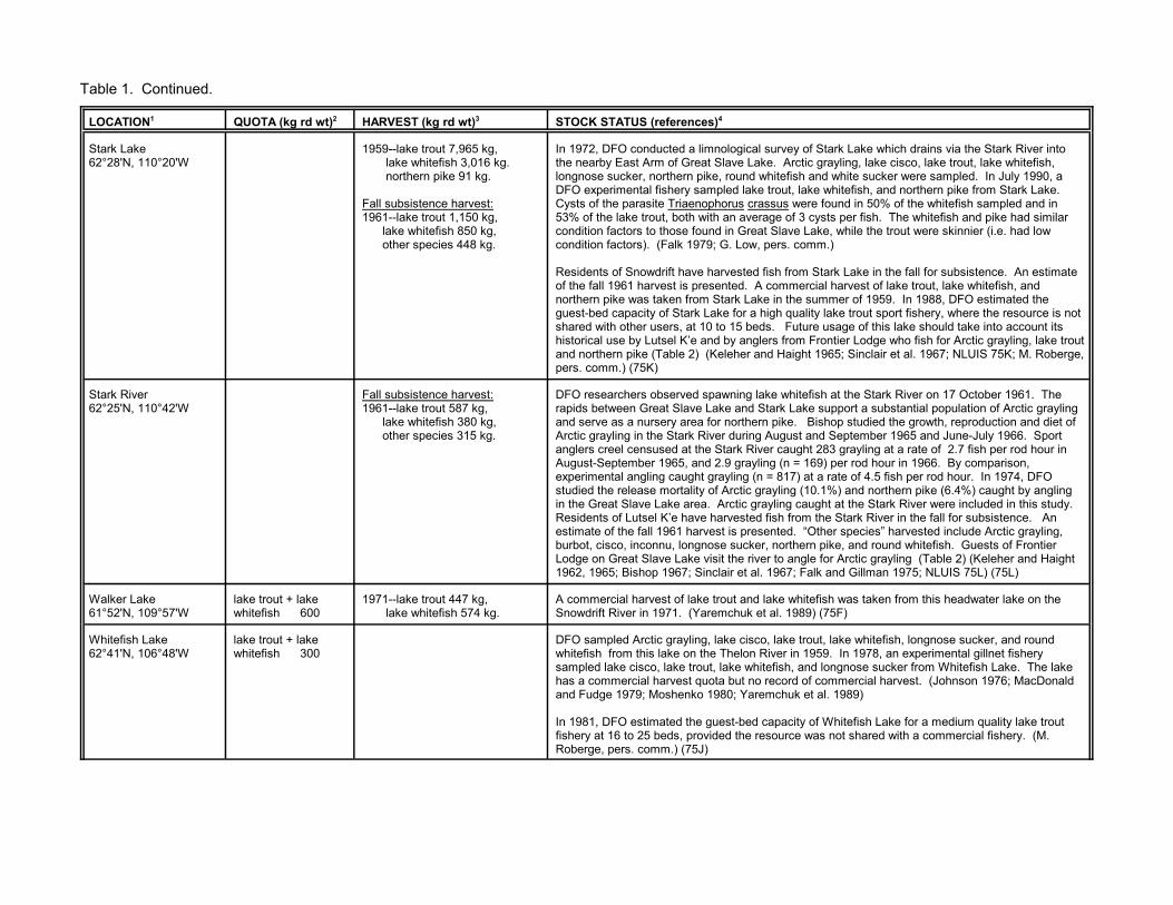
Table 1. Continued.
LOCATION1 QUOTA (kg rd wt)2 HARVEST (kg rd wt)3 STOCK STATUS (references)4
Stark Lake62°28'N, 110°20'W
1959--lake trout 7,965 kg, lake whitefish 3,016 kg. northern pike 91 kg.
Fall subsistence harvest:1961--lake trout 1,150 kg, lake whitefish 850 kg, other species 448 kg.
In 1972, DFO conducted a limnological survey of Stark Lake which drains via the Stark River intothe nearby East Arm of Great Slave Lake. Arctic grayling, lake cisco, lake trout, lake whitefish,longnose sucker, northern pike, round whitefish and white sucker were sampled. In July 1990, aDFO experimental fishery sampled lake trout, lake whitefish, and northern pike from Stark Lake. Cysts of the parasite Triaenophorus crassus were found in 50% of the whitefish sampled and in53% of the lake trout, both with an average of 3 cysts per fish. The whitefish and pike had similarcondition factors to those found in Great Slave Lake, while the trout were skinnier (i.e. had lowcondition factors). (Falk 1979; G. Low, pers. comm.)
Residents of Snowdrift have harvested fish from Stark Lake in the fall for subsistence. An estimateof the fall 1961 harvest is presented. A commercial harvest of lake trout, lake whitefish, andnorthern pike was taken from Stark Lake in the summer of 1959. In 1988, DFO estimated theguest-bed capacity of Stark Lake for a high quality lake trout sport fishery, where the resource is notshared with other users, at 10 to 15 beds. Future usage of this lake should take into account itshistorical use by Lutsel K’e and by anglers from Frontier Lodge who fish for Arctic grayling, lake troutand northern pike (Table 2) (Keleher and Haight 1965; Sinclair et al. 1967; NLUIS 75K; M. Roberge,pers. comm.) (75K)
Stark River62°25'N, 110°42'W
Fall subsistence harvest:1961--lake trout 587 kg, lake whitefish 380 kg, other species 315 kg.
DFO researchers observed spawning lake whitefish at the Stark River on 17 October 1961. Therapids between Great Slave Lake and Stark Lake support a substantial population of Arctic graylingand serve as a nursery area for northern pike. Bishop studied the growth, reproduction and diet ofArctic grayling in the Stark River during August and September 1965 and June-July 1966. Sportanglers creel censused at the Stark River caught 283 grayling at a rate of 2.7 fish per rod hour inAugust-September 1965, and 2.9 grayling (n = 169) per rod hour in 1966. By comparison,experimental angling caught grayling (n = 817) at a rate of 4.5 fish per rod hour. In 1974, DFOstudied the release mortality of Arctic grayling (10.1%) and northern pike (6.4%) caught by anglingin the Great Slave Lake area. Arctic grayling caught at the Stark River were included in this study. Residents of Lutsel K’e have harvested fish from the Stark River in the fall for subsistence. Anestimate of the fall 1961 harvest is presented. “Other species” harvested include Arctic grayling,burbot, cisco, inconnu, longnose sucker, northern pike, and round whitefish. Guests of FrontierLodge on Great Slave Lake visit the river to angle for Arctic grayling (Table 2) (Keleher and Haight1962, 1965; Bishop 1967; Sinclair et al. 1967; Falk and Gillman 1975; NLUIS 75L) (75L)
Walker Lake61°52'N, 109°57'W
lake trout + lakewhitefish 600
1971--lake trout 447 kg, lake whitefish 574 kg.
A commercial harvest of lake trout and lake whitefish was taken from this headwater lake on theSnowdrift River in 1971. (Yaremchuk et al. 1989) (75F)
Whitefish Lake62°41'N, 106°48'W
lake trout + lakewhitefish 300
DFO sampled Arctic grayling, lake cisco, lake trout, lake whitefish, longnose sucker, and roundwhitefish from this lake on the Thelon River in 1959. In 1978, an experimental gillnet fisherysampled lake cisco, lake trout, lake whitefish, and longnose sucker from Whitefish Lake. The lakehas a commercial harvest quota but no record of commercial harvest. (Johnson 1976; MacDonaldand Fudge 1979; Moshenko 1980; Yaremchuk et al. 1989)
In 1981, DFO estimated the guest-bed capacity of Whitefish Lake for a medium quality lake troutfishery at 16 to 25 beds, provided the resource was not shared with a commercial fishery. (M.Roberge, pers. comm.) (75J)

s)4
t no longer exists. It developed in the 1960's to support the Comincoantled in the late 1980's after being severely impacted by closure, ins mine. Water bodies utilized by community residents are discussed
es of Fort Resolution or Hay River (e.g. HAY RIVER--unnamed lake
inco Pine Point Mine discharged into muskeg and swampland about 5e. It was not acutely toxic to fish but did contain cyanide, copper, zinc,). Stein and Miller (1972) in the early 1970's and B.C. Research
creased metal concentrations in sediments and vegetation in the vicinityings area is now covered with a layer of gravel to prevent tailings dustw, pers. comm.). Residents of Fort Resolution have expressed
ants had entered, or were entering, the environment as a result of pastresponding to these concerns, Evans et al. (1998) studied metals in them the Resolution Bay area of Great Slave Lake in the vicinity of they did not find evidence of mine-related metal contamination. See also
rly Fort Reliance) harvested an estimated 4,090 kg of fish for59 to March 1960. Most of the people who lived at Reliance now live innce area only seasonally. See LUTSEL K’E section above for a the vicinity of Reliance. (Sinclair et al. 1967;NLUIS 75K)
ved. Square brackets indicate provisional test quotas. The quota years "NA" indicates that a harvest may have taken place but that no data are a blank quota cell, indicates that DFO has not assigned a commercialmmercial fishing opportunities in the waterbody or for that species.
ence harvests" were undertaken by residents for their own use,ort harvests" were taken by anglers.
f DFO Central and Arctic Region. References to "Table 4" are followedATUS” description denote the 1:250,000 scale map sheet (e.g. 75C)
Table 1. Continued.
LOCATION1 QUOTA (kg rd wt)2 HARVEST (kg rd wt)3 STOCK STATUS (reference
PINE POINT, NORTHWEST TERRITORIES (see FORT RESOLUTION and HAYRIVER)
The community of Pine Poinlead-zinc mine and was dism1987, of the once prosperouunder the nearby communiti[Polar Lake]).
The tailings pond at the Comkm south of Great Slave Lakand iron (Wallace et al. 1975(1978a) in 1977 observed inof the tailings pond. The tailfrom being wind borne (G. Loconcern that metal contaminmining operations. In 1996, water, sediments and fish frodecommissioned mine. TheTable 4--K. Steinecke.
RELIANCE, NORTHWEST TERRITORIES (see LUTSEL K’E) Residents of Reliance (formesubsistence from October 19Lutsel K’e and visit the Reliadescription of waterbodies in
STONY RAPIDS, SASKATCHEWAN (see BLACK LAKE)1 Old or alternate names for the fisheries are shown in brackets.
2 A round weight (kg rd wt) is that for a whole fish, while a dressed weight is that of a fish with the viscera and gills remoare the same as the federal government fiscal year (e.g. the 1998 quota extends from 1 April 1998 to 31 March 1999). available; "NF" indicates that a waterbody was opened for fishing by Variation Order but was not fished. "No quota", orquota to a waterbody, either as a whole or for a particular species. This does not necessarily mean that there are no co3 Unless otherwise noted the harvests were taken by commercial fisheries. The "Aboriginal food fisheries” and “subsist"experimental harvests" (formerly known as exploratory or test fisheries) were taken for scientific purposes, and the "sp
4 References to "DFO unpubl. data" denote information from the "Lake Files" held by Resource Management Section oby the name of the pertinent researcher as listed in Table 4. The alphanumeric codes at the end of each “STOCK STwhere the waterbody coordinates are located.
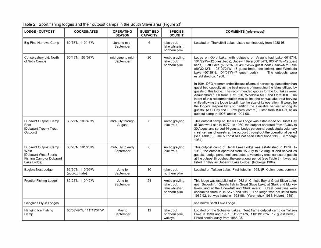
COMMENTS (references)2
li Lake. Listed continuously from 1988-98.
e, with outposts on Anaunethad Lake 60°57'N,eds), Dubawnt River ; 60°54'N, 103°41'W--12 guest°25'N, 104°07'W--6 guest beds), Snowbird Lake
'24W--16 guest beds, see below), and Wholdaia°08'W--7 guest beds). The outposts were.
ended the use of annual harvest quotas rather thans the best means of managing the lakes utilized by The recommended quotas for the four lakes were:ut, Flett 500, Wholdaia 500, and Obre 400. Theendation was to limit the annual lake trout harvestge to optimize the size of its operation. It would bebility to partition the available harvest among itsd G. Low, pers. comm.) Listed from 1989-91, as an, and in 1994-98.
Henik Lake Lodge was established on Outlet Bay977. In 1980, the outpost operated from 13 July to 44 guests. Lodge personnel conducted a voluntaryts at the outpost throughout the operational periodutpost has not been listed since 1988. (Roberge
f Henik Lake Lodge was established in 1979. Inerated from 15 July to 12 August and served 28nnel conducted a voluntary creel census of guestsout the operational period (see Table 3). It was lastawnt Lake Lodge. (Roberge 1984)
ake. First listed in 1998. (R. Colon, pers. comm.)
lished in 1962 on Christie Bay of Great Slave Lake,sts fish in Great Slave Lake, at Stark and Murkeyowdrift and Stark rivers. Creel censuses were972-75 and 1980. The lodge was not listed fromed in 1993-98. (Yaremchuk 1986; Hubert 1989)
Lodge
efer Lakes. Tent frame outpost camp on Taltson97 (61°22'14"N, 110°19'36"W; 12 guest beds). om 1988-98.
Table 2. Sport fishing lodges and their outpost camps in the South Slave area (Figure 2)1.
LODGE - OUTPOST COORDINATES OPERATINGSEASON
GUEST BEDCAPACITY
SPECIESSOUGHT
Big Pine Narrows Camp 60°58'N, 110°13'W June to mid-September
6 lake trout,lake whitefish,northern pike
Located on Thekulthi
Conservatory Ltd. Northof Sixty Camps
60°19'N, 103°07'W mid-June to mid-September
20 Arctic grayling,lake trout,northern pike
Lodge on Obre Lak104°29'W--12 guest bbeds), Flett Lake (60(60°32'12"N, 103°09Lake (60°39'N, 104established ca. 1988
In 1994, DFO recommguest bed capacity aguests of this lodge. Anaunethad 1000 trointent of this recommwhile allowing the lodthe lodge’s responsiguests. (A.C. Day anoutpost camp in 1993
Dubawnt Outpost CampEast[Dubawnt Trophy TroutOutpost]
63°27'N, 100°40'W mid-July throughAugust
6 Arctic grayling,lake trout
This outpost camp ofof Dubawnt Lake in 130 August and servedcreel census of gues(see Table 3). The o1984)
Dubawnt Outpost CampWest[Dubawnt West SportsFishing Camp or DubawntLake Lodge]
63°26'N, 101°26'W mid-July to earlySeptember
8 Arctic grayling,lake trout
This outpost camp o1980, the outpost opguests. Lodge persoat the outpost throughlisted in 1992 as Dub
Eagle’s Nest Lodge 62°30'N, 110°09'W(approximate)
June toSeptember
10 lake trout,northern pike
Located on Taltson L
Frontier Fishing Lodge 62°25'N, 110°42'W June toSeptember
24 Arctic grayling,lake trout,lake whitefish,northern pike
This lodge was estabnear Snowdrift. Guelakes, and at the Snconducted there in 11989-92, but was list
Gangler’s Fly-in Lodges see below Scott Lake
Hanging Ice FishingCamp
60°03'49"N, 111°19'34"W May toSeptember
12 lake trout,northern pike,walleye
Located on the SchaLake in 1990 and 19Listed continuously fr

Table 2. Continued.
LODGE - OUTPOST COORDINATES OPERATINGSEASON
GUEST BEDCAPACITY
SPECIESSOUGHT
COMMENTS (references)2
Kasba Lake Lodge 60°16'58"N, 102°30'25"W late JunethroughAugust
44 lake trout,Arctic grayling,northern pike
Kasba Lake extends into Nunavut but the lodge lies just west of Nunavut.Kasba Lake lodge was established in 1971. It operates outposts onSnowbird Lake (Snowbird Lodge, 60°29'36"N, 103°03'37"W, 18 guestbeds; Snowbird North 60°51'32"N, 102°38'17"W, 6 guest beds), andTubane Lake (in Nunavut at 60°37'44"N, 101°45'28"W, 6 guest beds). ADFO creel census of guests at Kasba Lake Lodge in 1979, estimated thetake trout harvest at 1,845 fish (3,692 kg). The lodge was listed annuallyfrom 1988-96, and in 1998.
Lady Grey Lake Outfitters 60°46'N, 110°35'W June to mid-September
6 lake trout,lake whitefish,northern pike
Located on Lady Grey Lake, this cabin establishment offers side trips toBig Pine Narrows Camp on Thekulthili Lake (see above). Listedcontinuously from 1988-98.
Largepike Lake Camp 60°07'N, 110°17'W 15 lake trout,northern pike
This lodge offers fishing, touring, and ecoventures in the Slave Riverarea. It was listed from 1990-93 and in 1997-98.
Lynx Tundra Camp 62°27'N, 106°17'W 12 Arctic grayling,lake trout,northern pike
Located on Lynx Lake. Last listed in 1992.
Morberg’s SmalltreeCamp
61°01'N, 105°02'W late-June tomid-September
4 Arctic grayling,lake trout,northern pike
Located at Smalltree Lake on the Dubawnt River. An outpost ofMorberg’s Lodge at Black Lake, Saskatchewan. Last listed in 1992.(NLUIS 75F)
Nonacho Lake FishingCamp
61°44'31"N, 109°37'15"W June to mid-September
32 lake trout,lake whitefish,northern pike
This lodge, established on Nonacho Lake ca. 1974, operates outpostcamps on Nonacho Lake (61°47'N, 109°17'W, 8 guest beds) and GagnonLake (61°58'N, 110°33'36"W--4 guest beds; 61°58'N, 110°27'55"W --3beds). It offered ice fishing in April 1982 and 1990, and was listedcontinuously from 1988-98.
Northstar Resort 61°40'N, 110°07'W June toSeptember
12 lake trout,lake whitefish,northern pike
Located on Thekulthili Lake. Listed continuously from 1988-98.
Pilot Lake Cabins 60°17'N, 110°57'W June toSeptember
15 lake trout,lake whitefish,northern pike,walleye
Located in the Pilot Lake/Taltson River area. Listed in 1988-93, 1995,and 1997-98.
Rocky Bay Fishing Lodge 61°36'N, 110°45'W mid-June to mid-September
10 lake trout,northern pike
Located on Rutledge Lake. Established ca. 1974 (DFO unpubl. data).Listed continuously from 1988-98.
Rutledge Lake Lodge 61°42'N, 110°40'W June to mid-September
12 lake trout,lake whitefish,northern pike
Located on Rutledge Lake. Established ca. 1974 (DFO unpubl. data).Listed continuously from 1988-98.

Table 2. Continued.
LODGE - OUTPOST COORDINATES OPERATINGSEASON
GUEST BEDCAPACITY
SPECIESSOUGHT
COMMENTS (references)2
Scott Lake Lodge 60°11'11"N, 106°00'29'W mid-June to mid-September
12 Arctic grayling,lake trout,northern pike
Located on Wignes Lake. Listed in 1988, 1995 (as Gangler’s Fly-inLodges), and 1996.
Snowbird Lake Lodge 60°32'12"N, 102°09'24"W mid-June to mid-September
16 Arctic grayling,lake trout,northern pike
Originally an outpost of Morberg’s Lodge at Black Lake, Saskatchewan,this lodge is now one of the Conservatory Ltd. North of Sixty Camps (seeabove). DFO conducted a complete creel census of Snowbird LakeLodge guests between 25 July and 3 September 1982. (See Table 3)(Bone et al. 1973; Roberge et al. 1984).
Thubun Lake Lodge 61°31'N, 111°46'W June toSeptember
22 lake trout,lake whitefish,northern pike
Located on Thubun Lake. Listed continuously from 1988-98.
Tukto Lodge 62°29'N, 103°17'W July and August 12 Arctic grayling,lake trout
Located at Mosquito Lake. Listed in 1988-93, 1995-96, and in 1998.
Whitewood Lodge 60°37'N, 109°58'W 8 Established ca. 1984. Located on Hill Island Lake. Not licensed in 1986.
1 The main sources of information for this table were the GNWT Economic Development and Tourism (S. Ranson, pers. comm.; D. Gray, pers. comm.), the GNWT Explorers Guides 1988-98, andDFO (C. Craig, pers. comm.). Other sources of information are referenced with the lodge to which they refer. Lodges located in communities or on the shores of Great Slave Lake, and outfittersoperating from communities or with moveable camps, are not listed. The outfitting operations are discussed in Table 1 with other information on the lakes that they frequent.2 Lodges "not listed" in a particular year were not advertised in the Explorers Guide in that year, and presumably were not in operation.

ve area, NWT.
COMMENTS (references)2
enik Lake Lodge was established on an island in Outlet Bay of Dubawntthe outpost operated from 13 July to 30 August and served 44 guests whotlet Bay area of the lake. Lodge personnel conducted a voluntary creel outpost for DFO. A total of 198 angler-interviews were conducted duringctic grayling and lake trout were the main species taken. These data areutpost was last listed in 1988. (Roberge 1984; NLUIS 65N)
enik Lake Lodge was established in 1979 . In 1980, the outpost operatedust and served 28 guests, who fished mainly at the north end of the lakege personnel conducted a voluntary creel census of guests at the outpost angler-interviews were conducted during the fishing season. Lake trouten. Harvest data are presented here. The outpost was last listed as 1992. (Roberge 1984; NLUIS 65N)
into Nunavut but the lodge lies just west of Nunavut. The lodge wasd operates outposts on Snowbird Lake (Snowbird Lodge, 60°29'36"N, beds; Snowbird North 60°51'32"N, 102°38'17"W, 8 guest beds), and inke (60°37'44"N, 101°45'28"W, 6 guest beds). DFO conducted a creel between 16 June and 31 August 1979. During the operating season theted 279 guests, who angled for lake trout near islands and bays in the mainhern pike near the lodge and at the mouth of the Snowbird River, and forowbird River. A total of 1,165 angler-interviews were conducted. Harvest presented here (Falk et al. 1982, Roberge et al. 1984). The lodge was
n 1998.
lete creel census of guests at Snowbird Lake Lodge between 25 July anduring the operating season the lodge, served 78 guests, who fished
total of 511 angler-interviews were conducted during the fishing season.ke, and Arctic grayling were the main species taken. Harvest data arege et al. 1984). In 1982, the Kazan River Lodge, located across the lakeowbird Lake Lodge was last listed in 1988. It is now operates as one ofh of Sixty Camps (Table 2). (Roberge et al. 1984; B. Dunn, pers. comm.)
died after being released (estimated at 7% by Falk et al. 1974). Thesen the vicinity of a lodge.
th moveable camps are not listed.
Table 3. A summary of harvest and creel census data from sport fishing lodges in the South Sla
SPECIESESTIMATED TOTAL
HARVEST (# of fish killed)1
AVERAGE NUMBEROF FISH CAUGHT
PER ANGLERHOUR
ESTIMATEDTOTAL NUMBER
OF ANGLER DAYS
DUBAWNT OUTPOST CAMP/EAST 63°27'N, 100°40'W This outpost camp of HLake in 1977. In 1980, fished mainly in the Oucensus of guests at thethe fishing season. Arpresented here. The o
Arctic grayling 1980--21 <0.1 198
lake trout 1980--305 1.6
DUBAWNT OUTPOST CAMP/WEST 63°26'N, 101°26'W This outpost camp of Hfrom 15 July to 12 Augwest of Outlet Bay. Lodfor DFO. A total of 131were the main fish takDubawnt Lake Lodge in
lake trout 1980--269 2.3 116
KASBA LAKE LODGE 60°16'N, 102°30'W Kasba Lake extends established in 1971 an103°03'37"W, 18 guestNunavut at Tubane Lacensus of lodge guestslodge served an estimapart of the lake, for nortArctic grayling in the Sndata from the study arelisted in 1988-96, and i
Arctic grayling 1979--346 0.3 1,542
lake trout 1979--1,846 1.5
northern pike 1979--69 0.1
SNOWBIRD LAKE LODGE 60°32'12"N, 103°09'24"W DFO conducted a comp3 September 1982. Dthroughout the lake. ALake trout, northern pipresented here (Roberwas not operating. SnConservatory Ltd. Nort
Arctic grayling 1982--60 0.2 511
lake trout 1982--255 0.5
northern pike 1982--71 0.3 1 Estimates of the total number of fish killed include fish retained ("kept") as trophies, eaten for shore lunches, and thatdata are based only on the lodge guests. They do not consider lodge employees or other who may have been fishing i2 Sources of information are referenced with the lodge to which they refer. Outfitters operating from communities or wi

ed by the Department of Fisheries and Oceans (DFO),hers. Note: DFO did not begin issuing licences to their
PURPOSE PERIOD
r the collection of various species of fin fish from any. Low).
1993,1994
val rates of stocked Arctic charr and rainbow trout in in conjunction with the GNWT Dept. of Renewable
1990,1991
recovery of the Buffalo River inconnu stock. 1990,1991
ata on lake trout, lake whitefish, and walleye from the 1990
y to assess stock status. 1990
r the collection of fish from any waterbody in the Greated northward to the northern boundary of the Sahtu
1995
r the collection of fish from any waterbody in the South assessment and/or stock identification, and fornal knowledge of stocks and fishing patterns. (See
1990,1996,1997
r the collection of fish from any waterbody in the South assessment and/or stock identification, and fornal knowledge of stocks and fishing patterns. (See
1995
es of inconnu from the Slave River near Fort Smith forudies of inconnu in the lower Mackenzie River area. -c; Howland 1997; Little 1997)
1994,1995,1996
Table 4. Licences to take fish from the South Slave area for scientific purposes issuCentral and Arctic Region, to DFO (1990-97) and non-DFO (1984-97) researcown fisheries programs until 1990.
LICENCE HOLDER AREA
DFO RESEARCHERS
B. HuntDFO, Yellowknife, NT
South Central Arctic General sampling program permit fowaterbody in the area. (See below G
G. LowDFO, Hay River, NT
Hay River area Investigation of the growth and survithe Hay River and Yellowknife areasResources.
Buffalo and Yatesrivers
Experimental fisheries to monitor the
Hay River and GreatSlave Lake
Collection of harvest and biological dcommercial fishery.
Hay River Monitoring of the walleye sport fisher
Mackenzie Riverdrainage
General sampling program permit foSlave Lake/Mackenzie River watershSettlement area.
NWT west area General sampling program permit foSlave area for the purposes of stockcommunity surveys to gather traditiobelow D. McKenna)
D. McKennaDFO, Yellowknife, NT
NWT west area General sampling program permit foSlave area for the purposes of stockcommunity surveys to gather traditioabove G. Low)
R.F. Tallman,DFO, Winnipeg, MB
Slave River Life history and developmental studicomparison with data from similar st(Tallman 1996; Tallman et al. 1996a

Table 4. Continued.
LICENCE HOLDER AREA PURPOSE PERIOD
NON-DFO RESEARCHERS
K. AntoniakThebacha College, Fort Smith, NT
Porter Lake area Winter collection of fish from the Porter Lake area (61°41'N, 108°05'W) for educationalpurposes by students of Arctic Colleges’ Renewable Resources Technology program.
1984
Tsu Lake Summer collection of fish for educational purposes by students of Arctic Colleges’Renewable Resources Technology program. (See below D. Bergmann, L. Gray, D.Langille, M. Rosen)
1984,1987
B. BergmannGNWT, Dept. of Renewable Resources,Fort Smith, NT
Tsu Lake Summer collection of fish for educational purposes by students of Arctic Colleges’Renewable Resources Technology program. (See above K. Antoniak and below L. Gray,D. Langille and M. Rosen)
1989
M.R. DigelGolder Associates Ltd.
Hay River Environmental baseline sampling of aquatic biota in the vicinity of Hay River (and north ofGreat Slave Lake in the vicinity of Thor Lake 62°06'N, 112°37'W) in preparation fordevelopment of the Highwood Resources Thor Lake Beryllium Project.
1997
M. EvansNational Hydrological Research Institute,Saskatoon, SK
Slave River delta,Lutsel’ke
Collection of fish for the determination of organochlorine and metal residues in predatoryfish in the Fort Resolution and Lutsel’ke areas.
1994,1995
Little Buffalo Riverdelta, Slave Riverdelta
Collection of burbot, inconnu, northern pike, and walleye for the determination oforganochlorine and metal residues in predatory fish within the Fort Resolution domesticfishing zone.
1996
D. FreyAlberta Power Ltd., Edmonton, AB
Slave River An investigation of fall and winter-spawning fish species in the Slave River between FortSmith and Great Slave Lake. This project was a component of the environmental studiesrelating to potential hydroelectric development of the Slave River. Its purposes were tostudy fish movements, identify spawning areas, quantify late summer and fall fisheryresource use, and to examine the movements and domestic utilization of burbot. (RL&L/EMA Slave River Joint Venture 1985)
1984
L. Gray Thebacha College, Fort Smith, NT
Tsu Lake Summer collection of fish for educational purposes by students of Arctic Colleges’Renewable Resources Technology program. (See above K. Antoniak and D. Bergmann,and below D. Langille and M. Rosen)
1992
D. LangilleThebacha College, Fort Smith, NT
Tsu Lake Summer collection of fish for educational purposes by students of Arctic Colleges’Renewable Resources Technology program. (See above K. Antoniak and D. Bergmann,and below M. Rosen)
1985,1986
A.C. MitchellEnvirocon Ltd., Vancouver, BC
Taltson River area Study to assess the impacts on fish populations of predicted effects associated with theexisting hydroelectric facility and possible future facilities on the mainstem of the TaltsonRiver. (Envirocon Pacific Limited 1986)
1985

Table 4. Continued.
LICENCE HOLDER AREA PURPOSE PERIOD
M. RosenThebacha College, Fort Smith, NT
Slave River Collection of fish for educational purposes by students of Arctic Colleges’ RenewableResources Technology program. (See above K. Antoniak, D. Bergmann, L. Gray, and D.Langille)
1991
east of Slave River Collection of fish for educational purposes by students of Arctic Colleges’ RenewableResources Technology program. (See above K. Antoniak, D. Bergmann, L. Gray, and D.Langille)
1992
Tsu Lake Summer collection of fish for educational purposes by students of Arctic Colleges’Renewable Resources Technology program. (See above K. Antoniak, D. Bergmann, L.Gray, and D. Langille)
1991
K. SteineckeDept. of GeographyUniversity of Bremen, Germany
Pine Point Collection of aquatic invertebrates from waters in the vicinity Pine Point as part of a studyto examine the reactions of northern boreal forest ecosystems in the Great Slave Lakeregion to the man-made stress of mining and related activities.
1997
D.M. TrotterMonenco Consultants Ltd., Calgary, AB
Sawmill Bay area ofthe Slave River
Environmental monitoring of the Sawmill Bay area of the Slave River, NT. (Monenco 1991) 1990
H. WestersDept. of Natural Resources,Lansing, Michigan
Hay River area Collection of Arctic grayling eggs and sperm for rearing and re-introduction of the speciesinto Michigan waters.
1988

from Great Slave Lake (Fig. 1).
HUDSON BAY
IVER CHESTERFIELD INLET via BAKER LAKE
llieer)
KazanRiver(9)
DubawntRiver(10)
ThelonRiver(11)
k R.) - p -
P P P
- - -
- - -
- - -
P P P
- - -
- - -
- - -
- - -
- - -
- - -
- - -
- - -
- - -
P P P
Appendix 1. Fish species reported from selected river drainages in the South Slave area of the N.W.T., and See below for footnotes and references.
FISH SPECIES
ARCTIC OCEAN
MACKENZIE RIVER via GREAT SLAVE LAKE BACK R
GreatSlave Lake
(A)
Hay River(1)
BuffaloRiver(2)
Little BuffaloRiver(3)
SlaveRiver(4)
TaltsonRiver(5)
SnowdriftRiver(6)
LockhartRiver(7)
BaiRiv(8
Arctic charr (Salvelinus alpinus)
- - S3 - - - - - -(Bac
Arctic grayling (Thymallus arcticus)
P1 P - - P P P P P
Arctic lamprey (Lampetra japonica)
P P - - P2 - - P -
brook sticklebackCulea inconstans
- P P P P2 - - - -
brook troutSalvelinus fontinalis
- - S3 - - - - - -
burbot (Lota lota)
P P P P P2 P P P -
chinook salmon(Onchorhynchus tshawytsha)
- - - - P - - - -
chum salmon(Onchorhynchus keta)
P P - - P - - - -
deepwater sculpin(Myoxocephalus quadricornisthompsoni)
P - - - - - - - -
emerald shiner(Notropis atherinoides)
P - - - P2 - - - -
fathead minnnowPimephales promelas
- - - P - - - - -
finescale daceChrosomus neogaeus
- P - P - - - - -
flathead chub (Platygobio gracilis)
P - - - P2 - - - -
goldeye (Hiodon alosoides)
P - - - P2 P - - -
inconnu (Stenodus leucichthys)
P P P P P2 P - - -
lake chub (Couesius plumbeus)
P P P P P P - - -
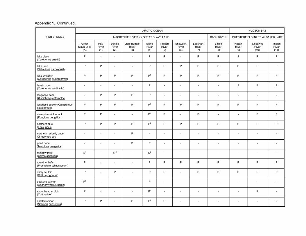
Appendix 1. Continued.
FISH SPECIES
ARCTIC OCEAN HUDSON BAY
MACKENZIE RIVER via GREAT SLAVE LAKE BACK RIVER CHESTERFIELD INLET via BAKER LAKE
GreatSlave Lake
(A)
Hay River(1)
BuffaloRiver(2)
Little BuffaloRiver(3)
SlaveRiver(4)
TaltsonRiver(5)
SnowdriftRiver(6)
LockhartRiver(7)
BaillieRiver(8)
KazanRiver(9)
DubawntRiver(10)
ThelonRiver(11)
lake cisco (Coregonus artedii)
P - - - P P - P P ? P P
lake trout (Salvelinus namaycush)
P P - - P P P P P P P P
lake whitefish (Coregonus clupeaformis)
P P P P P2 P P P P P P P
least cisco (Coregonus sardinella)
- - - - P - - - - ? P P
longnose daceRhynichthys cataractae
- P P P P - - - - - - -
longnose sucker (Catostomuscatostomus)
P P P P P2 P P P P P P P
ninespine stickleback(Pungitius pungitius)
P P - - P2 P - P - - P P
northern pike (Esox lucius)
P P P P P2 P P P P P P P
northern redbelly daceChrosomus eos
- - - P - - - - - - - -
pearl daceSemotilus margarita
- - - P P - - - - - - -
rainbow trout(Salmo gairdneri)
S4 - S3,4 - S2 - - - - - - -
round whitefish (Prosopium cylindraceum)
P - - - P P P P P P P P
slimy sculpin (Cottus cognatus)
P - P - P P - P P P P P
sockeye salmon(Onchorhynchus nerka)
P5 - - - P - - - - - - -
spoonhead sculpin(Cottus ricei)
P - - - P2 - - - - - P -
spottail shiner (Notropis hudsonius)
P P - P P2 P - - - - - -

Appendix 1. Continued.
FISH SPECIES
ARCTIC OCEAN HUDSON BAY
MACKENZIE RIVER via GREAT SLAVE LAKE BACK RIVER CHESTERFIELD INLET via BAKER LAKE
GreatSlave Lake
(A)
Hay River(1)
BuffaloRiver(2)
Little BuffaloRiver(3)
SlaveRiver(4)
TaltsonRiver(5)
SnowdriftRiver(6)
LockhartRiver(7)
BaillieRiver(8)
KazanRiver(9)
DubawntRiver(10)
ThelonRiver(11)
trout perch (Percopsis omiscomaycus)
P P P - P2 P - - - - - -
walleye (Stizostedion vitreum vitreum)
P P P P P2 P P - - - - -
white sucker (Catastomus commersoni)
P P - P P2 P - P - P P -
yellow perch(Perca flavescens)
P - - - P P - - - - - -
1 "P" indicates that a fish species has been reported to occur in a particular river drainage or lake. "-" indicates that we did not find a report of the species occurring within the South Slave area in a particulardrainage basin. "S" indicates that the species has been stocked in lakes within the drainage basin.
2 These fish species are present in the Salt River tributary of the Slave River.
3 Brook trout, rainbow trout, and Arctic charr were introduced to Polar Lake (see Table 1)--the latter may in fact be Dolly Varden (Salvelinus malma).4 These rainbow trout may have been introduced by anglers from isolated, stocked lakes such as “Polar Lake” near Pine Point (see Table 1: HAY RIVER--unnamed lake [Polar Lake]), or have come down theSlave River (G. Low, pers. comm.).
5 Two non-anadromous sockeye were taken in the Hardisty area and may have originated in the Slave River drainage (G. Low, pers. comm.).
REFERENCES:
A) GREAT SLAVE LAKE McPhail and Lindsey 1970; Scott and Crossman 1973; Lee et al. 1980; G. Low, pers. comm. 1) Hay River Harris 1962; McPhail and Lindsey 1970; Nursall and Buchwald 1972; Scott and Crossman 1973; Lee et al. 1980; McLeod and O’Neil 1983; G. Low, pers. comm. 2) Buffalo River Melvill 1914; McPhail and Lindsey 1970; Nelson and Paetz 1972; Lee et al. 1980; G. Low, pers. comm. 3) Little Buffalo River Nelson and Paetz 1972; Roberge et al. 1985. 4) Slave River Melvill 1914; McPhail and Lindsey 1970; Nelson and Paetz 1972; Nursall and Buchwald 1972; Scott and Crossman 1973; Lee et al. 1980; Tripp et al 1981; McLeod and O’Neil
1983;RL&L/EMA Slave River Joint Venture 1985; McCart 1986; Tallman et al. 1996; Little 1997; G. Low, pers. comm. 5) Taltson River Critchell-Bullock 1931; McPhail and Lindsey 1970; Johnson 1976; Envirocon Limited et al. 1975; MacDonald and Fudge 1979; Envirocon Pacific Limited 1986. 6) Snowdrift River Keleher and Haight 1962; Kennedy 1963; NLUIS 75K. 7) Lockhart River Critchell-Bullock 1931; Clarke 1940; McPhail and Lindsey 1970; Nursall and Buchwald 1972; Scott and Crossman 1973; Stewart and MacDonald 1978; MacDonald and Fudge
1979; Lee et al. 1980. 8) Baillie River Stewart and MacDonald 1978. 9) Kazan River McPhail 1963; McPhail and Lindsey 1970; Khan and Quadri 1971; McCart and Pepper 1971; Johnson 1976; MacDonald and Fudge 1979; Falk et al. 1982. 10) Dubawnt River Tyrell 1896; Laird 1961; McPhail 1963; McPhail and Lindsey 1970; Khan and Quadri 1971; McCart and Pepper 1971; Scott and Crossman 1973; Johnson 1976; MacDonald and
Fudge 1979; Roberge 1984; Roberge et al. 1984; Roberge and Dunn 1985. 11) Thelon River Critchell-Bullock 1931; McPhail 1963; McPhail and Linsdsey 1970; Khan and Quadri 1971; Johnson 1976; MacDonald and Fudge 1979; MacDonald and Stewart 1980.