Embed Size (px)
Citation preview
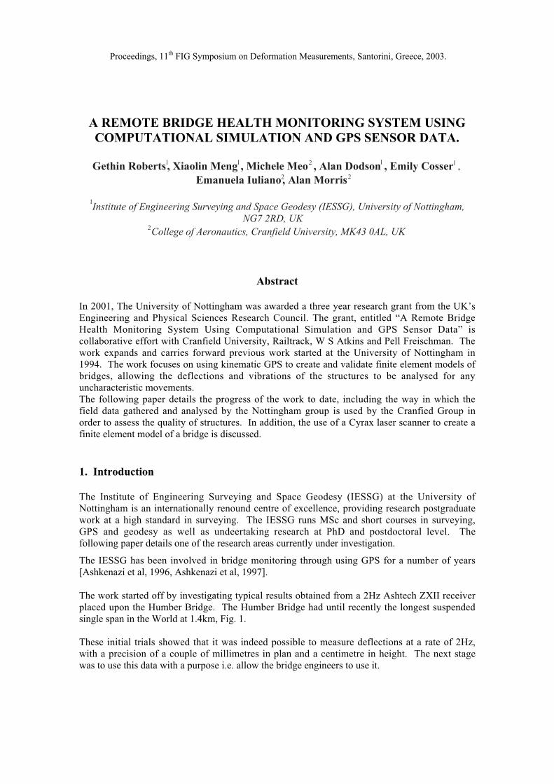
A REMOTE BRIDGE HEALTH MONITORING SYSTEM USINGCOMPUTATIONAL SIMULATION AND GPS SENSOR DATA.
Gethin Roberts1, Xiaolin Meng1, Michele Meo2 , Alan Dodson1 , Emily Cosser1 ,Emanuela Iuliano2, Alan Morris2
1Institute of Engineering Surveying and Space Geodesy (IESSG), University of Nottingham,
NG7 2RD, UK2College of Aeronautics, Cranfield University, MK43 0AL, UK
Abstract
In 2001, The University of Nottingham was awarded a three year research grant from the UK’sEngineering and Physical Sciences Research Council. The grant, entitled “A Remote BridgeHealth Monitoring System Using Computational Simulation and GPS Sensor Data” iscollaborative effort with Cranfield University, Railtrack, W S Atkins and Pell Freischman. Thework expands and carries forward previous work started at the University of Nottingham in1994. The work focuses on using kinematic GPS to create and validate finite element models ofbridges, allowing the deflections and vibrations of the structures to be analysed for anyuncharacteristic movements.The following paper details the progress of the work to date, including the way in which thefield data gathered and analysed by the Nottingham group is used by the Cranfied Group inorder to assess the quality of structures. In addition, the use of a Cyrax laser scanner to create afinite element model of a bridge is discussed.
1. Introduction
The Institute of Engineering Surveying and Space Geodesy (IESSG) at the University ofNottingham is an internationally renound centre of excellence, providing research postgraduatework at a high standard in surveying. The IESSG runs MSc and short courses in surveying,GPS and geodesy as well as undeertaking research at PhD and postdoctoral level. Thefollowing paper details one of the research areas currently under investigation.
The IESSG has been involved in bridge monitoring through using GPS for a number of years[Ashkenazi et al, 1996, Ashkenazi et al, 1997].
The work started off by investigating typical results obtained from a 2Hz Ashtech ZXII receiverplaced upon the Humber Bridge. The Humber Bridge had until recently the longest suspendedsingle span in the World at 1.4km, Fig. 1.
These initial trials showed that it was indeed possible to measure deflections at a rate of 2Hz,with a precision of a couple of millimetres in plan and a centimetre in height. The next stagewas to use this data with a purpose i.e. allow the bridge engineers to use it.
Proceedings, 11th FIG Symposium on Deformation Measurements, Santorini, Greece, 2003.
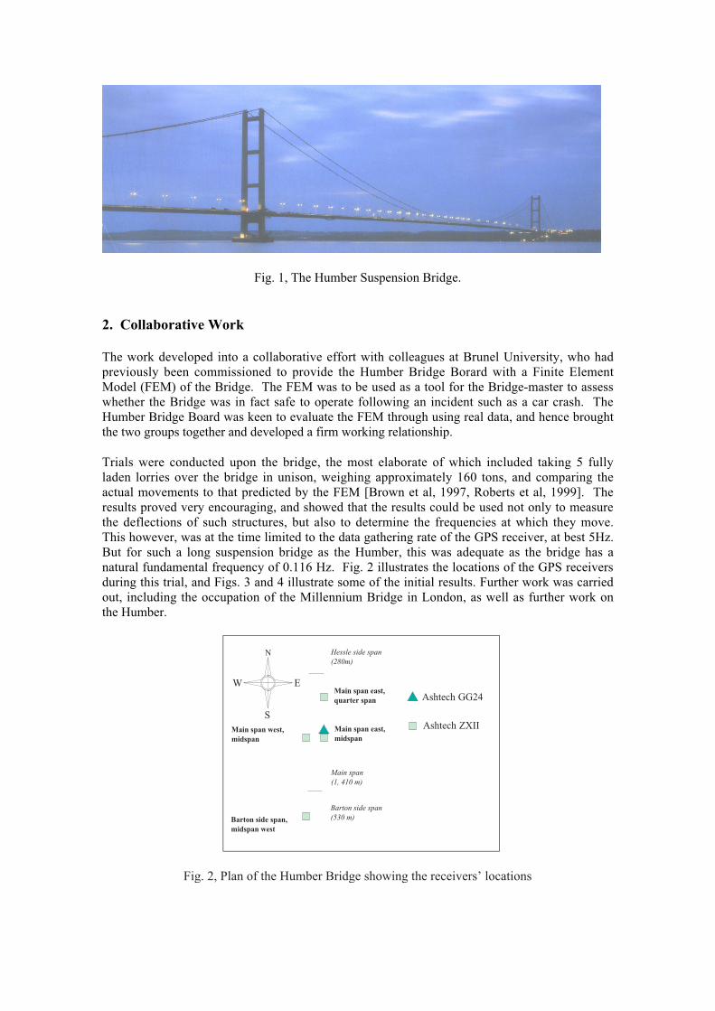
Fig. 1, The Humber Suspension Bridge.
2. Collaborative Work
The work developed into a collaborative effort with colleagues at Brunel University, who hadpreviously been commissioned to provide the Humber Bridge Borard with a Finite ElementModel (FEM) of the Bridge. The FEM was to be used as a tool for the Bridge-master to assesswhether the Bridge was in fact safe to operate following an incident such as a car crash. TheHumber Bridge Board was keen to evaluate the FEM through using real data, and hence broughtthe two groups together and developed a firm working relationship.
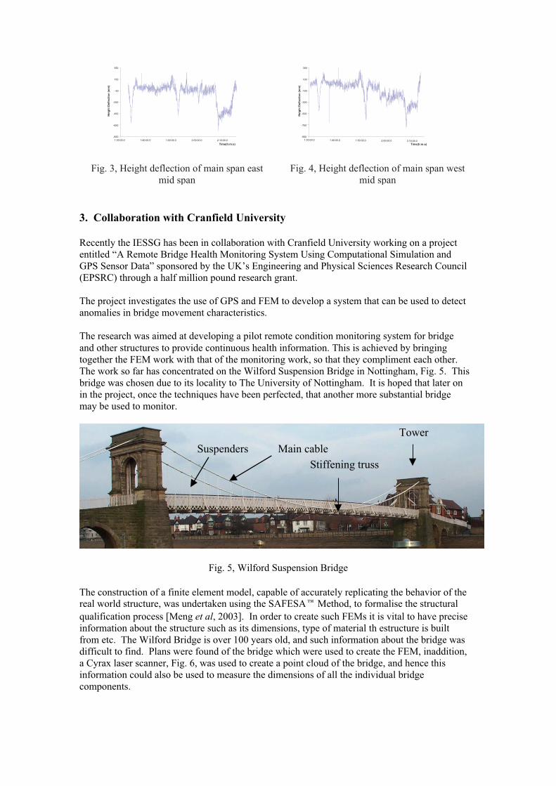
Trials were conducted upon the bridge, the most elaborate of which included taking 5 fullyladen lorries over the bridge in unison, weighing approximately 160 tons, and comparing theactual movements to that predicted by the FEM [Brown et al, 1997, Roberts et al, 1999]. Theresults proved very encouraging, and showed that the results could be used not only to measurethe deflections of such structures, but also to determine the frequencies at which they move.This however, was at the time limited to the data gathering rate of the GPS receiver, at best 5Hz.But for such a long suspension bridge as the Humber, this was adequate as the bridge has anatural fundamental frequency of 0.116 Hz. Fig. 2 illustrates the locations of the GPS receiversduring this trial, and Figs. 3 and 4 illustrate some of the initial results. Further work was carriedout, including the occupation of the Millennium Bridge in London, as well as further work onthe Humber.
Barton side span(530 m)
Main span(1, 410 m)
Hessle side span(280m)
Main span east,quarter span
Main span east,midspan
Main span west,midspan
Barton side span,midspan west
Ashtech GG24
Ashtech ZXII
N
E
S
W
Fig. 2, Plan of the Humber Bridge showing the receivers’ locations
-850
-650
-450
-250
-50
150
350
1:30:00.0 1:40:00.0 1:50:00.0 2:00:00.0 2:10:00.0
Time(h:m:s)
Hei
gh
t D
efle
ctio
n (
mm
)
-900
-700
-500
-300
-100
100
300
1:30:00.0 1:40:00.0 1:50:00.0 2:00:00.0 2:10:00.0Time(h:m:s)
Hei
gh
t D
efle
ctio
n (
mm
)
Fig. 3, Height deflection of main span eastmid span
Fig. 4, Height deflection of main span westmid span
3. Collaboration with Cranfield University
Recently the IESSG has been in collaboration with Cranfield University working on a projectentitled “A Remote Bridge Health Monitoring System Using Computational Simulation andGPS Sensor Data” sponsored by the UK’s Engineering and Physical Sciences Research Council(EPSRC) through a half million pound research grant.
The project investigates the use of GPS and FEM to develop a system that can be used to detectanomalies in bridge movement characteristics.
The research was aimed at developing a pilot remote condition monitoring system for bridgeand other structures to provide continuous health information. This is achieved by bringingtogether the FEM work with that of the monitoring work, so that they compliment each other.The work so far has concentrated on the Wilford Suspension Bridge in Nottingham, Fig. 5. Thisbridge was chosen due to its locality to The University of Nottingham. It is hoped that later onin the project, once the techniques have been perfected, that another more substantial bridgemay be used to monitor.
Fig. 5, Wilford Suspension Bridge
The construction of a finite element model, capable of accurately replicating the behavior of thereal world structure, was undertaken using the SAFESA Method, to formalise the structuralqualification process [Meng et al, 2003]. In order to create such FEMs it is vital to have preciseinformation about the structure such as its dimensions, type of material th estructure is builtfrom etc. The Wilford Bridge is over 100 years old, and such information about the bridge wasdifficult to find. Plans were found of the bridge which were used to create the FEM, inaddition,a Cyrax laser scanner, Fig. 6, was used to create a point cloud of the bridge, and hence thisinformation could also be used to measure the dimensions of all the individual bridgecomponents.
Main cableSuspenders
Tower
Stiffening truss
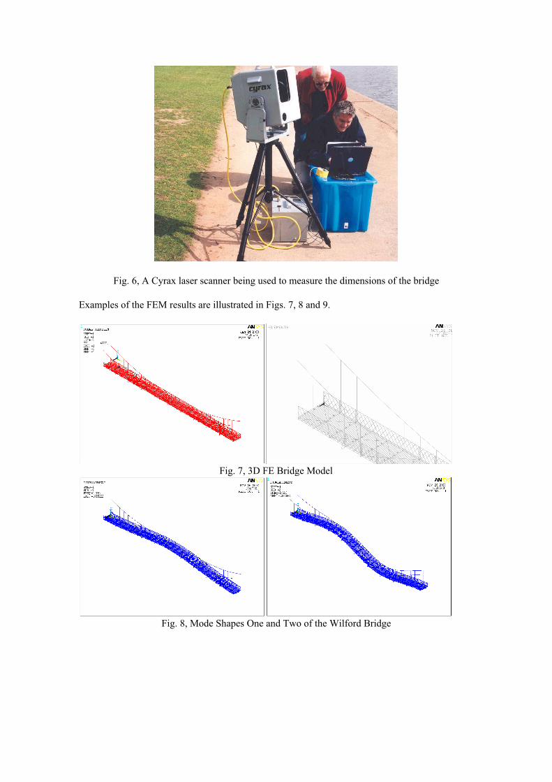
Fig. 6, A Cyrax laser scanner being used to measure the dimensions of the bridge
Examples of the FEM results are illustrated in Figs. 7, 8 and 9.
Fig. 7, 3D FE Bridge Model
Fig. 8, Mode Shapes One and Two of the Wilford Bridge
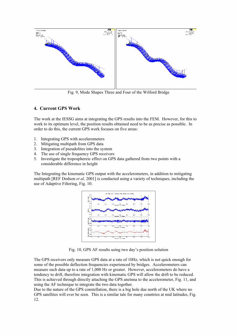
Fig. 9, Mode Shapes Three and Four of the Wilford Bridge
4. Current GPS Work
The work at the IESSG aims at integrating the GPS results into the FEM. However, for this towork to its optimum level, the position results obtained need to be as precise as possible. Inorder to do this, the current GPS work focuses on five areas:
1. Integrating GPS with accelerometers2. Mitigating multipath from GPS data3. Integration of pseudolites into the system4. The use of single frequency GPS receivers5. Investigate the troposphereic effect on GPS data gathered from two points with a
considerable difference in height
The Integrating the kinematic GPS output with the accelerometers, in addition to mitigatingmultipath [REF Dodson et al, 2001] is conducted using a variety of techniques, including theuse of Adaptive Filtering, Fig. 10.
Fig. 10, GPS AF results using two day’s position solution
The GPS receivers only measure GPS data at a rate of 10Hz, which is not quick enough forsome of the possible deflection frequencies experienced by bridges. Accelerometers canmeasure such data up to a rate of 1,000 Hz or greater. However, accelerometers do have atendency to drift, therefore integration with kinematic GPS will allow the drift to be reduced.This is achieved through directly attaching the GPS anetnna to the accelerometer, Fig. 11, andusing the AF technique to integrate the two data together.Due to the nature of the GPS constellation, there is a big hole due north of the UK where noGPS satellites will ever be seen. This is a similar tale for many countries at mid latitudes, Fig.12.

Fig. 11, The accelerometer and GPS antenna co-located
Fig. 12, A sky plot of Nottingham showing a hole in the GPS satellite constellation
One way to overcome this issue, as well as to improve the height component of the results, isaugment the GPS with pseudolites. The researchers at the University of Nottingham have, incollaboration with colleagues at the University of New South Wales, been investigating this. Sofar, the research has been focused on obtaining good results from the pseudolites, and applyingthem onto structures, notable at Nottingham and at Sydney. The results to date look promising.
Fourthly, the focus of the GPS research is to incorporate single frequency code/carrier GPSreceivers into such research, with small lightweight antennas, hence reducing the cost of asystem based on using dual frequency receivers with choke ring antennas. As the bridge is notmoving, a full on the fly search is not vital, as the system should have a good idea of theantennas location. Furthermore, research is underway looking at the possibility of applying theknowledge of the ionospheric errors present in a dual frequency GPS receiver, and applying thisto a single frequency receiver’s L1 data to create virtual L2 data. So far, this has shown to bepossible, but does have limitations [Meng et al, 2002].
Many structures result in the GPS receivers at the reference station and at the rover stationhaving a considerable difference in altitude. Research is underway investigating the effect thetroposphere has on the results from such a scenario [Roberts et al, 2001]. Again, the results doshow that there is a need to be aware and calculate such effects.
5. Conclusions
The paper has tried to bring the reader up to date with the ongoing work at The University ofNottingham in bridge monitoring by GPS. Due to the extent of this work, the paper has onlybeen able to outline the different areas, but has tried to point the reader in the right direction forfurther references.
Acknowledgements
The authors would like to express their thanks to the UK_s Engineering and Physical SciencesResearch Council (EPSRC) for providing the grant for this project. Colleagues from CranfieldUniversity, Leica Geosystems Ltd (UK), Railtrack and W S Atkins are acknowledged for theirmany invaluable suggestions. The authors acknowledge the assistance of other staff member atthe IESSG during the bridge trials.
References
Ashkenazi, V., Dodson, A. H., Moore, T., Roberts, G. W. (1996) Real Time OTF GPSMonitoring of the Humber Bridge, Surveying World, May/June 1996, Vol. 4, Issue 4,ISSN 0927-7900, pp 26-28.
Ashkenazi, V., Dodson, A. H., Moore, T., Roberts, G W. (1997) Monitoring the HumberSuspension Bridge by GPS, Proc GNSS ‘97, First European Symposium on GlobalNavigation Satellite Systems, pp 553 - 560, Munich, April 1997.
Brown, C. J., Karuna, R., Ashkenazi, V., Roberts, G. W., Evans, R. (1999) Monitoring ofStructures using GPS, Proc Institution of Civil Engineers, Structures, ISSN 0965 092X,pp 97 - 105, February 1999.
Dodson A. H., Meng X., Roberts G. W., (2001) Adaptive FIR Filtering for Multipath Mitigationand its Application for Alrge Structural Deflection Monitoring. Proc InternationalSymposium on kinematic Systems in Geodesy, Geomatics and Navigation (KIS 2001),Banff, Canada, 5 – 8 June 2001.
Meng X., Meo M., Roberts G. W., Dodson A. Cosser E., Iuliano E., Morris A. (2003)Validating GPS Based Bridge Deformation Monitoring with Finite Element Model.Presented at the GNSS2003 conference May 2003, Gratz, Austria.
Meng, X., Roberts, G., Cosser, E., Dodson, A., (2002) Creating Virtual L2 GPS Data Using aCombination of L1 Receivers and L1/L2 Reference Receivers. Presented at The 15thInternational Technical Meeting of the Satellite Division of the Institute of Navigation,Portland, Oregon, USA, September 2002.
Roberts, G. W., Dodson, A. H., Ashkenazi, V., Brown, C. J., Karuna, R., Evans, R. (1998)Comparison of GPS Measurements and Finite Element Modelling for DeformationMeasurements of the Humber Bridge, Proc ION-GPS-99, The 12th InternationalTechnical Meeting of the Satellite Division of the Institute of Navigation, 8 pages,Nashville, USA, September 1999.
Roberts G. W., Meng X., Dodson A. H., (2001) Data Processing and and Multipath MitigationApproaches for GPS/Accelerometer Based Hybrid Structural Deflection MonitoringSystem, Proc ION-GPS-01, The 14th International Technical Meeting of the SatelliteDivision of the Institute of Navigation, Salt Lake City, USA, September 2001.