Embed Size (px)
Citation preview
TS5.8 Problems Related to the Use of GPSStefan Willgalis, Günter Seeber, Cláudia Pereira Krueger, Verônica M.C. RomãoA Real Time GPS Reference Network for Recife, Brazil, Enabeling Precise and Reliable Cadastral Surveys
FIG XXII International CongressWashington, D.C. USA, April 19-26 2002
1/15
A Real Time GPS Reference Network for Recife, Brazil,Enabling Precise and Reliable Cadastral Surveys
Stefan WILLGALIS and Prof. Günter SEEBER, Germany and Prof. Cláudia PereiraKRUEGER and Prof. Verônica M.C. ROMÃO, Brazil
Key words: Precise Real Time GPS Positioning, RTK Networks, Active Reference Frames.
ABSTRACT
The establishment and maintenance of geodetic reference frames which are an essential foun-dation for all surveys related to land management, GIS and large scale mapping are very ex-pensive. Large countries like Brazil cannot afford a dense, nation-wide control network.Active GPS reference stations provide an alternative concept for reference frames. Becauseof the high potential of relative, carrier phase based GPS measurements it is sufficient, to tieGPS surveys to the next reference station with precisely known coordinates. The connectionto adjacent control monuments is not required as long as network distortions can be eitherneglected or modelled. Therefore the effort for a classical monumented networks can be re-duced drastically.
For those applications requiring sub decimetre or even centimetre-level accuracy in real time,the working radius of a field station is limited to less than 10 km from the next reference sta-tion, especially in the equatorial region. To overcome this unsatisfactory situation, the spatialand temporal correlations of GPS measurement errors introduced by ionosphere, troposphere,and satellite orbit need to be modelled in a real time multi station solution. A concept for sucha local GPS reference network covering only densely populated areas or an important eco-nomic region has been developed in a collaborative Brazilian-German research project.
In the paper, we discuss the set up of a local GPS reference network that was operated in theurban area of Recife during November 2000, and positioning results for control and cadastralsurveys are given. The real time multi station solutions yield more precise, more reliable, andmuch faster results, but are still limited by strong ionospheric anomalies.
RESUMO
A implantação e manutenção de redes de referência geodésicas, essenciais para todos oslevantamentos relacionados ao gerenciamento territorial, GIS e mapeamento em escalasgrandes, são muito dispendiosas. Países com grandes extensões territoriais, como o Brasil,não tem condições de desenvolver uma rede de controle ampla e densa em todo seu território.Estações GPS ativas fornecem um conceito alternativo para redes de referência. Devido aoalto potencial das medições GPS de fase das portadoras, é suficiente amarrar oslevantamentos GPS a uma estação de referência próxima com coordenadas precisamenteconhecidas. A conexão a um marco de controle adjacente não é requerida quando as
TS5.8 Problems Related to the Use of GPSStefan Willgalis, Günter Seeber, Cláudia Pereira Krueger, Verônica M.C. RomãoA Real Time GPS Reference Network for Recife, Brazil, Enabeling Precise and Reliable Cadastral Surveys
FIG XXII International CongressWashington, D.C. USA, April 19-26 2002
2/15
distorções na rede podem ser negligenciadas ou modeladas. Desta forma, os esforços parauma monumentação clássica de redes podem ser drasticamente reduzidos.
Para aplicações que requerem precisão em tempo real em nível sub decimétrico ou mesmocentimétrico, o raio de aplicação é limitado a menos de 10 km da estação de referência,especialmente em regiões equatoriais. Para contornar essa situação, as correlações temporaise espaciais dos erros de medição GPS, introduzidos pela ionosfera, troposfera e órbita dossatélites, precisam ser modelados através de uma solução de múltiplas estações em temporeal. Um conceito para um tipo de rede de referência GPS, cobrindo áreas populosas ouregiões economicamente importantes, foi desenvolvido dentro de um projeto de pesquisabilateral Brasil-Alemanha.
Neste trabalho é discutida a instalação de uma rede de referência que foi operada durante omês de Novembro de 2000 na área urbana de Recife, e os resultados dos levantamentoscadastrais e de pontos de controle são apresentados. As soluções de múltiplas estações emtempo real produzem maior precisão, maior confiabilidade e soluções mais rápidas, masainda são limitadas pelas fortes anomalias ionosféricas.
CONTACT
Dipl.-Ing. Stefan Willgalis and Prof. Dr.-Ing. Günter SeeberInstitut für ErdmessungUniversität HannoverSchneiderberg 5030167 HannoverGERMANYTel. + 49 511 762 5149Fax + 49 511 762 4006E-mail: [email protected] and [email protected]
Profa. Dr. Cláudia Pereira KruegerDepartamento de Geomática, Universidade Federal do Paraná (UFPR)Centro Politécnico, Jardim das Américas, CuritbaCEP 81531-990, ParanáBRAZILTel. + 55 41 361 3064Fax + 55 41 266 2393E-mail: [email protected]
Profa. Dr. Verônica M.C. RomãoDepartamento de Engenharia Cartográfica, Universidade Federal de Pernambuco (UFPE)Av. Acadèmico Hélio Ramos, RecifeCEP 50740-530, PernambucoBRAZILTel. /Fax + 55 81 271 8235E-mail: [email protected]
TS5.8 Problems Related to the Use of GPSStefan Willgalis, Günter Seeber, Cláudia Pereira Krueger, Verônica M.C. RomãoA Real Time GPS Reference Network for Recife, Brazil, Enabeling Precise and Reliable Cadastral Surveys
FIG XXII International CongressWashington, D.C. USA, April 19-26 2002
3/15
A Real Time GPS Reference Network for Recife, Brazil,Enabling Precise and Reliable Cadastral Surveys
Stefan WILLGALIS and Prof. Günter SEEBER, Germany and Prof. Cláudia PereiraKRUEGER and Prof. Verônica M.C. ROMÃO, Brazil
1. INTRODUCTION
GPS is a precise and reliable tool in a wide range of surveying applications. For the estab-lishment and densification of geodetic networks it is the most economical surveying tool. Aslong as only few stations with longer interstation distances are involved, static observationsof more than a quarter of an hour and extensive post processing in the office is tolerable.
Cadastral surveys, on the contrary, require observation methods that provide position infor-mation within a short time span in the field. Only if mass production is feasible, GPS cancompete with traditional surveying methods like e.g. tacheometry. The introduction of RTKsystems enabled users for the first time to perform detailed surveys economically. Although areasonable method, its limitations are evident. The requirement to operate a base station isawkward and quite often it is impractical. The limited baseline length of just a few km im-pedes effective survey work.
RTK networks enable precise real time positioning capability for a much larger area. Oper-ated by State Survey Authorities or private companies as a permanent precise (P)DGPS ser-vice, such networks simultaneously provide an active reference frame to which all GPS userscan easily connect to.
2. FROM RAPID TO PRECISE REAL TIME POSITIONING
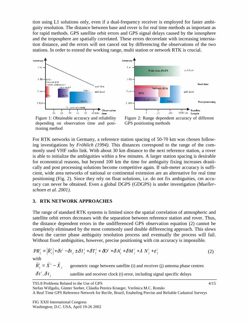
Rapid GPS methods have been developed to reduce the long observation times of one hourand more for static GPS surveys (Fig. 1). These methods can be divided into rapid static,semi kinematic (stop&go) and pure kinematic methods (Seeber 1993). In the static mode,only the coordinates of a stationary antenna are recorded, in the kinematic mode the entiretrajectory is determined. For all three methods, the solutions are usually derived in post pro-cessing. The stop&go technique is close to the requirements for real time positioning. Ifambiguities are resolved, the GPS signals must be locked continuously while the rovers movefrom one point to the next. As long as the ambiguities are kept fixed, a single measurement(epoch) is in principle sufficient for a precise determination of coordinate differences be-tween two GPS receivers
rovRSRSrov XXX −∆+= with [ ]TrovRS ZYXX ∆∆∆=∆ − ,, . (1)
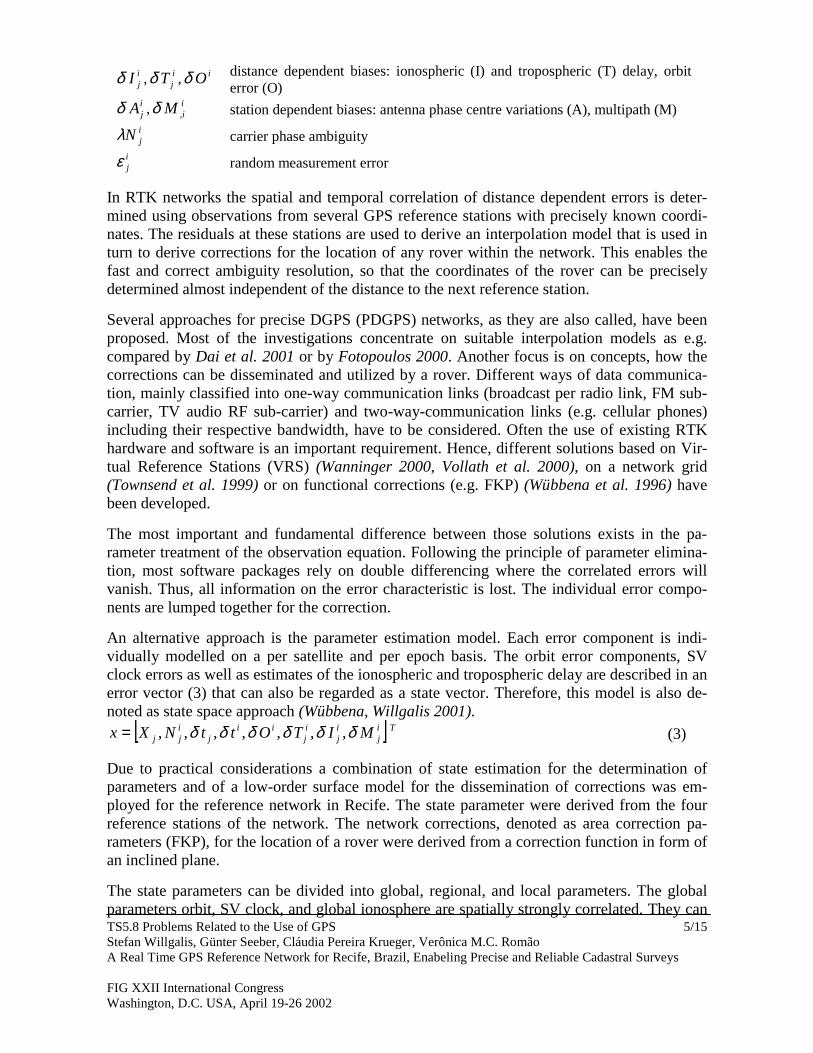
RTK systems consisting of two GPS receivers, an UHF data link for real time corrections,and a processing software with OTW (on the way) ambiguity resolution algorithm overcomesthe drawbacks of the stop&go method. Cycle slips due to signal obstructions are detectedimmediately and ambiguities are quickly resolved again. But RTK systems also have a majordisadvantage, the baseline length is limited to between 5 and 10 km (Fig. 2). At first, this isdue to the limited range of the UHF radio link and secondly, RTK systems estimate the posi-
TS5.8 Problems Related to the Use of GPSStefan Willgalis, Günter Seeber, Cláudia Pereira Krueger, Verônica M.C. RomãoA Real Time GPS Reference Network for Recife, Brazil, Enabeling Precise and Reliable Cadastral Surveys
FIG XXII International CongressWashington, D.C. USA, April 19-26 2002
4/15
tion using L1 solutions only, even if a dual-frequency receiver is employed for faster ambi-guity resolution. The distance between base and rover is for real time methods as important asfor rapid methods. GPS satellite orbit errors and GPS signal delays caused by the ionosphereand the troposphere are spatially correlated. These errors decorrelate with increasing intersta-tion distance, and the errors will not cancel out by differencing the observations of the twostations. In order to extend the working range, multi station or network RTK is crucial.
For RTK networks in Germany, a reference station spacing of 50-70 km was chosen follow-ing investigations by Fröhlich (1994). This distances correspond to the range of the com-monly used VHF radio link. With about 30 km distance to the next reference station, a roveris able to initialize the ambiguities within a few minutes. A larger station spacing is desirablefor economical reasons, but beyond 100 km the time for ambiguity fixing increases drasti-cally and post processing solutions become competitive again. If sub-meter accuracy is suffi-cient, wide area networks of national or continental extension are an alternative for real timepositioning (Fig. 2). Since they rely on float solutions, i.e. do not fix ambiguities, cm accu-racy can never be obtained. Even a global DGPS (GDGPS) is under investigation (Mueller-schoen et al. 2001).
3. RTK NETWORK APPROACHES
The range of standard RTK systems is limited since the spatial correlation of atmospheric andsatellite orbit errors decreases with the separation between reference station and rover. Thus,the distance dependent errors in the undifferenced GPS observation equation (2) cannot becompletely eliminated by the most commonly used double differencing approach. This slowsdown the carrier phase ambiguity resolution process and eventually the process will fail.Without fixed ambiguities, however, precise positioning with cm accuracy is impossible.
ij
ij
ij
ij
iij
ijj
iij
ij NMAOTIttRPR ελδδδδδδδ ++++++±−+=
�
(2)with
jii
j XXR���
−= geometric range between satellite (i) and receiver (j) antenna phase centresitδ , jtδ satellite and receiver clock (t) error, including signal specific delays
Figure 1: Obtainable accuracy and reliabilitydepending on observation time and posi-tioning method
Figure 2: Range dependent accuracy of differentGPS positioning methods
TS5.8 Problems Related to the Use of GPSStefan Willgalis, Günter Seeber, Cláudia Pereira Krueger, Verônica M.C. RomãoA Real Time GPS Reference Network for Recife, Brazil, Enabeling Precise and Reliable Cadastral Surveys
FIG XXII International CongressWashington, D.C. USA, April 19-26 2002
5/15
ijIδ , i
jTδ , iOδ distance dependent biases: ionospheric (I) and tropospheric (T) delay, orbiterror (O)
ijAδ , i
iM ,δ station dependent biases: antenna phase centre variations (A), multipath (M)ijNλ carrier phase ambiguity
ijε random measurement error
In RTK networks the spatial and temporal correlation of distance dependent errors is deter-mined using observations from several GPS reference stations with precisely known coordi-nates. The residuals at these stations are used to derive an interpolation model that is used inturn to derive corrections for the location of any rover within the network. This enables thefast and correct ambiguity resolution, so that the coordinates of the rover can be preciselydetermined almost independent of the distance to the next reference station.
Several approaches for precise DGPS (PDGPS) networks, as they are also called, have beenproposed. Most of the investigations concentrate on suitable interpolation models as e.g.compared by Dai et al. 2001 or by Fotopoulos 2000. Another focus is on concepts, how thecorrections can be disseminated and utilized by a rover. Different ways of data communica-tion, mainly classified into one-way communication links (broadcast per radio link, FM sub-carrier, TV audio RF sub-carrier) and two-way-communication links (e.g. cellular phones)including their respective bandwidth, have to be considered. Often the use of existing RTKhardware and software is an important requirement. Hence, different solutions based on Vir-tual Reference Stations (VRS) (Wanninger 2000, Vollath et al. 2000), on a network grid(Townsend et al. 1999) or on functional corrections (e.g. FKP) (Wübbena et al. 1996) havebeen developed.
The most important and fundamental difference between those solutions exists in the pa-rameter treatment of the observation equation. Following the principle of parameter elimina-tion, most software packages rely on double differencing where the correlated errors willvanish. Thus, all information on the error characteristic is lost. The individual error compo-nents are lumped together for the correction.
An alternative approach is the parameter estimation model. Each error component is indi-vidually modelled on a per satellite and per epoch basis. The orbit error components, SVclock errors as well as estimates of the ionospheric and tropospheric delay are described in anerror vector (3) that can also be regarded as a state vector. Therefore, this model is also de-noted as state space approach (Wübbena, Willgalis 2001).
[ ] Tij
ij
ij
iij
ijj MITOttNXx δδδδδδ ,,,,,,,= (3)
Due to practical considerations a combination of state estimation for the determination ofparameters and of a low-order surface model for the dissemination of corrections was em-ployed for the reference network in Recife. The state parameter were derived from the fourreference stations of the network. The network corrections, denoted as area correction pa-rameters (FKP), for the location of a rover were derived from a correction function in form ofan inclined plane.
The state parameters can be divided into global, regional, and local parameters. The globalparameters orbit, SV clock, and global ionosphere are spatially strongly correlated. They can
TS5.8 Problems Related to the Use of GPSStefan Willgalis, Günter Seeber, Cláudia Pereira Krueger, Verônica M.C. RomãoA Real Time GPS Reference Network for Recife, Brazil, Enabeling Precise and Reliable Cadastral Surveys
FIG XXII International CongressWashington, D.C. USA, April 19-26 2002
6/15
be determined at best in a larger network of national or continental extension. Small and me-dium scale variations of the ionosphere and troposphere make up the regional parameters.They show only little spatial correlation and need therefore a dense network of reference sta-tions for their estimation. Local parameters like multipath are solely station dependent andspatially uncorrelated with multipath at other sites. Attempts are made to average out multi-path by filtering in the state space model. Another promising approach is the multipath cali-bration of each reference station site (Böder et al. 2001), taking advantage of the fixed an-tenna-reflector geometry at each site and the repetitive satellite constellation. The use of ab-solute calibrated antennas (Menge 1998) is definitely required if different antenna types areemployed at reference and rover stations.
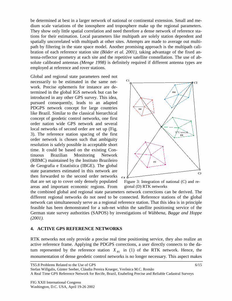
Global and regional state parameters need notnecessarily to be estimated in the same net-work. Precise ephemeris for instance are de-termined in the global IGS network but can beintroduced in any other GPS survey. This idea,pursued consequently, leads to an adaptedPDGPS network concept for large countrieslike Brazil. Similar to the classical hierarchicalconcept of geodetic control networks, one firstorder nation wide GPS network and severallocal networks of second order are set up (Fig.3). The reference station spacing of the firstorder network is chosen such that ambiguityresolution is safely possible in acceptable shorttime. It could be based on the existing Con-tinuous Brazilian Monitoring Network(RBMC) maintained by the Instituto Brazileirode Geografia e Estatística (IBGE). The globalstate parameters estimated in this network arethen forwarded to the second order networksthat are set up to cover only densely populatedareas and important economic regions. Fromthe combined global and regional state parameters network corrections can be derived. Thedifferent regional networks do not need to be connected. Reference stations of the globalnetwork can simultaneously serve as a regional reference station. That this idea is in principlefeasible has been demonstrated for a sub-net within the satellite positioning service of theGerman state survey authorities (SAPOS) by investigations of Wübbena, Bagge and Hoppe(2001).
4. ACTIVE GPS REFERENCE NETWORKS
RTK networks not only provide a precise real time positioning service, they also realize anactive reference frame. Applying the PDGPS corrections, a user directly connects to the da-tum represented by the reference station RSX in (1) of the RTK network. Hence, themonumentation of dense geodetic control networks is no longer necessary. This aspect makes
Figure 3: Integration of national (C) and re-gional (D) RTK networks
TS5.8 Problems Related to the Use of GPSStefan Willgalis, Günter Seeber, Cláudia Pereira Krueger, Verônica M.C. RomãoA Real Time GPS Reference Network for Recife, Brazil, Enabeling Precise and Reliable Cadastral Surveys
FIG XXII International CongressWashington, D.C. USA, April 19-26 2002
7/15
RTK networks especially economical. Augath (1994) showed for the State Survey Authorityof Lower Saxony, Germany, that the maintenance of all monumented control points andsurvey markers needs the highest expenditure of the Survey Authorities budget. Putting asidethe legal aspects of boundary markers, such monumentations are not required if cadastralsurveys are directly linked to the RTK network.
For large countries like Brazil this means, the efforts for establishing and maintaining densecontrol networks can be replaced by the operation of active reference networks. The trans-formation of the various existing networks into the new homogeneous and unified GPS basedframe will remain the largest challenge, although suitable transformation strategies havealready been developed. Beyond the surveying experts, the active reference frame will beespecially valuable for all other GPS users in various applications (e.g. GIS, rural landmanagement, agriculture, civil engineering, town planning, energy supply, geophysicalexploration, hydrographic surveys and marine applications). For those users, mostly notfamiliar with different datums and frames, a single standardized reference frame will be ofhighest value.
5. SURVEYING APPLICATIONS OF RTK NETWORKS
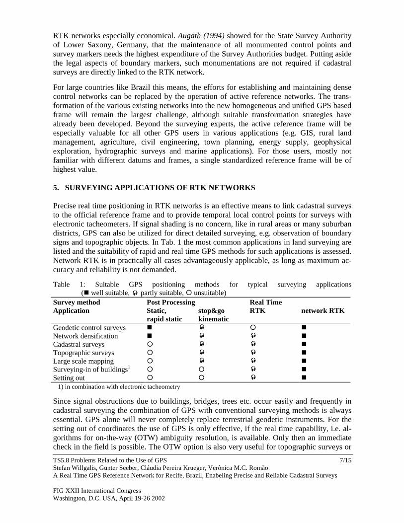
Precise real time positioning in RTK networks is an effective means to link cadastral surveysto the official reference frame and to provide temporal local control points for surveys withelectronic tacheometers. If signal shading is no concern, like in rural areas or many suburbandistricts, GPS can also be utilized for direct detailed surveying, e.g. observation of boundarysigns and topographic objects. In Tab. 1 the most common applications in land surveying arelisted and the suitability of rapid and real time GPS methods for such applications is assessed.Network RTK is in practically all cases advantageously applicable, as long as maximum ac-curacy and reliability is not demanded.
Table 1: Suitable GPS positioning methods for typical surveying applications(� well suitable, � partly suitable, � unsuitable)
Survey method Post Processing Real TimeApplication Static,
rapid staticstop&gokinematic
RTK network RTK
Geodetic control surveys � � � �
Network densification � � � �
Cadastral surveys � � � �
Topographic surveys � � � �
Large scale mapping � � � �
Surveying-in of buildings1� � � �
Setting out � � � �
1) in combination with electronic tacheometry
Since signal obstructions due to buildings, bridges, trees etc. occur easily and frequently incadastral surveying the combination of GPS with conventional surveying methods is alwaysessential. GPS alone will never completely replace terrestrial geodetic instruments. For thesetting out of coordinates the use of GPS is only effective, if the real time capability, i.e. al-gorithms for on-the-way (OTW) ambiguity resolution, is available. Only then an immediatecheck in the field is possible. The OTW option is also very useful for topographic surveys or
TS5.8 Problems Related to the Use of GPSStefan Willgalis, Günter Seeber, Cláudia Pereira Krueger, Verônica M.C. RomãoA Real Time GPS Reference Network for Recife, Brazil, Enabeling Precise and Reliable Cadastral Surveys
FIG XXII International CongressWashington, D.C. USA, April 19-26 2002
8/15
GIS mapping, if an automatic data flow to a field computer is established. By visualising thesurveyed objects over the existing data base, missing areas and objects are easily identified.Gross errors like mismatched points are also quickly to recognize.
Real time methods are also suitable for height transfers with subdecimeter accuracy. The useof identical antenna types on the reference and rover station or calibrated antennas is a pre-requisite. The antenna set-up including the determination of the antenna height needs par-ticular care. For higher accuracy requirements longer static GPS observations and extensivepost processing is necessary. With GPS, only geometrically defined ellipsoidal heights andheight differences can be determined. In order to derive heights related to the gravity field, aprecise geoid model is required.
6. GPS REFERENCE NETWORK SET-UP
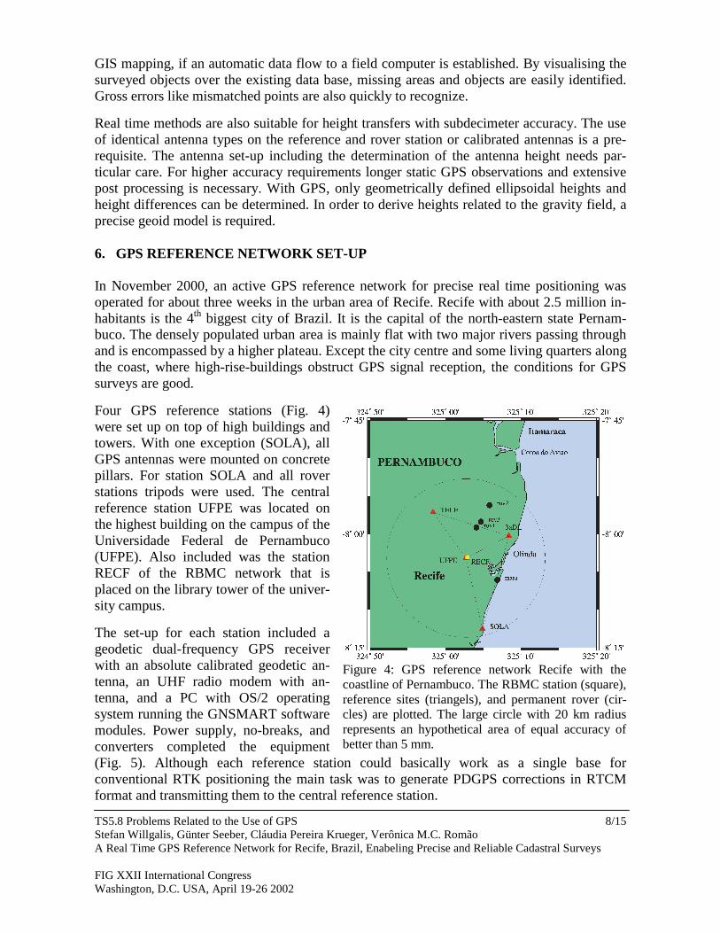
In November 2000, an active GPS reference network for precise real time positioning wasoperated for about three weeks in the urban area of Recife. Recife with about 2.5 million in-habitants is the 4th biggest city of Brazil. It is the capital of the north-eastern state Pernam-buco. The densely populated urban area is mainly flat with two major rivers passing throughand is encompassed by a higher plateau. Except the city centre and some living quarters alongthe coast, where high-rise-buildings obstruct GPS signal reception, the conditions for GPSsurveys are good.
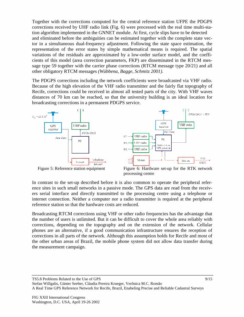
Four GPS reference stations (Fig. 4)were set up on top of high buildings andtowers. With one exception (SOLA), allGPS antennas were mounted on concretepillars. For station SOLA and all roverstations tripods were used. The centralreference station UFPE was located onthe highest building on the campus of theUniversidade Federal de Pernambuco(UFPE). Also included was the stationRECF of the RBMC network that isplaced on the library tower of the univer-sity campus.
The set-up for each station included ageodetic dual-frequency GPS receiverwith an absolute calibrated geodetic an-tenna, an UHF radio modem with an-tenna, and a PC with OS/2 operatingsystem running the GNSMART softwaremodules. Power supply, no-breaks, andconverters completed the equipment(Fig. 5). Although each reference station could basically work as a single base forconventional RTK positioning the main task was to generate PDGPS corrections in RTCMformat and transmitting them to the central reference station.
Figure 4: GPS reference network Recife with thecoastline of Pernambuco. The RBMC station (square),reference sites (triangels), and permanent rover (cir-cles) are plotted. The large circle with 20 km radiusrepresents an hypothetical area of equal accuracy ofbetter than 5 mm.
TS5.8 Problems Related to the Use of GPSStefan Willgalis, Günter Seeber, Cláudia Pereira Krueger, Verônica M.C. RomãoA Real Time GPS Reference Network for Recife, Brazil, Enabeling Precise and Reliable Cadastral Surveys
FIG XXII International CongressWashington, D.C. USA, April 19-26 2002
9/15
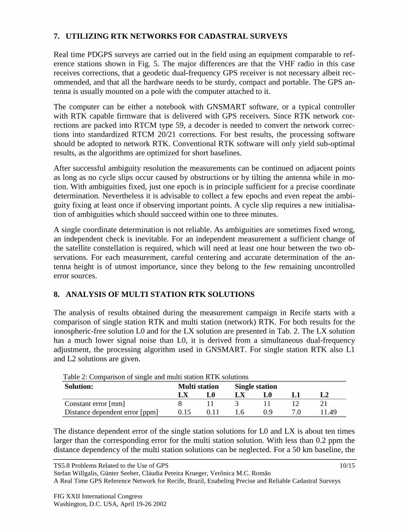
Together with the corrections computed for the central reference station UFPE the PDGPScorrections received by UHF radio link (Fig. 6) were processed with the real time multi-sta-tion algorithm implemented in the GNNET module. At first, cycle slips have to be detectedand eliminated before the ambiguities can be estimated together with the complete state vec-tor in a simultaneous dual-frequency adjustment. Following the state space estimation, therepresentation of the error states by simple mathematical means is required. The spatialvariations of the residuals are approximated by a low-order surface model, and the coeffi-cients of this model (area correction parameters, FKP) are disseminated in the RTCM mes-sage type 59 together with the carrier phase corrections (RTCM message type 20/21) and allother obligatory RTCM messages (Wübbena, Bagge, Schmitz 2001).
The PDGPS corrections including the network coefficients were broadcasted via VHF radio.Because of the high elevation of the VHF radio transmitter and the fairly flat topography ofRecife, corrections could be received in almost all tested parts of the city. With VHF wavesdistances of 70 km can be reached, so that the university building is an ideal location forbroadcasting corrections in a permanent PDGPS service.
Figure 5: Reference station equipment Figure 6: Hardware set-up for the RTK networkprocessing centre
In contrast to the set-up described before it is also common to operate the peripheral refer-ence sites in such small networks in a passive mode. The GPS data are read from the receiv-ers serial interface and directly transmitted to the processing centre using a telephone orinternet connection. Neither a computer nor a radio transmitter is required at the peripheralreference station so that the hardware costs are reduced.
Broadcasting RTCM corrections using VHF or other radio frequencies has the advantage thatthe number of users is unlimited. But it can be difficult to cover the whole area reliably withcorrections, depending on the topography and on the extension of the network. Cellularphones are an alternative, if a good communication infrastructure ensures the reception ofcorrections in all parts of the network. Although this assumption holds for Recife and most ofthe other urban areas of Brazil, the mobile phone system did not allow data transfer duringthe measurement campaign.
TS5.8 Problems Related to the Use of GPSStefan Willgalis, Günter Seeber, Cláudia Pereira Krueger, Verônica M.C. RomãoA Real Time GPS Reference Network for Recife, Brazil, Enabeling Precise and Reliable Cadastral Surveys
FIG XXII International CongressWashington, D.C. USA, April 19-26 2002
10/15
7. UTILIZING RTK NETWORKS FOR CADASTRAL SURVEYS
Real time PDGPS surveys are carried out in the field using an equipment comparable to ref-erence stations shown in Fig. 5. The major differences are that the VHF radio in this casereceives corrections, that a geodetic dual-frequency GPS receiver is not necessary albeit rec-ommended, and that all the hardware needs to be sturdy, compact and portable. The GPS an-tenna is usually mounted on a pole with the computer attached to it.
The computer can be either a notebook with GNSMART software, or a typical controllerwith RTK capable firmware that is delivered with GPS receivers. Since RTK network cor-rections are packed into RTCM type 59, a decoder is needed to convert the network correc-tions into standardized RTCM 20/21 corrections. For best results, the processing softwareshould be adopted to network RTK. Conventional RTK software will only yield sub-optimalresults, as the algorithms are optimized for short baselines.
After successful ambiguity resolution the measurements can be continued on adjacent pointsas long as no cycle slips occur caused by obstructions or by tilting the antenna while in mo-tion. With ambiguities fixed, just one epoch is in principle sufficient for a precise coordinatedetermination. Nevertheless it is advisable to collect a few epochs and even repeat the ambi-guity fixing at least once if observing important points. A cycle slip requires a new initialisa-tion of ambiguities which should succeed within one to three minutes.
A single coordinate determination is not reliable. As ambiguities are sometimes fixed wrong,an independent check is inevitable. For an independent measurement a sufficient change ofthe satellite constellation is required, which will need at least one hour between the two ob-servations. For each measurement, careful centering and accurate determination of the an-tenna height is of utmost importance, since they belong to the few remaining uncontrollederror sources.
8. ANALYSIS OF MULTI STATION RTK SOLUTIONS
The analysis of results obtained during the measurement campaign in Recife starts with acomparison of single station RTK and multi station (network) RTK. For both results for theionospheric-free solution L0 and for the LX solution are presented in Tab. 2. The LX solutionhas a much lower signal noise than L0, it is derived from a simultaneous dual-frequencyadjustment, the processing algorithm used in GNSMART. For single station RTK also L1and L2 solutions are given.
Table 2: Comparison of single and multi station RTK solutionsSolution: Multi station Single station
LX L0 LX L0 L1 L2Constant error [mm] 8 11 3 11 12 21Distance dependent error [ppm] 0.15 0.11 1.6 0.9 7.0 11.49
The distance dependent error of the single station solutions for L0 and LX is about ten timeslarger than the corresponding error for the multi station solution. With less than 0.2 ppm thedistance dependency of the multi station solutions can be neglected. For a 50 km baseline, the
TS5.8 Problems Related to the Use of GPSStefan Willgalis, Günter Seeber, Cláudia Pereira Krueger, Verônica M.C. RomãoA Real Time GPS Reference Network for Recife, Brazil, Enabeling Precise and Reliable Cadastral Surveys
FIG XXII International CongressWashington, D.C. USA, April 19-26 2002
11/15
distance dependent error would not exceed 1 cm which is well within the specifications forcadastral surveys. Single stations solutions on the contrary will exceed such specificationsbeyond a baseline length of 10 km. Even worse is the result for single frequency receivercommonly used in RTK systems. For the L1 signal, a distance dependent error of 7 ppm wasestimated, mainly due to the strong ionosphere in Brazil. Assuming a threshold of 2 cm, suchsystems could only be used for baselines up to 3 km. It should be remarked that single stationRTK solution could hardly be achieved for baselines longer than 12 km. The times to fix am-biguities (TTFA) increased by 300 sec per 10 km distance, so that rapid static methods be-come competitive.
In Tab. 2, a constant error is listed besides the distance dependent error. This constant errorincludes mainly signal noise and station dependent error components like e.g. multipath. ForL0, a constant error of 11 mm corresponds to the noise of the iono-free linear combination.For LX, a constant error of 2-4 mm can be expected. The much higher value for the multistation solution of LX is due to unmodelled effects in the RTK network.
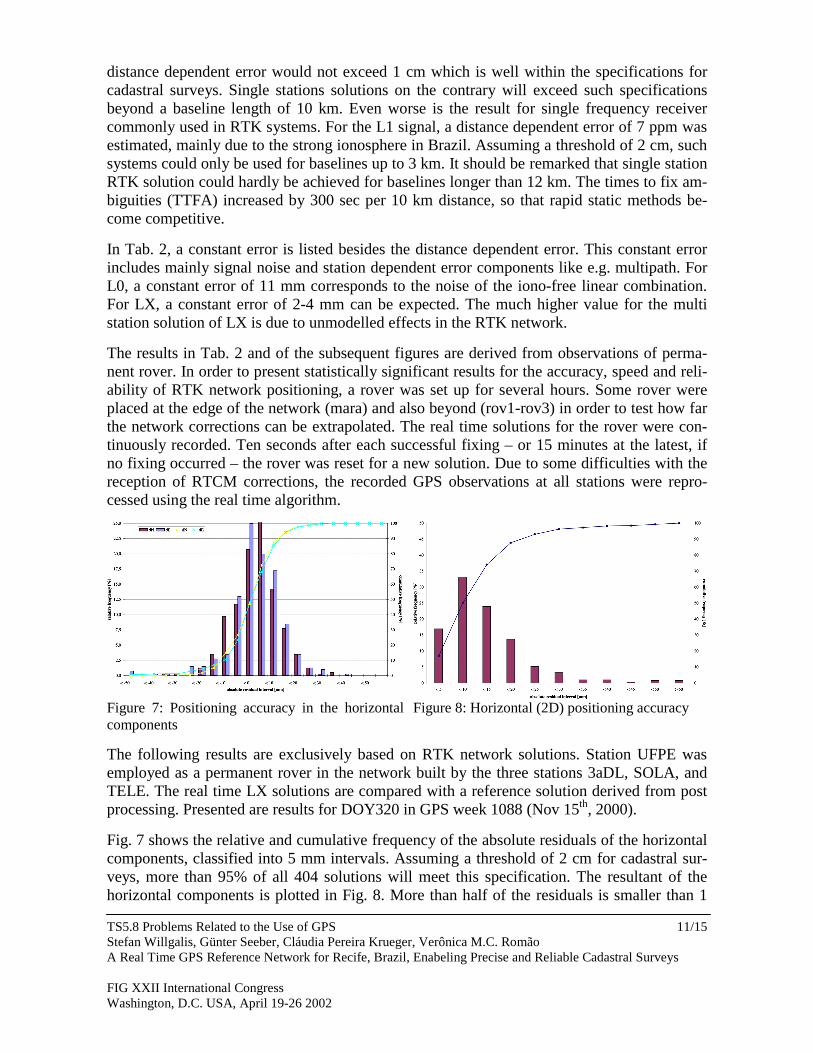
The results in Tab. 2 and of the subsequent figures are derived from observations of perma-nent rover. In order to present statistically significant results for the accuracy, speed and reli-ability of RTK network positioning, a rover was set up for several hours. Some rover wereplaced at the edge of the network (mara) and also beyond (rov1-rov3) in order to test how farthe network corrections can be extrapolated. The real time solutions for the rover were con-tinuously recorded. Ten seconds after each successful fixing – or 15 minutes at the latest, ifno fixing occurred – the rover was reset for a new solution. Due to some difficulties with thereception of RTCM corrections, the recorded GPS observations at all stations were repro-cessed using the real time algorithm.
Figure 7: Positioning accuracy in the horizontalcomponents
Figure 8: Horizontal (2D) positioning accuracy
The following results are exclusively based on RTK network solutions. Station UFPE wasemployed as a permanent rover in the network built by the three stations 3aDL, SOLA, andTELE. The real time LX solutions are compared with a reference solution derived from postprocessing. Presented are results for DOY320 in GPS week 1088 (Nov 15th, 2000).
Fig. 7 shows the relative and cumulative frequency of the absolute residuals of the horizontalcomponents, classified into 5 mm intervals. Assuming a threshold of 2 cm for cadastral sur-veys, more than 95% of all 404 solutions will meet this specification. The resultant of thehorizontal components is plotted in Fig. 8. More than half of the residuals is smaller than 1
TS5.8 Problems Related to the Use of GPSStefan Willgalis, Günter Seeber, Cláudia Pereira Krueger, Verônica M.C. RomãoA Real Time GPS Reference Network for Recife, Brazil, Enabeling Precise and Reliable Cadastral Surveys
FIG XXII International CongressWashington, D.C. USA, April 19-26 2002
12/15
cm and 90% is within the threshold of 2 cm. These results prove that even under the unfavor-able ionospheric conditions in Brazil multi station RTK is a powerful GPS positioningmethod for cadastral surveys.
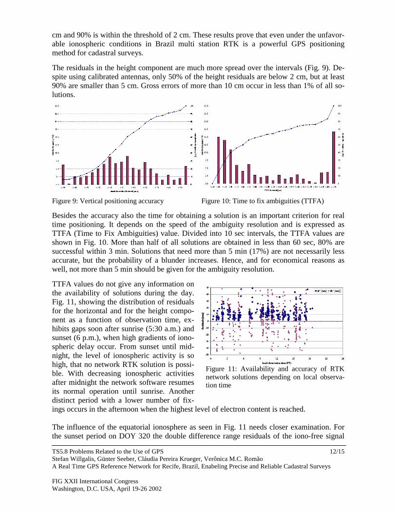
The residuals in the height component are much more spread over the intervals (Fig. 9). De-spite using calibrated antennas, only 50% of the height residuals are below 2 cm, but at least90% are smaller than 5 cm. Gross errors of more than 10 cm occur in less than 1% of all so-lutions.
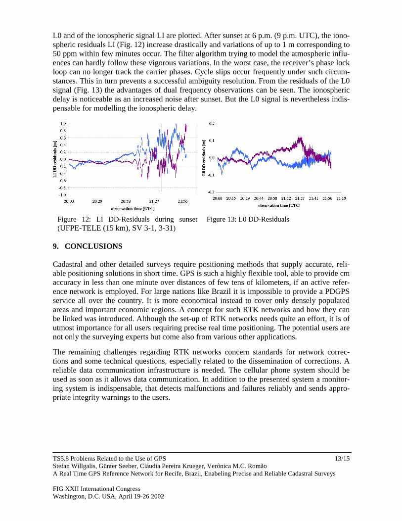
Figure 9: Vertical positioning accuracy Figure 10: Time to fix ambiguities (TTFA)
Besides the accuracy also the time for obtaining a solution is an important criterion for realtime positioning. It depends on the speed of the ambiguity resolution and is expressed asTTFA (Time to Fix Ambiguities) value. Divided into 10 sec intervals, the TTFA values areshown in Fig. 10. More than half of all solutions are obtained in less than 60 sec, 80% aresuccessful within 3 min. Solutions that need more than 5 min (17%) are not necessarily lessaccurate, but the probability of a blunder increases. Hence, and for economical reasons aswell, not more than 5 min should be given for the ambiguity resolution.
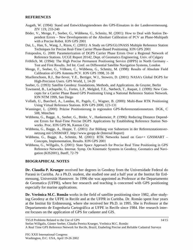
TTFA values do not give any information onthe availability of solutions during the day.Fig. 11, showing the distribution of residualsfor the horizontal and for the height compo-nent as a function of observation time, ex-hibits gaps soon after sunrise (5:30 a.m.) andsunset (6 p.m.), when high gradients of iono-spheric delay occur. From sunset until mid-night, the level of ionospheric activity is sohigh, that no network RTK solution is possi-ble. With decreasing ionospheric activitiesafter midnight the network software resumesits normal operation until sunrise. Anotherdistinct period with a lower number of fix-ings occurs in the afternoon when the highest level of electron content is reached.
The influence of the equatorial ionosphere as seen in Fig. 11 needs closer examination. Forthe sunset period on DOY 320 the double difference range residuals of the iono-free signal
Figure 11: Availability and accuracy of RTKnetwork solutions depending on local observa-tion time
TS5.8 Problems Related to the Use of GPSStefan Willgalis, Günter Seeber, Cláudia Pereira Krueger, Verônica M.C. RomãoA Real Time GPS Reference Network for Recife, Brazil, Enabeling Precise and Reliable Cadastral Surveys
FIG XXII International CongressWashington, D.C. USA, April 19-26 2002
13/15
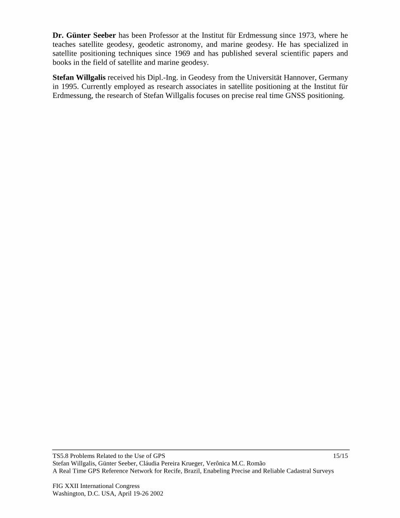
L0 and of the ionospheric signal LI are plotted. After sunset at 6 p.m. (9 p.m. UTC), the iono-spheric residuals LI (Fig. 12) increase drastically and variations of up to 1 m corresponding to50 ppm within few minutes occur. The filter algorithm trying to model the atmospheric influ-ences can hardly follow these vigorous variations. In the worst case, the receiver’s phase lockloop can no longer track the carrier phases. Cycle slips occur frequently under such circum-stances. This in turn prevents a successful ambiguity resolution. From the residuals of the L0signal (Fig. 13) the advantages of dual frequency observations can be seen. The ionosphericdelay is noticeable as an increased noise after sunset. But the L0 signal is nevertheless indis-pensable for modelling the ionospheric delay.
Figure 12: LI DD-Residuals during sunset(UFPE-TELE (15 km), SV 3-1, 3-31)
Figure 13: L0 DD-Residuals
9. CONCLUSIONS
Cadastral and other detailed surveys require positioning methods that supply accurate, reli-able positioning solutions in short time. GPS is such a highly flexible tool, able to provide cmaccuracy in less than one minute over distances of few tens of kilometers, if an active refer-ence network is employed. For large nations like Brazil it is impossible to provide a PDGPSservice all over the country. It is more economical instead to cover only densely populatedareas and important economic regions. A concept for such RTK networks and how they canbe linked was introduced. Although the set-up of RTK networks needs quite an effort, it is ofutmost importance for all users requiring precise real time positioning. The potential users arenot only the surveying experts but come also from various other applications.
The remaining challenges regarding RTK networks concern standards for network correc-tions and some technical questions, especially related to the dissemination of corrections. Areliable data communication infrastructure is needed. The cellular phone system should beused as soon as it allows data communication. In addition to the presented system a monitor-ing system is indispensable, that detects malfunctions and failures reliably and sends appro-priate integrity warnings to the users.
TS5.8 Problems Related to the Use of GPSStefan Willgalis, Günter Seeber, Cláudia Pereira Krueger, Verônica M.C. RomãoA Real Time GPS Reference Network for Recife, Brazil, Enabeling Precise and Reliable Cadastral Surveys
FIG XXII International CongressWashington, D.C. USA, April 19-26 2002
14/15
REFERENCES
Augath, W. (1994): Stand und Entwicklungstendenen des GPS-Einsatzes in der Landesvermessung.ZfV 119, 233-240
Böder, V., Menge, F., Seeber, G., Wübbena, G., Schmitz, M. (2001): How to Deal with Station De-pendent Errors – New Developmemts of the Absoluet Calibration of PCV an Phase-Multipathwith a Precise Robot. ION GPS 2001
Dai, L., Han, S., Wang, J., Rizos, C. (2001): A Study on GPS/GLONASS Multiple Reference StationTechniques for Precise Real-Time Carrier Phase-Based Positioning. ION GPS 2001
Fotopoulos, G. 2000: Parameterization of DGPS Carrier Phase Errors Over a Regional Network ofReference Stations. UCGE Report 20142, Dept. of Geomatics Engineering, Univ. of Calgary
Fröhlich, M. (1994): The High Precise Permanent Positioning Service (HPPS) in North Germany -Test and First Results. 3rd Int. Conf. on Differential Satellite Navigation Systems, London
Menge, F., Seeber, G., Völksen, C., Wübbena, G., Schmitz, M. (1998): Results of Absolute FieldCalibration of GPS Antenna PCV. ION GPS 1998, 31-38
Muellerschoen, R.J., Bar-Sever, Y.E., Bertiger, W.I., Stowers, D. (2001): NASA's Global DGPS forHigh-Precision Users. GPS World, 1, 14-20
Seeber, G. (1993): Satellite Geodesy: foundations, Methods, and Applications. de Gruyter, BerlinTownsend, B., Lachapelle, G., Fortes, L.P., Melgård, T.E., Nørbech, T., Raquet, J. (1999): New Con-
cepts for a Carrier Phase Based GPS Positioning Using a National Reference Station Network.ION NTM 1999, San Diego
Vollath, U., Buecherl, A., Landau, H., Pagels, C., Wagner, B. (2000): Multi-Base RTK PositioningUsing Virtual Reference Stations. ION GPS 2000, 123-131
Wanninger, L. (2000): Präzise Positionierung in regionalen GPS-Referenzstationsnetzen. DGK, C508, München
Wübbena, G., Bagge, A., Seeber, G., Böder, V., Hankemeier, P. (1996): Reducing Distance Depend-ent Errors for Real-Time Precise DGPS Applications by Establishing Reference Station Net-works. Proc. ION GPS 96, Kansas City
Wübbena, G., Bagge, A., Hoppe, T. (2001): Zur Bildung von Subnetzen in der Referenzstationsver-netzung mit GNSMART. http://www.geopp.de (Internal Report)
Wübbena, G., Bagge, A., Schmitz, M. (2001): RTK Networks based on Geo++ GNSMART –Concepts, Implementation, Results. ION GPS 2001
Wübbena, G., Willgalis, S. (2001): State Space Approach for Precise Real Time Positioning in GPSReference Networks. Internat. Symp. On Kinematic Systems in Geodesy, Geomatics and Navi-gation (KIS2001), Banff, 72-79
BIOGRAPHICAL NOTES
Dr. Claudia P. Krueger received her degrees in Geodesy from the Universidade Federal doParaná in Curitiba. As a Ph.D. student, she studied one and a half year at the Institut für Erd-messung, Universität Hannover. In 1996 she was appointed as Professor at the Departamentode Geomatica (UFPR), where her research and teaching is concerned with GPS positioningespecially for marine applications.
Dr. Verônica M.C. Romão works in the field of satellite positioning since 1982, after study-ing Geodesy at the UFPE in Recife and at the UFPR in Curitiba. Dr. Romão spent four yearsat the Institut für Erdmessung, where she received her Ph.D. in 1995. She is Professor at theDepartamento de Engenharia Cartográfica at UFPE in Recife since 1984. Her research inter-est focuses on the application of GPS for cadaster and GIS.
TS5.8 Problems Related to the Use of GPSStefan Willgalis, Günter Seeber, Cláudia Pereira Krueger, Verônica M.C. RomãoA Real Time GPS Reference Network for Recife, Brazil, Enabeling Precise and Reliable Cadastral Surveys
FIG XXII International CongressWashington, D.C. USA, April 19-26 2002
15/15
Dr. Günter Seeber has been Professor at the Institut für Erdmessung since 1973, where heteaches satellite geodesy, geodetic astronomy, and marine geodesy. He has specialized insatellite positioning techniques since 1969 and has published several scientific papers andbooks in the field of satellite and marine geodesy.
Stefan Willgalis received his Dipl.-Ing. in Geodesy from the Universität Hannover, Germanyin 1995. Currently employed as research associates in satellite positioning at the Institut fürErdmessung, the research of Stefan Willgalis focuses on precise real time GNSS positioning.