Embed Size (px)
Citation preview
Journalof Aquatic Ecosystem Health 5: 41-54, 1996. 41 © 1996 Kluwer Academic Publishers. Printed in the Netherlands.
A qualitative procedure for the assessment of the habitat integrity status of the Luvuvhu River (Limpopo system, South Africa)
C. J. K l e y n h a n s Institute for Water Quality Studies, Department of Water Affairs and Forestry, Private Bag X 313, Pretoria 0001, South Africa
Received 1 November 1994; accepted in revised form 15 September 1995
Keywords: biotic integrity, ecological integrity, instream, riparian
Abstract
The riparian zone and instream habitat integrity of the Luvuvhu River were assessed based on a qualitative rating of the impacts of major disturbance factors such as water abstraction, flow regulation, bed and channel modification, etc. A system was devised to assess the impact of these factors on the relative frequency and variability of habitats on a spatial and temporal scale gauged against habitat characteristics that could have been expected to occur under conditions not anthropogenically influenced. It was found that deterioration of habitat integrity can be ascribed primarily to water abstraction. This has resulted in the cessation of surface flow in a naturally perennial river during the dry season and during droughts with consequent tree deaths and a loss of fast flowing instream habitat types in the main stem of the river. The relatively small high rainfall area in the catchment, the highly variable rainfall pattern and the occurrence of sporadic severe droughts exacerbate the impact of water abstraction on the instream and riparian habitats with expected detrimental consequences for the associated biota. The effect of water abstraction is particularly severe in the lower part of the river which flows through the Kruger National Park as no perennial tributaries join the Luvuvhu River in this section. Other factors which affect the habitat integrity of the river are the removal of indigenous riparian vegetation in some river sections, encroachment by exotic vegetation, bank erosion and stream bed modification.
1. Introduction
The South African Department of Water Affairs and Forestry has adopted a water quality management approach based on fitness for use on a sustained basis of South African water resources with the desired quality of a water resource being determined by its present and/or future uses (Van der Merwe & Grobler, 1990). In addition, different user groups have been identified for management purposes, viz domestic, recreational, industrial, agricultural and natural envi- ronment (Department of Water Affairs and Forestry, 1993). However, the natural water environment is not regarded as a user in competition with the other users for water but rather as the source base from which water originates and as an entity with its own intrinsic environmental value.
Several, if not all, South African rivers are currently subjected to some major form of alteration and deterioration (Noble & Hemens, 1978; O'Keeffe, 1986). Generally these modifications can be equated to water quality problems and water abstraction. How- ever, other aspects such as catchment mismanagement and the physical alteration of aquatic habitats often play a major role. The scale of the problem is such that not all rivers can receive immediate attention and some prioritization process needs to be followed. Aspects that determine which rivers should be priorities for investigation, include inter alia, rivers important for human health and well-being and those which are comparatively undisturbed and have a high ecological importance or value.
The Luvuvhu River in the Northern Transvaal Province of South Africa represents a river signifi-
42
cant both from a human and ecological perspective. The portion of the river within the world renowned Kruger National Park is a wildemess area with out- standing natural features which results in this river being regarded as one of the most unique features of the Park (Department of Water Affairs and Forestry, 1990). Development in the catchment upstream from the Kruger National Park has, however, resulted in the ecological deterioration of the river. Consequently the maintenance of the ecological diversity of the river, and especially the Kruger National Park portion of the river is in jeopardy if the current problems persist or are increased in intensity (Department of Water Affairs and Forestry, 1990).
The objective of the current study was to assess the relative significance of various factors in the degrada- tion of the habitat integrity of the Luvuvhu River. This was achieved through the development of a descriptive, qualitative procedure. Detailed information to assess the biotic integrity (Karr & Dudley, 1981) in a more quantitative fashion, are not currently available.
was not included in this investigation due to its rela- tively undeveloped catchment and unregulated flow.
Based on a combination of catchment and river attributes as well as land use practices, a total of four reaches were identified for the Luvuvhu River (Figure 1).
'2.1. Reach 1
This 30-km-long reach starts downstream from the Albasini Dam and has an average slope of 3.3 m/km. Dykes traversing the river channel often create large bedrock areas with riffle and rapid habitat types sepa- rated by large pools.
2.2. Reach 2
The average slope (2.1 m/km) in this 70-km-long reach is less than in reach 1 with less riffle and bedrock areas. The river becomes wider here with large pools which are often fringed with reeds. In the middle and lower sections of this reach, sand banks occur regularly.
2. Study area 2.3. Reach 3
The study area included the mainstem of the Luvuvhu River from the Albasini Dam to the confluence with the Limpopo River at the South Africa/Zimbabwe/ Mozambique border (Figure 1). From its farthest upstream tributary to the Limpopo confluence, the mainstream of the Luvuvhu has a length of approx- imately 200 km. The river flows through a diverse range of landscapes with an ensuing high diversity of aquatic habitat types.
The catchment of the Luvuvhu River, excluding the Mutale tributary, covers an area of 3 470 km 2, and in 1985 had a human population of 270 500. Rainfall, which occurs in summer, ranges from 2068 mm/y in a relatively small area on the northwestern slopes of the Soutpansberg mountain range, to 440 mm/y near the confluence with the Limpopo River. This small, high altitude area (>1 200 m a.m.s.1.) contributes most of the Luvuvhu River's runoff through the contribu- tions of perennial tributaries such as the Mutshindudi, Dzindi and Latonyanda Rivers. These three rivers supply respectively 22.7, 10.9 and 11.9 percent of the total virgin runoff of the Luvuvhu (570 million m 3/y) at its confluence with the Limpopo River at 232 m a.m.s.1. Tributaries upstream and downstream from these rivers are seasonal, often with erratic flow (Department of Water Affairs and Forestry, 1990). The Mutale River
Upstream from the Mutale River confluence, the river flows through an extensive gorge area with a shorter gorge downstream from the Mutale confluence. In some parts the gorge area is less pronounced with the river having floodplain characteristics with allu- vial soils and sand occurring on the banks (e.g., immediately downstream from the confluence of the Luvuhu/Mutale Rivers). The gorge characteristics, however, are overwhelming with the river having an average slope of 3.6 m/km, extensive riffle and rapid type habitat, interspersed by large pools. Reeds are common with occasional reed islands also being present. This reach is 55 km long.
2.4. Reach 4
Having flowed through the gorge area of reach 3, the slope of the river decreases to 1.3 m/km as it enters a floodplain with deep alluvial soils. Occasionally riffles are present, especially in the upstream part near the gorge, but mostly the river is characterized by large pools, runs and glides with a sandy substrate. This reach is 15 km in length.
43
SOUTH AFRICA
ZIMBABWE
// /
/
.,/ . /
/ / "
/ •
REACH 4. ~\ MOZAMBIQUE \ \
l uvuvhu~.~
ALBASINI DAM REACH 1
F i g u r e 1 .
y It t
/ t
i t I
! I
I !
I /
/ /
I
KRUGER NATIONAL PARK
I I 5
kra
The Luvuvhu River and its main tributaries, indicating four river reaches.
N
3. Methodology
3.1. Ecological health, ecological integrity, habitat integrity and biotic integrity
Ecological health has been described as 'the condi- tion when a system's inherent potential is realized, its condition is stable, its capacity for self repair, when perturbed, is preserved, and minimal external support for management is needed' (Karr, 1993). In the same context, Regier (1993) describes ecological integrity as follows: 'a living system exhibits integrity if, when subjected to disturbance, it sustains an organizing, self correcting capability to recover toward an end-state that is normal or 'good' for that system. End states other than the pristine or naturally whole may be taken to be 'normal and good". In terms of these defini- tions and for the purposes of this study, the ecological integrity of a river is defined as its ability to support and maintain a balanced, integrated composition of physico- chemical and habitat characteristics, as well
as biotic components on a temporal and spatial scale that are comparable to the natural characteristics of ecosystems of the region. This definition is based on the concept of biological integrity that has been described as 'the ability to support and maintain a balanced, integrated, adaptive community of organ- isms having a species composition, diversity and functional organization comparable to that of natural habitat of the region' (Karr & Dudley, 1981). Habitat integrity in this sense then refers to the maintenance of a balanced, integrated composition of physico- chemical and habitat characteristics on a temporal and spatial scale that are comparable to the characteristics of natural habitats of the region.
Essentially, the habitat integrity status of a river will provide the template for a certain level of biotic integrity to be realized. In this sense the assessment of the habitat integrity of a river can be seen as a pre- cursor of the assessment of biotic integrity. It follows that in this context habitat integrity and biotic integrity together constitutes ecological integrity.
44
Compared to conservation status assessment (e.g., Kleynhans, 1994), habitat integrity assessment places less emphasis on the hypothetical natural state of the river as a baseline against which to measure deterio- ration or modification. More importance is placed on the functionality of the river to provide suitable living conditions for biota within the context of the tem- poral and spatial scale of the habitat compared with what is considered likely to have been the case in the absence of artificially created disturbance regimes. The self correcting capability of a river to recover to a not necessarily pristine end state, but a state that is 'normal' or 'good' for that system (Regier, 1993) is of central importance in the concept of habitat integrity.
The determination of the natural baseline condi- tions (including natural disturbance regimes) is based on recent and historical information on the specific river itself. This includes information on the hydrology, water quality, catchment characteristics, development, exotic or alien biota, etc.
3.2. River surveys and data analysis
The survey was based on two perspectives of the river, the riparian zone and instream channel. Habitat integrity assessments were made separately for both aspects but data for the riparian zone were primarily interpreted in terms of potential impact on the instream component.
Information on most of the modifications was primarily collected during a helicopter survey of the Luvuvhu River during May 1994 and was supple- mented with ground level observations made during October 1992 and April and October 1994. Prior to the aerial survey, the river was divided into numbered, 5 km segments on 1:250 000 topographical maps. The coordinates of these segments were stored on a global positioning system and were used by the navigator to indicate to the observers when the helicopter moved into a specific 5 km segment. Observations on aspects of the various river characteristics observable from the air were captured on audio cassette tape, while at the same time a continuous video recording was made of the total length of the river. The survey was conducted in a downstream direction at an altitude of approx- imately 50-100 m and the flight path followed the left bank of the river to enable the camera operator to record information on both river banks and the total width of the stream channel. Data from this aerial survey were supplemented with information from other readily available sources, e.g. hydrological data pro-
vided by the Department of Water Affairs and Forestry and the catchment study reports of the Department (Department of Water Affairs and Forestry, 1990).
Following the survey, all collected data were scru- tinized and information on the severity of the impacts of various modifications as well as general detail on river characteristics were recorded for each 5 km river segment (Table 1).
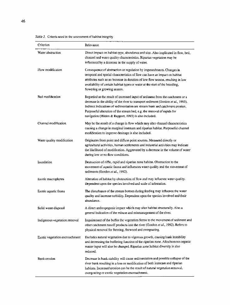
Criteria considered indicative of habitat integrity were selected on the basis that anthropogenic modifi- cation of their characteristics can generally be regarded as the primary causes of degradation of the habitat integrity of the river. The severity of certain modifica- tions will, therefore, have a detrimental impact on the habitat integrity of a river. This method is primarily habitat oriented with emphasis on a qualitative interpretation of the habitat quality, size, diversity, variability and predictability as influenced by vari- ous anthropogenic modifications. The contributions of seven river conservationists in the Transvaal were used to decide on the criteria to be used in habitat integrity assessment (Table 2).
The assessment of the severity of impact of modifications was based on six descriptive classes with ratings ranging from 0 (no impact), 1 to 5 (small impact), 6 to 10 (moderate impact), 11 to 15 (large impact), 16 to 20 (serious impact) and 21 to 25 (critical impact). A five point rating system was decided on to facilitate scoring flexibility within a class. This scoring system is comparable with the method used by Plafkin et al. (1989) for aquatic habitat quality assessment. Scoring was guided by a description of the severity of the impact of the modification for each score (Table 3).
The inputs of the previously mentioned river con- servationists were used to determine the relative weight of each criterion according to the method of Dean and Nishry (1965) (Table 4). This weighting method has been used in the evaluation of aquatic ecosystem habitat quality by the U.S. Army Corps of Engineers (U.S. Army Corps of Engineers, 1980).
Based on the weights of the criteria, the impact of a criterion was estimated as follows.
Rating for the criterion/maximum value (25) × the weight (percent), e.g., it is estimated that water abstraction (instream) has a moderate impact (Table 3) and a score of 10 is awarded. Water abstraction has a weight of 14 (Table 4) and the calculation proceeds as follows:
10/25 × 14 = 5.6.
45
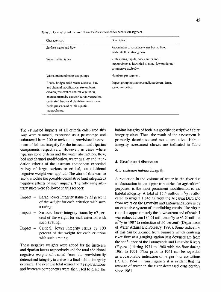
Table 1. General detail on river characteristics recorded for each 5 km segment
Characteristic Description
Surface water and flow
Water habitat types
Weirs, impoundments and pumps
Roads, bridges solid waste disposal, bed
and channel modification, stream bank
erosion, removal of natural vegetation,
encroachment by exotic riparian vegetation,
cultivated lands and plantations on stream
bank, presence of exotic aquatic
macrophytes.
Recorded as dry, surface water but no flow,
moderate flow, strong flow.
Riffles, runs, rapids, pools, weirs and
impoundments. Recorded as none, few moderate,
common or exclusive.
Numbers per segment.
Impact groupings: none, small, moderate, large,
serious or critical.
The estimated impacts of all criteria calculated this way were summed, expressed as a percentage and subtracted from 100 to arrive at a provisional assess- ment of habitat integrity for the instream and riparian components respectively. However, in cases where riparian zone criteria and the water abstraction, flow, bed and channel modification, water quality and inun- dation criteria of the instream component exceeded ratings of large, serious or critical, an additional negative weight was applied. The aim of this was to accommodate the possible cumulative (and integrated) negative effects of such impacts. The following arbi- trary rules were followed in this respect:
Impact = Large, lower integrity status by 33 percent of the weight for each criterion with such a rating.
Impact = Serious, lower integrity status by 67 per- cent of the weight for each criterion with such a rating.
Impact = Critical, lower integrity status by 100 percent of the weight for each criterion with such a rating.
These negative weights were added for the instream and riparian facets respectively and the total additional negative weight subtracted from the provisionally determined integrity to arrive at a final habitat integrity estimate. The eventual total scores for the riparian zone and instream components were then used to place the
habitat integrity of both in a specific descriptive habitat integrity class. Thus, the result of the assessment is primarily descriptive and not quantitative. Habitat integrity assessment classes are indicated in Table 5.
4. Results and discussion
4.1. lnstream habitat integrity
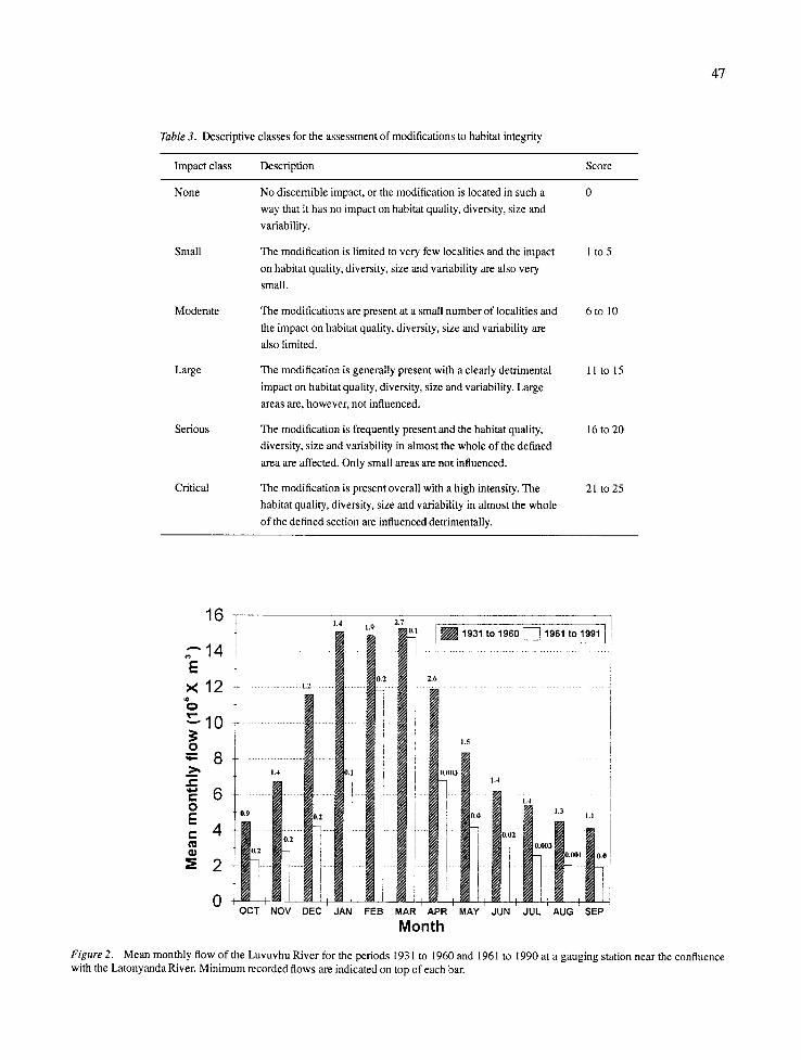
A reduction in the volume of water in the river due to abstraction in the upper tributaries for agricultural purposes, is the most prominent modification to the habitat integrity. A total of 15.4 million m3/y is allo- cated to irrigate 1 845 ha from the Albasini Dam and from weirs on the Luvuvhu and Latonyanda Rivers by an extensive system of interlinking canals. The virgin runoff at approximately the downstream end of reach 1 was reduced from 134.61 million m3/y to 86.20 million m3/y in 1987 (a reduction of 36 percent) (Department of Water Affairs and Forestry, 1990). Some indication of this can be gleaned from Figure 2 which contrasts river flow at a gauging station just downstream from the confluence of the Latonyanda and Luvuvhu Rivers (Figure 1) during 1931 to 1960 with the flow during 1961 to 1991. Flow prior to 1961 can be regarded as a reasonable indication of virgin flow conditions (Pullen, 1994). From Figure 2 it is evident that the amount of water in the river decreased considerably since 1961.
46
Table 2. Criteria used in the assessment of habitat integrity
Criterion Relevance
Water abstraction
Flow modification
Bed modification
Channel modification
Water quality modification
Inundation
Exotic macrophytes
Exotic aquatic fauna
Solid waste disposal
Indigenous vegetation removal
Exotic vegetation encroachment
Bank erosion
Direct impact on habitat type, abundance and size. Also implicated in flow, bed,
channel and water quality characteristics. Riparian vegetation may be
influenced by a decrease in the supply of water.
Consequence of abstraction or regulation by impoundments. Changes in
temporal and spatial characteristics of flow can have an impact on habitat
attributes such as an increase in duration of low flow season, resulting in low
availability of certain habitat types or water at the start of the breeding,
flowering or growing season.
Regarded as the result of increased input of sediment from the catchment or a
decrease in the ability of the river to transport sediment (Gordon et al., 1993).
Indirect indications of sedimentation are stream bank and catchment erosion.
Purposeful alteration of the stream bed, e.g. the removal of rapids for
navigation (Hilden & Rapport, 1993) is also included.
May be the result of a change in flow which may alter channel characteristics
causing a change in marginal instream and riparian habitat. Purposeful channel
modification to improve drainage is also included.
Originates from point and diffuse point sources. Measured directly or
agricultural activities, human settlements and industrial activities may indicate
the likelihood of modification. Aggrevated by a decrease in the volume of water
during low or no flow conditions.
Destruction of riffle, rapid and riparian zone habitat. Obstruction to the
movement of aquatic fauna and influences water quality and the movement of
sediments (Gorden et al., 1992).
Alteration of habitat by obstruction of flow and may influence water quality.
Dependent upon the species involved and scale of infestation.
The disturbance of the stream bottom during feeding may influence the water
quality and increase turbidity. Dependent upon the species involved and their
abundance.
A direct anthropogenic impact which may alter habitat structurally. Also a
general indication of the misuse and mismanagement of the river.
Impairement of the buffer the vegetation forms to the movement of sediment and
other catchment runoff products into the river (Gordon et al., 1992). Refers to
physical removal for farming, firewood and overgrazing.
Excludes natural vegetation due to vigorous growth, causing bank instability and decreasing the buffering function of the riparian zone. Allochtonous organic
matter input will also be changed. Riparian zone habitat diversity is also
reduced.
Decrease in bank stability will cause sedimentation and possible collapse of the
river bank resulting in a loss or modification of both instream and riparian
habitats. Increased erosion can be the result of natural vegetation removal,
overgrazing or exotic vegetation encroachment.
4 7
Table 3. Descriptive classes for the assessment of modifications to habitat integrity
Impact class Description Score
None No discernible impact, or the modification is located in such a 0
way that it has no impact on habitat quality, diversity, size and
variability.
The modification is limited to very few localities and the impact 1 to 5
on habitat quality, diversity, size and variability are also very
small.
The modifications are present at a small number of localities and 6 to 10
the impact on habitat quality, diversity, size and variability are
also limited.
The modification is generally present with a clearly detrimental 11 to 15
impact on habitat quality, diversity, size and variability. Large
areas are, however, not influenced.
The modification is frequently present and the habitat quality, 16 to 20
diversity, size and variability in almost the whole of the defined
area are affected. Only small areas are not influenced.
The modification is present overall with a high intensity. The 21 to 25
habitat quality, diversity, size and variability in almost the whole
of the defined section are influenced detrimentally.
Small
Moderate
Large
Serious
Critical
2 . 7 1 .9 16 t "'
2 " 1 4 1 . . . . . . . . . . . . . . . . . . .
1 2 .......... •
1 ~ 1 0 . . . . .
° _
~ 1 .4 i
, - 6 . . . . . . . . . . . . . . . . . . . . i .......... i ! O E 1 E 0 . 9 I 0.~ I
" ] i i
. . . . . I . . . . . . . . . . .
~ 2 H, , I I M i t i
0 , N l ~ 1,1, :,,
r
OCT NOV DEC
2.6
1.5
i * i t ....... • i L(l,,~ifl3 I 1 . 4
I j 1 . 3 1.1
Ii O, )2 . . . . . . . . . . . . . . . . . . . l F- I ( ' . ....... _ 0 . 0 0 3
i . . . . . . . . . . . . . i . . . . . . . .
1 i ! i,, :,I, [,, r I , , ,
JAN F E B MAR APR MAY JUN JUL AUG SEP
Month
Figure 2. Mean monthly flow of the Luvuvhu River for the periods 1931 to 1960 and 1961 to 1990 at a gauging station near the confluence with the Latonyanda River. Minimum recorded flows are indicated on top of each bar.
48
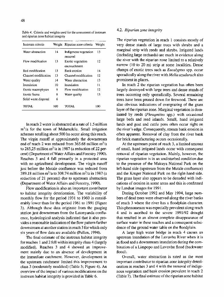
Table 4. Criteria and weights used for the assessment of instream and riparian zone habitat integrity
Instream criteria Weight Riparian zone criteria Weight
Water abstraction 14 Indigenous vegetation 13
removel
13 Exotic vegetation 12
encroachment
13 Bank erosion 14
13 Channel modification 12
14 Water abstraction 13
10 Inundation 11
9 Flow modification 12
8 Water quality 13
6
100 TOTAL 100
Flow modification
Bed modification
Channel modification
Water quality
Inundation
Exotic macrophytes
Exotic fauna
Solid waste disposal
TOTAL
In reach 2 water is abstracted at a rate of 1.5 million m3/a for the town of Malamulele. Small irrigation schemes totalling about 500 ha occur along this reach. The virgin runoff at approximately the downstream end of reach 2 was reduced from 365.68 million m3/a to 285,25 million m3/a in 1987 (a reduction of 22 per- cent) (Department of Water Affairs and Forestry 1990). Reaches 3 and 4 fall primarily in a protected area with no agricultural development. The virgin runoff just before the Mutale confluence was reduced from 389.18 million m3/a to 308.74 million m3/a in 1987 (a reduction of 21 percent) due to upstream abstraction (Department of Water Affairs and Forestry, 1990).
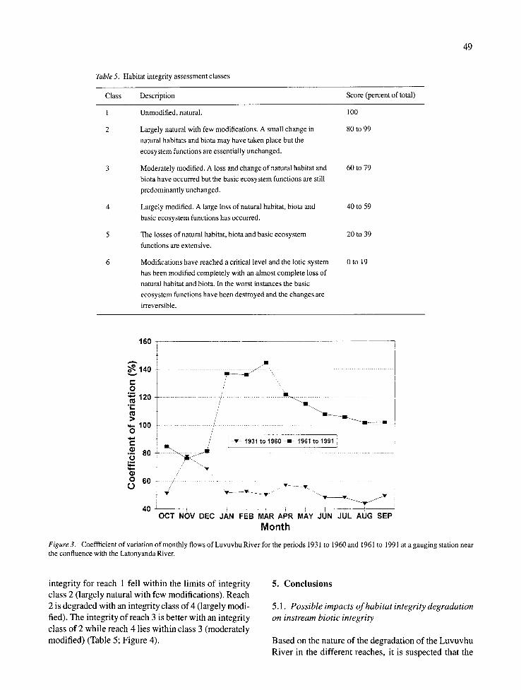
Flow modification is also an important contributor to habitat integrity deterioration. The variability of monthly flow for the period 1931 to 1960 is consid- erably lower than for the period 1961 to 1991 (Figure 3). Although these data originate from the gauging station just downstream from the Latonyanda conflu- ence, hydrological analysis indicated that it also pro- vides a reasonable indication of the flow pattern farther downstream at another station in reach 3 for which only six years of flow data are available (Pullen, 1994).
The final estimate of the instream habitat integrity for reaches 1 and 2 fell within integrity class 4 (largely modified). Reaches 3 and 4 showed an improve- ment mainly due to an absence of development in the immediate catchment. However, development in the upstream catchment limited this improvement to class 3 (moderately modified) (Table 5; Figure 4). An overview of the impact of various modifications on the instream habitat integrity is provided in Table 6.
4.2. Riparian zone integrity
The riparian vegetation in reach 1 consists mostly of very dense stands of large trees with shrubs and a marginal strip with reeds and shrubs. Irrigated lands (including large orchards) are much in evidence along the river with the riparian zone limited to a relatively narrow (10 to 20 m) strip at some localities. Dense clumps of exotic trees such as Eucalyptus spp. occur sporadically along the river with Melia azadarach also prominent in places.
In reach 2 the riparian vegetation has often been largely destroyed with large trees and dense stands of trees occurring only sporadically. Several remaining trees have been pruned down for firewood. There are also obvious indications of overgrazing of the grass layer of the riparian zone. Marginal vegetation is dom- inated by reeds (Phragmites spp.) with occasional large beds and reed islands. Small, hand irrigated lands and goat and cattle pens often occur right on the river's edge. Consequently, stream bank erosion is often apparent. Removal of clay from the river bank for brick manufacturing occurs occasionally.
At the upstream point of reach 3, a limited amount of small, hand irrigated lands occur with consequent removal of riparian vegetation. Mainly, however, the riparian vegetation is in an undisturbed condition due to the presence of the Makuya National Park on the left-hand side (upstream from the Mutale confluence) and the Kruger National Park on the right-hand side. The grass layer also appears to be denuded with indi- cations of erosion in some areas and this is confirmed by Landsat images for 1991.
During October 1992 and May 1994, large num- bers of dead trees were observed along the river banks of reach 3 where the river has a floodplain character. This phenomenon was especially prevalent along reach 4 and is ascribed to the severe 1991/92 drought that resulted in an almost complete disappearance of surface water in these reaches and a consequent subsi- dence of the ground water table on the floodplain.
A large high water bridge in reach 4 causes an upstream inundation of the Luvuvhu River when it is in flood and a downstream inundation during the com- bination of a Limpopo and Luvuvhu flood (backwater flood).
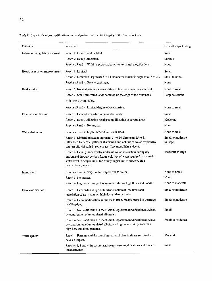
Overall, water abstraction is rated as the most important contributor to riparian zone integrity deteri- oration in reaches 3 and 4 with the removal of indige- nous vegetation and bank erosion prevalent in reach 2 (Table 7). The final estimate of the riparian zone habitat
49
Table 5. Habitat integrity assessment classes
Class Description Score (percent of total)
Unmodified, natural. 100
Largely natural with few modifications. A small change in 80 to 99
natural habitats and biota may have taken place but the
ecosystem functions are essentially unchanged.
Moderately modified. A loss and change of natural habitat and 60 to 79
biota have occurred but the basic ecosystem functions are still
predominantly unchanged.
Largely modified. A large loss of natural habitat, biota and 40 to 59
basic ecosystem functions has occurred.
The losses of natural habitat, biota and basic ecosystem 20 to 39
functions are extensive.
Modifications have reached a critical level and the lotic system 0 to 19
has been modified completely with an almost complete loss of
natural habitat and biota. In the worst instances the basic
ecosystem functions have been destroyed and the changes are
irreversible.
1 6 0
= • ' 1 4 0 . . . . . . . . . . . . . ~ ' ~ : . . . . . . . . . . . . .
O / , • E / • 1 2 0 . . . . . . . . . . . . . . . . . . . . . . . . , .......................... ~ . . . . . . . . . . . . . . .
~ - 1 0 0 ~ - . . . . . . . . . ,' . . . . . . O /
' E I / - • - 1 9 3 1 t o 1 9 6 0 - e l - 1 9 6 1 t o 1 9 9 1 1
._o "-= 80 - . . . . . . . . . . . . . . . . . .
O 6 0 - ~' . . . . . . . /// • • j . - - - -
4 0 I ] ] I I I J I I t ] I O C T N O V D E C J A N F E B M A R A P R M A Y J U N J U L A U G S E P
Month
Figure 3. Coeffficient of variation of monthly flows of Luvuvhu River for the periods 1931 to 1960 and 1961 to 1991 at a gauging station near the confluence with the Latonyanda River.
integrity for reach 1 fell within the limits of integrity class 2 (largely natural with few modifications). Reach 2 is degraded with an integrity class of 4 (largely modi- fied). The integrity of reach 3 is better with an integrity class of 2 while reach 4 lies within class 3 (moderately modified) (Table 5; Figure 4).
5. Conclusions
5.1. Possible impacts of habitat integrity degradation on instream biotic integrity
Based on the nature of the degradation of the Luvuvhu River in the different reaches, it is suspected that the
50
Table 6. Impact of various modifications on the instream habitat integrity of the Luvuvhu River
Criterion Remarks General impact rating
Water abstraction Reach l: Cultivated lands an indication of heavy abstraction; confirmed Serious
by hydrological records.
Reach 2: Absence of large scale irrigation but segments 6 to 16 still Large to serious
impacted by abstraction in reach 1. Contribution of perennial tributaries in
segments 17 and 18 results in less negative impact. Absence of perennial
tributaries and presence of small but intensive irrigation activities in
segments 19 and 20 again increase negative impact.
Reach 3: Within undeveloped area (National Park) but segments 21 to 29 Serious
still subjected to upstream abstraction and absence of perennial tributaries.
Negative impact increases from segment 21 to 29. Contribution of Mutale
River alleviates impact somewhat in segments 30 and 31.
Reach 4: Large volume of water required to saturate alluvial floodplain
before surface flow can occur. Upstream abstraction has a very high
negative impact.
Reach 1: Abstraction and weirs in tributaries cause an increase in
duration of dry season low flows with flow cessation occurring.
Reach 2: Impact still heavy but somewhat alleviated by the contributions
of perennial tributaries.
Reach 3: Segments 21 to 29 still heavily impacted by upstream
modifications and the absence of large tributaries. Segments 30 and 31
less impacted due to a contribution from the unregulated and relatively
undeveloped Mutale River.
Reach 4: Upstream modifications are not alleviated by any perennial Large
tributaries and a large high water bridge contributes to the modification of
the inundation pattern of the floodplain. The duration of low and no flow
conditions is considerably increased by upstream modifications.
Reach 1: Dense riparian vegetation maintains bank stability. Steep slope Small
of river prevents excessive sedimentation.
Reach 2: Subsistence farming on river banks causes denudation of Large
vegetation with a decrease in bank stability. Upstream water abstraction
limits river's ability to transport sediment. Increased sedimentation of
river bed indicated by large sand banks.
Reach 3: Upstream abstraction and absence of perennial tributaries from
segments 21 to 25 limit transporation of sediment originating in reach 2.
Sand banks less evident in segments 26 to 31 and flow from the Mutale
River also contributes to movement of sediment.
Reach 4: Floodplain associated with deposition of sediment. Additional Moderate
sedimentation not regarded as excessively negative to functioning of the
system.
Reach 1 : Few indications. Small
Reach 2: Over-utilization of river banks occur regularly. Moderate
Reaches 3 and 4: Only isolated cases of modification. Small
Flow modification
Bed modification
Channel modification
Serious, bordering
on critical
Large, bordering
on serious
Large
Moderate to large
Moderate to large
51
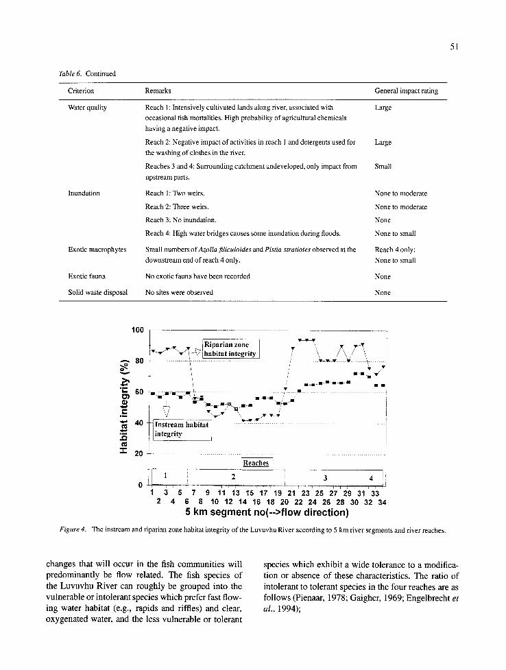
Table 6. Continued
Criterion Remarks General impact rating
Water quality Reach 1: Intensively cultivated lands along river, associated with Large
occasional fish mortalities. High probability of agricultural chemicals
having a negative impact.
Reach 2: Negative impact of activities in reach 1 and detergents used for Large
the washing of clothes in the river.
Reaches 3 and 4: Surrounding catchment undeveloped, only impact from Small
upstream parts.
Reach 1 : Two weirs.
Reach 2: Three weirs.
Reach 3: No inundation.
Reach 4: High water bridges causes some inundation during floods.
Small numbers of Azolla filiculoides and Pistia stratiotes observed at the
downstream end of reach 4 only.
No exotic fauna have been recorded
No sites were observed
Inundation
Exotic macrophytes
Exotic fauna
Solid waste disposal
None to moderate
None to moderate
None
None to small
Reach 4 only:
None to small
None
None
100
~'~'-~-~ iRii)arian zone r - . "7 /~ //~,~\
- - - 80 . . . . . . . . . . . . . . . . . . . . . . . . . . . . . . . . . . . . . . . . . . ! ' \
i
"m i "m '~vT~ =~-m / i i
4 0 I n s t r e a m h a b i t a t ~ . . . . . . . . . . . . . . . . . . . . . . . i i n t e g r i t y
.£2 f
"1- 2 0 + . . . . . . . . . . . . . . . . . . . . . .
i Reaches !
I i 2 3 ~ 1,
0 3 5 7 9 11 13 15 17 19 21 23 25 2'7 2~9 3'1 33 2 4 6 8 10 12 14 16 18 20 22 24 26 28 30 32 34
5 km segment no(-->flow direction)
Figure 4. The instream and riparian zone habitat integrity of the Luvuvhu River according to 5 km river segments and river reaches.
changes that will occur in the fish communities will predominantly be flow related. The fish species of the Luvuvhu River can roughly be grouped into the vulnerable or intolerant species which prefer fast flow- ing water habitat (e.g., rapids and riffles) and clear, oxygenated water, and the less vulnerable or tolerant
species which exhibit a wide tolerance to a modifica- tion or absence of these characteristics. The ratio of intolerant to tolerant species in the four reaches are as follows (Pienaar, 1978; Gaigher, 1969; Engelbrecht et al., 1994);
52
Table 7. Impact of various modifications on the riparian zone habitat integrity of the Luvuvhu River
Criterion Remarks General impact rating
Indigenous vegetation removal Reach 1: Limited and isolated. Small
Reach 2: Heavy utilization. Serious
Reaches 3 and 4: Within a protected area; no unnatural modifications. None
Reach 1: Limited. Small
Reach 2: Limited in segments 7 to 14, no encroachment in segments 15 to 20. Small to none.
Reaches 3 and 4: No encroachment. None
Reach 1: Isolated patches where cultivated lands are near the river bank. None to small
Reach 2: Small cultivated lands common on the edge of the river bank Large to serious
with heavy overgrazing.
Reaches 3 and 4: Limited degree of overgrazing.
Reach 1: Limited areas due to cultivated lands.
Reach 2: Heavy utilization results in modification in several areas.
Reaches 3 and 4: No impact.
Reaches 1 and 2: Impact limited to certain areas.
Reach 3: Limited impact in segments 21 to 24. Segments 25 to 3 l
influenced by heavy upstream abstraction and volume of water required to
saturate alluvial soils in some areas. Tree mortalities evident.
Reach 4: Heavily impacted by upstream water abstraction during dry
season and drought periods. Large volumes of water required to maintain
water level in deep alluvial for woody vegetation to survive. Tree
mortalities common.
Reaches 1 and 2: Very limited impact due to weirs.
Reach 3: No impact.
Reach 4: High water bridge has an impact during high flows and floods.
Reach 1: Occurs due to agricultural abstraction of low flows and
retardation of early summer high flows. Mostly limited.
Reach 2: Little modification in this reach itself, mostly related to upstream
modification.
Reach 3: No modification in reach itself. Upstream modification alleviated
by contribution of unregulated tributaries.
Reach 4: No modification in reach itself. Upstream modification alleviated
by contribution of unregulated tributaries. High water bridge modifies
high flow and flood patterns.
Reach 1: Farming and the use of agricultural chemicals are surmised to Moderate
have an impact.
Reaches 2, 3 and 4: Impact related to upstream modifications and limited Small
local activities.
Exotic vegetation encroachment
Bank erosion
Channel modification
Water abstraction
Inundation
Flow modification
Water quality
None to small
Small
Moderate
None
None to small
Small to moderate
to large
Moderate to large
None to Small
None
None to moderate
Small to moderate
Small to moderate
Small
Small to moderate
Reach 1, 5 intolerant, 19 tolerant
Reach 2, 3 intolerant, 22 tolerant
Reach 3, 3 intolerant, 31 tolerant
Reach 4, 1 intolerant, 25 tolerant
It is surmised that the current habitat integrity status of the river would during a cessation of flow, result in the disappearance of intolerant species from reaches 1 to 3. The tolerant species will be able to survive as long as pools with sufficient water depth and volume are avail- able and water quality is maintained within suitable limits. In the floodplain reach 4, the total disappear- ance of surface water will exterminate all fish. Such a situation prevailed during the 1991/92 drought.
It seems likely that intolerant species would be able to survive in refugia found in the perennial Latony- anada, Dzindi and Mutshindudi Rivers from where they will recolonize the Luvuvhu River when flow resumes. Indications that this is indeed the case were found in 1994 (Engelbrecht et al., 1994). Thus, the importance of these tributaries in the continued sur- vival of fish (and other aquatic biota) in the Luvuvhu River cannot be over emphasized. Recolonization of the floodplain will occur from reach 3 and perennial pools in the Limpopo River.
5.2. The prospects for the restoration of the Luvuvhu River
The Luvuvhu River is influenced by three completely contrasting landuse practices with entirely different impacts on the habitat integrity of the river. First there is the intensively utilized catchment along reach 1 with modem first world farming methods and with its associated environmental problems, e.g. the use of agricultural chemicals and excessive abstraction of water for irrigation during the low flow season or drought periods. Reach 2 stands in stark contrast with reach 1 and is mainly used for subsistence farming. Associated with this is a high degree of catchment and river mismanagement, e.g. overgrazing, removal of riparian vegetation, erosion, sedimentation, etc. The nett result of this to the human community along reach 2 is a high level of poverty and a gradual destruction of renewable resources. Again standing in contrast with both reaches 1 and 2 are reaches 3 and 4 which lie within a wilderness area of a National Park. Although largely undisturbed in several respects, these two reaches are nevertheless affected by the landuse prac- tices in reaches 1 and 2, e.g. water abstraction, flow modification, erosion, etc.
53
It is clear that an integrated management approach to the solution of the environmental problems in the Luvuvhu River is needed. This approach must empha- size the coherence between water quantity and quality management, between surface and groundwater management and between town and rural planning (Schneiders et al., 1993). One of the first priorities in the improvement of the habitat integrity of the Luvuvhu River can be the provision of storage facilities which can be used to regulate flow to prevent the excessive use of low flows and the cessation of flow downstream in the Kruger National Park.
5.3. Ecological integrity assessment in perspective
In South Africa, as is the case intemationally, there is considerable concern regarding the health, general well-being or condition of aquatic ecosystems. Conse- quently methods to assess the state of such systems are receiving attention with the aim to identify causative agents of modification and deterioration and ultimately to apply measures to improve the condition of these systems. For this purpose river conservation status estimation methods have been devised (e.g. O'Keeffe et al., 1987; Collier, 1993). Such methods can essen- tially be regarded as an assessment of the current status of a river compared against a hypothetically undis- tributed (pristine) state (Kleynhans, 1994). However, as Rapport (1992) points out, the total evaluation of ecosystem health will always be partly subjective. In addition, in developing countries in particular there is often a lack of any detailed information and the time and manpower required to obtain such data before the possible impacts of any additional development can be assessed. Nevertheless, the need for assessment methods are real and will grow as deterioration of aquatic ecosystems escalates. The characterization of the degradation process in rivers must also be analyzed to make possible the identification of early signs of deterioration and critical events in the process (Hilden & Rapport, 1993).
The method used for the determination of habitat integrity during this study does provide a wide, gen- eral perspective on the changes that took place in the river. However, due to the scale of the survey there is a general lack of quantification of the criteria used for impact assessment. Consequently this procedure is currently suitable as a first conceptual approach in the assessment of modifications on a macro habitat scale. It follows that for habitat integrity assessment required
54
on a finer scale, other methods such as the habitat quality index (Plafkin et al., 1989) should also be taken in account. This should be followed by an analysis of the aquatic communities, such as the fish based index of biotic integrity (Karr, 1981). Ultimately a suite of methods with an increasing degree of detail and quantification depending on the information require- ments needs to be employed in the total assessment of ecological integrity.
Acknowledgements
The contributions of the following persons in the deter- mination of the weights of river characteristics are gratefully acknowledged; Messrs A. Malan, A. Hoff- man, J. Engelbrecht, F. Roux, F. Rousseaux and G. Schulz. Messrs. N. Kemper and J. Engelbrecht assisted with the aerial survey. Dr H. van Vliet is thanked for comments on the draft manuscript. Mrs K. Erasmus was responsible for art work. This paper is published with the permission of the South African Department of Water Affairs and Forestry.
References
Collier, K., 1993. Towards a protocol for assessing the natural value of New Zealand Rivers. Science and Research Series no. 58. Department of Conservation, Wellington, New Zealand. 58 pp.
Dean, B. V. & M. J. Nishry, 1965. Scoring profitability models for evaluating and selecting engineering projects. J. Open Res. Soc. Am. 13: 550-569.
Department of Water Affairs and Forestry, 1990. Water resources planning of the Luvuvhu River Basin. Basin study report. Vol. 2. Main Report. DWA Report No. P.A900/00/0290, Pretoria, South Africa. 157 pp.
Department of Water Affairs and Forestry, 1993. South African Water Quality Guidelines. Vol 1. Domestic use. Pretoria, South Africa. 216 pp.
Engelbrecht, J. S., E Roux & A. H. Hoffman, 1994. A summa- rized assessment of the fish community of the Luvuvhu River (Limpopo System). Contribution to a workshop on the Luvuvhu River. Department of Water Affairs and Forestry. Pretoria, South Africa. 15 pp.
Gaigher, I. G., 1969. Aspekte met betrekking tot die ekologie, geografie en taksonomie van varswatervisse in die Limpopo- en Incomatiriviersisteem. (in Afrikaans). Ph.D.thesis, Rand Afrikaans University. Johannesburg, South Africa. 261 pp.
Gordon, N. D., T. A. McMahon & B. L. Finlayson, 1992. Stream Hydrology: An Introduction for Ecologists. John Wiley & Sons, Chichester, New York, Brisbane Toronto, Singapore, 529 pp.
Hilden, M. & D. Rapport, 1993. Four centuries of cumulative impacts on a Finnish river and its estuary: an ecosystem health approach. J. Aquat. Ecosyst. Health 2:261-275.
Karr, J. R., 1981. Assessment of biotic integrity using fish commu- nities. Fisheries 6:21-27.
Karr, J. R., 1993. Measuring biological integrity: Lessons from streams. In: S. Woodly, J. Kay & G. Francis (eds), Ecological Integrity and the Management of Ecosystems. pp. 83-104. St. Lucie Press.
Karl J. R. & D. R. Dudley, 1981. Ecological perspective on water quality goals. Environ. Manage. 5: 55-68.
Kleynhans, C. J., 1994. The assessment of conservation status for rivers. In: M. C. Uys (ed), Classification of Rivers, and Environmental Health Indicators. Proceedings of a joint South African/Australian workshop. Cape Town, South Africa. Water Research Commission Report No. Tl" 63/94.
Noble, R. G. & J. Hemens, 1978. Inland water ecosystems in South Africa - a review of research needs. South African National Scientific Programmes, Report 34, CSIR, Pretoria, South Africa 149 pp.
O'Keeffe, J. H. (ed.), 1986. The Conservation of South African Rivers. South African National Scientific Programmes Report 131, CSIR, Pretoria, South Africa. 117 pp.
O'Keeffe, J. H., D. B. Danilewitz & J. A. Bradshaw, 1987. An "Expert System" approach to the assessment of the conservation status of rivers. Biol. Conserv. 40: 69-84.
Pienaar, U. de V., 1978. The Freshwater Fishes of the Kruger National Park. Sigma Press, Pretoria. 91 pp.
Plafkin, L. P., M. T. Barbour, K. D. Porter, S. K. Gross & R. M. Hughes, 1989. Rapid bioassessment protocols for use in streams and rivers: benthic macroinvertrebrates and fish. U.S. Environmental Protection Agency. Washington, D.C.
Pullen, R. A., 1994. A review of the streamflow regime in the Luvuvhu River. Contribution to a workshop on the Luvuvhu River. Department of Water Affairs and Forestry. Pretoria, South Africa. 23 pp.
Rapport, D. J., 1993. Evaluating ecosystem health. J. Aquat. Ecosyst. Health 1: 15-24.
Regier, H. A., 1993. The notion of natural and cultural integrity. In: S. Woodly, J. Kay & G. Francis (eds), Ecological Integrity and the Management of Ecosystems. pp. 3-18. St. Lucie Press.
Schneiders, A., E. Verhaert, G. D. Blust, C. Wils, L. Bervoets & R. E Verheyen, 1993. Towards an ecological assessment of watercourses. J. Aquat. Ecosyst. Health 2: 29-38.
U.S. Army Corps of Engineers, 1980. A habitat evaluation system for water resources planning. Lower Mississippi Valley Division, Vicksburg, Mississipi.
Van der Merwe, W. & D. C. Grobler, 1990. Water quality manage- ment in the RSA: preparing for the future. WATER SA 16: 49-54.