Embed Size (px)
Citation preview
A proposed classification system of aquifers in Alberta Grant L. Nielsen Stantec Consulting Ltd. Red Deer, Alberta, Canada ABSTRACT A tentative system has been derived to classify aquifers having common characteristics within Alberta. The level of knowledge of their parameters varies greatly depending on past studies and utilization. Starting in the northeast, and going to the southwest, the Precambrian basement complex in northeast Alberta is virtually unknown hydrogeologically. The Proterozoic Athabasca Region south of Lake Athabasca consists of clastic redbeds with considerable drilling information available. The Devonian Region consists of carbonates and evaporates subject to scattered karst and permafrost. The Cretaceous-Paleocene Region extends from the American border to the North West Territories and has been intensively studied through hundreds of thousands of boreholes and thousands of aquifer tests. The Disturbed Belt of the foothills and Rocky Mountains are highly faulted and folded strata with mainly fracture permeability. Finally the Surficial Sand And Gravel Region extends throughout the province and includes materials of a variety of origins. RÉSUMÉ Un système provisoire de classification, regroupant les aquifères de caractéristiques communes, a été établi en Alberta. Le niveau de connaissances varie grandement en fonction des études antérieures et de l’utilisation des aquifères en question. Commençant dans le nord-est, l’hydrogéologie du complexe précambrien du nord-est de la province est presque totalement inconnue; alors que la région protérozoïque du groupe Athabasca, localisée au sud du Lac Athabasca et constituée de formations rouges clastiques, est très bien documentée grâce aux nombreux renseignements de forages disponibles. La région dévonienne est caractérisée par des carbonates et évaporites avec des aspects karstiques et de pergélisol. La région crétacée-paléocène, qui s’étend de la frontière américaine jusqu'aux Territoires du Nord-Ouest, est également très bien connue grâce à plusieurs centaines de milliers de forages et à des milliers d’essais de pompage. La région nommée « Zone Perturbée » du Piémont et des Rocheuses comprend des strates fortement plissées et faillées, avec une perméabilité principalement de fracturation. Finalement, la région des sables et graviers superficiels s’étend à travers la province et comprend des matériaux de plusieurs provenances. 1. INTRODUCTION In 2007, Wei et al presented a paper classifying the aquifers of British Columbia. With all the extensive knowledge now available on aquifers in Alberta, it appears that nobody had ever attempted a similar classification system for Alberta. This paper is a first attempt to do so. It is hoped that this paper will stimulate discussion and further study of the same theme. A classification system is an attempt to identify and describe common characteristics which help to better understand the commonalities within a hydrogeologic region and the basic differences between the different regions. This author has recognized six distinct regions, and will describe each in turn. Probably the earliest systematic attempt to collect and organize groundwater data in Alberta was a program of the federal government to collect information on water wells throughout the prairies during the 1930s. This data is of limited value today, as most wells at that time were shallow and dug by hand, and hence no longer exist. Scientific examination of Alberta’s hydrogeology was begun by the Alberta Research Council (ARC) in the 1960’s, and many of their reports are still standard references today. In the 1970s and 1980s, the ARC completed a mapping program of aquifer yields, water quality and locations of wells for almost the entire
province, with the exception of a few remote map sheets of northern Alberta. Upon completion of this monumental work, little more was done for some years. Of tremendous value to hydrogeological evaluations, the government of Alberta has required since the 1970s, that all newly drilled water wells be reported to the Province. There are now some 500,000 water well drillers’ reports on file with Alberta Environment’s Groundwater Information Services, with about 7,000 new wells added annually. During the last ten years, the federal Prairie Farm Rehabilitation Administration (PFRA) in cooperation with the counties and municipal districts has funded numerous regional studies, benefiting from an additional thirty years of data since the earlier studies. The counties which availed themselves of this program are mostly in the populated southern half of the province. This program is now complete. Most recently, the Alberta Geological Survey and the Geological Survey of Canada in Calgary have undertaken very detailed studies of areas of particular concern, such as the Cold Lake area, the bituminous oil sands area of northeast Alberta, and the Horseshoe Canyon and Paskapoo Formations, along the Edmonton-Calgary corridor. Alberta is highly diverse in its physical characteristics. Elevation ranges from less than 200 m in the extreme northeast to over 4000 m in the heights of the Rockies.
1183
GeoHalifax2009/GéoHalifax2009

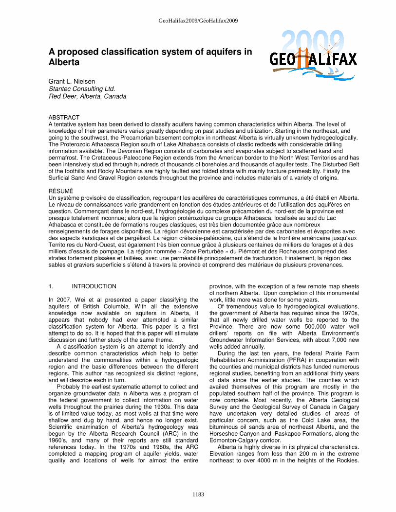
Precipitation ranges from near-desert conditions of 330 mm per annum near Medicine Hat to over 1000 mm in the Rockies. Geologically, Alberta has strata ranging from the Precambrian complexes of the northeast to Pleistocene and Recent deposits throughout the province (Hamilton, et al, 1999). Alberta’s preoccupation with groundwater may appear exaggerated to easterners. But with about ten percent of Canada’s population and seven percent of Canada’s land area, Alberta has just two percent of Canada’s surface water. Much of this two percent must be shared downstream with Saskatchewan, North West Territories and Montana. Although just three percent of Alberta’s water allocations are for groundwater, virtually all rural residents and most of the smaller towns and villages depend solely on groundwater supplies. Much of the South Saskatchewan basin in Southern Alberta is now closed to further surface water diversions, so the only additional water supplies must come from groundwater unconnected to surface water. Thus the classification, understanding and development of this resource are taking on a greater importance than ever before. This paper is a first attempt to classify the main aquifer regions of Alberta to support this goal (Figure 1).
Figure 1. Aquifer regions of Alberta Legend: 1: Precambrian basement complex 2: Athabasca Group region
3. Devonian region 4. Cretaceous-Paleocene region 4a: Paskapoo sub-region 5. Disturbed belt region 2. PRECAMBRIAN BASEMENT COMPLEX The Precambrian Basement Complex within Alberta is a relatively small portion of the Canadian Shield. Virtually no hydrogeological exploration has been carried out on the Precambrian within Alberta, because of lack of access, lack of population and hence lack of interest in the development of groundwater in this area. Godfrey mapped the geology of this area over many years (Godfrey, 1986). A part of this complex is composed of Archean granitoids, metamorphics, amphibolites and granite-gness. There is also an Aphebian area of metamorphics, granite and granodiorite. In the Western Canadian Sedimentary Basin, the Precambrian is considered to be the lower boundary of active groundwater movement. Hence in outcrop, the same complex may be considered to have very limited hydrogeologic potential. Permeability is limited to faulting and secondary fracturing of the rock, with minimal potential productive capacity. There is no doubt scattered permafrost in this region. 3. ATHABASCA GROUP REGION The Athabasca Group is present south of Lake Athabasca, with the largest portion present in Saskatchewan. The maximum thickness is about 1500 m at the centre of the basin. The Athabasca Group is composed mainly of clastic redbeds, the gamut ranging from shale and mudstone to conglomerate in composition, and is highly cemented to unconsolidated (Collier, B., 2005). However the Carswell Formation contains 400 to 500 m of algal and stromatolitic dolomites. Despite its carbonate nature, it is still unknown whether the Carswell has been subjected to solution and karst formation. Structure of the Alberta portion of the Athabasca Group is dominated by north-south to northwest-southeast sub-parallel faulting, which may dominate groundwater occurrence and movement (Post, 2004). This region has been intensively studied in the search for uranium for many years, and any knowledge gained of its hydrogeology is merely a byproduct of mineral exploration. Numerous core holes drilled in the 1960’s into the Wolverine Point Formation were flowing and continue to flow to this day. The water is saturated in iron and there are numerous limonitic contact spring deposits. Permafrost conditions exist in scattered areas. One licensed groundwater diversion is known in northern Saskatchewan, but there are none in Alberta. 4. DEVONIAN REGION
1184
GeoHalifax2009/GéoHalifax2009
The Devonian Region is exposed to the west of the Precambrian and also within the eroded valley of the Athabasca River near and north of the City of Fort McMurray (Figure 1). The Devonian Region is located at the eastern margin of the Western Canadian Sedimentary Basin and is the regional discharge zone for much of the Athabasca River basin. Hydraulic head from the Cariboo Mountains to the northwest and Birch Mountains to the southwest exceeds 600 m. The strata of this region consist of mainly of carbonates and evaporates (gypsum and halite). Around a hundred years ago, boreholes were drilled into Devonian outcrops along the Athabasca River north of the City of Fort McMurray in a futile search for the source of the bitumen exposed in the area. These boreholes flowed and continue to flow today with groundwater saturated in sodium chloride to calcium sulfate. Throughout the outcrop area, there are also karst features, saline springs and saline streams. Discontinuous permafrost is present, with temperatures documented as low as –4.8 degrees C observed at 128 m depth (Nielsen, 1972). 5. CRETACEOUS-PALEOCENE REGION 5.1 Upper Cretaceous subregion The Great Plains area of Alberta (Figure 1) extends from the semi-desert American border to the discontinuous permafrost area at the northern border. Most of this area is underlain by Cretaceous continental and less common marine clastic sediments, consisting of shale, mudstone, siltstone, sandstone and coal. The proportions vary in different formations. Typically, the sandstones are in the form of lenses within a shale/mudstone matrix. Sandstone is the most common aquifer, both through interstitial and fracture permeability. In such a large area and range of climates, there is of course a considerable range of water quality facies, depending to some extent on recharge rate and location in local or intermediate flow systems. However, contrasted with the Devonian region, chloride content in this subregion is extremely low, seldom greater than 100 mg/L. 5.2 Paskapoo subregion The Paskapoo Formation is present within the western part of the sedimentary basin, extending from south of Calgary to the Swan Hills in the north. It has been identified as one of the major aquifers of Canada and hence is currently being studied extensively by the Geological Survey of Canada and by the Alberta Geological Survey. The Paskapoo Formation consists of lenticular sandstone aquifers within a matrix of shale (Figure 2, Nielsen, 1963). Although there remains more to do, its geometry is relatively well-known thanks to several hundred thousand borehole records and thousands of consulting reports which have evaluated aquifer
parameters, chemical facies and to a much lesser extent the recharge. Individual well yields range from nil to over 6000 m3/day. The degree of fracturing of the aquifers appears to be the principal factor in determining the capacity of individual wells. A major focus of current investigations of the Alberta Geological Survey, Geological Survey of Canada, and universities in Alberta is to determine the limits to sustainable development of this aquifer. Another focus is to identify those areas in which further development is possible. 6. DISTURBED BELT REGION The Disturbed Belt is the zone of the Rocky Mountains and foothills (Figure 1), which is from 40 to 120 km wide, and is present along the western edge of the Great Plains in Alberta. It consists of late Proterozoic to Upper Cretaceous strata, most of which are sedimentary. Some of the formations present are the same ones which outcrop or are present at depth in the Great Plains. There are a few minor volcanic beds. This region includes intensely faulted and folded strata, with the preferential orientation of these thrust features parallel to the ranges of mountains, north-south to northwest-southeast. The compressive forces of mountain building appear to have compressed the strata also, such that there is generally very little primary permeability in any of the clastic formations. As a result, most permeability in clastic aquifers is secondary due to fracturing, and is extremely erratic in its distribution. Some of the Paleozoic calcareous formations however have developed extensive solution features such that there are major solution springs from the Crowsnest Pass in the south to Jasper National Park (Worthington, 1991). A well recently completed in karstic dolostone east of Banff was recently tested and has a capacity exceeding 6000 m3 /day. Because of the pronounced topography, most flow systems are local in nature, with water facies being predominantly calcium-magnesium bicarbonate in nature. Again, as in the Cretaceous – Paleocene Region, chloride is notably low or absent. 7. UNCONSOLIDATED AQUIFER REGION Although there are unconsolidated aquifers throughout Alberta overlying the aquifers of the other five regions, I have chosen to identify them as a separate region, because of their distinct occurrence and distinct geochemistry. Figure 3 shows their distribution. It has been prepared from numerous individual regional studies dating from the 1970’s to the present. Because of their complexity, it is not been possible at this time to distinguish the individual types of unconsolidated aquifers. In addition, interpretations naturally have varied over the years and among the different authors. Much of northern Alberta is still terra incognita with respect to its unconsolidated aquifers.
1185
GeoHalifax2009/GéoHalifax2009
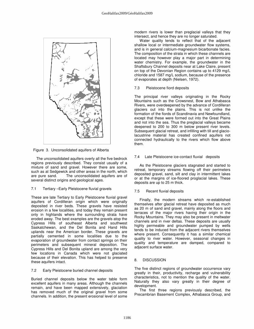
Figure 3. Unconsolidated aquifers of Alberta The unconsolidated aquifers overly all the five bedrock regions previously described. They consist usually of a mixture of sand and gravel. However there are some, such as at Sedgewick and other areas in the north, which are pure sand. The unconsolidated aquifers are of several distinct origins and geological ages. 7.1 Tertiary –Early Pleistocene fluvial gravels
These are late Tertiary to Early Pleistocene fluvial gravel aquifers of Cordilleran origin which were originally deposited in river beds. These gravels have resisted erosion in a few localities, and today they remain present only in highlands where the surrounding strata have eroded away. The best examples are the gravels atop the Cypress Hills of southeast Alberta and southwest Saskatchewan, and the Del Bonita and Hand Hills uplands near the American border. These gravels are partially cemented in some localities due to the evaporation of groundwater from contact springs on their perimeters and subsequent mineral deposition. The Cypress Hills and Del Bonita upland are among the very few locations in Canada which were not glaciated because of their elevation. This has helped to preserve these aquifers intact. 7.2 Early Pleistocene buried channel deposits
Buried channel deposits below the water table form excellent aquifers in many areas. Although the channels remain, and have been mapped extensively, glaciation has removed much of the original gravel from some channels. In addition, the present erosional level of some
modern rivers is lower than preglacial valleys that they intersect, and hence they are no longer saturated. Water quality tends to reflect that of the adjacent shallow local or intermediate groundwater flow systems, and is in general calcium-magnesium bicarbonate facies. The composition of the strata in which these channels are located may however play a major part in determining water chemistry. For example, the groundwater in the Shaftsbury Channel deposits near at Lake Claire, present on top of the Devonian Region contains up to 4129 mg/L chloride and 1587 mg/L sodium, because of the presence of evaporates at depth (Nielsen, 1972). 7.3 Pleistocene fiord deposits
The principal river valleys originating in the Rocky Mountains such as the Crowsnest, Bow and Athabasca Rivers, were overdeepened by the advance of Cordilleran glaciers out into the plains. This is not unlike the formation of the fiords of Scandinavia and Newfoundland, except that these were formed out into the Great Plains and not into the sea. Thus the preglacial valleys became deepened to 200 to 300 m below present river levels. Subsequent glacial retreat, and infilling with till and glacio-lacustrine material has created confined aquifers not connected hydraulically to the rivers which flow above them. 7.4 Late Pleistocene ice-contact fluvial deposits
As the Pleistocene glaciers stagnated and started to retreat, temporary streams flowing off their perimeters deposited gravel, sand, silt and clay in intermittent lakes or at the margins of ice-floored proglacial lakes. These deposits are up to 25 m thick. 7.5 Recent fluvial deposits
Finally, the modern streams which re-established themselves after glacial retreat have deposited as much as 20 m of sand and gravel, mainly along the floors and terraces of the major rivers having their origin in the Rocky Mountains. They may also be present in meltwater channels and in river deltas. These deposits are usually highly permeable and groundwater pumped by wells tends to be induced from the adjacent rivers themselves where present. Consequently it has a similar chemical quality to river water. However, seasonal changes in quality and temperature are damped, compared to adjacent surface water. 8. DISCUSSION The five distinct regions of groundwater occurrence vary greatly in their, productivity, recharge and vulnerability characteristics, not to mention the quality of the water. Naturally they also vary greatly in their degree of development. The first three regions previously described, the Precambrian Basement Complex, Athabasca Group, and
1186
GeoHalifax2009/GéoHalifax2009

the Devonian Region are virtually undeveloped at present. Indeed their hydrogeologic parameters are so far virtually unknown except in a very general sense. However oil sands development adjacent at the southern extension of the Devonian Region is beginning to impact this region as the oil sands are removed through surface mining of the bitumen resource. This activity is likely changing the nature of regional flow systems and hence the quality of the groundwater in the Devonian Region. Considerable attention has been given to the impact of oil sands mining on the Cretaceous and unconsolidated aquifers of northeast Alberta, but the impact on the Devonian Region has received little or no attention to date. Almost the entire population of Alberta lives in the Paleocene-Cretaceous region. As this is by far the most utilized area of groundwater use, this region is the best known in terms of its productive capacity, hydraulic parameters and water quality. Future development in this region will have to focus on locating the most productive zones, better methods of evaluating long-term productivity, sustainability, evaluation of recharge and protection of the resource from contamination. The Disturbed Belt Region is still little understood hydrogeologically, because no permanent land occupation is permitted in most of this region. Much is within threel national parks and most of the rest lies within the Alberta government’s “Green Zone”, where no private land ownership is permitted. Only land in the far southern portion of the province and the Crowsnest Pass and Bow Valley corridors is largely in private hands. Development of recreational subdivisions with a multiplicity of wells is beginning to yield a better understanding of this area. The Unconsolidated Aquifer Region faces many challenges. Because most of the aquifer intervals are at or just below the surface, they are extremely vulnerable to changes of land use and contaminant spills, principally related to hydrocarbons. The major cities are thirsty for construction aggregate, hence some of these shallow laterally extensive aquifers are literally being mined out of existence. Others are being paved over through urban growth, effectively reducing or eliminating recharge. Thus there are numerous conflicts between the numerous
stakeholders who want, on one hand to protect and sustain use of these aquifers, and on the other hand would prefer to exploit them for their immediate value in construction. 9. REFERENCES
Collier, B. 2005. Sequence stratigraphy and its use to uranium exploration in the Western Athabasca basin of Alberta and Saskatchewan; Alberta Geological Survey, Earth Science Report 2004-01
Godfrey, J.D. 1986. Geology of the Precambrian shield in
northeast Alberta; Alberta Research Council, Map 180, Edmonton, AB
Hamilton, W.N, Price, M.C., and Langenberg, C.W.
(compilers). 1999. Geological map of Alberta; Map 236, Alberta Geological Survey, Edmonton, AB.
Nielsen, G.L. 1963. Groundwater resources of the
Blindman River valley; M.Sc. thesis, University of Alberta, Edmonton, AB
Nielsen, G.L.1972. Final report, Peace-Athabasca delta
study, Section J, May, 1972, Edmonton, AB Post, R.T. 2004. Stratigraphy and sedimentology of the
Athabasca Group in the Net Lake – Maybelle River area, Northeast Alberta; Alberta Geological Survey Earth Sciences Rept. 2003-01, December, 2004
Wei, M., Ronneseth, K., Kohut, A.P., Turner, B., and
Grasby, S. 2007. Types and general characteristics of aquifers in the Canadian cordillera hydrogeologic region, OttawaGeo2007, pp. 9 - 16
Worthington, S.R. H. 1991. Karst hydrogeology of the
Canadian Rocky Mountains; Ph.D. thesis, McMaster University, Hamilton, ON
Figure 2. Lenticular sandstone aquifers within Paskapoo Sub-region (from Nielsen, 1963)
1187
GeoHalifax2009/GéoHalifax2009