Embed Size (px)
Citation preview

NCSU-MEAS AUMAN LAKE PROPOSAL – 1/19/2021 1
A Proposal to Evaluate Natural (wind) and Anthropogenic (boat) Wave Energy and its Impacts at Auman Lake, Moore County, North Carolina
1. Introduction
Large lakes and reservoirs in North Carolina serve as focal points for recreation, fishing, flood reduction, natural resource conservation, municipal drinking water sources, and increased property values (Voil et al., 2013). Regional population growth and advancements in watercraft design and technology mean that there are more boats than ever before plying the inland waters, ranging from single-user sit-on-top kayaks to multi-user wake-surf and pontoon boats. As boat density increases, there is a need for scientific studies to evaluate the variable impacts that power craft may have on the natural resources, ecology, and the built environment (infrastructure) associated with the lakes and reservoirs of the state (Riungu et al., 2020; Bilkovic et al., 2019). This research proposal derives from a desire to address citizen questions and concerns about the potential impact on the nearshore infrastructure and natural environment resulting from powerboat usage at Auman Lake, a ~800-acre reservoir in the Sandhills region of Moore County, North Carolina.
Around the country, lake-adjacent property owners, municipal and state government agencies, citizen organizations, scientists, and engineers have begun to question the extent to which powerboat wakes and prop wash may cause detrimental impacts to lakes. The size, power, and density of recreational boats on lakes have increased in recent years. For example, in 2020, Auman Lake had 534 registered powerboats, and the number has been increasing at an annual rate of ~1% since 2015. This density represents about one boat for every acre and a half of the lake's surface area.
At Auman Lake, as at many other lakes around the country, there is a need to characterize the ambient (natural) and boat-generated wave propagation dynamics and seasonal wave energy transfer to the
NCSU-MEAS AUMAN LAKE PROPOSAL – 1/19/2021 2
nearshore environment. Answering citizen concerns about potential impacts requires collecting environmental data, such as boat usage statistics, local meteorology, wave parameters (amplitude, height, velocity), along with prop-wash penetration depth, lake-bottom current velocities, and hydroacoustic variability. Acquisition of these data is important for assessing the severity of boat wakes to the built and natural environment. These data could help evaluate infrastructure damage, such as erosion of the dam face or the cyclical stress fatigue experienced by bulkheads and docks, to whether or not changes in water clarity result from resuspension of nutrient-rich bottom sediments by prop wash, as well as characterizing ecological impacts to submerged aquatic vegetation or the nesting sediments used by game fish.
The proposed collection of 12 months of data at Auman Lake will allow for a fuller description of the impact of boat wakes and prop wash on the bed and shoreline environments and facilitate comparisons to the annual and storm-specific wind-driven wave energy dynamics that the lake experiences. In turn, the analysis and reporting of the data by faculty and graduate students of the Department of Marine, Earth, and Atmospheric Sciences at NC State University, in partnership with citizens concerned about the lake's sustainability and management, will assist the community and the board of the Seven Lakes West Homeowners Association in making informed decisions about the collective management of their most precious resource.
2. Study Area
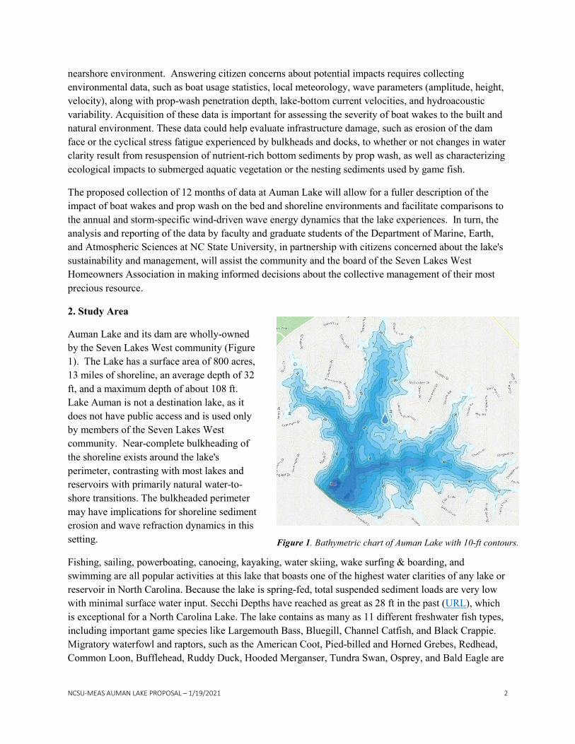
Auman Lake and its dam are wholly-owned by the Seven Lakes West community (Figure 1). The Lake has a surface area of 800 acres, 13 miles of shoreline, an average depth of 32 ft, and a maximum depth of about 108 ft. Lake Auman is not a destination lake, as it does not have public access and is used only by members of the Seven Lakes West community. Near-complete bulkheading of the shoreline exists around the lake's perimeter, contrasting with most lakes and reservoirs with primarily natural water-to-shore transitions. The bulkheaded perimeter may have implications for shoreline sediment erosion and wave refraction dynamics in this setting.
Fishing, sailing, powerboating, canoeing, kayaking, water skiing, wake surfing & boarding, and swimming are all popular activities at this lake that boasts one of the highest water clarities of any lake or reservoir in North Carolina. Because the lake is spring-fed, total suspended sediment loads are very low with minimal surface water input. Secchi Depths have reached as great as 28 ft in the past (URL), which is exceptional for a North Carolina Lake. The lake contains as many as 11 different freshwater fish types, including important game species like Largemouth Bass, Bluegill, Channel Catfish, and Black Crappie. Migratory waterfowl and raptors, such as the American Coot, Pied-billed and Horned Grebes, Redhead, Common Loon, Bufflehead, Ruddy Duck, Hooded Merganser, Tundra Swan, Osprey, and Bald Eagle are
Figure 1. Bathymetric chart of Auman Lake with 10-ft contours.
NCSU-MEAS AUMAN LAKE PROPOSAL – 1/19/2021 3
seasonally observed at the Lake, as are numerous endemic species of amphibians and reptiles (e.g., turtles). Indeed, the fauna in and around Auman Lake is a cherished natural resource enjoyed by many residents. Sustainable populations of invertebrates, amphibians, reptiles, fish, birds, and small mammals all rely upon Auman Lake's habitats and ecology. Anthropogenic activities may have detrimental impacts on the lake's various ecosystem services and its nearshore environs.
3. Study Design
Based on conversations with residents living at Auman Lake, we have identified the following scientific data collection needs:
1. Boat statistics on the type and number of watercraft utilizing the lake. 2. Ambient wind-driven wave energy. 3. Watercraft-induced wake energy. 4. Maximum depth of boat prop thrust (wash) induced bottom currents capable of entraining sediment
(erosion). 5. Characterization of shoaling waves (period, amplitude) and their energy transfer to bulkheads. 6. Differentiation between natural and boat-generated wave energy expenditure on bulkheads. 7. Characterization of nearshore sediment transport capacity from waves (wave parameters + sediment
grain size and compaction). 8. Evidence for or against wave or prop-wash disturbance of submerged aquatic vegetation. 9. A baseline photo-bathymetry survey of the dam's shallow submerged portion to characterize or
refute evidence for wave-induced erosion. 10. Underwater photogrammetry of all study sites where instruments are deployed.
We propose to deploy suites of geophysical instruments at six monitoring sites for 12 months. These monitoring sites will include one on the lakeside of the dam, one on the northwest corner of Pine Island, two more at exposed headlands proximal to the main ski/wake area, and one in a bay with an opening pointed towards the ski/wake area and one with a more protected configuration as a control site (Figure 2).
3.1 Instrumentation at Proposed Study Sites
The proposed 12-month, six-site instrument deployment scheme is designed to maximize data collection and the community's return on investment. Our research goal is to collect and interpret the types and amounts of data needed so that the community can answer their lake-utilization questions and derive science-based policy. The clocks of all instruments will be synchronized before deployment so that data from different sources is comparable.

NCSU-MEAS AUMAN LAKE PROPOSAL – 1/19/2021 4
3.2.1 Site 1 – Auman Lake Dam
The Auman Lake dam was constructed in the 1980s. It is an earth embankment dam with a clay core and was designed to have a 2:1 slope on the lake-facing side. The dam is c. 2,580' long and supports a head difference of 88' between the main vertical spillway (525.21' above sea level – asl) and the egress pipe at the base of the dam (437' asl). After dam construction, wave protection rip-rap (large boulders) was placed on the dam's lakeside from the crest down to ~6 ft below normal pool elevation (~519' asl). There are reports that water level fluctuations, possibly caused by large wakes, have compromised the integrity of the wave protection rip-rap in places. The dam also faces the second-longest fetch distance (~7,700 ft) available at Auman Lake (Figure 2). Sustained NNW winds would likely generate the largest natural waves that could impact the dam's upper shore face.
Figure 2. Location of proposed instrument deployment sites at Auman Lake, including the dam (site 1), Pine Island (site 2), two additional exposed headlands (sites 3 and 4) and within two bays, one oriented towards the ski/wake zone (site 5) and one in a protected (control) location (site 6). We propose to deploy, maintain, and monitor the instrument sites for 12 months.

NCSU-MEAS AUMAN LAKE PROPOSAL – 1/19/2021 5
At Site 1, we propose to install a Spotter buoy to monitor surface wave action within the lake (Figure 3). The Spotter buoy is solar-powered and delivers real-time wave (height, period, and direction) and water temperature data over an Iridium Satellite network connection. These data will be made available via a public-facing website for community engagement throughout the research project. The Spotter buoy logs the full 3D displacement time series (x,y,z sampled at 2.5 x per second) of the lake surface to a local memory card that will be retrieved periodically. The device will monitor wind-generated and boat-induced waves near the southern end of the ski/wake zone and in front of the dam. The buoy's surface footprint is small (16' wide and 6" above the waterline), and it is brightly colored with a flashing LED visibility light to alert approaching boaters of its position. This instrument would be anchored on the lake bed ~ 200 ft offshore from the dam in ~ 40 ft of water. The buoy will be placed ~200' off from the dam to facilitate anchor placement on a more flat part of the lake bed, off of the 2:1 slope of the dam face itself. The 200' offset will also help to minimize wave chop from waves reflected off of the dam.
A Raspberry Shake 4D all-axis strong-motion seismograph will be installed on the dam's crest in line with the Spotter buoy. The seismograph will be installed in a shallow trench to enhance coupling of the instrument to the ground. These instruments measure the earth's movement from natural and induced (anthropogenic) sources of seismic energy and records at a frequency of 100 Hz, which will be more than adequate to detect individual waves impacting the dam. The strong-motion seismograph will be able to detect wind and boat waves, pedestrians walking on the dam, and far-field energy sources, such as explosions at Fort Bragg and even distant earthquakes. Algorithms exist that allow for the differentiation of these different seismic energy sources. The seismometer placement on the dam will allow for the
Figure 3. Instrumentation Site 1at the Auman Lake Dam. Site 1 will include a Raspberry Shake 4D Strong Motion Seismograph (RS-4D) and a remote camera on the crest of the dam. A Spotter wave buoy will be located approximately 200’ offshore in c. 40 foot-deep water. An underwater drone will be used to investigate the structural integrity of the submerged portion of the wave protection rip-rap.
NCSU-MEAS AUMAN LAKE PROPOSAL – 1/19/2021 6
characterization of the daily energy load imparted to the dam from incoming waves that are also being tracked by the Spotter buoy ~200' offshore (e.g., Adams et al., 2002). While the energy transfer from the waves to the dam is not likely to cause structural integrity issues, we will characterize cyclical energy variations at the shore face as a function of season, time of day, weather condition, and real-time boat density and type information.
The number and type of boats will be recorded by a lake-facing remote outdoor construction-site/security camera installed next to the seismometer (Figure 3). The camera will be programmed to capture digital images every 15 seconds during daylight hours (~2400 photos per day) and save them to an internal micro-SD memory card. A deep-learning object detection model will be trained to identify different classes of boats from these images automatically (e.g., Yang et al., 2018). These observations, coupled with the wave buoy and seismograph data, will quantify the wave activity and energy transfer associated with different watercraft and boating activities and the background weather-generated waves at the lake. Combining data from the Spotter buoy, the seismograph, and the camera (see below), we will be able to differentiate wave types impacting the dam face based upon their period, velocity, and energy (e.g., Hofmann et al., 2008).
At Site 1, an underwater drone will be deployed to photo document the nearshore bathymetry along the dam's face. These images will be mosaicked together into a georeferenced photomap. While it is impossible to know when areas of erosion along the dam face might have occurred in the past, collecting these data will serve as a reference for future repeat surveys to assess the structural integrity of the wave protection rip-rap (e.g., Chrzastowski, 1989). The underwater drone also will be utilized at all study sites to ensure proper instrument placement on the lake bottom. We will utilize the drone to document lake bottom sediment characteristics and disturbance from prop-wash, waves, and wakes at all study site locations. We also plan to use the drone for mini-experiments were at varying water depths we test for and record the Bottom Tilt-Current Meters movement (see section 2.2.2) and whether or not sediment disturbance occurs in response to the overhead passage of different watercraft types.
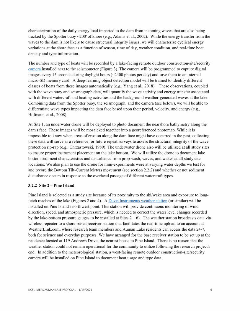
3.2.2 Site 2 – Pine Island
Pine Island is selected as a study site because of its proximity to the ski/wake area and exposure to long-fetch reaches of the lake (Figures 2 and 4). A Davis Instruments weather station (or similar) will be installed on Pine Island's northwest point. This station will provide continuous monitoring of wind direction, speed, and atmospheric pressure, which is needed to correct the water level changes recorded by the lake-bottom pressure gauges to be installed at Sites 2 – 6). The weather station broadcasts data via wireless repeater to a shore-based receiver station that facilitates the real-time upload to an account at WeatherLink.com, where research team members and Auman Lake residents can access the data 24-7, both for science and everyday purposes. We have arranged for the base receiver station to be set up at the residence located at 119 Andrews Drive, the nearest house to Pine Island. There is no reason that the weather station could not remain operational for the community to utilize following the research project's end. In addition to the meteorological station, a west-facing remote outdoor construction-site/security camera will be installed on Pine Island to document boat usage and type data.
NCSU-MEAS AUMAN LAKE PROPOSAL – 1/19/2021 7
Off the northwest point of Pine Island, we will submerge an instrument array (Figure 4). The array will consist of three different types of instruments. First will be four in-house custom-built water pressure gauges capable of recording water level (wave) height changes at the rate of 20 cycles per second (Hz), sufficient to characterize the dynamics (wavelength, amplitude, and celerity) of lake waves (Temple et al., 2020). The pressure gauges will be placed in water depths of ~30', 20', 10', and 3' to characterize the transition from open-water to shoaling or breaking wave behavior (Bagnold, 1940). The cumulative energy impacting Pine Island's west-to-northwest facing bulkhead will be calculated from the periods and heights of the incoming wave field and recorded by a Rasberry Shake 4D seismograph installed on or just behind the bulkhead.
The second instrument in the array will be a Lowell Instruments Tilt Current Meter. The instrument contains a 3-axis accelerometer and 3-axis magnetometer for measuring the buoyant sensor tube's tilt and bearing in response to current drag forces experienced just above the lake bottom. Tilt meters are a low-cost alternative to an acoustic Doppler current meter. It is designed primarily to monitor stationary flow but also responds to orbital flows (Lowell et al., 2015; Radermacher et al., 2015). The current meters will be co-located with the bottom pressure sensors at 30, 20, and 10-foot water depths, such that they are in water deeper than the wave base (1/2 the wavelength) of the largest waves (as determined using measurements of the Spotter buoy). At these depths, the sensor will record prop-wash-induced bottom currents instead of the shoaling effect of waves as they approach the shore. If significant bottom currents are detected at the 30' depth location, we may reposition the outer current meter to estimate a threshold
Figure 4. Cartoon of instrumentation set-up at Site 2 – Pine Island. We will deploy 4 bottom water pressure sensor gauges (BPS), three bottom tilt current meters (CM), and one acoustic underwater hydrophone off the northwest corner of Pine Island in water ranging from 30 to 3 feet deep. On the bulkhead, we will install a RS-4D seismograph. A Davis instruments weather station and remote camera will also operate from the northwest corner of the island. The underwater drone will be used for photo documentation of each site at the beginning, middle, and end of the study period.
NCSU-MEAS AUMAN LAKE PROPOSAL – 1/19/2021 8
depth (convertible to a distance from the shore using bathymetric maps) below which prop wash has no demonstrable effect on the remobilization of lake-bottom sediments. Bottom sediments are often rich in organic carbon and absorbed phosphorus (e.g., Kim et al., 2003; Haggard, et al., 2005). Transport of nutrient-laden sediments off the lake bed up into the photic zone can drive algal blooms, which reduce water clarity, and upon death and decay, can decrease dissolved oxygen levels in the water column. Rapid decreases in dissolved oxygen is a common cause of fish kill events in lakes and estuaries (Kangur et al., 2016).
The third instrument in the Pine-Island array will be an Endurologger Acoustic Hydrophone. This device is capable of recording the Auman Lake soundscape. Soundscapes comprise biological, physical, and human-produced sounds (e.g., Bohnenstiehl et al., 2018). We have two main interests in recording the Auman Lake soundscape. The first priority is to test whether we can use sound loading to estimate the boat density on the lake for a given period (e.g., 30 minutes). By comparing the remote camera records of boat density and type to the soundscape's motorized component, we might be able to derive regression equations that would allow for passive monitoring and estimation of total lake boat usage as a function of ambient noise levels through time (e.g., Pollara et al., 2017). We also anticipate being able to differentiate boat types based upon their differing acoustic signatures.
Our second objective is to understand the biological components of the soundscape better. Aquatic organisms are continually receiving sensory information about their environment from the ambient soundscape, and the underwater soundscape reflects the combination of sources present in a given habitat and therefore is an information-rich sensory signal. Dr. Bohnenstiehl is an expert in aquatic soundscape ecology, and we see an opportunity to bring his expertise into the freshwater environment, where very few studies have been conducted. For example, we know that fish communicate via sound (Ladich, 2019), and the Centrachidae fishes in the lake (bass, bluegill, crappie) build and guard communal nests during breeding and rearing periods (Gerald, 1971). What impact might motorized noise have on these fish during their breeding period? Is there evidence that they exhibit behavioral changes associated with different sound frequencies or levels in the water column? To our knowledge, no one has performed these types of experiments before in freshwater settings.
3.2.3 Sites 3-4 – Exposed Headlands
In consultation with the Auman Lake community, understanding the impact of waves on sediment erosion and infrastructure is critical (e.g., Powell, 1958). Portions of the shoreline exposed to long fetch and the ski/wake area are most likely to experience enhanced wave activity and cyclical stresses on engineered structures (e.g., bulkheads, docks, boat lifts, etc.). In addition to the northwest point of Pine Island, we propose to instrument two additional headland locations (Figures 2 and 5). We will deploy a pressure gauge and a bottom current meter in ~ 10 ft of water depth at these headland sites. These instruments will measure the incoming surface wave height, period, celerity, and bottom current velocities. They will allow us to test the null hypothesis that proximal to the shoreline, prop-thrust bottom current velocities are not great enough to initiate sediment mobilization and erosion (Hong et al., 2013). The erosion of lake bottom sediments depends upon the velocity of the bottom current, the grain size of the sediment, and how compact it is (Sumer, 2002). We will collect sediment samples from these and other study sites to quantify these parameters and provide input into standard marine (lake) sediment transport equations (Fredsøe and Deigaard, 1992). By collecting 12 months of data, we will estimate the fraction of the year,

NCSU-MEAS AUMAN LAKE PROPOSAL – 1/19/2021 9
if any, when bottom current velocities are great enough to exceed the threshold for sediment erosion in the nearshore.
Raspberry Shake 4D seismographs will also be installed on or just behind intact bulkheads at each exposed headland site. As at the Dam and Pine Island sites, the seismographs will allow for the characterization of the energy load imparted to these structures from impacting waves. We are particularly interested in comparing the force applied to bulkheads from waves generated by different sources (wind, boat type) and their respective cumulative annual loading. For example, what is more detrimental to infrastructures like bulkheads, waves generated by the passage of a tropical storm over the Sand Hill region, or the cumulative effects of waves generated during the boating season? With a little luck (proximal tropical storm), we will answer this question through the deployment of the seismographs on the bulkheads, the wave buoy, remote cameras, and bottom pressure gauges.
The exposed headland sites will require direct coordination with amenable property owners wishing to participate in the study.
3.2.4 Sites 5-6 – Bays (ecological hot spots).
The third location where instruments will be deployed is in the shallower ends of two bays, in water 4 to 8 feet deep (Figures 2 and 6). One bay will be selected that is oriented with its opening directly towards the ski/wake area, and the other will be installed as a control site in a bay with an orientation more protected from the ski/wake area. The instrument set-up will consist of a tilt current meter, a bottom pressure gauge, and a hydrophone (at one of the two sites). These instrument arrays will facilitate the characterization of variability in physical parameter space (e.g., wave energy and bottom currents, sediment transport, and
Figure 5. Cartoon of instrumentation set-up at Exposed Headland Sites 3 and 4. Underwater we will deploy a bottom pressure sensor gauge and a tilt current meter. A RS-4D seismograph will be installed on or adjacent to the bulkhead. The underwater drone will be used for photo documentation of each site at the beginning, middle, and end of the study period.

NCSU-MEAS AUMAN LAKE PROPOSAL – 1/19/2021 10
soundscapes) in locations that have a more significant proportion of surface area underlain by relatively shallow water depths, and thus higher overall biological productivity (e.g., submerged aquatic vegetation, fish spawning nests, etc.).
3.3 Locating Sites for Instrument Deployment
The location of proposed instrument deployment sites portrayed on figure 2 is only for demonstration purposes. The specific locations will be coordinated through consultation with the Seven Lakes West Home Owners Association Board and directly with residents wishing to participate in this study. At two of the three 'exposed headland' sites, we wish to install Raspberry Shake seismographs either on the bulkhead or just on the landward side (lawn) to measure the cyclic loading from wind-and-boat driven waves over the 1-year study. The on-shore placement of these instruments would need to have the agreement and cooperation of the homeowner. If the homeowners were willing to provide access to an outdoor electrical outlet to power the seismographs, we could save on solar panel expenses at two of the sites.
Figure 6. Cartoon of instrumentation set up at one of two Bay sites. Deployed instruments will consist of a bottom pressure sensor gauge, tilt current meter, and an acoustic hydrophone. The underwater drone will be used for photo documentation of each site at the beginning, middle, and end of the study period.

NCSU-MEAS AUMAN LAKE PROPOSAL – 1/19/2021 11
4. Timeline & Deliverables
We propose to collect 12 months of data at Auman Lake from June 2021 to June 2022 and for the full project to extend from approximately March 15, 2021, to September 30, 2022.
March 15 to June 1, 2021: Project Startup. Instrument acquisition, fabrication, and lab testing. June 1 to 30, 2021: Instrument deployment and field testing, beginning with Site 1, and expanding to Sites 2 – 6. Establishment of near-real-time Spotter wave buoy and meteorological station data on public-facing websites. June 2021 to June 2022 Monthly to bi-monthly visits by research team members for instrument maintenance, battery swaps, and data download. The operation of the above-water instrumentation (e.g., cameras and weather station) could benefit if one or more local residents "adopted" them by agreeing to weekly checks to verify that the devices are operating and collecting data. If a device failure occurs, we will be able to repair or replace it without losing too much down-time. December 31, 2021: Interim report of activities and results to SLWHA Board. June, 2022: Demobilization of instruments and end-of-data collection. July 31, 2022: Second Interim report of activities and results to SLWHA Board September 30, 2022: Final report of results and presentation to SLWHA Board and Auman Lake Community. Electronic data transferred to SLWHA Board. March 2023: Chris Norcross defends and completes M.S. thesis and presents it to SLWHA Board; Preparation of manuscript(s) for submission to peer- review journal; Presentation of results at scientific conferences and Workshops. Note: If delays occur in our ability to acquire and report on data from this project, no additional funds would be requested from the Seven Lakes West Home Owners Association. Instead, we would request a "no-cost-extension" to allow for the study's continuation and completion. 5. Broader Impacts, Collaborations, and Community Engagement Opportunities In recent years, State governments and university scientists and engineers have begun to investigate the impact of powerboat wakes and prop wash on lake ecology. To our knowledge, such investigations have not yet occurred in North Carolina. However, we plan to form partnerships with other investigators and leverage the different data types they are collecting to help inform the analysis of environmental data collected at Auman Lake. For example, Jeff Maar, the Associate Director of Engineering and Facilities at the St. Anthony Falls Lab at the University of Minnesota, has an active research experiment to investigate
NCSU-MEAS AUMAN LAKE PROPOSAL – 1/19/2021 12
the wave and energy dynamics in the nearshore environment at a Minnesota lake by controlling for the type of boat, speed, and distance from shore. After completing his analyses, Mr. Maar has graciously agreed to share his hydraulic engineering study results with our research team. Using these data and combining them with our statistics of the number and type of boats utilizing Auman Lake, we may be able to independently estimate an annualized energy transfer from waves to the shoreline and the impact of propeller wash generated by wake boats and other large watercraft at Lake Auman. We will also leverage partnerships with colleagues in both the Civil and Environmental Engineering and Applied Ecology programs at NC State University if this proposal is funded. The Civil and Environmental Engineering group supports a hydraulics lab on campus with hydraulic flumes and wave tanks that we will use for device testing and controlled experiments before instrumentation deployment at Auman Lake. Students in the Applied Ecology program participate in a field-based ecology research project as a degree requirement. The potential exists to engage with one or more of these students to investigate, for example, the impact of boat wakes and prop wash on Auman Lake fisheries during the nesting season, as the game fish typically utilize water depths of 4 to 8 ft for these activities, which might be impacted by waves, bottom currents and dynamics of the underwater soundscape. Perhaps just as importantly, real opportunities exist for community involvement and citizen-science efforts associated with this project. The Auman Lake project might be an excellent opportunity for interested high-school-aged students who live around the lake to volunteer and participate in an applied science effort. An example of an ancillary environmental science project that we could coordinate with interested local high school students and their teachers would be the collection and characterization of lake bottom sediments and their nutrient contents. Knowing this information would be useful for estimating wave and prop-wash disturbance potential, if any, to the biogeochemical cycling at the lake. We have all of the field and laboratory instrumentation in the Department of Marine, Earth, and Atmospheric Sciences for such an experiment. Other examples of allied-citizen science projects could include the high-resolution mapping of submerged aquatic vegetation areas around the lake, or the development of high-resolution, repeat bathymetric maps to evaluate if the erosion of bottom sediments has occurred through time. Of course, the 'adoption of an instrument' by individuals or families would help ensure operability and data collection with as few interruptions as possible. If one or more members of the Auman Lake community is a certified recreational diver, we could use their assistance in the placement and eventual retrieval of the instruments at the deeper water locations. All data, results, and interpretations will be presented first to the Seven Lakes Home Owners Association Board. Afterward, the same will be made available to the scientific community as documented in a graduate thesis, in peer-reviewed scientific reports, and through online data portals. 6. Conflict of Interest Statement We declare no known conflicts of interest. Team members do not own property or live in the community, nor do any of their relatives. The NC State research team will collect environmental data sets. The acquisition and analysis of these data are within the University's mission as a land-grant institution whose charter includes assisting North Carolina citizens with science and natural resource-based investigations. Team members are interested in Auman Lake's unique qualities as an opportunity to conduct environmental geoscience experiments. While the research team will be available for consultation during

NCSU-MEAS AUMAN LAKE PROPOSAL – 1/19/2021 13
and after the study, management strategies and actions are the responsibility of community members and the Seven Lakes West boards charged with such duties. We will provide data, results, and interpretation of results. The SLWLA community will decide how to address the infrastructure, sediment erosion, and environmental impacts, if any, after the presentation of the final study results.
7. Research Team Karl Wegmann, Ph.D., co-PI.; Associate Professor of Geology in the Dept. of Marine, Earth, and Atmospheric Sciences at NC State University. Wegmann is a geologist with research interests in the sub-fields of geomorphology, active tectonics and paleoseismology, geoarchaeology, and human-landscape interactions. He is a faculty fellow in the Center for Geospatial Analytics and teaches graduate and undergraduate courses in general geology, natural hazards, geomorphology, and field geology. He advises Ph.D., M.S., and B.S. student research projects focused on field-based data collection and geospatial analysis both here in North Carolina and at locations around the world. A copy of Wegmann's C.V. is available here. DelWayne Bohnenstiehl, Ph.D., co-PI; Professor of Geology in the Dept. of Marine, Earth, and Atmospheric Sciences at NC State University. Bohnenstiehl is a geophysicist who uses instrumentation to address a wide range of problems, including underwater sound and ocean (lake) noise, seafloor and lake-bed mapping, environmental geophysics, archaeological geophysics, and earthquake seismology, among others. He teaches graduate and undergraduate courses in both solid earth and environmental geophysics and quantitative data analysis. He is a faculty fellow in the Center for Geospatial Analytics at NC State University and advises Ph.D., M.S., and B.S. student research projects focused on the geophysical analysis of the natural world. Bohnenstiehl's website is accessible here. Lewis Owen, Ph.D., co-PI; Professor and Head of Department, Marine, Earth, and Atmospheric Sciences at NC State University. Owen is a geologist whose research and teaching focus on understanding the nature and dynamics of environmental geology, natural hazards, paleoenvironmental change, and landscape evolution. In addition to being the head administrator in the department, Owen is also the Quaternary Geochronology laboratory's directory at NC State University. Owen's C.V. is available here. Mr. Christopher Norcross, B.S., a 20-year veteran – Army Special Forces. Mr. Norcross earned his B.S. degree in geology at NC State University in December 2021. He will join the geology Graduate Program in Marine, Earth, and Atmospheric Sciences in 2022 and be the graduate research assistant working on this project. The Auman Lake research project's data and results will constitute the research portion of his M.S. thesis. Norcross has experience with collecting and analyzing topographic, geomorphic, and marine geophysical data sets. He specialized in the deployment and retrieval of remote sensing and observation instruments and associated signal analysis in the Army.
NCSU-MEAS AUMAN LAKE PROPOSAL – 1/19/2021 14
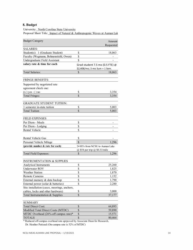
8. Budget
Budget Category
Student(s): 1 (Graduate Student)Faculty (Wegmann, Bohnenstiehl, Owen)Undergraduate Field Assistant
Total Fringes:
GRADUATE STUDENT TUITION:1 semester in-state tuitionTotal Tuition
Per Diem - MealsPer Diem - LodgingRental Vehicle
Rental Vehicle GasPersonal Vehicle Milage
Total Field Expenses:
Analytical InstrumentsUnderwater ROVWeather StationRemote CamerasExternal memory & data backupExternal power (solar & batteries)
Total Instrumentation & Supplies
SUMMARYTotal Direct Cost:Modified Total Direct Costs (MTDC)MTDC Overhead (26%-off campus rate)*TOTALS
59,890$
80,464$
37,177$
1,296$
-$ 1,296$
* Reduced off-campus overhead rate aprpoved by Associate Dean for Research, Dr. Heather Patisaul (On-campus rate is 52% of MTDC)
1,790$
24 RTs from NCSU to Auman Lake @ $54 per trip @ $0.33/mile
2,280$ Site installation (cases, moorings, anchors, cables, locks and other hardware)
1,152$
INSTRUMENTATION & SUPPLIES25,260$ 1,825$ 1,870$
3,000$
64,893$
15,571$
University: North Corolina State UniversityProposal Short Title: Impact of Natural & Anthropogenic Waves at Auman Lak
AmountRequested
Total Salaries: 18,063$
SALARIES:18,063$
-$ -$
salary rate & time for each Grad student 7.5 mo (0.5 FTE) @ $2,408/mo; 3 mo Sum + 1 Sem.
FRINGE BENEFITS:Supported by negotiated rateagreement check one:(x ) yes ( ) no 3,354$
(provide number & rate for each)
3,354$
FIELD EXPENSES-$ -$ -$
5,003$ 5,003$
NCSU-MEAS AUMAN LAKE PROPOSAL – 1/19/2021 15
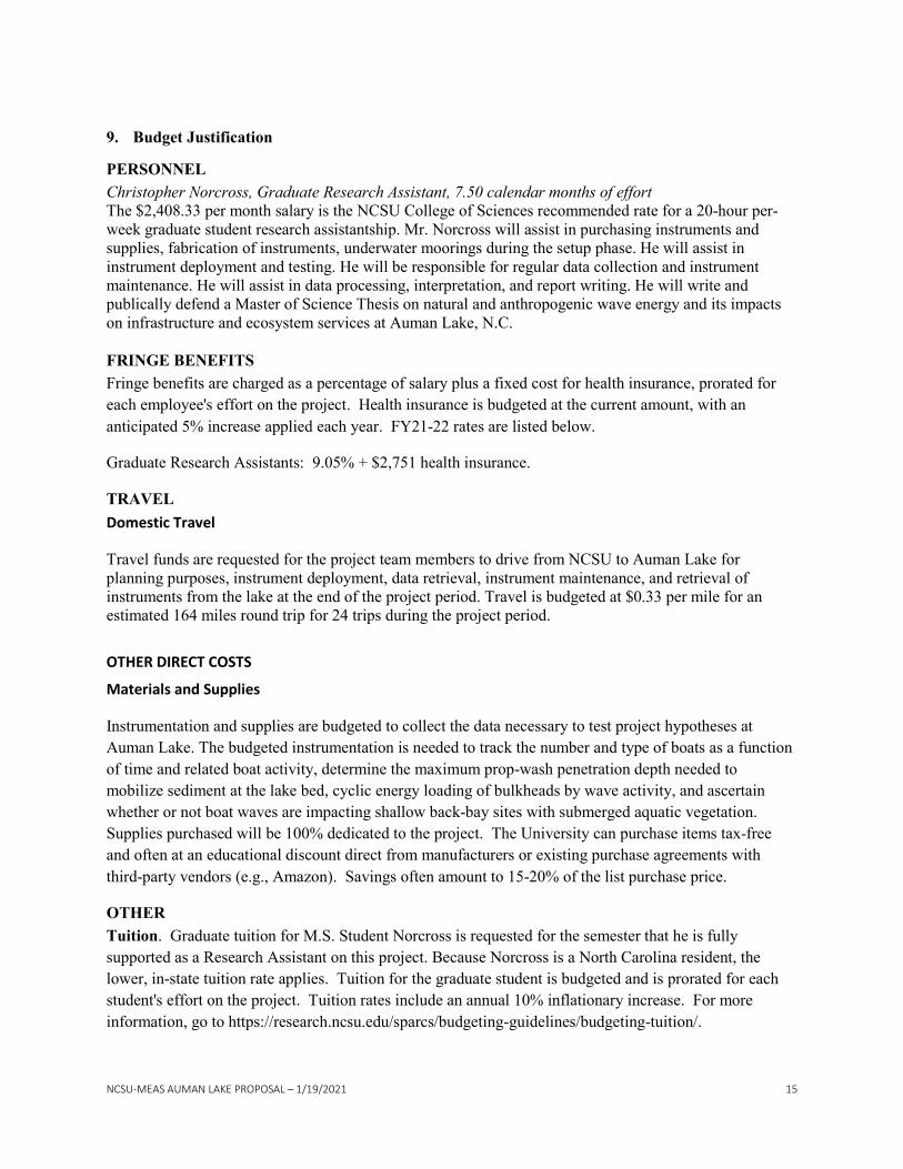
9. Budget Justification
PERSONNEL Christopher Norcross, Graduate Research Assistant, 7.50 calendar months of effort The $2,408.33 per month salary is the NCSU College of Sciences recommended rate for a 20-hour per-week graduate student research assistantship. Mr. Norcross will assist in purchasing instruments and supplies, fabrication of instruments, underwater moorings during the setup phase. He will assist in instrument deployment and testing. He will be responsible for regular data collection and instrument maintenance. He will assist in data processing, interpretation, and report writing. He will write and publically defend a Master of Science Thesis on natural and anthropogenic wave energy and its impacts on infrastructure and ecosystem services at Auman Lake, N.C. FRINGE BENEFITS Fringe benefits are charged as a percentage of salary plus a fixed cost for health insurance, prorated for each employee's effort on the project. Health insurance is budgeted at the current amount, with an anticipated 5% increase applied each year. FY21-22 rates are listed below.
Graduate Research Assistants: 9.05% + $2,751 health insurance.
TRAVEL Domestic Travel
Travel funds are requested for the project team members to drive from NCSU to Auman Lake for planning purposes, instrument deployment, data retrieval, instrument maintenance, and retrieval of instruments from the lake at the end of the project period. Travel is budgeted at $0.33 per mile for an estimated 164 miles round trip for 24 trips during the project period.
OTHER DIRECT COSTS
Materials and Supplies
Instrumentation and supplies are budgeted to collect the data necessary to test project hypotheses at Auman Lake. The budgeted instrumentation is needed to track the number and type of boats as a function of time and related boat activity, determine the maximum prop-wash penetration depth needed to mobilize sediment at the lake bed, cyclic energy loading of bulkheads by wave activity, and ascertain whether or not boat waves are impacting shallow back-bay sites with submerged aquatic vegetation. Supplies purchased will be 100% dedicated to the project. The University can purchase items tax-free and often at an educational discount direct from manufacturers or existing purchase agreements with third-party vendors (e.g., Amazon). Savings often amount to 15-20% of the list purchase price.
OTHER Tuition. Graduate tuition for M.S. Student Norcross is requested for the semester that he is fully supported as a Research Assistant on this project. Because Norcross is a North Carolina resident, the lower, in-state tuition rate applies. Tuition for the graduate student is budgeted and is prorated for each student's effort on the project. Tuition rates include an annual 10% inflationary increase. For more information, go to https://research.ncsu.edu/sparcs/budgeting-guidelines/budgeting-tuition/.
NCSU-MEAS AUMAN LAKE PROPOSAL – 1/19/2021 16
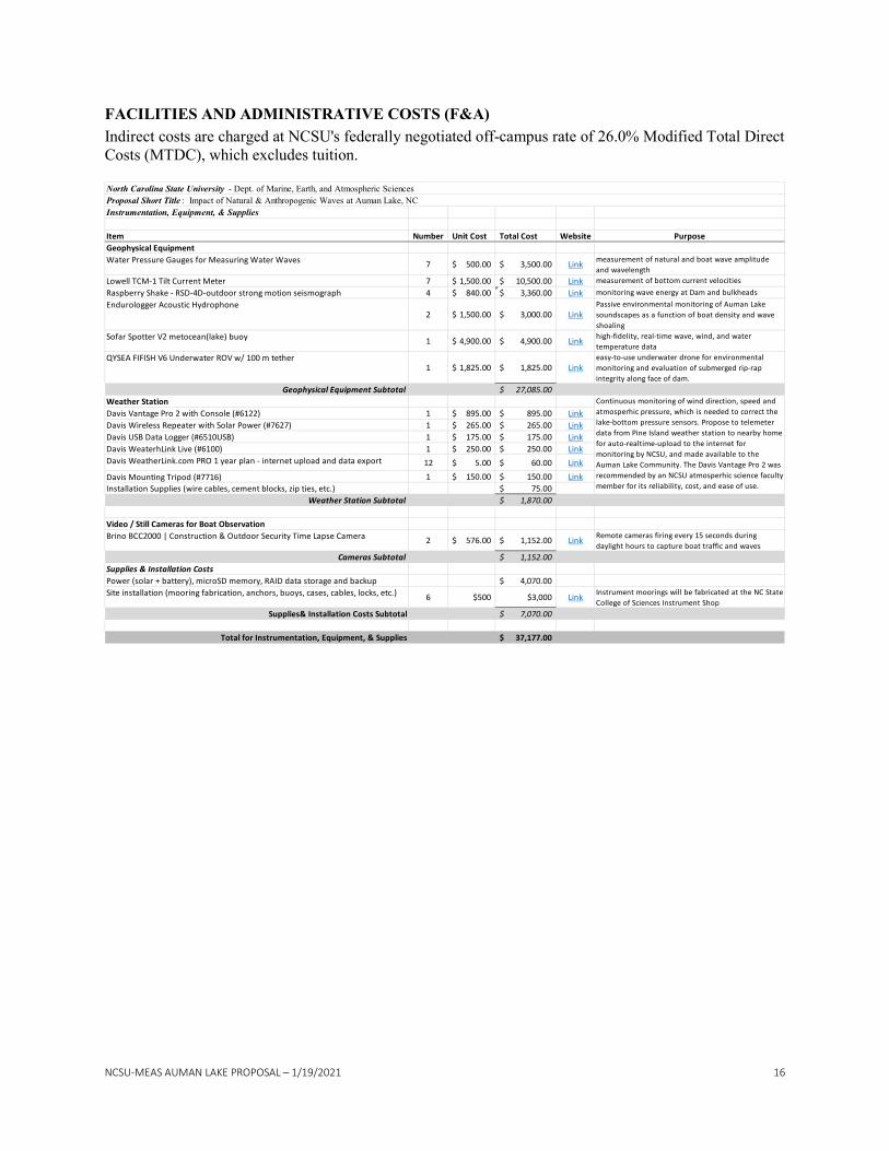
FACILITIES AND ADMINISTRATIVE COSTS (F&A) Indirect costs are charged at NCSU's federally negotiated off-campus rate of 26.0% Modified Total Direct Costs (MTDC), which excludes tuition.
Instrumentation, Equipment, & Supplies
Item Number Unit Cost Total Cost Website PurposeGeophysical EquipmentWater Pressure Gauges for Measuring Water Waves 7 500.00$ 3,500.00$ Link measurement of natural and boat wave amplitude
and wavelengthLowell TCM-1 Tilt Current Meter 7 1,500.00$ 10,500.00$ Link measurement of bottom current velocitiesRaspberry Shake - RSD-4D-outdoor strong motion seismograph 4 840.00$ 3,360.00$ Link monitoring wave energy at Dam and bulkheadsEndurologger Acoustic Hydrophone
2 1,500.00$ 3,000.00$ LinkPassive environmental monitoring of Auman Lake soundscapes as a function of boat density and wave shoaling
Sofar Spotter V2 metocean(lake) buoy 1 4,900.00$ 4,900.00$ Link high-fidelity, real-time wave, wind, and water temperature data
QYSEA FIFISH V6 Underwater ROV w/ 100 m tether1 1,825.00$ 1,825.00$ Link
easy-to-use underwater drone for environmental monitoring and evaluation of submerged rip-rap integrity along face of dam.
Geophysical Equipment Subtotal 27,085.00$ Weather StationDavis Vantage Pro 2 with Console (#6122) 1 895.00$ 895.00$ LinkDavis Wireless Repeater with Solar Power (#7627) 1 265.00$ 265.00$ LinkDavis USB Data Logger (#6510USB) 1 175.00$ 175.00$ LinkDavis WeaterhLink Live (#6100) 1 250.00$ 250.00$ LinkDavis WeatherLink.com PRO 1 year plan - internet upload and data export 12 5.00$ 60.00$ Link
Davis Mounting Tripod (#7716) 1 150.00$ 150.00$ LinkInstallation Supplies (wire cables, cement blocks, zip ties, etc.) 75.00$
Weather Station Subtotal 1,870.00$
Video / Still Cameras for Boat ObservationBrino BCC2000 | Construction & Outdoor Security Time Lapse Camera 2 576.00$ 1,152.00$ Link Remote cameras firing every 15 seconds during
daylight hours to capture boat traffic and wavesCameras Subtotal 1,152.00$
Supplies & Installation CostsPower (solar + battery), microSD memory, RAID data storage and backup 4,070.00$ Site installation (mooring fabrication, anchors, buoys, cases, cables, locks, etc.) 6 $500 $3,000 Link Instrument moorings will be fabricated at the NC State
College of Sciences Instrument ShopSupplies& Installation Costs Subtotal 7,070.00$
Total for Instrumentation, Equipment, & Supplies 37,177.00$
North Carolina State University - Dept. of Marine, Earth, and Atmospheric SciencesProposal Short Title : Impact of Natural & Anthropogenic Waves at Auman Lake, NC
Continuous monitoring of wind direction, speed and atmosperhic pressure, which is needed to correct the lake-bottom pressure sensors. Propose to telemeter data from Pine Island weather station to nearby home for auto-realtime-upload to the internet for monitoring by NCSU, and made available to the Auman Lake Community. The Davis Vantage Pro 2 was recommended by an NCSU atmosperhic science faculty member for its reliability, cost, and ease of use.
NCSU-MEAS AUMAN LAKE PROPOSAL – 1/19/2021 17
10. Cited References
Adams, P.N., Anderson, R.S., and Revenaugh, J., 2002, Microseismic measurement of wave-energy delivery to a rocky coast: Geology, v. 30, p. 895–898.
Bagnold, R.A., 1940, Beach formation by waves: Some model experiments in a wave tank: Journal of the Institution of Civil Engineers, v. 15, p. 27–52.
Bilkovic, D.M., Mitchell, M.M., Davis, J., Herman, J., Andrews, E., King, A., Mason, P., Tahvildari, N., Davis, J., and Dixon, R.L., 2019, Defining boat wake impacts on shoreline stability toward management and policy solutions: Ocean & Coastal Management, v. 182, p. 104945, doi:https://doi.org/10.1016/j.ocecoaman.2019.104945.
Bohnenstiehl, D.R., Lyon, R.P., Caretti, O.N., Ricci, S.W., and Eggleston, D.B., 2018, Investigating the utility of ecoacoustic metrics in marine soundscapes: J. Ecoacoustics, v. 2, p. R1156L.
Chrzastowski, M.J., 1989, Sidescan sonar examination of deteriorated revetments and bulkheads along Chicago’s lake front, in Coastal Zone’89: Proceedings of the Sixth Symposium on Coastal and Ocean Management, v. 4, p. 3931–3944.
Fredsøe, J., and Deigaard, R., 1992, Mechanics of coastal sediment transport: World Scientific, v. 3.
Haggard, B.E., Moore Jr, P.A., and DeLaune, P.B., 2005, Phosphorus flux from bottom sediments in Lake Eucha, Oklahoma: Journal of environmental quality, v. 34, p. 724–728.
Hofmann, H., Lorke, A., and Peeters, F., 2008, The relative importance of wind and ship waves in the littoral zone of a large lake: Limnology and Oceanography, v. 53, p. 368–380.
Hong, J.-H., Chiew, Y.-M., and Cheng, N.-S., 2013, Scour caused by a propeller jet: Journal of Hydraulic Engineering, v. 139, p. 1003–1012.
Kangur, K., Ginter, K., Kangur, P., Kangur, A., Nõges, P., and Laas, A., 2016, Changes in water temperature and chemistry preceding a massive kill of bottom-dwelling fish: an analysis of high-frequency buoy data of shallow Lake Võrtsjärv (Estonia): Inland Waters, v. 6, p. 535–542.
Kim, L.-H., Choi, E., and Stenstrom, M.K., 2003, Sediment characteristics, phosphorus types and phosphorus release rates between river and lake sediments: Chemosphere, v. 50, p. 53–61.
Lowell, N.S., Walsh, D.R., and Pohlman, J.W., 2015, A Comparison of tilt current meters and an acoustic doppler current meter in Vineyard Sound, Massachusetts, in 2015 IEEE/OES Eleveth Current, Waves and Turbulence Measurement (CWTM), IEEE, p. 1–7.
Pollara, A., Sutin, A., and Salloum, H., 2017, Passive acoustic methods of small boat detection, tracking and classification, in 2017 IEEE International Symposium on Technologies for Homeland Security (HST), IEEE, p. 1–6.
NCSU-MEAS AUMAN LAKE PROPOSAL – 1/19/2021 18
Powell, A., 1958, On the fatigue failure of structures due to vibrations excited by random pressure fields: The Journal of the Acoustical Society of America, v. 30, p. 1130–1135.
Radermacher, M., Thackeray, Z.H., De Schipper, M.A., Gordon, L., Chrystal, C., Leuci, R., and Reniers, A., 2015, Tilt current meter array: Field validation, in E-proceedings of the 36th IAHR World Congress, The Hague, the Netherlands, 28 June-3 July 2015, IAHR.
Riungu, G.K., Hallo, J.C., Backman, K.F., Brownlee, M., Beeco, J.A., and Larson, L.R., 2020, Water-based recreation management: a normative approach to reviewing boating thresholds: Lake and Reservoir Management, p. 1–16.
Sumer, B.M., 2002, The mechanics of scour in the marine environment: World Scientific.
Temple, N.A., Webb, B.M., Sparks, E.L., and Linhoss, A.C., 2020, Low-Cost Pressure Gauges for Measuring Water Waves: Journal of Coastal Research, v. 36, p. 661–667.
Voli, M.T., Wegmann, K.W., Bohnenstiehl, D.R., Leithold, E., Osburn, C.L., and Polyakov, V., 2013, Fingerprinting the sources of suspended sediment delivery to a large municipal drinking water reservoir: Falls Lake, Neuse River, North Carolina, USA: Journal of Soils and Sediments, v. 13, doi:10.1007/s11368-013-0758-3.
Yang, X., Sun, H., Fu, K., Yang, J., Sun, X., Yan, M., and Guo, Z., 2018, Automatic ship detection in remote sensing images from google earth of complex scenes based on multiscale rotation dense feature pyramid networks: Remote Sensing, v. 10, p. 132.