Embed Size (px)
Citation preview
A Profile of Eastern Ontario
May 2013
Prepared by: Sarah Minnes and David J.A. Douglas
School of Environmental Design and Rural Development University of Guelph
Eastern Ontario Profile
Table of Contents Introduction ....................................................................................................................... 1 Location ............................................................................................................................ 1 Brief History ...................................................................................................................... 2 Physiographic Features .................................................................................................... 3 Demographic Profile ......................................................................................................... 6 Employment Characteristics ............................................................................................. 9 Government .................................................................................................................... 14 Other Regional Actors .................................................................................................... 15 Regional Collaborations and Interdependencies ............................................................ 16 Transportation and Communication Networks................................................................ 17 Summary ........................................................................................................................ 18 References ..................................................................................................................... 19
1
Introduction The purpose of this document is to provide a summary of the principal characteristics of one of the case study regions in the project - Canadian Regional Development: A Critical Review of Theory, Practice and Potentials. The project’s primary intention was to critically examine the evidence of what has been called “New Regionalism” in the regional development policies and practices in Canada. The project involved a very substantial field research component of some five months interviewing throughout Eastern Ontario, a major literature review, and other activities. This document provides a profile of the region, primarily from secondary sources (e.g. Statistics Canada, Province of Ontario, local planning documents). It is not part of the project’s analysis and is designed to provide an informative resource piece on the development context and conditions in Eastern Ontario.
This document was prepared by Sarah Minnes, M.Sc (Planning) with the assistance of David J.A. Douglas, Professor Emeritus, Rural Planning and Development, University of Guelph.
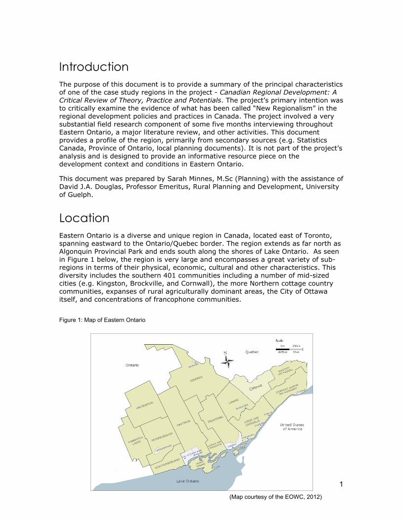
Location Eastern Ontario is a diverse and unique region in Canada, located east of Toronto, spanning eastward to the Ontario/Quebec border. The region extends as far north as Algonquin Provincial Park and ends south along the shores of Lake Ontario. As seen in Figure 1 below, the region is very large and encompasses a great variety of sub-regions in terms of their physical, economic, cultural and other characteristics. This diversity includes the southern 401 communities including a number of mid-sized cities (e.g. Kingston, Brockville, and Cornwall), the more Northern cottage country communities, expanses of rural agriculturally dominant areas, the City of Ottawa itself, and concentrations of francophone communities.
Figure 1: Map of Eastern Ontario
(Map courtesy of the EOWC, 2012)
2
Brief History Eastern Ontario has a rich and culturally diverse history. Long before the first European explorers and settlers inhabited the area (late 17th to 19th centuries) many First Nation communities settled, hunted, fished and traveled the waterways of the region. These populations include the First Nation communities of Akwesasne, Ardoch Algonquin, Golden Lake, Alderville, Hiawatha, Curve Lake , Scugog Lake and the Mohawks of the Bay of Quinte (KNET, 2012). As early as the 1600’s explorer Samuel de Champlain and various fur traders traveled through the Ottawa River from Quebec in their quests through to the Great Lakes and the Georgian Bay area (Canada History, 2012). Due to the influence of the founding French explorers in the far-east parts of Eastern Ontario, the City of Ottawa, the United Counties of Prescott and Russell, the United Counties of Stormont, Dundas and Glengarry, and parts of Renfrew County still have substantial francophone communities.
In the late 1700’s Britain took control of both Upper and Lower Canada from France as result of the Seven Year War which ended in the signing of the Treaty of Paris in 1763 (Lanark County, 2012). From 1776-1783, the American Revolution took place which gave rise to increased migration to Canada by colonists in America who wanted to remain loyal to the British crown, later to be called the United Empire Loyalists (Kingston Historical Society, 2003). These loyalists concentrated in Eastern Ontario on the north shore of the St. Lawrence River, near Kingston and the Bay of Quinte area located in Prince Edward County near Belleville (Watson, 2011). Following the War of 1812 large amounts of Scottish Highlanders and Irish Catholics also settled in the region, mainly near the present day Ottawa area. The War of 1812 also brought about the importance of a secure waterway that did not border on the U.S. In 1826, construction began on the Rideau Canal between Kingston and Ottawa (Lanark County, 2012). The Rideau Canal, now a major tourism resource, is recognized as a UNESCO World Heritage site (UNESCO World Heritage Centre, 2012).
During the 19th century agriculture was largely depended on as a source of revenue. In particular in the lower St. Lawrence area, agriculture was booming as there was a grain surplus which was exported to Quebec and overseas (The Canadian Encyclopedia, 2012). Throughout most of the 19th century Eastern Ontario experienced a thriving economy that mainly consisted of milling, lumbering and agriculture. Furthermore, the first mine in Ontario was located in Marmora, Hastings County, which was established in the 1820’s (The first mine in Ontario, 2012). In 1841, Kingston became the first capital of the new province of Upper Canada, which united Canada East (now Quebec) and Canada West (now Ontario) (Kingston Historical Society, 2003). In 1867, Kingston resident John A. Macdonald was appointed as the first Prime Minister of the newly formed Dominion of Canada (Kingston Historical Society, 2003). Post-confederation, during the latter half of the late 19th century and the early 20th century, rural populations in the area began to decline as did the lumber industry. Many farmers migrated to western Canada in hopes of more fertile land and Ontario began importing more wheat from western Canada, while increasing its output of oats and other fodder crops (Lanark County, 2012). The decline in rural populations and continuing international immigration to Canada led to urbanization and population increases in cities in the region such as Ottawa, Peterborough and Kingston (The Canadian Encyclopedia, 2012).
In 1914, World War I began and in 1918 the war ended creating an economy that boomed and then went bust with the stock market crash of 1929. The stock market

3
crash precipitated the beginning of the Great Depression, which ended with the onset of World War II in 1939. After World War II Eastern Ontario, Ontario as a whole and Canada prospered experiencing increased populations due to a “baby boom” as well as increased immigration (Ontario Government, 2011).
Urbanization and industrialization continued from the 1950’s on in Eastern Ontario with the continued growth of the manufacturing economy, notably the branch plant economy, and the construction of the 401 highway (Kingston Historical Society, 2003). Emerging urban centres such as Peterborough and Kingston experienced rapid population growth with the attraction of major companies such as the Quaker Oats Company and General Electric in Peterborough, the Hershey Co. factory in Smith Falls and Du Pont (then known as Canadian Industries Ltd) in Kingston (Kingston Historical Society, 2003). Furthermore, a thriving mining economy was experienced in the more northern locations of Eastern Ontario (e.g. Marmora) with the discovery of valuable minerals such as magnetite ore (Ontario Rural Routes, 2011). The creamery sector was also prominent during this time with the presence of creameries such as the Kawartha Dairy Company.
From the 1950’s (and in some cases far before then) to the present day Eastern Ontario has continued to offer a multitude of educational opportunities, with several prominent universities and colleges such as Trent University and Sir Sanford Fleming in Peterborough, Queen’s University and St. Lawrence College in Kingston, Carleton University, University of Ottawa and Algonquin College in Ottawa, and Loyalist College in Belleville. These educational opportunities have provided an increase in education and literacy levels in the region, directing the growing labour force in the area towards more technical occupations. Starting in the 1970’s, many universities and colleges in Eastern Ontario began offering specialized technological studies in subjects such as engineering, agriculture and telecommunications (The Canadian Encyclopedia, 2012). In the 1970’s, specialization in new technologies contributed to the diversification of the City of Ottawa’s economy beyond Federal civil services into high technology with companies such as Nortel and Mitel offering telecommunication products and services.
Today, agriculture is still a very important part of Eastern Ontario’s economy, especially in the more far-east Counties (e.g. the United Counties of Prescott and Russell and the United Counties of Stormont, Dundas and Glengarry). The lumber industry is still present in the more Northern areas of the region (e.g. Renfrew County). The historical sites of Kingston and other areas throughout the region, the Parliament buildings and other national treasures in the City of Ottawa and the beautiful lakes and countryside of the entire region makes Eastern Ontario an ideal place for tourism, cottaging, family recreation and vacationing. Furthermore, the educational facilities and the recent push for broadband and other telecommuting services are making the area very attractive to former central Ontario residents as well as industries.
Physiographic Features Eastern Ontario has a geographic area of 49,000 km2 , extending almost 450km’s west to east and over 300km’s north to south (EOWC, 2007). This large region holds various sub regions such as areas predominated by the Canadian Shield and numerous small lakes, the Lake Ontario lakeshore area, the St. Lawrence Seaway, the Ottawa Valley and the presence in some locations of primarily agricultural areas.

4
In fact, according to Canada’s Land Inventory (CLI) much of the southern part of Eastern Ontario is well suited to agricultural purposes with the majority of soil coverage being in soil classes1-3, providing a diversity of opportunities for agricultural production (EOWC, 2007). The more northern soils of the region are typically forested lands, as they hold predominately soil classes 4-6, asides from a small pocket of class 3 soils located in the eastern part of Renfrew County (EOWC, 2007).
The region contains two main forest regions as defined by the Ministry of Natural Resources: the Great Lakes St-Lawrence forests region located in the more northern areas of Eastern Ontario and the Deciduous forest region located in the southern areas of the region (MNR, 2012). The Great Lakes St-Lawrence forest region is characterized by mainly coniferous trees such as eastern white pine, red pine, eastern hemlock and white cedar, mixed with deciduous species, such as yellow birch, sugar and red maples, basswood and red oak. This type of forest also contains many species of fungi, ferns, mosses and shrubs. Due to the fact that the Boreal forest region borders the Great Lakes St-Lawrence forests region, some species found in the Boreal forest, such as white and black spruce, jack pine, aspen and white birch also exist in the Great Lakes St-Lawrence forests (MNR, 2012). The Deciduous forest region has similar species of trees and shrubs as the Great Lakes-St. Lawrence forest. This region also contains region specific species such as black walnut, butternut, tulip, magnolia, black gum, many types of oaks, hickories, sassafras and red bud species (MNR, 2012). Along with the lumber industry the mining industry has also been part of Eastern Ontario’s traditional economy, with the Canadian Shield area of Eastern Ontario being one of the first areas in Ontario to be mined (Sherwin, 2003). Traditional mined minerals include iron, gold, graphite, apatite (calcium phosphate), phlogopite (white mica), vermiculite and feldspar (Sherwin, 2003).
Between the iconic Canadian Shield, the Boreal Forest and the extensive St. Lawrence Lowlands is a rich and diverse ecotone or regime of transition zones. Stretching in a wide sweeping arc, averaging 40 kms in width, from the Parry Sound and Couchiching areas to the west of Eastern Ontario to the Quebec border to the East, this unique physiographic and ecological zone runs through the centre of the region itself astride Highway 7 all the way to Tweed and environs on to Perth and the Ottawa Valley. Less rugged than the near north, but undulating with extensive tracts of ridged and flat bare rock (granites and limestone) and disparate pockets of thin soils and scattered farmlands and woodlots, this large transition sub region contains flora and fauna found in the abutting sub regions to the north and south, as well as a diversity of unique characteristics. Here northern and southern ranges of a variety of flora and fauna intermingle in a distinctive transitional landscape.
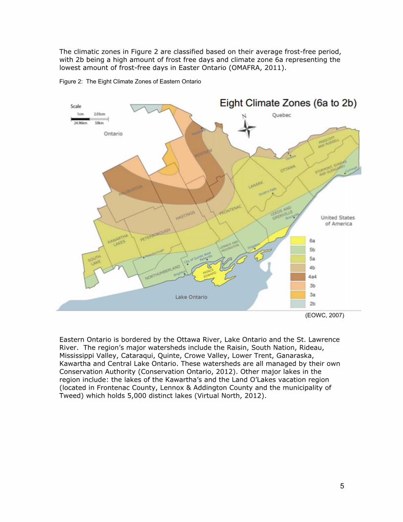
Eastern Ontario ranges greatly in its climate. In the northern parts of the region the temperature can range from -30°C in the winter to +38°C in the summer. In places closer to the St. Lawrence Seaway, such as Prince Edward County, a milder winter is experienced, with highs of 10°C (EOWC, 2007). The southern portion of Eastern Ontario experiences the “lake effect” due to the presence of Lake Ontario, which causes a humid continental climate during the summer and greater precipitation during the winter, similar to South Western and Central Ontario (EOWC, 2007). Eastern Ontario’s 8 different climatic zones makes for interesting industries, such as the wine country of Prince Edward County and the forestry sector in the more northern Renfrew County as well as winter tourism in both Haliburton County and Renfrew County (EOWC, 2007). The 8 climatic zones are shown below in Figure 2.
5
The climatic zones in Figure 2 are classified based on their average frost-free period, with 2b being a high amount of frost free days and climate zone 6a representing the lowest amount of frost-free days in Easter Ontario (OMAFRA, 2011).
Figure 2: The Eight Climate Zones of Eastern Ontario
(EOWC, 2007) Eastern Ontario is bordered by the Ottawa River, Lake Ontario and the St. Lawrence River. The region’s major watersheds include the Raisin, South Nation, Rideau, Mississippi Valley, Cataraqui, Quinte, Crowe Valley, Lower Trent, Ganaraska, Kawartha and Central Lake Ontario. These watersheds are all managed by their own Conservation Authority (Conservation Ontario, 2012). Other major lakes in the region include: the lakes of the Kawartha’s and the Land O’Lakes vacation region (located in Frontenac County, Lennox & Addington County and the municipality of Tweed) which holds 5,000 distinct lakes (Virtual North, 2012).

6
Figure 3: Map of Conservation Authorities in Eastern Ontario
Eastern Ontario is home to several Provincial parks containing treasures such as the 1000 Islands, the Ottawa River and the southern tip of Algonquin Provincial Park (Ontario Parks, 2012). The historic Rideau Canal Waterway, which was deemed a UNESCO world heritage site, is also located in Eastern Ontario (UNESCO World Heritage Centre, 2012). Due to the geographical extent of Eastern Ontario, as mentioned, there is a significant amount of ecological overlap between southern forest elements and northern boreal and mixed forest systems. As a result, it is one of the most biologically diverse areas in Ontario containing a large number of lakes and a diverse system of wetland types, including swamps, marshes, beaver ponds and bogs (TIWLT, n.d). These varied habitats create breeding grounds for unique wildlife, such as Ontario’s only lizard, the five-lined skink, and other globally significant species such as the common musk turtle, the least bittern, the cerulean warbler, the blunt-lobed woodsia (a type of fern) and the gray ratsnake (NCC, 2012).
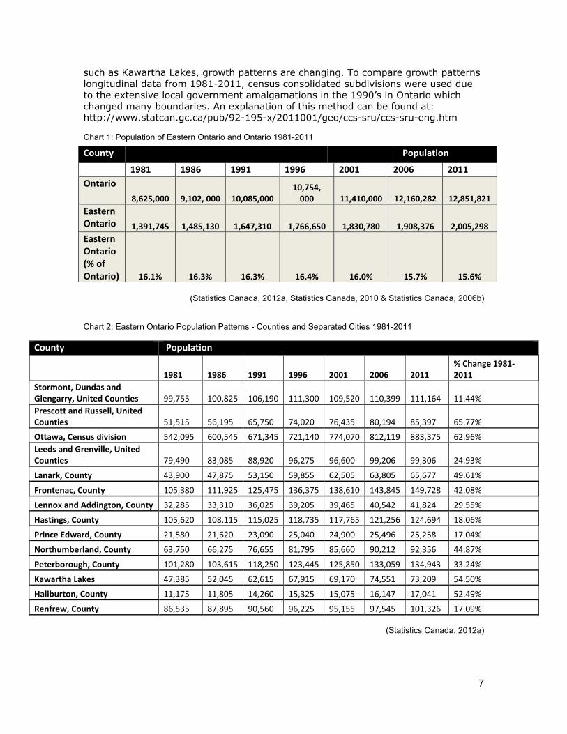
Demographic Profile Eastern Ontario is home to nearly 2 million people. In total the region represents approximately15% of Ontario’s total population (EOWC, 2007). Below in Chart 1, 2 and 3, the total population of Eastern Ontario compared to Ontario, as well as a breakdown of each County (including separated cities) and the populations of each major city in the region are displayed. As shown, both urban and rural areas are experiencing positive growth patterns. Ottawa as the nation’s capital is still the major population center and place of growth. However, as exemplified by counties
(Conservation Ontario, 2012)
7
such as Kawartha Lakes, growth patterns are changing. To compare growth patterns longitudinal data from 1981-2011, census consolidated subdivisions were used due to the extensive local government amalgamations in the 1990’s in Ontario which changed many boundaries. An explanation of this method can be found at: http://www.statcan.gc.ca/pub/92-195-x/2011001/geo/ccs-sru/ccs-sru-eng.htm
Chart 1: Population of Eastern Ontario and Ontario 1981-2011
(Statistics Canada, 2012a, Statistics Canada, 2010 & Statistics Canada, 2006b)
Chart 2: Eastern Ontario Population Patterns - Counties and Separated Cities 1981-2011
County Population
1981 1986 1991 1996 2001 2006 2011 % Change 1981-‐2011
Stormont, Dundas and Glengarry, United Counties 99,755 100,825 106,190 111,300 109,520 110,399 111,164 11.44% Prescott and Russell, United Counties 51,515 56,195 65,750 74,020 76,435 80,194 85,397 65.77%
Ottawa, Census division 542,095 600,545 671,345 721,140 774,070 812,119 883,375 62.96% Leeds and Grenville, United Counties 79,490 83,085 88,920 96,275 96,600 99,206 99,306 24.93%
Lanark, County 43,900 47,875 53,150 59,855 62,505 63,805 65,677 49.61%
Frontenac, County 105,380 111,925 125,475 136,375 138,610 143,845 149,728 42.08%
Lennox and Addington, County 32,285 33,310 36,025 39,205 39,465 40,542 41,824 29.55%
Hastings, County 105,620 108,115 115,025 118,735 117,765 121,256 124,694 18.06%
Prince Edward, County 21,580 21,620 23,090 25,040 24,900 25,496 25,258 17.04%
Northumberland, County 63,750 66,275 76,655 81,795 85,660 90,212 92,356 44.87%
Peterborough, County 101,280 103,615 118,250 123,445 125,850 133,059 134,943 33.24%
Kawartha Lakes 47,385 52,045 62,615 67,915 69,170 74,551 73,209 54.50%
Haliburton, County 11,175 11,805 14,260 15,325 15,075 16,147 17,041 52.49%
Renfrew, County 86,535 87,895 90,560 96,225 95,155 97,545 101,326 17.09%
(Statistics Canada, 2012a)
County Population
1981 1986 1991 1996 2001 2006 2011 Ontario
8,625,000 9,102, 000 10,085,000 10,754, 000 11,410,000 12,160,282 12,851,821
Eastern Ontario 1,391,745 1,485,130 1,647,310 1,766,650 1,830,780 1,908,376 2,005,298 Eastern Ontario (% of Ontario) 16.1% 16.3% 16.3% 16.4% 16.0% 15.7% 15.6%
8
Chart 3: Eastern Ontario City Population Profile- 1996-2011
*1981-1991 stats not included due to amalgamation and boundary changes during those years
(Statistics Canada 2006b, Statistics Canada, 2012b)
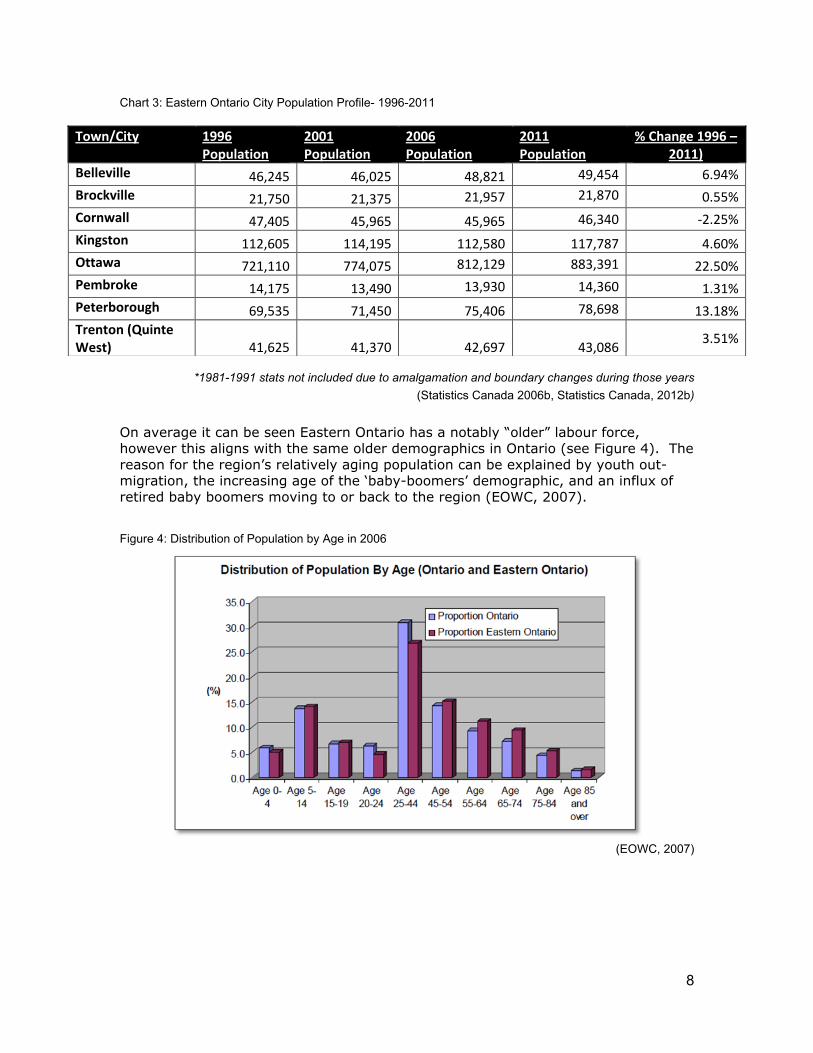
On average it can be seen Eastern Ontario has a notably “older” labour force, however this aligns with the same older demographics in Ontario (see Figure 4). The reason for the region’s relatively aging population can be explained by youth out-migration, the increasing age of the ‘baby-boomers’ demographic, and an influx of retired baby boomers moving to or back to the region (EOWC, 2007).
Figure 4: Distribution of Population by Age in 2006
(EOWC, 2007)
Town/City 1996 Population
2001 Population
2006 Population
2011 Population
% Change 1996 – 2011)
Belleville 46,245 46,025 48,821 49,454 6.94% Brockville 21,750 21,375 21,957 21,870 0.55% Cornwall 47,405 45,965 45,965 46,340 -‐2.25% Kingston 112,605 114,195 112,580 117,787 4.60% Ottawa 721,110 774,075 812,129 883,391 22.50% Pembroke 14,175 13,490 13,930 14,360 1.31% Peterborough 69,535 71,450 75,406 78,698 13.18% Trenton (Quinte West) 41,625 41,370 42,697 43,086
3.51%
9
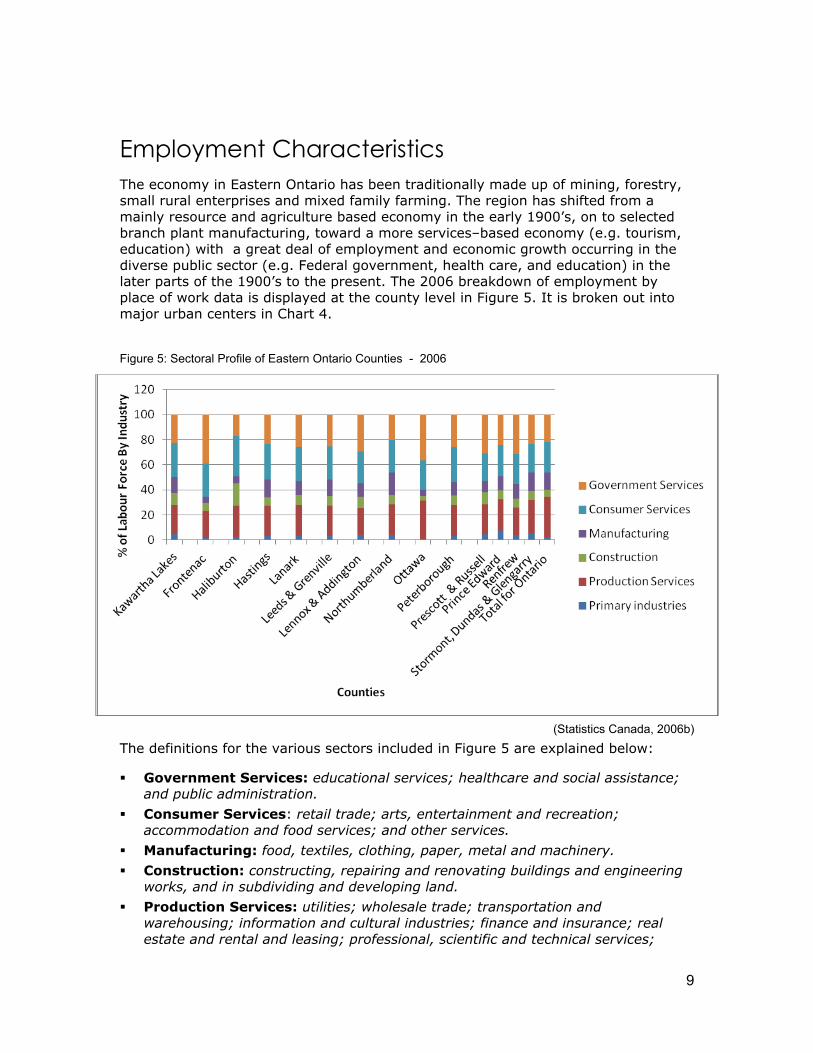
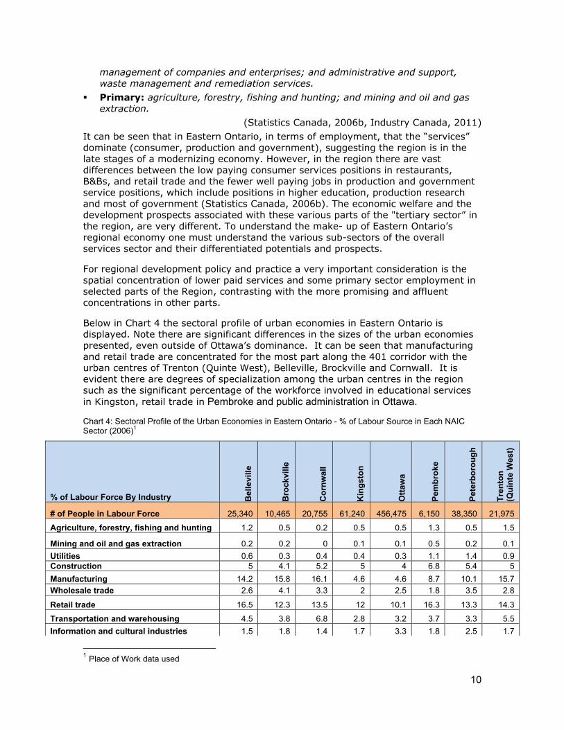
Employment Characteristics The economy in Eastern Ontario has been traditionally made up of mining, forestry, small rural enterprises and mixed family farming. The region has shifted from a mainly resource and agriculture based economy in the early 1900’s, on to selected branch plant manufacturing, toward a more services–based economy (e.g. tourism, education) with a great deal of employment and economic growth occurring in the diverse public sector (e.g. Federal government, health care, and education) in the later parts of the 1900’s to the present. The 2006 breakdown of employment by place of work data is displayed at the county level in Figure 5. It is broken out into major urban centers in Chart 4.
Figure 5: Sectoral Profile of Eastern Ontario Counties - 2006
(Statistics Canada, 2006b)
The definitions for the various sectors included in Figure 5 are explained below:
Government Services: educational services; healthcare and social assistance; and public administration.
Consumer Services: retail trade; arts, entertainment and recreation; accommodation and food services; and other services.
Manufacturing: food, textiles, clothing, paper, metal and machinery. Construction: constructing, repairing and renovating buildings and engineering
works, and in subdividing and developing land. Production Services: utilities; wholesale trade; transportation and
warehousing; information and cultural industries; finance and insurance; real estate and rental and leasing; professional, scientific and technical services;
10
management of companies and enterprises; and administrative and support, waste management and remediation services.
Primary: agriculture, forestry, fishing and hunting; and mining and oil and gas extraction.
(Statistics Canada, 2006b, Industry Canada, 2011) It can be seen that in Eastern Ontario, in terms of employment, that the “services” dominate (consumer, production and government), suggesting the region is in the late stages of a modernizing economy. However, in the region there are vast differences between the low paying consumer services positions in restaurants, B&Bs, and retail trade and the fewer well paying jobs in production and government service positions, which include positions in higher education, production research and most of government (Statistics Canada, 2006b). The economic welfare and the development prospects associated with these various parts of the "tertiary sector” in the region, are very different. To understand the make- up of Eastern Ontario’s regional economy one must understand the various sub-sectors of the overall services sector and their differentiated potentials and prospects.
For regional development policy and practice a very important consideration is the spatial concentration of lower paid services and some primary sector employment in selected parts of the Region, contrasting with the more promising and affluent concentrations in other parts.
Below in Chart 4 the sectoral profile of urban economies in Eastern Ontario is displayed. Note there are significant differences in the sizes of the urban economies presented, even outside of Ottawa’s dominance. It can be seen that manufacturing and retail trade are concentrated for the most part along the 401 corridor with the urban centres of Trenton (Quinte West), Belleville, Brockville and Cornwall. It is evident there are degrees of specialization among the urban centres in the region such as the significant percentage of the workforce involved in educational services in Kingston, retail trade in Pembroke and public administration in Ottawa.
Chart 4: Sectoral Profile of the Urban Economies in Eastern Ontario - % of Labour Source in Each NAIC Sector (2006)1
1 Place of Work data used
% of Labour Force By Industry Bel
levi
lle
Bro
ckvi
lle
Cor
nwal
l
Kin
gsto
n
Otta
wa
Pem
brok
e
Pete
rbor
ough
Tren
ton
(Qui
nte
Wes
t) # of People in Labour Force 25,340 10,465 20,755 61,240 456,475 6,150 38,350 21,975
Agriculture, forestry, fishing and hunting 1.2 0.5 0.2 0.5 0.5 1.3 0.5 1.5
Mining and oil and gas extraction 0.2 0.2 0 0.1 0.1 0.5 0.2 0.1 Utilities 0.6 0.3 0.4 0.4 0.3 1.1 1.4 0.9 Construction 5 4.1 5.2 5 4 6.8 5.4 5 Manufacturing 14.2 15.8 16.1 4.6 4.6 8.7 10.1 15.7 Wholesale trade 2.6 4.1 3.3 2 2.5 1.8 3.5 2.8
Retail trade 16.5 12.3 13.5 12 10.1 16.3 13.3 14.3
Transportation and warehousing 4.5 3.8 6.8 2.8 3.2 3.7 3.3 5.5 Information and cultural industries 1.5 1.8 1.4 1.7 3.3 1.8 2.5 1.7
11
(Statistics Canada, 2006b)
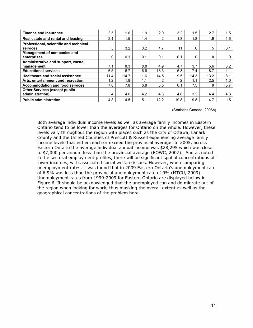
Both average individual income levels as well as average family incomes in Eastern Ontario tend to be lower than the averages for Ontario on the whole. However, these levels vary throughout the region with places such as the City of Ottawa, Lanark County and the United Counties of Prescott & Russell experiencing average family income levels that either reach or exceed the provincial average. In 2005, across Eastern Ontario the average individual annual income was $28,295 which was close to $7,000 per annum less than the provincial average (EOWC, 2007). And as noted in the sectoral employment profiles, there will be significant spatial concentrations of lower incomes, with associated social welfare issues. However, when comparing unemployment rates, it was found that in 2009 Eastern Ontario’s unemployment rate of 6.9% was less than the provincial unemployment rate of 9% (MTCU, 2009). Unemployment rates from 1999-2009 for Eastern Ontario are displayed below in Figure 6. It should be acknowledged that the unemployed can and do migrate out of the region when looking for work, thus masking the overall extent as well as the geographical concentrations of the problem here.
Finance and insurance 2.5 1.6 1.9 2.9 3.2 1.5 2.7 1.5 Real estate and rental and leasing 2.1 1.5 1.4 2 1.8 1.8 1.9 1.6 Professional, scientific and technical services 5 3.2 3.2 4.7 11 6 5 3.1 Management of companies and enterprises 0 0.1 0.1 0.1 0.1 0 0 0 Administrative and support, waste management 7.1 8.3 8.8 4.9 4.7 3.7 5.6 6.2 Educational services 6.5 6.7 6.6 13.3 6.8 7.4 8.7 4.1 Healthcare and social assistance 11.4 14.7 11.6 14.5 9.5 14.3 13.2 8.1 Arts, entertainment and recreation 1.2 1.9 1.1 2 2 1.1 2.5 1.6 Accommodation and food services 7.8 7.8 6.8 8.5 6.1 7.5 9 5.7 Other Services (except public administration) 4 4.6 4.2 4.3 4.8 3.2 4.4 4.3 Public administration 4.8 4.5 5.1 12.2 19.8 9.8 4.7 15
12
Figure 6: Unemployment Rate, Eastern Ontario and Ontario, 1999-2009
(MTCU, 2009)
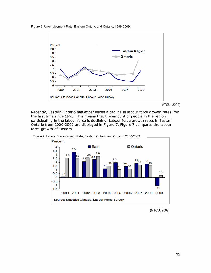
Recently, Eastern Ontario has experienced a decline in labour force growth rates, for the first time since 1996. This means that the amount of people in the region participating in the labour force is declining. Labour force growth rates in Eastern Ontario from 2000-2009 are displayed in Figure 7. Figure 7 compares the labour force growth of Eastern
Figure 7: Labour Force Growth Rate, Eastern Ontario and Ontario, 2000-2009
(MTCU, 2009)
13
Ontario to Ontario as a whole. In 2009, Eastern Ontario’s labour force went down -1.1% (a loss of 11,700 people), in comparison to the labour force growth rate for Ontario which grew by +0.3% (an estimated 20,600 people). More recent Census data is needed to evaluate if this decline in labour force rates is a persisting problem in the region.
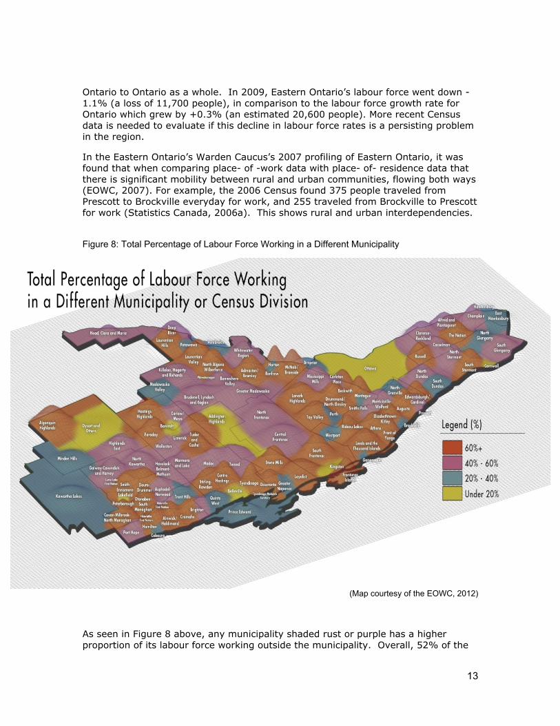
In the Eastern Ontario’s Warden Caucus’s 2007 profiling of Eastern Ontario, it was found that when comparing place- of -work data with place- of- residence data that there is significant mobility between rural and urban communities, flowing both ways (EOWC, 2007). For example, the 2006 Census found 375 people traveled from Prescott to Brockville everyday for work, and 255 traveled from Brockville to Prescott for work (Statistics Canada, 2006a). This shows rural and urban interdependencies.
Figure 8: Total Percentage of Labour Force Working in a Different Municipality
(Map courtesy of the EOWC, 2012)
As seen in Figure 8 above, any municipality shaded rust or purple has a higher proportion of its labour force working outside the municipality. Overall, 52% of the
14
labour force in rural Eastern Ontario works in a different municipality or census division than where they live. The region differs from the provincial average of the labour force working in different municipalities, which is 32.6% (Statistics Canada, 2006a). Major urban centres such as Kingston, Cornwall, Belleville, Peterborough and Ottawa still remain relatively self- contained, with fewer than 20% of the population working in a different municipality. However, there are also self-contained economic (employment) areas in more rural areas such as the Municipality of Dysart, the Township of Addington Highlands, Prince Edward County, Madawaska Valley, Pembroke, Westport, Perth and North Grenville (EOWC, 2012). Generally, even though there is plenty of cross-commuting in the region, there are also urban and rural areas that are relatively self- contained in terms of labour market dynamics. This highlights the complexity and diversity in the regional economy.
Government Eastern Ontario is made up of lower, upper and single tier municipal governments. The upper tier counties that make up the region are: Kawartha Lakes; Peterborough; Northumberland; Haliburton; Hastings; Prince Edward; Renfrew; Frontenac; Lanark; Leeds & Grenville; City of Ottawa; Prescott and Russel; Lennox & Addington; and Stormont, Dundas & Glengary (see Figure 1, above) (EOWC, 2007). The Eastern Ontario Warden’s Caucus (EOWC), though not a formal level of government, has been very influential in the region over the last decade. Made up of 11 Eastern Ontario Counties, this group has created a unified voice for Eastern Ontario when lobbying and working with the Provincial and Federal government (EOWC, 2007).
Concerning economic development all upper tier municipalities and some lower tier municipalities have economic development departments or equivalents. These departments work with the 15 Community Futures Development Corporations (CFDCs) located in the region as well as the apex Eastern Ontario CFDC Network Inc, which are both funded through the Federal government. The Community Futures Development Corporations provide both capital and advisory services for community economic development and small business growth (Ontario Association of Community Futures Development Corporations, 2011).
As mentioned, there are also 12 Conservation Authorities managing local watersheds. Furthermore, as per a recent decision by the Ministry of Tourism and Culture, there are now 3 tourism regions in Eastern Ontario (RTOs): Region 9- South Eastern Ontario, Region 10- Ottawa and Countryside and Region 11- Haliburton Highlands to the Ottawa Valley (MTC, 2012). These tourism regions are managed by regional tourism organizations and are intended to create a stronger and more competitive local tourism industry (MTC, 2012).
Within the region the Ontario Provincial government has a strong presence with governing provincial legislation and the Provincial Policy Statement (PPS) that addresses most aspects of physical development (e.g. land use, infrastructure) as well as providing funding and programs to the public. Most ministries have regional offices in Eastern Ontario. The Provincial government’s responsibilities include education, natural resources, local government, health and social services, the administration of justice, prisons, and direct taxation (Government of Ontario, 2012). Some prominent ministries in relation to rural development include: Agriculture, Food and Rural Affairs (OMAFRA); Economic Development, Trade and Employment ;

15
Environment; Municipal Affairs and Housing; Natural Resources; and Tourism, Culture and Sport (Ontario Government, 2012 and updates).
OMAFRA is particularly involved in the region as a partner in providing high speed internet service throughout Eastern Ontario. The government of Canada and the Province of Ontario have together invested $110 million in the broadband project. It is the belief of the Provincial government that access to high speed internet is essential for expanding and improving local businesses and services as well as boosting the regional economy, especially in the more rural areas in the region (OMAFRA, 2009). The Eastern Ontario Development Fund (EODF), which is funded under the Ministry of Economic Development, Trade and Employment, is also an important program for providing economic development investments to businesses, municipalities and not-for-profit organizations located in the region. This $80 million fund supports initiatives such as capital investment, worker training, and investment attraction, focusing on projects that create and retain jobs, encourage the introduction of new technologies, pursue growth in new markets, and contribute to the diversification of eastern Ontario’s economy (MEDI, 2011 and updates).
The Federal government is directly involved in the region in several capacities. In terms of economic development it provides economic support and investment throughout the region with the Eastern Ontario Development Program (EODP). This program has been designed to enhance business development and community innovation in the region, funding business start-ups and business expansion and collaborations within the region. Some recent organizations funded include cultural centres, small businesses and historical societies (Peterborough CFDC, 2013). In addition, Parks Canada is very involved in Eastern Ontario, as they manage the many historic sites in the region including the Rideau Canal and Trent-Severn Waterways (Parks Canada, 2012). More generally, the Federal government’s responsibilities also include immigration, indirect taxation, criminal justice and penitentiaries, defense, trade and commerce (Ontario Government, 2012).
Other Regional Actors
Ontario East Economic Development Commission (OEEDC)
The Ontario East Economic Development Commission (OEEDC) was formed in 1988 with the purpose of, “joint marketing and to establish a collective voice for Ontario East on issues affecting economic development “(Peters, 2009, p. 1). Today, the OEEDC represents over 200 communities and thousands of businesses with more than 125 economic development professionals and business leaders working together to promote Eastern Ontario as a vibrant centre for investment (OEEDC, 2011). Ontario East focuses on developing and implementing cooperative marketing strategies that increase the exposure of Eastern Ontario’s strengths in industry, research, innovation and technology (OEEDC, 2011). Under the leadership and governance of a Board of Directors, the OEEDC aims to develop strategic sector-based partnerships with key organizations and stakeholders in industries such as auto parts manufacturing, food processing and logistics/distribution (Peters, 2009).
The OEEDC receives most of its funding through its membership; however the organization has received significant funding for Eastern Ontario businesses from the Ontario government via the Eastern Ontario Development Fund (EODF).
16
Regional Innovation Centres and Centres of Excellence
In 2010, the Ontario government implemented a commercialization framework based on “regional innovation networks”. These networks were created to foster research in the life sciences, information and technology, energy conservation, advanced materials and other areas depending on local strengths and opportunities. These networks are not-for profit multi-stakeholder organizations that foster partnerships among business, academic institutions (colleges and universities) and local governments to promote innovation (Ontario Government, 2010). Presently, these centres are now funded through the Ontario Networks of Excellence (ONE) which aims to deliver the Ontario Innovation Agenda through their regional innovation centres (MEDI, 2010). In Eastern Ontario, there are two regional innovation centres (RIC’s): Invest Ottawa and Launch Lab (located in Kingston).
Working with ONE is the Ontario Centres of Excellence (OCE) which is a member of ONE. The OCE is active in promoting commercialization and collaboration between industry and academia (OCE, 2012). There are many research projects funded collaboratively through the OCE and ONE, that have created partnerships comprised of a multitude of actors from the international, private and public sectors working together through support from Provincial, Federal, municipal and private funding opportunities (OCE, 2012). An example of a prominent initiative funded under the OCE in Eastern Ontario include the Greater Peterborough Innovation Cluster, which connects academic researchers, technology developers, industry and other stakeholders in the surrounding area (GPIC, 2013).
Queen’s University Monieson Centre
The Monieson Centre was established through funding from Melvin R. Goodes (former Chairman and CEO of Warner-Lambert) in 1998 at Queen’s University within the Queen’s School of Business. The Centre’s mandate is to facilitate research-based solutions to problems faced by academics, business leaders, policy makers and community partners. The Centre is committed to enhancing research in the “knowledge economy”, exploring subjects both theoretically and practically. The Centre has done extensive research in Eastern Ontario in topics such as governance, corporate culture, innovation, change management, human resource management, and economics, often partnering with local CFDC’s (Queen’s University, 2012).
Regional Collaborations and Interdependencies Eastern Ontario does not have a regional planning document, unlike other regions in Ontario which have growth plans under the Province’s Places to Grow Act, (2005). These other regional plans include central Ontario’s “Growth Plan for the Greater Golden Horseshoe” and the legislation instituting the Greenbelt, and Northern Ontario’s “Growth Plan for Northern Ontario” (MOI, 2012). However, the EOWC has been very influential in creating a regional voice and realizing the importance of regional collaboration with the push for high speed internet throughout the region. It has been found that high speed internet improves quality of life and supports innovation and economic growth in a region (EORN, 2011). Access to reliable broadband is not only connecting rural and urban populations but is also connecting Eastern Ontario to the global marketplace (EORN, 2011).
17
From an economic perspective the Ontario East Economic Development Commission has also been prominent in the region promoting both urban and rural Eastern Ontario as a centre for industry investment, representing over 200 communities, with more than two million residents in the region (OEEDC, 2011). Moreover, the aforementioned innovation networks, the Queen’s Monieson Centre and the 5 other universities and 7 community colleges in the area provide region wide knowledge and innovation.
It should be noted that there is a great deal of diversity of issue based and other interests groups in the region. These groups include mandates related to the arts, culture, environment, water, cottaging, local tourism, small business, heritage, social justice and welfare, as well as many other mandates throughout the region. Though most of these groups are locally based and are specific to particular communities, landscapes or events, there are some examples of sub regional groups. These include land trust organizations, tourist organizations and nationally significant parks and reserves such as the Fronteanc Arch Biosphere and the Rideau Canal (FABR, 2012; UNESCO World Heritage Centre, 2012). These organizations and mandates create a dense overlapping array of networks fueled by volunteers, partnerships and variously interconnected systems of governance.
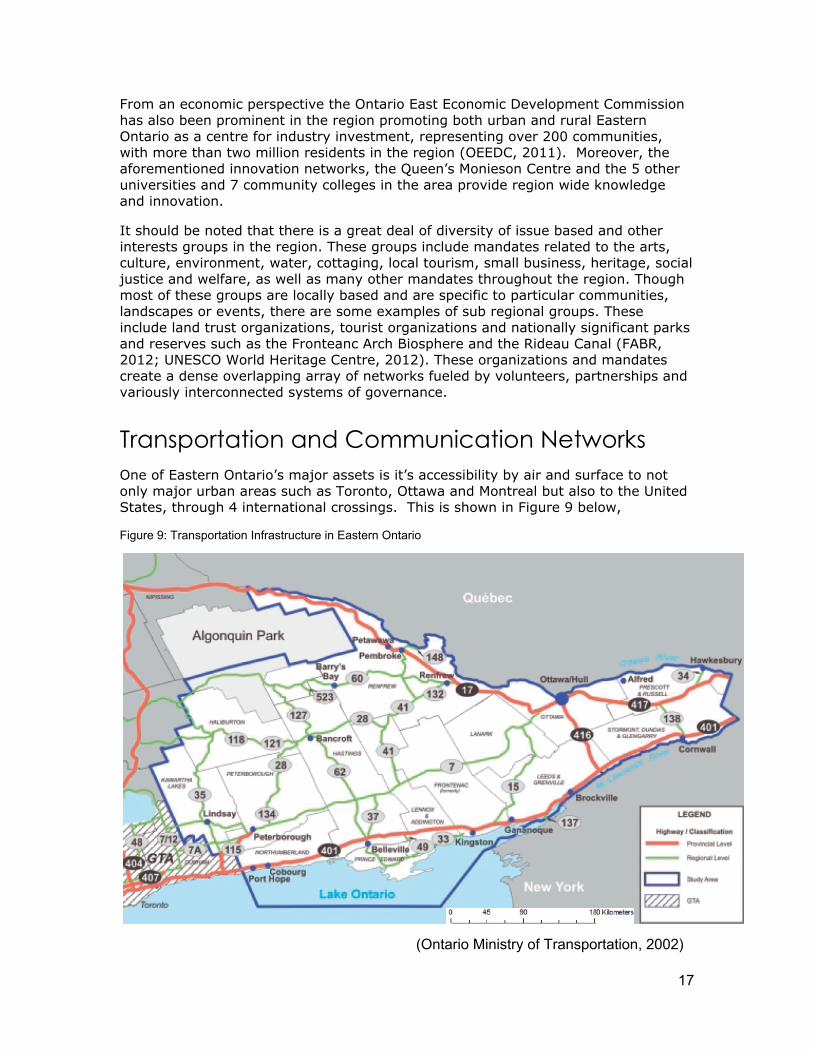
Transportation and Communication Networks One of Eastern Ontario’s major assets is it’s accessibility by air and surface to not only major urban areas such as Toronto, Ottawa and Montreal but also to the United States, through 4 international crossings. This is shown in Figure 9 below,
Figure 9: Transportation Infrastructure in Eastern Ontario
(Ontario Ministry of Transportation, 2002)
18
Eastern Ontario has several 400 series highways, including the east to west corridor of the 401, highway 416 connecting the 401 with Ottawa and the 417 connecting Ottawa with Quebec (EOWC, 2007). Furthermore, Highway 7 (TransCanada Highway) is an important artery through the region. As seen in Figure 9 above, there are also many more vital highways that create ease of access in the region.
In addition to the road transportation, Eastern Ontario has two major rail lines, transporting both cargo and passengers. Connecting the region with the rest of Ontario, Canada and North America are the Canadian National Railway, Canadian Pacific Railway, Ottawa Valley Railway and many short-line railroads (OEEDC, 2011). To complement these train lines and the above mentioned major highways, there are also 5 deep water ports, including the Great Lakes St. Lawrence Seaway System (EOWC, 2007).
VIA rail passenger trains provide service running from east to west in the south corridor and to Ottawa (EOWC, 2007). Furthermore, the region houses 4 airports, including one international airport in Ottawa. Between the additional airports in Syracuse, New York, Toronto and Montreal, most Eastern Ontario communities are within 2 hours of an international airport (OEEDC, 2011).
As mentioned previously it was a priority of the Eastern Ontario Warden’s Caucus to provide high speed internet access throughout the region. The EOWC created the “Eastern Ontario Regional Network” to provide higher speeds and bandwidth to at least 95 per cent of homes and businesses in Eastern Ontario (EORN, 2011). This project is currently underway, with an estimated completion date of 2014 (EORN, 2011). Cell phone reception varies throughout the region. However, it remains very reliable in communities along the major highways and close to regional urban centres such as Ottawa, Kingston, Brockville and Cornwall.
Summary Eastern Ontario is a very large complex and diverse region, with both a regional society with dominantly rural traditions and contexts and one with dominantly urban traditions and contexts. Today one can see these rural and urban traditional binaries changing as the region moves into new and challenging contexts of the global economy, rapidly changing telecommunications and other technologies, climate change and expanding demands upon a long established local government system. In contrast to central and northern Ontario, Eastern Ontario does not have any official regional development policy document, either from the Province of Ontario or from the Federal government relating to longer term region-wide strategic development. The EOWC is currently looking into creating a regional document which may provide a more cohesive regional plan for Eastern Ontario.
19
References
Canada History. (2012). Samuel De Champlain. Retrieved August 1, 2012, from http://www.canadahistory.com/sections/eras/2worldsmeet/champlain/champlain.htm
Conservation Ontario (2012). Conservation Authorities of Ontario. Retrieved January
12, 2012, from http://www.conservationontario.ca/find/southeastern.html EORN. (2011). About EORN. Retrieved August 1, 2012, from
http://www.eorn.ca/about-eorn/ EOWC. (2007). A Profile of Eastern Ontario (Regional Data Set). Retrieved February
14, 2012, from http://www.eowc.org/en/futuredirections/resources/Profile_Eastern_Ont-Regional_Data-Mar3107.pdf
FedDev Ontario. (2011). Evaluation of the Eastern Ontario Development Program.
Retrieved February 11, 2012, from http://www.feddevontario.gc.ca/eic/site/723.nsf/eng/00557.html
Frontenac Arch Biosphere Reserve (FABR). (2012). Experience the Frontenac Arch
Biosphere. Retrieved November 15, 2012, from http://www.explorethearch.ca/residents
Greater Peterborough Innovation Cluster (GPIC).(2013). Partners. Retrieved March
25, 2013, from http://www.innovationcluster.ca/about-us/partners/ Industry Canada. (2011). Canadian Industry Statistics. Retrieved March 22, 2013,
from http://www.ic.gc.ca/eic/site/cis-sic.nsf/eng/home Innovation Cluster. (2012). About Us. Retrieved August 24, 2012, from
http://www.innovationcluster.ca/about-us/ Kingston Historical Society. (2003). Chronology of the History of Kingston. Retrieved
August 1, 2012, from, http://kingstonhistoricalsociety.ca/chronology.html KNET. (2012). First Nation Communities in Ontario. Retrieved August 1, 2012, from
www.communities.knet.ca Lanark County. (2012). County History. Retrieved August 1, 2012, from
http://www.lanarkcounty.ca/Page13.aspx Nature Conservancy Canada (NCC). (2012). Frontenac Arch Natural Area. Retrieved
January 18, 2012, from, http://www.natureconservancy.ca/en/where-we-work/ontario/our-work/frontenac_arch_natural_area.html
20
Ontario Association of Community Futures Development Corporations.(2011). Community Futures Development Corporation. Retrieved January 10, 2012, from, http://www.ontcfdc.com/frame1.asp
Ontario Centres of Excellence (OCE). (2012). What we do. Retrieved March 25, 2013,
from http://www.oce-ontario.org/about-oce Ontario East Economic Development Commission (OEEDC). (2011). Advantage
Ontario East. Retrieved January 12, 2012, from http://www.onteast.com/content/advantage-ontario-east
Ontario Government. (2012a). Ontario Government Ministries. Retrieved July 6,
2012, from http://www.ontario.ca/en/your_government/004974.html Ontario Government. (2012b). History of Government- Introduction. Retrieved July
6, 2012, from http://www.ontario.ca/en/your_government/EC001038.html Ontario Government. (2011). History of Ontario- World Wars. Retrieved August 21,
2012, from http://www.ontario.ca/en/about_ontario/004527.html?openNav=history
Ontario Government. (2010). Ontario’s Regional Innovation Networks. Retrieved
August 21, 2012, from http://www.sse.gov.on.ca/medt/investinontario/en/Pages/bcrd_576.aspx?anchor=10#10
Ontario Ministry of Agriculture and Rural Affairs (OMAFRA). (2011). Climate Zones
and Planting Dates for Vegetables in Ontario. Retrieved March 21, 2013, from http://www.omafra.gov.on.ca/english/crops/facts/climzoneveg.htm
Ontario Ministry of Agriculture and Rural Affairs (OMAFRA). (2009). Canadian and
Ontario Invest in Broadband Access for Eastern Ontario. Retrieved August 24, 2012, from http://www.omafra.gov.on.ca/english/infores/releases/2009/073009a.htm
Ontario Ministry of Economic Development and Trade (MEDI). (2011). Eastern
Ontario Development Fund. Retrieved March 22, 2013, from http://www.ontariocanada.com/ontcan/1medt/econdev/en/ed_eodf_main_en.jsp
Ontario Ministry of Economic Development and Trade (MEDI). (2010). Ontario
Network of Excellence. Retrieved August 26, 2012, from http://www.mri.gov.on.ca/english/programs/one/program.asp
Ontario Ministry of Infrastructure (MOI). (2012). Place to Grow. Retrieved August 26,
2012, from https://www.placestogrow.ca/index.php?option=com_content&task=view&id=9&Itemid=14
Ontario Ministry of Municipal Affairs and Housing (MMAH). (2003). Shape the Future:
Eastern Ontario Smart Growth Panel, Discussion Paper. Retrieved January 12,

21
2012 from http://www.ontla.on.ca/library/repository/mon/6000/10312689.pdf
Ontario Ministry of Natural Resources (MNR). (2012). About Ontario’s Forest.
Retrieved January 5, 2012, from http://www.mnr.gov.on.ca/en/Business/Forests/2ColumnSubPage/STEL02_163390.html
Ontario Ministry of Tourism and Culture (MTC). (2012). Tourism Regions. Retrieved
January 18, 2012, from http://www.mtc.gov.on.ca/en/regions/regions.shtml Ontario Ministry of Training, Colleges and Universities (MTCU). (2009). Employment
Ontario Eastern Region 2009 Annual Labour Market Report. Retrieved August 27, 2012, from http://www.tcu.gov.on.ca/eng/labourmarket/currenttrends/docs/regional/2009east.pdf
Ontario Ministry of Transportation. (2002). Strategic Transportation Directions.
Retrieved July 26, 2012, from http://www.ontla.on.ca/library/repository/mon/3000/10301342.pdf
Ontario Parks. (2012). Signature Landscapes. Retrieved February 12, 2012, from
http://ontariooutdoor.com/landscapes.aspx?language=en Ontario Rural Routes. (2011). Historical Profile- The Marmoraton Mining Company.
Retrieved August 22, 2012, from http://www.ruralroutes.com/1299.html Parks Canada. (2012). National Historic Sites of Canada. Retrieved February 12,
2012, from http://www.pc.gc.ca/Home/progs/lhn-nhs/index.aspx Peterborough CFDC. (2013). Eastern Ontario Development Program. Retrieved March
22, 2013, from http://www.cdc.on.ca/eastern-ontario-development-program Peters, B. (2009). Province Invests in Ontario East. Retrieved August 26, 2012, from
http://www.choosecornwall.ca/eng/news/55/165/Province-Invests-in-Ontario-East/
Queen’s University. (2012). The Monieson Centre. Retrieved August 26, 2012, from
http://business.queensu.ca/centres/monieson/index.php Sherwin, D.F. (2003). Geology, Mineral Deposits and History of Mining in the Tay
River Watershed. Retrieved February 12, 2012, from http://www.tayriver.org/documents/geology_report/geology_report.htm#history
Statistics Canada. (2012a). Statistics Canada, censuses of population, 1981 to 2011.
Information given directly from Statistics Canada and other information retrieved July 28, 2012, from http://www.statcan.gc.ca/pub/92-195-x/2011001/geo/ccs-sru/ccs-sru-eng.htm
Statistics Canada. (2012b). Census Profile. 2011 Census. Statistics Canada
Catalogue no. 98-316-XWE. Ottawa. Retrieved May 29, 2012, from

22
http://www12.statcan.gc.ca/census-recensement/2011/dp-pd/prof/index.cfm?Lang=E
Statistics Canada. (2010). Visual census, Population, Ontario.Retrieved February 28,
from, http://www12.statcan.ca/census-recensement/2006/dp-pd/fs-fi/index.cfm?LANG=ENG&VIEW=D&PRCODE=35&TOPIC_ID=3&format=flash
Statistics Canada (2006a). Commuting Flow Census Subdivisions: Sex (3) for the
Employed Labour Force 15 Years and Over Having a Usual Place of Work of Census Subdivisions, Flows Greater than or Equal to 20, 2006 Census - 20% Sample Data. Catalogue Number 97-561-XCB2006011. Retrieved May 4, 2012, from http://www12.statcan.gc.ca/census-recensement/2006/dp-pd/tbt/Rp-eng.cfm?LANG=E&APATH=3&DETAIL=0&DIM=0&FL=A&FREE=0&GC=0&GID=0&GK=0&GRP=1&PID=90656&PRID=0&PTYPE=88971,97154&S=0&SHOWALL=0&SUB=0&Temporal=2006&THEME=76&VID=0&VNAMEE=&VNAMEF=
Statistics Canada. (2006b). Community Information Database. Retrieved February 8,
2012, from http://www.cid-bdc.ca/home The Canadian Encyclopedia. (2012). Economic History. Retrieved August 21, 2012,
from http://www.thecanadianencyclopedia.com/articles/economic-history The first mine in Ontario.(2012). Canada's History, 92(2), 12. Retrieved February 11,
2013 from, http://web.ebscohost.com.subzero.lib.uoguelph.ca/ehost/detail?sid=bef36980-2597-4710-bdad-bedc19da1c78%40sessionmgr113&vid=1&hid=117&bdata=JnNpdGU9ZWhvc3QtbGl2ZSZzY29wZT1zaXRl#db=aph&AN=74267718
Thousand Islands Watershed Land Trust (TIWLT). (n.d.) Frontenac Arch Natural
Area- Eastern Ontario. Retrieved August 22, 2012, from http://www.tiwlt.ca/sheffield%20final%20May%2017.pdf
UNESCO World Heritage Centre. (2012). Rideau Canal. Retrieved January 18, 2012,
from http://whc.unesco.org/en/list/1221/ Virtual North. (2012). Historic Eastern Ontario. Retrieved August 22, 2012, from
http://www.ontariotravelinformation.ca/eastern/ Watson, K. (2011). United Empire Loyalists. Retrieved August 21, 2012, from
http://www.rideau-info.com/canal/history/loyalists.html
The Canadian Regional Development: A Critical Review of Theory, Practice and Potentials project is a multi-year research initiative funded by the Social Sciences and Humanities Research Council of Canada. The project is investigating how Canadian regional development has evolved over the past two decades and the degree to which Canadian regional development systems have incorporated New Regionalism into their policy and practice.
The project is conducting an empirical assessment of Canadian regional development using a multi-level network, mixed methods case study approach in four provinces: British Columbia, Newfoundland and Labrador, Ontario, and Québec. The assessment of regional development across the case studies is based on the five key themes of New Regionalism: i) collaborative, multi-level governance; ii) integrated versus sectoral and single objective approaches; iii) fostering knowledge flow, learning and innovation; iv) place-based development; and v) rural-urban interaction and interdependence.
The project is lead by Kelly Vodden of the Department of Geography at Memorial University. The research team includes David Douglas (School of Environment Design and Rural Development, University of Guelph), Sean Markey (Geography, Simon Fraser University), and Bill Reimer (Sociology and Anthropology, Concordia University). In addition, graduate students at all four universities are engaged on the project.
Further information on the project can be obtained at http://cdnregdev.ruralresilience.ca. The project has been financially supported in part by the Social Sciences and Humanities Research Council of Canada and the Leslie Harris Centre for Regional Policy and Development.