Embed Size (px)
Citation preview
MUNIBE (Antropologia-Arkeologia) nº 60 117-137 SAN SEBASTIÁN 2009 ISSN 1132-2217
Recibido: 2009-10-10Aceptado: 2009-11-25
A preliminary description of Solutrean occupations inEl Mirón cave (Ramales de la Victoria, Cantabria)
Una descripción preliminar de ocupaciones Solutrensesen la cueva del Mirón (Ramales de la Victoria, Cantabria)
ABSTRACT
A 2m2 sondage excavated by us opportunistically from the base of a treasure-hunters’ crater at the rear of the vestibule in El Mirón Cave,has revealed a sequence of Solutrean (as well as Early Upper Paleolithic and late Middle Paleolithic) levels that underlie the long, completesequence of Magdalenian and Azilian layers in this major site, located in the upper Asón valley of the Cantabrian Cordillera. Far poorer in arti-facts and fauna, and lacking obvious features, in stark contrast to the dark brown, culturally and organically rich Initial, Lower and MiddleMagdalenian levels, the eight thin, relatively poor, and lighter-sediment Solutrean-age levels or lenses are suggestive of very different kindsand intensities of human uses of this large, strategic and versatile cave during Last Glacial Maximum times than those of the Late Glacial.Dated by 14C to between 18 and 19 (and by extrapolation downward, possibly, 20) kya, these levels were formed quickly, banked up as theyare against an ancient, steep, erosional, colluvial-alluvial slope. They seem to attest to short, repeated, specialized human visits to the caveat a time of severe environmental conditions–especially in this upland interior setting. These visits may have been made by small, speciali-zed human groups (e.g., hunting parties) exploiting specific resources (e.g., ibex, red deer, salmon and other fish), perhaps seasonally (sum-mer?), from residential base camps along the Cantabrian coast. This is suggested by the fact that the relatively small lithic artifact assem-blages contain disproportionately large numbers of Solutrean points. Almost all of these (and the few antler points) are broken (indicating thatthey had been used violently) and the points as a group include a wide variety of forms and flint types (and colors), suggesting that the peo-ple who were using El Mirón came from and/or traded with a number of different parts of the Vasco-Cantabrian region. Curiously, for a puta-tive hunting/fishing camp, the Solutrean levels also yielded surprisingly large numbers of artificially or naturally perforated shells and boredred deer canines, suggestive of personal ornamentation and possibly caching or even human burial at the site. Larger exposures of theSolutrean occupation surfaces are needed to test these ideas.
RESUMEN
Un sondeo de 2m2 excavado por nosotros aprovechando la base de un pozo hecho hace tiempo por buscadores de tesoros, al fondo delvestíbulo de la Cueva del Mirón, ha revelado una secuencia de niveles solutrenses (y del Paleolítico superior inicial y Musteriense final) queyacen por debajo de una larga y completa secuencia de estratos magdalenienses y azilienses en este yacimiento mayor, ubicado en el vallealto del Asón de la Cordillera Cantábrica. Mucho más pobres en artefactos y fauna y sin estructuras humanas obvias, en marcado contras-te con los niveles de color pardo oscuro y culturalmente y orgánicamente ricos del Magdaleniense Inicial, Inferior y Medio, los ocho niveleso lentejones delgados y relativamente pobres y de colores más claros de la época solutrense sugieren unos tipos e intensidades de empleohumano de esta cueva tan estratégica y versátil muy diferentes durante el Ultimo Máximo Glacial respecto al Tardiglacial. Datados por fechasde 14C entre unos 18 y 19 (o 20) miles de años BP, estos niveles se formaron rápidamente, puesto que están amontonados sobre la rama ero-sionada de un depósito coluvial-aluvial muy antiguo. Parecen atestiguar la existencia de unas visitas humanas especializadas a la cuevadurante un periodo de condiciones ambientales rigorosas–especialmente en esta zona montañosa del interior cantábrico. Estas visitas podrí-an haber sido de pequeños grupos humanos (p.ej., expediciones de caza) que explotaban recursos específicos (p.ej., cabra montés, cier-vo, salmones, otras peces), tal vez de manera estacional (probablemente veraniega), y con sus bases en yacimientos residenciales a lo largode la costa cantábrica. Esta hipótesis está sugerida por el hecho de que los relativamente pequeños conjuntos líticos contienen unas canti-dades desproporcionadamente grandes de puntas solutrenses. Casi todas estas (y las pocas azagayas de asta) están rotas (evidencia deunos empleos violentos) y las puntas en conjunto incluyen una gran variedad de formas y de tipos (y colores) de sílex, lo cual sugiere quelas gentes que emplearon El Mirón venían de o intercambiaban con diversas áreas de la región vasco-cantábrica. Curiosamente para uncampamento de caza y de pesca, los niveles solutrenses también nos entregaron unas cantidades sorprendentemente grandes de conchasperforadas (artificial- o naturalmente) y de caninos de ciervo perforados, lo cual sugiere el adorno personal o incluso el enterramiento huma-no (hipotético) en el yacimiento. Haría falta excavar unas áreas más amplias de las superficies de ocupación humana para poder probarestas ideas.
Lawrence Guy STRAUS(1,2) and Manuel R. GONZALEZ MORALES(2)
KEY WORDS: Solutrean, Last Glacial Maximum, Cantabrian Cordillera, El Mirón Cave. PALABRAS CLAVES: Solutrense, Ultimo Máximo Glacial, Cordillera Cantábrica, Cueva del Mirón.GAKO-HITZAK: Solutrealdia, Azken Izotz Aro Handia, Kantabriar mendikatea, El Mirón kobazuloa
(1) Department of Anthropology, MSC01 1040, University of New Mexico, Albuquerque, NM 87131-0001, USA.(2) Instituto Internacional de Investigaciones Prehistóricas, Universidad de Cantabria, Avda.de los Castros s/n, 39005 Santander, ESPAÑA.
Munibe Antropologia-Arkeologia 60, 2009pp.117-137
S. C. Aranzadi. Z. E. Donostia/San SebastiánISSN 1132-2217
120 LAWRENCE GUY STRAUS and MANUEL R. GONZALEZ MORALES
1.- INTRODUCTION
Studies of the Solutrean of North AtlanticSpain have revealed apparent gaps in the distri-bution of sites pertaining to the human occupationof Vasco-Cantabria during the Last GlacialMaximum (=LGM: 20.5-17 14C kya) (Straus 1975,1983, 2000; Straus et al. 2000; Rasilla & Straus2007). There are “empty”(or “near-empty”) areasalong the East-West-oriented coastal zone,notably between the basins of the Holocene Ríade Gernika and the Bahía de Santander, betweenthe valleys of the Río Nansa and the Río Bedón,and between the valleys of the Río Sella and theRío Nalón. Furthermore, the known Solutrean set-tlement pattern is heavily dominated by sites loca-ted along that narrow coastal strip, with few genui-nely montane sites. Most (70%) sites are at ≤200m above present sea level (≤ ca. 320 m aboveLGM sea level) and 40% are at ≤100 m abovepresent sea level (≤ ca. 220 m above LGM sealevel). Both these lacunae in the Solutrean site dis-tribution could be partially due to biases in arche-ological research, notably the relative distances tothe places of residence of active prehistorians(e.g., major cities or the palace of the Conde de laVega del Sella in Nueva, Asturias) or to stationsalong the old narrow-gauge railroad line that was amajor means of transportation in the high, ruggedrelief of Vasco-Cantabrian Spain until the recentconstruction of divided highways and modernroads. The situation is slowly changing to someextent with the discovery of new Solutrean sites(e.g., Arlanpe in central Vizcaya on the northernedge of the Cordillera [Ríos et al. 2007]). However,other recent discoveries (e.g., Antoliñako, El Ruso,
La Lluera) have tended to reinforce the extant pat-tern, which consists of clear clusters of major sitesand satellite loci usually near the lower courses ofrivers in the coastal zone and often geographicallylinked via those valleys to one or more montanesites. Major examples include the sites of the Ríade Gernika (Santimamiñe, Antoliñako, Atxeta +Bolinkoba, Atxuri), the sites of the Pas/Saja/Bahíade Santander/Miera area (Altamira, Caranceja,Hornos de la Peña, Castillo, Pasiega, Pendo,Ruso, Camargo, Cobalejos, Morín, Fuente delFrances, Garma, Bona, Salitre), the sites of theRíos Bedón and Cares in eastern Asturias (Cuetode la Mina, Riera, Balmori, Coberizas, TresCalabres+Buxu, Guëlga, Canes, Llonín) and thesites of the Río Nalón valley in central Asturias(Candamo, Lluera, Caldas, Viña).
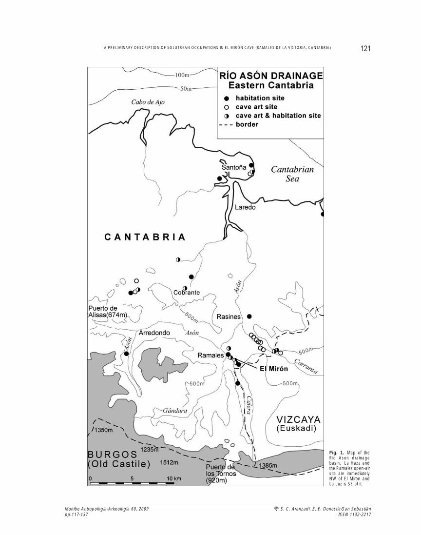
This article is a brief, interim report on theSolutrean levels excavated to date in the montanesite of El Mirón Cave, located in the upper sectorof one of the principal valleys in the heretoforeSolutrean-poor area of eastern Cantabria-westernVizcaya (Encartaciones), namely the Río AsónBasin (Figure 1). El Mirón, scientifically discoveredat the same time as the adjacent cave art sites ofCovalanas and La Haza, in September 1903, byHermilio Alcalde del Río and Lorenzo Sierra, ispart of a greater cluster of unfortunately little-known and/or poorly preserved Upper Paleolithicsites in the area of Ramales de la Victoria. In thecliffs of Monte Pando dominating the confluenceof the Ríos Calera and Gándara with the Asón, arealso located the caves of Cullalvera (UpperMagdalenian), La Luz (Solutrean), El Horno(Upper Magdalenian and Azilian). Only 3-4 km to
LABURPENA
Garai bateko altxor-bilatzaileek El Mirón kobazuloko atariaren barrenean egindako putzu bat baliatuz, 2 metro koadroko zundaketa bat egin dugu.Bertan, solutrialdiko (eta hasierako Goi Paleolitoko eta Musteriar aroaren amaierako) mailen sekuentzia bat aurkitu dugu. Kantabriar mendikatekoAsón ibaiaren goi-haranean dagoen aztarnategi horretan, Madeleinealdiko eta Azilialdiko geruzek osatutako sekuentzia luze eta oso bat ere aurkitudugu Solutrealdiko geruzen gainean. Solutrealdiko geruza horiek ez dira Hasierako Madeleinealdikoak, eta Erdi eta Behe Madeleinealdikoak bezainaberatsak, tresnei eta faunari dagokienez, eta ez dute giza egitura argien aztarnarik eskaintzen. Madeleinealdiko zortzi maila edo lentejoi arre ilunakkulturalki eta organikoki aberatsak dira; aldiz, Solutrealdiko geruza argiagoei erreparatuz gero, esan dezakegu, Azken Izotz Aro Handian eta AroTardiglaziarrean gizakiek ez zutela erabilera anitzeko kobazulo estrategiko hura gauza berak egiteko eta maiztasun berarekin erabili. Karbono-14aren frogak 18 eta 19 (edo 20) mila urte (BP) inguruan datatu ditu geruza horiek. Horrez gain, geruzak oso antzinakoa den biltegi kolubial-alu-bial baten adar higatuaren gainean pilatuta daudela kontuan izanez gero, oso azkar osatu zirela esan dezakegu. Geruza horiek adierazten duteingurumen-baldintzak txarrak zirenean –batez ere kantauriar eskualdearen barnealdean– gizaki-talde batzuk kobazuloan babesten zirela. Taldehoriek talde txikiak izango ziren ziurrenik (esate baterako, ehiza-espedizioak); agian, zenbait urtarotan (ziur asko, udan) baliabide zehatzakustiatzen zituzten (esate baterako, basahuntz piriniarra, oreinak, izokinak eta bestelako arrainak) eta ohiko bizitokiak kantauriar kostaldeanzituzten. Urri samarrak diren talde litikoetan Solutrealdiko punta asko aurkitu dira eta horrek eman digu hipotesi hori egiteko bidea. Puntahorietako gehienak (eta adarrez egindako azagaia urriak) hautsita daude (bortizki erabili izanaren ondorioz), eta itxura, mota (eta kolore) asko-tako silexa erabili zuten horiek egiteko. Hori dela eta, pentsa dezakegu El Mirón kobazuloan bizi izan ziren gizakiak euskal edo kantauriareskualdekoak zirela edo haiekin trukean aritzen zirela. Ehizarako edo arrantzarako erabilitako kanpamentuetan ohikoa izan ez arren,Solutrealdiko geruzetan naturalki edo artifizialki zulatutako oskolak eta oreinen letaginak aurkitu dira; asko, gainera. Horrek apaingarriak era-biltzen zituztela edo aztarnategian gizakiak lurperatzen zituztela pentsatzera garamatza. Hala ere, hipotesi horiek frogatu ahal izateko, giza-kiek bizitoki modura erabili zuten guneko esparru handiagoa induskatu beharko litzateke.
121A PRELIMINARY DESCRIPTION OF SOLUTREAN OCCUPATIONS IN EL MIRÓN CAVE (RAMALES DE LA VICTORIA, CANTABRIA)
Munibe Antropologia-Arkeologia 60, 2009pp.117-137
S. C. Aranzadi. Z. E. Donostia/San SebastiánISSN 1132-2217
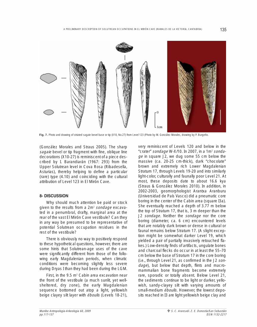
Fig. 1. Map of theRio Ason drainagebasin. La Haza andthe Ramales open-airsite are immediatelyNW of El Miron andLa Luz is SE of it.
the NE along the gorge of the Río Carranza (themain eastern tributary of the Asón) is a string of artand residential sites (Venta de la Perra, Polvorín,Arco A-B-C, Pondra, Sotarriza, Covanegra, Morrodel Oridillo), none of which has (yet) yieldedSolutrean artifactual evidence, although there arered dot outline painting in the Arco caves, Pondraand Morro, which are often attributed to theGravettian or Solutrean periods (González Sainz &San Miguel 2000). Likewise, the many known sitesof the middle and lower Asón (El Valle, El Otero,La Chora, La Fragua, El Perro) all (so far) lackSolutrean materials, although, with a date of18,540 BP, artifact-poor Level 3 of Cobrante mightbe Solutrean (Rasines 2008:61). The early reportson El Mirón (Alcalde del Río 1906:46; Sierra 1908:110; Alcalde del Río et al. 1911:11; Cabré1915:47) mention a variety of Paleolithic periods,although it was never made clear whether the dis-coverers or other early prehistorians (e.g., JuanCabré) had excavated at all in the cave or if thematerials summarily described were scattered onthe surface as the result of previous digging bytreasure-hunters or peasants exploiting organic-rich cave earth for fertilizer and/or to level the ves-tibule rear for livestock stabling. Only Cabré speci-fically mentions the presence of Solutrean artifacts(together with Magdalenian and Azilian ones).Although he turns out to have been correct, we donot know what the source of his information mighthave been. We did find a fragment of a concavebase point (Figures 5.3 and 6.9) in mixed surfacefill at the vestibule rear, so such artifacts do seemto have been brought up by non-archeologicaldiggings in El Mirón in the past, though not fromany crater we have managed to uncover.
Besides El Mirón, the information on theSolutrean occupation of the Upper Asón Valley ishighly sketchy. La Haza yielded a bifacial willowleaf point with an ogival base (Corchón 1971, PlateVI), almost certainly found when the ground surfa-ce of this small art cave was lowered (as in thecase of nearby Covalanas and other caves, suchas those of Monte Castillo) and a gate installed toprepare it for tourist visits (J.González Echegaray,personal communication with LGS in 1973; paceCorchón 1971:157-8). This piece (lost at least as of1973) had been found possibly in 1959, since, in1973, LGS found an empty box labeled “La Haza,1959" in the Provincial Archeological Museum inSantander, although Corchón speaks of “a test pit”
Munibe Antropologia-Arkeologia 60, 2009pp.117-137
S. C. Aranzadi. Z. E. Donostia/San SebastiánISSN 1132-2217
dug in La Haza by the Seminario Sautuola of thatmuseum in 1955 (see Straus 1975, 1983:78;García Diez & Eguizabal 2007:182; Moure et al.1991). (The sedimentary deposits at the mouth ofCovalanas Cave–also apparently not very richarcheologically–were similarly shoveled out byworkmen under the general direction of JesúsCarballo [founding director of the SantanderPrehistory Museum] and supervision of civil engi-neer, Alfredo García Lorenzo, in the period betwe-en 1950-56 [García Diez & Eguizabal 2003:31-32].It was during this time that García Lorenzo directedconstruction of the road up to Covalanas [and theone leading to the Monte Castillo caves, the art intwo of which he discovered and in which he alsodug under Carballo’s general direction] and alsoordered the digging of a trench across the innergallery of El Mirón. None of this “excavating” waspublished.) La Haza is some 400 m. NW and 40 mbelow El Mirón, near the base of El Haza Cliff (thewestern face of Monte Pando).
Below and a few score metres NW of La Hazawere found a few artifacts of Upper Paleolithicaspect during the construction of a group of hou-ses at the upper edge of Ramales in the early1990s (Bohigas et al. n.d.: 27-39, Fig.I). Amongthem are a pair of backed blades, a sidescraperand splintered piece, plus a mesial fragment of aunifacial point with ribbon invasive retouch. Thispiece could either be a pointe à face plane or alarge shouldered point. Whether these objectswere really in situ or had washed down the verysteep slope of the lower cliff (perhaps from one ofthe several other cave mouths therein) is unknown,given that they were surface finds and their contextwas not specified in detail. The present location ofthe point is unknown. Both La Haza and Covalanasmainly contain virtually identical red dot outlinepaintings of red deer hinds, horses, bovines, ibexand signs, generally thought to date between thelate Gravettian and Solutrean (García & Eguizabal2003, 2007; Moure et al. 1991; Apellániz 1982).
La Luz Cave is ca. 200 m SE of and about 60m below El Mirón near the base of La Pared Cliff(the southern face of Monte Pando. It contains afew rupestral engravings (lines and a quadrupedof possibly pre-Magdalenian style)(Montes etal.2003). One shouldered point fragment ofSolutrean aspect was found on the surface andanother in a speleologist-dug pit, along with fau-nal remains, other lithics and some ceramics indi-
122 LAWRENCE GUY STRAUS and MANUEL R. GONZALEZ MORALES
cative of mixing (Gomez et al. 2006). Thus therewere slight (and somewhat uncertain) hints of acluster of minor Solutrean occupations (and pro-bably significant Solutrean cave art) in theRamales area, as well as perhaps at least one sitein the lower Asón valley. The excavation of ElMirón would add significantly to our knowledge ofhuman use of this hinterland area and the Asónvalley in general, a major area between centralCantabria and central Vizcaya that until now hasbeen a large gap in the Solutrean distribution.
2.- EL MIRON CAVE
2.1. The Site
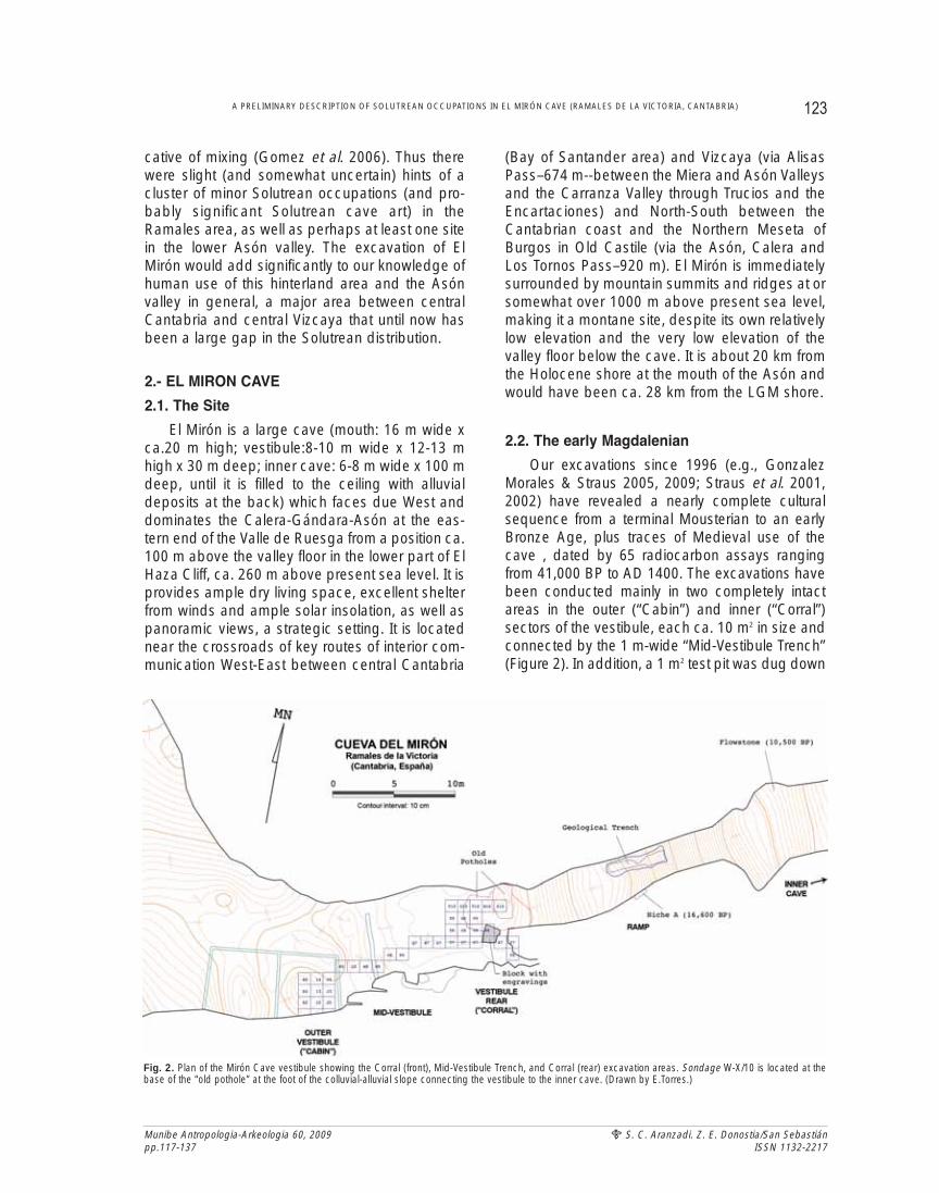
El Mirón is a large cave (mouth: 16 m wide xca.20 m high; vestibule:8-10 m wide x 12-13 mhigh x 30 m deep; inner cave: 6-8 m wide x 100 mdeep, until it is filled to the ceiling with alluvialdeposits at the back) which faces due West anddominates the Calera-Gándara-Asón at the eas-tern end of the Valle de Ruesga from a position ca.100 m above the valley floor in the lower part of ElHaza Cliff, ca. 260 m above present sea level. It isprovides ample dry living space, excellent shelterfrom winds and ample solar insolation, as well aspanoramic views, a strategic setting. It is locatednear the crossroads of key routes of interior com-munication West-East between central Cantabria
(Bay of Santander area) and Vizcaya (via AlisasPass–674 m--between the Miera and Asón Valleysand the Carranza Valley through Trucios and theEncartaciones) and North-South between theCantabrian coast and the Northern Meseta ofBurgos in Old Castile (via the Asón, Calera andLos Tornos Pass–920 m). El Mirón is immediatelysurrounded by mountain summits and ridges at orsomewhat over 1000 m above present sea level,making it a montane site, despite its own relativelylow elevation and the very low elevation of thevalley floor below the cave. It is about 20 km fromthe Holocene shore at the mouth of the Asón andwould have been ca. 28 km from the LGM shore.
2.2. The early Magdalenian
Our excavations since 1996 (e.g., GonzalezMorales & Straus 2005, 2009; Straus et al. 2001,2002) have revealed a nearly complete culturalsequence from a terminal Mousterian to an earlyBronze Age, plus traces of Medieval use of thecave , dated by 65 radiocarbon assays rangingfrom 41,000 BP to AD 1400. The excavations havebeen conducted mainly in two completely intactareas in the outer (“Cabin”) and inner (“Corral”)sectors of the vestibule, each ca. 10 m2 in size andconnected by the 1 m-wide “Mid-Vestibule Trench”(Figure 2). In addition, a 1 m2 test pit was dug down
123A PRELIMINARY DESCRIPTION OF SOLUTREAN OCCUPATIONS IN EL MIRÓN CAVE (RAMALES DE LA VICTORIA, CANTABRIA)
Munibe Antropologia-Arkeologia 60, 2009pp.117-137
S. C. Aranzadi. Z. E. Donostia/San SebastiánISSN 1132-2217
Fig. 2. Plan of the Mirón Cave vestibule showing the Corral (front), Mid-Vestibule Trench, and Corral (rear) excavation areas. Sondage W-X/10 is located at thebase of the “old pothole” at the foot of the colluvial-alluvial slope connecting the vestibule to the inner cave. (Drawn by E.Torres.)
levels with éboulis in immediately adjacent (west-and south-ward) areas of the Corral are blackish,dark grey-brown in color, with patches and lensesof red ochre, fine silts of greenish-greyish color,rich organic content (abundant charcoal, faunalremains, hearths and hearth-sweepings), anddensely packed with lithic and osseous artifactsand manuports (fire-cracked rocks, anvils). Inshort, the contrast between the extraordinarily richearly Magdalenian levels and the underlying Level120 is dramatic. (And the change in color and tex-ture and the appearance of archeological sterilityare what may have caused “treasure-hunters” tostop digging in at least this crater when they rea-ched relatively hard and homogeneous Level 120.)This contrast is mirrored between Levels 313 and314 in the Mid-Vestibule Trench and betweenLevels 17 and 18 in the Corral, although the exacttiming and contemporaneity of this break in the dif-ferent sectors of the Mirón vestibule are not yetproven. The suggestion, however, is that there wasa sharp change in the nature and intensity of thehuman use of the cave between Level 120 timesand Level 119-119.2 times and later.
To determine whether the deposits below thebase of the crater (Level 120) are in fact sterile orarcheologically fertile, we first excavated a 1 m2 pitin square W10 in 1998. This immediately revealedthat the pre-119 levels are indeed fertile, albeitrelatively poor. Excavation was conducted, asusual, by quarter-meter subsquares and by thinspits (ca.3-10 cm), at least in the culturally richupper levels. The spits were thicker (ca.≥10 cm)and excavation was done by small shovel andhand-pick, as well as by the normal trowel, in theculturally very poor basal levels (128-130).Removal of large limestone blocks from the latterlevels was done with the aid of wedges and hand-held hammers, as well as a pneumatic hammer.The sediments were water-screened in the fieldlaboratory, as usual, but because this was a testpit, three-dimensional piece-plotting of finds wasrelatively limited.
At first the deposits immediately underlyingLevel 120 (initially called 400 until its equivalencewith 120 could be physically demonstrated) werecalled Levels 400.1 and 401. Later, in 2000, whenthe crater-base sondage was doubled in size withthe addition of square X10, it was realized that 401could be subdivided into three lenses. By that time,a physical connection had been made between
from the base of the inner cave trench that hadbeen originally excavated by García Lorenzo andsedimentary in-filling of a niche in the cave wallabove the colluvial-alluvial erosional slope thatleads steeply up from the vestibule to the innercave was excavated. Both of these limited testsyielded radiocarbon dates corresponding to theearly Magdalenian and, as of the time of writing(July 2009), the main excavation areas (Cabin andCorral) had also reached early Magdalenianlevels. Specifically, the current base of the Cabinarea (Levels 19-21) dates at most to 16,600 BP(uncal.), the base of the Mid-Vestibule Trench(Level 313) to 17,400 BP, the base of the Corral(Levels 119-119.2) at most to 16,960 BP, Niche Ato 16,600 BP and the inner cave test pit (Level VIII)to 14,620 BP (Straus & González Morales 2003,2007, 2010). All these oldest-to-date strata, exceptthe one in the inner cave test pit, could be labeled“Initial Magdalenian” and one could argue that 1m2 Mid-Vestibule Trench test pit P6 Level 313 couldbe attributed to the Solutrean, based on its strati-graphic position below classic Cantabrian LowerMagdalenian Level 312 and its 14C date. Howeverno Solutrean points have been found (yet), so cau-tion is in order (Straus et al. 2008; Straus &González Morales 2008).
2.3. The W-X/10 sondage at the base of the trea-sure hunters’ crater in the vestibule rear
In addition, a large area of obviously loose, dis-turbed, mixed sediments in the NE corner of thevestibule rear, was identified at the start of our workin the site. This area had been repeatedly dug inrecent times, presumably by looters. This craterwas located at the foot of the steep colluvial-alluvialslope and its deposits were banked up against thesolid, intact boulder, cobble and yellowish-brownsandy silt of that erosional slope. Concurrently withour excavations in intact areas of the vestibule, weemptied the crater, dry-screening some 25 m3 ofsediments that contained a mix of Paleolithic andmodern artifacts. The base of this crater corres-ponds to the top of a stratum (120=ex-400) that isradically different in color, texture and content fromall the Magdalenian levels directly above it. Level120 (on average 12 cm thick) is light yellowish-beige in color and consists of a compact clayeysilt/silty clay with water-worn cobbles and smalléboulis and only a low density of artifacts, charco-al and faunal remains. The overlying, clayey-silt
Munibe Antropologia-Arkeologia 60, 2009pp.117-137
S. C. Aranzadi. Z. E. Donostia/San SebastiánISSN 1132-2217
124 LAWRENCE GUY STRAUS and MANUEL R. GONZALEZ MORALES
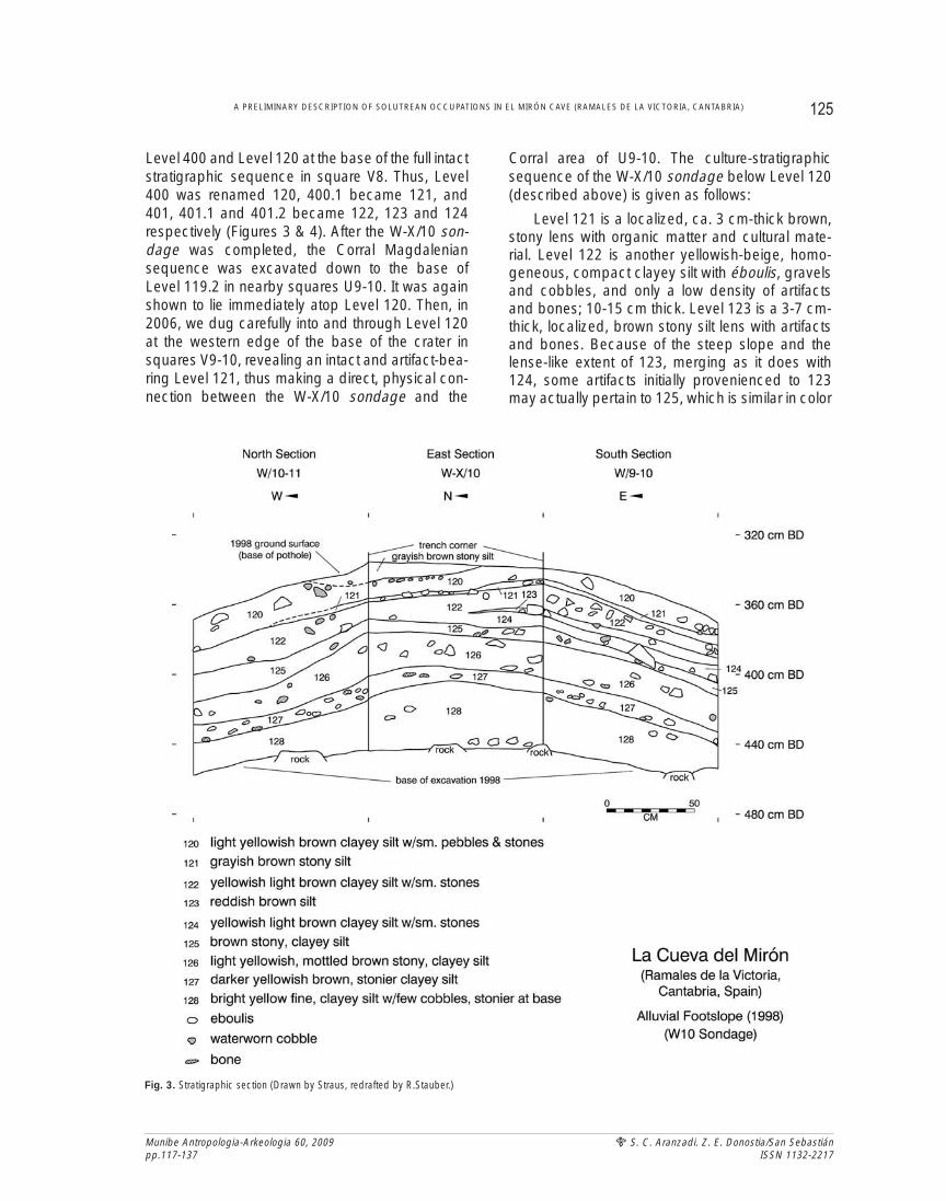
Level 400 and Level 120 at the base of the full intactstratigraphic sequence in square V8. Thus, Level400 was renamed 120, 400.1 became 121, and401, 401.1 and 401.2 became 122, 123 and 124respectively (Figures 3 & 4). After the W-X/10 son-dage was completed, the Corral Magdaleniansequence was excavated down to the base ofLevel 119.2 in nearby squares U9-10. It was againshown to lie immediately atop Level 120. Then, in2006, we dug carefully into and through Level 120at the western edge of the base of the crater insquares V9-10, revealing an intact and artifact-bea-ring Level 121, thus making a direct, physical con-nection between the W-X/10 sondage and the
Corral area of U9-10. The culture-stratigraphicsequence of the W-X/10 sondage below Level 120(described above) is given as follows:
Level 121 is a localized, ca. 3 cm-thick brown,stony lens with organic matter and cultural mate-rial. Level 122 is another yellowish-beige, homo-geneous, compact clayey silt with éboulis, gravelsand cobbles, and only a low density of artifactsand bones; 10-15 cm thick. Level 123 is a 3-7 cm-thick, localized, brown stony silt lens with artifactsand bones. Because of the steep slope and thelense-like extent of 123, merging as it does with124, some artifacts initially provenienced to 123may actually pertain to 125, which is similar in color
125A PRELIMINARY DESCRIPTION OF SOLUTREAN OCCUPATIONS IN EL MIRÓN CAVE (RAMALES DE LA VICTORIA, CANTABRIA)
Munibe Antropologia-Arkeologia 60, 2009pp.117-137
S. C. Aranzadi. Z. E. Donostia/San SebastiánISSN 1132-2217
Fig. 3. Stratigraphic section (Drawn by Straus, redrafted by R.Stauber.)
Munibe Antropologia-Arkeologia 60, 2009pp.117-137
S. C. Aranzadi. Z. E. Donostia/San SebastiánISSN 1132-2217
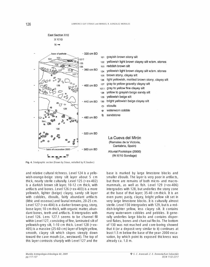
and relative cultural richness. Level 124 is a yello-wish-orange-beige stony silt layer about 5 cmthick, nearly sterile culturally. Level 125 (=ex-402)is a darkish brown silt layer, 10-12 cm thick, withartifacts and bones. Level 126 (=ex-403) is a moreyellowish, lighter (beige) clayey, sandy silt layerwith cobbles, éboulis, fairly abundant artifacts(lithic and osseous) and faunal remains, 20-25 cm.Level 127 (=ex-404) is a darker brown-gray, stony,loose layer, 10 cm-thick, with organic matter, abun-dant bones, teeth and artifacts. It intergrades withLevel 126. Lens 127.1 seems to be channel fillwithin Level 127, consisting of fine, laminated silt ofyellowish-grey silt, 1-10 cm thick. Level 128 (=ex-405) is a massive (25-60 cm) layer of bright yellow,smooth, clayey silt which slopes steeply downtoward the cave mouth (i.e., westward). The top ofthis layer contrasts sharply with Level 127 and the
base is marked by large limestone blocks andsmaller éboulis. The layer is very poor in artifacts,but there are remains of both micro- and macro-mammals, as well as fish. Level 129 (=ex-406)intergrades with 128, but underlies the stony zoneat the base of that layer; 35-40 cm-thick. It is aneven purer, pasty, clayey, bright yellow silt set invery large limestone blocks. It is culturally almoststerile. Level 130 intergrades with 129, but is a red-dish-brighter yellow, less clayey silt. It containsmany water-worn cobbles and pebbles. It gene-rally underlies large blocks and contains disper-sed flakes, bones and charcoal flecks. The bottomof 130 was not reached and core-boring showedthat it (or a deposit very similar to it) continues atleast 1.5 m below the base of the year- 2000 exca-vation, by which point its exposed thickness wasalready ca. 1.0 m.
126 LAWRENCE GUY STRAUS and MANUEL R. GONZALEZ MORALES
Fig. 4. Stratigraphic section (Drawn by Straus, redrafted by R.Stauber.)
The levels of this lower deposit, banked upagainst the “poorly sorted, heterogeneous fluvialdeposits” of the erosional slope, are all sedimento-logically characterized by William Farrand (n.d.;Straus et al. 2001) as variations on the category of“sandy loam”, with differing amounts of cobblesand limestone debris, as well as organic matter,artifacts and faunal remains. It seems apparent thatat least for Levels 120-127, there is an alternationbetween culturally relatively richer and poorerlevels, perhaps reflective of times of human visita-tion to this part of the cave versus episodes of alsorapid, but totally natural deposition (namely viasheet runoff [ruissellement] down the steep erosio-nal slope). The deep, long test trench he and hisstudent William Hubbard dug into the erosionalslope deposits 8-13 m above (East of) the cratertest pit (W-X/10) yielded absolutely no cultural orfaunal remains. These deposits undoubtedly cons-titute the kind of “foundation” material that had beenpartially eroded out of the cave vestibule bystrongly running water (capable of transportingcobbles up to 0.5 m in size) and that clearly preda-ted and underlaid the Upper (and Middle)Paleolithic levels that we have uncovered in thevestibule. In addition, as Farrand (n.d) argues, theerosional slope is a (the) principal source of mine-ral sediments that–together with éboulis (limestoneceiling and wall spall), limited aeolian silt, and oftenabundant anthropogenic and organic mate-rials–formed the late Pleistocene and Holocenedeposits in the vestibule.
The levels (120-130) exposed in the W-X/10sondage generally display a double slope, downtoward both the South and the West, probablyreflecting the geometry of the underlying colluvial-alluvial erosion slope, which may take the form of acone emanating from the mouth of the narrow, fun-nel-like passage leading back and up into the innercave. The slope of all these levels westward downtoward the cave mouth is around 15o. However theslope down toward the South ranges from 5 to 17ºamong the lower levels, while the uppermost levels(120-122) are either flat or slope slightly (ca. 8º)down toward the North. In addition to being far fromflat, this area of the cave vestibule is relatively dark(sunlight reaches it in the late afternoon in summer)and very drafty since it lies in the axis of the passa-ge leading up to the inner cave. Hence we mightdeduce that this was an area that was marginal foractual human occupation, compared with areas ofthe vestibule further toward the West and South.
3- RADIOCARBON CHRONOLOGY OF THE SONDAGE
Level 121 is dated by the conventional method(extended count) on bone collagen from squareV9: 18,390±300 BP (GX-32655). Level 125 isdated by the conventional method on bone colla-gen from square W10 to 18,980±360 BP (GX-24470) and similarly Level 126 is dated to18,950±350 BP (GX-24471). These dates in theCorral area are bracketed by dates of 16,320±160BP for Level 119.2 (in square U9) and 16,960±80BP for overlying Level 119 (in V8) and 27,580±210BP for Level 128 (in square X10). The former twodates correspond to the artifact-rich InitialMagdalenian and the latter to the earlyGravettian/terminal Aurignacian (although withoutdiagnostic artifacts). The dates from levels 125and 126 are statistically identical and suggest veryrapid formation of these levels (and probably 124and 127), which would not be surprising given thesteep underlying slope.
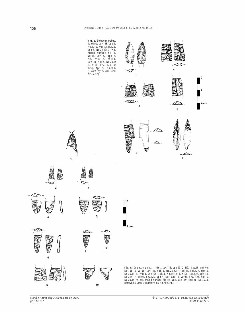
Since Solutrean point fragments have beenfound in levels 120, 123, 124, 125, 126 and 127, itis clear that these deposits were laid down duringthe LGM between ca. 20 kya and ca. 17 kya. Itshould be noted, however, that several small frag-ments of lithic pieces with invasive retouch havebeen found in levels with Magdalenian-periodradiocarbon dates and typically Magdalenianantler and lithic artifacts. These possible or definitepoint fragments include three from Level 116 (onehighly doubtful)(Figure 6.1), two each from Levels119 (Figure 6.10) and 15 (the latter pair being par-ticularly convincing–one bifacial, the other unifa-cial)(Figure 6.2), one (highly problematic) fromLevel 115 and another (probably a unifacialshouldered point base) from Level 17. As notedabove, because of its stratigraphic position andradiocarbon date of 17,400± 270 BP, Level 312 inthe Mid-Vestibule Trench (P6 sondage) might wellpertain to the Solutrean, despite the lack of cha-racteristic points.
4- MICROFAUNAL & OTHER EVIDENCE OFSOLUTREAN ENVIRONMENTS
The rich micromammalian faunas of theSolutrean (and all the other) levels were studied byGloria Cuenca and Juan García Pimienta(Universidad de Zaragoza) (Cuenca et al. 2008,2009). Owls were the principal agents of rodent andinsectivore accumulation. The Solutrean levels are
127A PRELIMINARY DESCRIPTION OF SOLUTREAN OCCUPATIONS IN EL MIRÓN CAVE (RAMALES DE LA VICTORIA, CANTABRIA)
Munibe Antropologia-Arkeologia 60, 2009pp.117-137
S. C. Aranzadi. Z. E. Donostia/San SebastiánISSN 1132-2217
Munibe Antropologia-Arkeologia 60, 2009pp.117-137
S. C. Aranzadi. Z. E. Donostia/San SebastiánISSN 1132-2217
128 LAWRENCE GUY STRAUS and MANUEL R. GONZALEZ MORALES
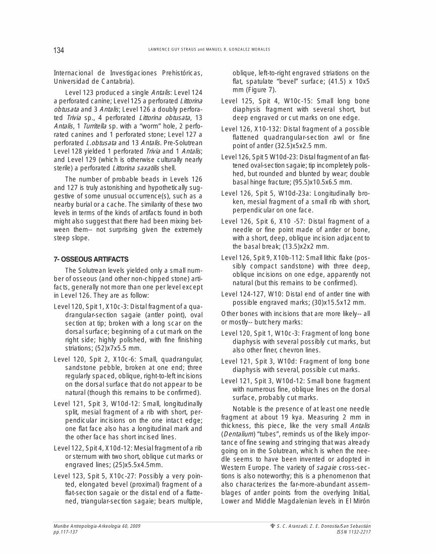
Fig. 6. Solutrean points. 1. U9c, Lev.116, spit 23; 2. H2a, Lev.15, spit 40,No.768; 3. W10d, Lev.126, spit 5, No.23.22; 4. W10c, Lev.127, spit 8,No.35.14; 5. W10b, Lev.125, spit 4, No.14.12; 6. X10c, Lev.127, spit 13,No.219; 7. W10c, Lev.125, spit 4, No.15.18; 8. W10a, Lev. 126, spit 5,No.20.19; 9. W8, mixed surface fill; 10. V8c, Lev.119, spit 28, No.4674.(Drawn by Straus, redrafted by A.Kenward.)
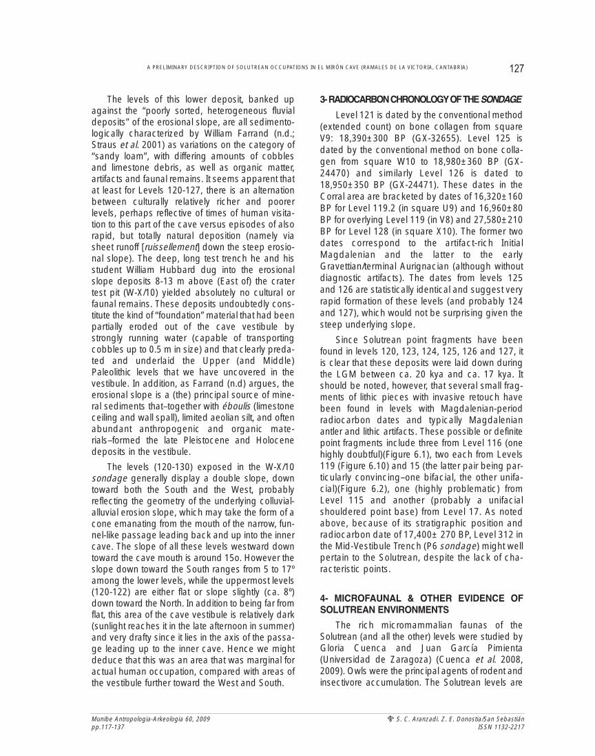
Fig. 5. Solutrean points.1. W10d, Lev.125, spit 4,No.17; 2. W10c, Lev.126,spit 5, No.22.13; 3. W8,mixed surface fill; 4.W10a, Lev.127, spit 7,No. 29.8; 5. W10d,Lev.126, spit 5, No.23.1;6. X10d, Lev. 123 (or125), spit 5, No.28.6(Drawn by S.Ruiz andN.Suarez).
particularly well-endowed with the contents of theirregurgitation pellets. These levels demonstrate thehighest percentages of open grassland speciesand the lowest percentages of woodland ones in thewhole Mirón sequence. Species of barren rocky slo-pes are also very abundant, while water-edge spe-cies are very poorly represented. There is notably amajor spike in the representation of Microtus oeco-nomus, a cold-climate indicator. All of this is indica-tive of the rigorous conditions of the LGM. Theseresults are being corroborated by the palynologicalstudy currently underway by Maria Jose Iriarte(Universidad del País Vasco) (personal communica-tion), which is also showing a scarcity of trees (mainlyscattered pines and some birches) in an otherwiseopen landscape dominated by composites, grassesand heaths during Solutrean times. This picture isconsonant with results from coastal Solutrean sitessuch as La Riera (Straus & Clark 1986).
Although no charcoal from the Solutreanlevels has been identified, several pieces from theunderlying Gravettian/late Aurignacian and lateMousterian levels were determined by LydiaZapata (Universidad del País Vasco) (personalcommunication). These include five fragments ofAlnus (alder) and the knot of an indeterminateAngiosperm from Level 128 and five of indetermi-nate Gymnosperms that could be Pinus (pine)and/or Picea (spruce). These identifications mighthint at somewhat more wooded conditions in thevicinity of the cave in pre-LGM times (ca. 27 kya)than during the Solutrean/LGM.
The Solutrean levels also contain small-moderateamounts of macro-mammalian faunal remains that arenot yet studied, but that, based on field observations,are heavily dominated by ibex and red deer. Thebones are highly fragmented, indicative of intensivebutchering, processing and probably marrow/brainextraction. Fish vertebrae are also very abundant insome of the Solutrean levels. These include both sal-mon and smaller species (S.Consuegra & C.Garcíade Leániz [Centro Ictiológico de Arredondo] personalcommunications).
5- SOLUTREAN ARTIFACT ASSEMBLAGES
Levels 120-128 in squares W-X/10 yielded agrand total of 3701 lithic artifacts, of which 3598are knapping debris (débitage + cores) and 103are retouched tools/weapons, as classifiable bythe standard de Sonneville-Bordes/Perrot typo-
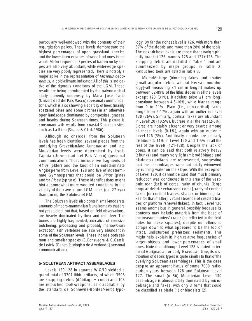
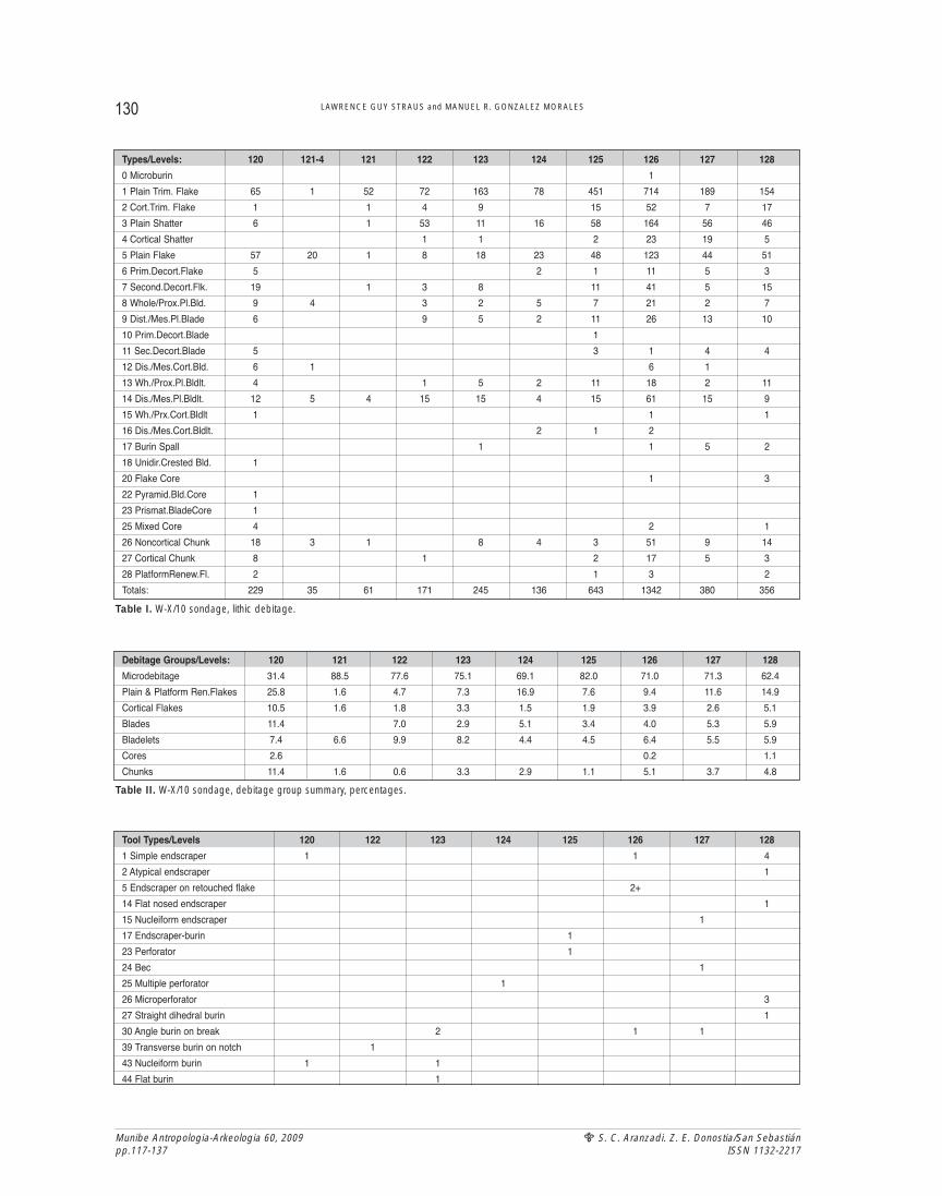
logy. By far the richest level is 126, with more than37% of the debris and more than 28% of the tools.The next-richest levels are those that stratigraphi-cally bracket 126, namely 125 and 127+128. Theknapping debris are detailed in Table 1 and aresummarized by major groups in Table 2.Retouched tools are listed in Table 3.
Microdébitage (trimming flakes and shatter[small angular debris without Herzian morpho-logy]–all measuring ≤1 cm in length) makes upbetween 62-89% of the lithic debris in all the levelsexcept 120 (31%). Bladelets (also ≤1 cm long)constitute between 4.5-10%, while blades rangefrom 0 to 11%. Plain (i.e., non-cortical) flakesrange from 2-17%, again with an outlier in Level120 (26%). Similarly, cortical flakes are abundantin Level120 (10.5%), but rare in all the rest (2-5%).Cores are notably absent or very scarce amongall these levels (0-1%), again with an outlier inLevel 126 (3%). And finally, chunks are similarlydistributed: 11% in Level 120 and 1-5% in all therest of the levels (121-128). Despite the lack ofcores, it can be said that both relatively heavy(chunks) and many very light (microdébitage andbladelets) artifacts are represented, suggestingthat the assemblages were not totally winnowedby running water on the slope. With the exceptionof Level 120, it cannot be said that much primaryreduction was conducted in this area of the vesti-bule rear (lack of cores, rarity of chunks [largeangular debris/ exhausted cores], rarity of corticalflakes [or cortical blades, shatter, or trimming fla-kes for that matter], virtual absence of crested bla-des or platform renewal flakes). In fact, Level 120seems anomalous in general, possibly because itscontents may include materials from the base ofthe treasure hunters’ crater, (as reflected in the fieldnotes for these squares), despite our efforts toscrape down to what appeared to be the top ofintact, undisturbed prehistoric sediments. Thismight help explain its high relative frequencies oflarger objects and lower percentages of smallones. Note that although Level 128 is dated to ter-minal Aurignacian or early Gravettian time, its dis-tribution of debris types is quite similar to that of theoverlying Solutrean assemblages. This is the casedespite an apparent hiatus of some 7000 radio-carbon years between 128 and Solutrean Level127. The small (n=56) Mousterian Level 130assemblage is almost totally dominated by micro-débitage and flakes, with only 3 items that couldbe classified as blade (1) or bladelets (2).
129A PRELIMINARY DESCRIPTION OF SOLUTREAN OCCUPATIONS IN EL MIRÓN CAVE (RAMALES DE LA VICTORIA, CANTABRIA)
Munibe Antropologia-Arkeologia 60, 2009pp.117-137
S. C. Aranzadi. Z. E. Donostia/San SebastiánISSN 1132-2217
Munibe Antropologia-Arkeologia 60, 2009pp.117-137
S. C. Aranzadi. Z. E. Donostia/San SebastiánISSN 1132-2217
130 LAWRENCE GUY STRAUS and MANUEL R. GONZALEZ MORALES
Types/Levels: 120 121-4 121 122 123 124 125 126 127 128
0 Microburin 1
1 Plain Trim. Flake 65 1 52 72 163 78 451 714 189 154
2 Cort.Trim. Flake 1 1 4 9 15 52 7 17
3 Plain Shatter 6 1 53 11 16 58 164 56 46
4 Cortical Shatter 1 1 2 23 19 5
5 Plain Flake 57 20 1 8 18 23 48 123 44 51
6 Prim.Decort.Flake 5 2 1 11 5 3
7 Second.Decort.Flk. 19 1 3 8 11 41 5 15
8 Whole/Prox.Pl.Bld. 9 4 3 2 5 7 21 2 7
9 Dist./Mes.Pl.Blade 6 9 5 2 11 26 13 10
10 Prim.Decort.Blade 1
11 Sec.Decort.Blade 5 3 1 4 4
12 Dis./Mes.Cort.Bld. 6 1 6 1
13 Wh./Prox.Pl.Bldlt. 4 1 5 2 11 18 2 11
14 Dis./Mes.Pl.Bldlt. 12 5 4 15 15 4 15 61 15 9
15 Wh./Prx.Cort.Bldlt 1 1 1
16 Dis./Mes.Cort.Bldlt. 2 1 2
17 Burin Spall 1 1 5 2
18 Unidir.Crested Bld. 1
20 Flake Core 1 3
22 Pyramid.Bld.Core 1
23 Prismat.BladeCore 1
25 Mixed Core 4 2 1
26 Noncortical Chunk 18 3 1 8 4 3 51 9 14
27 Cortical Chunk 8 1 2 17 5 3
28 PlatformRenew.Fl. 2 1 3 2
Totals: 229 35 61 171 245 136 643 1342 380 356
Table I. W-X/10 sondage, lithic debitage.
Debitage Groups/Levels: 120 121 122 123 124 125 126 127 128
Microdebitage 31.4 88.5 77.6 75.1 69.1 82.0 71.0 71.3 62.4
Plain & Platform Ren.Flakes 25.8 1.6 4.7 7.3 16.9 7.6 9.4 11.6 14.9
Cortical Flakes 10.5 1.6 1.8 3.3 1.5 1.9 3.9 2.6 5.1
Blades 11.4 7.0 2.9 5.1 3.4 4.0 5.3 5.9
Bladelets 7.4 6.6 9.9 8.2 4.4 4.5 6.4 5.5 5.9
Cores 2.6 0.2 1.1
Chunks 11.4 1.6 0.6 3.3 2.9 1.1 5.1 3.7 4.8
Table II. W-X/10 sondage, debitage group summary, percentages.
Tool Types/Levels 120 122 123 124 125 126 127 128
1 Simple endscraper 1 1 4
2 Atypical endscraper 1
5 Endscraper on retouched flake 2+
14 Flat nosed endscraper 1
15 Nucleiform endscraper 1
17 Endscraper-burin 1
23 Perforator 1
24 Bec 1
25 Multiple perforator 1
26 Microperforator 3
27 Straight dihedral burin 1
30 Angle burin on break 2 1 1
39 Transverse burin on notch 1
43 Nucleiform burin 1 1
44 Flat burin 1
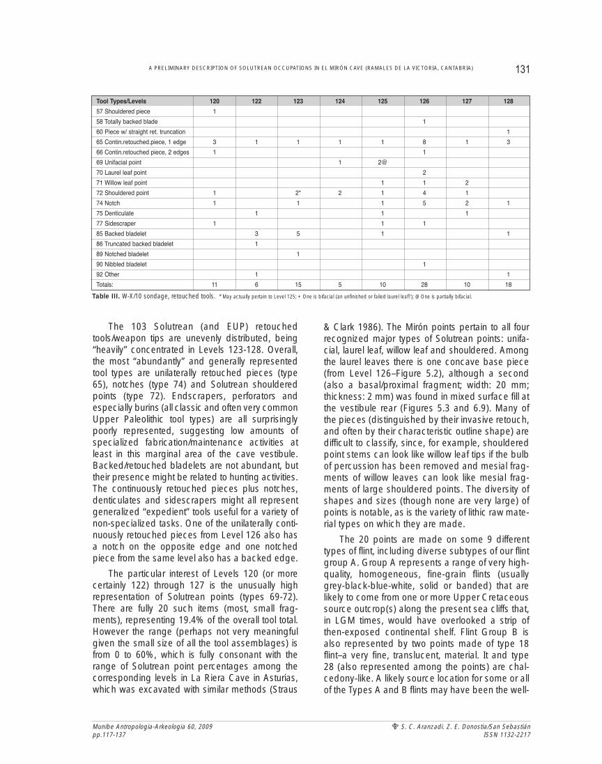
The 103 Solutrean (and EUP) retouchedtools/weapon tips are unevenly distributed, being“heavily” concentrated in Levels 123-128. Overall,the most “abundantly” and generally representedtool types are unilaterally retouched pieces (type65), notches (type 74) and Solutrean shoulderedpoints (type 72). Endscrapers, perforators andespecially burins (all classic and often very commonUpper Paleolithic tool types) are all surprisinglypoorly represented, suggesting low amounts ofspecialized fabrication/maintenance activities atleast in this marginal area of the cave vestibule.Backed/retouched bladelets are not abundant, buttheir presence might be related to hunting activities.The continuously retouched pieces plus notches,denticulates and sidescrapers might all representgeneralized “expedient” tools useful for a variety ofnon-specialized tasks. One of the unilaterally conti-nuously retouched pieces from Level 126 also hasa notch on the opposite edge and one notchedpiece from the same level also has a backed edge.
The particular interest of Levels 120 (or morecertainly 122) through 127 is the unusually highrepresentation of Solutrean points (types 69-72).There are fully 20 such items (most, small frag-ments), representing 19.4% of the overall tool total.However the range (perhaps not very meaningfulgiven the small size of all the tool assemblages) isfrom 0 to 60%, which is fully consonant with therange of Solutrean point percentages among thecorresponding levels in La Riera Cave in Asturias,which was excavated with similar methods (Straus
& Clark 1986). The Mirón points pertain to all fourrecognized major types of Solutrean points: unifa-cial, laurel leaf, willow leaf and shouldered. Amongthe laurel leaves there is one concave base piece(from Level 126–Figure 5.2), although a second(also a basal/proximal fragment; width: 20 mm;thickness: 2 mm) was found in mixed surface fill atthe vestibule rear (Figures 5.3 and 6.9). Many ofthe pieces (distinguished by their invasive retouch,and often by their characteristic outline shape) aredifficult to classify, since, for example, shoulderedpoint stems can look like willow leaf tips if the bulbof percussion has been removed and mesial frag-ments of willow leaves can look like mesial frag-ments of large shouldered points. The diversity ofshapes and sizes (though none are very large) ofpoints is notable, as is the variety of lithic raw mate-rial types on which they are made.
The 20 points are made on some 9 differenttypes of flint, including diverse subtypes of our flintgroup A. Group A represents a range of very high-quality, homogeneous, fine-grain flints (usuallygrey-black-blue-white, solid or banded) that arelikely to come from one or more Upper Cretaceoussource outcrop(s) along the present sea cliffs that,in LGM times, would have overlooked a strip ofthen-exposed continental shelf. Flint Group B isalso represented by two points made of type 18flint–a very fine, translucent, material. It and type28 (also represented among the points) are chal-cedony-like. A likely source location for some or allof the Types A and B flints may have been the well-
131A PRELIMINARY DESCRIPTION OF SOLUTREAN OCCUPATIONS IN EL MIRÓN CAVE (RAMALES DE LA VICTORIA, CANTABRIA)
Munibe Antropologia-Arkeologia 60, 2009pp.117-137
S. C. Aranzadi. Z. E. Donostia/San SebastiánISSN 1132-2217
Tool Types/Levels 120 122 123 124 125 126 127 128
57 Shouldered piece 1
58 Totally backed blade 1
60 Piece w/ straight ret. truncation 1
65 Contin.retouched.piece, 1 edge 3 1 1 1 1 8 1 3
66 Contin.retouched piece, 2 edges 1 1
69 Unifacial point 1 2@
70 Laurel leaf point 2
71 Willow leaf point 1 1 2
72 Shouldered point 1 2* 2 1 4 1
74 Notch 1 1 1 5 2 1
75 Denticulate 1 1 1
77 Sidescraper 1 1 1
85 Backed bladelet 3 5 1 1
86 Truncated backed bladelet 1
89 Notched bladelet 1
90 Nibbled bladelet 1
92 Other 1 1
Totals: 11 6 15 5 10 28 10 18
Table III. W-X/10 sondage, retouched tools. * May actually pertain to Level 125; + One is bifacial (an unfinished or failed laurel leaf?); @ One is partially bifacial.
Munibe Antropologia-Arkeologia 60, 2009pp.117-137
S. C. Aranzadi. Z. E. Donostia/San SebastiánISSN 1132-2217
known outcrops in the cliffs at Barrika, near Bilbaoin central Vizcaya, although there is also a coastalsource of similarly excellent flint at Llaranza, not farfrom Santander in central Cantabria (Rissetto2009). Both these potential sources are about 45-50 km from El Mirón (Barrika via the Carranza Valleyand the Encartaciones area; Llaranza via the AsónValley and the then-broader coastal plain). In addi-tion to the variety of flints among the points found insitu in Levels 120-127, the concave base pointfound in mixed surface fill is made on a fine-graingrey quartzite, much like many of the concavebase points of Asturias (to the West of Cantabria), aregion poor in good-quality, large-nodule flint,where quartzite was the favorite material for makingconcave base points–more so than in flint-richerCantabria. The Mirón Solutrean points are also stri-king for the diversity and sometimes striking natureof their colors, a characteristic of some Solutreansites, as shown long ago by R. and S.de Saint-Périer (1952:16 & frontispiece) in Isturitz (FrenchBasque province of Basse-Navarre) and morerecently in Antoliñako (Vizcaya) by M. Aguirre(1998:127). The diversity of point types and espe-cially of raw material types (all of excellent quality,not available locally) and colors suggest that thepeople who visited El Mirón during Solutrean timeseither came there from various home areas and/ortraded with a number of different regional bandmembers, both to the West and to the East of theAsón Valley.
Among the larger and hence statistically mea-ningful assemblages of lithic artifacts (Levels120,122, 123, 124, 125 and especially 126), theobjects that measure < 1 cm (and thus for whichreliable lithic type attributions can be made) aregenerally overwhelmingly made on group A flints,followed by group B. However, all these assem-blages are marked by the high diversity of lithicraw material types represented: from 15-30, par-tially dependent on assemblage size. Most typesare represented only by trace quantities (i.e., 1-5pieces), but there are a few exceptions, notably 15items of type 82 flint (an unusual, shiny, translucentbright brown flint, with white inclusions) and 12 oftype 31 mudstone in Level 126. In fact, non-flintmaterials (mudstone, quartzite, limestone, quartz,calcite and others) are not generally frequent in theSolutrean levels (unlike in the Initial Magdalenianones right above Level 120), but again there is a bitof an exception again in Level 126–not so much forthe quantity thereof (except the dozen type 31
mudstone items), as for the diversity of non-flints (9types, all believed to be local in origin) that arerepresented. By and large, the Solutrean visitors tothe cave were bringing non-local flints (mainlygroups A and B) with them, probably in the formsof finished tools/weapons, blanks and some cores,the latter of which were further reduced to exhaus-tion (hence the abundance of “chunks”–angulardebris–at the site). Most of these flints almost cer-tainly came from coastal source outcrops, notablyof Upper Cretaceous age. The distribution of lithicraw materials in the Level 128 assemblage is basi-cally similar to that of the larger Solutrean assem-blages (i.e., dominance of group A flints followedby group B, and then trace quantities of manyother types, including a few local mudstones,quartzites, limestone and, exceptionally here, 17pieces of apparently flaked quartz crystal). Thissuggests lithic procurement patterns in the lateAurignacian/early Gravettian visit(s) to the cavethat were very similar to the Solutrean ones. In con-trast, the (admittedly very small) Mousterianassemblage(n=62) from Level 130 has no group Aor B flints (and indeed almost no flints at all!), butrather is composed of a great variety of non-flints(mudstones, limestones, quartzite, sandstoneand especially calcite). This might suggest a radi-cally different kind of site use and territorial mobilityin final Middle Paleolithic times than in the earlyand middle Upper Paleolithic, as well as in all butthe Initial Magdalenian occupations of El Mirón.But these suggestions are made only very cau-tiously, given the small size and marginal locationof the W-X/10 sondage.
The fact that almost all the Solutrean points arefragmentary (one laurel leaf from Level 126 wasactually also classified as a burin on abreak–probably an accident caused by use-impact) suggests that they were broken in hun-ting. The basal fragments may have been broughtback to the cave in their hafts, and the distal (tip)and mesial fragments embedded in meat.
The Solutrean points (Figures 5 & 6) can bedescribed as follows (measurements are length[given in ( ) if fragmentary] x width x thickness.):
Level 120X10-6.17: Shouldered point; Proximal; Unifacial;
Raw material A; (10)x11x3 mm.Level 123X10-28.6: Shouldered point; Whole; Partly bifa-
cial; Raw material 16; 14x12x2 mm.
132 LAWRENCE GUY STRAUS and MANUEL R. GONZALEZ MORALES
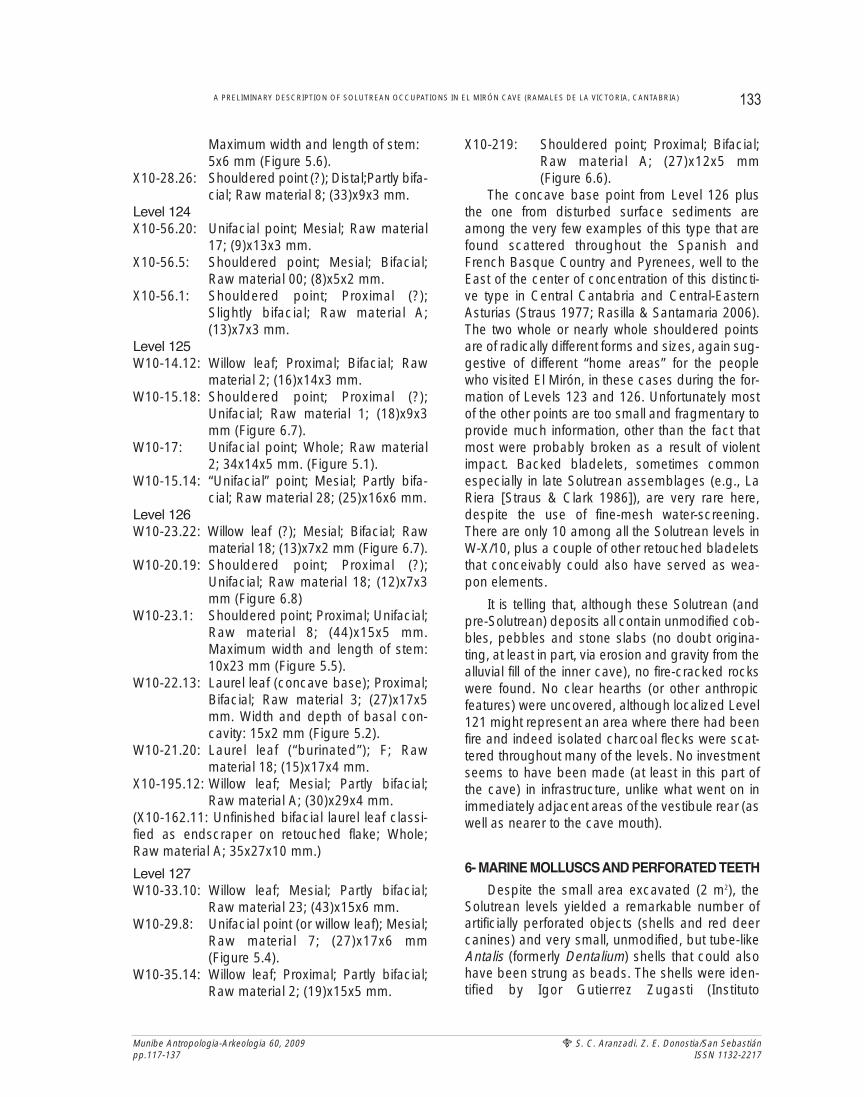
Maximum width and length of stem:5x6 mm (Figure 5.6).
X10-28.26: Shouldered point (?); Distal;Partly bifa-cial; Raw material 8; (33)x9x3 mm.
Level 124X10-56.20: Unifacial point; Mesial; Raw material
17; (9)x13x3 mm.X10-56.5: Shouldered point; Mesial; Bifacial;
Raw material 00; (8)x5x2 mm.X10-56.1: Shouldered point; Proximal (?);
Slightly bifacial; Raw material A;(13)x7x3 mm.
Level 125W10-14.12: Willow leaf; Proximal; Bifacial; Raw
material 2; (16)x14x3 mm.W10-15.18: Shouldered point; Proximal (?);
Unifacial; Raw material 1; (18)x9x3mm (Figure 6.7).
W10-17: Unifacial point; Whole; Raw material2; 34x14x5 mm. (Figure 5.1).
W10-15.14: “Unifacial” point; Mesial; Partly bifa-cial; Raw material 28; (25)x16x6 mm.
Level 126W10-23.22: Willow leaf (?); Mesial; Bifacial; Raw
material 18; (13)x7x2 mm (Figure 6.7).W10-20.19: Shouldered point; Proximal (?);
Unifacial; Raw material 18; (12)x7x3mm (Figure 6.8)
W10-23.1: Shouldered point; Proximal; Unifacial;Raw material 8; (44)x15x5 mm.Maximum width and length of stem:10x23 mm (Figure 5.5).
W10-22.13: Laurel leaf (concave base); Proximal;Bifacial; Raw material 3; (27)x17x5mm. Width and depth of basal con-cavity: 15x2 mm (Figure 5.2).
W10-21.20: Laurel leaf (“burinated”); F; Rawmaterial 18; (15)x17x4 mm.
X10-195.12: Willow leaf; Mesial; Partly bifacial;Raw material A; (30)x29x4 mm.
(X10-162.11: Unfinished bifacial laurel leaf classi-fied as endscraper on retouched flake; Whole;Raw material A; 35x27x10 mm.)
Level 127W10-33.10: Willow leaf; Mesial; Partly bifacial;
Raw material 23; (43)x15x6 mm.W10-29.8: Unifacial point (or willow leaf); Mesial;
Raw material 7; (27)x17x6 mm(Figure 5.4).
W10-35.14: Willow leaf; Proximal; Partly bifacial;Raw material 2; (19)x15x5 mm.
X10-219: Shouldered point; Proximal; Bifacial;Raw material A; (27)x12x5 mm(Figure 6.6).
The concave base point from Level 126 plusthe one from disturbed surface sediments areamong the very few examples of this type that arefound scattered throughout the Spanish andFrench Basque Country and Pyrenees, well to theEast of the center of concentration of this distincti-ve type in Central Cantabria and Central-EasternAsturias (Straus 1977; Rasilla & Santamaria 2006).The two whole or nearly whole shouldered pointsare of radically different forms and sizes, again sug-gestive of different “home areas” for the peoplewho visited El Mirón, in these cases during the for-mation of Levels 123 and 126. Unfortunately mostof the other points are too small and fragmentary toprovide much information, other than the fact thatmost were probably broken as a result of violentimpact. Backed bladelets, sometimes commonespecially in late Solutrean assemblages (e.g., LaRiera [Straus & Clark 1986]), are very rare here,despite the use of fine-mesh water-screening.There are only 10 among all the Solutrean levels inW-X/10, plus a couple of other retouched bladeletsthat conceivably could also have served as wea-pon elements.
It is telling that, although these Solutrean (andpre-Solutrean) deposits all contain unmodified cob-bles, pebbles and stone slabs (no doubt origina-ting, at least in part, via erosion and gravity from thealluvial fill of the inner cave), no fire-cracked rockswere found. No clear hearths (or other anthropicfeatures) were uncovered, although localized Level121 might represent an area where there had beenfire and indeed isolated charcoal flecks were scat-tered throughout many of the levels. No investmentseems to have been made (at least in this part ofthe cave) in infrastructure, unlike what went on inimmediately adjacent areas of the vestibule rear (aswell as nearer to the cave mouth).
6- MARINE MOLLUSCS AND PERFORATED TEETH
Despite the small area excavated (2 m2), theSolutrean levels yielded a remarkable number ofartificially perforated objects (shells and red deercanines) and very small, unmodified, but tube-likeAntalis (formerly Dentalium) shells that could alsohave been strung as beads. The shells were iden-tified by Igor Gutierrez Zugasti (Instituto
133A PRELIMINARY DESCRIPTION OF SOLUTREAN OCCUPATIONS IN EL MIRÓN CAVE (RAMALES DE LA VICTORIA, CANTABRIA)
Munibe Antropologia-Arkeologia 60, 2009pp.117-137
S. C. Aranzadi. Z. E. Donostia/San SebastiánISSN 1132-2217
Munibe Antropologia-Arkeologia 60, 2009pp.117-137
S. C. Aranzadi. Z. E. Donostia/San SebastiánISSN 1132-2217
Internacional de Investigaciones Prehistóricas,Universidad de Cantabria).
Level 123 produced a single Antalis: Level 124a perforated canine; Level 125 a perforated Littorinaobtusata and 3 Antalis; Level 126 a doubly perfora-ted Trivia sp., 4 perforated Littorina obtusata, 13Antalis, 1 Turritella sp. with a “worm” hole, 2 perfo-rated canines and 1 perforated stone; Level 127 aperforated L.obtusata and 13 Antalis. Pre-SolutreanLevel 128 yielded 1 perforated Trivia and 1 Antalis;and Level 129 (which is otherwise culturally nearlysterile) a perforated Littorina saxatilis shell.
The number of probable beads in Levels 126and 127 is truly astonishing and hypothetically sug-gestive of some unusual occurrence(s), such as anearby burial or a cache. The similarity of these twolevels in terms of the kinds of artifacts found in bothmight also suggest that there had been mixing bet-ween them-- not surprising given the extremelysteep slope.
7- OSSEOUS ARTIFACTS
The Solutrean levels yielded only a small num-ber of osseous (and other non-chipped stone) arti-facts, generally not more than one per level exceptin Level 126. They are as follow:
Level 120, Spit 1, X10c-3: Distal fragment of a qua-drangular-section sagaie (antler point), ovalsection at tip; broken with a long scar on thedorsal surface; beginning of a cut mark on theright side; highly polished, with fine finishingstriations; (52)x7x5.5 mm.
Level 120, Spit 2, X10c-6: Small, quadrangular,sandstone pebble, broken at one end; threeregularly spaced, oblique, right-to-left incisionson the dorsal surface that do not appear to benatural (though this remains to be confirmed).
Level 121, Spit 3, W10d-12: Small, longitudinallysplit, mesial fragment of a rib with short, per-pendicular incisions on the one intact edge;one flat face also has a longitudinal mark andthe other face has short incised lines.
Level 122, Spit 4, X10d-12: Mesial fragment of a ribor sternum with two short, oblique cut marks orengraved lines; (25)x5.5x4.5mm.
Level 123, Spit 5, X10c-27: Possibly a very poin-ted, elongated bevel (proximal) fragment of aflat-section sagaie or the distal end of a flatte-ned, triangular-section sagaie; bears multiple,
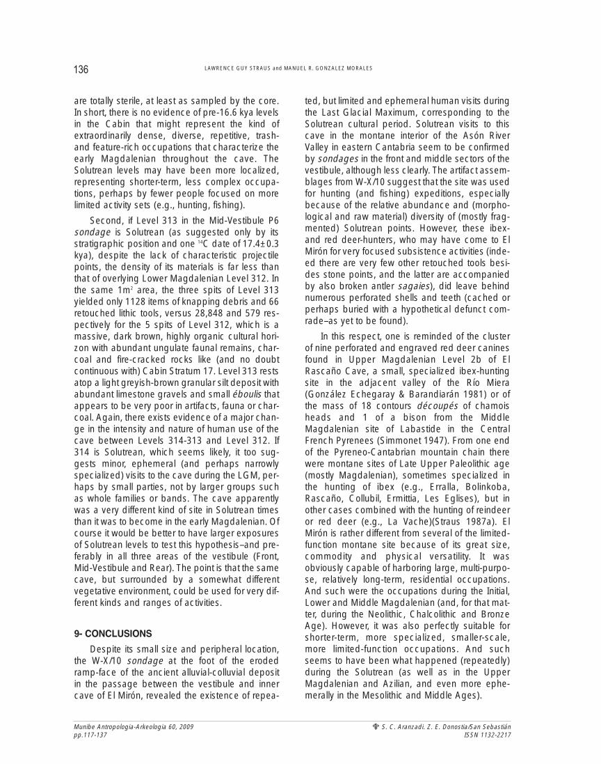
oblique, left-to-right engraved striations on theflat, spatulate “bevel” surface; (41.5) x 10x5mm (Figure 7).
Level 125, Spit 4, W10c-15: Small long bonediaphysis fragment with several short, butdeep engraved or cut marks on one edge.
Level 126, X10-132: Distal fragment of a possibleflattened quadrangular-section awl or finepoint of antler (32.5)x5x2.5 mm.
Level 126, Spit 5 W10d-23: Distal fragment of an flat-tened oval-section sagaie; tip incompletely polis-hed, but rounded and blunted by wear; doublebasal hinge fracture; (95.5)x10.5x6.5 mm.
Level 126, Spit 5, W10d-23a: Longitudinally bro-ken, mesial fragment of a small rib with short,perpendicular on one face.
Level 126, Spit 6, X10 -57: Distal fragment of aneedle or fine point made of antler or bone,with a short, deep, oblique incision adjacent tothe basal break; (13.5)x2x2 mm.
Level 126, Spit 9, X10b-112: Small lithic flake (pos-sibly compact sandstone) with three deep,oblique incisions on one edge, apparently notnatural (but this remains to be confirmed).
Level 124-127, W10: Distal end of antler tine withpossible engraved marks; (30)x15.5x12 mm.
Other bones with incisions that are more likely-- allor mostly-- butchery marks:
Level 120, Spit 1, W10c-3: Fragment of long bonediaphysis with several possibly cut marks, butalso other finer, chevron lines.
Level 121, Spit 3, W10d: Fragment of long bonediaphysis with several, possible cut marks.
Level 121, Spit 3, W10d-12: Small bone fragmentwith numerous fine, oblique lines on the dorsalsurface, probably cut marks.
Notable is the presence of at least one needlefragment at about 19 kya. Measuring 2 mm inthickness, this piece, like the very small Antalis(Dentalium) “tubes”, reminds us of the likely impor-tance of fine sewing and stringing that was alreadygoing on in the Solutrean, which is when the nee-dle seems to have been invented or adopted inWestern Europe. The variety of sagaie cross-sec-tions is also noteworthy; this is a phenomenon thatalso characterizes the far-more-abundant assem-blages of antler points from the overlying Initial,Lower and Middle Magdalenian levels in El Mirón
134 LAWRENCE GUY STRAUS and MANUEL R. GONZALEZ MORALES
(González Morales and Straus 2005). The sharpsagaie bevel or tip fragment with fine, oblique linedecorations (X10-27) is reminiscent of a piece des-cribed by I. Barandiarán (1967: 293) from theUpper Solutrean level in Cova Rosa (Ribadesella,Asturias), thereby helping to define a particular(rare) type (4.10) and coinciding with the culturalattribution of Level 123 in El Mirón Cave.
8- DISCUSSION
Why should much attention be paid or stockgiven to the results from a 2m2 sondage excava-ted in a penumbral, drafty, marginal area at therear of the vast El Mirón Cave vestibule? Can theyin any way be presumed to be representative ofpotential Solutrean occupation residues in therest of the vestibule?
There is obviously no way to positively respondto these hypothetical questions, however, there aresome hints that Solutrean-age uses of the cavewere significantly different from those of the follo-wing early Magdalenian periods, when climaticconditions were becoming slightly less severeduring Dryas I than they had been during the LGM.
First, in the 9.5 m2 Cabin area excavation nearthe front of the vestibule (a much sunlit, yet well-sheltered, dry zone), the early Magdaleniansequence bottomed out atop a light, yellowishbeige clayey silt layer with éboulis (Levels 18-21),
very reminiscent of Levels 120 and below in the“crater” sondage W-X/10. In 2007, in a 1m2 sonda-ge in square J2, we dug some 55 cm below themassive (ca. 20-25 cm-thick), dark “chocolate”brown and extremely rich Lower MagdalenianStratum 17, through Levels 19-20 and into similarlylight-color, culturally and faunally poor Level 21. Atmost, these deposits date to about 16.6 kya(Straus & González Morales 2010). In addition, in2002-2003, geomorphologist Arantxa Aranburu(Universidad de País Vasco) did a pneumatic coreboring in the center of the Cabin area (square I3a).She eventually reached a depth of 3.77 m belowthe top of Stratum 17, that is, 3 m deeper than theJ2 sondage. Neither the sondage nor the coreboring (diameter, ca. 6 cm) encountered levelsthat are notably dark brown or dense in cultural orfaunal remains below Stratum 17. (A slight excep-tion might be somewhat darker Level 19, whichyielded a pair of partially invasively retouched fla-kes.) Low-density finds of artifacts, ungulate bonesand charcoal flecks do occur in at least the 55–70cm below the base of Stratum 17 in the core boring(i.e., through Level 21, as confirmed in the J2 son-dage), but below that depth, flints and macro-mammalian bone fragments become extremelyrare, sporadic or totally absent. Below Level 21,the sediments continue to be light or darker, yello-wish, sandy-clayey silt with varying amounts ofsmall-medium éboulis. However, the lowest depo-sits reached in I3 are light yellowish beige clay and
135A PRELIMINARY DESCRIPTION OF SOLUTREAN OCCUPATIONS IN EL MIRÓN CAVE (RAMALES DE LA VICTORIA, CANTABRIA)
Munibe Antropologia-Arkeologia 60, 2009pp.117-137
S. C. Aranzadi. Z. E. Donostia/San SebastiánISSN 1132-2217
Fig. 7. Photo and drawing of striated sagaie bevel base or tip (X10, No.27) from Level 123 (Photo by M. González Morales, drawing by P. Burgeño.
Munibe Antropologia-Arkeologia 60, 2009pp.117-137
S. C. Aranzadi. Z. E. Donostia/San SebastiánISSN 1132-2217
are totally sterile, at least as sampled by the core.In short, there is no evidence of pre-16.6 kya levelsin the Cabin that might represent the kind ofextraordinarily dense, diverse, repetitive, trash-and feature-rich occupations that characterize theearly Magdalenian throughout the cave. TheSolutrean levels may have been more localized,representing shorter-term, less complex occupa-tions, perhaps by fewer people focused on morelimited activity sets (e.g., hunting, fishing).
Second, if Level 313 in the Mid-Vestibule P6sondage is Solutrean (as suggested only by itsstratigraphic position and one 14C date of 17.4±0.3kya), despite the lack of characteristic projectilepoints, the density of its materials is far less thanthat of overlying Lower Magdalenian Level 312. Inthe same 1m2 area, the three spits of Level 313yielded only 1128 items of knapping debris and 66retouched lithic tools, versus 28,848 and 579 res-pectively for the 5 spits of Level 312, which is amassive, dark brown, highly organic cultural hori-zon with abundant ungulate faunal remains, char-coal and fire-cracked rocks like (and no doubtcontinuous with) Cabin Stratum 17. Level 313 restsatop a light greyish-brown granular silt deposit withabundant limestone gravels and small éboulis thatappears to be very poor in artifacts, fauna or char-coal. Again, there exists evidence of a major chan-ge in the intensity and nature of human use of thecave between Levels 314-313 and Level 312. If314 is Solutrean, which seems likely, it too sug-gests minor, ephemeral (and perhaps narrowlyspecialized) visits to the cave during the LGM, per-haps by small parties, not by larger groups suchas whole families or bands. The cave apparentlywas a very different kind of site in Solutrean timesthan it was to become in the early Magdalenian. Ofcourse it would be better to have larger exposuresof Solutrean levels to test this hypothesis–and pre-ferably in all three areas of the vestibule (Front,Mid-Vestibule and Rear). The point is that the samecave, but surrounded by a somewhat differentvegetative environment, could be used for very dif-ferent kinds and ranges of activities.
9- CONCLUSIONS
Despite its small size and peripheral location,the W-X/10 sondage at the foot of the erodedramp-face of the ancient alluvial-colluvial depositin the passage between the vestibule and innercave of El Mirón, revealed the existence of repea-
ted, but limited and ephemeral human visits duringthe Last Glacial Maximum, corresponding to theSolutrean cultural period. Solutrean visits to thiscave in the montane interior of the Asón RiverValley in eastern Cantabria seem to be confirmedby sondages in the front and middle sectors of thevestibule, although less clearly. The artifact assem-blages from W-X/10 suggest that the site was usedfor hunting (and fishing) expeditions, especiallybecause of the relative abundance and (morpho-logical and raw material) diversity of (mostly frag-mented) Solutrean points. However, these ibex-and red deer-hunters, who may have come to ElMirón for very focused subsistence activities (inde-ed there are very few other retouched tools besi-des stone points, and the latter are accompaniedby also broken antler sagaies), did leave behindnumerous perforated shells and teeth (cached orperhaps buried with a hypothetical defunct com-rade–as yet to be found).
In this respect, one is reminded of the clusterof nine perforated and engraved red deer caninesfound in Upper Magdalenian Level 2b of ElRascaño Cave, a small, specialized ibex-huntingsite in the adjacent valley of the Río Miera(González Echegaray & Barandiarán 1981) or ofthe mass of 18 contours découpés of chamoisheads and 1 of a bison from the MiddleMagdalenian site of Labastide in the CentralFrench Pyrenees (Simmonet 1947). From one endof the Pyreneo-Cantabrian mountain chain therewere montane sites of Late Upper Paleolithic age(mostly Magdalenian), sometimes specialized inthe hunting of ibex (e.g., Erralla, Bolinkoba,Rascaño, Collubil, Ermittia, Les Eglises), but inother cases combined with the hunting of reindeeror red deer (e.g., La Vache)(Straus 1987a). ElMirón is rather different from several of the limited-function montane site because of its great size,commodity and physical versatility. It wasobviously capable of harboring large, multi-purpo-se, relatively long-term, residential occupations.And such were the occupations during the Initial,Lower and Middle Magdalenian (and, for that mat-ter, during the Neolithic, Chalcolithic and BronzeAge). However, it was also perfectly suitable forshorter-term, more specialized, smaller-scale,more limited-function occupations. And suchseems to have been what happened (repeatedly)during the Solutrean (as well as in the UpperMagdalenian and Azilian, and even more ephe-merally in the Mesolithic and Middle Ages).
136 LAWRENCE GUY STRAUS and MANUEL R. GONZALEZ MORALES
While El Mirón, despite its montane location,was clearly a “hub” residential site during the earlyMagdalenian, like the great contemporaneoussites of Altamira and El Juyo in the lowland coastalzone, it was probably more appropriate only forSolutrean logistical use under the more severe cli-matic conditions of the LGM. One should not for-get that, although the maximum extent of glacia-tion had occurred somewhat earlier, theCordilleran summits and high valleys (e.g., CastroValnera) continued to be significantly glaciatedduring Solutrean times, and the deglaciation occu-rred in sawtooth fashion during the Tardiglacial(i.e., Magdalenian)(see González Trueba &Serrano 2008, with references). El Mirón, despitethe relatively limited nature of its Solutrean occu-pations , seems to have been the most importantlocus in a small cluster of Solutrean sites above theconfluence of the Ríos Calera and Gándara withthe Asón at Ramales. This cluster would have hadeven greater significance if indeed the nearby reddot outline cave art sites of Covalanas, La Haza,Pondra and Arco were to be definitely shown to beof Solutrean age, as has been argued many timesin the past (including arguments based on the--sometimes unique or at least prominent--presenceof Solutrean artifacts in several of the red dot outli-ne sites, such as La Haza, La Pasiega, Salitre,and, recently, El Pendo (Straus 1987b; but seeGonzález Sainz & San Miguel 2001). Obviously,however, what is lacking are the base camps in thecoastal lowlands around the mouth of the Asónfrom which (hypothetically) the Solutrean huntingparties went up to El Mirón– possibly in summer.Could they be under water along the now-floodedcontinental shelf, or did the Solutrean hunters whoused the Ramales area come there from coastalbases further afield as the Upper Cretaceous flintsmight suggest, despite the lack of knownSolutrean residential sites near either Barrika orLlaranza? Only future investigations and discove-ries may one day tell...
10- ACKNOWLEDGMENTS
Excavations in El Mirón Cave have beenauthorized since 1996 and partially funded inrecent years by the Consejería de Cultura,Gobierno de Cantabria. Other major sources offunding have been the Fundación M. Botín, theU.S. National Science Foundation, the SpanishMinisterio de Educacion y Ciencia (HUM2006-
13729), the National Geographic Society, theL.S.B.Leakey Foundation and the University ofNew Mexico. The Town of Ramales de la Victoriaand the Universidad de Cantabria have also con-tributed materially to the project. We thank the sco-res of Spanish, New Mexican and other studentsfrom throughout the Americas and Europe whohave participated so constructively in so manyways in the excavations, lab work and analysesover the years. We owe a great debt of gratitude toall the collaborating specialists. We also thankJoaquín (“Pencho”) Eguizabal, Covalanas Caveguide, for his cheerful assistance and friendshipsince the very start.
11. BIBLIOGRAPHY
AGUIRRE, M.
1998 Antoliñako Koba (Gautegiz Arteaga). Arkeoikuska 97,124-129.
ALCALDE DEL RIO, H.
1906 Las Pinturas y Grabados de las Cavernas de la Provinciade Santander. Blanchard y Arce, Santander.
ALCALDE DEL RIO, H.; BREUIL, H. & SIERRA, L.
1911 Les Cavernes de la Région Cantabrique. A.Chêne, Monaco.
APELLANIZ, J.M.
1982 El Arte Prehistórico del País Vasco y sus Vecinos.Desclée de Brouwer, Bilbao.
BARANDIARAN, I.
1967 El Paleomesolítico del Pirineo Occidental. MonografíasArqueológicas III, Zaragoza.
BOHIGAS, R.; LOPEZ, F.; MARTINEZ, R.; MOURE, J.A.; MUÑOZ,E. & PRADO, R.
n.d. Informe espeleológico y arqueológico sobre el proyectode trazado de la “variante de Ramales de la Victoria”.Unpublished report to the Gobierno de Cantabria,Santander.
CABRE, J.
1915 El Arte Rupestre en España. Comisión de InvestigacionesPaleontológicas y Prehistóricas, Memoria 1, Madrid.
CORCHON, M.S.
1971 El Solutrense en Santander. Institución Cultural deCantabria, Santander.
CUENCA-BESCOS, G.; STRAUS, L.; GONZALEZ MORALES, M.& GARCIA PIMIENTA, J.
2008 Paleoclima y paisaje del final del Cuaternario enCantabria: los pequeños mamíferos de la Cueva delMirón. Revista Española de Paleontología 23, 91-126.
137A PRELIMINARY DESCRIPTION OF SOLUTREAN OCCUPATIONS IN EL MIRÓN CAVE (RAMALES DE LA VICTORIA, CANTABRIA)
Munibe Antropologia-Arkeologia 60, 2009pp.117-137
S. C. Aranzadi. Z. E. Donostia/San SebastiánISSN 1132-2217
Munibe Antropologia-Arkeologia 60, 2009pp.117-137
S. C. Aranzadi. Z. E. Donostia/San SebastiánISSN 1132-2217
2009 The reconstruction of past environments through smallmammals: from the Mousterian to the Bronze Age in El MirónCave. Journal of Archaeological Science 36, 947-955.
FARRAND, W.R.
n.d. Sedimentology of El Mirón Cave. Unpublished report inpossession of the authors.
GARCIA DIEZ, M. & EGUIZABAL, J.
2003 La Cueva de Covalanas. Gobierno de Cantabria, Santander.
2007 Los dibujos rojos de estilo paleolítico de la Cueva de LaHaza. Munibe 58, 177-222.
GOMEZ, A., CHAUVIN, A., SAVANTI, F., GUTIERREZ, E. & SERNA, M.
2006 El registro arqueológico de la Cueva de la Luz: nuevasaportaciones. Sautuola 12: 75-88.
GONZALEZ ECHEGARAY, J. & BARANDIARAN, I.
1981 El Paleolítico Superior de la Cueva del Rascaño. Centro deInvestigación y Museo de Altamira, Monografias 3, Santander.
GONZALEZ MORALES, M. & STRAUS, L.G.
2005 The Magdalenian sequence of El Mirón Cave (Cantabria,Spain): an approach to the problem of definition of theLower Magdalenian in Cantabrian Spain. In V.DUJARDIN(ed.) Industrie Osseuse et Parures du Solutréen auMagdalénien en Europe. Mémoires de la SociétéPréhistorique Française 39, Paris, 209-219.
2009 Extraordinary Early Magdalenian finds from El MirónCave, Cantabria. Antiquity 83,267-281.
GONZALEZ SAINZ, C. & C. SAN MIGUEL
2001 Las Cuevas del Desfiladero. Gobierno de Cantabria,Santander.
GONZALEZ TRUEBA, J.J. & E. SERRANO
2008 Picos de Europa: El Macizo de Los Urrieles. In P. Ruiz, E.Serrano, M.A.Poblete & J. Ruiz (eds.) De Castilla al Mar:La Naturaleza del Paisaje en la Montaña Cantábrica.Asociación de Geográfos Españoles-Universidades deValladolid y de Oviedo, Oviedo, 69-98.
MONTES, R.; MUÑOZ, E. & MORLOTE, J.M.
2003 Discovery of Palaeolithic rock engravings in Cueva de laLuz. INORA 37, 1-7.
MOURE, J.A.; GONZALEZ SAINZ,C. & GONZALEZ MORALES, M.
1991 Las Cuevas de Ramales de la Victoria. Arte RupestrePaleolítico en las Cuevas de Covalanas y La Haza.Universidad de Cantabria, Santander.
RASILLA, M. DE LA & SANTAMARIA, D.
2006 Tecnicidad y territorio: las puntas de base cóncava delSolutrense cantábrico. Munibe 57 (2): 149-158.
RASILLA, M. DE LA & STRAUS, L.G.
2007 El poblamiento en la región cantábrica en torno al últimomáximo glacial: Gravetiense y Solutrense. In M.A.FANO(ed.): Las Sociedades del Paleolítico en la RegiónCantábrica. Kobie, Anejo 8 (2004), Bilbao, 209-242.
RASINES, P.
2008 Excavaciones arqueológicas en la cueva de Cobrante. InR.ONTAÑON (ed.): Actuaciones Arqueológicas en Cantabria,2000-2003. Gobierno de Cantabria, Santander, 61-65.
RIOS, J.; IRIARTE, E.; GOMEZ, A.; GARATE, D. & REGALADO, E.
2007 Cueva de Arlanpe (Lemoa). Arkeoikuska 2006, 145-148.
RISSETTO, J.
2009 Late Pleistocene Hunter-Gatherer Lithic Exploitation andMobility Patterns in Eastern Cantabria. Ph.D. dissertation,University of New Mexico.
SAINT-PERIER, R. & S.
1952 La Grotte d’Isturitz III: Les Solutréens, les Aurignaciens etles Moustériens. Archives de l’Institut de PaléontologieHumaine, Mémoire 25, Paris.
SIERRA, L.
1908 Notas para el mapa paletnografico de la Provincia deSantander. Actas y Memorias del 1º Congreso deNaturalistas Españoles, Zaragoza, 103-117.
SIMMONET, G.
1947 Une nouvelle plaquette de pierre gravée magdaléniennede la grotte de Labastide. Bulletin de la SociétéPréhistorique Française 44, 55-64.
STRAUS, L.G.
1975 A Study of the Solutrean in Vasco-Cantabrian Spain.Ph.D. dissertation, University of Chicago.
1977 Thoughts on Solutrean concave base point distribution.Lithic Technology 6:32-35.
1983 El Solutrense Cantábrico. Centro de Interpretación yMuseo de Altamira, Mongrafía 10, Madrid.
1987a Upper Paleolithic ibex hunting in SW Europe. Journal ofArchaeological Science 14, 163-178.
1987b The Paleolithic cave art of Vasco-Cantabrian Spain.Oxford Journal of Archaeology 6, 149-163.
2000 A quarter-century of research on the Solutrean of Vasco-Cantabria, Iberia and beyond. Journal of AnthropologicalResearch 56, 39-58.
STRAUS, L.G.; BICHO, N. & WINEGARDNER, A.
2000 Mapping the Upper Paleolithic regions of Iberia. Journalof Iberian Archaeology 2, 7-42.
STRAUS, L.G. & CLARK, G.A.
1986 La Riera Cave. Anthropological Research Papers 36,Tempe, Arizona.
STRAUS, L.G. & GONZALEZ MORALES, M.R.
2003 El Mirón Cave and the 14C chronology of CantabrianSpain. Radiocarbon 45, 41-58.
2007 Further radiocarbon dates for the Upper Paleolithic of ElMirón Cave. Radiocarbon 49, 1205-1214.
2008 Addendum and correction to “Early Magdalenian variabi-lity: new evidence frm El Mirón Cave, Cantabria, Spain.Journal of Field Archaeology 33, 367-369.
2010 The radiocarbon chronology of El Mirón Cave: new datesfor the initial Magdalenian occupations. Radiocarbon 52,
138 LAWRENCE GUY STRAUS and MANUEL R. GONZALEZ MORALES
STRAUS, L.G.; GONZALEZ MORALES, M.R. & STEWART, E.B.
2008 Early Magdalenian variability: new evidence from ElMirón Cave, Cantabria, Spain. Journal of FieldArchaeology 33:197-218.
STRAUS, L.G.; GONZALEZ MORALES, M.R.; FARRAND, W. &HUBBARD, W.
2001 Sedimentological and stratigraphic observations in ElMirón, a late Quaternary cave site in the CantabrianCordillera, northern Spain. Geoarchaeology 16, 603-630.
STRAUS, L.G.; GONZALEZ MORALES, M.R.; FANO, M. & GAR-CIA-GELABERT, M.P.
2002 Last Glacial human settlement in eastern Cantabria.Journal of Archaeological Science 29, 1403-1414.
139A PRELIMINARY DESCRIPTION OF SOLUTREAN OCCUPATIONS IN EL MIRÓN CAVE (RAMALES DE LA VICTORIA, CANTABRIA)
Munibe Antropologia-Arkeologia 60, 2009pp.117-137
S. C. Aranzadi. Z. E. Donostia/San SebastiánISSN 1132-2217