Embed Size (px)
Citation preview
Hydrol. Earth Syst. Sci., 16, 631–640, 2012www.hydrol-earth-syst-sci.net/16/631/2012/doi:10.5194/hess-16-631-2012© Author(s) 2012. CC Attribution 3.0 License.
Hydrology andEarth System
Sciences
A porewater-based stable isotope approach for the investigation ofsubsurface hydrological processes
J. Garvelmann, C. Kulls, and M. Weiler
Institute of Hydrology, Freiburg im Breisgau, Germany
Correspondence to:J. Garvelmann ([email protected])
Received: 30 September 2011 – Published in Hydrol. Earth Syst. Sci. Discuss.: 11 October 2011Revised: 24 January 2012 – Accepted: 10 February 2012 – Published: 28 February 2012
Abstract. Predicting and understanding subsurface flow-paths is still a crucial issue in hydrological research. Wepresent an experimental approach to reveal present and pastsubsurface flowpaths of water in the unsaturated and satu-rated zone. Two hillslopes in a humid mountainous catch-ment have been investigated. The H2O(liquid) – H2O(vapor)equilibration laser spectroscopy method was used to obtainhigh resolutionδ2H vertical depth profiles of pore water atvarious points along two fall lines of a pasture hillslope inthe southern Black Forest, Germany. The Porewater-basedStable Isotope Profile (PSIP) approach was developed to usethe integrated information of several vertical depth profilesof deuterium along transects at the hillslope.
Different shapes of depth profiles were observed in rela-tion to hillslope position. The statistical variability (inter-quartile range and standard deviation) of each profile wasused to characterize different types of depth profiles. Theprofiles upslope or with a weak affinity for saturation asindicated by a low topographic wetness index preserve theisotopic input signal by precipitation with a distinct sea-sonal variability. These observations indicate mainly verticalmovement of soil water in the upper part of the hillslope be-fore sampling. The profiles downslope or at locations with astrong affinity for saturation do not show a similar seasonalisotopic signal. The input signal is erased in the foothillsand a large proportion of pore water samples are close to theisotopic values ofδ2H in streamwater during base flow con-ditions indicating the importance of the groundwater compo-nent in the catchment. Near the stream indications for effi-cient mixing of water from lateral subsurface flow paths withvertical percolation are found.
1 Introduction
The stable isotope ratios of deuterium (2H) to hydrogen (1H)and of oxygen-18 (18O) to oxygen-16 (16O) of water havebeen used as natural tracers in many studies in order to ex-plore hydrological processes at the hillslope and catchmentscale (e.g. McDonnell, 1990; Kendall and McDonnell, 1998;Uhlenbrook et al., 2002; Vitvar et al., 2005; Tetzlaff etal., 2009). As the stable isotope ratios of precipitation arestrongly correlated with air temperature, a distinct seasonalpattern of rainfall more enriched in heavy isotopes duringsummer and more depleted in winter is found in humid cli-mates (Dansgaard, 1964). In the absence of kinetic fraction-ation this variability determines the atmospheric boundarycondition for hydrological stable isotope studies at the plotscale. The propagation and attenuation of the seasonal iso-tope signal with increasing soil depth allows for an investi-gation of vertical water movement in the unsaturated zone atthe plot scale (Zimmermann et al., 1967; Maloszewski et al.,1983; Stewart and McDonnell, 1991; Gehrels et al., 1998).Vertical stable isotope pore water profiles in the unsaturatedzone have also been used to investigate recharge mechanismsand recharge rates in the vadose zone (e.g. McConville et al.,2001; Saxena, 1984).
The water isotopes in soil water fractionate only slightlyin humid climates. An enrichment of heavy isotopes in thesubsurface may occur in the uppermost part of the soil col-umn due to evaporation. Evaporation from plant intercep-tion or from ponding water in filled surface depressions en-tails kinetic fractionation effects, however transpiration isa non-fractionating process from a hydrological perspective
Published by Copernicus Publications on behalf of the European Geosciences Union.

632 J. Garvelmann et al.: Investigation of subsurface hydrological processes
(Zimmermann et al., 1967; Allison et al., 1984). Mixing, wa-ter uptake by plants and hydrodynamic dispersion alter themeteoric input signal in the unsaturated zone of humid en-vironments (Barnes and Turner, 1998). As a result of theseprocesses an increased attenuation of the isotopic precipita-tion signal with increasing soil depth can be observed reg-ularly. Time series of the stable isotope signature of porewater derived with suction lysimeters at different soil depthsshow this damping behavior (Maloszewski et al., 1983, 2002;Stewart and McDonnell, 1991; DeWalle et al., 1997; Asanoet al., 2002; Wenninger, 2007).
McDonnell et al. (1991) showed that the age of subsurfacewater along a hillslope characterized by an almost imperme-able bedrock base and shallow soil increases considerablyin downslope direction. This lateral aging of soil water iscaused by a constant lateral movement of soil water in thesoil matrix between storms. In a small Japanese catchmentwith weathered bedrock material, Asano et al. (2002) iden-tified only vertical aging of percolating water while no ev-idence of an increase of residence time was found downs-lope. Uchida et al. (2006) integrated these findings and con-cluded that bedrock permeability and soil depth have an ef-fect on the direction of increases of residence time in theunsaturated zone.
Stewart and McDonnell (1991) identified a mean residencetime of more than 100 days for soil water near streams and14 days for soil water upslope. Soil water at shallow depth inunsaturated soil responded to recent rainfall input, whereasdeeper soil water and water near the stream showed muchless variation compared to local precipitation and was con-siderably delayed and attenuated by ongoing mixing and pro-gressive displacement of subsurface water. This behaviorhas also been shown by Horton and Hawkins (1965) andZimmermann et al. (1966) with tritiated (3H) water.
There are numerous techniques for extracting pore waterfrom soil for stable isotope analysis (e.g. suction lysimeter,centrifugation of soil samples, distillation techniques). Thesemethods are technically complex and time-consuming. Com-parisons of pore water extraction techniques reveal large vari-ations in the obtained data and the results appeared not veryaccurate (Ingraham and Shadel, 1992; Walker et al., 1994).Nevertheless these techniques have often been used to extractpore water from soil in certain temporal intervals to gain sub-surface information in hillslope studies. Therefore there isa need for experimental techniques that can be rapidly andefficiently applied at the hillslope scale and that provide use-ful information about subsurface processes and hydrologi-cal hillslope behavior. In this study we further develop theH2O(liquid) – H2O(vapor) equilibration and laser spectroscopymethod presented by Wassennaar et al. (2008) to obtainstable isotope data of pore water of vertical depth profilesalong two transects at a study hillslope. This Porewater-based Stable Isotope Profile (PSIP) approach will be usedto explore the potential of this approach for the investigationof subsurface hydrological processes at the hillslope scale.
We hypothesize that there are locations along the hillslopewhere the isotopic precipitation input signal is preserved inthe unsaturated zone and locations that show an attenua-tion of the meteoric isotope input signal due to mixing andhydrodynamic dispersion.
2 Materials and methods
2.1 Study site
The study area is a 0.9 km2, humid catchment in the south-ern Black Forest, Germany (48◦1′45′′ N, 7◦53′27′′ E). Meanannual precipitation amounts to approximately 1070 mm forthe study area (Trenkle, 1988), the mean annual temperatureis about 9◦C and the mean annual actual evapotranspirationis around 600 mm (WaBoa, 2007). The study was conductedon a north-west facing hillslope covered with pasture and atan elevation of 290 m a.s.l. at the stream and 360 m a.s.l. atthe water divide. There are only a few trees at the water-shed divide and a solitary tree on the hillslope (Fig. 1). Thelength of the hillslope is about 300 m and the mean slopeis 13◦. The soil at the hillslope site is a cambisol with asandy texture. The soil in the riparian zone is an alluvialsoil with a sandy-loamy texture. Typical cambisols in thestudy area have a coarse stone material content from 10 %to 40 %. The transition to the compact bedrock consists of awell-evolved weathering zone. The bedrock is a paragneisswith a fine-grained configuration (Groschopf and Schreiner,1980). The hydrogeology of the bedrock is determined by asystem of connected fissures. The volumetric porosity of thegneiss bedrock is between 0.1 % and 2.1 % and the hydraulicconductivity range from 10−10 m s−1 to 10−5 m s−1 (Sto-ber, 1995). Baseflow components originate from the frac-tured bedrock and the deeper parts of the weathering zone(Uhlenbrook, 1999). There is no evidence for periglacialdrift covers in the study area.
2.2 Fieldwork
The field work was conducted at the end of August 2009.The weather conditions during the field campaign were warmand sunny with daytime temperatures around 25◦C. The to-tal precipitation for August was about 50 mm which is belowthe long-term mean, whereas July was above the long-termmean. Within two field days 15 soil profiles with a depth be-tween 90 cm and 250 cm and a horizontal spacing of approx-imately 40 m were extracted with a gas-powered soil coredrill along two hillslope catenas, labeled as transect T1 andtransect T2 (Fig. 1). Since the hillslope has no clear planartopography, transect T1 was sampled on a convex part of thehillslope and transect T2 in a concave situation. In order toachieve data consistency, the sampling of each transect wasconducted within one day. Since we had no experience re-garding the time it takes to sample one transect, we startedthe first transect (T1) with soil core depths of one meter. We
Hydrol. Earth Syst. Sci., 16, 631–640, 2012 www.hydrol-earth-syst-sci.net/16/631/2012/

J. Garvelmann et al.: Investigation of subsurface hydrological processes 633
Fig. 1. Transect T1 and transect T2 along the study hillslope from above (left) and from below (right).
recognized that sampling of deeper soil profiles is feasiblewithin one day and therefore drilled deeper soil cores at tran-sect T2. The soil cores were divided in the field into sub-samples of 8 cm length, packed into plastic Ziploc bags andstored in a cool box in order to determine the stable isotopiccomposition of the pore water, the gravimetric soil moistureand the soil texture in the lab. Streamwater and groundwa-ter was sampled for stable isotope analysis on the secondfield day (20 August 2009). The streamwater was sampled atthe foot of the study hillslope, whereas the groundwater wassampled in a well about 200 m distance from the hillslope.
2.3 Stable isotope analysis
The stable isotope signature of the pore water was deter-mined by the H2O(liquid) - H2O(vapor) equilibration and laserspectroscopy method. This technique provides the possibil-ity to obtainδ-values of the pore water by measuring the sta-ble isotopic composition of the headspace water vapor in abag with the sampled soil material (Wassennaar et al., 2008).
After breaking the soil samples into smaller aggregatesthe Ziploc backs were filled with completely dehumidifiedair and heat sealed in another plastic back to reduce diffu-sion as much as possible. For calibration two samples withcompletely dried soil material from the experimental hills-lope were moistened with different water isotope standardsof known isotopic composition and treated the same wayas described above. After 15 h in a temperature controlledand air-conditioned room an isotopic equilibrium betweenthe headspace water vapor and the liquid pore water of thesoil material in the plastic bags was assumed. The stable iso-tope analysis of the headspace water vapor of the soil sam-ples and the calibration standards was conducted with aPi-carro Wavelength-Scanned Cavity Ring Down Spectroscopy(WS-CRDS) analyzer. The measurement accuracy for thisanalysis was 0.16 ‰ forδ18O and 0.6 ‰ forδ2H, respec-
tively. Since the WS-CRDS analyzer measuresδ-values rel-ative to an interior standard we used the calibration standardto calculatedδ-values of the headspace water vapor relativeto the Vienna Standard Mean Ocean Water (VSMOW). Un-der the assumption of isotopic equilibrium the phase changein the water liquid – water vapor system can be calculatedwith the fractionation factorα. Sinceα is temperature de-pendent we used the equilibration coefficients according toMajoube (1971) for the measured equilibration temperature(25◦C) of the 15 h equilibration period. Theδ2H valuesof the headspace vapor were subsequently converted via thefractionation factorα into δ2H values of the pore water of thesoil samples. The results are reported inδ notation relative toVSMOW. Because for laser isotope spectrometry the relativemeasurement accuracy is better for deuterium than for18Oand deuterium is less sensitive to kinetic fractionation effects(e.g. evaporation) we used the deuterium values to study thevertical depth profiles of the pore water.
2.4 Additional data analysis
In order to describe the variability of the collected pore waterdeuterium values we show the data per site as boxplots. Theinter quartile range (IQR) of the data describes the variabil-ity between the 25th and the 75th percentiles. The standarddeviations (SD) of the deuterium profile data were calculatedas additional statistical indices describing the variability ofeach vertical depth profile. As a result of dispersion the vari-ability of isotope values along a depth profile is in inverseproportion to the residence time of water.
To describe the topographic location of each profile alongthe transects a LiDAR derived DEM with a resolution of 1 mwas resampled to a spatial resolution of 5 m. The higherresolution appears too susceptible to micro-topographic in-fluences and a slightly lower resolution yields more realis-tic results for hydrological landscape analysis (Jencso et al.,
www.hydrol-earth-syst-sci.net/16/631/2012/ Hydrol. Earth Syst. Sci., 16, 631–640, 2012
634 J. Garvelmann et al.: Investigation of subsurface hydrological processes
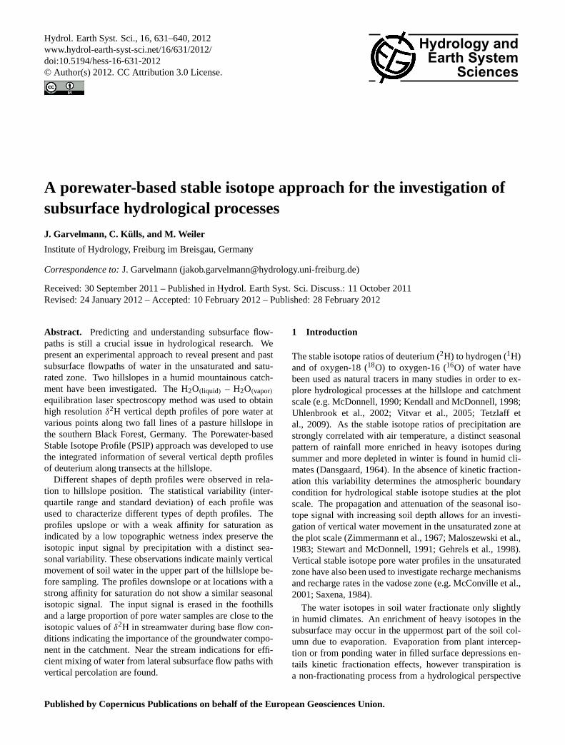
Fig. 2. Gravimetric soil moisture and soil texture with matrix permeability after Scherrer (2006) of soil samples from every vertical depthprofile for both study hillslope transects.
2009). The topographic wetness index (TWI) was calculatedfor every profile position along the study hillslope accordingto the approach described by Beven and Kirkby (1979) withthe multiple triangular flow direction algorithm (Seibert andMcGlynn, 2007).
3 Results
The results of the soil texture analysis and the gravimetricsoil moisture are presented in Fig. 2. The soils at the upperparts of the study hillslope have a high sand content. Thetendency for finer particle sizes is increasing in downslopedirection. The highest soil moisture values were observedat the hillslope foot and also hydromorphic features couldbe found at these near stream profiles. The observed soilmoisture patterns of the upper hillslope soil profiles are verysimilar. The soil properties along the hillslope are very ho-mogenous revealing a high content of sand and therefore agood matrix permeability.
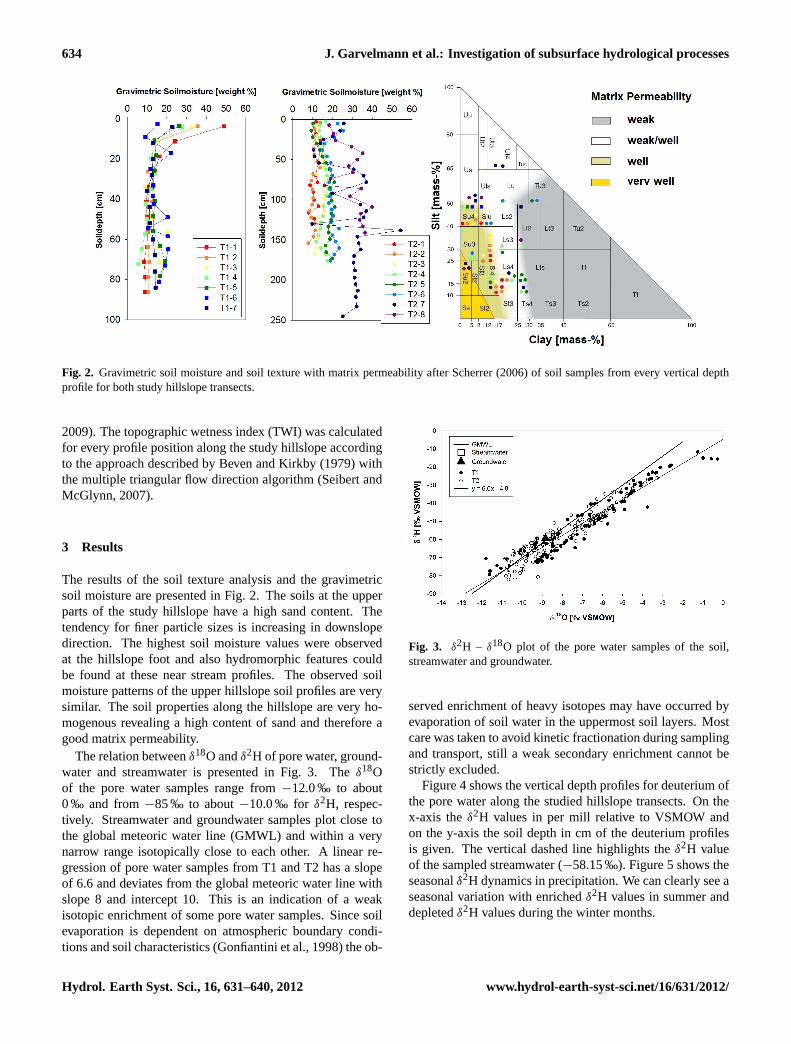
The relation betweenδ18O andδ2H of pore water, ground-water and streamwater is presented in Fig. 3. Theδ18Oof the pore water samples range from−12.0 ‰ to about0 ‰ and from−85 ‰ to about−10.0 ‰ for δ2H, respec-tively. Streamwater and groundwater samples plot close tothe global meteoric water line (GMWL) and within a verynarrow range isotopically close to each other. A linear re-gression of pore water samples from T1 and T2 has a slopeof 6.6 and deviates from the global meteoric water line withslope 8 and intercept 10. This is an indication of a weakisotopic enrichment of some pore water samples. Since soilevaporation is dependent on atmospheric boundary condi-tions and soil characteristics (Gonfiantini et al., 1998) the ob-
Fig. 3. δ2H – δ18O plot of the pore water samples of the soil,streamwater and groundwater.
served enrichment of heavy isotopes may have occurred byevaporation of soil water in the uppermost soil layers. Mostcare was taken to avoid kinetic fractionation during samplingand transport, still a weak secondary enrichment cannot bestrictly excluded.
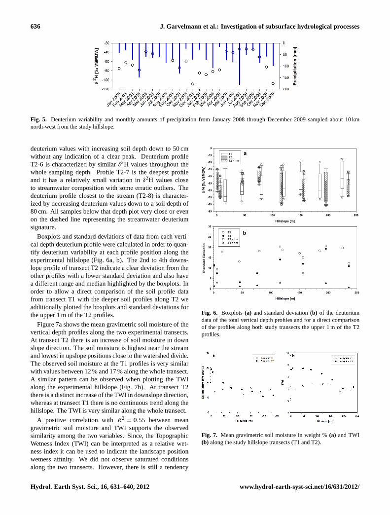
Figure 4 shows the vertical depth profiles for deuterium ofthe pore water along the studied hillslope transects. On thex-axis theδ2H values in per mill relative to VSMOW andon the y-axis the soil depth in cm of the deuterium profilesis given. The vertical dashed line highlights theδ2H valueof the sampled streamwater (−58.15 ‰). Figure 5 shows theseasonalδ2H dynamics in precipitation. We can clearly see aseasonal variation with enrichedδ2H values in summer anddepletedδ2H values during the winter months.
Hydrol. Earth Syst. Sci., 16, 631–640, 2012 www.hydrol-earth-syst-sci.net/16/631/2012/

J. Garvelmann et al.: Investigation of subsurface hydrological processes 635
Fig. 4. Longitudinal profile of transect T1 (top) and transect T2 below with the vertical depth deuterium profiles of pore water. There isa reference plot indicating the soil depth and the deuterium values of the profiles in each study hillslope cross-section. The dashed linerepresents the value of the sampled streamwater.
All vertical depth profiles at transect T1 show a simi-lar characteristic. Theδ2H values are getting continuouslylighter with increasing soil depth. The soil depth with thelightest deuterium value can be interpreted as the precipi-tation falling during the winter with the lightest deuteriumvalues. In most profiles the winter minimum is observed ata depth of 45 to 65 cm. Below this peak there is a trend to-wards heavierδ2H values again. Thus, the vertical depth deu-terium profiles along transect T1 show a typical seasonal pat-tern: soil water stemming from summer rainfall near the sur-
face and an increasing proportion of soil water from winterprecipitation with increasing soil depth.
In contrast to hillslope transect T1, the deuterium profilesat T2 show a partly different behavior. The deuterium pro-files T2-1, T2-2, T2-3 and T2-4 also still exhibit the seasonalvariation described before. The values are getting more de-pleted with depth and the peak of the winter precipitation isfound between 62 cm and 87 cm from the soil surface. Be-low the winter-peak values are getting isotopically enrichedagain. Deuterium profile T2-5 shows a continuous decline of
www.hydrol-earth-syst-sci.net/16/631/2012/ Hydrol. Earth Syst. Sci., 16, 631–640, 2012
636 J. Garvelmann et al.: Investigation of subsurface hydrological processes
Fig. 5. Deuterium variability and monthly amounts of precipitation from January 2008 through December 2009 sampled about 10 kmnorth-west from the study hillslope.
deuterium values with increasing soil depth down to 50 cmwithout any indication of a clear peak. Deuterium profileT2-6 is characterized by similarδ2H values throughout thewhole sampling depth. Profile T2-7 is the deepest profileand it has a relatively small variation inδ2H values closeto streamwater composition with some erratic outliers. Thedeuterium profile closest to the stream (T2-8) is character-ized by decreasing deuterium values down to a soil depth of80 cm. All samples below that depth plot very close or evenon the dashed line representing the streamwater deuteriumsignature.
Boxplots and standard deviations of data from each verti-cal depth deuterium profile were calculated in order to quan-tify deuterium variability at each profile position along theexperimental hillslope (Fig. 6a, b). The 2nd to 4th downs-lope profile of transect T2 indicate a clear deviation from theother profiles with a lower standard deviation and also havea different range and median highlighted by the boxplots. Inorder to allow a direct comparison of the soil profile datafrom transect T1 with the deeper soil profiles along T2 weadditionally plotted the boxplots and standard deviations forthe upper 1 m of the T2 profiles.
Figure 7a shows the mean gravimetric soil moisture of thevertical depth profiles along the two experimental transects.At transect T2 there is an increase of soil moisture in downslope direction. The soil moisture is highest near the streamand lowest in upslope positions close to the watershed divide.The observed soil moisture at the T1 profiles is very similarwith values between 12 % and 17 % along the whole transect.A similar pattern can be observed when plotting the TWIalong the experimental hillslope (Fig. 7b). At transect T2there is a distinct increase of the TWI in downslope direction,whereas at transect T1 there is no continuous trend along thehillslope. The TWI is very similar along the whole transect.
A positive correlation withR2= 0.55 between mean
gravimetric soil moisture and TWI supports the observedsimilarity among the two variables. Since, the TopographicWetness Index (TWI) can be interpreted as a relative wet-ness index it can be used to indicate the landscape positionwetness affinity. We did not observe saturated conditionsalong the two transects. However, there is still a tendency
Fig. 6. Boxplots (a) and standard deviation(b) of the deuteriumdata of the total vertical depth profiles and for a direct comparisonof the profiles along both study transects the upper 1 m of the T2profiles.
Fig. 7. Mean gravimetric soil moisture in weight %(a) and TWI(b) along the study hillslope transects (T1 and T2).
Hydrol. Earth Syst. Sci., 16, 631–640, 2012 www.hydrol-earth-syst-sci.net/16/631/2012/
J. Garvelmann et al.: Investigation of subsurface hydrological processes 637
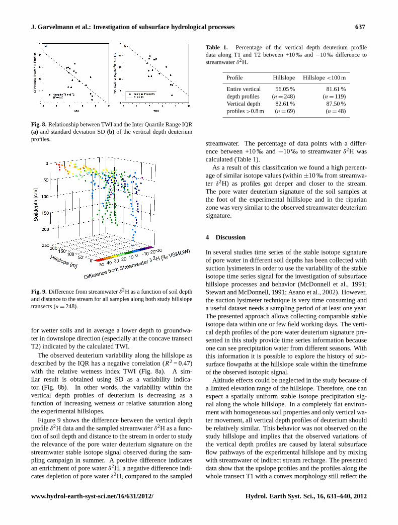
Fig. 8. Relationship between TWI and the Inter Quartile Range IQR(a) and standard deviation SD(b) of the vertical depth deuteriumprofiles.
Fig. 9. Difference from streamwaterδ2H as a function of soil depthand distance to the stream for all samples along both study hillslopetransects (n = 248).
for wetter soils and in average a lower depth to groundwa-ter in downslope direction (especially at the concave transectT2) indicated by the calculated TWI.
The observed deuterium variability along the hillslope asdescribed by the IQR has a negative correlation (R2 = 0.47)with the relative wetness index TWI (Fig. 8a). A sim-ilar result is obtained using SD as a variability indica-tor (Fig. 8b). In other words, the variability within thevertical depth profiles of deuterium is decreasing as afunction of increasing wetness or relative saturation alongthe experimental hillslopes.
Figure 9 shows the difference between the vertical depthprofileδ2H data and the sampled streamwaterδ2H as a func-tion of soil depth and distance to the stream in order to studythe relevance of the pore water deuterium signature on thestreamwater stable isotope signal observed during the sam-pling campaign in summer. A positive difference indicatesan enrichment of pore waterδ2H, a negative difference indi-cates depletion of pore waterδ2H, compared to the sampled
Table 1. Percentage of the vertical depth deuterium profiledata along T1 and T2 between +10 ‰ and−10 ‰ difference tostreamwaterδ2H.
Profile Hillslope Hillslope<100 m
Entire vertical 56.05 % 81.61 %depth profiles (n = 248) (n = 119)Vertical depth 82.61 % 87.50 %profiles>0.8 m (n = 69) (n = 48)
streamwater. The percentage of data points with a differ-ence between +10 ‰ and−10 ‰ to streamwaterδ2H wascalculated (Table 1).
As a result of this classification we found a high percent-age of similar isotope values (within±10 ‰ from streamwa-ter δ2H) as profiles got deeper and closer to the stream.The pore water deuterium signature of the soil samples atthe foot of the experimental hilllslope and in the riparianzone was very similar to the observed streamwater deuteriumsignature.
4 Discussion
In several studies time series of the stable isotope signatureof pore water in different soil depths has been collected withsuction lysimeters in order to use the variability of the stableisotope time series signal for the investigation of subsurfacehillslope processes and behavior (McDonnell et al., 1991;Stewart and McDonnell, 1991; Asano et al., 2002). However,the suction lysimeter technique is very time consuming anda useful dataset needs a sampling period of at least one year.The presented approach allows collecting comparable stableisotope data within one or few field working days. The verti-cal depth profiles of the pore water deuterium signature pre-sented in this study provide time series information becauseone can see precipitation water from different seasons. Withthis information it is possible to explore the history of sub-surface flowpaths at the hillslope scale within the timeframeof the observed isotopic signal.
Altitude effects could be neglected in the study because ofa limited elevation range of the hillslope. Therefore, one canexpect a spatially uniform stable isotope precipitation sig-nal along the whole hillslope. In a completely flat environ-ment with homogeneous soil properties and only vertical wa-ter movement, all vertical depth profiles of deuterium shouldbe relatively similar. This behavior was not observed on thestudy hillslope and implies that the observed variations ofthe vertical depth profiles are caused by lateral subsurfaceflow pathways of the experimental hillslope and by mixingwith streamwater of indirect stream recharge. The presenteddata show that the upslope profiles and the profiles along thewhole transect T1 with a convex morphology still reflect the
www.hydrol-earth-syst-sci.net/16/631/2012/ Hydrol. Earth Syst. Sci., 16, 631–640, 2012
638 J. Garvelmann et al.: Investigation of subsurface hydrological processes
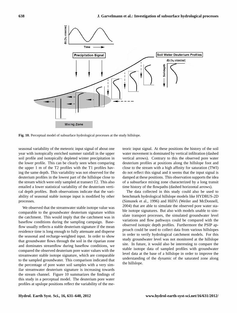
Fig. 10. Perceptual model of subsurface hydrological processes at the study hillslope.
seasonal variability of the meteoric input signal of about oneyear with isotopically enriched summer rainfall in the uppersoil profile and isotopically depleted winter precipitation inthe lower profile. This can be clearly seen when comparingthe upper 1 m of the T2 profiles with the T1 profiles hav-ing the same depth. This variability was not observed for thedeuterium profiles in the lowest part of the hillslope close tothe stream which were only sampled at transect T2. This alsoentailed a lower statistical variability of the deuterium verti-cal depth profiles. Both observations indicate that the vari-ability of seasonal stable isotope input is modified by otherprocesses.
We observed that the streamwater stable isotope value wascomparable to the groundwater deuterium signature withinthe catchment. This would imply that the catchment was inbaseflow conditions during the sampling campaign. Base-flow usually reflects a stable deuterium signature if the meanresidence time is long enough to fully attenuate and dispersethe seasonal and recharge-weighted input. In order to showthat groundwater flows through the soil in the riparian zoneand dominates streamflow during baseflow conditions, wecompared the observed deuterium pore water values with thestreamwater stable isotope signature, which are comparableto the sampled groundwater. This comparison indicated thatthe percentage of pore water soil samples with a very sim-ilar streamwater deuterium signature is increasing towardsthe stream channel. Figure 10 summarizes the findings ofthis study in a perceptual model. The deuterium pore waterprofiles at upslope positions reflect the variability of the me-
teoric input signal. At these positions the history of the soilwater movement is dominated by vertical infiltration (dashedvertical arrows). Contrary to this the observed pore waterdeuterium profiles at positions along the hillslope foot andclose to the stream with a high affinity for saturation (TWI)do not reflect this signal and it seems that the input signal isdamped at these positions. This observation supports the ideaof a subsurface mixing zone characterized by a long transittime history of the flowpaths (dashed horizontal arrows).
The data collected in this study could also be used tobenchmark hydrological hillslope models like HYDRUS-2D(Simunek et al., 1996) and HillVi (Weiler and McDonnell,2004) that are able to simulate the observed pore water sta-ble isotope signatures. But also with models unable to sim-ulate transport processes, the simulated groundwater levelvariations and flow pathways could be compared with theobserved isotopic depth profiles. Furthermore the PSIP ap-proach could be used to collect data from various hillslopesin order to verify hydrological catchment models. For thisstudy groundwater level was not monitored at the hillslopesite. In future, it would also be interesting to compare thestable isotope data of sampled profiles with groundwaterlevel data at the base of a hillslope in order to improve theunderstanding of the dynamic of the saturated zone alongthe hillslope.
Hydrol. Earth Syst. Sci., 16, 631–640, 2012 www.hydrol-earth-syst-sci.net/16/631/2012/
J. Garvelmann et al.: Investigation of subsurface hydrological processes 639
5 Conclusions
The Porewater-based Stable Isotope Profile (PSIP) approachpresented in this study was applied to an experimental hills-lope in order to cover the variability of possible stable isotopeprofiles from the watershed divide to the stream. 15 verticalsoil profiles were extracted along two catenas at the experi-mental hillslope. The collected soil samples were used to an-alyze the pore water deuterium signature with an innovativemeasurement technique obtaining vertical depth deuteriumprofiles of the pore water to investigate subsurface hydrologi-cal processes. The results suggest a vertical movement of soilwater at upslope positions indicated by a preservation of theseasonal precipitation trend in the subsurface. This charac-teristic signal is destroyed for the isotope profiles at the hill-slope foot and close to the stream. The topographic wetnessindex provided a good indicator for the relative influence ofdirect vertical recharge and indirect lateral subsurface flow.
The presented approach is less time consuming than con-ventional techniques used in hillslope and catchment hy-drology to observe subsurface processes. The approach issuited to investigate and characterize subsurface hydrologi-cal processes at the hillslope scale and could be used to ver-ify the performance of hydrological hillslope models. Wecould show that the PSIP approach could be used to deter-mine dominant flow pathways of the last several months ina hillslope and potentially also for a catchment by only col-lecting soil water samples of stable isotopes at a high verticalresolution.
Acknowledgements.We would like to thank Maria Staudinger,Fabian Ries and Robin Weber for their invaluable support duringthe data collection in the field and Barbara Herbstritt for her helpwith the sample preparation and stable isotope analysis in thelaboratory.
Edited by: L. Pfister
References
Allison, G. B., Barnes, C. J., Hughes, M. W., and Leaney, F .W.J.: Effect of climate and vegetation on oxygen-18 and deuteriumprofiles in soils, in: Proceedings of the IAEA Symposium on Iso-tope Hydrology 1983, edited by: IAEA, IAEA, Vienna, Austria,105–122, 1984.
Asano, Y., Uchida, T., and Ohte, N.: Residence times and flow pathsof water in steep unchaneled catchments, Tanakami, Japan, J.Hydrol., 261, 173–192, 2002.
Barnes, C. J. and Turner J. V.: Isotopic Exchange in Soil Water, in:Isotope Tracers in Catchment Hydrology, edited by: Kendall, C.and McDonnell J. J., Elsevier, Amsterdam, Lausanne, New York,Oxford, Shannon, Singapore, Tokyo, 137–163, 1998.
Beven, K. J. and Kirkby, M. J.: A physically based variable con-tributing area model of basin hydrology, Hydrol. Sci. Bull., 24,43–69, 1979.
Dansgaard, W.: Stable isotopes in precipitation, Tellus, 16, 436–468, 1964.
DeWalle, D. R., Edwards, P. J., Swistock, B. R., Aravena, R., andDrimie, R. J.: Seasonal isotope hydrology of three Appalachianforest catchments, Hydrol. Process., 11, 1895–1906, 1997.
Gehrels, J. C., Peeters, J. E. M., de Vries, J. J., and Dekkers, M.:The mechanism of soil water movement as inferred from oxygen-18 stable isotope studies, Hydrol. Sci. J., 43, 579–594, 1998.
Gonfiantini, R., Frohlich, K., Araguas-Araguas, L., and Rozanski,K.: Isotopes in Groundwater Hydrology, in: Isotope Tracers incatchment Hydrology, edited by: Kendall, C. and McDonnell, J.J., Elsevier, Amsterdam, Lausanne, New York, Oxford, Shannon,Singapore, Tokyo, 203–245, 1998.
Groschopf, R. and Schreiner, A.: Geological Map of Baden-Wurttemberg 1:25000 – Explanations for map 7913 Freiburgi. Br. – NO, Landesvermessungsamt Baden-Wurttemberg,Stuttgart, 112 pp., 1980 (in German).
Horton, J. H. and Hawkins, R. H.: Flowpath of rain from the soilsurface to the water table, Soil Sci. J., 100, 377–383, 1965.
Ingraham, N. L. and Shadel, C.: A comparison of the toluene dis-tillation and vacuum/heat methods for extracting soil water forstable isotope analysis, J. Hydrol., 140, 371–387, 1992.
Jencso, K. G., McGlynn, B. L., Goose, M. N., Wondzell, S. M.,Bencala, K. E., and Marshall, L. A.: Hydrologic connectivitybetween landscapes and streams: Transferring reach- and plot-scale understanding to the catchment scale, Water Resour. Res.,45, W04428,doi:10.1029/2008WR007225, 2009.
Kendall, C. and McDonnell, J. J.: Isotope Tracers in CatchmentHydrology, Elsevier, Amsterdam, Lausanne, New York, Oxford,Shannon, Singapore, Tokio, 839 pp., 1998.
Majoube, M.: Fractionement en oxygen-18 et en deuterium entrel’eau et sa vapeur, J. Chem. Phys., 68, 1423–1436, 1971.
Maloszewski, P., Rauert, W., Stichler, W., and Hermann, A.: Appli-cation of flow models in an alpine catchment area using tritiumand deuterium data, J. Hydrol., 140, 343–360, 1983.
Maloszewski, P., Stichler, W., Zuber, A., and Rank, D.: Identi-fying the flow systems in a karstic-fissure-porous aquifer, theSchneealpe, Austria, by modelling of environmental oxygen-18and tritium isotopes, J. Hydrol., 256, 48–59, 2002.
McConville, C., Kalin, R. M., Johnston, H., and McNeil, G. W.:Evaluation of recharge in a small temperate catchment usingnatural and applied oxygen-18 profiles in the unsaturated zone,Ground Water, 39, 616–623, 2001.
McDonnell, J. J.: A Rationale for Old Water Discharge ThroughMacropores in a Steep, Humid Catchment, Water Resour. Res.,26, 2821–2832, 1990.
McDonnell, J. J., Stewart, M. K., and Owens, I. F.: Effect ofCatchment-Scale Subsurface Mixing on Stream Isotopic Re-sponse, Water Resour. Res., 27, 3065–3073, 1991.
Scherrer, S.: Bestimmungsschlussel zur Identifikation hochwasser-relevanter Flachen, Landesamt fur Umwelt, Wasserwirtschaftund Gewerbeaufsicht Rheinland-Pfalz, Oppenheim, 126 pp.,2006 (in German).
Saxena, R. K.: Seasonal variations of oxygen-18 in soil moistureand estimation of recharge in esker and moraine formations,Nord. Hydrol., 15, 235–242, 1984.
Seibert, J. and McGlynn, B. L.: A new triangular multiple flowdirection algorithm for computing upslope areas from griddeddigital elevation models, Water Resour. Res., 43, WR04501,doi:10.1029/2006WR005128, 2007.
Stewart, M. K. and McDonnell, J. J.: Modeling Base Flow Soil
www.hydrol-earth-syst-sci.net/16/631/2012/ Hydrol. Earth Syst. Sci., 16, 631–640, 2012

640 J. Garvelmann et al.: Investigation of subsurface hydrological processes
Water Residence Times from Deuterium Concentrations, WaterResour. Res., 27, 2681–2693, 1991.
Stober, I.: Die Wasserfuhrung des kristallinen Grundgebirges,Ferdinand-Enke-Verlag Stuttgart, 191 pp., 1995 (in German).
Simunek, J., Sejna, M., and van Genuchten, M. T.: HYDRUS-2D. Simulating water flow and solute transport in two-dimensional variability saturated media, U.S. Salinity Labora-tory, USDA/ARS Riverside, California, Distributed by Interna-tional Ground Water Modelling Center, 167 pp., 1996.
Tetzlaff, D., Seibert, J., McGuire, K. J., Laudon, H., Burns, D.A., Dunn, S. M., and Soulsby, C.: How does landscape struc-ture influence catchment transit time across different geomorphicprovinces? Hydrol. Process., 23, 945–953, 2009.
Trenkle, H.: Das Klima, In: Breisgau-Hochschwarzwald - Landvom Rheinuber den Schwarzwald zur Baar, Schillinger VerlagGmbH, Freiburg i. B., 83–95, 1988 (in German).
Uhlenbrook, S.: Untersuchung und Modellierung der Abfluss-bildung in einem mesoskaligen Einzugsgebiet (in German),Freiburger Schriften zur Hydrologie Band 10, Selbstverlag In-stitut fur Hydrologie der Albert-Ludwigs Universitat Freiburg i.Br., 201 pp., 1999.
Uhlenbrook, S., Frey, M., Leibundgut, C., and Maloszewski, P.: Hy-drograph separations in a mesoscale mountainous basin at eventand seasonal timescales, Water Resour. Res., 38, WR000938,doi:10.1029/2001WR000938, 2002.
Uchida, T., McDonnell, J. J., and Asano, Y.: Functional intercom-parison of hillslopes and small catchments by examining watersource, flowpath and mean residence time, J. Hydrol., 327, 627–642, 2006.
Vitvar, T., Aggarwal, P. K., and McDonnell, J. J.: A Review ofIsotope Applications in Catchment Hydrology, in: Isotopes inthe Water Cycle: Past, Present and Future of a Developing Sci-ence, edited by: Aggarwal, P. K., Gat, J. R., Froehlich, K. F. O.,Springer, Dordrecht, The Netherlands, 151–169, 2005.
WaBoa: Water and Soil Atlas Baden-Wurttemberg, Digital Version,2007 (in German).
Walker, G. R., Woods, P. H., and Allison, G. B.: Interlaboratorycomparison of methods to determine the stable isotope composi-tion of soil water, Chem. Geol., 111, 297–306, 1994.
Wassenaar, L. I., Hendry, M. J., Chostner, V. L., and Lis, G. P.: Highresolution pore water delta deuterium and oxygen-18 measure-ments by water (liquid)-water (vapor) equilibration laser spec-troscopy, Environ. Sci. Technol., 42, 9262–9267, 2008.
Weiler, M. and McDonnell, J. J.: Virtual Experiments: a new ap-proach for improving process conceptualization in hillslope hy-drology, J. Hydrol., 285, 3–18, 2004.
Wenninger, J.: Investigation of hydrological processes in the sys-tem soil – vegetation – atmosphere (in German), FreiburgerSchriften zur Hydrologie, Band 25, Inst. of Hydrology, Univer-sity of Freiburg, Freiburg, Germany, 151 pp., 2007.
Zimmermann, U., Munnich, K. O., Roether, W., Kreuzt, W.,Schubach, K., and Siegel, O.: Tracers determine movement ofsoil moisture and evaporation, Sci. J., 152, 346–347, 1966.
Zimmermann, U., Ehhalt, D., and Munnich, K. O.: Soil-watermovement and evapotranspiration: changes in the isotopic com-position of the water, in: Proceedings of the IAEA Symposiumon Isotope Hydrology, edited by: IAEA, IAEA, Vienna, Austria,567–585, 1967.
Hydrol. Earth Syst. Sci., 16, 631–640, 2012 www.hydrol-earth-syst-sci.net/16/631/2012/