Embed Size (px)
Citation preview
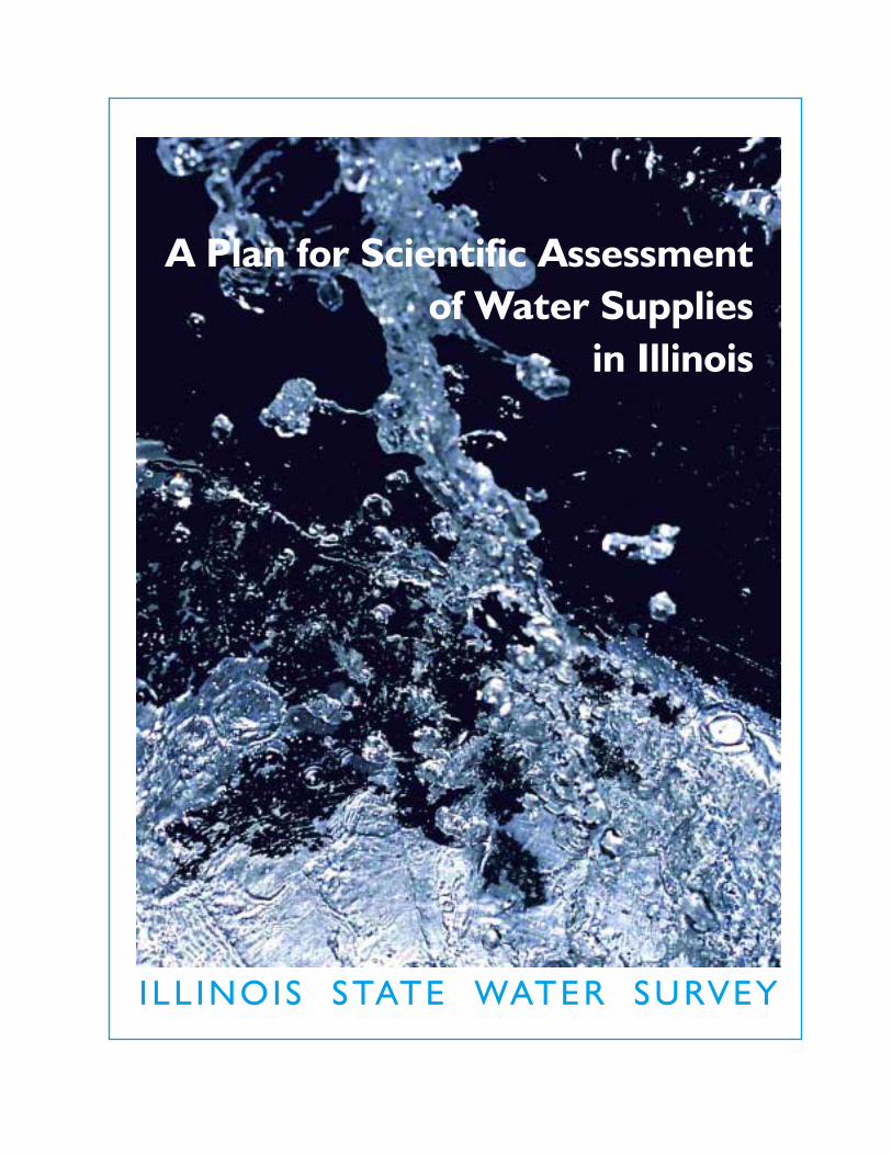
I LL INOIS STATE WATER SURVEY
A Plan for Scientific Assessmentof Water Supplies
in Illinois

Riv
er
Illino
is
Mis
sis
sip
pi
Riv
er
Riv
er
Illino
is
Mis
sis
sip
pi
Riv
er
St. Louis
Missouri River
Missouri River
St. Louis
Satellite images of the confluences of the Illinois, Mississippi, and Missouri Rivers during the 1988 drought and the 1993 flood.

A Plan for Scientific Assessmentof Water Supplies
in Illinois

Illinois State Water SurveyInformation/Educational Material 2001-03
George H. Ryan, Governor
Brent Manning, DirectorIllinois Department of Natural Resources
Derek Winstanley, ChiefIllinois State Water Survey
2204 Griffith DriveChampaign, Illinois 61820
http://www.sws.uiuc.edu
Contributors
Kingsley M. AllanJames R. Angel
Kathleen J. BrownMisganaw Demissie
Linda J. HascallKenneth J. HlinkaThomas R. HolmWalton R. KellyEva C. Kingston
H. Vernon KnappKenneth E. KunkelXin-Zhong Liang
Sally A. McConkeyScott C. Meyer
Debbie K. MitchellRobert W. ScottDouglas Walker
H. Allen WehrmannDerek Winstanley
Cover Photo: Derek Winstanley
Cover Design: Linda Hascall
Frontspiece: Landsat imagery courtesy of the Earth Observation Satellite Company, Lanham, Maryland.
Page iv: Modified from NIPC Strategic Plan for Water Resource Management, 2001.
Page 2: Model data were obtained from the Data Distribution Centre, Intergovernmental Panel onClimate Change (World Meteorological Organization and United Nations Environmental Progamme).
Page 2: Aerial photo courtesy of The State Journal-Register.
Page 4: Photo courtesy of The State Journal-Register.
Page 8: Municipal boundaries and county boundaries from Northeastern Illinois Planning Commission'sDigital Map of the Region; drinking water source information provided by Harza Engineering.
All uncredited photographs and maps provided by Water Survey staff.
Layout & Design: Publication Services, Inc.
10–01—Crouse—2M

The Need for Scientific Assessment of Water Supplies in Illinois
Recent projections by the Northeastern Illinois Planning Commission of population growth of one million and watershortages in the Chicago metropolitan area by 2020 are a wake-up call for action. Similar analyses and projections for therest of Illinois have not yet been made.
Water is increasingly recognized as a precious renewable resource to be managed wisely. About two thirds of Illinois’ dailywater use comes from surface waters and one third from groundwater. Wise management of water resources is necessary tocontinue to provide adequate supplies of clean water at a reasonable cost, to protect the state’s precious water resources andecosystems, to reduce conflicts, and to support economic growth. Wise management is based on sound technical informationand planning, taking into account such matters as climatic variations and change, renewable yields of surface waters andaquifers, opportunities for the conjunctive use of surface water and groundwater, and water conservation and reuse.
The mission of the Illinois State Water Survey (ISWS) is to characterize and evaluate the availability, quality, and use ofthe atmospheric, surface waters, and groundwater resources of the state and to make resulting data and information available to the public, decision makers, planners, and managers. This plan identifies studies that ISWS can conduct, incollaboration with others, to provide the technical data, information, tools, and training necessary for water supply planning and management. The plan addresses all major components of statewide water availability as part of the naturalhydrologic cycle: atmosphere (precipitation); surface waters (rivers, streams, lakes, and reservoirs); and groundwater (glacial, shallow, and deep bedrock aquifers). The plan also addresses the quality of water to the extent that the quality ofwater influences both its suitability for use and the cost to supply clean water.
The studies identified in this plan are consistent with the priorities identified in the deliberations of Governor Ryan’s WaterResources Advisory Committee and the Strategic Plan for Water Resource Management of the Northeastern Illinois PlanningCommission. The groundwater components of this plan also contribute to the requirements by the Illinois General Assemblyfor the Illinois Department of Natural Resources to prepare a plan to study the aquifers of the state (92 HR0365 and 92SR0137). However, consistent with the ISWS mission, I believe that Illinois needs a comprehensive assessment of waterresources that includes surface waters and climate variability and change, as well as groundwater. This comprehensive plan forwater supply assessment helps direct and organize ISWS programs and serves to inform constituents that the ISWS, workingwith others, stands ready to provide an improved technical basis for water supply planning and management statewide. Forthese reasons, the scope of the plan is broader than the General Assembly requested in its resolutions, and a comprehensivestatewide plan for aquifer assessment will necessitate additional input from other agencies and professionals.
It is a plan that first marshals existing data and information to identify water resources in need of immediate managementattention and then calls for the collection and analysis of new data, research, models, and training to improve permanentlythe state’s water supply planning and management capabilities. Implementing the plan will require major efforts to improveand restructure ISWS data collection, management, and delivery systems, and modeling capabilities.
The plan does not include lists of ongoing projects and services at ISWS but rather identifies complementary and supplementary projects that can be implemented with additional resources and sustained effort over many years. Buildingon existing projects and implementing the plan in a phased approach can lead to improved operational water supplyplanning and management in the short-term and improved planning and management on the decadal time scale.However, continuation of existing funds and projects will be adequate to implement only a fraction of the plan in a timely manner. Clearly, the rate and order of implementation of the plan will depend on levels and sources of funds. Iplan to work with state, federal, county, and local government officials and other professionals to coordinate and integrate relevant programs, set priorities, and seek funds to implement the plan. In addition to preparing and disseminatingdata and project reports on an ongoing basis, I will prepare an annual report that summarizes the progress made each year,whatever the level and sources of funding. I will also update the plan every three years.
I thank members of the Illinois State Water Plan Task Force, the Governor’s Water Resources Advisory Committee, stateagency officials, and other water resources experts for their reviews of an earlier draft and their comments and suggestionsfor improvement.
Derek WinstanleyChief, Illinois State Water Survey
Champaign, October 2001
PREF
AC
E
iii
Derek Winstanley

Mississippi
Lake
Mich
igan
Tenn
essee
Missouri
Illino
is
Ohio
Miss
issip
pi
Yello
wsto
neArkansas
Platte
Red
Atchafalaya
AtlanticOcean
Gulf of Mexico
IllinoisBasinMajor Rivers
The Mississippi/Atchafalaya River drainage basin.
ILLINOIS
Shortages
LakeMichigan
Surpluses
LAKE
COOK
DUPAGE
WILL
KANE
MCHENRY
Projected water shortages and surplusesin northeastern Illinois for the year 2020.
iv

Demand for water in Illinois is increasing, and watershortages in the Chicago metropolitan area havebeen projected. There are, however, limits to theavailability of clean water at a reasonable cost. Limitsto water availability are imposed by a number of factors including droughts, legal requirements tomaintain minimum flows in rivers and streams, waterrecharge rates, and a decree of the United StatesSupreme Court limiting withdrawal of water fromLake Michigan. In addition, the specter of regionalclimate change could pose the greatest threat toIllinois water supplies over the long term: some projections show the possibility of persistent floods,whereas other projections show persistent droughts.
Additional sources of water do exist and can betapped, but the cost of providing clean water increases with the necessity of water treatment, storage, and distribution, and the mitigation ofimpacts of new withdrawals on existing water supplies.Long lead times also are needed to construct majorwater projects. Unless the water supplies of Illinois areplanned and managed in a comprehensive, regional,and visionary manner—based on the concept ofrenewable water supply capacity—water shortagescould soon occur in some parts of the state. Watersupply planning and management should be based onimproved understanding and prediction of water supply and demand, and risk assessment.
The goal of this plan is to provide a framework forIllinois State Water Survey (ISWS) water supply programs and to document those studies that ISWS,working with others, needs to conduct to provideIllinois with comprehensive technical data and information, models, and training for water supplyplanning and management.
The following are the main tasks described in the plan:
➤ Collaborate with other organizations to coordinate andintegrate relevant programs, set priorities, plan activities,conduct studies, and seek additional resources.
➤ Assemble, archive, digitize, analyze, and synthesizeexisting data.
➤ Determine areas of possible water shortages as a basisfor setting priorities.
➤ Evaluate the quantity and quality of water resourcesthroughout the state as they relate to water supply.
➤ Provide yield estimates for major aquifers and surface waters under variable and changing climaticconditions.
➤ Identify critical data gaps and conduct field studies togather additional data and monitor the state’s waterresources.
➤ Evaluate opportunities for water conservation andreuse.
➤ Interpret and apply technical and economic data toassist and train water resource planners and managers.
➤ Develop and improve methods and models to evaluatewater resources.
➤ Develop new quality-assured databases and anInternet-based decision support system to make dataand models easily available for application by otheragencies, professionals, and the general public.
The rate and order of implementation of these studieswill depend upon the level and sources of funds andpriorities and upon collaborative efforts with otherorganizations. Existing resources are addressing many ofthese topics, but resources are limited so progress willbe slow. A major infusion of new resources is needed fortimely implementation of the studies described.
ABS
TRA
CT
v

Oh io
River
Major AquifersEast St. Louis
Major Watersheds and Rivers
1971-2000 Annual Average Precipitation (inches)
36
48464442
40
38
Chicago
Mis s iss ipp i River
Regional variability of water resources in Illinois.

ABSTRACT v
INTRODUCTION 2
FACTORS CONSIDERED IN DEVELOPING THE PLAN 4
GOAL 6
Strategies 6
SCIENTIFIC STUDIES 7
•1•Water Supply and Demand Projections 7
•2•Surface Water Supplies and Quality 8
•3• Groundwater Supplies and Quality 12
•4• Understanding and Predicting the Hydrologic Cycle and Water Resources 16
•5• Reporting of Water Use 19
•6• Comprehensive Water Supply Planning and Management 20
CONTACTS AT THE ILLINOIS STATE WATER SURVEY 22TA
BLE
OF
CO
NT
ENT
S
1
Based upon consideration of relevant factors, this plancontains an overall goal of supporting water supplyplanning and management in Illinois. The plan identifies Illinois State Water Survey (ISWS) strategies to achieve that goal with associated prod-ucts and outcomes. Section 1 addresses water supplyand demand projections; Section 2, surface water supplies and quality; and Section 3, groundwater supplies and quality. Section 4 focuses on the understanding and prediction of the hydrologic cyclein Illinois; Section 5, the reporting of water use; andSection 6, comprehensive water supply planning andmanagement. Because the components of the hydrologic cycle are intrinsically linked, there aresome necessary and unavoidable overlaps among sections. A list of ISWS contacts also is provided.
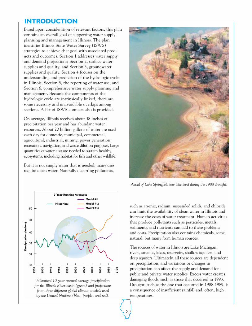
On average, Illinois receives about 38 inches of precipitation per year and has abundant waterresources. About 20 billion gallons of water are usedeach day for domestic, municipal, commercial, agricultural, industrial, mining, power generation, recreation, navigation, and waste dilution purposes. Largequantities of water also are needed to sustain healthyecosystems, including habitat for fish and other wildlife.
But it is not simply water that is needed: many usesrequire clean water. Naturally occurring pollutants,
such as arsenic, radium, suspended solids, and chloridecan limit the availability of clean water in Illinois andincrease the costs of water treatment. Human activitiesthat produce pollutants such as pesticides, metals, sediments, and nutrients can add to these problems and costs. Precipitation also contains chemicals, somenatural, but many from human sources.
The sources of water in Illinois are Lake Michigan,rivers, streams, lakes, reservoirs, shallow aquifers, anddeep aquifers. Ultimately, all these sources are dependenton precipitation, and variations or changes in precipitation can affect the supply and demand for public and private water supplies. Excess water createsdamaging floods, such as those that occurred in 1993.Drought, such as the one that occurred in 1988-1989, isa consequence of insufficient rainfall and, often, hightemperatures.
INTRODUCTION
50
45
40
35
Pre
cipi
tati
on
(inc
hes)
32
30
1900
1920
1940
1960
1980
2000
2020
2040
2060
2080
2100
Model # 2
Model # 3
10-Year Running Averages
Model #1
Historical
Historical 10-year annual average precipitation for the Illinois River basin (green) and projections
from three different global climate models used by the United Nations (blue, purple, and red).
Aerial of Lake Springfield low lake level during the 1988 drought.
2

Water is usually in motion, and scientists use thehydrologic cycle to study the flow of water betweenthe atmosphere, soils, vegetation, rivers, lakes, aquifers,oceans, and its return to the atmosphere. These components are linked and a systems approach is thusneeded to understand and predict how these componentsinteract and to provide a basis for comprehensive waterresources planning and management.
Surface waters, soil moisture, and shallow aquifersrespond fairly quickly to variation in precipitation:rainfall recharges the water supplies in rivers, lakes,reservoirs, and shallow aquifers; lack of rainfall causesthese water supplies to dry up. In a relative sense, theserapid response systems have fast recharge rates measured in terms of days or years. Deep aquifers aredifferent in that they contain water that is thousandsor, in some cases, tens of thousands of years old. Theseaquifers are slow response systems with slow rechargerates. Given an equal amount of water in two aquifers,larger amounts of water can be withdrawn safely fromthose aquifers that have faster recharge rates.
Water supply managers need data and information onprecipitation amounts, recharge rates, and other variables to determine available quantities of water fordesign of reservoirs, flood controls, well fields, andwater distribution systems. This information is also
necessary to protect the precious water resources of thestate from overuse, depletion, and contamination.
This plan emphasizes comprehensive regional assessments of renewable water supply capacity commensurate with the scientific data needs for comprehensive regional water supply planning andmanagement. Consequently, the scope of the plan isnecessarily broad. Regional assessments will be basedon watersheds, aquifers, and/or groups of counties.More detailed studies will be conducted at the countyand/or local levels. The time scale for water supplyplanning and management must extend over decades,commensurate with the long lead times needed forinfrastructure development and with the dimensions ofpossible regional climate change.
The rate and order of implementation of the studieswill depend upon the level and sources of funds, priorities, and upon collaborative efforts with otheragencies such as the Illinois State Geological Survey,Office of Water Resources, Illinois EnvironmentalProtection Agency, and United States GeologicalSurvey. Existing resources at ISWS address many ofthese topics, but resources are limited and progresswill be slow. A major infusion of new resources isneeded for timely implementation of the studiesdescribed.
The hydrologic cycle.
3
FACTORS CONSIDERED IN DEVELOPING THE PLAN
A number of developments, issues, and trends inIllinois, the Nation, and the world influence waterresources and the need for water resources studies inIllinois. These factors are identified below.
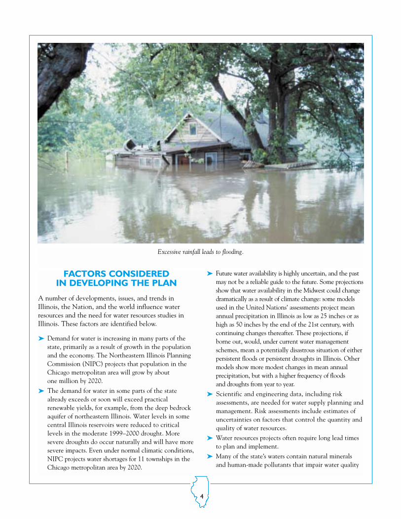
➤ Demand for water is increasing in many parts of thestate, primarily as a result of growth in the populationand the economy. The Northeastern Illinois PlanningCommission (NIPC) projects that population in theChicago metropolitan area will grow by about one million by 2020.
➤ The demand for water in some parts of the statealready exceeds or soon will exceed practical renewable yields, for example, from the deep bedrockaquifer of northeastern Illinois. Water levels in somecentral Illinois reservoirs were reduced to critical levels in the moderate 1999–2000 drought. Moresevere droughts do occur naturally and will have moresevere impacts. Even under normal climatic conditions,NIPC projects water shortages for 11 townships in theChicago metropolitan area by 2020.
➤ Future water availability is highly uncertain, and the pastmay not be a reliable guide to the future. Some projectionsshow that water availability in the Midwest could changedramatically as a result of climate change: some modelsused in the United Nations’ assessments project meanannual precipitation in Illinois as low as 25 inches or ashigh as 50 inches by the end of the 21st century, withcontinuing changes thereafter. These projections, ifborne out, would, under current water managementschemes, mean a potentially disastrous situation of eitherpersistent floods or persistent droughts in Illinois. Other models show more modest changes in mean annual precipitation, but with a higher frequency of floods and droughts from year to year.
➤ Scientific and engineering data, including risk assessments, are needed for water supply planning andmanagement. Risk assessments include estimates ofuncertainties on factors that control the quantity andquality of water resources.
➤ Water resources projects often require long lead timesto plan and implement.
➤ Many of the state’s waters contain natural mineralsand human-made pollutants that impair water quality
Excessive rainfall leads to flooding.
4

and either limit water availability or increase the costof supplying clean water.
➤ The availability and quality of water varies regionally,posing challenges in meeting local and regional waterdemands. It is not known how much water can bewithdrawn safely from many aquifers.
➤ The flows of surface waters and groundwater are linkedand need to be studied and managed conjunctively.
➤ Estimates of water use are often quite inadequate, asmany major uses are not reported.
➤ The geographical extent of watersheds and aquifers donot coincide, and political boundaries do not coincidewith watersheds or aquifers.
➤ Withdrawal of water from Lake Michigan is set bydecree of the United States Supreme Court and byagreement with other states and Canada. The allocation is almost fully used and is unlikely to beincreased in the near future.
➤ Illinois does not have updated statewide or regionalwater plans for the efficient and effective managementof water supplies.
➤ Technical data and models needed for water supplyplanning and management are often outdated, inadequate, or nonexistent.
➤ Management of the state’s water supplies is fragmentaryand decentralized.
➤ State laws permit reasonable use of water resources, butthe courts often determine what is reasonable and resolveconflicts. Water withdrawals typically are not evaluatedbased on cumulative impacts or renewable yields.
➤ Weaknesses identified in current water laws relate to theprotection of minimum instream flows, drought emergencies, and renewable yields from surface waters and aquifers. Various advisory bodies have recommendedstrengthening laws to protect minimum instream flowsand groundwater resources and to improve drought management.
A lack of rainfall parches the soil.
5
The following strategies will achieve this goal:
➤ Collaborate with other organizations andprofessionals to coordinate and integrate relevant programs, set priorities, plan activities, conduct studies, and seek additionalfunds.
➤ Assemble, archive, digitize, analyze, and synthesize existing data, including appropriatedata from neighboring states.
➤ Incorporate estimates of uncertainty andrisk in water supply assessments.
➤ Provide yield estimates for major aquifersand surface waters under variable andchanging climatic conditions, including aworst drought scenario.
➤ Determine areas where water shortagesare likely to be most critical over the next20 years.
➤ Establish databases and models of sufficientresolution and accuracy for regional studies,which can be enhanced for local studies.These databases will include improvedreporting of water use.
➤ As improved geological and hydrologicaldata and models become available, usethese in the development of improvedwater resources assessments.
➤ Identify critical data gaps and conduct fieldstudies to gather additional data, and monitor the state’s water resources todetect temporal trends in water supplies,water quality, and water use.
➤ Work with and train water supply plannersand managers to interpret and apply scientific,engineering, and economic data to assist inwater supply planning and management,including water conservation and reuse.
➤ Develop a decision support system on theInternet that presents and integrates databases and models for climate, watersheds, rivers, lakes, reservoirs, aquifers,and water use that can be readily accessedand used for any desired watershed, aquifer,geographical region, or political unit in Illinois.
➤ Provide regular updates of databases, models, and reports, and an annual summary of progress.
GOAL
The goal of this plan is to provide a framework for ISWS water supply programs and todocument those studies that ISWS, working with others, needs to conduct to provideIllinois with comprehensive technical data and information, models, and training forwater supply planning and management.
Strategies
6

7
• 1 •Water Supply and Demand Projections The most important requirements in water supplyplanning and management are to know how muchwater is required over a period of time, the qualityof water needed, and the water supply options available. Decisions then can be made on how tomeet or reduce demand. Projections of water supplyand demand inevitably include significant uncertainties, and the expression of uncertainties infuture projections provides a basis for waterresources planners and managers to conduct riskassessments and to plan for the future.
1.i. Preliminary Statewide Estimates of Water Supply and DemandIssue. Increasing withdrawal of water from streams,rivers, reservoirs, lakes and aquifers threatens toexceed local water availability in some parts ofIllinois, yet resources for scientific analysis of wateravailability and water resources management are limited. Cost-effective expenditure of limited fundswill be facilitated by first conducting a coarse,statewide comparison of water availability and demandin order to identify priority areas for detailed analysis.
Activities. To accomplish this goal, the state will be subdivided into study units, and estimates ofstreamflow yield and groundwater availability will be developed for each study unit. A preliminary estimateof overall water availability will be provided for eachstudy unit for comparison with current and projectedwater demand. Future water demand will be projectedon the basis of present per-capita demand and economic and population projections.
Groundwater availability and streamflow yield will betreated somewhat differently in this prioritizationstudy. For each study unit, groundwater availabilitywill be estimated from available aquifer mapping andpublished estimates of natural recharge to theseaquifers. Within a study unit, the upper limit on theamount of groundwater available from an aquifer willbe the product of the recharge rate and the aquifer
area within that study unit; actual well field yield willbe less than the natural recharge rate. Streamflowyield is the amount of streamflow available to supportall instream and offstream uses. A critical need is todefine flow frequencies for various stream locationsthroughout the state. The criteria needed to identifypotential regions of shortages and to prioritize regionsfor further study can be established by comparing thepotential yield to current and/or future water demand.
Products. Preliminary statewide estimates of surfacewater and groundwater availability and waterdemand will be provided. A map illustrating theratio of projected water demand to water availabilitywill be developed and published for each study unit.
Outcome. Resource analysts and managers will beable to use the data to focus limited resources ondata collection, scientific analysis, and managementin areas where projected water demand exceeds, orthreatens to exceed, water availability. Study unitshaving the highest proportion of projected demandto overall water availability will be given priority forfurther in-depth study.
<11-1011-5051-200201-500601-2000>2000
Low Flowscubic feet per second
LakeMichigan
Average annual 2-year, 7-day low flows.
SCIENTIFIC STUDIES
8
•2•Surface Water Supplies and Quality
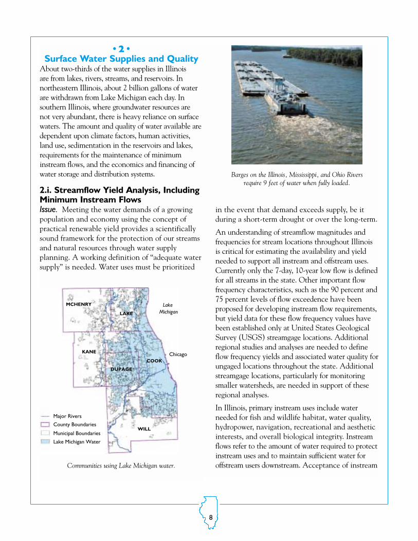
About two-thirds of the water supplies in Illinois are from lakes, rivers, streams, and reservoirs. In northeastern Illinois, about 2 billion gallons of waterare withdrawn from Lake Michigan each day. Insouthern Illinois, where groundwater resources are not very abundant, there is heavy reliance on surfacewaters. The amount and quality of water available aredependent upon climate factors, human activities,land use, sedimentation in the reservoirs and lakes,requirements for the maintenance of minimuminstream flows, and the economics and financing ofwater storage and distribution systems.
2.i. Streamflow Yield Analysis, IncludingMinimum Instream FlowsIssue. Meeting the water demands of a growingpopulation and economy using the concept ofpractical renewable yield provides a scientificallysound framework for the protection of our streamsand natural resources through water supply planning. A working definition of “adequate watersupply” is needed. Water uses must be prioritized
in the event that demand exceeds supply, be itduring a short-term drought or over the long-term.
An understanding of streamflow magnitudes and frequencies for stream locations throughout Illinoisis critical for estimating the availability and yieldneeded to support all instream and offstream uses.Currently only the 7-day, 10-year low flow is definedfor all streams in the state. Other important flow frequency characteristics, such as the 90 percent and75 percent levels of flow exceedence have been proposed for developing instream flow requirements,but yield data for these flow frequency values havebeen established only at United States GeologicalSurvey (USGS) streamgage locations. Additionalregional studies and analyses are needed to defineflow frequency yields and associated water quality forungaged locations throughout the state. Additionalstreamgage locations, particularly for monitoringsmaller watersheds, are needed in support of theseregional analyses.
In Illinois, primary instream uses include water needed for fish and wildlife habitat, water quality,hydropower, navigation, recreational and aestheticinterests, and overall biological integrity. Instreamflows refer to the amount of water required to protectinstream uses and to maintain sufficient water for offstream users downstream. Acceptance of instream
Major Rivers
County Boundaries
Municipal Boundaries
Lake Michigan Water
Lake Michigan
Chicago
WILL
KANE
COOK
MCHENRY
LAKE
DUPAGE
Communities using Lake Michigan water.
Barges on the Illinois, Mississippi, and Ohio Rivers require 9 feet of water when fully loaded.

9
flows as a legitimate water use, with rights similarto other water uses, is important to be able to provide protection for instream uses. To date, protection of the stream environment in Illinoishas focused on water quality. But there is growingrecognition that water quantity is integral to waterquality and river health.
Activities. Building on existing designations,streams and watersheds with the highest level ofuse will be identified. An inventory of streamfactors will be developed for use in identifyingboth regions of intense use and potential conflicts in use. These factors include waterwithdrawals and diversion, biological significance, water quality, waste assimilation,commercial navigation, recreational use,hydropower, and aesthetic value.
Existing and allocated offstream water uses will beidentified and compared with streamflow yield.For most streams in Illinois, the quantity of waterneeded for instream uses has not been identifiedand will require substantial future study. Surrogatevalues of instream flow requirements, such as the7-day, 10-year low flow, 90 percent flow duration,etc., will be used to identify streams/regions ofpotential shortage. Alternative approaches fordefining shortages and the adequacy of the watersupply will be investigated. Streams/regions willbe identified where streamflow yields are currently inadequate to provide all existing and/or allocateduses using the surrogate estimates of instreamflow. In addition, areas with potentially largeincreases in water use will be evaluated for theirpotential future impacts on water quality andinstream uses.
Products. Instream uses will be identified. Aninventory will be developed that lists streams,rivers, lakes, and watersheds having the greatestpotential for water use conflicts and shortages basedon surrogate levels of instream flow requirementsand water quality. Basic data will be collected andanalyzed to refine estimates of water availability andestablish a defensible criterion for renewable yields.
A range of flow frequency characteristics will beprovided. Reports and Internet databases on streamflows, water uses, and streams/regions ofpotential shortage will be produced.
Outcome. Resource analysts and managers willbe able to use the inventory to focus limitedresources on protection and restoration ofstreams with the greatest potential for watershortages and water-use conflicts. Aquatic habitat quality and abundance will be able to be linked to return periods, and risk assessments can be performed.
2.ii. Drought Assessment, Preparation, and ManagementIssue. Surface water supplies are particularly vulnerable to potential water shortages duringdrought periods. The practical renewable yield froma surface water source is dependent upon both theflow characteristics of the river or stream and thevolume of raw water storage made available throughreservoirs that store water during high flow periods.
LakeMichigan
Locations
<1 mgd1-10 mgd10-50 mgd>1000 mgd
Surface Water WithdrawalsMillions of gallons per day
Groundwater Wells
Community water supplies.

10
In certain locations, yields from surface watersources also can be manipulated to meet demandduring low flow and drought periods by conjunctiveuse of surface water and groundwater.
Surface waters are the source of most public watersupplies in southern and central Illinois, both fromdirect withdrawals from streams and, more commonly, through reservoirs formed by streamimpoundment. During drought conditions, it isvital to monitor both stream and reservoir waterlevels. Streamflow data on larger rivers and reservoirs are generally available to evaluate thewater supply potential and drought status for manylarger public water supply systems in the state—forexample, Rend Lake—but data to evaluate smallerpublic systems often are lacking. During the droughtof 1999–2000, potential water shortages threateneda number of these communities. Only a few of thesereservoirs have continuous monitoring of water levels or inflow. The current monitoring practice iswholly inadequate to provide information criticalfor decision-making during drought periods.Detailed water level and inflow data also are neededto develop water budgets and to assess yields fromthese reservoirs for planning purposes and droughtpreparation.
For water supply reservoirs, additional data related to volume, sedimentation rates, and evaporation ratesduring drought conditions also are sorely needed forrisk assessment, long-term planning, and droughtmanagement. Volumetric measurements are availablefor only a few water supply reservoirs, and estimates ofvolume are often grossly inaccurate. Regular sedimentsurveys also need to be conducted approximatelyevery 10 years to monitor changes in volume. Theseare necessary for long-term planning and vital fordrought planning and estimation of critical draw-downs and possible water shortages. In addition toproviding quantitative information on surface waterresources, the sedimentation data can be used to evaluate regional sediment-delivery rates. Evaporationlosses represent a significant percent of the gross yieldfrom a reservoir, up to 25 percent during droughts,and estimates of this fundamental process are crude.
Activities.1. Identification of Drought-prone Communities.Drought-prone community water supplies will beidentified and prioritized using published datacomparing current water withdrawals and 50-yeardrought yields. Once these communities are identified, a drought plan will be proposed foreach community that sets limits on the safe yield,identifies cumulative rainfall deficits that triggerwater conservation measures, and suggests otheractions to reduce the risk of water shortages.
2. Reservoir Water-Level Monitoring. A networkof continuous, real-time, water-level monitoring stations will be implemented at selected reservoirsused for water supply. Real-time data collection willprovide valuable information during drought periods. Long-term data collection will provideinformation for development of water budgets andresource planning. Continuously recording staffgages will be installed over a 5-year period. Afterthis period, the program will continue data collection, equipment replacement, and rehabilitation.
3. Reservoir Sedimentation Monitoring.A long-term program of reservoir sedimentationmonitoring will be established. Reservoirs
Instruments measure precipitation, wind, soil moisture, temperature, and humidity.

11
throughout the state will be surveyed initially andthen re-surveyed on a rotational basis. Reservoirsediment surveys will be conducted continuouslythrough summer and fall as weather permits.Approximately five lake surveys will be conductedeach year. Public water-supply reservoirs will havetop priority for surveys, particularly those reservoirs identified as being at-risk duringdroughts.
4. Stream Monitoring. New gages will be addedto the Illinois Streamgage Network operated byUSGS. New streamgage locations on smallerwatersheds will be identified, with priority ongages placed near reservoir systems that are mostat-risk for drought impacts.
5. Reservoir Evaporation Monitoring. A networkof seven long-term evaporation-monitoring stationswill be established at selected reservoirs acrossIllinois. Weather stations at reservoirs will measurethe meteorological parameters required to accuratelycalculate evaporation from the water surface. Datacollected at these stations will be used to establishrelationships between water surface evaporation andparameters routinely measured at standard weatherstations and to develop models that simulate theeffects of evaporation on reservoir capacity. Long-term monitoring also will provide informationto track climate change impacts on evaporation, andstatistical analyses of data sets will assess water reliability.
6. Hydrologic Analysis. From historical data andthe data collected above, improved methodologieswill be developed for the assessment and design ofyields for water supply systems. This includes thedevelopment of regional models for estimatingdrought streamflow conditions for existing watersupply systems as well as ungaged stream locationsthroughout the state. Worst drought scenarios willbe defined. Approaches for drought forecasting
and management strategies during drought conditions also will be examined.
Products. Reports and databases that identifydrought-prone communities will be prepared, disseminated, and made available on theInternet. Assistance will be provided to at-riskcommunities and, with their cooperation, watersupply and drought management plans will beprepared. Continuous, real-time water levels onstreams and reservoirs will be measured, and datacollections and analyses will be provided on theInternet and in reports. Real-time monitoringwill provide critical information for assessingpotential drought and flood conditions and forsystem management during these extremeevents. Data for reservoir budget analysis andlong-term data sets will provide information forimproved water supply management. Data collections and data analyses of estimated volume losses for measured and unmeasuredreservoirs will be provided in reports and on theInternet. Data from streamgages will be used fordeveloping better regional models that estimateflow characteristics on ungaged streams.
Outcome. Communities will be better able toplan and manage water supplies for drought emergencies, thus minimizing the risk of watershortages. Water supply planners and managerswill be better able to track the water supply statusof reservoirs during droughts, develop water budget and reservoir models to forecast droughtimpacts on individual water supplies, and analyzethe adequacy of systems. High-flow data also canbe used to improve regional relationships of flooddischarge and frequency. Assessment of appropriate options for rehabilitating reservoirsand maintaining adequate water supplies will bebased on data and knowledge of the rate of sedimentation.

12
•3•Groundwater Supplies and Quality
Groundwater is withdrawn for large public, industrial,and commercial purposes from three principal categories of aquifers in Illinois: (1) unconsolidatedsand-and-gravel aquifers contained within the glacial drift, (2) shallow bedrock aquifers, and (3)deep bedrock aquifers. The amount of groundwaterthat can be withdrawn safely varies tremendouslyfrom aquifer to aquifer, as does the quality of thewater. In addition, thousands of private wells tapwater in the shallow aquifers. Withdrawals ofgroundwater in Illinois average about 1 billion gallons per day and serve about a third of Illinois’population.
Many factors influence the practical renewableyield of aquifers and water quality, and these factors have not been quantified well enough topermit an accurate statewide assessment ofrenewable yields and water quality. Records ofaquifer characteristics are needed to establish theaquifers’ physical and hydraulic properties,groundwater withdrawals, spatial and temporalchanges in groundwater levels and groundwaterquality, and to provide input to mathematicalcomputer models. However, comprehensive digitized records of the hydrologic, hydraulic,and water quality properties of the state’saquifers either do not exist or need to be updatedand made more accessible: agencies have theirown databases, and much ISWS data remain to
be digitized. The need for improved databases isrevealed every time a groundwater flow model orstatistical assessment of aquifer properties is conducted.
High-capacity wells also may have adverse impactson nearby wells and the base flows of rivers andstreams, regardless of whether or not the practicalrenewable yield of the source aquifer is exceeded.Unfortunately, modern computer flow models thatcan simulate aquifer conditions and calculaterenewable yields and the impacts of new wells onexisting wells do not exist for Illinois aquifers. Inaddition, adverse impacts are not well defined.
3.i. Regional Aquifer Characterizationand MonitoringIssue. For decades, the ISWS has collectedimportant groundwater data for many of Illinois’major regional aquifer systems. However, theISWS does not have comprehensive, easily accessible digital records of the spatial and temporal distribution of many key aquifer characteristics. Data resolution is very inconsistent across the state, many data gaps exist, and many data sets need to be updated.
Activities. Existing data will be assembled andorganized to characterize the shape, depth, physical(hydraulic) properties, boundary conditions, ratesof recharge under normal and drought conditions,
LakeMichigan
Limit of data
400 400
1000
2000
1000
High concentrations (mg/L) of dissolved solids limit the use ofwater in southern parts of the deep sandstone aquifer.
140
100
120
80
40
60Cl (
mg/
L)
20
01950 1960 1970 1980 1990 2000
Change in chloride concentrations in four municipal wells(<200 feet deep) in Kane County.

13
hydraulic heads, locations of wells and groundwaterwithdrawals, and water quality in the state’s majorregional aquifers. Existing ISWS databases will beupdated with additional data collected through themultitude of projects previously conducted byISWS and other scientists. New databases will becreated from data mined from ISWS paper files andpublications. A comprehensive literature reviewwill be conducted to glean data from previousISWS investigations. Original well-constructionrecords will be scanned and digitized. Priority willbe placed on those aquifers most in need of studyand management attention, based on the use-to-yield analysis discussed previously. A preliminary list of the state’s major aquifers is provided below.
➤ The “deep bedrock” aquifer system of northeasternIllinois (Cambrian-Ordovician System)
➤ The Mahomet aquifer of east-central Illinois fromIndiana to the Illinois River
➤ The shallow sand-and-gravel and bedrock aquifersin northeastern Illinois
➤ The Sankoty aquifer of Lee and WhitesideCounties and from Hennepin to Washington
➤ The alluvial aquifer systems along the MississippiRiver
➤ The shallow dolomite in Kankakee, Iroquois,Will, and Cook Counties
➤ The Saline Valley in Saline and GallatinCounties
➤ The alluvial system along the Wabash RiverValley
➤ The alluvial system of the Lower Illinois Riverfrom Beardstown to Alton
➤ The alluvial system of the Rock River fromWisconsin to Sterling
➤ The alluvial system of the Kaskaskia River Valley➤ The alluvial system of the Cache River Valley➤ The alluvial system of the Embarras River Valley➤ The “ridged-drift” aquifer near Taylorville
Products. Data will be assimilated, disseminated,and made available in reports and via the
Internet. Existing ISWS databases to be updatedfor documentation of water use, aquifer hydraulicproperties, groundwater levels, and groundwaterquality include the Private Well Data Base, thePublic-Industrial-Commercial Survey, and theIllinois Water Inventory Program. Improved linksto other databases will be established (e.g., IllinoisState Geological Survey geological records andIllinois Environmental Protection Agency andIllinois Natural History Survey water qualityrecords) and efforts strengthened to minimizeoverlap and duplication. Guidelines for the definition of adverse impacts will be provided.
Outcome. Scientists, analysts, and decision makerswill be able to access a wealth of groundwater datastatewide. These data will be useful as data inputto the development of regional and local aquifermodels. The outcome will be more scientific andreliable water supply planning and managementacross the state and conflict resolution.
3.ii. Preliminary Groundwater ModelingIssue. Groundwater flow models are needed todetermine renewable yields from aquifers, capturezones of wells, water quality, and to evaluate the
Drilling a well to tap groundwater.

14
impacts of water withdrawals. The ISWS hasdeveloped flow models for only a few aquifers, andthese models are not up to date. Flow models needto be constructed and/or updated for all the majoraquifers in the state.
Activities. As data are assembled and organized onIllinois’ high priority aquifers, simple groundwatermodels will be constructed to provide estimates of groundwater availability (practical renewableyield) and water quality for that aquifer. Existingmodels will be evaluated, updated, and used asappropriate. Priority will be placed on thoseaquifers most in need of study and managementattention, based on the use-to-yield analysis discussed previously.
Products. Estimates of groundwater availability,with uncertainty estimates, and water qualitycharacterizations will be provided for each majoraquifer in Illinois. For those aquifers experiencingpotential water-use conflicts, a computer flowmodel will be constructed such that estimates ofwell interference on groundwater levels andstreamflows can be provided.
Outcome. These models will provide tools for waterplanners and managers to assess regional groundwateravailability, water quality, and impacts of withdrawals.In tandem with surface water assessments,
alternatives for new water-resource developments toalleviate water shortages can be examined. In addition, such models can provide important feedback to help identify additional data needed toreduce model uncertainty. This will form the basisfor additional new data collection efforts.
3.iii. Field StudiesIssue. Preliminary groundwater models will contain a fairly high degree of uncertainty becausespecific field studies have not been conducted togather data for model development and validation.However, these models will provide a basis for planning aquifer-specific field studies.
Activities. Based on model uncertainties andpriority aquifers, field studies will be conductedto collect new data through short-term samplingand long-term monitoring. Priority will be placedon those aquifers most in need of study and management attention, based on the use-to-yieldanalysis discussed previously. Such new data collection activities will include:
➤ Improving estimates of groundwater recharge andestimates of the impacts of climate variability andchange on recharge.
➤ Determining surface water/groundwater interactionsunder normal and drought conditions.
Irrigation of crops uses large quantities of groundwater in some parts of Illinois.

15
➤ Determining aquifer hydraulic properties inuntested areas.
➤ Improving geologic maps to provide better estimatesof aquifer physical properties.
➤ Collecting water-level data for the creation ofpotentiometric surface (water-level) maps.
➤ Collecting water samples to characterize waterquality.
Products. Databases, graphics, and maps forIllinois’ major aquifers, providing improved spatialresolution of aquifer physical, hydraulic, andchemical properties, will be produced. These products will be disseminated in reports and madeavailable via the Internet.
Outcome. Improved resolution of field data willprovide input for the development of moredetailed and accurate groundwater flow modelsand for managing water-use conflicts.
3.iv. Detailed Mathematical ComputerModelsIssue. Decision makers need “living” numericalcomputer models to evaluate alternative strategiesfor resource development. Such models must becapable of a) accurately simulating hydraulic headand transport of chemicals in the aquifers, b) estimating practical renewable yields of the state’smajor aquifers, c) identifying capture zones aroundpublic water supply wells, d) identifying interferencedrawdown, and e) providing scientific input formanagement of groundwater resources.
Activities. All existing data and the results offield studies will be incorporated into detailedgroundwater flow models of the state’s majorregional aquifers. Priority will be placed on those
aquifers most in need of study and managementattention based on the use-to-yield analysis discussed previously. Models will be updated routinely as new data are collected to improvemodel calibrations and predictive capabilities.Computer flow models will be migrated to newsoftware and hardware platforms for improvedmodel performance.
Products. Computer flow models for Illinois’major aquifers, with uncertainty analysis, will beplaced on Internet-based decision support systems(see Section 6) for use by analysts in evaluatingwater management options. The flow models willinclude the transport of chemicals.
Outcome. With higher resolution data, detailed computer groundwater models can beconstructed to make more accurate predictionsof impacts of withdrawals on water levels, water quality, surface water interactions, and,ultimately, aquifer yield. Such models can beapplied to evaluate:
➤ Long-term practical renewable yields from thestate’s major aquifers.
➤ Impacts of withdrawals on the quality and quantity of the resources.
➤ Interaction between shallow groundwater suppliesand streamflows.
➤ Options for the artificial recharge of aquifers.➤ Water use conflicts.
The overall outcome will be the protection ofgroundwater resources, the identification ofoptions for the renewable use of groundwaterresources, and the resolution of water-use conflicts.
16
•4•Understanding and Predicting the
Hydrologic Cycle and Water Resources All components of the hydrologic cycle are interdependent: precipitation affects soil moistureand surface water; soil moisture also affects precipitation and aquifer recharge; and surface watersand aquifers are interconnected. It is, therefore,appropriate and necessary to study the hydrologiccycle and water resources in Illinois as a system.Mathematical computer models provide an opportunity to simulate this system and to possiblypredict future changes of this system and waterresources in Illinois. Such a systems approach provides a scientific basis for comprehensive regionalwater supply planning and management (Section 6).
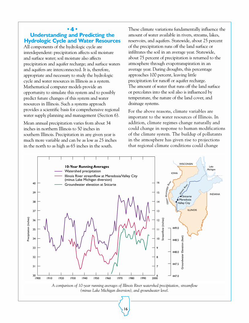
Mean annual precipitation varies from about 34inches in northern Illinois to 50 inches in southern Illinois. Precipitation in any given year ismuch more variable and can be as low as 25 inchesin the north to as high as 65 inches in the south.
These climate variations fundamentally influence theamount of water available in rivers, streams, lakes,reservoirs, and aquifers. Statewide, about 25 percentof the precipitation runs off the land surface or infiltrates the soil in an average year. Statewide,about 75 percent of precipitation is returned to the atmosphere through evapotranspiration in an average year. During droughts, this percentageapproaches 100 percent, leaving little precipitation for runoff or aquifer recharge. The amount of water that runs off the land surface or percolates into the soil also is influenced by temperature, the nature of the land cover, anddrainage systems.
For the above reasons, climate variables areimportant to the water resources of Illinois. Inaddition, climate regimes change naturally andcould change in response to human modificationsof the climate system. The buildup of pollutantsin the atmosphere has given rise to projectionsthat regional climate conditions could change
WISCONSIN
INDIANA
ILLINOIS
IOWA
MeredosiaSnicarte
Valley City
LakeMichigan
Upp
erM
issi
ssip
piRi
ver
Illin
ois Ri
ver
10-Year Running AveragesWatershed precipitationIllinois River streamflow at Meredosia/Valley City(minus Lake Michigan diversion)Groundwater elevation at Snicarte
39
40
38
15
16
14
37
36
35
Prec
ipita
tion
(inch
es)
Stre
amflo
w (
inch
es)
Gro
undw
ater
Ele
vatio
n (fe
et)
34
33
32
31
447.0
447.5
448.0
448.5
449.0
30
13
12
11
10
9
8
7
61900 1910 1920 1930 1940 1950 1960 1970 1980 1990 2000
A comparison of 10-year running averages of Illinois River watershed precipitation, streamflow (minus Lake Michigan diversion), and groundwater level.

17
dramatically due to global warming caused by anenhanced greenhouse effect. The fact that different models produce different scenarios ofclimate change points to the large scientificuncertainties that exist in projecting climatechange. Nevertheless, there are risks that climatechange, even in the next 20 years, could impactwater resources in Illinois due to changes in precipitation and temperature and to changes inthe frequencies of droughts and floods. It wouldbe shortsighted to assume that the future climateof Illinois will be the same as the present climateto which ecosystems, society, and the economyhave adapted. The risk of climate change and the possible impacts of climate change on Illinoiswater resources need to be evaluated.
4.i. Monitoring of Climate, Soil, and Land-use ChangesIssue. A 19-station array of sensors across thestate provides continuous observations of climateand soil conditions. Data from the Illinois ClimateNetwork (ICN) are becoming increasingly important to a growing number of governmental,university, private enterprise, and public users.Data are used by the Illinois State Water PlanTask Force to monitor and evaluate water and soilconditions across Illinois and to plan for droughtemergencies. For security and station longevityconsiderations, the network’s original stations wereplaced on state or university property. Increaseddemands for data often are not met because theexisting distribution of stations is not sufficientlydense.
In addition, runoff into rivers, streams, and reservoirs can be altered from present rates bychanges in land-use cover and related variableswithin a basin—for example, crops, reforestationand restoration. A better understanding of theoverall impacts of changes in these variables onwater supplies can be achieved by monitoring keyclimate, land-use, and other watershed conditionsat selected locations within a basin and thendeveloping a model to extend these analyses toother basins and other conditions.
Activities. Twelve additional ICN sites need to be installed in Illinois to provide improved waterresources data across the state. The sites need tobe equipped with weather and soil observationsensors, towers, dataloggers, weather shelters, andcommunications and other equipment.
Also, a small stream basin will be selected for intensive monitoring. One criterion for basin selection will be the availability of streamgages andreservoir water-level monitors. To represent likelywithin-basin differences in evapotranspiration andsoil moisture, four sites will be selected for routinemonitoring of, for example, upland crop, upland forest, lowland crop, and lowland forest. Each sitewill be instrumented to obtain measurements ofprecipitation, evapotranspiration, soil conditions,vegetation, and related variables. Data will be collected routinely for 10 years to establish temporalvariations in the relationship of these elements torunoff. Data will be analyzed and a model developed to simulate a water budget for the basin.Once the validity of the model is established, it can be applied to other basins.
Products. Continuous observations of weather andsoil conditions statewide, a 10-year record, and amodel of the water budget in a basin will be provided.Data sets, models, and reports will be prepared, disseminated, and made available via the Internet.
Outcome. Water supply planners and managers,weather- and climate-sensitive industries, and thepublic will be able to incorporate the data intoimproved operational models and decision making.The effects of land-use changes on water supplieswill be quantified, and the basin model will beapplied to better plan and manage water resourcesunder changing basin conditions.
4.ii. Modeling the Linked Climate/SurfaceWater/Groundwater SystemIssue. Potential future climate variability andchange pose threats to water supplies. Assessment ofthe effects of climate variability and climate changeon water resources requires data at the spatial scalesof watersheds. Watersheds feed many water supplies

18
much smaller than the resolution of global climatemodels. Therefore, the projections by these modelscannot be used directly to assess impacts on specificwater supplies. Regional climate modeling isrequired to address these issues. However, regionalclimate models are still under development, andmore research is required to improve model accuracy so that they can be applied with confidence to address water resources issues. TheISWS has initiated a regional climate modelingprogram, but limited resources restrict progress onthis very important issue.
Activities. Four major activities will be undertakento improve the usefulness of regional climate modelinformation for water resources applications.
One activity will focus on improvement of the modelthrough a sequence of model simulations of selectedhistorical events, comparisons of model results withobserved events, and identification of potentialmodel improvements to enhance model capabilitiesto simulate droughts and heavy precipitation eventsthat cause flooding. The goal will be to accuratelysimulate these events for a variety of climate conditions under which they occur. Accurate simulations of past events will increase confidence in the ability of models to project future climateextremes and climate changes.
The second task, undertaken in parallel with thefirst, will be the coupling of the regional climatemodel with surface hydrologic models to directlyproduce estimates of runoff, discharge, and infiltration.
The third task will be to link climate, surfacehydrology, and groundwater flow models to evaluate system impacts of possible climate variations and changes.
The fourth task will be to apply the linked models,embedded in a global climate model, to projectpossible future climate and water resources conditionsin Illinois.
Products. Assessments will be made of the risksand possible consequences of future climatechange on water resources in Illinois. Resultingdata sets will be disseminated in reports and madeavailable via the Internet.
Outcome. Policy makers and water supply planners will be able to use the new data on possible future water resources conditions in Illinoisto conduct risk assessments, to evaluate alternativepolicies and strategies, and to make far-sighteddecisions.
4.iii. Assessment of Climate ChangeModel ProjectionsIssue. Climate models are complex mathematicalcomputer programs that scientists use to projectpossible climate changes due to natural andhuman factors. Research groups around the worldare improving these models. However, largemodel-to-model differences in future projectionsof precipitation and temperature for Illinoisreflect scientists incomplete understanding andmodel simplifications of the global climate system.It is important to evaluate model differences andto assess the credibility of new model projections,since the climate and water resources of the 21stCentury could be significantly different fromthose of the 20th Century.
Activities. Projections of Illinois’ climates produced by different models will be assessed and their implications for Illinois water resourcesevaluated.
Products. Reports on a range of possible futureclimate conditions will be provided, along withassessments of the uncertainties of these projections. Explanations will be provided whymodels using essentially the same drivers—emissions associated with natural processes andpopulation and economic growth—produce different climate projections.
Outcome. Governments and private industrywill be able to use these projections, with interpretations and uncertainty estimates, asguidance for risk assessment in water resourcesplanning and management. The information andknowledge gained also will provide valuable guidance for the regional climate modeling activity to decide which models to use for moredetailed assessments of water resources.

19
•5•Reporting of Water Use
Water supply planning requires comprehensiveand detailed information on water withdrawals,uses, transfers, and returns. Assessment of wateravailability is fundamental, but it is equally essential that the demands on that resource bequantitatively and geographically identified. Waterwithdrawal information is necessary to developwater budgets, calculate adjustments to streamflowrecords, monitor trends in water demand, as inputto develop and calibrate hydrologic models, andresolve conflicts.
5.i. Reporting and Analysis of WaterWithdrawal, Use, Transfer, and ReturnIssue. The ISWS has a long-standing program ofwater withdrawal data collection, analysis, andreporting for surface waters and groundwater.However, more comprehensive, detailed, and precise data collection, analysis, and reporting arerequired for self-supplied users, trend analysis, integration and analysis of water returns, andaccounting of water transfers.
Activities. Building on existing data, expertise, andresources, ISWS will a) coordinate work with othergovernmental organizations to collect, archive, anddisseminate water data; b) expand current data collection activities to increase annual reportingreturn rates to approach 100 percent for major users; c) assimilate water withdrawal, use, transfer, and returndata; d) develop a coordinated, Internet-based database;e) expand and refine data quality control and quality
Fresh Water Withdrawals 1995 (MGD)
Domestic and Public Supply
Self-Supplied Industries
Livestock and Irrigation
Thermoelectric Power
Total
1450
422
2
17,100
18,974
500
183
234
11
928
1949
606
236
17,100
18,891
SurfaceWater
GroundWater Total
Source: USGS Circular 1200
Freshwater withdrawals in millions of gallons per day (mgd)from surface water and groundwater, 1995.
Electric power generation is the major use of water in Illinois.

20
assurance for the data; f) analyze consumption, returns, and inter-basin transfers; and g) provide wateruse data to communities and engineers engaged infacility design and watershed and water supply planning.
Products. Databases and reports on surface waterand groundwater withdrawals, transfers, uses, andreturns will be disseminated and made availableon the Internet.
Outcomes. Fuller accounting of water withdrawals, uses, transfers, and returns will enablewater supply planners and managers to developwater budgets, calculate adjustments to streamflowrecords, monitor trends in water demand, prioritizewater withdrawals, calibrate hydrologic models,and resolve conflicts. As a result, the state’s waterresources can be used more wisely.
•6•Comprehensive Water Supply
Planning and ManagementWater use in Illinois is largely unregulated and controlled by a market economy. Surface water andgroundwater resources are usually studied and managed separately, yet there are many opportunitiesfor the conjunctive use of these resources. To date,there is little conservation or reuse of water in Illinois,but many opportunities for doing so exist. The abovestudies will provide large quantities of quality-assureddata that must be assembled, synthesized, analyzed, andmade easily available to other agencies and the generalpublic for appropriate use.
6.i. Decision SupportIssue. The management of water resources inIllinois is complicated by the spatial and temporal
DataCollection
Data Analysisand Interpretation
DataManagement
Planning
Outcome: Water Management
Decision support for comprehensive water resources planning and management.

21
variability of water resources, climatic uncertainty,groundwater/surface water interactions, a diversityof constituent interests, social and economic considerations, and legal constraints. Wise andoptimal use of water supplies requires evaluatingoptions for and the consequences of water management policies and strategies, which cancome only from accurate, unbiased data interpreted and analyzed for water resources planners. Comprehensive water supply planning at the regional and local scales can increase efficiencies, lower costs, and ensure the futureavailability of adequate supplies of clean water at a reasonable cost.
Activities. Three major activities are identified.
1. Develop quality-assured databases, tables, graphics,and maps related to water supply (climate, surfacewater and groundwater), demand, withdrawal, use, and interbasin transfer. These databases will be compatible and constructed by geographical(watersheds and aquifers) and political units.
2. Develop and maintain an accessible, comprehensiveInternet-based decision-support system that willinclude:a. Quality-assured databases;b. Research results to address key social,
hydrologic, and economic uncertainties (e.g.,the value of nonmarket use of water, the impactof climate variations on aquifer recharge); and
c. Tested computer models for evaluating alternative hydrologic and economic strategiesfor the optimal conjunctive use of waterresources (e.g., cost minimization or net socialbenefit maximization) and water conservationand reuse.
3. Interact with local, state, and national waterresource planners to construct plausible
management scenarios and to translate data andmodel results into actionable knowledge.Provide training to regional and local officialson water supply planning and managementunder variable climatic conditions.
Products. These activities will organize dataproducts and information and disseminate theseas reports and as multimedia presentations,including models, via the Internet. Methods foranalyzing the optimal conjunctive uses of surfacewater and groundwater resources, together withwater conservation and reuse strategies, will bemade available in reports and via the Internet.ISWS will train personnel in water supply planning.
Outcomes. Comprehensive water supply planning can lead to the optimal use of limitedresources for minimum financial and environmental costs. Economic models developed by these activities will provide arational basis for determining water management strategies. Water resource plannersand managers will be able to use their trainingand the new data to design and develop water supply, treatment, and distribution projects.
Costs
Benefits
Evaluating the costs and benefits of water supply,conservation, and reuse options.
CONTACTS AT THE ILLINOISSTATE WATER SURVEY
Illinois State Water Survey2204 Griffith DriveChampaign, IL 61820-7495(217) 244-5459TDD: (217) 782-9175Fax: (217) 333-6540Web: http://www.sws.uiuc.edu
Office of the ChiefChief: Derek Winstanley, (217) 244-5459Financial & Human Resources: Joyce Changnon,
(217) 333-0448Planning & Operations: Ronald Karr, (217) 333-8885External Relations & QA/QC: Mark Peden, (217) 333-8325Geographic Information Systems: Kingsley Allan,
(217) 333-0545Library: Patricia Morse, (217) 333-4956Water & Atmospheric Resources Monitoring: Bob Scott,
(217) 333-4966
Analytical Chemistry & Technology UnitHead: Kent Smothers, (217) 333-6167Internal Analytical Services/Public Service Laboratory:
Loretta Skowron, (217) 333-4977Midwest Technology Assistance Center: Kent Smothers,
(217) 333-6167Water Analyses: Brian Kaiser, (217) 333-9234
Atmospheric Environment SectionHead: Kenneth Kunkel, (217) 244-1488Agricultural Meteorology: Steven Hollinger,
(217) 244-2939Atmospheric Chemistry: Gary Stensland, (217) 244-2522 Climate Modeling: Xin-Zhong Liang, (217) 244-6864Climate Studies: Stanley Changnon, (217) 244-0494Cloud Physics: Harry Ochs, (217) 333-4964
Mesoscale Meteorology: David Kristovich, (217) 333-7399Midwestern Climate Center: Steve Hilberg,
(217) 333-8495State Climatologist: James Angel, (217) 333-0729
Groundwater SectionInterim Head: Derek Winstanley, (217) 244-5459Groundwater Supplies: Allen Wehrmann, (217) 333-0493Groundwater Quality: Walt Kelly, (217) 333-3729 Groundwater Information: Ken Hlinka, (217) 333-8431Well Design and Rehabilitation: Bob Olson,
(217) 333-8700Well Records: Susie Dodd-Casey, (217) 333-9043
National Atmospheric Deposition ProgramHead & NADP Coordinator: Van Bowersox,
(217) 333-7873Central Analytical Laboratory: Karen Harlin, (217) 244-6413Toxics and Mercury Deposition: Clyde Sweet,
(217) 333-7191
Watershed Science SectionHead: Mike Demissie, (217) 333-4753Erosion & Sedimentation: Mike Demissie, (217) 333-4753Hydrologic Modeling: Deva Borah, (217) 244-8856Illinois River Decision Support System: Melinda Tidrick,
(217) 244-7106River Mechanics & Hydraulics: Nani Bhowmik,
(217) 333-6775Sediment Quality: Mike Machesky, (217) 333-9322Streamflow Assessment: Vern Knapp, (217) 333-4423Surface Water Information: Bill Saylor, (217) 333-0447Surface Water Supplies: Sally McConkey,
(217) 333-5482Water Quality: Gary Peyton, (217) 333-5905Watershed Monitoring: Laura Keefer, (217) 333-3468Watershed Restoration: Don Roseboom, Peoria,
(309) 671-3196Wetlands: Mike Demissie, (217) 333-4753
22

Starved Rock Lock and Dam on the Illinois River.

Illinois State Water Survey2204 Griffith Drive
Champaign, IL 61820-7495(217) 244-5459
TDD: (217) 782-9175Fax: (217) 333-6540
Web: http://www.sws.uiuc.edu