Embed Size (px)
Citation preview
A pilot GNSS timing station in
Thailand geodetic network
Thayathip Thongtan
National Institute of Metrology (Thailand)
UN/Nepal Workshop on the applications of GNSS
12 – 16 December 2016, Kathmandu
1
• The United Nations Office for Outer Space Affairs
• Survey Department of the Ministry of Land Reform and Management of Nepal
• International Committee on GNSS (ICG)
• NIMT
Acknowledgement
2
• Introduction
• NIMT timing activities
• 2017 Plans
• Conclusion
Outline
3
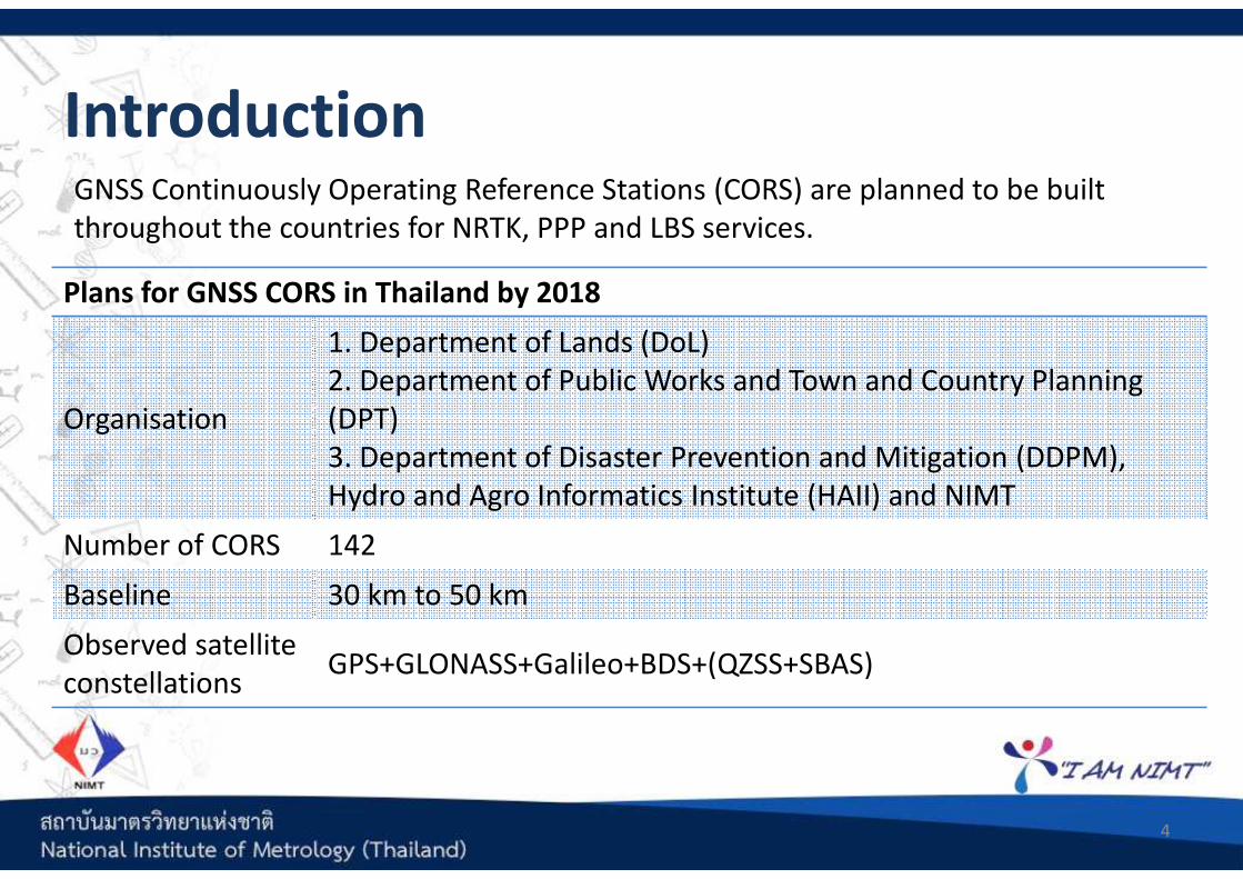
GNSS Continuously Operating Reference Stations (CORS) are planned to be built
throughout the countries for NRTK, PPP and LBS services.
Introduction
4
Plans for GNSS CORS in Thailand by 2018
Organisation
1. Department of Lands (DoL)
2. Department of Public Works and Town and Country Planning
(DPT)
3. Department of Disaster Prevention and Mitigation (DDPM),
Hydro and Agro Informatics Institute (HAII) and NIMT
Number of CORS 142
Baseline 30 km to 50 km
Observed satellite
constellationsGPS+GLONASS+Galileo+BDS+(QZSS+SBAS)
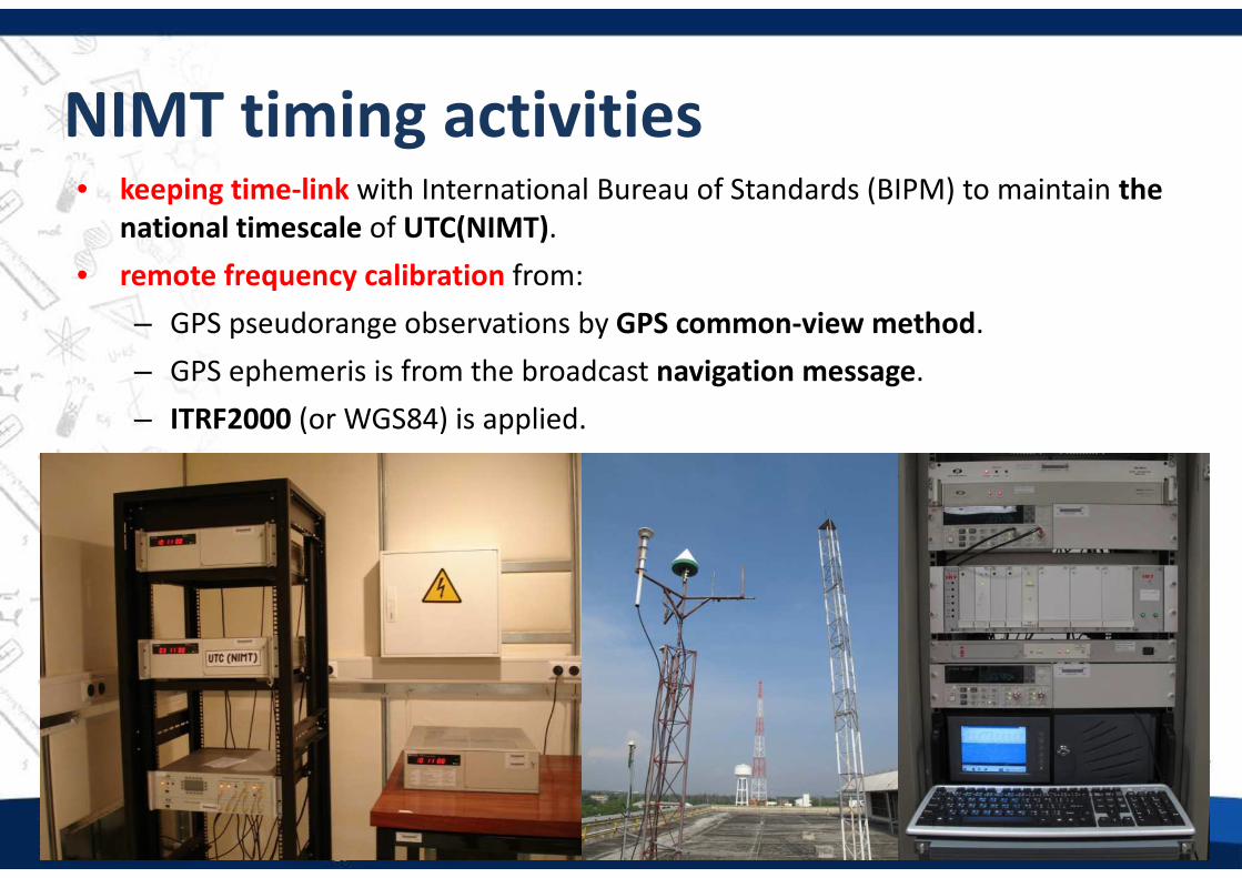
• keeping time-link with International Bureau of Standards (BIPM) to maintain the
national timescale of UTC(NIMT).
• remote frequency calibration from:
– GPS pseudorange observations by GPS common-view method.
– GPS ephemeris is from the broadcast navigation message.
– ITRF2000 (or WGS84) is applied.
NIMT timing activities
5
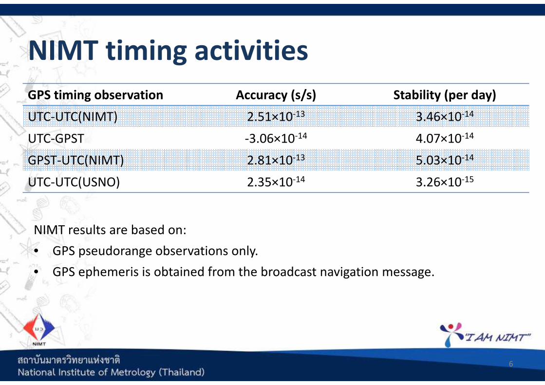
NIMT results are based on:
• GPS pseudorange observations only.
• GPS ephemeris is obtained from the broadcast navigation message.
NIMT timing activities
6
GPS timing observation Accuracy (s/s) Stability (per day)
UTC-UTC(NIMT) 2.51×10⁻¹³ 3.46×10⁻¹⁴
UTC-GPST -3.06×10⁻¹⁴ 4.07×10⁻¹⁴
GPST-UTC(NIMT) 2.81×10⁻¹³ 5.03×10⁻¹⁴
UTC-UTC(USNO) 2.35×10⁻¹⁴ 3.26×10⁻¹⁵
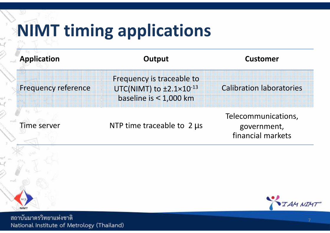
Application Output Customer
Frequency referenceFrequency is traceable to
UTC(NIMT) to ±2.1×10⁻¹³
baseline is < 1,000 km
Calibration laboratories
Time server NTP time traceable to 2 µsTelecommunications,
government, financial markets
NIMT timing applications
7
Set up two GNSS timing stations
• Equipment and software are:
– geodetic receiver (Topcon NetG5)
– choke-ring antenna (Topcon CR-G5)
– high performance tube caesium frequency standard (5071A-001)
– Bernese software
• This work is under HAII, DDPM and NIMT collaborations.
Include Active Hydrogen MASER (AHM)
• Improve the short term stability of UTC(NIMT)
• Ensemble clocks of 1 AHM and 3 high performance caesium frequency
standards.
2017 Plans: establish timing station
8
Join IGS as a GNSS timing station
• This is to obtain GNSS obtain the computed precise satellite ephemeris, clock
offsets, atmospheric delay, station coordinates and clock offsets in ITRF.
• Purposes are for :
– time comparisons
– Precise Point Positioning (PPP) determination
– quality measure improvements
2017 Plans: join IGS timing station
9
Improve NIMT timing quality measures
• Plans to improve the quality are in 3 parts:
– stability of the timescale by including an active hydrogen maser to the
timescales.
– timing accuracy by determine the error parameters (i.e. receiver internal
delay).
– national time-link accuracy by applying GNSS observations.
Determine integrity of the GNSS timing signals by
• Estimate or model other GNSS observations such as troposphere and ionosphere
delay.
• Analyse the reliability (internal and external) of the estimated parameters.
2017 Plans: improve quality measures
10

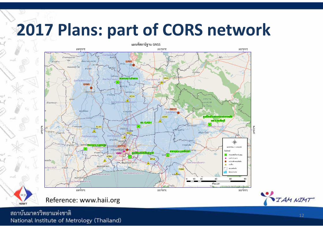
NIMT GNSS CORS is part of the GNSS CORS network of six stations under
collaborations between ministry of interior and ministry of science.
2017 Plans: part of CORS network
11
GNSS CORS by DDPM, HAII and NIMT
Number of stations 6
Main purpose Water and disaster management
GNSS CORS locations Flood risk areas along Chaopraya River in central Thailand
Data centre location HAII, Bangkok
Data observation rates 1 second and 30 seconds
Services Real-Time Kinematic network and post processing services
Service format Corrections and observation archives
2017 Plans: part of CORS network
12
Reference: www.haii.org
• The GNSS CORS at NIMT is the only station in Thailand that is connected to the
external frequency standard. Hence the clock offset is well-defined in terms of
accuracy and stability. It is traceable to UTC timescale.
• The accredited frequency measurement towards UTC(NIMT) is at ±2.1×10⁻¹³
using GPS code observations and baseline is < 1,000 km.
• NIMT has plans to
– Set up an GNSS timing station
– Improve the quality of the national time scale.
– Join IGS
– Improve the quality measures at the receiver clock using GNSS signals
– Define the integrity of GNSS signals at NIMT
– Be part of Thailand geodetic network for positioning services
Conclusion
13
Thank you for your kind attentions!
14