Embed Size (px)
Citation preview
BURTON, HUBER, McHONE, AND LETOURNEAU C3-1
A NEW LOOK AT THE STRUCTURE AND STRATIGRAPHY OF THE EARLY MESOZOIC
POMPERAUG BASIN, SOUTHWESTERN CONNECTICUT
William C. Burton, U. S. Geological Survey, Reston, VA 20192
Phillip Huber, Department of Education, K-12 Programs, Minnesota State University, Mankato, MN, 56001
J. Gregory McHone, Earth Science Education and Research, P.O. Box 647, Moodus, CT, 06469
Peter M. LeTourneau, Lamont-Doherty Earth Observatory of Columbia University, Palisades, NY 10964
INTRODUCTION
Why a new study of the Pomperaug basin?
The Pomperaug basin is a small (4 km x 13 km) early Mesozoic rift basin located in the highlands of western
Connecticut, a little over 20 km west of the western margin of the much larger Hartford basin. On the Bedrock
Geological Map of Connecticut (Rodgers, 1985) the highly faulted Triassic and Jurassic sedimentary and volcanic
rocks stand out in stark contrast to the early Paleozoic metamorphic and plutonic rocks surrounding them. The basin
is located within the Pomperaug River watershed and the townships of Southbury and Woodbury. Concerns about
preservation of drinking-water quality and adequate water flow in the river have led to the formation of a local
citizen’s group, the Pomperaug River Watershed Coalition (PWRC). The PWRC has supported a study by the U.S.
Geological Survey (USGS) in Woodbury, where municipal water-supply wells have levels of MTBE that exceed
EPA standards, as well as the present mapping project. This new mapping of the Pomperaug basin, which
comprises portions of four 7.5-minute quadrangles, was begun in the fall of 2003 at the request of Connecticut State
Geologist Ralph Lewis (now retired), who identified the Pomperaug basin as one of the areas in the state most in
need of new geologic mapping and interpretation.
For the past decade the basin has also been the focus of ongoing studies by Phillip Huber (Minnesota State
Univ.) and Peter LeTourneau (Lamont-Doherty), with the goal of a detailed sedimentological and
paleoenvironmental analysis of the sedimentary rocks. From this work, they have constructed a new
lithostratigraphic column for the basin that differs considerably from the interpretation depicted on the Connecticut
bedrock map, but not too much from that put together a century ago by Hobbs in his report on the basin (Hobbs,
1901). In addition, J. Gregory McHone (an independent geologist) performed a brief study of the basalts of the
Pomperaug basin under contract with the State Geological and Natural History Survey. McHone (2003b) correlated
flow units using both thin-sections and geochemical analysis of the basalts, the latter obtained in cooperation with
this USGS mapping study.
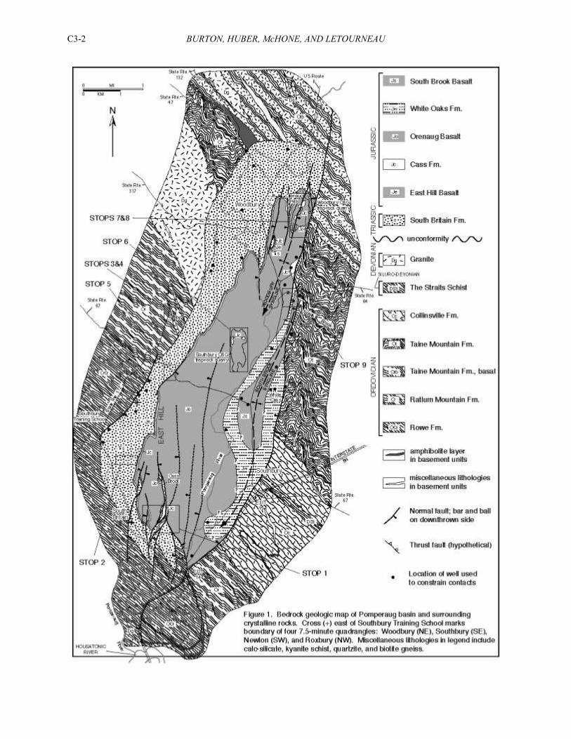
The new bedrock geologic map of the Pomperaug basin (Fig. 1) employs a topographic base digitally assembled
from portions of the four quadrangles, at a scale of 1:12,000. In addition to lithologic contacts the map contains data
on bedding, joints, and faults within the basin, and both ductile and brittle structural data from the surrounding
crystalline rocks out to a distance of 1 to 2 km from the basin margin. The mapping of the crystalline rocks was
done in an effort to better understand the crustal response to extension during rifting and formation of the basin.
History of previous geologic work in the basin
The first observations on the geology of the Pomperaug basin were made by Silliman (1820) and Hitchcock
(1828), both of whom noted the broad similarity of the succession of sedimentary and “trap” rocks with that of the
Hartford basin. In 1842, Percival portrayed a generalized distribution of rock units within the basin on the first
geologic map of Connecticut, and erected the first stratigraphic nomenclature for the Mesozoic rocks of Connecticut
(Percival, 1842), which persisted until Krynine (1950). Percival (1842) made a number of accurate observations of
the general geology of the basin, including the arrangement of traprock ridges and division of the main basalt into a
lower, massive member and an upper amygdaloidal member. He was followed in the 1880’s by William Morris
Davis
BURTON, HUBER, McHONE, AND LETOURNEAU C3-2
BURTON, HUBER, McHONE, AND LETOURNEAU C3-3
(1888), who concentrated on two areas of the Pomperaug basin near the south and north ends, respectively, of the
basin: the hill and river exposures in and east of the village of South Britain, and the Orenaug Hills in the town of
Woodbury. In South Britain, Davis mapped a relatively thick lower sandstone unit grading up to coarse arkose and
conglomerate, overlain by a thin amygdaloidal basalt, a thin shale interval, and a thick basalt. He was the first to
recognize that multiple traprock ridges in both the South Britain and Woodbury areas were the product of north-
trending, steeply-dipping normal faults repeating the section, and that the Pomperaug basin was an east-tilted half-
graben. Davis used his new block-faulting model in later studies of the Hartford and other early Mesozoic basins.
Around this time an oil exploration well was drilled in the eastern part of the basin, as reported in an article in
Scientific American by E.O. Hovey (1890). The well went through two trap sheets separated by shale, and the total
thickness of the Mesozoic section was determined to be 1,235 feet. In 1892, I. C. Russell included a generalized
map of both the Hartford and Pomperaug basins in his Correlations of the Newark System (Russell, 1892), along
with a synthesis of the “Broad Terrane” basin model. This concept envisioned all the various Newark Supergroup
basins as erosional remnants of an originally expansive depositional basin, extending from Nova Scotia to Alabama,
along the coast regions and as far inland as western Virginia.
William Herbert Hobbs, a geologist with the USGS, was the first to map the entire Pomperaug basin and study
its geology in detail, publishing his results in the 21st Annual Report of the United States Geological Survey (Hobbs,
1901). Following on the work of Davis (1888) and the oil well report of Hovey (1890), he recognized a lower, thin,
amygdaloidal “anterior basalt” and an upper, thicker “posterior basalt,” separated by a thin interval of “anterior
shale” that contained a limestone horizon. His report contains detailed descriptions of exposures and petrographic
descriptions of the lithologies. Along with his own observations he recorded information from others who had first-
hand knowledge of the geology of the area, including a local minister who had collected fish fossils from the shale,
farmers who had incorporated into their stone fences pieces of fossil wood from near the base of the lower
sandstone, and witnesses to the drilling of the oil exploration well—all information that would have been
unrecoverable later. Hobbs reported a “posterior shale” above the upper basalt, based on the existence of an outcrop
of black shale near the oil well, now gone, that was later represented by a bedding strike and dip symbol on the
Bedrock Geological Map of Connecticut (Rodgers, 1985).
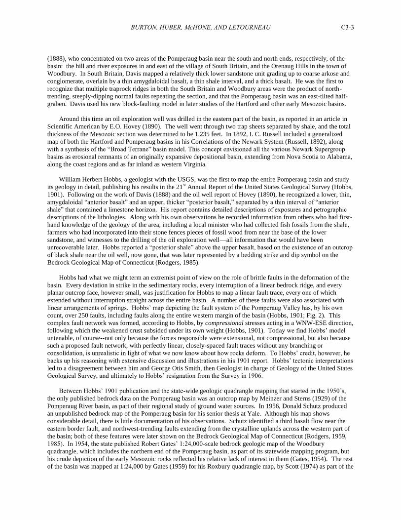
Hobbs had what we might term an extremist point of view on the role of brittle faults in the deformation of the
basin. Every deviation in strike in the sedimentary rocks, every interruption of a linear bedrock ridge, and every
planar outcrop face, however small, was justification for Hobbs to map a linear fault trace, every one of which
extended without interruption straight across the entire basin. A number of these faults were also associated with
linear arrangements of springs. Hobbs’ map depicting the fault system of the Pomperaug Valley has, by his own
count, over 250 faults, including faults along the entire western margin of the basin (Hobbs, 1901; Fig. 2). This
complex fault network was formed, according to Hobbs, by compressional stresses acting in a WNW-ESE direction,
following which the weakened crust subsided under its own weight (Hobbs, 1901). Today we find Hobbs’ model
untenable, of course--not only because the forces responsible were extensional, not compressional, but also because
such a proposed fault network, with perfectly linear, closely-spaced fault traces without any branching or
consolidation, is unrealistic in light of what we now know about how rocks deform. To Hobbs’ credit, however, he
backs up his reasoning with extensive discussion and illustrations in his 1901 report. Hobbs’ tectonic interpretations
led to a disagreement between him and George Otis Smith, then Geologist in charge of Geology of the United States
Geological Survey, and ultimately to Hobbs’ resignation from the Survey in 1906.
Between Hobbs’ 1901 publication and the state-wide geologic quadrangle mapping that started in the 1950’s,
the only published bedrock data on the Pomperaug basin was an outcrop map by Meinzer and Sterns (1929) of the
Pomperaug River basin, as part of their regional study of ground water sources. In 1956, Donald Schutz produced
an unpublished bedrock map of the Pomperaug basin for his senior thesis at Yale. Although his map shows
considerable detail, there is little documentation of his observations. Schutz identified a third basalt flow near the
eastern border fault, and northwest-trending faults extending from the crystalline uplands across the western part of
the basin; both of these features were later shown on the Bedrock Geological Map of Connecticut (Rodgers, 1959,
1985). In 1954, the state published Robert Gates’ 1:24,000-scale bedrock geologic map of the Woodbury
quadrangle, which includes the northern end of the Pomperaug basin, as part of its statewide mapping program, but
his crude depiction of the early Mesozoic rocks reflected his relative lack of interest in them (Gates, 1954). The rest
of the basin was mapped at 1:24,000 by Gates (1959) for his Roxbury quadrangle map, by Scott (1974) as part of the
BURTON, HUBER, McHONE, AND LETOURNEAU C3-4
Southbury quadrangle, and by Stanley and Caldwell (1976) for the Newtown quadrangle. Scott’s map of the
southeast portion of the basin is very detailed, showing three basalts within a stratigraphic section that is cut by
numerous northeast-trending faults, and truncated by an east-northeast-trending fault marking the southern end of
the basin. These map features were also incorporated into the newer Bedrock Geological Map of Connecticut
(Rodgers, 1985).
Figure 2. Hobbs' model of faulting in the Pomperaug basin, as published in the 21st Annual Report of the U.S.
Geological Survey (1901).
Hubert et al. (1978) and Weddle and Hubert (1983) were the first geologists to incorporate both petrologic data
and interpretations of sedimentary structures (grain lineation, cross bedding, facies analysis) into a depositional
model and paleogeographic reconstruction that portrayed Hartford and Pomperaug basin stratigraphic relationships.
These authors built upon an earlier modified “Broad Terrane model” advocated by Krynine (1950), who was the
BURTON, HUBER, McHONE, AND LETOURNEAU C3-5
first to engage in comparative petrology of the sedimentary rocks contained in both of the basins. These concepts
were reviewed and discussed further by Lorenz (1987). Cornet (1977) recovered palynomorphs and megafossil
plants from both basins, and McDonald (1982), Olsen et al. (1982) and Olsen (1984) collected fossil plants and
fishes and discussed aspects of Pomperaug basin stratigraphy and paleogeography. Tolley (1985) suggested a
stratigraphy that largely mirrored that of the Hartford basin, while Huber and McDonald (1992) provided a revised
stratigraphic framework and fossil distribution for the Pomperaug basin that closely resembled Hobbs’ (1901)
original interpretation. LeTourneau and Huber (1997, in review) described a basin-wide eolian sand sheet occurring
just below the main, ridge-forming basalt in the basin, and several papers on Hartford basin basalts (i.e. Hurtubise
and Puffer, 1983; Philpotts et al., 1996) also included geochemical analyses of this flow unit.
Constructing a new geologic map of the basin
New mapping of the Pomperaug basin was begun in October, 2003 and completed in April, 2005 (Fig. 1).
Following the advice of LeTourneau, Huber, and McHone, Burton first visited areas of good exposure such as the
Platt Farm Preserve, Cass Brook, and Red Spring, the east flank of East Hill, the O&G trap rock quarries in
Woodbury and Southbury, and South Brook. Along with the use of traditional mapping tools, station and outcrop
data were recorded on magnified raster images of the 1:24,000-scale topographic bases using a pocket PC with a
GPS running ArcPad, and structural data were recorded on a palmtop device using Pendragon Forms. This was
especially important for mapping areas such as Cass Brook (Stop 1), where closely-spaced faults juxtapose different
formations over distances of a few meters to tens of meters. Thanks to the lithostratigraphy previously established
by Huber and McDonald (1992) and LeTourneau and Huber (1997; in review), tracing faults and assigning senses of
offset was a relatively straightforward exercise in this area. Another critical area was the trap rock quarry in
Woodbury (Stop 7), which exposed a fault with a clearly demonstrable east-side-down and left-lateral sense of offset
that became a model for other, less well-exposed faults in the basin. Recovery of two of Hobbs’ (1901) arkose
outcrops in the Orenaug Hills, and a new exposure of a basalt/sedimentary rock contact in the Woodbury quarry
(Stop 8), helped outline a hanging-wall syncline near the north end of the basin. Careful examination of the
exposures in South Brook (Stop 9) led to the rediscovery of a conglomerate/basalt contact first noted by Schutz
(1956), and new geochemical analysis of the basalt supports the existence of a third basalt (Hampden equivalent), as
shown on the Bedrock Geological Map of Connecticut (Rodgers, 1985). Many of the basalt outcrops in the basin
were visited in order to obtain information on jointing. Domestic well records were compiled by Claudia Tamayo of
the USGS Water Science Center in East Hartford, and lithologic logs from these records were critical in helping to
constrain contacts in poorly-exposed areas of the basin.
In addition to the mapping of the basin, the metamorphic basement rocks surrounding the basin were mapped
out to a distance of 1-2 km. The primary reason for this was to gauge the response of these rocks to faulting and
crustal extension, to check the trace of the eastern border fault, and to help confirm or deny the existence of
northwest- and east-northeast-trending faults that are shown on the state geologic map (Rodgers, 1985). This
necessarily involved detailed lithologic mapping and an attempt to reconcile field descriptions of rock type with the
formations shown on the state map. The new crystalline-rock mapping helped disprove the existence of most of the
Mesozoic faults shown cutting the basement, retraced the eastern border fault along its southern extension, and
yielded a broader perspective on Mesozoic crustal extension in the area. In addition, study of the pre-Mesozoic
ductile structures in the crystalline rocks has spawned new ideas about the Paleozoic tectonic evolution of these
rocks.
LITHOSTRATIGRAPHIC FRAMEWORK OF THE POMPERAUG BASIN
Phillip Huber and Peter M. LeTourneau
Introduction
The Pomperaug basin preserves at least ~400 m of strata and intercalated basalts that, with one exception, have
been traditionally assigned the same unit names as the broadly coeval rocks of the Hartford Group that fill the
nearby Hartford basin. Regardless of the persistent controversy regarding the depositional relationship of these
rocks with those of the Hartford basin, Pomperaug basin strata and basalts are lithostratigraphically distinct from
their Hartford basin correlatives, and merit a nomenclature of their own. We recognize five formation-rank units in
the Pomperaug basin (Fig. 3) and note the possibility that the basin-fill sequence might preserve one or more
BURTON, HUBER, McHONE, AND LETOURNEAU C3-6
younger units whose outcrop areas, if the units exist, are obscured by thick glacial and colluvial cover and/or
complicated intrabasinal structure. These strata and basalts are referred by us to the Pomperaug Group. Note, for
reasons too numerous to mention here, the chronostratigraphic-based Group-rank scheme suggested by Weems and
Olsen (1997) for strata contained by the collective basins of the Newark Supergroup, is not used here. However, our
usage of new lithostratigraphic names should be considered informal until the criterion of publication in a widely
distributed, peer-reviewed format is achieved (LeTourneau and Huber, in review). The purpose of clarifying and
revising the stratigraphy of the Pomperaug basin is to establish the correct number, sequence, and map pattern of
rock units used for paleogeographic and paleoclimatic analysis. With the exception of Hobbs (1901), previous work
in the basin showed little agreement between the actual stratigraphy and the location of the sedimentary and volcanic
rocks that fill the basin (e. g. see maps by Scott, 1974; Rodgers, 1985).
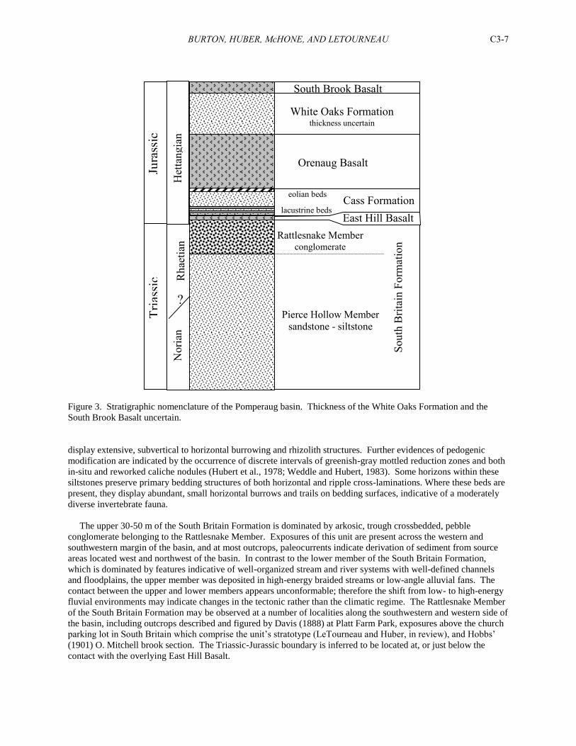
The Pomperaug Group consists of at least five formation-rank units which are, in ascending order: South Britain
Formation (~250 m) which consists of the lower, Pierce Hollow (~200 m) and upper, Rattlesnake Hill (~50 m)
Members; East Hill Basalt (7-10 m); Cass Formation (35 m); Orenaug Basalt (~80 m); and White Oaks Formation
(60m+?) (Fig. 3). Recent mapping and geochemical work supports the presence of a third basalt flow, herein
referred to as the South Brook Basalt. Details concerning the justification for new rock unit names, and the
designation and description of appropriate type and reference sections, will be published by LeTourneau and Huber
(in review).
South Britain Formation
The South Britain Formation is composed of siltstone and fine to coarse-grained arkosic sandstone and pebble
conglomerate that represent the oldest strata deposited in the Pomperaug basin (Upper Triassic, Norian-Rhaetian
age). These strata were originally named South Britain Conglomerate by Hobbs (1901), while Krynine (1950) and
subsequent workers assigned these rocks to the New Haven Arkose (e. g. Rodgers et al., 1959; Scott, 1974 (in part);
Hubert et al., 1978; Weddle and Hubert, 1983; Rodgers, 1985). The South Britain Formation is approximately 250
meters thick, and at least the uppermost ~170 m are well exposed in composite at several localities. Percival (1842)
discovered a locality near South Britain Village where he found “a mass of sandstone [reposed] on the primary
slate,” but neither we nor Hobbs (1901) could locate that outcrop. The basal ~80 m of the formation, including the
unconformable and/or fault contact with crystalline rocks have been penetrated by at least two wells (Hovey, 1890;
Janet Stone, pers. comm., 1996), and the contact of these strata with basement rocks at the western margin of the
basin can be located with reasonable accuracy based on outcrops, topography, and well data. The top of the
formation is defined by its contact with the overlying East Hill Basalt. The lower ~200 m of these strata are
assigned to the Pierce Hollow Member, while the upper ~30-50 m are called the Rattlesnake Member (Fig. 3).
The lower ~80 m of the Pierce Hollow Member are not exposed. However, Hobbs (1901) excavated small areas
immediately south of the preserved basin margin, along the eastern slope of what was then called Horse Hill (there
are two hills near South Britain called Horse Hill, though only one of these is named on recent editions of the
Southbury 7.5’ quadrangle. The named feature is not the location of Hobbs’ observations nor the location of his
petrified wood locality). He found small pockets of sediment preserved within small depressions of crystalline
basement, and the topographic surface represents the exhumed basin floor. This is significant as it indicates strata
extended over a small area south and beyond the basin’s present limits, and beyond the inferred northeast-trending
“Pomperaug fault” of Scott (1974). Strata comprising the next ~50 m of the Pierce Hollow Member are well
exposed at several localities. These beds consist of 1-5 m thick sequences of red-brown channel sandstones and
overbank siltstones. The channels are broadly lenticular, ripple-laminated, trough crossbedded or massive sandstone
bodies that usually have a thin, extrabasinal pebble or intraclast zone at their base. The immature sandstones plot
well within the compositional field for arkose (Weddle and Hubert, 1983). Floodplain deposits are represented by
relatively thin (1 m or less), structureless to disrupted bedded/pedoturbated siltstone. Excellent exposures of the
Pierce Hollow Member are found along the Pomperaug River in South Britain; these outcrops were described by
Schutz (1956), Hubert and others (1978), Weddle and Hubert (1983), and Lorenz (1987).
The next ~75 m of strata display features illustrative of classic, fining upward point bar sequences, and consist of
thin pebble conglomerates (~1 m or less thick) overlain by as much as 18 m of massive, ripple cross-laminated
and/or bedding disrupted siltstone. The basal conglomeritic units are noteworthy for containing abundant carbonate
pebbles, some of which we believe were derived from the Stockbridge Marble, a unit that is restricted in outcrop to
areas located some 12 km or more to the west and northwest. Most of the siltstone beds have disrupted bedding and
BURTON, HUBER, McHONE, AND LETOURNEAU C3-7
Figure 3. Stratigraphic nomenclature of the Pomperaug basin. Thickness of the White Oaks Formation and the
South Brook Basalt uncertain.
display extensive, subvertical to horizontal burrowing and rhizolith structures. Further evidences of pedogenic
modification are indicated by the occurrence of discrete intervals of greenish-gray mottled reduction zones and both
in-situ and reworked caliche nodules (Hubert et al., 1978; Weddle and Hubert, 1983). Some horizons within these
siltstones preserve primary bedding structures of both horizontal and ripple cross-laminations. Where these beds are
present, they display abundant, small horizontal burrows and trails on bedding surfaces, indicative of a moderately
diverse invertebrate fauna.
The upper 30-50 m of the South Britain Formation is dominated by arkosic, trough crossbedded, pebble
conglomerate belonging to the Rattlesnake Member. Exposures of this unit are present across the western and
southwestern margin of the basin, and at most outcrops, paleocurrents indicate derivation of sediment from source
areas located west and northwest of the basin. In contrast to the lower member of the South Britain Formation,
which is dominated by features indicative of well-organized stream and river systems with well-defined channels
and floodplains, the upper member was deposited in high-energy braided streams or low-angle alluvial fans. The
contact between the upper and lower members appears unconformable; therefore the shift from low- to high-energy
fluvial environments may indicate changes in the tectonic rather than the climatic regime. The Rattlesnake Member
of the South Britain Formation may be observed at a number of localities along the southwestern and western side of
the basin, including outcrops described and figured by Davis (1888) at Platt Farm Park, exposures above the church
parking lot in South Britain which comprise the unit’s stratotype (LeTourneau and Huber, in review), and Hobbs’
(1901) O. Mitchell brook section. The Triassic-Jurassic boundary is inferred to be located at, or just below the
contact with the overlying East Hill Basalt.
Jura
ssic
T
rias
sic
Nori
an
Rhae
tian
H
etta
ngia
n
?
Cass Formation
South
Bri
tain
Form
atio
n
Pierce Hollow Member
sandstone - siltstone
Rattlesnake Member conglomerate
eolian beds
lacustrine beds
Orenaug Basalt
East Hill Basalt
White Oaks Formation thickness uncertain
South Brook Basalt
BURTON, HUBER, McHONE, AND LETOURNEAU C3-8
East Hill Basalt
The East Hill Basalt is the stratigraphically-lowest extrusive unit in the Pomperaug basin, and is named for
exposures that occur near the eastern base of East Hill, just northwest of Hobbs’ (1901) Red Spring locality (for
details, see LeTourneau and Huber, in review). Previous names for this unit include “Anterior Basalt” (Percival,
1842; Davis, 1888; Hobbs, 1901; Krynine, 1950; Rodgers and others, 1959), “Talcott Basalt” (Hubert and others,
1978; Weddle and Hubert, 1983; Rodgers, 1985; Tolly, 1985), and “Talcott Formation” (Scott, 1974). Hobbs
(1901) accurately mapped the distribution of most known outcrops of the East Hill Basalt, while Rodgers missed
several critical outcrop areas on the Bedrock Geological Map of Connecticut (Rodgers, 1985). Scott (1974) mapped
the entire outcrop area (Red Spring locality) that includes the 10 m-thick East Hill Basalt stratotype as “New Haven
Arkose,” though only 1 m or less of South Britain Formation actually crops out in the area, and no indication of this
basalt unit (or the overlying Cass Formation) was included on his map.
At its type section, the East Hill Basalt consists of a 10 m-thick vesicular basalt that directly overlies the
Rattlesnake Member of the South Britain Formation and is capped by basal siltstones of the overlying Cass
Formation. The East Hill Basalt is a high-TiO2 quartz tholeiite that is correlated with the Talcott Basalt of the
Hartford basin, Orange Mountain Basalt of the Newark Basin and North Mountain Basalt of the Fundy basin on the
basis of both stratigraphic position and geochemistry (McHone, 2003c). Three other complete sections of the East
Hill Basalt are known in the South Britain area: (1) along Cass Brook in Platt Farm Park, just below the type section
of the Cass Formation (discussed below); (2) at the southwestern margin of Platt Farm Park (Spring House locality
of Hobbs (1901); and at O. Mitchell Brook, in contact with, and above, the section designated by LeTourneau and
Huber (in review) as the lectostratotype of the South Britain Formation. Other scattered outcrops are common in the
southwest area of the basin, and include those on Pine Hill originally mapped by Davis (1888), at Red Spring, and
the east side of Rattlesnake Hill (Hobbs, 1901). A discussion of this basalt’s correlation with other basin basalts
follows below.
Cass Formation
The Cass Formation overlies the East Hill Basalt, and is named for outcrops along lower Cass Brook at Platt
Farm Park, Southbury, Connecticut. The Cass Formation is 35-40 m thick and composed of: 1) black and buff,
laminated to massive micrite, and black and gray, laminated to microlaminated calcareous shale; 2) gray and red,
laminated, ripple cross-laminated and massive to nodular siltstone; and 3) red-brown and buff, fine- to coarse-
grained, moderately to poorly sorted, arkosic, litharenitic and quartzose sandstone and pebble-cobble conglomerate.
Previous names used to describe Cass Formation strata include “Anterior Shale (Percival, 1842; Davis, 1888;
Hobbs, 1901; Longwell, 1933; Krynine, 1950); Shuttle Meadow Formation (Rodgers et al., 1959; Hubert et al.,
1978; Weddle and Hubert, 1983; Tolley, 1985; Rodgers, 1985), and Talcott Formation (Scott, 1974). The Cass
Formation is basal Jurassic (lowermost Hettangian) in age and, based on the composition of its palynofloral and
fossil fish assemblages, belongs to the Wassonian Land Vertebrate Faunachron of Lucas and Huber (2003). The
Cass Formation thus correlates with the Shuttle Meadow Formation of the Hartford basin, the Feltville Formation of
the Newark Basin, the Midland Formation of the Culpeper Basin, and the Scotts Bay and McCoy Brook Formations
of the Fundy basin.
The Cass Formation stratotype comprises two outcrops that, combined, represent the lower 14 m of the
formation. The base of Section “A” is located along the small, easterly bend of Cass Brook just below the
footbridge, 150 m north of the Platt farmhouse (see trip log of Stop 1 for location). Section A consists of 4.8 m of
strata that begin with 2 m of red, ripple cross-laminated and evenly laminated siltstone directly overlying East Hill
Basalt. These beds are gradational with 2.8 m of overlying gray, laminated siltstone that passes upward into dark
gray to black, finely laminated shale and laminated limestone. Immediately overlying beds are covered, but low,
poorly exposed outcrops of gray siltstone occur in the bed of the stream several meters east, where Cass Brook
bends to flow south. Cornet (1977) recovered a moderately diverse, Corollina-dominated palynoflora from the dark
shales and siltstones, and these strata also contain a low diversity megaflora of Brachyphyllum conifer foliage and
less common cycad (cf. Otozamites sp.) and equisetalian fragments. The black shale and limestone unit contains
moderately abundant fossil fish that occur as isolated scale and dermal elements to fully-articulated specimens of
Redfieldius gracilis and Semiontous sp. The limestone unit is notable for its bitumen-coated fractures (Fig. 4), and
will literally bleed bitumen within several minutes upon a fresh break with a hammer. The unit certainly is a mature
source rock, and perhaps provided the impetus for the failed oil well venture reported by Hovey (1890).
BURTON, HUBER, McHONE, AND LETOURNEAU C3-9
Section B of the Cass Formation stratotype is located ~300 m upstream from section “A” and begins with gray
siltstone of the same lacustrine beds exposed at Section A that are here faulted against the Orenaug Basalt. The beds
are tilted vertical at the fault contact, but rapidly splay toward horizontal within several meters laterally, where they
assume strike and dip values within the regional average (strike: N25E, dip 25SE). The gray siltstone is gradational
with overlying red, ripple cross laminated siltstone that is largely structureless for the next 7 m of exposure along the
stream bed. The upper part of Section B is a small stream bank outcrop of red siltstone comprising a 2 m-high
vertical face. Near the top of this outcrop are gray limestone nodules within a reddish-purple siltstone that occur 14
m above the base of the East Hill Basalt. Scattered float blocks suggest the presence of a bedded to massive
limestone higher in the stream bank. If present, this bed would correlate with the Red Spring Limestone bed
discussed below.
The Red Spring locality of Hobbs (1901) shows sparse outcrops that represent the lower 3 m of the formation,
and an additional 1 m-thick interval located 15 m above the East Hill Basalt adjacent to its type section. Abundant
float blocks of the laminated micrite unit are scattered throughout the area, and are likely evidence of the trenching
efforts described by Hobbs (1901) in his report. At 15 m above the East Hill Basalt, a 0.5 m-thick, massive, white to
buff-colored limestone is poorly exposed, and bracketed by gray and red shale. This is the limestone mentioned by
Hitchcock (1828) and Hobbs (1901) that was quarried for water lime early in the 19th
century. Hobbs (1901) noted
the presence of fossil fishes from this limestone, and more recent collecting efforts indicate isolated squamation and
dermal elements to articulated specimens of Redfieldius sp. and Semionotus sp. are moderately abundant. When
dissolved in 5% acetic acid for a two week period, the limestone readily dissolves. A 2 kg sample was processed
and picked for fossils which revealed abundant piscine elements as well as small, ovoid scales that might represent
lacertalian reptiles (N. Fraser, pers. comm. 1997). The Red Spring section is important for its paleontological
potential, and also because the entire thickness of the Cass Formation can be measured in one location with
reasonable accuracy. The contact with the overlying Orenaug Basalt is concealed, but is estimated to occur 35 m
above the East Hill Basalt-Cass Formation contact.
Outcrops of the middle Cass Formation are sparse and consist of small, isolated exposures in Platt Farm Park and
a more lengthy, albeit overgrown, cut along a gravel fire road that lies south of and parallel to the O. Mitchell Brook
section of Hobbs (1901). This location exposes 10 m of section that include a 1 m-thick gray lacustrine siltstone and
shale interval that occurs some 20 m above the base of the formation. The top of the section is defined by a poorly
exposed, arkosic sandstone, above which is apparently a trough crossbedded quartzose sandstone, based on loose
blocks that have weathered loose from the highly vegetated slope.
The upper Cass Formation was formerly well exposed at both the Southbury and Woodbury O & G Industries
quarries, and the former location displayed an 11 m-thick section dominated by diverse coarse clastics that included
mid- and distal alluvial fan facies containing abundant, natural sandstone molds and casts of dinosaur and other
tetrapod bones, a well-defined paleosol horizon, a pebble conglomerate that includes abundant extrabasinal clasts
derived from the Stockbridge Marble, a dinosaur track-bearing horizon, and a 2.5 m-thick eolian sandsheet. A
synthesis and discussion of these outcrops is included with the trip description for Stop 6).
Orenaug Basalt
The Orenaug Basalt is herein named for the 80+ m thick basalt that is the main ridge-forming unit in the basin.
The stratotype of the Orenaug Basalt is located just southeast of Woodbury Village in a town-maintained park, and
consists of 10 m of cliff exposures that overlook a small pond (see LeTourneau and Huber, in review). The Orenaug
basalt is a quartz tholeiite, and it has been attributed several names in the older literature including Davis (1888),
Hobbs (1901), Rodgers et al. (1959), “Holyoke Basalt” (Scott, 1974; Rodgers, 1985) and “Main Basalt” (Huber and
McDonald, 1992).
According to the Southbury quarry exposure, Orenaug Basalt contains at least two, and possibly three flow units,
but attempts to map these individual units in the rest of the Pomperaug basin have been unsuccessful. The top of
one flow is well defined by a vesicular texture and weathered horizon, and the undulating base of the succeeding
flow displays pipe vesicles and at least 2 m of relief. This horizon occurs in the Southbury quarry at approximately
40 m above the Cass Formation-Orenaug Basalt contact. A possible, stratigraphically-lower flow contact occurs
about 20 m above the Cass-Orenaug contact where a laterally-continuous, 0.1 m-thick zone of highly fractured
BURTON, HUBER, McHONE, AND LETOURNEAU C3-10
basalt and clayey mush delimits a change in lithology from black massive, highly compacted basalt with abundant
silica minerals (clear quartz, amethyst, banded agate) to a dark gray, columnar basalt that contains abundant cavities
filled with zeolite minerals. However, there is much less of a textural contrast at this boundary than at the overlying
flow boundary. (See also discussion in section below on internal basalt stratigraphy).
White Oaks Formation
The name White Oaks Formation is given for the sequence of largely covered strata that occurs above the
Orenaug Basalt and below the possible third basalt unit in the Pomperaug basin, the South Brook Basalt (see below).
The only currently known exposures are small ledges of conglomerate and pebbly arkose in South Brook (Stop 9),
which comprise the north end of the inferred belt of White Oaks Formation (Fig. 1). The rest of the inferred belt is
almost entirely covered by glacial debris, natural vegetation, and artifacts of human development such as golf
courses and strip malls, and is based largely on structural considerations and interpretation of well logs (Fig. 1).
Hobbs (1901) confirmed the existence of at least one lacustrine black shale bed that was located near the failed oil
well venture (see well location near Pomperaug River east of East Hill in Figure 1), and Hovey (1890) documented
that this drilling enterprise encountered an unknown thickness of strata before penetrating the upper of two basalt
units. The White Oaks Formation is correlative with the East Berlin Formation of the Hartford basin, Turners Falls
Formation of the Deerfield basin, and Towaco Formation of the Newark basin, based on its stratigraphic position
between the “second” and “third” basalt flows.
We have collected large (0.5 m-thick) float blocks of organic- and carbonate-rich laminated black shale from a
gravel pit located along Main Street South in Southbury that do not resemble any of the three lacustrine black shales
of the Cass Formation, and therefore, are attributed to the White Oaks Formation. Blocks of a similar shale were
also collected by Paul Olsen (pers. comm., 1992) in the 1970s during the construction of the Southbury Plaza
shopping center. The thickness and lithologies contained by the White Oaks Formation are otherwise unknown, but
a conservative minimal estimate of 50 m thick seems reasonable, based on the distribution of stratigraphically-
adjacent basalts in combination with topography.
South Brook Basalt
Immediately above and in contact with the arkose and conglomerate in South Brook is a highly altered,
vesicular basalt that superficially resembles the East Hill Basalt (Stop 9). The basalt occupies the core of a hanging-
wall syncline next to the eastern border fault (Fig. 1, Stop 9), and its exposed thickness, about 10 meters or so, is
permissible for the East Hill Basalt. However, the two samples that have been analyzed from this site have a
chemistry that, despite alteration of the samples, is distinct from the East Hill and Orenaug Basalts and their
Hartford and Newark basin equivalents, as discussed below. We therefore infer the existence of a third basalt,
possibly equivalent to the Hampden (Hartford basin) and Hook Mountain (Newark basin) Basalts, on the basis of
both the chemistry and the position of this basalt at the east margin of an east-tilted half-graben, where a
stratigraphically higher flow would be expected. The area underlain by this basalt is inferred to extend southward
on the basis of well records and the fact that the underlying White Oaks Formation likely also extends a considerable
distance southward, as discussed above (Fig. 1).
POMPERAUG BASIN BASALTS
J. Gregory McHone
A major lithostratigraphic aspect of the Early Mesozoic basins of northeastern North America is the presence,
age, and position of basaltic lava flows. After many years of uncertainty and confusion, the absolute ages of basalts,
sills, and dikes within and surrounding the basins are now reasonably well established to be between 200 and 201
Ma, and they formed during three major volcanic events spanning about 600,000 years (Olsen and others, 1996;
McHone, 1996; Olsen et al., 1996; West and McHone, 1997). In addition, basalts within the larger basins are
closely correlated by chemistry, paleomagnetics, and stratigraphy, and in essence must be co-magmatic flows
(Puffer et al., 1981; Hozik, 1992; Puffer, 1992). As shown in Figure 4, there are three separate basalts (some
containing several flow units) within the adjacent Newark (New Jersey) and Hartford (Connecticut) basins, and
other basalts in the Culpeper (Virginia) and Fundy (Nova Scotia and New Brunswick) basins are also correlated
(Olsen, 1997). Two similar basalts exist in Morocco, which prior to rifting was adjacent to eastern Canada. The
BURTON, HUBER, McHONE, AND LETOURNEAU C3-11
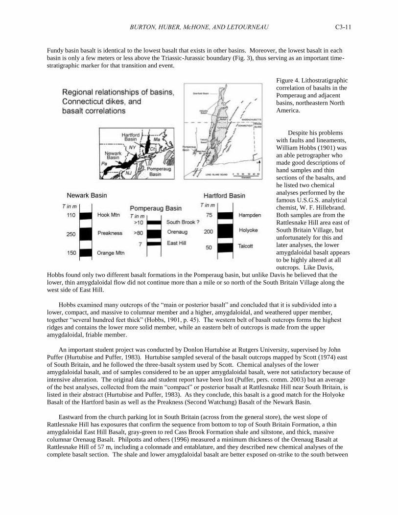
Fundy basin basalt is identical to the lowest basalt that exists in other basins. Moreover, the lowest basalt in each
basin is only a few meters or less above the Triassic-Jurassic boundary (Fig. 3), thus serving as an important time-
stratigraphic marker for that transition and event.
Figure 4. Lithostratigraphic
correlation of basalts in the
Pomperaug and adjacent
basins, northeastern North
America.
Despite his problems
with faults and lineaments,
William Hobbs (1901) was
an able petrographer who
made good descriptions of
hand samples and thin
sections of the basalts, and
he listed two chemical
analyses performed by the
famous U.S.G.S. analytical
chemist, W. F. Hillebrand.
Both samples are from the
Rattlesnake Hill area east of
South Britain Village, but
unfortunately for this and
later analyses, the lower
amygdaloidal basalt appears
to be highly altered at all
outcrops. Like Davis,
Hobbs found only two different basalt formations in the Pomperaug basin, but unlike Davis he believed that the
lower, thin amygdaloidal flow did not continue more than a mile or so north of the South Britain Village along the
west side of East Hill.
Hobbs examined many outcrops of the “main or posterior basalt” and concluded that it is subdivided into a
lower, compact, and massive to columnar member and a higher, amygdaloidal, and weathered upper member,
together “several hundred feet thick” (Hobbs, 1901, p. 45). The western belt of basalt outcrops forms the highest
ridges and contains the lower more solid member, while an eastern belt of outcrops is made from the upper
amygdaloidal, friable member.
An important student project was conducted by Donlon Hurtubise at Rutgers University, supervised by John
Puffer (Hurtubise and Puffer, 1983). Hurtubise sampled several of the basalt outcrops mapped by Scott (1974) east
of South Britain, and he followed the three-basalt system used by Scott. Chemical analyses of the lower
amygdaloidal basalt, and of samples considered to be an upper amygdaloidal basalt, were not satisfactory because of
intensive alteration. The original data and student report have been lost (Puffer, pers. comm. 2003) but an average
of the best analyses, collected from the main “compact” or posterior basalt at Rattlesnake Hill near South Britain, is
listed in their abstract (Hurtubise and Puffer, 1983). As they conclude, this basalt is a good match for the Holyoke
Basalt of the Hartford basin as well as the Preakness (Second Watchung) Basalt of the Newark Basin.
Eastward from the church parking lot in South Britain (across from the general store), the west slope of
Rattlesnake Hill has exposures that confirm the sequence from bottom to top of South Britain Formation, a thin
amygdaloidal East Hill Basalt, gray-green to red Cass Brook Formation shale and siltstone, and thick, massive
columnar Orenaug Basalt. Philpotts and others (1996) measured a minimum thickness of the Orenaug Basalt at
Rattlesnake Hill of 57 m, including a colonnade and entablature, and they described new chemical analyses of the
complete basalt section. The shale and lower amygdaloidal basalt are better exposed on-strike to the south between
BURTON, HUBER, McHONE, AND LETOURNEAU C3-12
Rattlesnake Hill and Sherman Hill, and especially along Cass Brook, and the same sequence occurs along the
western slope of Pine Hill as well (Davis, 1888; Fig. 1).
Hobbs (1901) believed that the uppermost portion of the South Britain Formation is indurated, or hardened by
mineralization related to heating from the overlying basalts, which may partially explain the resistant ridge of
conglomeratic arkose exposed high up on the slope of Rattlesnake Hill. Outcrops in this area show northerly strikes
and steep dips of 20º to 30º eastward. However, there are abrupt changes in the attitudes of basalts and sedimentary
strata around Cass Brook, as described by Hobbs (1901) and Scott (1974). These are related to high angle faults
with north-south to northeast-southwest trends and generally west-sides down (Fig. 1). In addition, strata dips
become less steep (10º to 20º) toward the east to southeast. Several faults are exposed along Cass Brook, some
associated with “reibungsbreccia,” which as described by Hobbs (1901) as an unusual tectonic breccia formed by
fault activity between solid basalt and unlithified shale and siltstone.
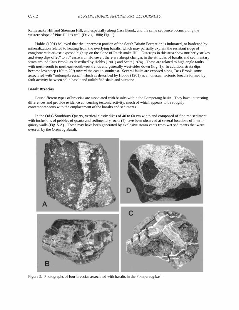
Basalt Breccias
Four different types of breccias are associated with basalts within the Pomperaug basin. They have interesting
differences and provide evidence concerning tectonic activity, much of which appears to be roughly
contemporaneous with the emplacement of the basalts and sediments.
In the O&G Southbury Quarry, vertical clastic dikes of 40 to 60 cm width and composed of fine red sediment
with inclusions of pebbles of quartz and sedimentary rocks (?) have been observed at several locations of interior
quarry walls (Fig. 5 A). These may have been generated by explosive steam vents from wet sediments that were
overrun by the Orenaug Basalt.
Figure 5. Photographs of four breccias associated with basalts in the Pomperaug basin.
BURTON, HUBER, McHONE, AND LETOURNEAU C3-13
In the O&G Park Road (Woodbury) Quarry, a vertical dike about 1 m wide of fine-grained light-gray “micritic”
calcium carbonate with inclusions of basalt was observed in an E-W interior quarry wall (Fig. 5 B). The carbonate
merges into calcite-lined vugs of several cm lengths adjacent to some of the angular basalt clasts.
“Reibungsbreccia” was considered by Hobbs (1901) to represent solid basalt faulted against unlithified
mudstone (see also discussion at Stop 1). As can be seen in Figure 5 C, pink to gray sediment has intruded highly-
weathered basalt in two or more generations of thin (1-2 cm) dikes. In all cases a thin border or rind of calcite has
precipitated against the basalt. Although this is best observed at Cass Brook in the Platt Farm Preserve (Stop 1),
similar breccias have been described from other localities within the basin.
Crystalline calcite surrounds basalt breccia in sub-vertical “veins” of 10 to 30 cm wide at the Southbury Quarry
(Fig. 5 D). A few small pieces of dark red sedimentary (?) clasts also occur within the calcite matrix, implying a
steam-driven origin like the red clastic dikes.
Internal Basalt Stratigraphy
As expected in thick lava flows, the Orenaug Basalt has developed internal divisions or members with visibly
distinct textures and colors. The most famous of these is the highly-altered prehnite-bearing member that has been a
target for mineral collectors for more than a century, especially at the O&G Southbury Quarry (formerly known as
the Silliman Quarry). The Southbury Quarry provides a continuous section through about 70 m of the lower part of
the Orenaug Basalt. The basalts and sedimentary strata are tilted eastward about 15º. As can be seen in the images
below (Fig. 6), its south-facing cuts expose boundaries that clearly define lower, middle, and upper members or flow
units. The lower member is about 18 m thick and is relatively massive to columnar, except near major fractures and
the basal contact zone. The middle member, about 25 m thick, is highly altered to a gray-green color and contains
abundant amygdales filled by calcite, quartz, prehnite, pumpellyite, apophyllite, and other minerals described by
Garabedian and others (1996). There are several lens-shaped sections in this member that might represent separate
lobes or lava tongues. The upper basalt member contains finger-sized basal tube vesicles directly over the brown
weathered upper surface of the middle member. This upper member is hard, dark gray, non-vesicular and massive
to columnar, although it displays pyrite roses on fracture surfaces.
The base of the upper (third) member displays proof in the form of pipe vesicles that it was a separate or second
Orenaug lava flow. The other boundary, between the lower and middle members, is relatively planar, although it
dips with the strata to the east, and is brown-stained (Fig. 6). A possible interpretation is that this represents the
boundary between a lower colonnade and entablature. It is not clear if another entablature exists over the third
member as well, as the top of the Orenaug Basalt is not clearly exposed.
These Southbury Quarry observations essentially confirm the previous descriptions by Percival, Davis, and
Hobbs concerning several petrographic units of the “Posterior” or Orenaug Basalt, in particular an amygdaloidal
prehnite-bearing member above a massive columnar lower member. The relatively massive lower and upper
members apparently form most of the ridges through the central sections of the Pomperaug basin, including the
Orenaug Hills, while the lower massive member must thicken to the south, where it forms the main ridges of East
Hill and Bear Hill in the western basin. The highly-altered and relatively soft middle member (containing most of
the prehnite and other late minerals) might exist under several of the strike valleys eroded between basalt ridges.
Because of its low durability, it has been eroded between the lower and upper basalt members, and so is an
important control on the topography.
The Woodbury traprock quarry is also operated by the O&G Corporation. It cuts out part of the “eastern twin”
of the Orenaug Hills in the northeastern section of the basin. The quarry operations have exposed large pavements
of white sandstone beneath the basalt, while the basalt itself is highly fractured and generally weathered. Although
there may be a boundary exposed between the lower and middle members, in general the flow relationships are hard
to define. The upper flow (third member) that is evident in the Southbury Quarry is either not present or not
exposed in the Woodbury Quarry. There are large piles of till that was bulldozed from the areas of quarry
expansion, which contain abundant red siltstone cobbles and boulders. It is likely that these represent South Britain
and/or Cass Brook sedimentary rocks from the northern end of the basin, which were carried into and over the
quarry area by glacial actions.
BURTON, HUBER, McHONE, AND LETOURNEAU C3-14
Figure 6. Images of the O&G Southbury Quarry. Upper left: prehnite “hearts” in a gas vesicle within the
middle basalt member. Upper right: red siltstone and sandstone breccia dike in a fracture within the lower basalt
member, possibly caused by explosive steam discharges from wet sediment beneath the basalt. Lower left: view to
the north showing boundaries that define the middle member. Note the lighter tone of the middle member. Lower
right: red siltstone (Cass Brook Fm.) and buff sandstone beneath the lower basalt member.
Basalt Petrography
Petrographic thin sections were prepared for samples from basalt outcrops in the South Britain area, the
traprock quarries, South Brook in Woodbury, and the Orenaug Hills. In general, hand samples of the East Hill
Basalt show the highly-weathered state of this formation. All samples show abundant small (BB-sized) vesicles and
amygdales filled with calcite or bluish-colored chalcedony. The basalt is generally soft and it crumbles when
hammered, except for a few places not close to fractures. In some places the rock has disintegrated into “fish
scales” that may be related to the shapes of gas bubbles. The basalt is very fine grained and may originally have
been glassy, and only a few minerals other than amygdales are recognized. In thin section, small laths of plagioclase
are abundant and well preserved, and clinopyroxene crystals can be recognized by their crystal forms (Fig. 7). No
phenocrysts of orthopyroxene, such as can be found in unaltered Talcott Basalt, were recognized, although they may
be present in altered forms.
In contrast to the East Hill Basalt, the upper and lower members of the Orenaug Basalt are typically massive,
medium grained, and relatively unaltered. Hand samples are hard, and fresh surfaces are dark gray with small
feldspar crystals visible. In thin section, the basalt is subophitic, with fresh clinopyroxenes and abundant
plagioclase, and scattered phenocrysts that might be relict olivines (Fig. 8). The middle prehnite-bearing member is
more altered, as expected.
BURTON, HUBER, McHONE, AND LETOURNEAU C3-15
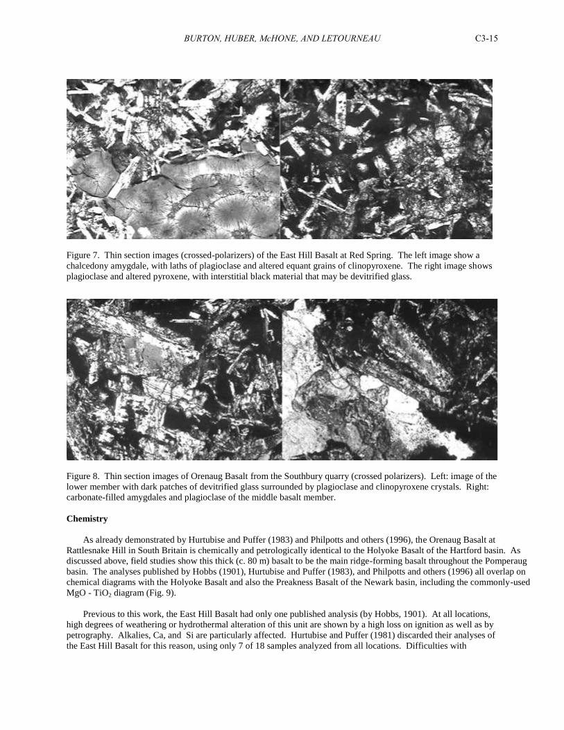
Figure 7. Thin section images (crossed-polarizers) of the East Hill Basalt at Red Spring. The left image show a
chalcedony amygdale, with laths of plagioclase and altered equant grains of clinopyroxene. The right image shows
plagioclase and altered pyroxene, with interstitial black material that may be devitrified glass.
Figure 8. Thin section images of Orenaug Basalt from the Southbury quarry (crossed polarizers). Left: image of the
lower member with dark patches of devitrified glass surrounded by plagioclase and clinopyroxene crystals. Right:
carbonate-filled amygdales and plagioclase of the middle basalt member.
Chemistry
As already demonstrated by Hurtubise and Puffer (1983) and Philpotts and others (1996), the Orenaug Basalt at
Rattlesnake Hill in South Britain is chemically and petrologically identical to the Holyoke Basalt of the Hartford basin. As
discussed above, field studies show this thick (c. 80 m) basalt to be the main ridge-forming basalt throughout the Pomperaug
basin. The analyses published by Hobbs (1901), Hurtubise and Puffer (1983), and Philpotts and others (1996) all overlap on
chemical diagrams with the Holyoke Basalt and also the Preakness Basalt of the Newark basin, including the commonly-used
MgO - TiO2 diagram (Fig. 9).
Previous to this work, the East Hill Basalt had only one published analysis (by Hobbs, 1901). At all locations,
high degrees of weathering or hydrothermal alteration of this unit are shown by a high loss on ignition as well as by
petrography. Alkalies, Ca, and Si are particularly affected. Hurtubise and Puffer (1981) discarded their analyses of
the East Hill Basalt for this reason, using only 7 of 18 samples analyzed from all locations. Difficulties with
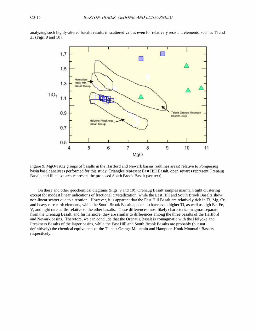
BURTON, HUBER, McHONE, AND LETOURNEAU C3-16
analyzing such highly-altered basalts results in scattered values even for relatively resistant elements, such as Ti and
Zr (Figs. 9 and 10).
Figure 9. MgO-TiO2 groups of basalts in the Hartford and Newark basins (outlines areas) relative to Pomperaug
basin basalt analyses performed for this study. Triangles represent East Hill Basalt, open squares represent Orenaug
Basalt, and filled squares represent the proposed South Brook Basalt (see text).
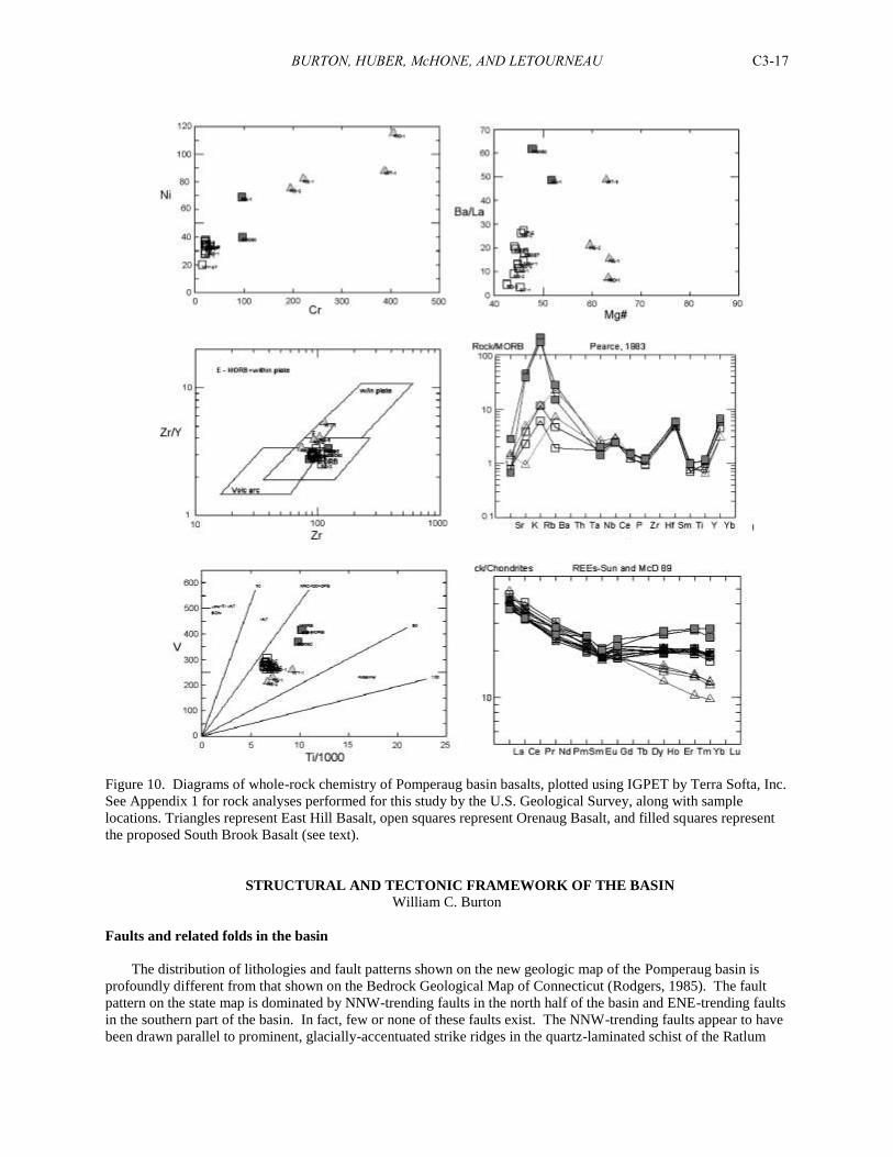
On these and other geochemical diagrams (Figs. 9 and 10), Orenaug Basalt samples maintain tight clustering
except for modest linear indications of fractional crystallization, while the East Hill and South Brook Basalts show
non-linear scatter due to alteration. However, it is apparent that the East Hill Basalt are relatively rich in Ti, Mg, Cr,
and heavy rare earth elements, while the South Brook Basalt appears to have even higher Ti, as well as high Ba, Fe,
V, and light rare earths relative to the other basalts. These differences most likely characterize magmas separate
from the Orenaug Basalt, and furthermore, they are similar to differences among the three basalts of the Hartford
and Newark basins. Therefore, we can conclude that the Orenaug Basalt is comagmatic with the Holyoke and
Preakness Basalts of the larger basins, while the East Hill and South Brook Basalts are probably (but not
definitively) the chemical equivalents of the Talcott-Orange Mountain and Hampden-Hook Mountain Basalts,
respectively.
BURTON, HUBER, McHONE, AND LETOURNEAU C3-17
Figure 10. Diagrams of whole-rock chemistry of Pomperaug basin basalts, plotted using IGPET by Terra Softa, Inc.
See Appendix 1 for rock analyses performed for this study by the U.S. Geological Survey, along with sample
locations. Triangles represent East Hill Basalt, open squares represent Orenaug Basalt, and filled squares represent
the proposed South Brook Basalt (see text).
STRUCTURAL AND TECTONIC FRAMEWORK OF THE BASIN
William C. Burton
Faults and related folds in the basin
The distribution of lithologies and fault patterns shown on the new geologic map of the Pomperaug basin is
profoundly different from that shown on the Bedrock Geological Map of Connecticut (Rodgers, 1985). The fault
pattern on the state map is dominated by NNW-trending faults in the north half of the basin and ENE-trending faults
in the southern part of the basin. In fact, few or none of these faults exist. The NNW-trending faults appear to have
been drawn parallel to prominent, glacially-accentuated strike ridges in the quartz-laminated schist of the Ratlum
BURTON, HUBER, McHONE, AND LETOURNEAU C3-18
Mountain Formation, northwest of the basin. The ENE-trending faults shown in the southern basin parallel those
originally drawn by Davis (1888) and later by Scott (1974) along notches in a ridge of South Britain Formation
arkose that lies just east of the Platt farm buildings. While Davis’ faults cannot be ruled out, their offsets, if they do
indeed exist, are small (~20 m or less), and therefore are not shown on the new map. The fault drawn by Scott that
truncates the south end of the basin is not compatible with Hobbs’ (1901) description of trenches that expose
redbeds which unconformably overlie schist on Horse Hill, south of the Pomperaug River and Scott’s mapped fault.
Eastern border fault. The eastern border fault of the Pomperaug basin is most tightly constrained near the
north end of the basin and particularly in South Brook, where a north-flowing segment of the brook follows the
border fault. Here Mesozoic sedimentary and volcanic rocks to the west are separated by about 10 meters from
Paleozoic igneous and metamorphic rocks to the east (Fig. 1, Stop 9). Exposures along the brook of the South
Brook Basalt, the proposed third basalt in the basin, are strongly altered by secondary growth of calcite, dolomite,
and other secondary minerals, and contain a couple of copper prospects. The association of faulting and
mineralization is also a notable feature of the intrabasinal faults, discussed below; however, no breccia that would
mark the actual fault zone itself has been found here. Immediately east of the border fault in South Brook the
crystalline basement rocks are strongly jointed. The border fault is also fairly well-constrained by exposures and
well records to the north of South Brook, where it passes just east of the Woodbury O&G trap rock quarry.
The remapped trace of the border fault south of the village center of Southbury is different from that mapped by
Scott (1974) and shown on the state geologic map. There is no compelling reason for passing the fault through the
crystalline uplands south of I-84, as Scott did. A thin, NW-trending body of amphibolite and calc-silicate can be
traced from south to north across Peter Road and his mapped trace of the fault. About 1 km to the southeast a zone
of northwest-striking, northeast-dipping, late (D3) cleavage extends across the mapped fault. Scott’s cited stream
exposure of the fault is just southwest of this zone of cleavage, but could not be recovered. His compositional
justification for locating the fault could not be justified, either—namely, that abundances of staurolite and sillimanite
west of the fault are higher and lower, respectively, than those east of the fault.
A topographically far more compelling location for the southern extent of the border fault is the valley between
Southbury and the Housatonic River through which I-84 passes, just north of the bridge over the Housatonic. This
valley likely marks an old channel of the Pomperaug River before, for reasons unclear, it was diverted to its present,
more circuitous course around the south end of the Pomperaug basin. Passage of the border fault down this valley is
also supported geologically: two prominent, ridge-forming amphibolite layers within the Rowe Formation, mapped
by Scott (1974) and confirmed by the recent mapping, extend westward to the I-84 valley but could not be found to
the west of it in the Russian Village area, despite fairly good exposures (Fig. 1). Assuming west-side-down offset
across the fault, the moderately N to NE-dipping amphibolites should be offset west of the fault to positions that are
south of the map area.
Faults within the southern basin. Assuming the stratigraphic sequence developed by Huber and McDonald
(1992), and LeTourneau and Huber (1997) is correct, the best way to explain the distribution of lithologies in the
basin, particularly at its south end, is through a series of small fault blocks bounded by mostly NNE-trending normal
faults (Fig. 1). Faults of this general trend are exposed or well-constrained in several places within the Platt Farm
Preserve (Stop 1), particularly along Cass Brook. One of the faults in Cass Brook is marked by zones of mineralized
breccia that Hobbs (1901) mistakenly(?) termed “reibungsbreccia.” (According to the AGI Glossary of Geology,
reibungsbreccia is a synonym of “fold breccia”, which is “a local tectonic breccia composed of angular fragments
resulting from the sharp folding of thin-bedded, brittle rock layers between which are incompetent ductile beds”
(Bates and Jackson, 1980). Given Hobbs’ (1901) predilection toward faults, as discussed above, it is hard to
imagine that he was thinking about folds.) In a gully formed on the hillside below a road culvert and above Cass
Brook, a one to two-meter wide zone of mineralized fault breccia (the “reibungsbreccia”) contains blocks of East
Hill Basalt and marks a west-side-down normal-fault contact between east-dipping South Britain Formation arkose
to the east and west-dipping Cass Formation siltstone to the west (Fig. 1, Stop 1). This fault can be traced
southwestward to two breccia exposures in the brook, one of which likewise separates east-dipping arkose from
west-dipping siltstone. To the east of Cass Brook, on a hillside, east-dipping arkose lies east of East Hill basalt,
marking another northeast-trending west-side-down normal fault (Fig. 1, Stop 1). Both this fault and the fault
marked by breccia merge into a NNW-trending, east-side-down normal fault that bounds a large block of Orenaug
basalt to the east, and which extends northward to an area of complex geology at the north end of Cass Brook called
by Hobbs (1901) Red Spring (Fig. 1).
BURTON, HUBER, McHONE, AND LETOURNEAU C3-19
About 0.5 km west of the south end of Cass Brook, outcrops of east-dipping South Britain arkose and overlying
East Hill Basalt and Cass Brook Formation can be found juxtaposed along a north-trending, west-side-down normal
fault against a ridge of Orenaug Basalt known as Rattlesnake Hill (Fig. 1, Stop 1). One kilometer farther to the
northwest exposures of these lithologies in a brook outline opposing, NE-trending, east-side- and west-side-down
normal faults that merge southward into a single east-side-down normal fault. These faults extend south across the
Pomperaug River and offset the unconformity that marks the southern margin of the Pomperaug basin (Fig. 1).
Farther still to the north and northwest, well records and outcrops indicate that two east-side-down normal faults
occur along or near the western margin of the basin, one juxtaposing basement schist against South Britain arkose,
and the other juxtaposing arkose against Orenaug Basalt (Fig. 1, Stop 5).
Faults and folds within the northern basin. Near the north end of the basin, within the Orenaug Hills in the
town of Woodbury, an intrabasinal fault is outlined by a prominent topographic lineament and a (formerly)
spectacular exposure in the O&G trap rock quarry (Fig. 1, Stop 7). Here pavements of a white, fine-grained, well-
sorted eolian and ripple marked sandstone signifies the uppermost Cass Formation at the base of the Orenaug Basalt.
This stratigraphic horizon is offset about 20 m in an east-side-down sense along a NNE-trending, steeply east-
dipping normal fault which was exposed in the quarry wall (now buried), marked by a 2-m wide zone of brecciation
and secondary mineralization (mostly quartz and calcite, plus zeolites). The mineralized fault face displayed
outcrop-scale, gently north-plunging slickenlines which, combined with the east-side-down offset, indicate a
sinistral strike-slip component of offset (Fig. 15). Three other faults are hypothesized within the Orenaug Hills,
based on topography and likely lithologic offsets (Fig. 1). The westernmost one is mapped also on the basis of a
well record in Woodbury that records sandstone in the shallow subsurface (Fig. 1).
In South Brook, east-dipping White Oaks Formation conglomerate is exposed just below the South Brook
Basalt, about 90 m to the east of Orenaug Basalt that was recovered at 36 ft in USGS core CT-WY-87. Although
this would appear to be a normal stratigraphic succession, the Cass Formation is inferred from a well record not far
to the north along strike, and, farther to the north, exposures of the Cass Formation dip gently west underneath
Orenaug Basalt (Fig. 1, Stop 8). The short distance between west-dipping Cass Brook and east-dipping White Oaks
suggests that the intervening Orenaug Basalt is absent; to account for this missing section an east-dipping normal
fault is mapped as extending southward from the left-stepping jog in the border fault shown by the well records (Fig.
1). This fault separates two en echelon, map-scale, hanging-wall synclines: the Woodbury syncline to the
northwest, defined by bedding orientations in South Britain and Cass Brook rocks underlying the Orenaug Basalt in
the Orenaug Hills (and cut by the intrabasinal faults discussed above), and the South Brook syncline to the
southeast, defined by opposing bedding dips of White Oak rocks exposed in South Brook underneath South Brook
Basalt (Fig. 1). The South Brook hanging-wall syncline involves mainly these two formations and is inferred to
extend southward almost to the southern margin of the basin, to account for well records of sedimentary rock (White
Oaks?) and basalt (South Brook?) overlying the Orenaug Basalt (Fig. 1). Hopefully this inferred distribution of
younger sedimentary rock and basalt can be confirmed or disproved with future drilling and surface geophysics.
Evidence for post-extensional tectonics in the basin
Normal, dip-slip movement along the eastern border fault was obviously necessary to produce the Pomperaug
basin itself, and the offsets along the intrabasinal faults can be mostly explained through normal dip-slip movement
as well. However, there is evidence for post-extensional strike-slip movement on some of the faults within the
basin, in the form of slickensided surfaces with gently-plunging slickenlines that probably record the last episode of
fault movement. For the example of the NE-trending, slickensided fault in the Woodbury quarry (Fig. 15, Stop 7)
cited above, if we assume that all of the fault movement occurred in the direction given by the slickenlines on the
fault surface, which were measured to plunge northward at 27 degrees, the bedding surface in the Cass Brook
Formation was displaced left-laterally about 40 meters in addition to its 20-meter east-side-down vertical
displacement. An alternate explanation is that fault slippage parallel to the slickenlines occurred after most of the
vertical displacement, resulting in a smaller, but still late, strike-slip component. Another NE-trending, slickensided
minor fault surface, with horizontal slickenlines, occurs at the east edge of the quarry at the Cass Brook-Orenaug
Basalt contact exposure (Stop 8).
A roadcut of Orenaug Basalt along Rte. 67, just east of Stop 5, exposes a NE-trending minor fault surface that
has horizontal slickenlines whose asymmetric profiles indicate left-lateral movement. Along strike of this fault
BURTON, HUBER, McHONE, AND LETOURNEAU C3-20
about a kilometer to the southwest is a NE-trending, steeply NW-dipping fault in Orenaug Basalt with slickenlines
that plunge NE 30 degrees and indicate—assuming normal fault motion—a right-lateral component of slip. More
evidence for sinistral strike-slip motion can be found in Cass Brook, near the southern edge of the basin, including a
NE-trending, moderately NW-dipping minor fault with slickenlines that plunge 35 degrees SW. Other slickensided
faults around the southern end of the basin show near dip-slip motion, evidence that the sense of late offset on these
minor faults is not uniform. Since the sense of offset associated with the slickenlines on these minor faults could
not, in most cases, be determined, a reverse component of movement for some is a possibility. Similarly, although
the map-scale intrabasinal faults are depicted as normal faults, some of them could be reverse faults with dips
opposite those shown on the map, indicating basin inversion following extension.
Comparison of joint orientations in the Pomperaug basin and surrounding basement
During the course of mapping, orientations of joints and joint sets were measured in exposures of both
Pomperaug basin and surrounding crystalline basement rocks. Measurements were made on the basis of visual
inspection and identification of joints with trace lengths over two meters, without the use of scanlines. A
comparison of joints in Pomperaug basin rocks with those in older rocks would hopefully allow us to distinguish
those joints produced during and after Mesozoic extension from those produced previously.
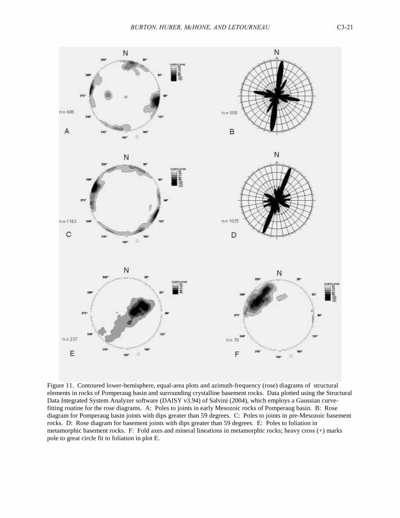
The results (Fig. 11) show that the most prominent joint orientation for both the Pomperaug basin rocks and the
crystalline basement rocks is NNE and subvertical, with the strike of this trend in the crystalline rocks (Fig. 11D)
about 14 degrees to the east of the Pomperaug trend (Fig. 11B). The Pomperaug basin joints also form a secondary
peak trending WNW, orthogonal to the primary peak, and a tertiary peak trending NE (Fig. 11A, B). Less prominent
joint orientations in the crystalline rocks show a more uniform distribution, among which are peaks that correspond
to the secondary and tertiary peaks in the Pomperaug basin rocks (Fig. 11C, D).
The NNE major joint trend in the Pomperaug basin rocks fits well with the extensional tectonic environment
during basin formation, and it is approximately parallel to the long axis of the basin. A major question is whether
the NNE trend is Mesozoic in age. In his detailed study of the crystalline rocks of the New Milford 7.5-minute
quadrangle, less than 20 km to the west, Walsh (2004) divided the map area into 17 domains and showed that the
dominant joint trends in each domain are generally east-west and orthogonal to foliation, which has a regional strike
of about N-S. In several of these domains secondary or tertiary peaks trend in a NNE direction similar to that of the
crystalline rocks around the Pomperaug basin. These peaks, however, are mostly due to foliation-parallel parting
joints, which are well-developed in the New Milford quadrangle (Walsh, 2004). In the Pomperaug basin area the
mean foliation strike in the crystalline rocks is about due northwest (Fig. 11E), and foliation-parallel parting joints
are not well developed and probably do not account for any of the principle joint trends. A principle joint trend
orthogonal to foliation, similar to that found in the New Milford quadrangle, would produce a peak trending roughly
due NE, or more easterly than the one determined for the Pomperaug area rocks. Therefore the NNE principle joint
trend determined for the crystalline rocks is here proposed to be Mesozoic in origin as well, perhaps slightly
refracted into a trend more orthogonal to the prevailing foliation. This trend is also nearly parallel to the third-most
prominent trend in the Mesozoic rocks (Fig. 11B), and may be a hybrid of that as well.
BURTON, HUBER, McHONE, AND LETOURNEAU C3-21
Figure 11. Contoured lower-hemisphere, equal-area plots and azimuth-frequency (rose) diagrams of structural
elements in rocks of Pomperaug basin and surrounding crystalline basement rocks. Data plotted using the Structural
Data Integrated System Analyzer software (DAISY v3.94) of Salvini (2004), which employs a Gaussian curve-
fitting routine for the rose diagrams. A: Poles to joints in early Mesozoic rocks of Pomperaug basin. B: Rose
diagram for Pomperaug basin joints with dips greater than 59 degrees. C: Poles to joints in pre-Mesozoic basement
rocks. D: Rose diagram for basement joints with dips greater than 59 degrees. E: Poles to foliation in
metamorphic basement rocks. F: Fold axes and mineral lineations in metamorphic rocks; heavy cross (+) marks
pole to great circle fit to foliation in plot E.
BURTON, HUBER, McHONE, AND LETOURNEAU C3-22
Another question raised by the joint data is the origin of the WNW principle trend in the Pomperaug basin
rocks, which is flanked by two lesser trends to the north and south, respectively (Fig. 11B). Such a joint trend
suggests east-west compression or north-south extension; i.e. a stress field that is rotated 90 degrees from the one
that produced the basin. Perhaps the presence of this principle joint trend is another indication of post-early
Mesozoic compression, or inversion, of the Pomperaug basin. These joint trends appear to be present as well in the
crystalline rocks, but reversed in prominence, with the northern of the three trends most dominant and the middle
trend the least dominant. This disparity could be explained by the fact that the joint measurements in the crystalline
rocks are nearly twice as numerous as the basin rocks, and undoubtedly reflect the influence of one or more pre-
Mesozoic events in addition to the Mesozoic and post-Mesozoic (?) events. In addition, the compressive event that
produced the WNW joint trend, if indeed the cause, would have had less of an effect on the crystalline rocks than the
relatively weak basin rocks.
ORIGIN OF THE POMPERAUG BASIN
Sources for basalts and sediments
There are three models that attempt to explain the origin of the early Mesozoic Pomperaug basin: (1) it is a
separate extensional basin on a par with its much larger neighbors the Hartford and Newark basins, with its own
distinct depositional sources and tectonic history (Huber and McDonald, 1992; Huber, 1996); (2) it is a down-
faulted remnant of the central area of a much larger, regional basin structure (a deeply eroded anticline) whose
original extent is defined by the present eastern and western border faults of the Hartford and Newark basins,
respectively (the Broad Terrane model of Russell, 1892; Sanders, 1960); and (3) it is an erosional outlier that
represents the “feather edge” of an originally much larger Hartford basin, preserved by post-depositional
downfaulting (the modified Broad Terrane model of Krynine, 1950; Hubert et. al., 1978). Because of the
stratigraphic and geochemical similarities between the Pomperaug basin and the Hartford basin, either variant of the
Broad Terrane model has been adopted by many workers over the past 150 or more years, e.g. Percival (1842);
Sanders and others (1974; 1981); Hubert and others (1979), Weddle and Hubert (1983); McHone (1996). An
additional hypothesis has been put forth recently by Blevins-Walker et al. (2001) and Wintsch et al. (2003) that
considers the Hartford and Pomperaug basins to be merely the preserved portions of a large, low-relief, regional
foreland basin that encompassed much of southern New England during the Permian through Cretaceous, thus
rejecting an extensional tectonic origin for the individual basins.
The evidence presented here suggests that another model, intermediate between the modified broad terrane and
isolated basin models, might be more realistic. In our opinion, the Pomperaug basin is not entirely a local basin with
local sources; nor is it merely the downfaulted remnant of a once-much larger basin. Apart from the overall gross
similarity in lithostratigraphy (which itself is as much the product of regional long term, Milankovich-driven
paleoclimatic fluctuations as of tectonism), two lines of evidence most strongly link the Pomperaug basin with the
Hartford basin. The first is basalt geochemistry: the East Hill and Orenaug Basalts plot close to the same
geochemical fields as the “first” and “second” basalts, respectively, of the Hartford and Newark basins, suggesting
that the East Hill and Orenaug Basalts are in fact distal portions of the Talcott and Holyoke Basalts, respectively.
However, the two geochemical analyses of the “third” basalt of the Pomperaug basin (South Brook Basalt) that we
have do not fall into the fields for Hampden Basalt or the other basalts. Their consistent grouping together on
various discrimination diagrams suggests that this difference could be real and not due to sample alteration, and
implies, perhaps, a magma source separate from those that fed the Hartford basin basalts. After all, the basalts of the
widely separated Newark and Hartford basins, despite their similarities in chemistry and timing of eruption, possibly
flowed from separate vents — could not the same be argued for the third Pomperaug basalt? However, we note the
absence of any vents and source dikes in Connecticut other than those identified as feeders to the main basalts of the
Hartford basin (Philpotts and Martello, 1986).
Basalts of the Pomperaug basin could therefore represent a combination of distal and local sources. For
instance, the eruptive centers for Talcott magma were located within the southern and east-central Hartford basin,
within 30 km of the Pomperaug basin (Olsen et al., 2003; Huber et al., 2005). Conceivably, Talcott lava could have
advanced westward from the Hartford basin, along the topographic low areas of the regional drainage network, as
far as the Pomperaug basin. Some support for this concept comes from regional thickness data for Talcott-East Hill
extrusive volcanic rocks, which are 20 m-thick or less hyaloclastic breccias in areas adjacent to the Hartford basin
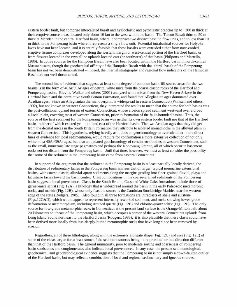
BURTON, HUBER, McHONE, AND LETOURNEAU C3-23
eastern border fault, but comprise intercalated basalt and hyaloclastic and pyroclastic breccias up to ~300 m thick at
their eruptive source areas, located only about 10 km to the west within the basin. The Talcott Basalt thins to 50 m
thick at Meriden in the central Hartford basin, where it comprises two distinct basaltic flow units, and to less than 10
m thick in the Pomperaug basin where it represents a single flow unit. Potential intrabasinal sources for Holyoke
lavas have not been located, and it is entirely feasible that these basalts were extruded either from now-eroded,
eruptive fissure complexes developed along the western margin or west-central portion of the Hartford basin, or
from fissures located in the crystalline uplands located east (or southwest) of that basin (Philpotts and Martello,
1986). Eruptive sources for the Hampden Basalt have also been located within the Hartford basin, in north-central
Massachusetts, though the geochemical affinity of the Hampden Basalt with the “third” basalt of the Pomperaug
basin has not yet been demonstrated -- indeed, the internal stratigraphy and regional flow indicators of the Hampden
Basalt are not well-documented.
The second line of evidence that suggests at least some degree of common basin-fill source areas for the two
basins is in the form of 40Ar/39Ar ages of detrital white mica from the coarse clastic rocks of the Hartford and
Pomperaug basins. Blevins-Walker and others (2001) analyzed white micas from the New Haven Arkose in the
Hartford basin and the correlative South Britain Formation, and found that Alleghanian ages dominated over
Acadian ages. Since an Alleghanian thermal overprint is widespread in eastern Connecticut (Wintsch and others,
1992), but not known in western Connecticut, they interpreted the results to mean that the source for both basins was
the post-collisional upland terrain of eastern Connecticut, whose erosion spread sediment westward over a broad
alluvial plain, covering most of western Connecticut, prior to formation of the fault-bounded basins. Thus, the
source of the first sediment for the Pomperaug basin was neither its own eastern border fault nor that of the Hartford
basin--neither of which existed yet—but land east of the Hartford basin. The two Acadian ages that they did get
from the detrital micas in the South Britain Formation they attribute to isolated monadnocks in the alluvial plain in
western Connecticut. This hypothesis, relying heavily as it does on geochronology to overrule other, more direct
lines of evidence for local sedimentation, would require for confirmation a more extensive collection of not only
white mica 40Ar/39Ar ages, but also an updated geochronology of certain rock bodies in western Connecticut, such
as the small, numerous late stage pegmatites and perhaps the Nonewaug Granite, all of which occur in basement
rocks not too distant from the Pomperaug basin. Until that time, however, we must at least consider the possibility
that some of the sediment in the Pomperaug basin came from eastern Connecticut.
In support of the argument that the sediment in the Pomperaug basin is at least partially locally derived, the
distribution of sedimentary facies in the Pomperaug basin mirrors that of larger, typical nonmarine extensional
basins, with coarse-clastic, alluvial-apron sediments along the margins grading into finer-grained fluvial, playa and
lacustrine facies toward the basin center. Clast compositions in the coarse-grained sediments of the Pomperaug
basin suggest a local provenance. Clasts in the South Britain, Cass and White Oaks formations include those of
garnet-mica schist (Fig. 12A), a lithology that is widespread around the basin in the early Paleozoic metamorphic
rocks, and marble (Fig. 12B), whose only feasible source is the Cambrian Stockbridge Marble, near the western
edge of the state (Rodgers, 1985). Also found in all three formations are intraclasts of shale and siltstone
(Figs.12C&D), which would appear to represent internally reworked sediment, and rocks showing lower-grade
deformation or metamorphism, including strained quartz (Fig. 12E) and chlorite-quartz schist (Fig. 12F). The only
source for low-grade metamorphic rocks in Connecticut at the present land surface is the Orange-Milton belt, about
20 kilometers southeast of the Pomperaug basin, which occupies a corner of the western Connecticut uplands from
Long Island Sound northeast to the Hartford basin (Rodgers, 1985); it is also plausible that these clasts could have
been derived more locally from less-deeply-buried metamorphic rocks that have long since been removed by
erosion.
Regardless, all of these lithologies, along with the extremely elongate shape (Fig. 12C) and size (Fig. 12E) of
some of the clasts, argue for at least some of the sediment sources being more proximal or in a direction different
than that of the Hartford basin. The general immaturity, poor to moderate sorting and coarseness of Pomperaug
basin sandstones and conglomerates also indicate local provenances. In any case, the present sedimentological,
geochemical, and geochronological evidence suggests that the Pomperaug basin is not simply a down-faulted outlier
of the Hartford basin, but may reflect a combination of local and regional sedimentary and igneous sources.
BURTON, HUBER, McHONE, AND LETOURNEAU C3-24
Figure 12. Clasts in conglomerate in South Britain (A) and White Oaks (B-F) formations. A: garnet-muscovite-
biotite schist. B: foliated marble. C: shale chip. D: interbedded siltstone and shale. E: strained quartz. F: chlorite-
quartz schist.
Size and location of the basin
Why is the Pomperaug basin so small? Evidence from the larger early Mesozoic basins suggest that their
primary border faults formed through tectonic reactivation of pre-existing Paleozoic structures (Schlische, 1993):
BURTON, HUBER, McHONE, AND LETOURNEAU C3-25
e.g., the western border fault of the Newark basin formed from southeast-dipping Paleozoic thrust faults (Ratcliffe
and Burton, 1985), the eastern border fault of the Hartford basin formed along the west-dipping west limb of the
Bronson Hill anticlinorium (Rodgers, 1985; Wintsch and others, 2003), and the western border fault of the Culpeper
and Gettysburg basins formed along the east-dipping east limb of the Blue Ridge-South Mountain anticlinorium
(Southworth and others, 2000). In contrast, the NNE-trending eastern border fault of the Pomperaug basin clearly
cuts across the structural grain of northwest-trending Paleozoic contacts and metamorphic foliation (Fig. 1); no
known older fabrics parallel the border fault. We propose that the Pomperaug basin is so small because there were
no pre-existing structures in favorable orientations that could facilitate fault development and opening of the basin—
it is therefore “the exception that proves the rule” about tectonic inheritance and early Mesozoic extension. Its small
size is probably also related to its position between the large Hartford and Newark basins, where most of the major
regional extension would be accommodated (Olsen and Schlische, 1988). However, the late-faulting model (model
3 presented above) is harder to justify for the same positional argument: why would extensional faults develop in an
unfavorable area after adjacent, much larger zones of extension are already well-established? Clearly the “why” of
the Pomperaug basin is not easily answered.
PRE-MESOZOIC ROCKS
William C. Burton
The Pomperaug basin is underlain by schists, gneisses, and granitic rocks of early Paleozoic age that were
metamorphosed during the Acadian orogeny (Scott, 1974; Stanley and Caldwell, 1976; Rodgers, 1985). In the
present study these rocks were mapped out to a distance of about 2 km from the basin margin. The twin goals of
this portion of the study were to try to understand the nature of the response of the crystalline basement rocks to the
crustal extension associated with basin formation, discussed in the previous section, and to shed new light on the
Paleozoic deformational history of the rocks. Consequently, ductile structures were mapped along with the brittle
structures, including several generations of foliation and folds, and mineral and intersection lineations.
Lithologies
Most of the basement rocks can be described as northwest-trending, several-kilometer-wide belts of metapelitic
schist and gneiss, with only subtle compositional and textural differences between belts. These differences include
grain size, color, nature of foliation, and the relative abundances of common minerals such as muscovite, biotite, and
garnet. The map units were mapped using these criteria and then reconciled as well as possible with the map units
on the Bedrock Geological Map of Connecticut (Rodgers, 1985). The resulting interpretation is shown on Fig. 1.
Thin elongate, mappable bodies of amphibolite, calc-silicate rock, quartzite, and other primary lithologies were
mapped within many of these units, as well as sills of foliated granite and pegmatite. The new map differs from the
state geologic map in that quartz-rich Ratlum Mountain schist (Or, Fig. 1; Stop 3) extends southeast of the
Pomperaug basin, through an area previously mapped by Scott as “Hartland II” (Rowe on the state map), and
interlayered Taine Mountain and Collinsville formations. In the new interpretation the Taine and Collinsville
formations are kept separate, with Taine Mountain (Ot, Fig. 1) entirely northeast of a belt of Collinsville Formation
(Oc, Fig. 1), which forms an overturned syncline with a thin belt of The Straits Schist (Dst, Fig. 1) at its core. The
Taine Mountain formation is underlain to the northeast by basal Taine Mountain (Otb, Fig. 1), which just east of the
map area directly overlies the Waterbury Gneiss in the core of the Waterbury Dome, according to Rodgers (1985).
An early (D1?) thrust fault is hypothesized for the contact between Collinsville Formation and Ratlum Mountain
Formation, separating the sequence of rocks connected to the Waterbury Dome (Collinsville Fm./Taine Mountain
Fm./Waterbury Gneiss) from Rowe and Ratlum Mountain schist. The extension of this fault northwest of the basin
is instead occupied by a previously unmapped, 2-km wide body of foliated two-mica granite (Fig. 1, Stop 4). This
granite, as well as the smaller granitic sills mapped northwest of the basin, is perhaps comagmatic with the intrusive
body north of the basin mapped as Nonewaug Granite by Gates (1954), although the latter is actually a series of
pegmatite bodies (Robert Tracy, oral comm., 2005). The metamorphic grade of all these rocks is upper amphibolite
facies, as represented by kyanite-bearing mineral assemblages, as well as lesser sillimanite- and staurolite-bearing
assemblages.
Tectonic models
As previously mentioned, the basement rocks underlying the Pomperaug basin are distributed in northwest-
striking lithologic belts, despite the fact that in a very broad sense the metamorphic formations of western
BURTON, HUBER, McHONE, AND LETOURNEAU C3-26
Connecticut trend north-south or northeast-southwest. Within each belt are folds ranging from map scale, as outlined
by amphibolite and kyanite schist layers mapped in the Rowe, Ratlum Mountain, and Collinsville formations (Fig.
1), to outcrop scale, as shown by tight to isoclinal to locally rootless folds of amphibolite and granofels layers within
the schists. The thin, northwest-trending belt of The Straits Schist (Dst, Fig. 1) within the Collinsville Formation
(Oc, Fig. 1) was considered by Scott (1974) to represent the nose of an early-stage, east-facing synclinal nappe that
trended north-northeast across the present position of the Waterbury dome.
Also widespread in the map area, particularly in the south and west, is a prominent, gently northwest-plunging
lineation, expressed in outcrop by the hinges of minor folds and on foliation surfaces by mineral elongation
directions (Fig. 11F). Despite the fact that they mapped the same generation of folds and lineations in adjacent
quadrangles, Scott (1974) and Stanley and Caldwell (1976) had very different ideas as to the origin of these
structures. Scott (1974) thought that all of the northwest-trending structures, including contacts, dominant
schistosity, fold hinges, and lineations were produced during formation of the Waterbury Gneiss dome just to the
northeast, which in his model represented the fourth major phase of folding in the region, all phases of which were
Acadian in age. The doming produced a “pinching” of rocks on the dome flanks or a “draping of the rocks off the
dome,” and resulted in the formation of these structures tangential to the dome. The lineations were of his “Period-
4” generation, and accompanied northwest-trending, map-scale, upright folds (Plate 1 in Scott, 1974) that produced
the alternating belts of Taine Mountain and Collinsville formations as shown on the Bedrock Geologic Map of
Connecticut (Rodgers, 1985).
In contrast, Stanley and Caldwell (1976) considered the lineations and co-linear fold hinges to represent the
second phase of folding (F2) in the area, which predated doming, accompanied Acadian peak metamorphism, and
produced west-plunging (present orientation) tight to isoclinal folds, and accompanying north- to northwest-striking,
west-dipping axial-planar schistosity that is the dominant foliation in the region. These second-generation folds
strongly deform an older, larger, nappe-stage F1 fold of uncertain original orientation and possibly of Taconian age,
producing a very complex “jelly roll” structure (Figure 10 in Stanley and Caldwell, 1976). The F2 movement
direction may locally have been south over north, based on the rotation sense of minor folds in a calc-silicate layer
just northwest of South Britain (Stanley and Caldwell, 1976). However, their cross-section A-A,’ drawn normal to
the west-plunging fold axes, does not suggest a dominant overall rotation sense (Plate 2 in Stanley and Caldwell,
1976). They also recognized a post-peak-metamorphic Acadian F3 fold generation, and a late, F4 generation
associated with retrograde, chlorite-bearing mineral assemblages that may represent effects of the Alleghanian
orogeny (Stanley and Caldwell, 1976).
Based on the recent mapping around the Pomperaug basin, we agree with the Stanley and Caldwell (1976)
model that the dominant structures in outcrop, including minor folds, lineations and schistosity, are second
generation (S2/F2) in age, formed under peak metamorphic conditions, and are indicative of tight to isoclinal, minor
to map-scale, west-plunging folds. It is possible, however, that the west to northwest-plunging lineations and fold
hinges indicate transport direction, either up from the west, or up from the east and overturned by later folding. A
first-generation foliation (S1) is also thought to be represented by locally preserved, fine-grained compositional
layering—although F1 folds have not yet been recognized--and F3 folds locally form crenulations and kink folds in
F2 schistosity. Many questions remain, particularly concerning the respective roles of the Taconian and Alleghanian
orogenies, and more work is planned in the less-well-mapped Roxbury and Woodbury quadrangles, to the north of
the quadrangles mapped by Scott (1974) and Stanley and Caldwell (1976), and just east of the New Milford
quadrangle recently mapped by Walsh (2004).
ACKNOWLEDGMENTS
We thank Larry Pond, the Griswold family, and the Pomperaug River Watershed Coalition for their support of
the USGS studies in the Pomperaug basin. Thanks also to Claudia Tamayo for her efforts in compiling well data
that was crucial to construction of the geologic map, and to Boris Barrios for digital compilation of the map data.
O&G Industries, Inc. through the efforts of Ken Faroni kindly provided access to the traprock quarries. P. Huber
and P. M. LeTourneau thank Alta Huber of Southbury for assistance in the field and logistical support. Field work
by J. G. McHone for basalt studies was sponsored by a contract with the State Geological and Natural History
Survey of Connecticut, as suggested and assisted by Ralph Lewis. The new geologic mapping was made possible by
the USGS National Cooperative Geologic Mapping Program.
BURTON, HUBER, McHONE, AND LETOURNEAU C3-27
REFERENCES
Ahlbrandt, T. S., 1979, Textural parameters of eolian deposits, in McKee, E. D., ed., A Study of Global Sand Seas:
U.S. Government Printing Office, Washington, 1052: 21-51
Barrell, J., 1915, Central Connecticut in the geologic past: Connecticut Geological and Natural History Survey Bulletin, no.
23, 44 p.
Blevins-Walker, J., Kunk, M. J., and Wintsch, R. P., 2001, An eastern provenance for the New Haven Arkose and the
Portland Formation of the Hartford and Pomperaug basins: Broad Terrane revisited: Geological Society of America
Abstracts with Program, Northeastern Section, v. 33, no. 1, p. 81.
Bates, R. L., and Jackson, J. A., eds., 1980, Glossary of Geology, 2nd
edition: American Geological Institute, Falls Church,
Virginia, 749 p.
Chapman, R. W., 1965, Stratigraphy and petrology of the Hampden basalt in central Connecticut: Connecticut Geological
and Natural History Survey Report, no. 3, 38 p.
Cornet, Bruce, 1977, The palynostratigraphy and age of the Newark Supergroup: unpub. Ph.D. dissertation, Pennsylvania
State University, University Park, 505 p.
Davis, W. M., 1888, The Triassic formation of the Connecticut Valley: U.S. Geological Survey, 7th
Ann. Report, p. 468-490.
Davis, W. M., 1898, The Triassic formation of Connecticut: U. S. Geological Survey Annual Report, no. 18, part 2, p. 1-192.
Ellefson, K. J. and Rydel, P. L., 1985, Flow direction of the Hamden basalt in the Hartford basin, Connecticut and southern
Massachusetts: Northeastern Geology, v. 7, p. 33-36.
Fryberger, S. G. and Schenk, C. J., 1988, Pin stripe lamination: A distinctive feature of modern and ancient eolian sediments:
Sedimentary Geology, vol. 55, p. 1-15.
Garabedian, J. A., Gray, N. H., and Steinen, R. P., 1996, Secondary minerals in half-moon vesicles of the Mesozoic basalts of
the Pomperaug basin, in LeTourneau, P. M. and Olsen, P. E., eds., Aspects of Triassic-Jurassic Rift Basin Geoscience:
State Geological and Natural History Survey of Connecticut Miscellaneous Reports, no. 1, p. 13.
Gates, R. M., 1959, Bedrock geology of the Roxbury quadrangle, Connecticut: U.S. Geological Survey Geologic Quadrangle
Map GQ-121, scale 1:24,000.
Gates, R. M., 1954, The bedrock geology of the Woodbury quadrangle, Connecticut: State Geological and Natural History
Survey of Connecticut Quadrangle Report no. 3, 32 p.
Gottfried, D., Froelich, A. J., and Grossman, J. N., 1991, Geochemical data for Jurassic diabase associated with Early
Mesozoic basins in the eastern United States: Geologic setting, overview, and chemical methods used: U. S. Geological
Survey Open-File Report 91-322-A.
Grossman, J. N., Gottfried, D., and Froelich, A. J., 1991, Geochemical data for Jurassic diabase associated with Early
Mesozoic basins in the eastern United States: U. S. Geological Survey Open-File Report 91-322-K.
Gray, N. H., 1982, Mesozoic volcanism in north-central Connecticut, in Joesten. R. and Quarrier, S., eds., Guidebook for
field trips in Connecticut and south central Massachusetts: Hartford, State Geological and Natural History Survey of
Connecticut Guidebook No. 5, p. 173-190.
Hames, W.E., Renne, P. R., and Ruppel, C., 2000, New evidence for geologically-instantaneous emplacement of earliest
Jurassic Central Atlantic magmatic province basalts on the North American margin: Geology, v. 28, p. 859-862.
Hitchcock, Edward, 1828, Miscellaneous notices of mineral localities, with geological remarks: American Journal of Science,
series 1, v. 14, p. 215-230.
Hobbs, W. H., 1901, The Newark system of the Pomperaug Valley, Connecticut: U.S. Geological Survey Annual Report no.
21, pt. 3, 162 p.
Horne, G. S., McDonald, N. G., LeTourneau, P. M., and de Boer, J. Z., 1995, Paleo-environmental traverse across the Early
Mesozoic Hartford basin, Connecticut: State Geological and Natural History Survey of Connecticut Guidebook, no. 7, p.
B1-B37.
Hovey, E. O., 1890, The oil well at Southbury, Connecticut: Scientific American, vol. 62, p. 275.
Hozik, M. J., 1992, Paleomagnetism of igneous rocks in the Culpeper, Newark, and Hartford/Deerfield basins, in Puffer J. H.
and Ragland, P. C., eds., Eastern North American Mesozoic Magmatism: Geological Society of America Special Paper
268, p. 279-308.
Huber, P., 1997, Comment: Broad-terrane Jurassic flood basalts across northeastern North America: Geology, v. 25, p. 191-
192.
Huber, P. and McDonald, N. G., 1992, Revised stratigraphy and paleontology of the Early Mesozoic Pomperaug basin
(Newark Supergroup), western Connecticut: Geological Society of America Abstracts with Program, vol. 24, no. 7, p.
357-358.
BURTON, HUBER, McHONE, AND LETOURNEAU C3-28
Huber, P., Whiteside, J. H., and Olsen, P. E., 2005, Lithostratigraphy of Triassic-Jurassic boundary and lowermost
Jurassic rocks, Hartford basin, southern New England: Geological Society of America Abstracts with
Programs, vol. 37, no. 5, p. 78.
Hubert, J. F., Reed, A. A., Dowdall, W. L. and Gilchrist, J. M, 1978, Guide to the Mesozoic redbeds of central
Connecticut: State Geological and Natural History Survey of Connecticut Guidebook, no. 4, 129 p.
Hunter, R. E., 1977, Terminology of cross-stratified sedimentary layers and climbing-ripple structures: Journal of
Sedimentary Petrology, vol. 47, no. 2, p. 697-706.
Hurtubise, D. O. and Puffer, J. H., 1983, Geochemistry and petrology of the Pomperaug basin basalts, Connecticut [abstract]:
Geological Society of America Abstracts with Program, vol. 15, no. 1, p. 91.
Klein, G. deV., 1969, Deposition of Triassic sedimentary rocks in separate basins, eastern North America: Geological Society
of America Bulletin, v. 80, p. 1825-1832.
Kocurek, G. and Dott, R. H., Jr., 1981, Distinctions and uses of stratification types in the interpretation of eolian
sand: Journal of Sedimentary Petrology, vol. 51, no. 2, p. 579-595.
Krynine, P. D., 1950, Petrology, stratigraphy, and origin of the Triassic sedimentary rocks of Connecticut: Connecticut
geological and Natural History Survey Bulletin, no. 73, 247 p.
LeBas, M. J., LeMaitre, R. W., Streckeisen, A., and Zanettin, B., 1986, A chemical classification of volcanic rocks based on
the total alkali silica diagram: Journal of Petrology, v. 27, p. 745-750.
LeTourneau, P. M. and Huber, P., 1997, Early Jurassic rift basin eolian strata, Pomperaug basin, Newark Supergroup,
Connecticut: Geological Society of America Abstracts with Program, vol. 29, no. 1, p. 61.
LeTourneau, P. M., 2002, Eolian sandstones from the Pomperaug and Hartford rifts, Connecticut: Indicators of Early Jurassic
paleoclimate gradients?: Geological Society of America Abstracts with Program, Northeastern Section, v. 34, p. 51.
LeTourneau, P. M. and Huber, P., in review, Geology of the Triassic-Jurassic Pomperaug basin, western Connecticut:
Implications for Newark Supergroup paleoclimatic and paleogeographic reconstruction models, for S. G. Lucas and
others, eds., Nonmarine Triassic-Jurassic Transition, New Mexico Museum of Natural History Bulletin.
Longwell, C.R., 1933, New Haven, Connecticut to New York: in Longwell, C.R., ed., Eastern New York and western New
England: International Geological Congress, 16th
Session, United States, Guidebook 1, Excursion A-1, p. 116-118.
Longwell, C., 1922, Notes on the structure of the Triassic rocks in southern Connecticut: American Journal of Science, vol. 4,
no. _, p. 223-236.
Lorenz, J. C., 1988, Triassic-Jurassic rift basin sedimentology - history and methods: New York, Van Nostrand Reinhold,
315 p.
Lucas, S. G. and Huber, P., 2003, Vertebrate Biostratigraphy of the Nonmarine Late Triassic, in LeTourneau, P. M. and
Olsen, P. E., eds., The great rift valleys of Pangea in eastern North America, vol. 2: New York, Columbia University
Press, p. 143-191.
Margolis, Robinson and Schafer, 1986, Annotated bibliography of studies on the geology, geochemistry, mineral resources,
and geophysical character of the early Mesozoic basins of the eastern United States, 1880 – 1984: USGS Bulletin 1688.
Mazzaferro, D. L., 1986, Ground-water availability and water quality at Southbury and Woodbury, Connecticut: U.S.
Geological Survey Water Resources Investigations Report 84-4221.
McDonald, N. G., 1982, Fossil fishes from the Newark Group of the Connecticut Valley: unpub. M. S. thesis, Wesleyan
University, Middletown, Connecticut, 230 p.
McDonald, N. G., 1996, The Connecticut Valley in the Age of Dinosaurs: A Guide to the Geologic Literature, 1681-1995:
Connecticut Geologic and Natural History Survey Bulletin, no. 116, 242 p.
McHone, J. G, 1996, Broad-terrane Jurassic flood basalts across northeastern North America: Geology, v. 24, p. 319-322.
McHone J. G., 2000, Non-plume magmatism and rifting during the opening of the Central Atlantic Ocean: Tectonophysics,
v. 316, p. 287-296.
McHone, J. G., 2003a, Volatile emissions from Central Atlantic Magmatic Province basalts: Mass assumptions and
environmental consequences, in Hames, W. E., McHone, J. G., Renne, P., and Ruppel, C., eds., The Central Atlantic
Magmatic Province: Insights from Fragments of Pangea: American Geophysical Union Monograph, no. 136, p. 241-254.
McHone, J.G., 2003b, Early Mesozoic basalts of the Pomperaug basin, southwestern Connecticut: Regional, stratigraphic,
and petrologic features: State Geological and Natural History Survey, Open File Report, 40 p.
McHone, J. G., and Puffer, J. H., 2003, Flood basalt provinces of the Pangaean Atlantic rift: Regional extent and
environmental significance, in LeTourneau, P. M. and Olsen, P. E., eds., The great rift valleys of Pangea in eastern North
America, vol. 1: New York, Columbia University Press, p. 141-154.
McKee, E. D. and Weir, G. W., 1953, Terminology for stratification and cross-stratification in sedimentary rocks:
Geological Society of America Bulletin, vol. 64, p. 381-390.
Mikami, H. M. and Digman, R. E., 1957, The bedrock geology of the Guilford 15-minute quadrangle and a portion of the
New Haven quadrangle: State Geological and Natural History Survey of Connecticut Bulletin, no. 86, 99 p.
BURTON, HUBER, McHONE, AND LETOURNEAU C3-29
Meinzer, O. E. and Sterns, N. D., 1929, A study of groundwater in the Pomperaug basin, Connecticut, with special reference
to intake and discharge: U. S. Geological Survey Water Supply Paper, no. 597-B, p. 73-146.
Olsen, P. E., 1997, Stratigraphic record of the early Mesozoic breakup of Pangea in the Laurasia-Gondwana rift system:
Annual Reviews of Earth and Planetary Sciences, v. 25, p. 337-401.
Olsen, P. E., McCune, A. R., and Thomson, K. S., 1982, Correlation of the Early Mesozoic Newark Supergroup by
vertebrates, principally fishes: American Journal of Science, vol. 282, p. 1-44.
Olsen, P. E., Whiteside, J. H., and Huber, P. 2003, Causes and consequences of the Triassic-Jurassic mass extinction as seen
from the Hartford basin, in Brady, J. B. and Cheney, J. T., eds., Guidebook for field trips in the Five College region, 95th
Annual Meeting of the New England Intercollegiate Geological Conference, Trip B5, p. 1-41.
Olsen, P. E. and Schlische, R. W., 1987, Paired half-graben, crustal collapse graben - examples from the Early Mesozoic of
Eastern North America. Geological Society of America, Abstracts with Programs., v. 19(7), p 794.
Olsen, P. E., Schlische, R. W., and Fedosh, M. S., 1996, 580 Ky duration of the early Jurassic flood basalt event in eastern
North America estimated using Milankovich cyclostratigraphy: Museum of Northern Arizona Bulletin, no. 60, p. 11-22.
Percival, J. G., 1842, Report on the geology of the State of Connecticut: New Haven, Osborne and Baldwin, p. 308-451.
Philpotts, A. R., Carroll, M., and Hill, J. M., 1996, Crystal-mush compaction and the origin of pegmatitic segregation sheets
in a thick flood-basalt flow in the Mesozoic Hartford basin, Connecticut: Journal of Petrology, vol. 97, p. 811-836.
Philpotts, A. R. and Martello, A., 1986, Diabase feeder dikes for the Mesozoic basalts in southern New England: American
Journal of Science, vol. 286, p. 105-126.
Philpotts, A. R. and McHone, J. G., 2003, Basaltic sills, dikes, and lavas in the Hartford basin, Connecticut, in Brady, J. B.
and Cheney, J. T., eds., Guidebook for Field Trips in the Five College Region: New England Intercollegiate Geological
Conference, 95th
Annual Meeting, Amherst and Northampton, Massachusetts, p. C2-1-C2-30.
Philpotts, A.R. and Reichenbach, I., 1985, Differentiation of Mesozoic basalts of the Hartford basin, Connecticut: Geological
Society of America Bulletin, vol. 96, p. 1131-1139.
Puffer, J. H., 1994, Initial and secondary Pangaean basalts, in Pangaea: Global Environments and Resources: Canadian
Society of Petroleum Geology Memoir, no. 17, p. 85-95.
Puffer, J. H., 1992, Eastern North American flood basalts in the context of the incipient breakup of Pangaea, in Puffer J. H.
and Ragland, P. C., eds., Eastern North American Mesozoic Magmatism: Geological Society of America Special Paper
268, p. 95-118.
Puffer, J. H., Hurtubise, D. O., Geiger, F. J., and Lechler, P., 1981, Chemical composition and stratigraphic correlation of
Mesozoic basalt units of the Newark Basin, New Jersey, and the Hartford basin, Connecticut: Geological Society of
America Bulletin, vol. 92, p. 155-159.
Ratcliffe, N. M. and Burton, W. C., 1985, Fault reactivation models for origin of the Newark basin and studies related to
eastern U.S. seismicity, in Robinson, Gilpin R. and Froelich, Albert J., eds., Proceedings of the Second USGS Workshop
on the Early Mesozoic Basins of the Eastern U.S.: U.S. Geological Survey Circular 946, p. 36-45.
Rodgers, J., 1985, Bedrock geological map of Connecticut: Connecticut Geological and Natural History Survey, scale
1:125,000, 2 sheets.
Rodgers, J., Bates, R. M., and Rosenfeld, J. L., 1959, Explanatory text for preliminary geological map of Connecticut, 1956:
Hartford, State Geological and Natural History Survey, Bull. 84, 64 p.
Russell, L.C., 1892, Correlation papers: The Newark System: U.S. Geological Survey Bulletin 85, 344 p.
Russell, I. C. 1880. On the former extent of the Triassic formation of the Atlantic states. American Naturalist, v. 14, p. 703-
712.
Sanders, J. E., 1974, Guidebook to field trip in Rockland County, New York: Petroleum Exploration Society of New York.
Sanders, J., 1970, Stratigraphy and structure of the Triassic strata of the Gaillard graben, south-central Connecticut:
Connecticut Geological and Natural History Survey Guidebook, no. 3, 15 p.
Sanders, J., 1963, Late Triassic tectonic history of northeastern United States: American Journal of Science, v. 261, p. 501-
524.
Sanders, J. E., 1960, Structural history of Triassic rocks of the Connecticut Valley belt and its regional implications: New
York Academy of Science – Transactions, vol. 23, Series 2, p. 119-132.
Schenk, C. J., 1990, Processes of eolian sand transport and deposition, in Fryberger, S. G., Krystinik, L. F., and Schenk, C. J.,
eds., Modern and ancient eolian deposits: Petroleum exploration and production: Rocky Mountain Section SEPM: 21-29.
Schlische, R.W., 1993, Anatomy and evolution of the Triassic-Jurassic continental rift system, eastern North America:
Tectonics, v. 12, p. 1026-1042.
Schutz, D. F., 1956, The geology of Pomperaug Valley, Connecticut: unpub. senior paper, Department of Geology, Yale
University, New Haven, Connecticut, 44 p.
Scott, R. B., 1974, The bedrock geology of the Southbury quadrangle, with map: State Geological and Natural History
Survey of Connecticut Quadrangle Report, no. 30, 63 p.
BURTON, HUBER, McHONE, AND LETOURNEAU C3-30
Silliman, Benjamin, 1820, Sketches of a tour in the counties of New Haven and Litchfield in Connecticut, with notices of the
geology, mineralogy, and scenery, etc.: American Journal of Science, series 1, vol. 2, p. 201-235.
Smoot, J. P., 1991, Sedimentary facies and depositional environments of early Mesozoic Newark Supergroup basins, eastern
North America: Paleogeogeography, Paleoclimatology, Paleoecology, vol. 84, p. 369-423.
Stanley, R. S., and Caldwell, K. G., 1976, The bedrock geology of the Newtown quadrangle, with map: State Geological and
Natural History Survey of Connecticut Quadrangle Report, no. 33, 43 p.
Thomas, M. A., 1983, Effect of cooling rate and magma oxidation state on pyroxene chemical trends in a tholeiitic basalt:
Geological Society of America Abstracts with Program, v. 15, no. 3, p. 173.
Tillman, J. E., 1982, Major fault zones and related seismicity in western Connecticut and southeastern New York:
Geological Society of America Abstracts with Program, v. 14, no. 1-2, p. 91.
Tolley, W. P., Jr., 1986, Stratigraphy of the Pomperaug outlier, Hartford basin: Geological Society of America Abstracts
with Program, v. 18, no. 1, p. 72.
Tollo, R. P., and Gottfried, D., 1989, Early Jurassic quartz-normative magmatism of the Eastern North American province:
evidence for independent magmas and distinct sources: International Association of Volcanology and Chemistry of the
Earth's Interior, Continental Magmatism Abstracts, Bulletin 131, New Mexico Bureau of Mines and Mineral Resources.
Walsh, G. J., 2003, Bedrock geologic map of the New Milford quadrangle, Litchfield and Fairfield counties, Connecticut:
U.S. Geological Survey Open-File Report 03-487, scale 1:24,000.
Weddle, T.K. and Hubert, J.F., 1983, Petrology of Upper Triassic sandstones of the Newark Supergroup in the northern
Newark, Pomperaug, Hartford, and Deerfield basins: Northeastern Geology, v. 5, p. 8-22.
Weems, R. E. and Olsen, P. E., 1997, Synthesis and revision of groups within the Newark Supergroup, eastern North
America: Geological Society of America Bulletin, v. 109, no. 2, p. 195-209.
West, David P., Jr., and McHone, J.G., 1997, Timing of Early Jurassic "feeder" dike emplacement, Northern
Appalachians: Evidence for synchronicity with basin basalts: Geological Society of America Abstracts with
Programs, v. 29, p. 89.
Wintsch, R. P., Roden-Tice, M., Kunk, M. J., and Aleinikoff, J. N., 2003, Ductile to brittle Mesozoic overprint of
Alleghanian structures, Bronson Hill terrane, Rockville area, Connecticut: New England Intercollegiate
Geologic conference,
Wintsch, R. P., Sutter, J. F., Kunk, M. J., Aleinikoff, J. N., and Dorais, M. J., 1992, Contrasting P-T-t paths:
Thermochronologic evidence for a late Paleozoic final assembly of the Avalon composite terrane in the New
England Appalachians: Tectonics, v. 11, no. 3, p. 672-689.
ROAD LOG
8:30 AM Assemble at park and ride lot in Southbury, directions to which are as follows: Take I-84 West to Exit 14
for South Britain and State Route 172, turn right at bottom of ramp onto Rte. 172, take right again at light onto Main
Street South, and right again into park and ride parking lot. Here we will consolidate cars.
Mileage
0.0 Park and ride lot on Main Street South and State Route 172, Southbury, CT.
0.1 Take left from parking lot onto Main Street South and take right at light on Route 172, heading northwest.
0.8 cross bridge over Pomperaug River, into village of South Britain.
0.9 turn right on Library Road.
1.0 turn right on Flood Bridge Road. Platt Farm Nature Preserve is on your left—hills are underlain by
Orenaug Basalt. Note the large glacial boulder train of Orenaug Basalt in the field to your left.
1.2 turn left onto road passing between the buildings of Platt Farm1.4 parking lot for Platt Farm Nature
Preserve. Here we will park and head out on foot.
STOP 1. Platt Farm Nature Preserve. (2 HOURS) Park in the nature preserve parking lot. Refer to Figure 13.
Small pavements of arkose in the slopes on both sides of the parking lot are probably outcrop. From the parking
area, take the grassy trail west between bushes. Take the right fork, up hill, following the blue trail blazes on trees.
Note large outcrop of Orenaug Basalt on hill on right with well-developed columnar jointing. The columns here are
not normal to regional dip of basalt flow; elsewhere they are and can be used (with caution!) as a proxy for strike
and dip of stratigraphy. Follow blue blazes to pond, at pond dam take left and then left again on yellow and red-
blazed trail, heading up hill. At fork take yellow-blazed trail which curves back north along small ridge. Note
moss-covered float and small outcrop ledges of South Britain Formation arkose, underlying ridge. The arkose dips
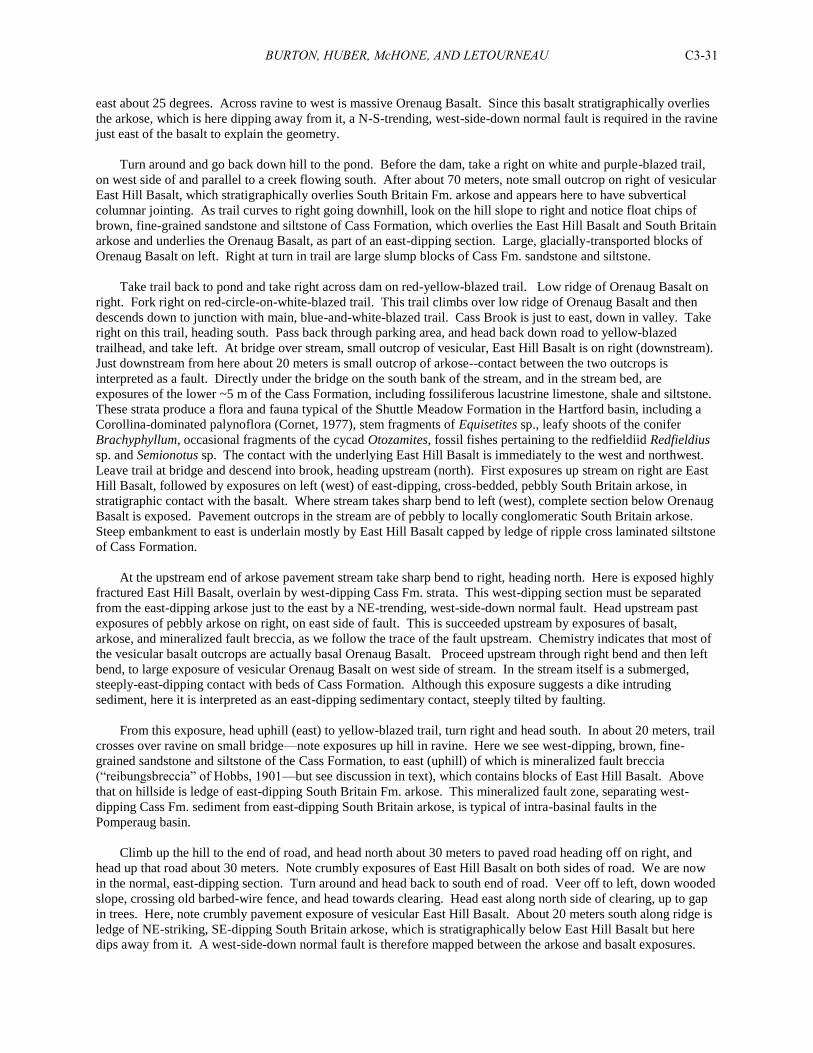
BURTON, HUBER, McHONE, AND LETOURNEAU C3-31
east about 25 degrees. Across ravine to west is massive Orenaug Basalt. Since this basalt stratigraphically overlies
the arkose, which is here dipping away from it, a N-S-trending, west-side-down normal fault is required in the ravine
just east of the basalt to explain the geometry.
Turn around and go back down hill to the pond. Before the dam, take a right on white and purple-blazed trail,
on west side of and parallel to a creek flowing south. After about 70 meters, note small outcrop on right of vesicular
East Hill Basalt, which stratigraphically overlies South Britain Fm. arkose and appears here to have subvertical
columnar jointing. As trail curves to right going downhill, look on the hill slope to right and notice float chips of
brown, fine-grained sandstone and siltstone of Cass Formation, which overlies the East Hill Basalt and South Britain
arkose and underlies the Orenaug Basalt, as part of an east-dipping section. Large, glacially-transported blocks of
Orenaug Basalt on left. Right at turn in trail are large slump blocks of Cass Fm. sandstone and siltstone.
Take trail back to pond and take right across dam on red-yellow-blazed trail. Low ridge of Orenaug Basalt on
right. Fork right on red-circle-on-white-blazed trail. This trail climbs over low ridge of Orenaug Basalt and then
descends down to junction with main, blue-and-white-blazed trail. Cass Brook is just to east, down in valley. Take
right on this trail, heading south. Pass back through parking area, and head back down road to yellow-blazed
trailhead, and take left. At bridge over stream, small outcrop of vesicular, East Hill Basalt is on right (downstream).
Just downstream from here about 20 meters is small outcrop of arkose--contact between the two outcrops is
interpreted as a fault. Directly under the bridge on the south bank of the stream, and in the stream bed, are
exposures of the lower ~5 m of the Cass Formation, including fossiliferous lacustrine limestone, shale and siltstone.
These strata produce a flora and fauna typical of the Shuttle Meadow Formation in the Hartford basin, including a
Corollina-dominated palynoflora (Cornet, 1977), stem fragments of Equisetites sp., leafy shoots of the conifer
Brachyphyllum, occasional fragments of the cycad Otozamites, fossil fishes pertaining to the redfieldiid Redfieldius
sp. and Semionotus sp. The contact with the underlying East Hill Basalt is immediately to the west and northwest.
Leave trail at bridge and descend into brook, heading upstream (north). First exposures up stream on right are East
Hill Basalt, followed by exposures on left (west) of east-dipping, cross-bedded, pebbly South Britain arkose, in
stratigraphic contact with the basalt. Where stream takes sharp bend to left (west), complete section below Orenaug
Basalt is exposed. Pavement outcrops in the stream are of pebbly to locally conglomeratic South Britain arkose.
Steep embankment to east is underlain mostly by East Hill Basalt capped by ledge of ripple cross laminated siltstone
of Cass Formation.
At the upstream end of arkose pavement stream take sharp bend to right, heading north. Here is exposed highly
fractured East Hill Basalt, overlain by west-dipping Cass Fm. strata. This west-dipping section must be separated
from the east-dipping arkose just to the east by a NE-trending, west-side-down normal fault. Head upstream past
exposures of pebbly arkose on right, on east side of fault. This is succeeded upstream by exposures of basalt,
arkose, and mineralized fault breccia, as we follow the trace of the fault upstream. Chemistry indicates that most of
the vesicular basalt outcrops are actually basal Orenaug Basalt. Proceed upstream through right bend and then left
bend, to large exposure of vesicular Orenaug Basalt on west side of stream. In the stream itself is a submerged,
steeply-east-dipping contact with beds of Cass Formation. Although this exposure suggests a dike intruding
sediment, here it is interpreted as an east-dipping sedimentary contact, steeply tilted by faulting.
From this exposure, head uphill (east) to yellow-blazed trail, turn right and head south. In about 20 meters, trail
crosses over ravine on small bridge—note exposures up hill in ravine. Here we see west-dipping, brown, fine-
grained sandstone and siltstone of the Cass Formation, to east (uphill) of which is mineralized fault breccia
(“reibungsbreccia” of Hobbs, 1901—but see discussion in text), which contains blocks of East Hill Basalt. Above
that on hillside is ledge of east-dipping South Britain Fm. arkose. This mineralized fault zone, separating west-
dipping Cass Fm. sediment from east-dipping South Britain arkose, is typical of intra-basinal faults in the
Pomperaug basin.
Climb up the hill to the end of road, and head north about 30 meters to paved road heading off on right, and
head up that road about 30 meters. Note crumbly exposures of East Hill Basalt on both sides of road. We are now
in the normal, east-dipping section. Turn around and head back to south end of road. Veer off to left, down wooded
slope, crossing old barbed-wire fence, and head towards clearing. Head east along north side of clearing, up to gap
in trees. Here, note crumbly pavement exposure of vesicular East Hill Basalt. About 20 meters south along ridge is
ledge of NE-striking, SE-dipping South Britain arkose, which is stratigraphically below East Hill Basalt but here
dips away from it. A west-side-down normal fault is therefore mapped between the arkose and basalt exposures.
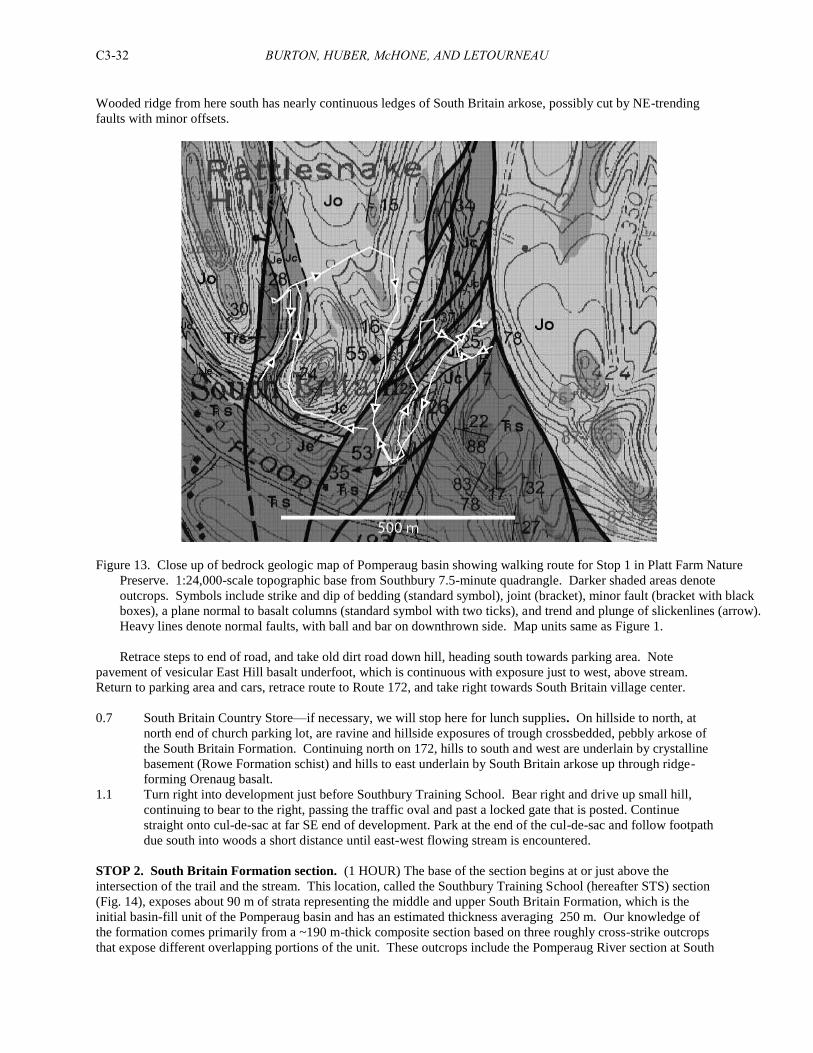
BURTON, HUBER, McHONE, AND LETOURNEAU C3-32
Wooded ridge from here south has nearly continuous ledges of South Britain arkose, possibly cut by NE-trending
faults with minor offsets.
Figure 13. Close up of bedrock geologic map of Pomperaug basin showing walking route for Stop 1 in Platt Farm Nature
Preserve. 1:24,000-scale topographic base from Southbury 7.5-minute quadrangle. Darker shaded areas denote
outcrops. Symbols include strike and dip of bedding (standard symbol), joint (bracket), minor fault (bracket with black
boxes), a plane normal to basalt columns (standard symbol with two ticks), and trend and plunge of slickenlines (arrow).
Heavy lines denote normal faults, with ball and bar on downthrown side. Map units same as Figure 1.
Retrace steps to end of road, and take old dirt road down hill, heading south towards parking area. Note
pavement of vesicular East Hill basalt underfoot, which is continuous with exposure just to west, above stream.
Return to parking area and cars, retrace route to Route 172, and take right towards South Britain village center.
0.7 South Britain Country Store—if necessary, we will stop here for lunch supplies. On hillside to north, at
north end of church parking lot, are ravine and hillside exposures of trough crossbedded, pebbly arkose of
the South Britain Formation. Continuing north on 172, hills to south and west are underlain by crystalline
basement (Rowe Formation schist) and hills to east underlain by South Britain arkose up through ridge-
forming Orenaug basalt.
1.1 Turn right into development just before Southbury Training School. Bear right and drive up small hill,
continuing to bear to the right, passing the traffic oval and past a locked gate that is posted. Continue
straight onto cul-de-sac at far SE end of development. Park at the end of the cul-de-sac and follow footpath
due south into woods a short distance until east-west flowing stream is encountered.
STOP 2. South Britain Formation section. (1 HOUR) The base of the section begins at or just above the
intersection of the trail and the stream. This location, called the Southbury Training School (hereafter STS) section
(Fig. 14), exposes about 90 m of strata representing the middle and upper South Britain Formation, which is the
initial basin-fill unit of the Pomperaug basin and has an estimated thickness averaging 250 m. Our knowledge of
the formation comes primarily from a ~190 m-thick composite section based on three roughly cross-strike outcrops
that expose different overlapping portions of the unit. These outcrops include the Pomperaug River section at South
BURTON, HUBER, McHONE, AND LETOURNEAU C3-33
Britain Village, described by Schutz (1956), Hubert et al. (1978), Weddle and Hubert (1983), and Lorenz (1987), the
O. Mitchell Brook section briefly described by Hobbs (1901), and this section (Fig. 14), which until our recent work,
had never been studied, though Hobbs (1901) makes vague reference to its location. Other, limited exposures of the
South Britain Formation are found in various areas of the basin, but typically represent several meters or more of the
uppermost Rattlesnake Conglomerate Member.
The basal ~60 m of the South Britain Formation is not exposed, and the stratigraphically-lowest outcrops of the
formation occur at the base of the Pomperaug River section. The middle and upper South Britain Formation is
composed primarily of three facies associations that maintain their sedimentological character and stratigraphic
position for at least 8 km along strike in the western area of the basin. The first facies consists of 0.5-3 m-thick beds
of medium to coarse grained, well-sorted to poorly-sorted, trough cross-bedded arkosic sandstone that is often
capped by relatively thin (0.25-2 m-thick) massive, burrowed and/or pedoturbated to ripple cross-laminated sandy
siltstone. The lower 20 m of the STS section is composed of this facies, which we interpret as deposits of sandy,
braided streams that flowed in an easterly direction from the western margin of the Pomperaug basin.
The second facies consists of thin beds (0.5-2 m-thick) of trough cross bedded, pebbly arkose that are overlain by
as much as 18 m-thick sequences of massive, burrowed and/or pedoturbated to ripple cross laminated sandy siltstone
and silty mudstone. This facies occupies a stratigraphic interval that encompasses approximately 110 m of the
middle South Britain Formation, and represents the upper 70 m of the STS section (Fig. 14). The facies association
is a classic fining-upward, fluvial point bar sequence deposited by meandering streams and rivers. Furthermore, the
facies are conformable and gradational with underlying braided stream deposits, documenting maturation of the
local drainage network as basin surface area increased over time, and possibly indicating the influence of a more
humid regional climate. A remarkable aspect of the basal lag pebble conglomerates in this sequence is the
abundance of carbonate pebbles. Some appear to be the products of reworked caliche, but others are
metamorphosed limestone (marble). As paleocurrents at most exposures of the South Britain Formation are largely
confined to a 40 degree sector (N290-330E, n = 250), it is obvious that the extra-basinal carbonate clasts were
derived from basement terrain located to the west and northwest of the basin. The only metamorphic carbonate unit
located in this region of the western uplands of Connecticut is the Stockbridge Marble, according to the Bedrock
Geological Map of Connecticut (Rodgers, 1985), the closest outcrops of which are located some 12 km west and
northwest of the basin.
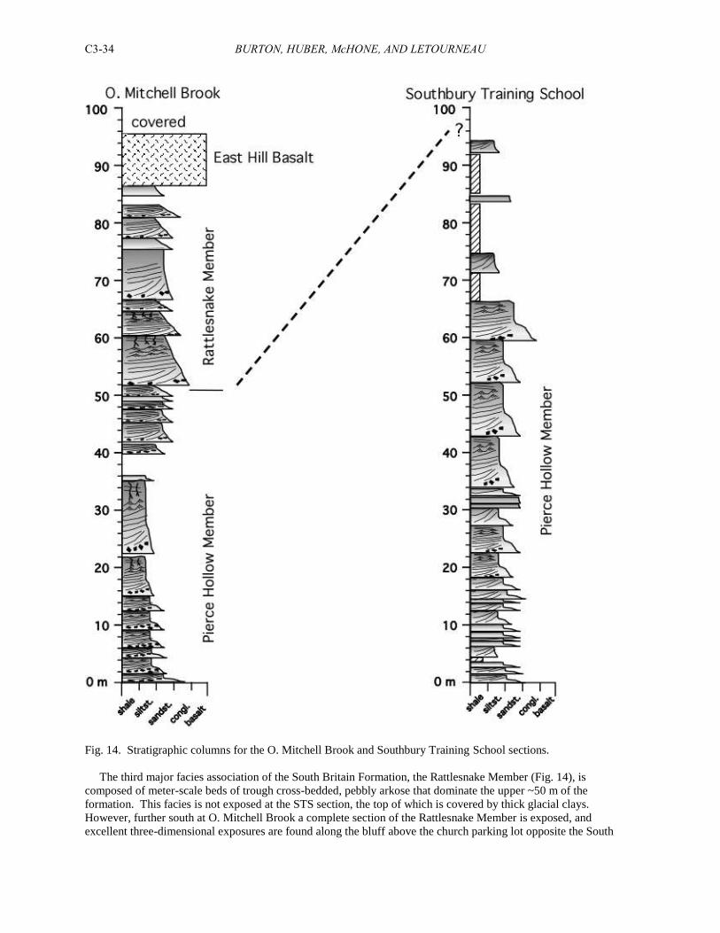
BURTON, HUBER, McHONE, AND LETOURNEAU C3-34
Fig. 14. Stratigraphic columns for the O. Mitchell Brook and Southbury Training School sections.
The third major facies association of the South Britain Formation, the Rattlesnake Member (Fig. 14), is
composed of meter-scale beds of trough cross-bedded, pebbly arkose that dominate the upper ~50 m of the
formation. This facies is not exposed at the STS section, the top of which is covered by thick glacial clays.
However, further south at O. Mitchell Brook a complete section of the Rattlesnake Member is exposed, and
excellent three-dimensional exposures are found along the bluff above the church parking lot opposite the South
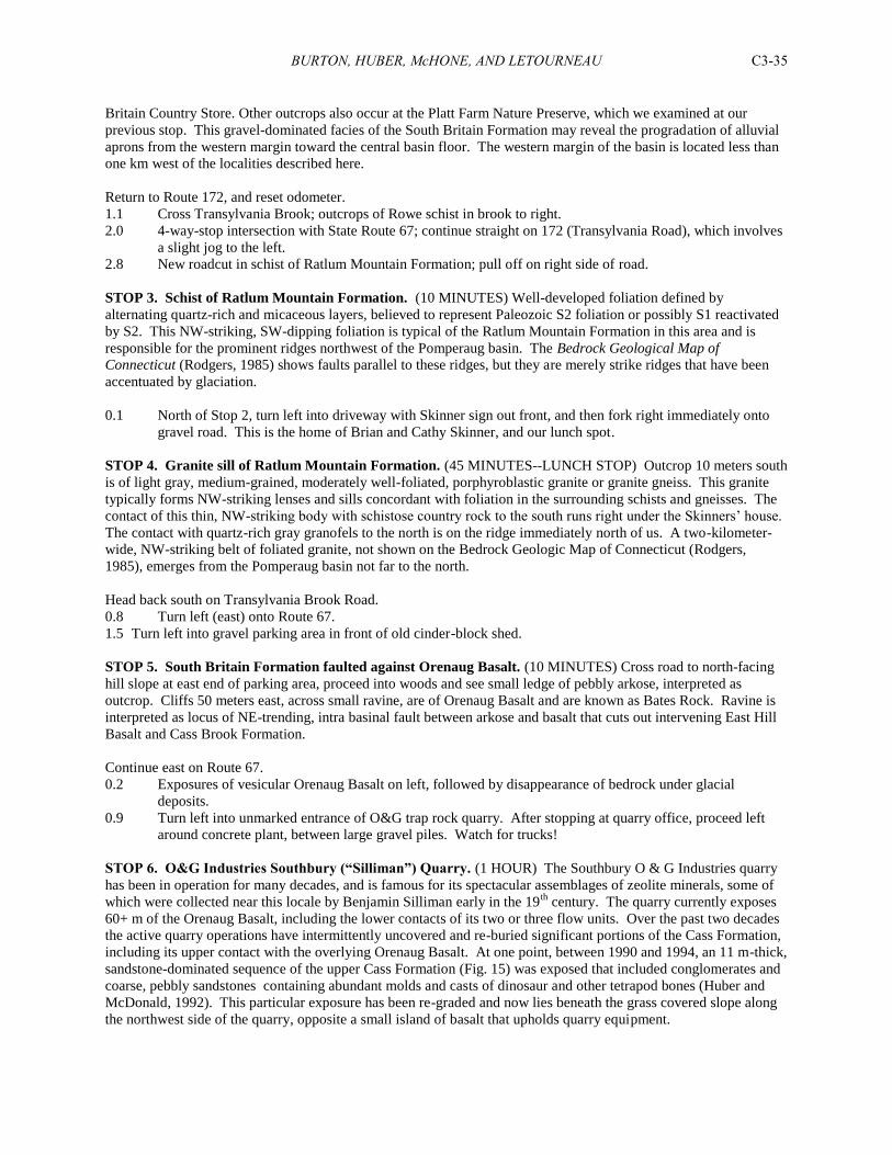
BURTON, HUBER, McHONE, AND LETOURNEAU C3-35
Britain Country Store. Other outcrops also occur at the Platt Farm Nature Preserve, which we examined at our
previous stop. This gravel-dominated facies of the South Britain Formation may reveal the progradation of alluvial
aprons from the western margin toward the central basin floor. The western margin of the basin is located less than
one km west of the localities described here.
Return to Route 172, and reset odometer.
1.1 Cross Transylvania Brook; outcrops of Rowe schist in brook to right.
2.0 4-way-stop intersection with State Route 67; continue straight on 172 (Transylvania Road), which involves
a slight jog to the left.
2.8 New roadcut in schist of Ratlum Mountain Formation; pull off on right side of road.
STOP 3. Schist of Ratlum Mountain Formation. (10 MINUTES) Well-developed foliation defined by
alternating quartz-rich and micaceous layers, believed to represent Paleozoic S2 foliation or possibly S1 reactivated
by S2. This NW-striking, SW-dipping foliation is typical of the Ratlum Mountain Formation in this area and is
responsible for the prominent ridges northwest of the Pomperaug basin. The Bedrock Geological Map of
Connecticut (Rodgers, 1985) shows faults parallel to these ridges, but they are merely strike ridges that have been
accentuated by glaciation.
0.1 North of Stop 2, turn left into driveway with Skinner sign out front, and then fork right immediately onto
gravel road. This is the home of Brian and Cathy Skinner, and our lunch spot.
STOP 4. Granite sill of Ratlum Mountain Formation. (45 MINUTES--LUNCH STOP) Outcrop 10 meters south
is of light gray, medium-grained, moderately well-foliated, porphyroblastic granite or granite gneiss. This granite
typically forms NW-striking lenses and sills concordant with foliation in the surrounding schists and gneisses. The
contact of this thin, NW-striking body with schistose country rock to the south runs right under the Skinners’ house.
The contact with quartz-rich gray granofels to the north is on the ridge immediately north of us. A two-kilometer-
wide, NW-striking belt of foliated granite, not shown on the Bedrock Geologic Map of Connecticut (Rodgers,
1985), emerges from the Pomperaug basin not far to the north.
Head back south on Transylvania Brook Road.
0.8 Turn left (east) onto Route 67.
1.5 Turn left into gravel parking area in front of old cinder-block shed.
STOP 5. South Britain Formation faulted against Orenaug Basalt. (10 MINUTES) Cross road to north-facing
hill slope at east end of parking area, proceed into woods and see small ledge of pebbly arkose, interpreted as
outcrop. Cliffs 50 meters east, across small ravine, are of Orenaug Basalt and are known as Bates Rock. Ravine is
interpreted as locus of NE-trending, intra basinal fault between arkose and basalt that cuts out intervening East Hill
Basalt and Cass Brook Formation.
Continue east on Route 67.
0.2 Exposures of vesicular Orenaug Basalt on left, followed by disappearance of bedrock under glacial
deposits.
0.9 Turn left into unmarked entrance of O&G trap rock quarry. After stopping at quarry office, proceed left
around concrete plant, between large gravel piles. Watch for trucks!
STOP 6. O&G Industries Southbury (“Silliman”) Quarry. (1 HOUR) The Southbury O & G Industries quarry
has been in operation for many decades, and is famous for its spectacular assemblages of zeolite minerals, some of
which were collected near this locale by Benjamin Silliman early in the 19th
century. The quarry currently exposes
60+ m of the Orenaug Basalt, including the lower contacts of its two or three flow units. Over the past two decades
the active quarry operations have intermittently uncovered and re-buried significant portions of the Cass Formation,
including its upper contact with the overlying Orenaug Basalt. At one point, between 1990 and 1994, an 11 m-thick,
sandstone-dominated sequence of the upper Cass Formation (Fig. 15) was exposed that included conglomerates and
coarse, pebbly sandstones containing abundant molds and casts of dinosaur and other tetrapod bones (Huber and
McDonald, 1992). This particular exposure has been re-graded and now lies beneath the grass covered slope along
the northwest side of the quarry, opposite a small island of basalt that upholds quarry equipment.
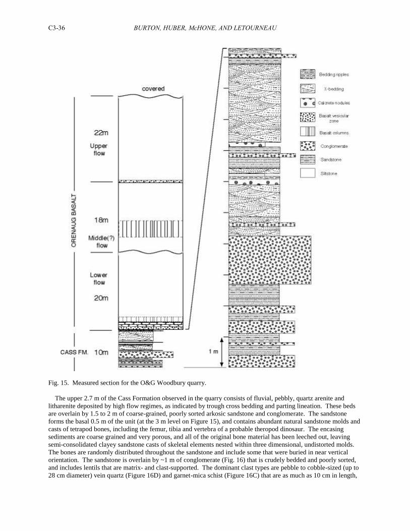
BURTON, HUBER, McHONE, AND LETOURNEAU C3-36
Fig. 15. Measured section for the O&G Woodbury quarry.
The upper 2.7 m of the Cass Formation observed in the quarry consists of fluvial, pebbly, quartz arenite and
litharenite deposited by high flow regimes, as indicated by trough cross bedding and parting lineation. These beds
are overlain by 1.5 to 2 m of coarse-grained, poorly sorted arkosic sandstone and conglomerate. The sandstone
forms the basal 0.5 m of the unit (at the 3 m level on Figure 15), and contains abundant natural sandstone molds and
casts of tetrapod bones, including the femur, tibia and vertebra of a probable theropod dinosaur. The encasing
sediments are coarse grained and very porous, and all of the original bone material has been leeched out, leaving
semi-consolidated clayey sandstone casts of skeletal elements nested within three dimensional, undistorted molds.
The bones are randomly distributed throughout the sandstone and include some that were buried in near vertical
orientation. The sandstone is overlain by ~1 m of conglomerate (Fig. 16) that is crudely bedded and poorly sorted,
and includes lentils that are matrix- and clast-supported. The dominant clast types are pebble to cobble-sized (up to
28 cm diameter) vein quartz (Figure 16D) and garnet-mica schist (Figure 16C) that are as much as 10 cm in length,
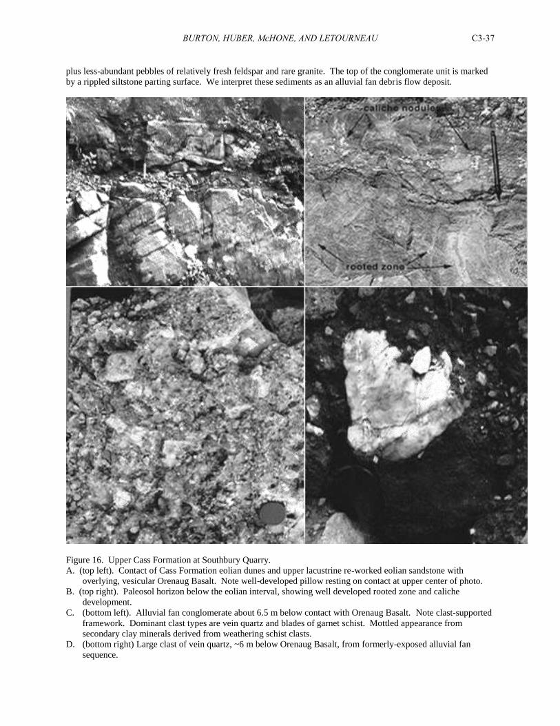
BURTON, HUBER, McHONE, AND LETOURNEAU C3-37
plus less-abundant pebbles of relatively fresh feldspar and rare granite. The top of the conglomerate unit is marked
by a rippled siltstone parting surface. We interpret these sediments as an alluvial fan debris flow deposit.
Figure 16. Upper Cass Formation at Southbury Quarry.
A. (top left). Contact of Cass Formation eolian dunes and upper lacustrine re-worked eolian sandstone with
overlying, vesicular Orenaug Basalt. Note well-developed pillow resting on contact at upper center of photo.
B. (top right). Paleosol horizon below the eolian interval, showing well developed rooted zone and caliche
development.
C. (bottom left). Alluvial fan conglomerate about 6.5 m below contact with Orenaug Basalt. Note clast-supported
framework. Dominant clast types are vein quartz and blades of garnet schist. Mottled appearance from
secondary clay minerals derived from weathering schist clasts.
D. (bottom right) Large clast of vein quartz, ~6 m below Orenaug Basalt, from formerly-exposed alluvial fan
sequence.
BURTON, HUBER, McHONE, AND LETOURNEAU C3-38
The arkosic debris flow deposit is sharply overlain by 1.5 m of trough and planar cross bedded, fine-grained,
subarkose that contains a prominent, 4 cm-thick conglomerate zone near the base that is composed of flat, ellipsoid
siltstone intraclasts (up to 5 cm in length) and a lesser percentage of extrabasinal pebbles. Above this unit is a 0.6
m-thick, trough cross bedded, subarkosic/sublithic arenite that contains abundant, grayish green (5G 5/2) nodules of
pedogenic carbonate. The middle of the unit is punctuated by a prominent siltstone parting surface that displays
asymmetric ripple marks spaced 25 cm apart, crest to crest (at the 6.2 m level on Figure 3).
The following 0.8 m of strata consist of siltstone and arkosic sandstone and conglomerate. The base of the unit is
a mud cracked, siltstone parting surface that contains abundant, though poorly preserved, reptile trackways referable
to the ichnogenera Batrachopus sp., Grallator sp., and Eubrontes sp., as well as meter length casts and impressions
of equisetalians and small leafy shoots of conifer foliage (cf. Brachyphyllum sp.). Above the parting surface,
sandstone coarsens upward into a 12 cm thick zone of pebble conglomerate that contains abundant, angular pebbles
and small cobbles of metamorphic carbonate, which we believe were derived from the Stockbridge Marble (at 6.8 m
level on Figure 3). The top 10 cm of the unit are composed of fine grained sandstone and sandy siltstone that are
mottled grayish green, and contain spectacular rhizoconcretions and caliche nodules indicative of semi-arid
depositional conditions on the former floodplain (Figure 16B). The caliche paleosol horizon is, in turn, overlain by
a noteworthy 2 to 3 m thick layer of trough cross bedded, eolian quartz sandstone (Figure 16A) that is capped by a
thin interval of ripple-laminated, pebbly, reworked eolian sandstone and occurs just below the undulating, pillowed
contact with the Orenaug Basalt (LeTourneau and Huber, 1997 and in review).
Significance of the eolian sandstone. While common in the Fundy Basin, eolian sandstones have been regarded as
notably scarce or absent in the Hartford-Deerfield and Newark basins. Smoot (1991) identified a thin, meter-scale
eolian sandsheet in the upper New Haven Formation of the Hartford basin, and the ongoing work of Letourneau
(2002) in the Hartford basin has revealed significant eolian sandstones in the lower Jurassic
Portland Formation at the Portland, Connecticut brownstone quarry and in the upper New Haven Formation
/lower Shuttle Meadow Formation at Newgate Prison State Park in Granby, Connecticut. Identification of eolian
sandstone is important for reconstructing early Mesozoic paleoclimate. Recognition of the eolian sandstone is based
on comparison of sedimentary structures and bedding features (Figure 17A-C) with analogs from both modern
environments and ancient dune deposits. Important criteria that indicate an eolian origin for this sandstone at Stop 7
include:
1) inverse grading of thin beds and laminae comparable to pinstripe lamination
(Fryberger and Schenk, 1988), and subcritically climbing translatent strata (Hunter,
1977; Kocurek and Dott, 1981);
2) sandflow cross strata and grainfall laminae (e. g. Hunter, 1977; Schenk, 1990);
3) high-index ripples with coarser grains near the ripple crests (e. g. Fryberger et al.,
1979; Fryberger and Schenk, 1988);
4) tabular, wedge-shaped planar and trough cross-stratification with high- to low-angle
laminae (e. g. McKee and Weir, 1953; Kocurek and Dott (1981); and
5) High sorting, high porosity and high permeability (Ahlbrandt, 1979).
A remarkable aspect of the Pomperaug basin eolian sandsheet is its small thickness relative to its wide aerial
distribution. The eolian sandstone is traceable from Platt Farm Park to the Southbury Quarry north and east to the
Woodbury Quarry (Stops 7 and 8), a distance of about 12 km, indicating that the eolian dune field was widespread
across the basin, and not a local feature. Thin, but widespread dune fields are observed in many of the modern
valleys of the Basin and Range Province of the western U.S. In particular, the Stovepipes Wells dune field of Death
Valley and the dune fields of the Panamint Valley bear a striking resemblance to the Pomperaug basin dune field.
BURTON, HUBER, McHONE, AND LETOURNEAU C3-39
Figure 17. Eolian sandstone of the upper Cass Formation.
A) Block of sandstone from the O&G Southbury quarry showing eolian sedimentary structures including
toesets of small dunes. Coarse normal to reverse graded grain-flow (gfl) wedges are interbedded with
massive to laminated grain-fall (gfa) wedges. Grain-flow (gfl) layers are formed by small avalanches of
sand on the lee-side dune face; grain-fall (gfa) layers are formed by wind-blown sand streaming across the
dune brink-point and settling on the lee-side foresets. Inverse-graded pinstripe laminations and subcritically
climbing translatent strata are formed by migrating ripples. Porosity of this unit is high…..
B) Block of sandstone from the O&G Southbury quarry showing inverse-graded wind-ripple laminae, low-
angle foresets, and isolated high-index ripples typical of modern and ancient eolian deposits.
C) Block of sandstone from the O&G Southbury quarry showing grain-flow (gfl) and grain-fall (gfa) dune
toesets. The occurrence of these distinctive features is diagnostic of eolian deposits.
Laboratory measurements of samples of the Pomperaug eolian sandstone revealed porosities ranging from 15 to
20 %. Gas permeability reached values as high as 395 millidarcies (mD) and liquid (Klinkenberg) permeability up to
368 mD. The relatively high porosity and permeability values support the high sorting and grain support framework
observed in hand samples. The porosity and permeabilities of the eolian beds indicate that the horizon may be a
significant aquifer or pathway for contaminated groundwater. Furthermore, due to its location directly beneath the
Orenaug Basalt it has a significant potential to be a semi-confined, artesian aquifer, similar to an artesian occurrence
in the Hartford basin (observed in the field by LeTourneau).
BURTON, HUBER, McHONE, AND LETOURNEAU C3-40
Reset odometer at quarry entrance, and turn left onto Route 67, heading east.
0.1 Cross Pomperaug River.
0.3 Turn left onto Route 6 East.
2.6 Intersection with Route 64 East (Sherman Hill Road). Continue straight, entering village of Woodbury.
3.1 Take right onto Orenaug Avenue, at south end of village center. Pass over ridge of Orenaug Basalt, then
pass Orenaug Park on left.
3.5 Unmarked entrance on left to O&G Woodbury trap rock quarry. Proceed slowly into quarry, keeping
an eye out for trucks.
STOP 7. Fault-offset Cass Formation in O&G Woodbury Trap Rock Quarry. (45 MINUTES) This quarry
exposes a contact between eolian sandstone of the Cass Formation and overlying Orenaug Basalt that has been offset
along a N-S-trending, high-angle normal fault, which until recently was perfectly exposed along the west quarry
wall. Our first stop in the quarry is at a small pavement of the sandstone atop the west quarry wall, which marks the
western, upthrown side of the east-side-down fault. The color of the sandstone -- normally white, but here an orange
hue--is due to thermal alteration produced during the flow of lava over this sediment. Walk carefully over to the
linear pile of rubble that marks the quarry wall edge, and look towards the north end of the quarry. Visible at the
bottom of the quarry near the north end is another, larger sandstone pavement, marking the same horizon but
displaced downward some 30 meters and rotated into a more easterly strike. The fault, which runs north-south
virtually under our feet at this spot, is marked by a one to two-meter-wide, planar zone of extensive brecciation and
mineralization, and secondary growth of quartz, calcite, stilbite, and other minerals, as well as bitumen. Outcrop-
scale slickenlines on the mineralized fault surface plunge about 25 degrees north (Fig. 15), indicating that there was
a left-lateral strike-slip component to the fault movement, as discussed in the main text.
Figure 18. Mineralized fault zone exposed in west wall of O&G Woodbury quarry that offsets bedding pavement of
Cass Formation. Note slickenlines dipping moderately to the right (north), indicating strike-slip component to
down-to-the-east movement sense.
Driving down into the central part of the quarry, we pass the wall to our left that contains the fault exposure,
now covered in rubble, and head north to the large sandstone pavement. This pavement was also better exposed
previously, but most of the salient features are still visible underneath the gravel. These include ripple marks that
BURTON, HUBER, McHONE, AND LETOURNEAU C3-41
indicate a NE-SW current direction, bowl-shaped impressions left by lava pillows that formed as the lava flowed
over wet sediment, and small offsets in the bedding surface caused by minor, mineralized normal faults. This
sandstone likewise shows discoloration due to thermal alteration by the overlying lava, which is still preserved as
small patches of a dark contact rind, particularly in the bottoms of the pillow impressions.
Proceed back out the quarry, and from quarry entrance turn left on Orenaug Avenue.
0.1 At stop sign, take left onto Bacon Pond Road.
0.2 Turn left into unmarked eastern entrance of quarry, proceed to end of drive marked by large boulders.
STOP 8. Contact Between Orenaug Basalt and Cass Brook Formation. (10 MINUTES) This ledge exposes
Orenaug Basalt in contact with underlying fine-grained sandstone of Cass Brook Formation, the latter which is
brownish-weathering, greenish-gray fresh, medium to fine-grained, locally pebbly sandstone, similar to sedimentary
rock exposed in quarry. Here sandstone and basalt/sandstone contact are gently west-dipping and help to define east
limb of Woodbury hanging-wall syncline (Fig. 1). Note N-S trending, steeply east-dipping curviplanar fault surface
in sandstone with subhorizontal slickenlines. NNE-trending eastern border fault of basin passes along road or edge
of woods just to the east. Hills beyond are underlain by schist of Taine Mountain and basal Taine Mountain
formations (Ot and Otb, respectively, Fig. 1).
Turn around and turn right on Bacon Pond Road, heading south.
0.3 Continue straight through four-way intersection.
0.6 Continue straight through after stop sign, curving left.
0.7 Intersection with Old Sherman Hill Road (Route 64). Proceed through intersection and take right fork onto
Middle Quarter Road.
1.0 Stop sign and one-lane bridge over South Brook. Cross bridge and pull over on the left into gravel parking
area. Walk back over bridge and take right up gated gravel road on north side of South Brook. The road
follows the bed of an old trolley that once ran between Woodbury and Waterbury. About 100 meters up
road to the right (south) is flush-mounted USGS monitoring well CT-WY-87. Core extracted during the
drilling of this well is of massive fine-grained basalt, which geochemical analysis shows to be Orenaug
Basalt.
STOP 9. Contact Between White Oaks Formation and South Brook Basalt. (1 HOUR) Small exposures in E-
W reach of stream are of blocky, fractured, gently E-dipping pebbly sandstone in contact with overlying vesicular
basalt. Just upstream begins continuous exposure of this basalt. Because of its vesicular texture, the basalt
superficially resembles East Hill Basalt and was originally mapped as such, since the exposed section here is
roughly equivalent in thickness. However, geochemical analysis of a sample from this exposed contact in the
stream, plus a more altered sample from upstream near the border fault, shows it to be chemically distinct from
either Orenaug or East Hill basalts (Fig. 10). We therefore feel justified in calling this the “third basalt”, in
agreement with the interpretation on the Bedrock Geological Map of Connecticut (Rodgers, 1985), and have named
it the South Brook Basalt (Fig. 1). The underlying sedimentary rock is named the White Oaks Formation, after a
crossroads halfway between Woodbury and Southbury. The only other known exposure of this rock, now gone, was
reported by Hobbs (1901) adjacent to an oil well drilled near the village of Southbury, about five kilometers to the
south, although its existence is also suggested in well logs from the White Oaks area (Fig. 1), and blocks of black
shale of probable White Oak affinity were recovered from a gravel quarry in Southbury (Fig. 19).
Proceeding farther upstream along road is another USGS monitoring well, CT-WY-86, on the left (northeast)
side of the road where it bends to the south, following the brook. This well cored pegmatite and schist at about 20
feet, representative of the footwall of the eastern border fault. Fine-grained mica schist of the Taine Mountain
Formation (Ot, Fig. 1) is also exposed in a small outcrop just south along the east side of the road. Scramble down
hill towards brook, where along this N-S reach of the brook are more outcrops of vesicular basalt. This rock is
brecciated and highly altered due to its very close proximity to the eastern border fault, which parallels and probably
underlies the brook. The basalt contains abundant secondary interstitial silica, chlorite and calcite, as well as two
copper prospects, one visible here near north end of ridge and one about 100 meters south. Exposed at one spot
along this stretch of outcrops, between the two copper prospects, is a gently-west-dipping contact between South
BURTON, HUBER, McHONE, AND LETOURNEAU C3-42
Brook Basalt and underlying White Oaks conglomerate. This is the eastern limb of the South Brook hanging-wall
syncline, comprising the two formations, which has been extrapolated southward based on well records (Fig. 1).
Fig. 19. Block of black shale (White Oak Fm.?) recovered from a quarry in Southbury
Clasts in the conglomerate include rounded pebbles of quartz, plus elongate chips of garnet mica schist and
siltstone that suggest a proximal source. The elongate schist fragments likely represent material shed off the scarp
of the eastern border fault, just to the east. The fault crosses underneath the brook and intersects the ridge towards
the south, where fine-grained mica schist of the footwall is exposed.
End of Trip
To return to original meeting area, go south on Middle Quarter Rd. to intersection with Route 6, just ahead, and
take left on Route 6. Proceed 3.1 miles south on Route 6 to Southbury village center, take right at second light on
Main Street South, opposite Southbury Plaza, go 1.8 miles west to intersection with Route 172; park and ride is on
the left just before intersection.
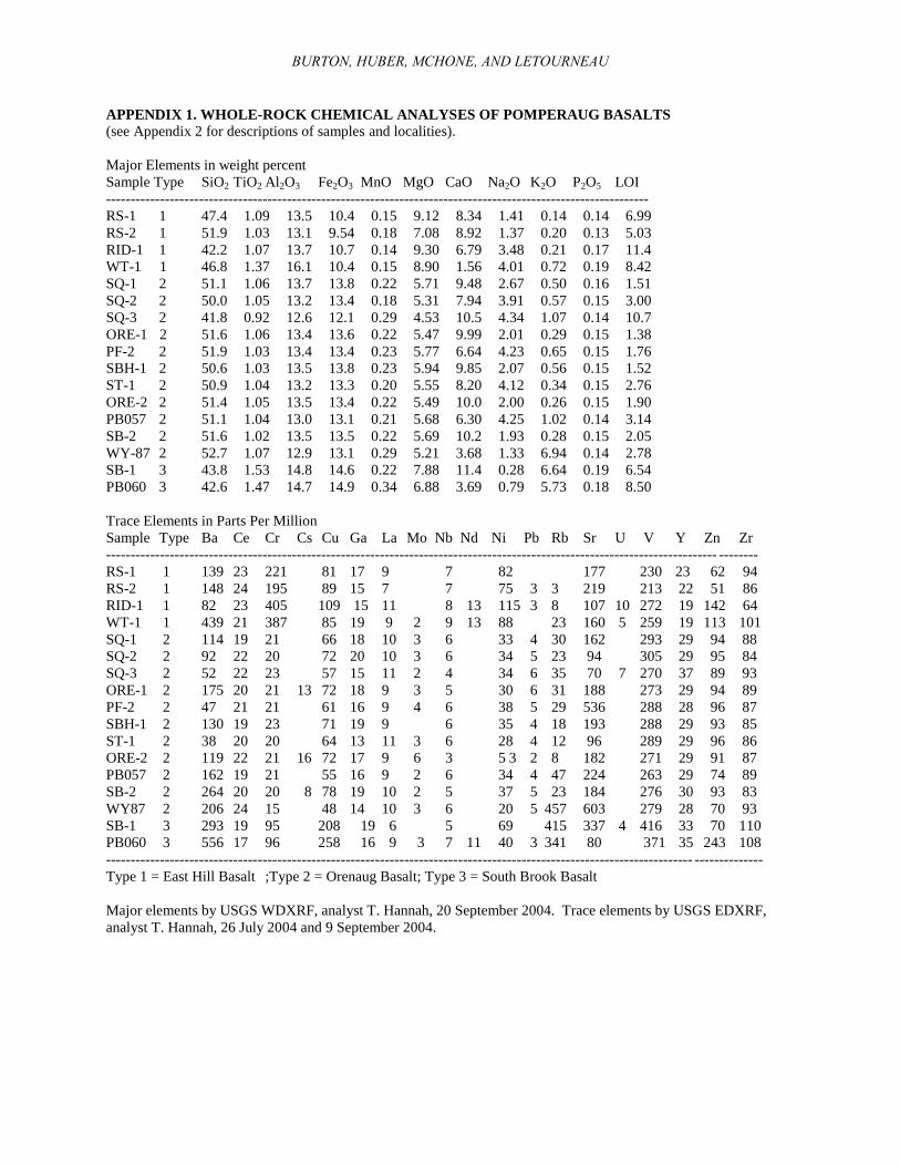
BURTON, HUBER, MCHONE, AND LETOURNEAU
APPENDIX 1. WHOLE-ROCK CHEMICAL ANALYSES OF POMPERAUG BASALTS
(see Appendix 2 for descriptions of samples and localities).
Major Elements in weight percent
Sample Type SiO2 TiO2 Al2O3 Fe2O3 MnO MgO CaO Na2O K2O P2O5 LOI
---------------------------------------------------------------------------------------------------------------
RS-1 1 47.4 1.09 13.5 10.4 0.15 9.12 8.34 1.41 0.14 0.14 6.99
RS-2 1 51.9 1.03 13.1 9.54 0.18 7.08 8.92 1.37 0.20 0.13 5.03
RID-1 1 42.2 1.07 13.7 10.7 0.14 9.30 6.79 3.48 0.21 0.17 11.4
WT-1 1 46.8 1.37 16.1 10.4 0.15 8.90 1.56 4.01 0.72 0.19 8.42
SQ-1 2 51.1 1.06 13.7 13.8 0.22 5.71 9.48 2.67 0.50 0.16 1.51
SQ-2 2 50.0 1.05 13.2 13.4 0.18 5.31 7.94 3.91 0.57 0.15 3.00
SQ-3 2 41.8 0.92 12.6 12.1 0.29 4.53 10.5 4.34 1.07 0.14 10.7
ORE-1 2 51.6 1.06 13.4 13.6 0.22 5.47 9.99 2.01 0.29 0.15 1.38
PF-2 2 51.9 1.03 13.4 13.4 0.23 5.77 6.64 4.23 0.65 0.15 1.76
SBH-1 2 50.6 1.03 13.5 13.8 0.23 5.94 9.85 2.07 0.56 0.15 1.52
ST-1 2 50.9 1.04 13.2 13.3 0.20 5.55 8.20 4.12 0.34 0.15 2.76
ORE-2 2 51.4 1.05 13.5 13.4 0.22 5.49 10.0 2.00 0.26 0.15 1.90
PB057 2 51.1 1.04 13.0 13.1 0.21 5.68 6.30 4.25 1.02 0.14 3.14
SB-2 2 51.6 1.02 13.5 13.5 0.22 5.69 10.2 1.93 0.28 0.15 2.05
WY-87 2 52.7 1.07 12.9 13.1 0.29 5.21 3.68 1.33 6.94 0.14 2.78
SB-1 3 43.8 1.53 14.8 14.6 0.22 7.88 11.4 0.28 6.64 0.19 6.54
PB060 3 42.6 1.47 14.7 14.9 0.34 6.88 3.69 0.79 5.73 0.18 8.50
Trace Elements in Parts Per Million
Sample Type Ba Ce Cr Cs Cu Ga La Mo Nb Nd Ni Pb Rb Sr U V Y Zn Zr
----------------------------------------------------------------------------------------------------------------------------- --------
RS-1 1 139 23 221 81 17 9 7 82 177 230 23 62 94
RS-2 1 148 24 195 89 15 7 7 75 3 3 219 213 22 51 86
RID-1 1 82 23 405 109 15 11 8 13 115 3 8 107 10 272 19 142 64
WT-1 1 439 21 387 85 19 9 2 9 13 88 23 160 5 259 19 113 101
SQ-1 2 114 19 21 66 18 10 3 6 33 4 30 162 293 29 94 88
SQ-2 2 92 22 20 72 20 10 3 6 34 5 23 94 305 29 95 84
SQ-3 2 52 22 23 57 15 11 2 4 34 6 35 70 7 270 37 89 93
ORE-1 2 175 20 21 13 72 18 9 3 5 30 6 31 188 273 29 94 89
PF-2 2 47 21 21 61 16 9 4 6 38 5 29 536 288 28 96 87
SBH-1 2 130 19 23 71 19 9 6 35 4 18 193 288 29 93 85
ST-1 2 38 20 20 64 13 11 3 6 28 4 12 96 289 29 96 86
ORE-2 2 119 22 21 16 72 17 9 6 3 5 3 2 8 182 271 29 91 87
PB057 2 162 19 21 55 16 9 2 6 34 4 47 224 263 29 74 89
SB-2 2 264 20 20 8 78 19 10 2 5 37 5 23 184 276 30 93 83
WY87 2 206 24 15 48 14 10 3 6 20 5 457 603 279 28 70 93
SB-1 3 293 19 95 208 19 6 5 69 415 337 4 416 33 70 110
PB060 3 556 17 96 258 16 9 3 7 11 40 3 341 80 371 35 243 108
------------------------------------------------------------------------------------------------------------------------ --------------
Type 1 = East Hill Basalt ;Type 2 = Orenaug Basalt; Type 3 = South Brook Basalt
Major elements by USGS WDXRF, analyst T. Hannah, 20 September 2004. Trace elements by USGS EDXRF,
analyst T. Hannah, 26 July 2004 and 9 September 2004.
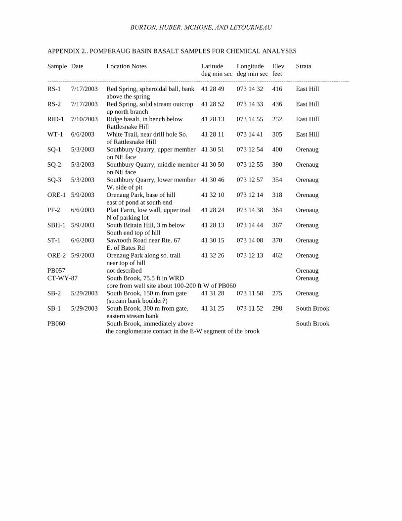
BURTON, HUBER, MCHONE, AND LETOURNEAU
APPENDIX 2.. POMPERAUG BASIN BASALT SAMPLES FOR CHEMICAL ANALYSES
Sample Date Location Notes Latitude Longitude Elev. Strata
deg min sec deg min sec feet
------------------------------------------------------------------------------------------------------------------------------------------
RS-1 7/17/2003 Red Spring, spheroidal ball, bank 41 28 49 073 14 32 416 East Hill
above the spring
RS-2 7/17/2003 Red Spring, solid stream outcrop 41 28 52 073 14 33 436 East Hill
up north branch
RID-1 7/10/2003 Ridge basalt, in bench below 41 28 13 073 14 55 252 East Hill
Rattlesnake Hill
WT-1 6/6/2003 White Trail, near drill hole So. 41 28 11 073 14 41 305 East Hill
of Rattlesnake Hill
SQ-1 5/3/2003 Southbury Quarry, upper member 41 30 51 073 12 54 400 Orenaug
on NE face
SQ-2 5/3/2003 Southbury Quarry, middle member 41 30 50 073 12 55 390 Orenaug
on NE face
SQ-3 5/3/2003 Southbury Quarry, lower member 41 30 46 073 12 57 354 Orenaug
W. side of pit
ORE-1 5/9/2003 Orenaug Park, base of hill 41 32 10 073 12 14 318 Orenaug
east of pond at south end
PF-2 6/6/2003 Platt Farm, low wall, upper trail 41 28 24 073 14 38 364 Orenaug
N of parking lot
SBH-1 5/9/2003 South Britain Hill, 3 m below 41 28 13 073 14 44 367 Orenaug
South end top of hill
ST-1 6/6/2003 Sawtooth Road near Rte. 67 41 30 15 073 14 08 370 Orenaug
E. of Bates Rd
ORE-2 5/9/2003 Orenaug Park along so. trail 41 32 26 073 12 13 462 Orenaug
near top of hill
PB057 not described Orenaug
CT-WY-87 South Brook, 75.5 ft in WRD Orenaug
core from well site about 100-200 ft W of PB060
SB-2 5/29/2003 South Brook, 150 m from gate 41 31 28 073 11 58 275 Orenaug
(stream bank boulder?)
SB-1 5/29/2003 South Brook, 300 m from gate, 41 31 25 073 11 52 298 South Brook
eastern stream bank
PB060 South Brook, immediately above South Brook
the conglomerate contact in the E-W segment of the brook