Embed Size (px)
Citation preview

A Newsletter from the Federal Highway Administration (FHWA) www.gis.fhwa.dot.gov
A Look at NDOR’s Right of Way Geospatial Application This month’s Q&A is with Rose Braun,
Geographic Information Systems (GIS)
Manager at the Nebraska Department
of Roads (NDOR). She discusses NDOR’s
Right of Way (ROW) GIS-based
application.
Q. What transportation needs existed at NDOR and how did use of GIS help address these needs? A. NDOR district highway construction technical personnel needed to know in an easy-to-use, electronic format how much ROW is owned by the state for ROW staking purposes.
ROW project information prior to 1995 is documented on paper. Sell back information has always been on paper and staking reports are generated by request in the central headquarters office.
Several ROW designers were trained to use Intergraph’s GeoMedia software to enter ROW data and display the information via the Department’s web portal, the Nebraska Enterprise Centerline Transportation Attribute Resource (NECTAR).
NECTAR is NDOR’s web application tool to view various types of data and is maintained using GeoMedia WebMap. All NDOR employees have access to this tool to view construction projects, survey
Winter2010 2
Upcoming
Events
3
Editorial
from Kevin
Hunt,
NYSDOT
5
Recent
Reports
data, crash data, bridge and railroad crossing locations, aerial photography, and more. Q. Why was NECTAR chosen as a tool to compile GIS-based ROW data? A. NECTAR was chosen because it is already widely used throughout NDOR and can be accessed via staff desktops. The need for user training is minimal. Also, Intergraph’s GeoMedia software is the main analysis tool for NDOR’s GIS unit.
Screenshot of the demonstration ROW GIS layer in NECTAR.
Q. How was the ROW project initiated and how is it maintained? A. A team comprised of 11 ROW, district, and business technology GIS personnel was created in January 2008. The team conducted a pilot project to determine what ROW information should be shown in NECTAR and how information should be displayed.
U.S. Department Of Transportation Federal Highway Administration
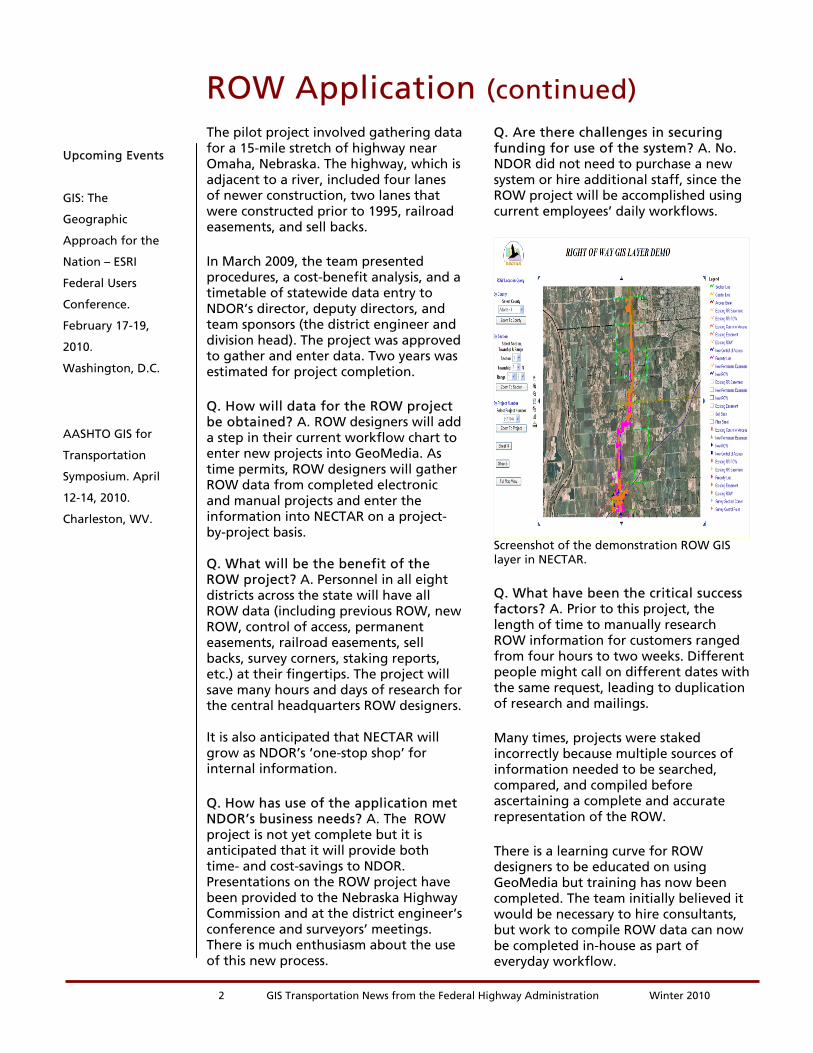
The pilot project involved gathering data for a 15-mile stretch of highway near Omaha, Nebraska. The highway, which is adjacent to a river, included four lanes of newer construction, two lanes that were constructed prior to 1995, railroad easements, and sell backs.
In March 2009, the team presented procedures, a cost-benefit analysis, and a timetable of statewide data entry to NDOR’s director, deputy directors, and team sponsors (the district engineer and division head). The project was approved to gather and enter data. Two years was estimated for project completion.
Q. How will data for the ROW project be obtained? A. ROW designers will add a step in their current workflow chart to enter new projects into GeoMedia. As time permits, ROW designers will gather ROW data from completed electronic and manual projects and enter the information into NECTAR on a project-by-project basis. Q. What will be the benefit of the ROW project? A. Personnel in all eight districts across the state will have all ROW data (including previous ROW, new ROW, control of access, permanent easements, railroad easements, sell backs, survey corners, staking reports, etc.) at their fingertips. The project will save many hours and days of research for the central headquarters ROW designers. It is also anticipated that NECTAR will grow as NDOR’s ‘one-stop shop’ for internal information.
Q. How has use of the application met NDOR’s business needs? A. The ROW project is not yet complete but it is anticipated that it will provide both time- and cost-savings to NDOR. Presentations on the ROW project have been provided to the Nebraska Highway Commission and at the district engineer’s conference and surveyors’ meetings. There is much enthusiasm about the use of this new process.
ROW Application (continued) Q. Are there challenges in securing funding for use of the system? A. No. NDOR did not need to purchase a new system or hire additional staff, since the ROW project will be accomplished using current employees’ daily workflows.
Screenshot of the demonstration ROW GIS layer in NECTAR.
Q. What have been the critical success factors? A. Prior to this project, the length of time to manually research ROW information for customers ranged from four hours to two weeks. Different people might call on different dates with the same request, leading to duplication of research and mailings.
Many times, projects were staked incorrectly because multiple sources of information needed to be searched, compared, and compiled before ascertaining a complete and accurate representation of the ROW.
There is a learning curve for ROW designers to be educated on using GeoMedia but training has now been completed. The team initially believed it would be necessary to hire consultants, but work to compile ROW data can now be completed in-house as part of everyday workflow.
2 GIS Transportation News from the Federal Highway Administration Winter 2010
Upcoming Events
GIS: The
Geographic
Approach for the
Nation – ESRI
Federal Users
Conference.
February 17-19,
2010.
Washington, D.C.
AASHTO GIS for
Transportation
Symposium. April
12-14, 2010.
Charleston, WV.
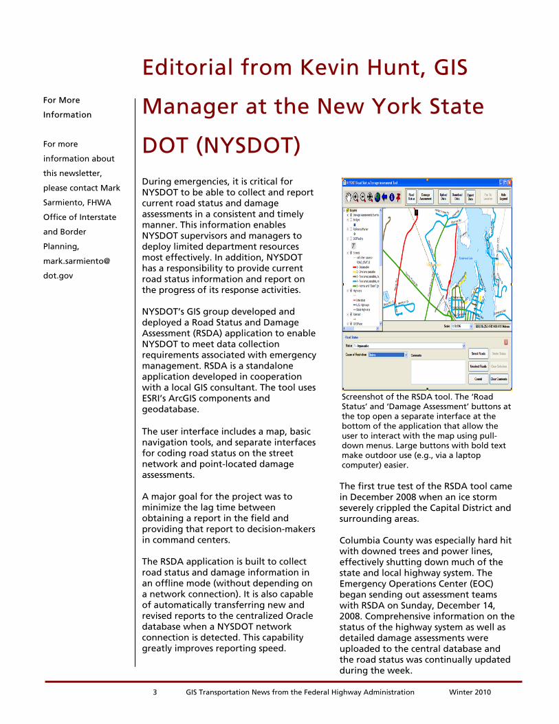
During emergencies, it is critical for NYSDOT to be able to collect and report current road status and damage assessments in a consistent and timely manner. This information enables NYSDOT supervisors and managers to deploy limited department resources most effectively. In addition, NYSDOT has a responsibility to provide current road status information and report on the progress of its response activities. NYSDOT’s GIS group developed and deployed a Road Status and Damage Assessment (RSDA) application to enable NYSDOT to meet data collection requirements associated with emergency management. RSDA is a standalone application developed in cooperation with a local GIS consultant. The tool uses ESRI’s ArcGIS components and geodatabase. The user interface includes a map, basic navigation tools, and separate interfaces for coding road status on the street network and point-located damage assessments. A major goal for the project was to minimize the lag time between obtaining a report in the field and providing that report to decision-makers in command centers. The RSDA application is built to collect road status and damage information in an offline mode (without depending on a network connection). It is also capable of automatically transferring new and revised reports to the centralized Oracle database when a NYSDOT network connection is detected. This capability greatly improves reporting speed.
Editorial from Kevin Hunt, GIS
Manager at the New York State
DOT (NYSDOT)
Screenshot of the RSDA tool. The ‘Road Status’ and ‘Damage Assessment’ buttons at the top open a separate interface at the bottom of the application that allow the user to interact with the map using pull- down menus. Large buttons with bold text make outdoor use (e.g., via a laptop computer) easier. The first true test of the RSDA tool came in December 2008 when an ice storm severely crippled the Capital District and surrounding areas. Columbia County was especially hard hit with downed trees and power lines, effectively shutting down much of the state and local highway system. The Emergency Operations Center (EOC) began sending out assessment teams with RSDA on Sunday, December 14, 2008. Comprehensive information on the status of the highway system as well as detailed damage assessments were uploaded to the central database and the road status was continually updated during the week.
3 GIS Transportation News from the Federal Highway Administration Winter 2010
For More
Information
For more
information about
this newsletter,
please contact Mark
Sarmiento, FHWA
Office of Interstate
and Border
Planning,
mark.sarmiento@
dot.gov
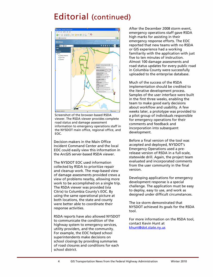
Screenshot of the browser-based RSDA viewer. The RSDA viewer provides complete road status and damage assessment information to emergency operations staff in the NYSDOT main office, regional office, and EOC. Decision-makers in the Main Office Incident Command Center and the local EOC could easily view this information in the ArcGIS server-based RSDA viewer. The NYSDOT EOC used information collected by RSDA to prioritize repair and cleanup work. The map-based view of damage assessments provided crews a view of problems nearby, allowing more work to be accomplished on a single trip. The RSDA viewer was provided (via Citrix) to Columbia County’s EOC. By using the same operational picture at both locations, the state and county were better able to coordinate their response activities. RSDA reports have also allowed NYSDOT to communicate the condition of the highway system to emergency services, utility providers, and the community. For example, the EOC helped school superintendents make decisions on school closings by providing summaries of road closures and conditions for each school district.
Editorial (continued) After the December 2008 storm event, emergency operations staff gave RSDA high marks for assisting in their emergency response efforts. The EOC reported that new teams with no RSDA or GIS experience had a working familiarity with the application with just five to ten minutes of instruction. Almost 100 damage assessments and road status updates for every public road in Columbia County were successfully uploaded to the enterprise database. Much of the success of the RSDA implementation should be credited to the iterative development process. Samples of the user interface were built in the first three weeks, enabling the team to make good early decisions about workflow and usability. A few weeks later, a prototype was provided to a pilot group of individuals responsible for emergency operations for their comments and feedback and incorporation into subsequent development. Before a final version of the tool was accepted and deployed, NYSDOT’s Emergency Operations used a pre-release version of RSDA in a full-scale, statewide drill. Again, the project team evaluated and incorporated comments from the user community in the final version. Developing applications for emergency development response is a special challenge. The application must be easy to deploy, easy to use, and work as designed under difficult circumstances. The ice storm demonstrated that NYSDOT achieved its goals for the RSDA tool. For more information on the RSDA tool, contact Kevin Hunt at [email protected]
4 GIS Transportation News from the Federal Highway Administration Winter 2010

Recent ReportsOver the last several months, FHWA has released two reports related to applications of GIS for transportation decision-making purposes. These reports, listed below, are available with along with many others at FHWA’s GIS in Transportation website: www.gis.fhwa.dot.gov
. Visit the site to learn more about these reports, as well as to submit information about your agency’s transportation GIS applications. GIS Applications for Eco-Logical Grant Projects: Peer Exchange Summary Report (July 2009) - This report provides a summary of a 1.5-day peer exchange held in Austin, TX, in July 2009. The exchange convened select recipients of FHWA's first Eco-Logical grant and allowed recipients the opportunity to share information on the GIS activities implemented with grant support. GIS Applications for Bicycle and Pedestrian Planning (May 2009) - This report provides a summary of a 1.5-day follow-up peer exchange held in Miami, FL, in May 2009. The peer exchange was sponsored by the FHWA's Office of Interstate and Border Planning.
Other News
5 GIS Transportation News from the Federal Highway Administration Winter 2010