Embed Size (px)
Citation preview
Phil Henderson, 2012 A Landscape History of Leighton Moss Nature Reserve
A Landscape History of Leighton
Moss Nature Reserve
Phil Henderson
Submitted as part of the MA Landscape Archaeology Course;
Department of Archaeology, University of York. September 2012.
(17,980 words)
Phil Henderson, 2012 A Landscape History of Leighton Moss Nature Reserve
Abstract
This work examines the history of Leighton Moss Nature Reserve, north-west
Lancashire. It looks specifically at how land-form has changed over time, and
what the impacts of changes have been on wildlife, specifically avifauna. It
relates well to the academic field of historical ecology, and employs a plethora of
evidence types, including documentary sources, palaeoenvironmental discovery,
and archaeological excavation. Its underlying aim is to show the huge potential
of historical research to nature conservation strategy.
Phil Henderson, 2012 A Landscape History of Leighton Moss Nature Reserve
i
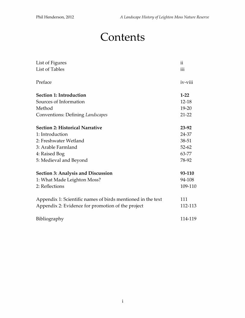
Contents
List of Figures ii
List of Tables iii
Preface iv-viii
Section 1: Introduction 1-22
Sources of Information 12-18
Method 19-20
Conventions: Defining Landscapes 21-22
Section 2: Historical Narrative 23-92
1: Introduction 24-37
2: Freshwater Wetland 38-51
3: Arable Farmland 52-62
4: Raised Bog 63-77
5: Medieval and Beyond 78-92
Section 3: Analysis and Discussion 93-110
1: What Made Leighton Moss? 94-108
2: Reflections 109-110
Appendix 1: Scientific names of birds mentioned in the text 111
Appendix 2: Evidence for promotion of the project 112-113
Bibliography 114-119
Phil Henderson, 2012 A Landscape History of Leighton Moss Nature Reserve
ii
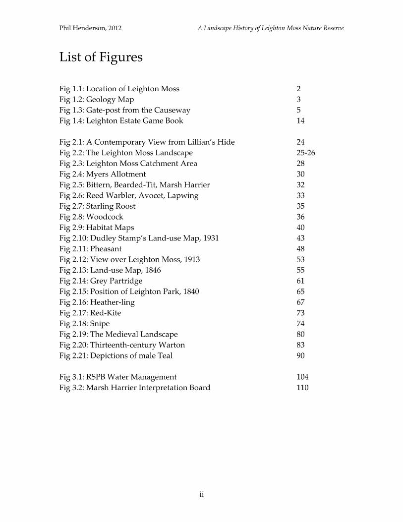
List of Figures
Fig 1.1: Location of Leighton Moss 2
Fig 1.2: Geology Map 3
Fig 1.3: Gate-post from the Causeway 5
Fig 1.4: Leighton Estate Game Book 14
Fig 2.1: A Contemporary View from Lillian’s Hide 24
Fig 2.2: The Leighton Moss Landscape 25-26
Fig 2.3: Leighton Moss Catchment Area 28
Fig 2.4: Myers Allotment 30
Fig 2.5: Bittern, Bearded-Tit, Marsh Harrier 32
Fig 2.6: Reed Warbler, Avocet, Lapwing 33
Fig 2.7: Starling Roost 35
Fig 2.8: Woodcock 36
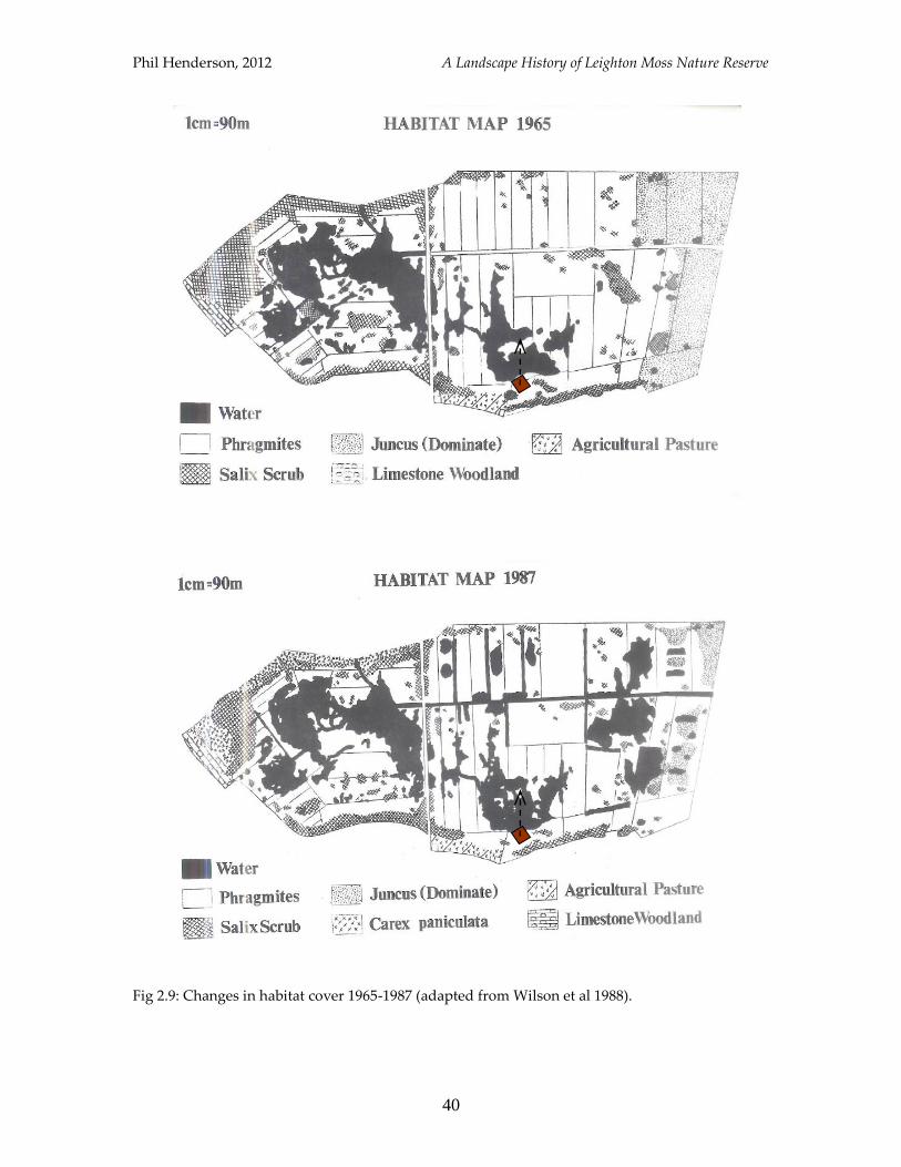
Fig 2.9: Habitat Maps 40
Fig 2.10: Dudley Stamp’s Land-use Map, 1931 43
Fig 2.11: Pheasant 48
Fig 2.12: View over Leighton Moss, 1913 53
Fig 2.13: Land-use Map, 1846 55
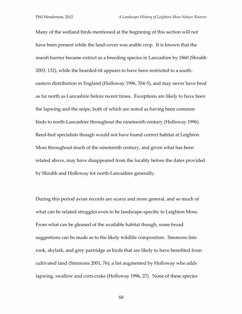
Fig 2.14: Grey Partridge 61
Fig 2.15: Position of Leighton Park, 1840 65
Fig 2.16: Heather-ling 67
Fig 2.17: Red-Kite 73
Fig 2.18: Snipe 74
Fig 2.19: The Medieval Landscape 80
Fig 2.20: Thirteenth-century Warton 83
Fig 2.21: Depictions of male Teal 90
Fig 3.1: RSPB Water Management 104
Fig 3.2: Marsh Harrier Interpretation Board 110
Phil Henderson, 2012 A Landscape History of Leighton Moss Nature Reserve
iii
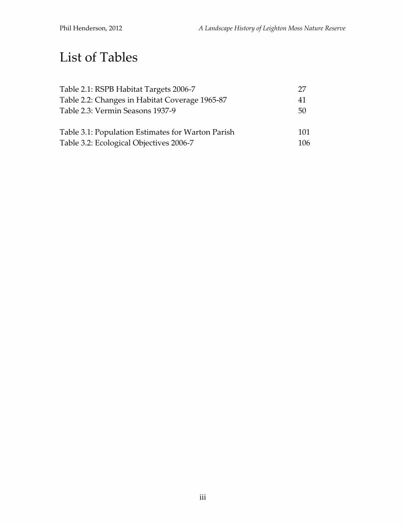
List of Tables
Table 2.1: RSPB Habitat Targets 2006-7 27
Table 2.2: Changes in Habitat Coverage 1965-87 41
Table 2.3: Vermin Seasons 1937-9 50
Table 3.1: Population Estimates for Warton Parish 101
Table 3.2: Ecological Objectives 2006-7 106

Phil Henderson, 2012 A Landscape History of Leighton Moss Nature Reserve
iv
Preface
This research project was devised after having spent nine months as a voluntary
warden with the RSPB (Royal Society for the Protection of Birds) at Leighton
Moss Nature Reserve, during 2010-11. Much of the visitor engagement
programme was tailored around the reserve’s specialist flora and fauna, and the
management undertaken by the RSPB towards the enhancement of it. The history
of Leighton Moss though was never made a main feature of guided walks, school
visits, or attempts to broaden the reserve’s appeal to potential guests and
supporters, despite its massive potential. It is felt that the historic dimension
could be exploited more fully not only to promote the site and the organisation,
but also to enforce links to the wider landscape for the betterment of the human
and non-human communities that abide there.
It is the concern of this work to provide a historical context for Leighton Moss
and its environs - a landscape history - that also incorporates a look at some of
the characteristic species present at particular junctures, given prevailing habitat
conditions and land-uses. The underlying processes involved in physical
landscape change and species composition will also be examined, placing this
Phil Henderson, 2012 A Landscape History of Leighton Moss Nature Reserve
v
work into the academic realms of historical ecology, archaeology and nature
conservation (specifically wetland archaeology), and a more broad school of
historic landscape investigation.
The approach, main sources of information and structure will be explained in
detail in the introductory chapter, but a brief word on style is required here. The
chief stylistic ambition has been to achieve simplicity so as to make all discussion
and diagrams accessible and appealing to a wide audience. Specialist software
such as GIS has therefore not been made use of, as it is not readily available in
non-academic circles, and so goes against the underlying ethos of this piece: that
anyone and everyone should feel empowered to write on local history. It was
also felt that the use of GIS in particular would complicate the study by
introducing another means of viewing the landscape; most maps and diagrams
are therefore derived from one source, the OL Explorer 7 Ordnance Survey map.
Brian Jones of the Mourholme Local History Society has applied for Heritage
Lottery funding for a project that will incorporate the use of GIS to map historic
features in the locality (pers. comm. 2012), so if a greater degree of spatial
analysis is sought, it may be afforded there.
Phil Henderson, 2012 A Landscape History of Leighton Moss Nature Reserve
vi
The scope of this work in terms of its spatial framework has been left undefined;
this was decided at the outset so as not to reduce the pool of available evidence,
or dilute the applicability of conclusions. There is a limit to the temporal range
of this study however, as the consulted evidence stretches only as far back as the
late Mesolithic period. The classification of time periods here will follow that
listed by Rackham for England (Rackham 1987, xvi), as below (note there is some
overlap between periods).
Mesolithic c. 10,000-4500 BC
Neolithic 4500-2000 BC
Bronze Age 2400-750 BC
Iron Age 750 BC-AD 40
Roman AD 40-410
Anglo-Saxon AD 410-1066
Medieval AD 1066-1536
Post-medieval AD 1536 onwards
Phil Henderson, 2012 A Landscape History of Leighton Moss Nature Reserve
vii
Acknowledgements
A number of people have helped to shape this project to its current form, offering
advice, guidance and encouragement throughout the research-process. Special
thanks are extended to: John Wilson, Richard Miller and Annabel Rushton of
RSPB Leighton Moss, for their time, encouragement, and for allowing access to
valuable information and resources. Annabel deserves particular mention for
providing a vital communication link throughout the project, and assistance at
every turn; Mrs Lucy Arthurs of Leighton Hall Estate, for kindly allowing access
to Game-keepers accounts; Peter Jones of Cumbria Wildlife Trust for valuable
discussion of reserves under his jurisdiction; Jenny Ager, Dorothy Clark, and
Brian and Sheila Jones of the Mourholme Local History Society, for helping in the
early stages of the project, enabling it to find a firm-footing; Mike and Jane
Malpass for providing many of the photographs contained in this work; the staff
at Lancashire Record Office for their patience in un-ravelling and re-ravelling
Tithe Maps on every research visit; and Kevin Walsh of the Archaeology
Department at York University, for continued advice, support and valuable
criticisms.
Phil Henderson, 2012 A Landscape History of Leighton Moss Nature Reserve
viii
Concessions
Due to time-constraints and financial limitations, which allowed only a finite
number of research excursions, it was not possible to examine all available
material, to follow every lead. Early on it became apparent that only after having
completed this project would it be possible to realise the full potential of the
evidence; so much more could be achieved, and this work should be seen as
something to build upon. Despite these limitations, it has been the author’s aim
to present and interpret consulted evidence impartially. Any and all mistakes in
this work are the author’s own.
Phil Henderson, 2012 A Landscape History of Leighton Moss Nature Reserve
1
1
Introduction
Phil Henderson, 2012 A Landscape History of Leighton Moss Nature Reserve
2
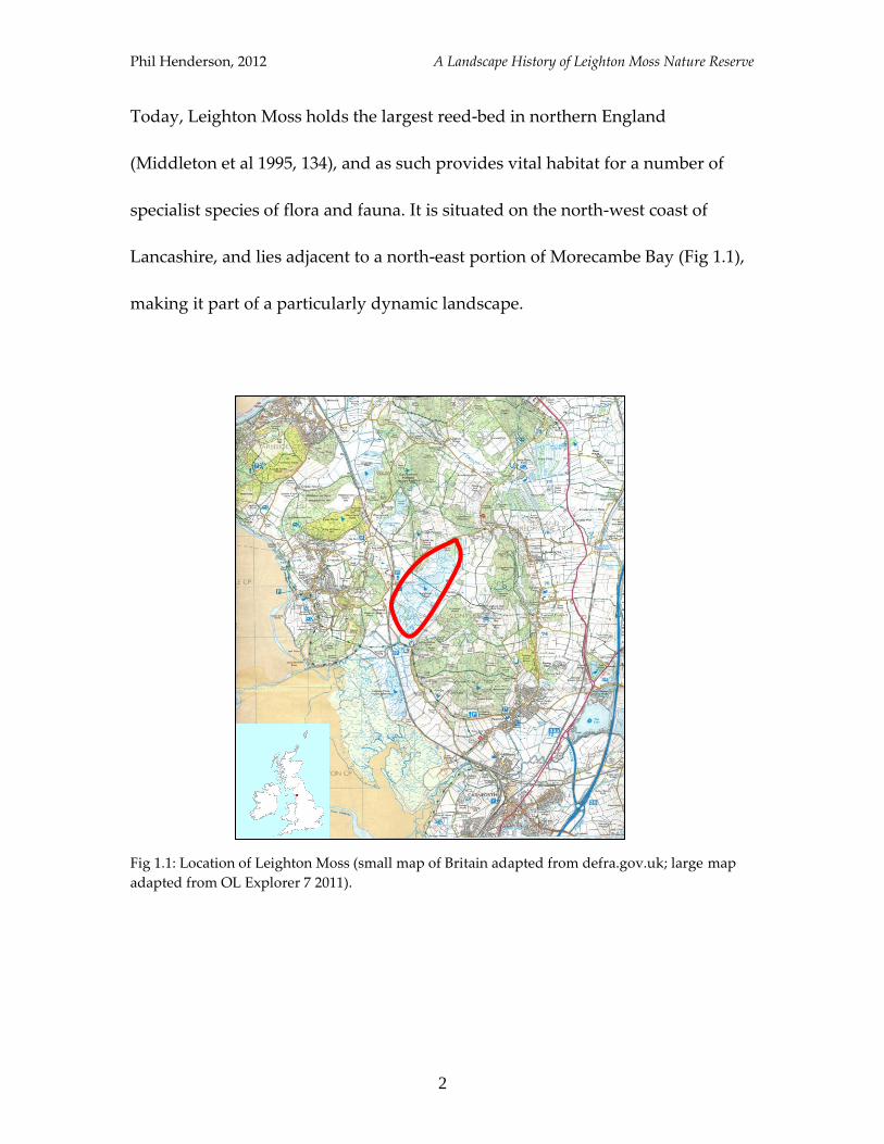
Today, Leighton Moss holds the largest reed-bed in northern England
(Middleton et al 1995, 134), and as such provides vital habitat for a number of
specialist species of flora and fauna. It is situated on the north-west coast of
Lancashire, and lies adjacent to a north-east portion of Morecambe Bay (Fig 1.1),
making it part of a particularly dynamic landscape.
Fig 1.1: Location of Leighton Moss (small map of Britain adapted from defra.gov.uk; large map
adapted from OL Explorer 7 2011).
Phil Henderson, 2012 A Landscape History of Leighton Moss Nature Reserve
3
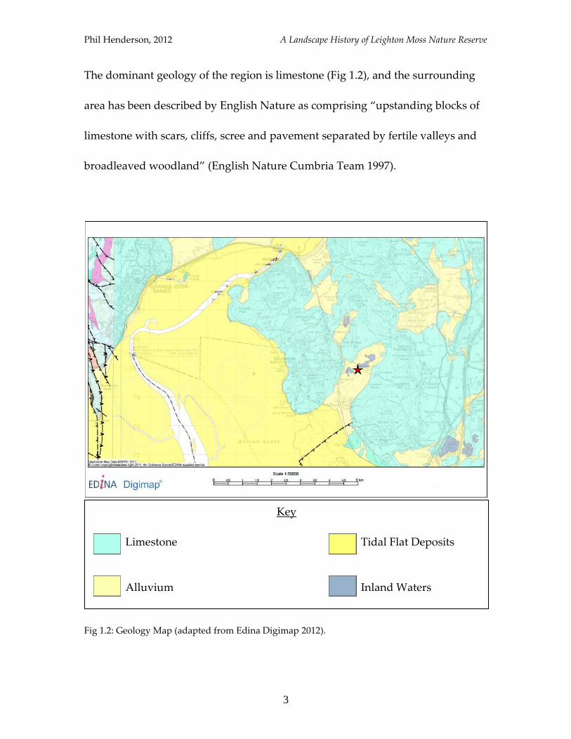
The dominant geology of the region is limestone (Fig 1.2), and the surrounding
area has been described by English Nature as comprising “upstanding blocks of
limestone with scars, cliffs, scree and pavement separated by fertile valleys and
broadleaved woodland” (English Nature Cumbria Team 1997).
Fig 1.2: Geology Map (adapted from Edina Digimap 2012).
Key
Limestone Tidal Flat Deposits
Alluvium Inland Waters
Phil Henderson, 2012 A Landscape History of Leighton Moss Nature Reserve
4
The mosaic of habitats afforded by this diverse range of landscape forms sustains
a varied wildlife composition, and is conducive to a number of land uses. This
special character of the locality is pronounced by its classification in 1972 as part
of the Arnside/Silverdale AONB (Johnston 1986, 6), and Leighton Moss itself
being designated SSSI status (Middleton et al 1995, 134).
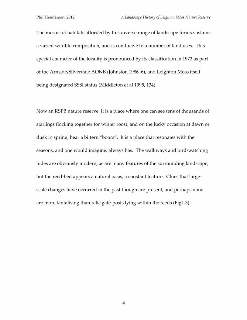
Now an RSPB nature reserve, it is a place where one can see tens of thousands of
starlings flocking together for winter roost, and on the lucky occasion at dawn or
dusk in spring, hear a bittern “boom”. It is a place that resonates with the
seasons, and one would imagine, always has. The walkways and bird-watching
hides are obviously modern, as are many features of the surrounding landscape,
but the reed-bed appears a natural oasis, a constant feature. Clues that large-
scale changes have occurred in the past though are present, and perhaps none
are more tantalising than relic gate-posts lying within the reeds (Fig1.3).
Phil Henderson, 2012 A Landscape History of Leighton Moss Nature Reserve
5
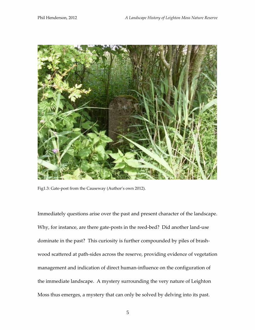
Fig1.3: Gate-post from the Causeway (Author’s own 2012).
Immediately questions arise over the past and present character of the landscape.
Why, for instance, are there gate-posts in the reed-bed? Did another land-use
dominate in the past? This curiosity is further compounded by piles of brash-
wood scattered at path-sides across the reserve, providing evidence of vegetation
management and indication of direct human-influence on the configuration of
the immediate landscape. A mystery surrounding the very nature of Leighton
Moss thus emerges, a mystery that can only be solved by delving into its past.

Phil Henderson, 2012 A Landscape History of Leighton Moss Nature Reserve
6
In a broad sense, the aim of this work is to solve this mystery; to chart the history
of Leighton Moss and its environs, and to reveal the main influences that have
acted to create current landscape form. Throughout, the landscape will be
scrutinized for the habitat mosaic it provides, with changes therein being viewed
as the evolution and revolution of habitat. Changes in the composition of
wildlife – non-domestic animals - will be chronicled in tandem, allowing for links
to be made between landscape configuration, wildlife distribution and the
processes that have combined to determine both. The results of this study will
therefore be directly relevant to nature conservation, indicating which species
inhabited the area in the past, and perhaps highlighting which species should be
safe-guarded in the present (Robinson 1985, 11) – or at least which conditions
should be safeguarded.
The potential to apply results of historical research to management of nature
reserves is becoming increasingly acknowledged, and evidence that this is a
highly topical issue today has been provided by Peter Jones, Reserves Officer
with Cumbria Wildlife Trust. It transpires that there is archaeological interest in
the Brown Robin reserve near Grange-over-sands in Cumbria, which contains
evidence of land-use thought to date back to at least the early Industrial
Revolution (pers. comm. 2012). Multi-stemmed mature trees provide evidence of
Phil Henderson, 2012 A Landscape History of Leighton Moss Nature Reserve
7
an abandoned coppice, while damage to the limestone-pavement implies
extraction of limestone. The implications for management of what is known of
the reserve’s history are detailed below:
“The history of the site [Brown Robin reserve]… gives insights into what habitats
and species were traditionally there. We know that fritillary butterflies used to
be on the site. Why are they not now? Knowing that there used to be lots of
coppicing going on there tells us that when the coppicing stopped, the habitat
became unsuitable for them and they disappeared. By coppicing now we are
hoping to get them back on the reserve” (pers. comm. Peter Jones 2012).
So the pertinence of historical research to nature conservation is not simply a
hypothesis, but an accepted and embraced fact. It is also an issue dealt with in
the academic discipline of historical ecology, which is concerned with drawing
out the intricacies of the human/environment relationship by moving away from
mono-causal explanations of change, and more recently, providing “reference
ecosystems” (Egan and Howell 2001), from which conservationists may base
ecological management. This current work most readily falls into the categories
of landscape history and nature conservation and historical ecology, but there are
many other schools of thought to which it could be linked.
In terms of structure, what follows is a two-part investigation into the history of
Leighton Moss. The first section will form a historical narrative, moving
Phil Henderson, 2012 A Landscape History of Leighton Moss Nature Reserve
8
chronologically from present to prehistory, presenting evidence for change on a
landscape-scale through time, and examining the concomitant make-up of flora
and fauna. The first chapter of this section will begin by relating the current
configuration of land forms and features, introducing the main stake-holders and
users of the land. The current wildlife composition will be discussed, with a
focus throughout on avifauna (birds). With a large proportion of visitors to the
reserve, and supporters of the RSPB at large, being avid bird-watchers, it seemed
fitting that the spotlight for this foray should be placed on birds.
The remaining chapters in the first section will explore what is known of the
reserve’s disposition in the past. Chapter two will move from the 21st century to
the early 20th, and will see Leighton Moss transformed from reed-bed to a large
freshwater lake; chapter three will continue the story and see the freshwater lake
become productive arable land - and a terrestrial habitat - up to the early
nineteenth century; chapter four presents evidence from the mid-eighteenth
century, revealing a raised bog, and giving for the first time some indication of
the vegetation cover of the Moss in this period, querying the findings of the
North-West Wetlands Survey (Middleton et al 1995) in the process; chapter five
will complete the historical narrative by revealing what glimpses exist of the area
from the medieval period up to prehistory.
Phil Henderson, 2012 A Landscape History of Leighton Moss Nature Reserve
9
The first section will also attempt to provide “views” of the landscape, which
aim to impress how the land may have looked at various points in the past, given
the dominant vegetation cover. A fixed point in the contemporary landscape,
Lillian’s hide, has been chosen as a reference point for these views, offering
perhaps the best-known vantage-point on the reserve today, and thus providing
a familiar frame of reference to patrons. Allusion to how the land may have
physically looked will be afforded only up-to the eighteenth-century, beyond
which time consulted evidence is too scant for the attempt to be made. Glimpses
to fuel the imagination will though be provided of a history further removed.
The second section of this work will attempt to analyse the constructed narrative,
working counter-clockwise from the past to the present. This is so as to follow
changes as they occurred, as obviously, processes do not happen backwards
(even if due to cyclical rhythms they can manifest themselves to this effect). The
interplay between facets such as geology, climate, and sea-level fluctuations will
be appraised alongside human-induced factors such as land-use, management
and legislation.
It is in this section that key concepts associated with historical ecology will come
into play as analytical tools. Two concepts of particular relevance are: heterachy -
Phil Henderson, 2012 A Landscape History of Leighton Moss Nature Reserve
10
the notion that relationships between humans and the environment are
reciprocal, rather than determinant or hierarchical (Meyer & Crumley 2011, 120);
and Balee’s “tripartite division of human time” (Balee 2006, 80), which comprises
events, cycles, and long duree (interaction over large time-scales). This section
will argue that water, and the manipulation of it through time, has been
instrumental in forming the current landscape. It will end with a look at how the
findings of this project could be used, and discuss the potential for extending the
remit of research in future.
What follows is predominantly a desk-based analysis of evidence, though
previous experience of the Leighton Moss landscape has allowed for a high
resolution of interpretation. The gate-posts mentioned at the top of this piece, for
instance, were not identified by the rapid survey undertaken for English
Heritage’s PastScape project (English Heritage 2012), due to both access
restrictions and the camouflage afforded to these features by the dense covering
of reeds. The strength of local knowledge thus becomes apparent to a holistic
exercise such as this.
In its approach this study could be labelled as “standard”, as its concern is with
physical changes in land-form and configuration, rather than the way in which
Phil Henderson, 2012 A Landscape History of Leighton Moss Nature Reserve
11
these features would have been perceived by their human inhabitants (Tilley
1994, 11). The landscape experience will though be commented on for the way in
which it has altered perceptions and thereby the human-wildlife-habitat
relationship. A more phenomenological approach could be applied in future,
but any findings would need to be viewed with caution given the differential
survival and acknowledgement of historical evidence; it would be very difficult
to claim understanding of, for instance, the significance of certain features in the
landscape versus others, without a fully intact landscape. Williamson
demonstrates this assertion clearly in discussion of evidence for intermediate
exploitation of animals, showing that physical remains of rabbit warrens survive
as “pillow-mounds” in the landscape, while duck-decoys are remembered only
for the names that they bestow (Williamson 1997). Thus any form of landscape
interpretation must be undertaken with recognition that pieces of the puzzle are,
and will forever be, missing.
Phil Henderson, 2012 A Landscape History of Leighton Moss Nature Reserve
12
Sources of Information
Details regarding the history of the landscape and its human and non-human
inhabitants have been gleaned from a plethora of sources, covering topics
including local history, ecology, archaeology and environmental studies, as well
as primary documents. Below, the main sources of data consulted for this study
are divided into the main topics they cover; there is some overlap between the
categories each could be placed in.
Local Interest
A start-point of the data gathering process was making contact with those
individuals and organisations with a stake in the contemporary landscape, those
with indigenous knowledge. These included the RSPB, Leighton Hall Estate, and
the Mourholme Local History Society, all of which provided a different milieu
from which to start building-up a picture of landscape change. The RSPB
provided much information about habitat change, management and species
composition, at Leighton Moss and numerous other local sites in which they are
Phil Henderson, 2012 A Landscape History of Leighton Moss Nature Reserve
13
involved. Records stretch back to 1964, and of particular use was the 25th
anniversary reserve report, collated by John Wilson: Leighton Moss and Morecambe
Bay Reserve, Lancashire: the first 25 years, 1964-88 (Wilson et al 1988). Also
available are various Annual Reports, detailing management and monitoring
efforts more recently. These are public documents available on request, held by
the particular reserve to which they pertain.
Leighton Hall Estate owns much of the surrounding land to the Moss, and ceded
management, ownership and shooting rights to the RSPB, in 1964, ’74 and ’84
respectively (Wilson et al 1988, 3-5). As will be shown later, the estate is also the
likely supplier of the name “Leighton Moss”, which was apparently bestowed at
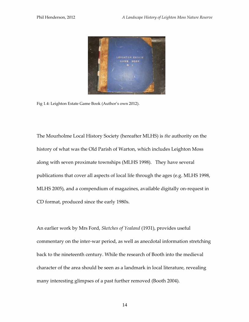
the turn of the nineteenth century. Permission to study the Game-keeper’s
accounts (Fig 1.4), which date back to 1923, was granted by the current owners,
and is a valuable indicator of changes in land-use and wildlife composition and
management since that date.
Phil Henderson, 2012 A Landscape History of Leighton Moss Nature Reserve
14
Fig 1.4: Leighton Estate Game Book (Author’s own 2012).
The Mourholme Local History Society (hereafter MLHS) is the authority on the
history of what was the Old Parish of Warton, which includes Leighton Moss
along with seven proximate townships (MLHS 1998). They have several
publications that cover all aspects of local life through the ages (e.g. MLHS 1998,
MLHS 2005), and a compendium of magazines, available digitally on-request in
CD format, produced since the early 1980s.
An earlier work by Mrs Ford, Sketches of Yealand (1931), provides useful
commentary on the inter-war period, as well as anecdotal information stretching
back to the nineteenth century. While the research of Booth into the medieval
character of the area should be seen as a landmark in local literature, revealing
many interesting glimpses of a past further removed (Booth 2004).
Phil Henderson, 2012 A Landscape History of Leighton Moss Nature Reserve
15
Archaeology
Archaeological investigation, replete with reports, has taken place in the vicinity
of the nature reserve, with excavations at Little Haweswater (Taylor et al 1994)
and Storrs Moss (Powell et al 1971) providing evidence of environmental
disposition in prehistory. Palaeoecological work was the central concern of these
investigations, with analysis of pollen cores allowing for recreation of vegetation
composition, and thus allusion to prevailing physical conditions. The online
Pastscape project, which has catalogued archaeological sites and finds across the
country, is also informative; over 400 historic features have been identified and
recorded within 5km of Leighton Moss (English Heritage 2012).
Two works are particularly noteworthy for dealing with the theme of
archaeology in the lowland wetlands of north-west England: The Wetlands of
North Lancashire (Middleton et al 1995) and Peat and the Past (Howard-Davis et al
1988). Issues relating to the relationship between nature conservation and
wetlands archaeology more broadly are well-covered in Wetlands Archaeology and
Nature Conservation (Cox et al 1994), while a collection of articles detailing the
general state of archaeological knowledge in Lancashire is also available
(Newman 1996).
Phil Henderson, 2012 A Landscape History of Leighton Moss Nature Reserve
16
Ecology
A wide range of source material concerned with the relationship between flora,
fauna and the environment is obtainable. The Ecology of Plant Communities
(Rieley & Page 1990) and The Biology of Freshwater Wetlands (Van der Valk 2006)
were found to be of particular use in relating the key characteristics of habitat
types. For information regarding the relationship between bird species and
particular habitats, Fuller’s Bird Habitats in Britain (1982) is an excellent resource,
and can be used handily alongside existing histories of Britain’s avifauna (see
Yalden & Albarella 2009; Shrubb 2003; Holloway 1996).
For volumes that deal more broadly with the history of British wildlife, Harting
(1972), Yalden (1996) and Lovegrove (2007) provide the most vivid accounts,
detailing the changing fortunes of non-domestic animals through time and
giving good allusion to primary source material.
Phil Henderson, 2012 A Landscape History of Leighton Moss Nature Reserve
17
Primary Sources
Many of the primary documents consulted here are housed at Lancashire Record
Office (hereafter LRO) in Preston. The most useful of which were Tithe Maps
and accompanying Tithe Schedules, dating from 1846. The maps provide the
spatial layout of the land, while the schedules detail land-use, such as arable
farmland or meadow, and so a recreation of the historic habitat mosaic can be
attempted. Church Wardens’ Accounts for Warton parish were also examined
there on microfiche, after Lovelock was able to demonstrate the use of such
accounts in discerning the history of British wildlife (Lovelock 2007). These are
lists of church expenditure, and include information on which species were being
persecuted, and critically when they were present to be persecuted. Enclosure
Awards are also housed in the archives at Preston, though due to time
constraints and the unwieldy nature of attendant paraphernalia, rigorous
examination did not take place.
The single most vital document for information regarding the eighteenth century
landscape is John Lucas’s History of Warton Parish (Ford & Fuller-Maitland, 1931).
It was compiled 1710-40, and close reading of its detail allows the vegetation
Phil Henderson, 2012 A Landscape History of Leighton Moss Nature Reserve
18
composition of Leighton Moss to be recreated for this period; a fact that has not
before been acknowledged.
Photocopies of vertical aerial photographs were obtained from English Heritage,
and digitised Ordnance Survey maps of various dates were accessed via the
online Edina Digimap service. In tandem, these items allow for examination of
landscape form and change from differing perspectives (the aerial photographs
were not rigorously examined here). In order to re-imagine how the land may
have looked from the ground, a call was also made for old photographs and
postcards, though few were uncovered. Copies of a poster asking for these were
displayed around the nature reserve; these were located in the RSPB visitor
centre, café, and in two of the hides (see Appendix 2). One poster was also
placed in the Post Office at Silverdale, and this request for pictorial evidence was
kindly posted digitally onto the RSPB Leighton Moss Community Forum by
Annabel Rushton (RSPB 2012). A final online resource worthy of note is the
British Newspaper Archive, which was accessed for historic copies of
newspapers including the Lancaster Gazette.
Phil Henderson, 2012 A Landscape History of Leighton Moss Nature Reserve
19
Method
Having made contact with the various stakeholders mentioned above, via email
and telephone conversations which in most cases led to face-to-face meetings, a
good idea as to the state of existing knowledge was established. Following on
from this, it became clear after exploration of archive material that Tithe Maps
and Schedules held the most potential for land-use analysis. The decision was
made to concentrate efforts on transferring data stored by these two mediums
onto an OS map of the same period – effectively re-creating the landscape of the
1840s that could be compared to a series of more modern maps. This was made
possible due to the nature of these sources: Tithe Maps record each strip of land
held in a given township, according each one with a number; Tithe Schedules
record using the same numerical-code, what the “state of cultivation” was for
each strip. It is therefore possible to determine where in the landscape parcels of
arable land were situated, in comparison with other land uses, such as pasture,
wood, plantation, meadow etc. The creation of a land-use map of this nature
could then be compared directly to other such models, such as that produced by
Stamp’s land-use survey of 1931 (to be discussed subsequently).
Phil Henderson, 2012 A Landscape History of Leighton Moss Nature Reserve
20
In order to create a land-use map for 1846, Tithe Maps of four townships were
examined: Silverdale, Yealand Conyers, Yealand Redmayne, and Warton-with-
Lindeth. The enormous size of (most) of these maps meant that the only way to
capture their detail was to physically copy them using tracing-paper. In total 27
sheets of A4 tracing-paper were used to record their data, and the land-use
information detailed in the Tithe Schedules for each township was noted. A
colour-code was then applied to each of the different “states of cultivation”, and
a historic OS map, obtained from Edina Digimap, was coloured-in accordingly.
Most other sources of information were more straightforward to access, and their
information was simply noted. Some documents though, such as John Lucas’
account, were afforded a closer degree of examination than others, due to the
high level of detail they could relate. Once the dominant vegetation cover and
land-uses had been discerned from historical and archaeological sources,
comments could be made as to the types of available habitat, and therefore what
the attendant composition of wildlife is likely to have been. An indication of
how the landscape may have looked and what species may have been seen it was
the desired result. This point leads rather nicely onto a brief discussion over the
definition of landscape; the term having already been deployed in a number of
ways to denote a number of things.
Phil Henderson, 2012 A Landscape History of Leighton Moss Nature Reserve
21
Conventions: Defining Landscapes
This brief discussion will examine some of the ways scholars have defined the
term landscape, but will be primarily concerned with how the concept will be
employed in this work. Landscape has been used above and throughout in two
main ways. Firstly, to denote the area around the site; a landscape history of
Leighton Moss will comprise a study of it and its surroundings. Secondly, the
term has been used to describe a particular view of the land; the gist of
everything that can be seen from a point of greater vantage. In a landscape view
the focus is relaxed, and sites merge to form one expansive sight. These two
classifications accord directly with the two “elements” that Johnson identifies as
forming a part of most definitions of the term (Johnson 2007, 4).
Now the fact that there is more than one connotation of the phrase will probably
be of little surprise, as landscape really has no definition of itself; it is defined
relative to other things, of which there are many. The instant association
conjured by the term, which for most involves some aspect of how the land looks,
is also the most apt descriptor for its wide ranging application; attempts to
Phil Henderson, 2012 A Landscape History of Leighton Moss Nature Reserve
22
further mark-out its definition often amount to nothing more than distinctions
without difference.
When it comes to analysing and interpreting physical features, grouped together
to form landscapes, the call for a more critical definition has been made. Authors
such as Tilley (1994) and Schama (1995) argue through their own examples that
landscapes are inherently cultural constructs, in that both their physical form and
classification according to this form, is determined by particular belief systems
that promote certain types of interaction. This is of course a reasonable assertion,
as are most others that deal with this issue, but the land is also subject to forces
acting independently of culture, and culture is not independent of these forces.
Thus it would seem that actually there is no one suitable definition of the term; in
fact there are several that could even be applied to the same area of land by the
same author, as here. One point that many authors make in common however is
that landscapes are palimpsests: they have been worked and re-worked through
time, retaining aspects of the past in their present form, and in many cases, have
been moulded by such remnants. This claim is particularly well illustrated by
the example of relic gate posts lying in the reed-bed.
Phil Henderson, 2012 A Landscape History of Leighton Moss Nature Reserve
23
2
Historical Narrative
Phil Henderson, 2012 A Landscape History of Leighton Moss Nature Reserve
24
1
Introduction
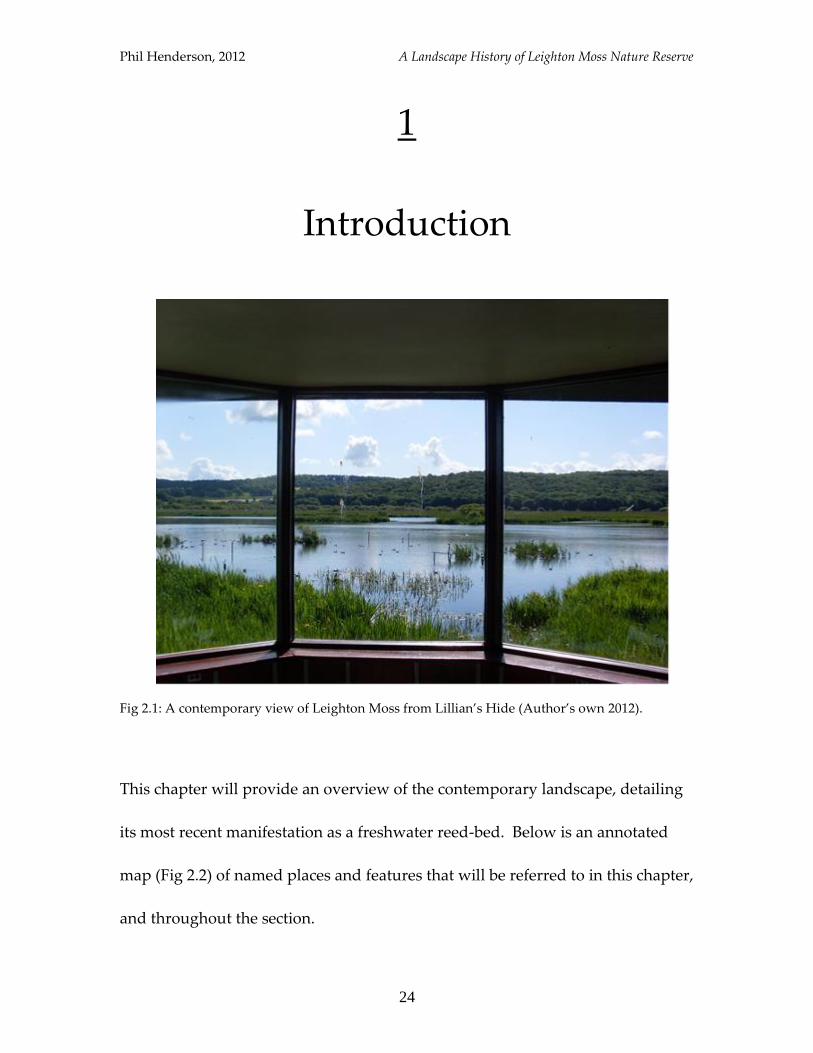
Fig 2.1: A contemporary view of Leighton Moss from Lillian’s Hide (Author’s own 2012).
This chapter will provide an overview of the contemporary landscape, detailing
its most recent manifestation as a freshwater reed-bed. Below is an annotated
map (Fig 2.2) of named places and features that will be referred to in this chapter,
and throughout the section.
Phil Henderson, 2012 A Landscape History of Leighton Moss Nature Reserve
25
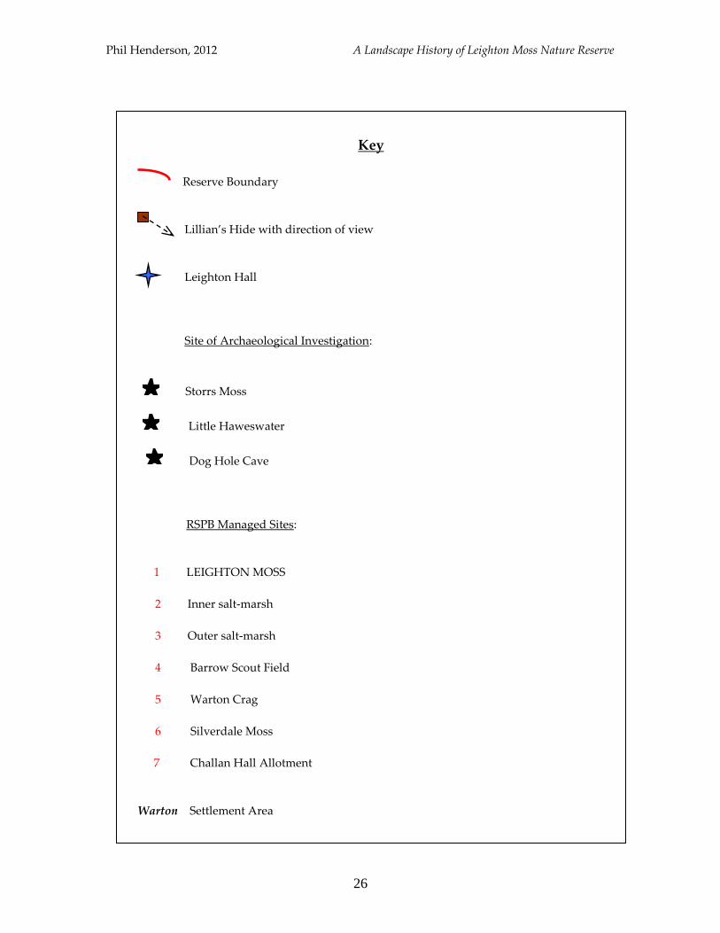
Fig 2.2: The Leighton Moss Landscape (small map of Britain adapted from defra.gov.uk; large
map adapted from OL Explorer 7 2011). Key overleaf.
Phil Henderson, 2012 A Landscape History of Leighton Moss Nature Reserve
26
Key
Reserve Boundary
Lillian’s Hide with direction of view
Leighton Hall
Site of Archaeological Investigation:
Storrs Moss
Little Haweswater
Dog Hole Cave
RSPB Managed Sites:
1 LEIGHTON MOSS
2 Inner salt-marsh
3 Outer salt-marsh
4 Barrow Scout Field
5 Warton Crag
6 Silverdale Moss
7 Challan Hall Allotment
Warton Settlement Area
Phil Henderson, 2012 A Landscape History of Leighton Moss Nature Reserve
27
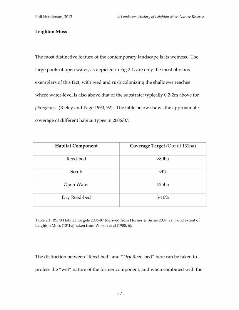
Leighton Moss
The most distinctive feature of the contemporary landscape is its wetness. The
large pools of open water, as depicted in Fig 2.1, are only the most obvious
exemplars of this fact, with reed and rush colonizing the shallower reaches
where water-level is also above that of the substrate; typically 0.2-2m above for
phragmites (Rieley and Page 1990, 92). The table below shows the approximate
coverage of different habitat types in 2006/07:
Habitat Component Coverage Target (Out of 131ha)
Reed-bed >80ha
Scrub <4%
Open Water >25ha
Dry Reed-bed 5-10%
Table 2.1: RSPB Habitat Targets 2006-07 (derived from Horner & Birnie 2007, 2). Total extent of
Leighton Moss (131ha) taken from Wilson et al (1988, 6).
The distinction between “Reed-bed” and “Dry Reed-bed” here can be taken to
profess the “wet” nature of the former component, and when combined with the
Phil Henderson, 2012 A Landscape History of Leighton Moss Nature Reserve
28
area of land covered by open water, exemplifies the preponderance of a wet
landscape.
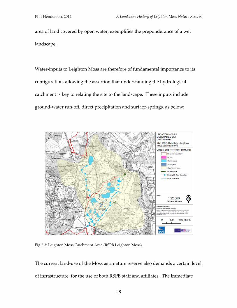
Water-inputs to Leighton Moss are therefore of fundamental importance to its
configuration, allowing the assertion that understanding the hydrological
catchment is key to relating the site to the landscape. These inputs include
ground-water run-off, direct precipitation and surface-springs, as below:
Fig 2.3: Leighton Moss Catchment Area (RSPB Leighton Moss).
The current land-use of the Moss as a nature reserve also demands a certain level
of infrastructure, for the use of both RSPB staff and affiliates. The immediate
Phil Henderson, 2012 A Landscape History of Leighton Moss Nature Reserve
29
landscape is therefore comprised of a network of paths that lead-out from the
RSPB visitors centre, and into the reed-bed. Bird-watching hides are a nodal
feature, allowing expansive views across the larger water-bodies on the reserve,
and a closer inspection of its wildlife.
The Wider Landscape
The environs of Leighton Moss are diverse in both their land-uses and forms.
The reserve is surrounded by pockets of farmland and woodland, with several
outlying sectors of the landscape also under some form of nature conservation
management. The main sites governed by the RSPB are outlined on the map
above (Fig 2.2), and show the interest in maintaining a mosaic of vegetation-
types over a large space. Silverdale Moss and Barrow-Scout Field are examples
of “satellite” reed-beds, providing subsidiary habitat to Leighton Moss for reed-
dwelling species. The inner and outer salt-marshes (I/O in subsequent reference
to avoid confusion with Silverdale salt-marsh) adjacent to the coast are also
particularly noteworthy for the distinctive flora and fauna they support, largely
influenced by the tidal cycles of Morecambe Bay and the dynamic regimes of the
rivers Kent to the north and Keer to the south.
Phil Henderson, 2012 A Landscape History of Leighton Moss Nature Reserve
30
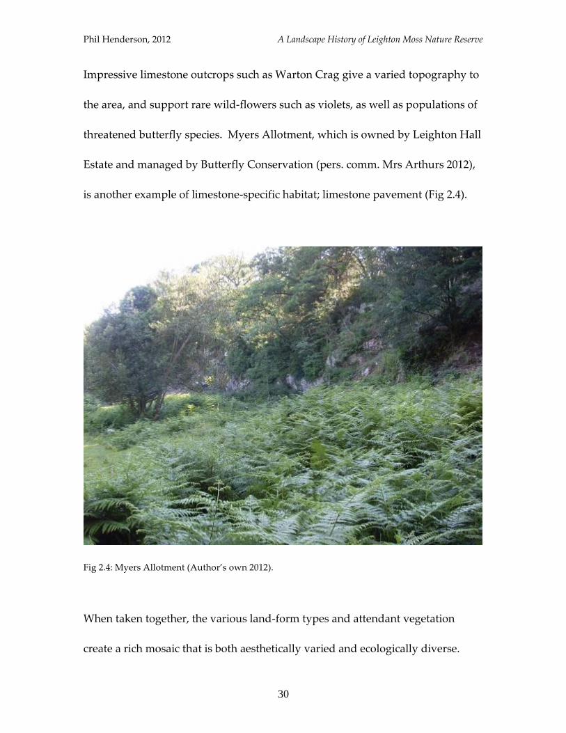
Impressive limestone outcrops such as Warton Crag give a varied topography to
the area, and support rare wild-flowers such as violets, as well as populations of
threatened butterfly species. Myers Allotment, which is owned by Leighton Hall
Estate and managed by Butterfly Conservation (pers. comm. Mrs Arthurs 2012),
is another example of limestone-specific habitat; limestone pavement (Fig 2.4).
Fig 2.4: Myers Allotment (Author’s own 2012).
When taken together, the various land-form types and attendant vegetation
create a rich mosaic that is both aesthetically varied and ecologically diverse.
Phil Henderson, 2012 A Landscape History of Leighton Moss Nature Reserve
31
The relationship between how the land looks, and what can be seen in it is a
strong one, and some examples of the characteristic wildlife prevalent today will
now be introduced.
Wildlife
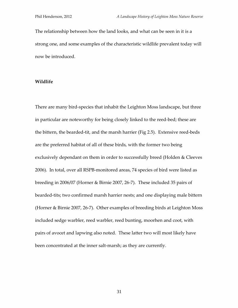
There are many bird-species that inhabit the Leighton Moss landscape, but three
in particular are noteworthy for being closely linked to the reed-bed; these are
the bittern, the bearded-tit, and the marsh harrier (Fig 2.5). Extensive reed-beds
are the preferred habitat of all of these birds, with the former two being
exclusively dependant on them in order to successfully breed (Holden & Cleeves
2006). In total, over all RSPB-monitored areas, 74 species of bird were listed as
breeding in 2006/07 (Horner & Birnie 2007, 26-7). These included 35 pairs of
bearded-tits; two confirmed marsh harrier nests; and one displaying male bittern
(Horner & Birnie 2007, 26-7). Other examples of breeding birds at Leighton Moss
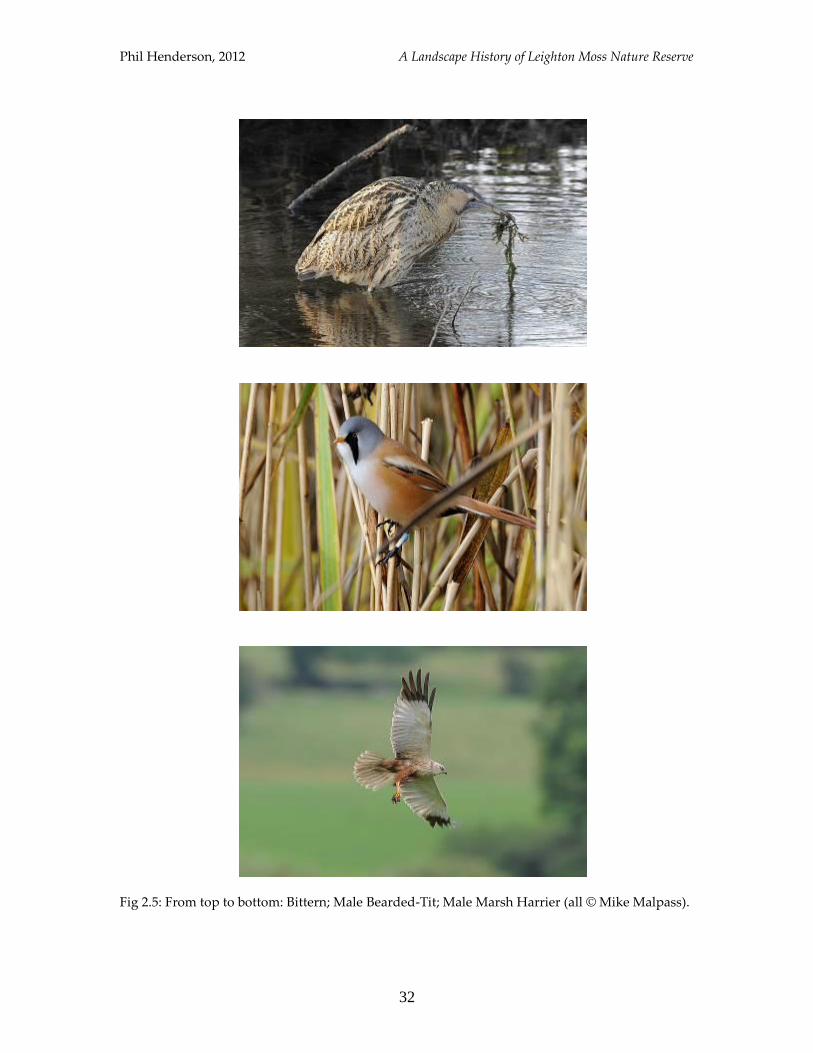
included sedge warbler, reed warbler, reed bunting, moorhen and coot, with
pairs of avocet and lapwing also noted. These latter two will most likely have
been concentrated at the inner salt-marsh; as they are currently.
Phil Henderson, 2012 A Landscape History of Leighton Moss Nature Reserve
32
Fig 2.5: From top to bottom: Bittern; Male Bearded-Tit; Male Marsh Harrier (all © Mike Malpass).
Phil Henderson, 2012 A Landscape History of Leighton Moss Nature Reserve
33
Fig 2.6: From top to bottom: Reed Warbler; Avocet; Lapwing (all © Mike Malpass).
Phil Henderson, 2012 A Landscape History of Leighton Moss Nature Reserve
34
Some of the species mentioned above are more conspicuous than others, and
their prominence in the landscape is also subject to change with the seasons. The
bittern for instance has a distinctive mating call, or “boom”, which it emits from
early spring in order to attract a mate. In favourable conditions, the call can be
heard up to three miles away from the bird making it (Wilson 1987, 5). The
lapwing and bearded-tit are also good examples of species that give a place a
distinctive acoustic character, with both birds having particularly recognizable
calls.
The seasonal aspect is important, as outside of the breeding season most species
stop singing and the composition of bird-life changes dramatically. This change
is even more pronounced at Leighton Moss due to the mix of habitats in close
proximity of each other. Fuller notes that for the intertidal zone and salt-
marshes: “the number of migrant and wintering bird species…is large by
comparison with the number of nesting species” (Fuller 1982, 21), and that “the
total populations of most lakes [and large water bodies]…are far greater in
winter than in summer” (Fuller 1982, 130). Leighton Moss typically sees a
substantial increase in the numbers of ducks in winter, such as pintail and
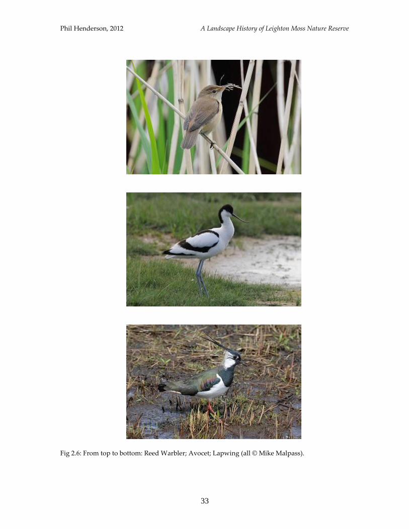
wigeon, while its marsh harriers migrate south. One notable spectacle associated
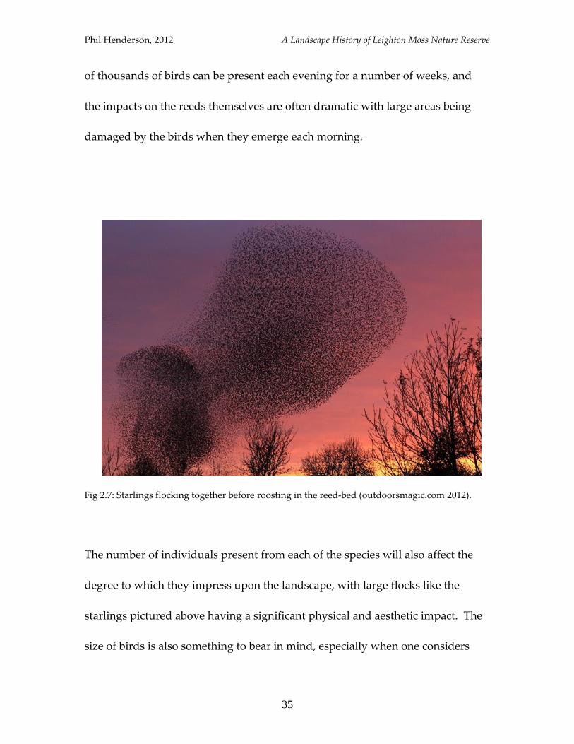
with the reed-bed during autumn and winter is the starling-roost (Fig 2.7); tens
Phil Henderson, 2012 A Landscape History of Leighton Moss Nature Reserve
35
of thousands of birds can be present each evening for a number of weeks, and
the impacts on the reeds themselves are often dramatic with large areas being
damaged by the birds when they emerge each morning.
Fig 2.7: Starlings flocking together before roosting in the reed-bed (outdoorsmagic.com 2012).
The number of individuals present from each of the species will also affect the
degree to which they impress upon the landscape, with large flocks like the
starlings pictured above having a significant physical and aesthetic impact. The
size of birds is also something to bear in mind, especially when one considers

Phil Henderson, 2012 A Landscape History of Leighton Moss Nature Reserve
36
that smaller species would have been much more difficult to recognise without
the use of binoculars, telescopes and cameras. The elusive nature of birds such
as the woodcock (Fig 2.8) also means that the presence of certain species is often
more understated than that of others, and so the appreciation of avifauna
composition in any place at any time will always be subject to a wide-range of
obscuring factors.
Fig 2.8: Woodcock (© Stanley Porter, RSPB-images.com).
Phil Henderson, 2012 A Landscape History of Leighton Moss Nature Reserve
37
Summary
A snippet of the contemporary landscape has been provided above, with allusion
to the diverse range of vegetation and species make-up that predominates today.
Leighton Moss is a freshwater wetland, dominated by tall stands of dense
vegetation, while the wider landscape hosts both terrestrial and marine
ecosystems and species. Taken together the combination of habitats afforded in
the vicinity supports a rich variety of sights and sounds, often associated with
birds. Mammals such as the otter and red deer are also present, and give further
indication of the high-diversity of the area.
Phil Henderson, 2012 A Landscape History of Leighton Moss Nature Reserve
38
2
Freshwater Wetland
This chapter will chart the history of Leighton Moss as a freshwater wetland.
The main focus will be the period under RSPB management, from1964 to present,
though there will be some allusion to the disposition of the Moss directly prior to
this era when, it will be shown, reed-growth and the colonisation of willow-
scrub vegetation was already at an advanced stage.
Evidence of some of the key changes in and around the reserve will be presented,
and will include the creation of satellite reed-beds and the extension of
freshwater pools at Leighton Moss. Small changes to vegetation structure occur
seasonally and annually, and while they are important, a work of this size and
resolution cannot deal with them all. Instead, snapshots of large-scale alterations
will be presented. Significant events in the wildlife make-up, such as the arrival
of marsh harriers and bearded-tits to the reserve, will also be related.
Phil Henderson, 2012 A Landscape History of Leighton Moss Nature Reserve
39
Leighton Moss
During its tenure as an RSPB nature reserve, the most striking change at
Leighton Moss has been the expansion of open water, and the reduction of
juncus in its place (see Fig 2.9) – juncus being the Latin name for rushes and
other such vegetation (Gilbert-Carter 1955, 44). This has been achieved through a
mixture of short-term, large-scale, management techniques such as the
deployment of heavy machinery to dredge the reed-bed (Wilson et al 1988), and
through continuous smaller scale management such as rotational reed-cutting
and coppicing of willow-scrub.
As evidenced by the habitat maps below, the reed-bed was much drier in 1965
than it was in 1987, especially in its western section (the approximate location of
Lillian’s hide has been added to aid with orientation). Drainage dykes were also
cleared of reed (Wilson et al 1988, 7) in order to facilitate water egress, and will
have provided new areas of reed-water interface in the process, which was a
particular ambition of management work (Wilson et al 1988, 7).
Phil Henderson, 2012 A Landscape History of Leighton Moss Nature Reserve
40
Fig 2.9: Changes in habitat cover 1965-1987 (adapted from Wilson et al 1988).
Phil Henderson, 2012 A Landscape History of Leighton Moss Nature Reserve
41
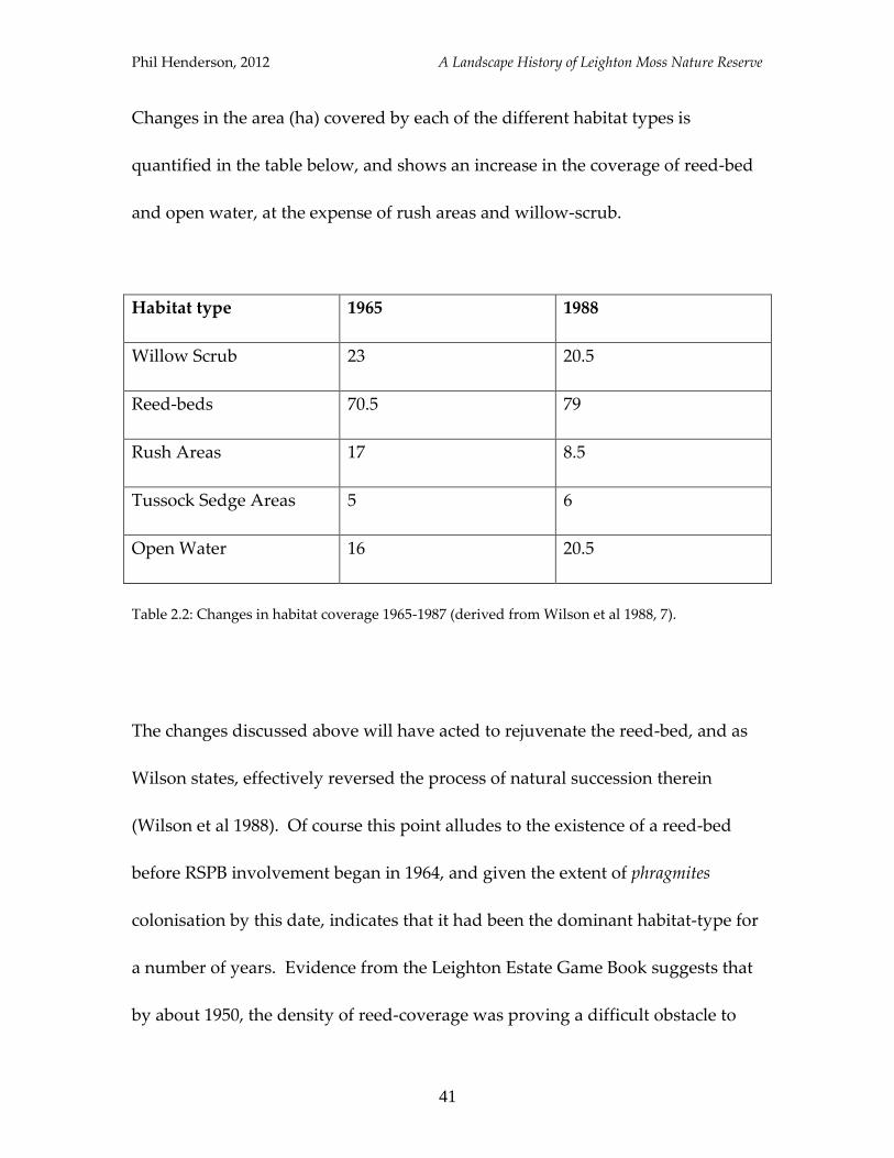
Changes in the area (ha) covered by each of the different habitat types is
quantified in the table below, and shows an increase in the coverage of reed-bed
and open water, at the expense of rush areas and willow-scrub.
Habitat type 1965 1988
Willow Scrub 23 20.5
Reed-beds 70.5 79
Rush Areas 17 8.5
Tussock Sedge Areas 5 6
Open Water 16 20.5
Table 2.2: Changes in habitat coverage 1965-1987 (derived from Wilson et al 1988, 7).
The changes discussed above will have acted to rejuvenate the reed-bed, and as
Wilson states, effectively reversed the process of natural succession therein
(Wilson et al 1988). Of course this point alludes to the existence of a reed-bed
before RSPB involvement began in 1964, and given the extent of phragmites
colonisation by this date, indicates that it had been the dominant habitat-type for
a number of years. Evidence from the Leighton Estate Game Book suggests that
by about 1950, the density of reed-coverage was proving a difficult obstacle to
Phil Henderson, 2012 A Landscape History of Leighton Moss Nature Reserve
42
wildfowling. In the 1923-4 season for instance, the number of coot, teal, and
mallard taken respectively were 391, 320 and 190; by 1951-2, figures for these
same species had been significantly reduced to 35, 178 and 118 (Leighton Estate
Game Book). There may of course have been other factors involved to account
for this lower yield, but Richard Gillow-Reynolds, the then owner of Leighton
Estate, states clearly that by the end of the Second World War, “reed growth
made picking up of wildfowl difficult” (Wilson et al 1988, 23). Thus perhaps
from the 1940s, the dominant feature of Leighton Moss was the reed-bed;
Middleton puts this date at 1939 (Middleton et al 1995, 134).
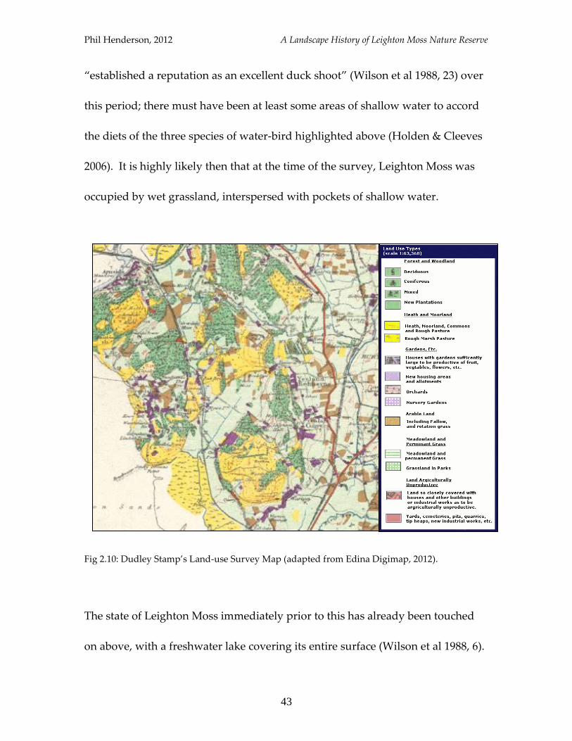
Interestingly, evidence for the disposition of Leighton Moss circa 1931 is
provided by a land-use map drawn up as part of Dudley Stamp’s land-use
survey (Fig2.10). It shows the Moss to be “meadowland and permanent grass”,
implying that the covering of reed was not so dense at this date. It is more
interesting though because according to the history of the site written by Richard
Gillow-Reynolds, Leighton Moss was dominated by a freshwater lake in 1918-9
(Wilson et al 1988,23), and so the implication is that vegetation had quickly
colonised between this date and that of the survey. Exactly what type of
vegetation “meadow” can be taken to represent is obscure though, and cannot
indicate expansive grassland in this case because, as alluded to above, the Moss
Phil Henderson, 2012 A Landscape History of Leighton Moss Nature Reserve
43
“established a reputation as an excellent duck shoot” (Wilson et al 1988, 23) over
this period; there must have been at least some areas of shallow water to accord
the diets of the three species of water-bird highlighted above (Holden & Cleeves
2006). It is highly likely then that at the time of the survey, Leighton Moss was
occupied by wet grassland, interspersed with pockets of shallow water.
Fig 2.10: Dudley Stamp’s Land-use Survey Map (adapted from Edina Digimap, 2012).
The state of Leighton Moss immediately prior to this has already been touched
on above, with a freshwater lake covering its entire surface (Wilson et al 1988, 6).
Phil Henderson, 2012 A Landscape History of Leighton Moss Nature Reserve
44
The Wider Landscape
A number of land-form changes have occurred in the vicinity of Leighton Moss
since the mid-twentieth century. Two of the most substantive alterations have
occurred at Silverdale Moss and Barrow Scout Field, which have both been
transformed to reed-bed within the last ten years. Photographs held at
Lancashire Record Office show Barrow Scout Field before operations began, and
at various stages throughout the RSPB’s project (LRO, RSPB Leighton Moss).
From these it would appear that grassland was the dominant vegetation cover
prior to development, with bunds and ditches becoming part of the landscape in
the process of its transformation from hard-land to wetland (LRO, RSPB
Leighton Moss). In 2000 the RSPB liaised with Lancaster University’s
archaeological unit, seeking a field-walk survey to be undertaken at the end of
each phase of the project “due to the presence of a potentially historic salt-pan”
(LRO, RSPB Leighton Moss). Construction work was completed in 2001, and no
archaeological remains were discovered throughout the process. This episode
not only provides evidence of physical land-form change, through the
conversion of grassland to reed-bed, and allusion of salt-workings sometime in
the past, but also demonstrates neatly a further role of archaeology in nature
conservation; giving the go-ahead to large-scale planning projects.
Phil Henderson, 2012 A Landscape History of Leighton Moss Nature Reserve
45
Over 2006/07, 22,000 reed plugs were planted between the two newly created
satellite reed-beds, with the majority being concentrated on Barrow Scout Field
due to it having a more favourable water-level to reed colonisation (Horner &
Birnie 2007, 4). These two areas in particular have seen profound changes in
their vegetation-structure in little more than a decade. Another zone that has
seen recent modification is Challan Hall Allotment, whereat the removal of
“alien” tree species such as sycamore and Scots pine has been underway for a
number of years (Horner & Birnie 2007, 7). The removal of large trees such as
these will of course have dramatic impacts on how the land looks.
The extent of the salt-marsh (I/O) has also waxed and waned considerably since
the 1960s, with rapid erosion taking place 1976-81 (Wilson et al 1988, 25). More
than two-thirds of the salt-marsh at Silverdale was also lost between 1967 and ’96
(MLHS 1998, 19), with very little remnant of it in existence today. This erosion is
caused by sideways shifts of the major channel in the Kent estuary, a process
well summarised by Pringle: “when the channel lay on the eastern side of the
estuary erosion occurred at Silverdale, but when it moved to the western Grange
side accretion took place here [Silverdale]” (Wilson et al 1988, 25). Thus the
dynamic nature of the coastal aspect of this landscape is made apparent.
Phil Henderson, 2012 A Landscape History of Leighton Moss Nature Reserve
46
A further adjustment worthy of note, which had a profound impact on the
composition of wildlife in the immediate vicinity, was the canalisation and
embanking of the river Keer in the late 1950s (Woods 1997, 8-9). Prior to this,
Woods relates that the Keer valley was subject to seasonal flooding, which
created water meadows in the Dockacre and Baderholme areas; the river-banks
themselves also supported ash, alder and crack-willow trees (Woods 1997, 8). As
part of the canalising-process, much of the vegetation, including the
aforementioned trees, was removed from the river-banks, and the water-table in
the Keer valley was lowered through the sinking of five water bore-holes (Woods
1997, 9). It becomes apparent then that the sum-landscape modification since the
mid-twentieth century has been dramatic, with Leighton Moss, Barrow Scout
Field and Silverdale Moss becoming “wetter”, the Keer valley becoming drier,
and less-well vegetated, and the salt-marsh at Silverdale almost completely
disappearing.
Wildlife
For the period under scrutiny here, it is possible to distinguish changes in
wildlife composition between Leighton Moss and its surrounding area. On the
reserve itself, the number of breeding bitterns increased from five to six pairs at
Phil Henderson, 2012 A Landscape History of Leighton Moss Nature Reserve
47
its establishment, to 11-12 pairs by 1981 (Wilson et al 1988, 10), falling again
“after a succession of cold winters and two very dry summers” (Wilson et al
1988, 10). Bearded-tits and marsh harriers were not counted amongst the
resident avifauna in 1964 (Wilson et al 1988, 3), but are a much more common
species at Leighton Moss today than the bittern is. Bearded-tits first colonised in
1973, with numbers building up to between 20-30 pairs by the 1980s (Wilson et al
1988, 10), while the first marsh harrier pair bred in 1987, raising three young
(Wilson et al 1988, 69). Marsh harriers were a regular sight at the reserve before
this date, but attendant only as summer migrants (Wilson et al 1988, 69). This
seasonal variation in species composition is of course a factor of bird’s biology,
but fluctuations in summer arrival dates for the marsh harrier suggest that
climate is also a determining factor of movements. For the twelve-year period
between 1976 and ’88, the earliest arrival date (5th April) was separated by almost
a month from the latest arrival date (3rd May) (Wilson et al 1988); thus providing
evidence that when a bird maybe present in the landscape can alter radically over
a relatively short time-period.
The number of freshwater wading-birds increased in-line with the provision of
larger areas of shallow water (Wilson et al 1988, 10), while this development also
saw the colonisation of the reed-bed by pochard and tufted duck (Wilson et al
Phil Henderson, 2012 A Landscape History of Leighton Moss Nature Reserve
48
1988, 16). The creation of artificial islands, in providing safe sites inaccessible to
terrestrial predators, encouraged nesting of a number of species, including coot,
moorhen, and lapwing, as well as a number of duck and gull-species (Wilson et
al 1988, 8).
In the wider landscape, a conspicuous change since the mid-twentieth century
has been the exponential increase in the number of pheasants present. This has
come largely as a result of rearing and releasing by Leighton Hall Estate. For
instance, between 1977-8, 2,000 pheasants were “put in woods” by the keepers;
this number had increased to 5,500 by 2004-5 (Leighton Hall Game Book). This
increase no doubt reflects changes in land-use and sources of revenue, with
pheasant-shoots taking place annually.
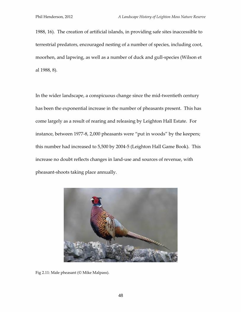
Fig 2.11: Male pheasant (© Mike Malpass).
Phil Henderson, 2012 A Landscape History of Leighton Moss Nature Reserve
49
Certainly it would seem that the transformation of the Keer meadows had a
profound impact on wildlife composition there. Woods had the following to say
for the period prior to canalisation:
“…otters were common, king fishers and sand-martins nested in the river-banks,
dippers nested under most bridges, conveys of partridges were about and corn-
crakes nested in the surrounding meadows. The hay meadows were also feeding
grounds for thousands of butterflies” (Woods 1997, 8).
Corn-crakes and partridges are not familiar birds in the locality nowadays, with
the latter being described as an uncommon species in Wilson’s work (1988, 72).
Although the mammalian composition is not the main focus here, it is worth
noting that the reserve was re-colonised by otter in 2006-7 (Horner & Birnie 2007,
16). Also, it is likely that a similar blend of terrestrial animals that prevail today
were also present throughout the twentieth century, given details held at
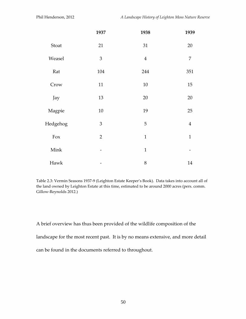
Leighton Hall. A list of vermin taken by keepers of Leighton Estate between
1937-9 is instructive for which species were present, and in what numbers:
Phil Henderson, 2012 A Landscape History of Leighton Moss Nature Reserve
50
1937 1938 1939
Stoat 21 31 20
Weasel 3 4 7
Rat 104 244 351
Crow 11 10 15
Jay 13 20 20
Magpie 10 19 25
Hedgehog 3 5 4
Fox 2 1 1
Mink - 1 -
Hawk - 8 14
Table 2.3: Vermin Seasons 1937-9 (Leighton Estate Keeper’s Book). Data takes into account all of
the land owned by Leighton Estate at this time, estimated to be around 2000 acres (pers. comm.
Gillow-Reynolds 2012.)
A brief overview has thus been provided of the wildlife composition of the
landscape for the most recent past. It is by no means extensive, and more detail
can be found in the documents referred to throughout.
Phil Henderson, 2012 A Landscape History of Leighton Moss Nature Reserve
51
Summary
It has been made apparent then that since the mid-twentieth century, there have
been a series of radical changes to both the habitat-types afforded by the
Leighton Moss landscape, and the composition of bird species within it. The
reed-bed itself has seen an increase in the area of open water, and the landscape
has seen two smaller reed-beds added. The Silverdale salt-marsh is all but gone
now, but the inner and outer salt-marshes remain extensive, with alterations to
the Keer floodplain having had a huge impact on the very nature of the
neighbouring land there, rendering it dry throughout the year.
These changes can be shown to have contributed to the alteration of avifauna
make-up, with notable losses including the common partridge and corn-crake,
and additions including the bearded-tit and marsh harrier as breeding species.
There are of course many other factors involved in changing distributions and
populations of wildlife, but the habitat afforded by an areas’ vegetation matrix
must surely be considered an important one.
Phil Henderson, 2012 A Landscape History of Leighton Moss Nature Reserve
52
3
Arable Farmland
In the previous chapter, the narrative was left at 1918-9, when it was related that
the dominant landscape feature of Leighton Moss was a freshwater lake. For
over a century prior to this, the Moss was an extremely productive tract of arable
farmland, known locally as the “Golden Bowl”, and as an excellent partridge-
shoot (Wilson et al 1988, 23). This chapter will recount what is known of
Leighton Moss and its attendant wildlife during this period.
Phil Henderson, 2012 A Landscape History of Leighton Moss Nature Reserve
53
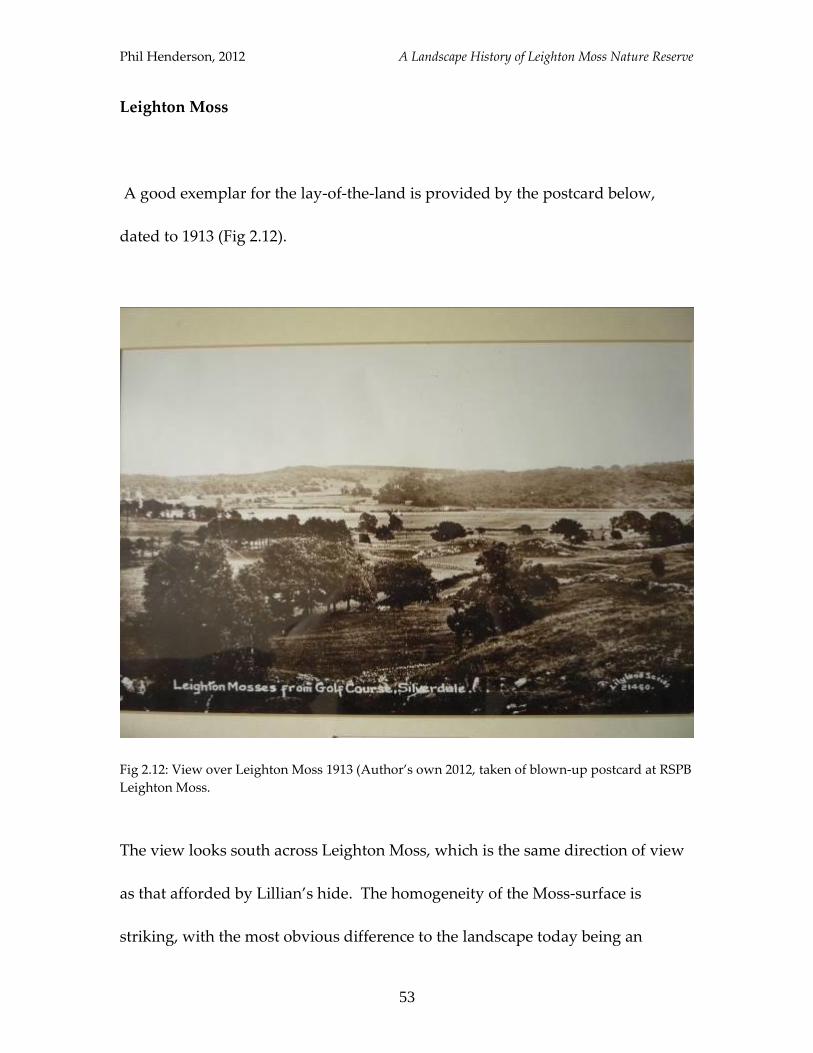
Leighton Moss
A good exemplar for the lay-of-the-land is provided by the postcard below,
dated to 1913 (Fig 2.12).
Fig 2.12: View over Leighton Moss 1913 (Author’s own 2012, taken of blown-up postcard at RSPB
Leighton Moss.
The view looks south across Leighton Moss, which is the same direction of view
as that afforded by Lillian’s hide. The homogeneity of the Moss-surface is
striking, with the most obvious difference to the landscape today being an
Phil Henderson, 2012 A Landscape History of Leighton Moss Nature Reserve
54
absence of open water. From the Tithe Schedule of Yealand Coniers dated 1846,
in which township Leighton Moss fell, oats, wheat, and barley appear to have
been the dominant crops (LRO, Yealand Coniers T/S). Whether this was still the
case in 1913 is not known for certain, but one can imagine that a dense crop of
any of these cereals, standing tall as they do, would closely resemble the
appearance of a dense stand of reeds; aside from the absence of open water, the
landscape may have appeared much the same as parts of the reed-bed today.
This could be especially true of the reed-bed in autumn/winter, when the reeds
change to a golden-yellow colour.
From the mid-1840s it would appear that Leighton Moss was under intensive
arable crop. Relating a flood event in October 1845, the Lancaster Gazette
records that: “The Moss lands about Leighton and Silverdale were very much
flooded, and as much corn is grown on it, a great quantity of grain in hattocks was
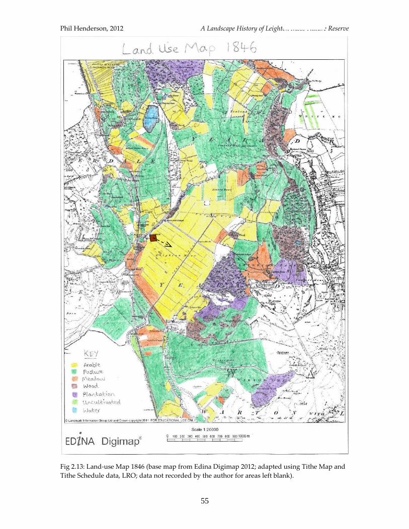
standing in water” (Lancaster Gazette 1845). The extent of land under arable
production is made clear by the map below (Fig 2.13), which characterises the
whole of the Moss as being in a state of arable cultivation.
Phil Henderson, 2012 A Landscape History of Leighton Moss Nature Reserve
55
Fig 2.13: Land-use Map 1846 (base map from Edina Digimap 2012; adapted using Tithe Map and
Tithe Schedule data, LRO; data not recorded by the author for areas left blank).
Phil Henderson, 2012 A Landscape History of Leighton Moss Nature Reserve
56
Now although there has been a marked shift to dry-land, it is apparent that
water management was still an important aspect of the landscape in the
nineteenth and early twentieth century. Apart from the flood event related
above, high-tides caused inundation of the Moss in 1842 (MLHS 2005, 25), 1852
(Ford 1931, 28) and 1907 (Ford 1931, 29). In an attempt to offset this problem, the
construction of an embankment towards the seaward-end of the Moss was
undertaken in 1840 (Middleton et al 1995, 134), without which it can be
speculated that more inundations would have occurred. Management of
freshwater entering Leighton Moss from the surrounding area was also ongoing,
manifesting itself physically as a series of drainage dykes, pumps and sluice
systems. Speaking of this management infrastructure, Middleton relates that:
“By 1848, perimeter dykes, to take surface run-off from surrounding slopes, had
been excavated and a pump installed at Crag Foot” (Middleton et al 1995, 134).
In 1890-1, a pump and tidal sluice were also installed at the seaward end of the
Moss (Middleton et al 1995, 134).
It is clear from consulted evidence that Leighton Moss was under some form of
arable cultivation from at least 1815, when the owner, a Mr Worswick, had
cropped it with oats, turnips, carrots and cabbage (MLHS 2005, 25). These latter
three examples are all low-growing vegetables; a fact which insinuates that
Phil Henderson, 2012 A Landscape History of Leighton Moss Nature Reserve
57
although the land was still arable by classification, it will have been quite
different in appearance. An estate map from Leighton Hall shows drainage
dykes at the south-western end of the Moss in 1804, and the causeway (which
still exists today) had already been constructed by this date (Middleton et al
1995, 134). These features suggest that the land was being readied for settlement
by farms at this time; an assertion that is corroborated by a “To Let” notice in the
Lancaster Gazette from the same year, which reads:
“All that compact and desirable farm, situate in Leighton, in the Parish of
Warton, in the county of Lancaster, called THE MOSS HOUSE; with the new-
built Dwelling house, Barn, Stable, Skippon, Garden, and from seventy to one
hundred acres (customary measure) of excellent land.
“And also, at the same time and place, will be LET in lots, several FIELDS and
PARCELS OF LAND, part of Leighton Hall Estate, and situate on the Northern
side of the Main Drain upon Leighton Moss. N.B. Nearly the whole of the said
farms and lands are tithe-free; and the same are well fenced and watered, and in
good cultivation” (Lancaster Gazette 1804, original emphasis throughout).
Thus it would seem that for much of the nineteenth century, Leighton Moss was
an expanse of arable fields, interspersed with drainage ditches and crossed by a
causeway. With fields ready to let in 1804, it is probable that these modifications
began even earlier in time, perhaps following Acts of Enclosure that occurred
across Warton Parish in the last decades of the eighteenth century. In 1776 for
instance, a scheme to enclose Yealand Redmayne Common was underway, with
Phil Henderson, 2012 A Landscape History of Leighton Moss Nature Reserve
58
a plan of the allotments it held, along with those of Storrs Moss (at the northern
end of Leighton Moss), drawn up as part of the enclosure process (LRO, Warton-
with-Lindeth E/A). Re-organization of lands neighbouring the Moss seem also to
have coincided with a re-shuffle of rights to it, with Leighton Estate buying-out
peat digging rights (Wilson et al 1988, 21), presumably before large-scale changes
occurred thereon. It is at this time, between the late eighteenth and early
nineteenth century, that the Moss appears to have gained the prefix “Leighton”,
presumably as entitlement now belonged solely to Leighton Estate.
The Wider Landscape
Alterations to the configuration of the wider landscape can be seen in part by
comparison of the two land-use maps depicted above. The starkest change
between 1846 and 1931 is actually the disposition of Leighton Moss, with
surrounding areas most often retaining their land-uses, typically in places under
pasture. The salt-marsh (I/O), clearly depicted by Stamp, was labelled as “sands”
in the Warton-with-Lindeth Tithe Schedule (LRO, Warton-with-Lindeth T/S),
perhaps indicating that the marsh had undergone a period of accretion since
1846. It is recorded that in 1840 Silverdale had a sand-beach, but that by the later
part of the century a salt-marsh had developed there(Wilson et al 1988, 25); this
Phil Henderson, 2012 A Landscape History of Leighton Moss Nature Reserve
59
would suggest that a period of salt-marsh growth occurred in the mid-nineteenth
century.
One significant change to the locality was the completion in 1857 of the
Ulverston to Carnforth Railway. According to Millward: “Its two great
embankments and iron viaducts stretching across the tidal sands of the Leven
and Kent, effectively broke the isolation of the peninsula” (Millward 1955, 118).
The ramifications of the rail-network will have been dramatic in opening-up the
area to the even wider landscape.
Wildlife
The wildlife composition of the area around Leighton Moss was quite different to
that of the present day. The bittern was lost as a breeding species in Lancashire
before 1845 (Shrubb 2003, 132), with its growing rarity being recognised by one
lecturer in a call for the establishment of museums:
“…the lecturer truly observed that the progress of improvement made the study
of natural history more difficult, in as much as in the case of the bittern, the
cultivation of land rendered observation of living species less and less
attainable…” (Lancaster Gazette 1851).
Phil Henderson, 2012 A Landscape History of Leighton Moss Nature Reserve
60
Many of the wetland birds mentioned at the beginning of this section will not
have been present while the land-cover was arable crop. It is known that the
marsh harrier became extinct as a breeding species in Lancashire by 1860 (Shrubb
2003, 132), while the bearded-tit appears to have been restricted to a south-
eastern distribution in England (Holloway 1996, 354-5), and may never have bred
as far north as Lancashire before recent times. Exceptions are likely to have been
the lapwing and the snipe, both of which are noted as having been common
birds to north-Lancashire throughout the nineteenth century (Holloway 1996).
Reed-bed specialists though would not have found correct habitat at Leighton
Moss throughout much of the nineteenth century, and given what has been
related above, may have disappeared from the locality before the dates provided
by Shrubb and Holloway for north-Lancashire generally.
During this period avian records are scarce and more general, and so much of
what can be related struggles even to be landscape-specific to Leighton Moss.
From what can be gleaned of the available habitat though, some broad
suggestions can be made as to the likely wildlife composition. Simmons lists
rook, skylark, and grey partridge as birds that are likely to have benefited from
cultivated land (Simmons 2001, 76); a list augmented by Holloway who adds
lapwing, swallow and corn-crake (Holloway 1996, 27). None of these species
Phil Henderson, 2012 A Landscape History of Leighton Moss Nature Reserve
61
seem too out-of-place, and the food source presented by arable crops will
probably have also led to an increase in finch populations (Shrubb 2003, 47).
Fig 2.14: Grey partridge (© Mike Langman, RSPB-images.com).
This period may also have seen the incidence of several mammal species that
have since ceased to be regular sights; namely, the wild-cat, pine marten, and
polecat. In his work, Yalden notes that the latter two had disappeared from
north-Lancashire by the early twentieth century, while the wild-cat is thought to
have vanished sometime in the early nineteenth (Yalden 1999, 177-9). It is also
noteworthy that the grey squirrel did not reach Lancashire before 1940 (Yalden
1999, 185).

Phil Henderson, 2012 A Landscape History of Leighton Moss Nature Reserve
62
Summary
Throughout the nineteenth century Leighton Moss was an area of arable
farmland. A complex water management system was in place, and the habitat
afforded was much different to that of the present day. Farmland birds such as
the grey partridge and corn crake were much more common, while for much of
the period, none of the three key species of the reserve today, namely the bittern,
marsh harrier and bearded-tit, were present as breeding species.
Phil Henderson, 2012 A Landscape History of Leighton Moss Nature Reserve
63
4
Raised Bog
Having left-off in the late eighteenth century in the previous chapter, and
witnessed the early stages of Leighton Moss’ transformation into productive
arable land, the story will pick-up in the mid-eighteenth century. Almost all of
the information related in this chapter originates from the writings of John Lucas,
who was born in Warton, and wrote a history of the parish between 1710 and
1740 (Fuller-Maitland 1931). From details provided it will be shown that
Leighton Moss at this time was actually known as Warton Moss, that it was used
as a source of peat-fuel for the inhabitants of that town, and that the dominant
vegetation cover was heather-ling. It will also be related that the bittern was a
common bird in the area, as were woodcock, snipe and lapwing. This chapter
will also include allusion to the sixteenth century disposition, and tell of the
episode that gave the Moss its title.
Phil Henderson, 2012 A Landscape History of Leighton Moss Nature Reserve
64
Leighton Moss
When John Lucas wrote his history “Leighton” Moss did not exist. A thorough
examination of his work reveals no reference to a place of this name, but of
course, in the absence of an enormous rise in sea-level, it must have existed (no
evidence has been unearthed to suggest such a rise in sea-level!). Now given that
the last-known owners of the Moss were Leighton Hall Estate, and that Leighton
Hall lies close to the site under discussion, it seemed likely that it would be
described along with them (Lucas’ account is a geographical one). Warton Moss
is the only named Moss in the work to which a full description is afforded, and
comes directly after discussion of Leighton Park (Fuller-Maitland 1931, 84),
making it a candidate despite its title. This candidacy is strengthened by Lucas’
description of the position of the Moss in the landscape, and the reason for its
name:
“[Warton Moss] is adjacent to the North part of this [Leighton] Park, so called
from its furnishing Warton with fuel, and not that it is in that Township, tho’
joyning [sic] to it…” (Fuller-Maitland 1931, 84 [627]).
Phil Henderson, 2012 A Landscape History of Leighton Moss Nature Reserve
65
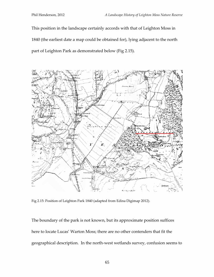
This position in the landscape certainly accords with that of Leighton Moss in
1840 (the earliest date a map could be obtained for), lying adjacent to the north
part of Leighton Park as demonstrated below (Fig 2.15).
Fig 2.15: Position of Leighton Park 1840 (adapted from Edina Digimap 2012).
The boundary of the park is not known, but its approximate position suffices
here to locate Lucas’ Warton Moss; there are no other contenders that fit the
geographical description. In the north-west wetlands survey, confusion seems to
Phil Henderson, 2012 A Landscape History of Leighton Moss Nature Reserve
66
have been caused by the existence in the modern landscape of a different Warton
Moss, which “occupies an area of low-lying ground around the River Keer
between Carnforth and Warton” (Middleton et al 1995, 137). This cannot be the
same Warton Moss as that referred to by Lucas because it lies to the south of, and
not at all adjacent to, Leighton Park. In the diagram above, the astute reader may
have noticed that directly below Leighton Moss there is a small strip of land
labelled “Warton Moss or Ings Moss”; this is a likely remnant of a time when the
whole basin was known as Warton Moss.
Having established beyond reasonable doubt that Lucas’ Warton Moss is
synonymous with modern-day Leighton Moss, it is possible to extend the
vegetation-history of the reserve beyond usual bounds. Lucas gives exquisite
detail in his account, naming the dominant flora as heather-ling: “Almost the
whole of the surface of this Moss is covered with Heather-Ling…in the places not
covered with Ling, the Tormentilla Quadrifolia grows in great plenty” (Fuller-
Maitland 1931, 85-6 [633]). This gives good indication not only as to how the
landscape would have looked in the first half of the eighteenth century (see Fig
2.16), but also provides clues as to the physical properties of the Moss; this
vegetation is representative of conditions associated with raised bog.
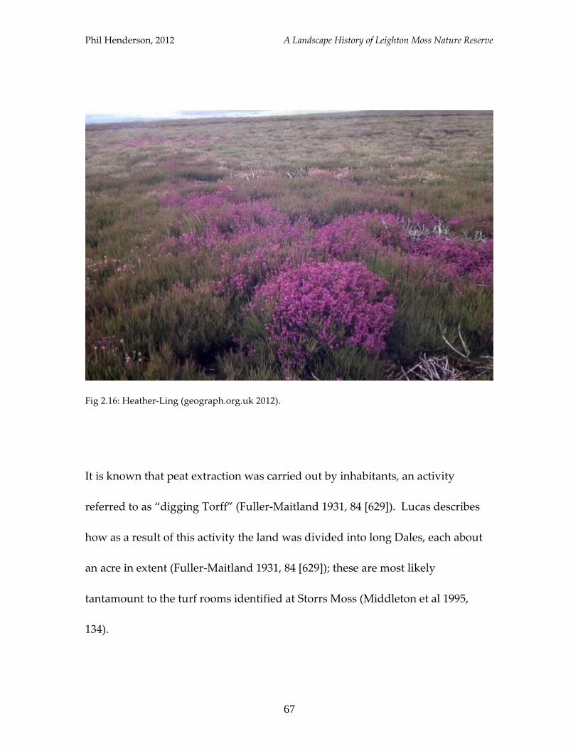
Phil Henderson, 2012 A Landscape History of Leighton Moss Nature Reserve
67
Fig 2.16: Heather-Ling (geograph.org.uk 2012).
It is known that peat extraction was carried out by inhabitants, an activity
referred to as “digging Torff” (Fuller-Maitland 1931, 84 [629]). Lucas describes
how as a result of this activity the land was divided into long Dales, each about
an acre in extent (Fuller-Maitland 1931, 84 [629]); these are most likely
tantamount to the turf rooms identified at Storrs Moss (Middleton et al 1995,
134).
Phil Henderson, 2012 A Landscape History of Leighton Moss Nature Reserve
68
Beyond the era covered by Lucas’ work, little is known about the disposition of
Leighton Moss, with snippets that do exist providing a more general picture of
the area. A piece of incidental information though, provided in a series of
footnotes, does allow something to be said about the site in the sixteenth century,
and resolves beyond doubt the earlier equation of Leighton Moss with Warton
Moss. The said footnotes are repeated below:
“[In 1530] inhabitants of Bolton [le Sands] claimed an ancient right to drive their
beasts over Lindeth Marsh to Yealand Conyers Moss, but in the year named
Robert and John Kitson, with others of Warton, to the number of a thousand,
resisted the passage with arms in their hands” (Farrer & Brownbill 1914, 161-5
[3]).
“Leighton Moss, otherwise Warton Moss, was claimed as part of the manor by the
inhabitants of Warton in 1532” (Farrer & Brownbill 1914, 161-5 [1]).
It thus appears that the Moss gained the prefix Warton around the year 1532,
after an altercation over grazing access; prior to this it was known as Yealand
Conyers Moss. The first quoted passage is particularly insightful, for it
profoundly illuminates a picture of sixteenth century Leighton Moss. It was a
valuable asset, and the allusion to an ancient right over its use suggests that it
may have been used for pasture prior to the 1530s. The fact that this right
belonged to inhabitants of Bolton-le-Sands also shows the importance of wider
Phil Henderson, 2012 A Landscape History of Leighton Moss Nature Reserve
69
landscape associations, with this settlement lying several miles to the south of
the site.
The Wider Landscape
For details of the form of the wider landscape in this period, Lucas is again the
champion of sources. He mentions land improvement through the removal of
stones (Fuller-Maitland 1931, 3 [25]), which most likely indicates an expansion of
the area under arable cultivation; the removal of stones facilitated the use of a
plough. The growth of “Oates, Barley and Pease” is noted as forming the
dominant crop of the Parish (Fuller-Maitland 1931, 4 [26-7]), while it is also
related that oxen were used for ploughing (Fuller-Maitland 1931, 44 [365]). It can
be ascertained that the landscape was fragmented in places by fences and
hedges, which had been incorporated as part of the creation of pre-Enclosure
enclosures (Fuller-Maitland 1931, 5 [31]), and that sycamores were present on the
grounds of the vicarage at Warton (Fuller-Maitland 1931, 27 [283]). The presence
of sycamore trees in the eighteenth century landscape is a detail of particular
resonance today, given that the contemporary view of them as an alien species
has led to their removal (see page 45).
Phil Henderson, 2012 A Landscape History of Leighton Moss Nature Reserve
70
The general impression given by Lucas is that the landscape was much wetter
during his lifetime. He describes large tracts of wetlands which must have
dominated the lower-lying districts: “[the] large Flat of Meadows and Mosses
now lying in Warton, Carnford [sic], Borwick and Caponwray” (Fuller-Maitland
1931, 28 [287]). That reeds were growing alongside the River Keer is mentioned,
a fact that suggests the water-level of the adjacent land must have been relatively
high in order to support them. While the existence of a tarn – “the Ware” – is
also noted as having been situated at the lower end of Warton (Fuller-Maitland
1931, 28 [287]); no such tarn exists today.
This rather soggy disposition led unsurprisingly to attempts at water
management; a point well illustrated by the following extract pertaining to
Carnforth:
“Between the inner and outward Marshes is a Ridge or Bank call’d the Strand,
raised from two Points of higher Ground, on purpose to preserve their Mosses
from being spoiled by the Spring Tides” (Fuller-Maitland 1931, 140 [885]).
A sluice system was also constructed on the Black-Dykes (situated on the
Carnforth side of the River Keer, near its mouth) to prevent salt-waters from
entering the Mosses, so as to protect “Turf Grounds” (Fuller-Maitland 1931, 140
Phil Henderson, 2012 A Landscape History of Leighton Moss Nature Reserve
71
[885]). Harnessing the power of water seems also to have altered the landscape
somewhat, with a “Groit” (artificial channel) being drawn from Leighton Beck in
order for the smelting of iron to take place (Fuller-Maitland 1931, 56 [464]).
The state of the salt-marsh during the period under discussion is also related.
Lucas states that at the beginning of the eighteenth century, the river Kent
diverted its course southward, and that combined with the violence of the tides,
common marshes and enclosed ground was destroyed (Fuller-Maitland 1931, 12
[65]). It is assumed that he is referring to the Silverdale salt-marsh, given its
proximity to the Kent-channel, but Lucas does not make this specific. In
subsequent discussion of this township, Lucas states: “The Salt Marshes bear a
short Grass which is very valuable for its Excellency in recovering, feeding and
preserving Sheep… [they also] abound in the choicest mushrooms…” (Fuller-
Maitland 1931, 49 [387]). Thus it may be the case that a period of accretion had
subsequently occurred, enabling the introduction of sheep to Silverdale marsh.
It is known that Silverdale Moss was used by some inhabitants for the retting of
hemp and flax, and that this Moss was also divided into dales, each
compartment referred to as a “Mossdale” by the Silverdale Manor Court (MLHS
1998, 145). Haweswater Moss was also being exploited at this time; the water

Phil Henderson, 2012 A Landscape History of Leighton Moss Nature Reserve
72
level was artificially lowered in the eighteenth century to facilitate peat
extraction (MLHS 2005, 22). The contemporary landscape is also littered with
physical traces of the charcoal and lime industries of this era, with pits, platforms
and kilns being strongly represented among sites and find listed by the
PastScape project (English Heritage, 2012). Physical traces of arable farming are
present in the form of ridge and furrow, listed again by the Pastscape project.
Evidence that land was under arable production in the Parish since at least the
sixteenth century is also made apparent by research undertaken by MLHS, from
which the following passage has been extracted:
“Mabell Saul. Widow of Thomas Saul.
One Tenement 1A and 1R of arrable land lying in a Close called Boodhams Close.
One Close lying at the North end of the said Tenement = 1A.
Close called Slackwood = 2A.
2 A of arrable lying in 7 pieces in the Common Field” (Thomas 1985, 13).
The passage appears to come from the Silverdale Manor Court, and is dated to
1563. In the sixteenth century, Silverdale Manor is said also to have held a
fishery, salt-cotes and iron-mines as part of its appurtenances (Farrer &
Brownbill 1914, 180-2).
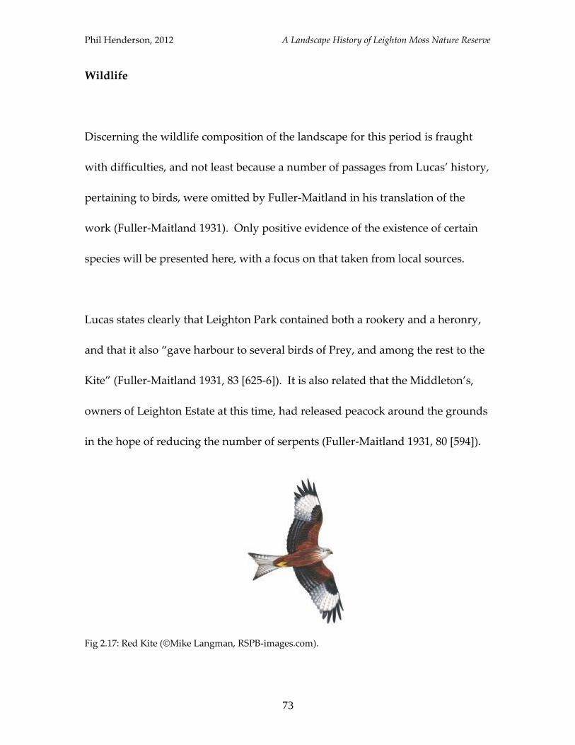
Phil Henderson, 2012 A Landscape History of Leighton Moss Nature Reserve
73
Wildlife
Discerning the wildlife composition of the landscape for this period is fraught
with difficulties, and not least because a number of passages from Lucas’ history,
pertaining to birds, were omitted by Fuller-Maitland in his translation of the
work (Fuller-Maitland 1931). Only positive evidence of the existence of certain
species will be presented here, with a focus on that taken from local sources.
Lucas states clearly that Leighton Park contained both a rookery and a heronry,
and that it also “gave harbour to several birds of Prey, and among the rest to the
Kite” (Fuller-Maitland 1931, 83 [625-6]). It is also related that the Middleton’s,
owners of Leighton Estate at this time, had released peacock around the grounds
in the hope of reducing the number of serpents (Fuller-Maitland 1931, 80 [594]).
Fig 2.17: Red Kite (©Mike Langman, RSPB-images.com).
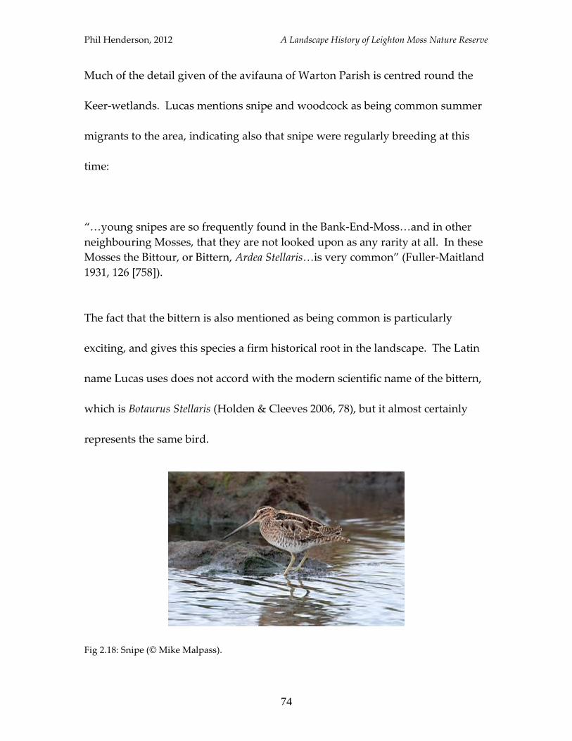
Phil Henderson, 2012 A Landscape History of Leighton Moss Nature Reserve
74
Much of the detail given of the avifauna of Warton Parish is centred round the
Keer-wetlands. Lucas mentions snipe and woodcock as being common summer
migrants to the area, indicating also that snipe were regularly breeding at this
time:
“…young snipes are so frequently found in the Bank-End-Moss…and in other
neighbouring Mosses, that they are not looked upon as any rarity at all. In these
Mosses the Bittour, or Bittern, Ardea Stellaris…is very common” (Fuller-Maitland
1931, 126 [758]).
The fact that the bittern is also mentioned as being common is particularly
exciting, and gives this species a firm historical root in the landscape. The Latin
name Lucas uses does not accord with the modern scientific name of the bittern,
which is Botaurus Stellaris (Holden & Cleeves 2006, 78), but it almost certainly
represents the same bird.
Fig 2.18: Snipe (© Mike Malpass).
Phil Henderson, 2012 A Landscape History of Leighton Moss Nature Reserve
75
It is related subsequently that the eggs of various birds were often found on the
inner marsh and neighbouring Mosses, with “those of the Lapwing or Tewet, the
Sea-Pye, and other Sea-fowls” being most common (Fuller-Maitland 1931, 141
[886]). Sea-Pye is an obscure name, but is fortunately listed by Holden & Cleeves
as a local name for the oystercatcher (2006, 295). The lapwing is of course a
familiar bird to this study, but it is interesting to note the alternative name given
for it above: tewet. This is no doubt derived from the birds’ call, with peewit
being the modern, alternate name for the lapwing for this reason. Now the
association of the lapwing with the area has already been shown to run-deep,
appearing as it does in each chapter, but it could be postulated that its connection
to the landscape is stronger still: Tewitfield, situated north-east of Warton, just
above Pine Lakes (see Fig 2.2), could surely have been named after the “tewet”.
It existed as a named place in Lucas’ day just as it does in the present.
The names of other landscape features that appear to remember an animal
species include “Partridge Hills” and “Polecat-well” (Fuller-Maitland 1931, 125
[747] and 132 [839]). Whether both species were present at the time of writing
would need further substantiation, though Lucas does expressly say that
Partridge Hills “had their name from that fowl” (Fuller-Maitland 1931, 125 [747]).
The Church Wardens’ Accounts for Warton Parish are not particularly helpful in
Phil Henderson, 2012 A Landscape History of Leighton Moss Nature Reserve
76
relating the wildlife composition of the locality, as while they do record vermin
payments for rook, raven and foxes, they are equally as concerned with
purchasing of flax and parchment, bread and wine, and the repair of the church-
clock (LRO, Church Wardens’ Accounts 1739-1865). The Wardens’ accounts
from Beetham Parish, adjoining Warton Parish to the north, do tell that the wild-
cat and pine-marten were present in the late seventeenth century (Lovelock
2007), and so it is possible that some individuals may have resided in Warton
Parish at this time. The wild-cat specifically is last recorded from Burton-in-
Kendal in 1759 (Lovelock 2007, 226).
A sample of the wildlife composition has thus been provided, to which conies at
Barrow Scout (Fuller-Maitland 1931, 40 [354]) and otter in the River Keer (Fuller-
Maitland 1931, 122 [725]) may also be added. Given that Leighton Moss had
taken the form of a raised bog during this period, it could also be suggested that
skylark and meadow pipit were in attendance, being as they are the most
characteristic bird species of this habitat-type today (Fuller 1982, 148). The land-
uses discussed above, such as peat-cutting may also have acted to alter the
vegetation composition of parts of the Moss surface, perhaps providing
opportunities to a larger array of species (Fuller 1982, 150).
Phil Henderson, 2012 A Landscape History of Leighton Moss Nature Reserve
77
Summary
This chapter has followed the history of Leighton (or Warton) Moss from the
mid-eighteenth century to the mid-sixteenth, during which time evidence
suggests it had taken the form of a raised bog. The dominant vegetation of the
Moss has been shown to have been heather ling, with the surrounding landscape
offering a diverse range of habitats to wildlife. Overall, the landscape of this era
was much wetter than that of the nineteenth century, with expanses of meadows
and mosses, especially between Warton and Carnforth, supporting species such
as lapwing, snipe and bittern.
Phil Henderson, 2012 A Landscape History of Leighton Moss Nature Reserve
78
5
Medieval and Beyond
The history of Leighton Moss beyond the sixteenth century is difficult to recount
with any degree of intricacy. References to the site are non-existent, but glimpses
of information are provided from the medieval period up to prehistory that infer
the predominance of a wetland landscape. This chapter will provide those
glimpses, and attempt to give some indication as to the wildlife composition
attending them.
What follows will be divided in two parts. The first will examine evidence
pertaining to the medieval period, and that extending beyond it to the ninth
century. The second will encompass the “pre-ninth century” – the relatively
huge expanse of time from the ninth century up unto the late Mesolithic age.
This split is due largely to the nature of the evidence, with slightly larger
glimpses being afforded for the first part.
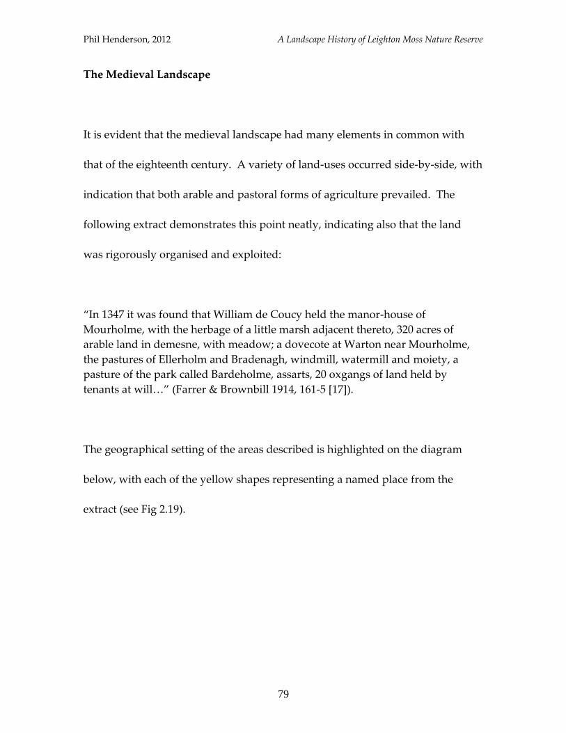
Phil Henderson, 2012 A Landscape History of Leighton Moss Nature Reserve
79
The Medieval Landscape
It is evident that the medieval landscape had many elements in common with
that of the eighteenth century. A variety of land-uses occurred side-by-side, with
indication that both arable and pastoral forms of agriculture prevailed. The
following extract demonstrates this point neatly, indicating also that the land
was rigorously organised and exploited:
“In 1347 it was found that William de Coucy held the manor-house of
Mourholme, with the herbage of a little marsh adjacent thereto, 320 acres of
arable land in demesne, with meadow; a dovecote at Warton near Mourholme,
the pastures of Ellerholm and Bradenagh, windmill, watermill and moiety, a
pasture of the park called Bardeholme, assarts, 20 oxgangs of land held by
tenants at will…” (Farrer & Brownbill 1914, 161-5 [17]).
The geographical setting of the areas described is highlighted on the diagram
below, with each of the yellow shapes representing a named place from the
extract (see Fig 2.19).
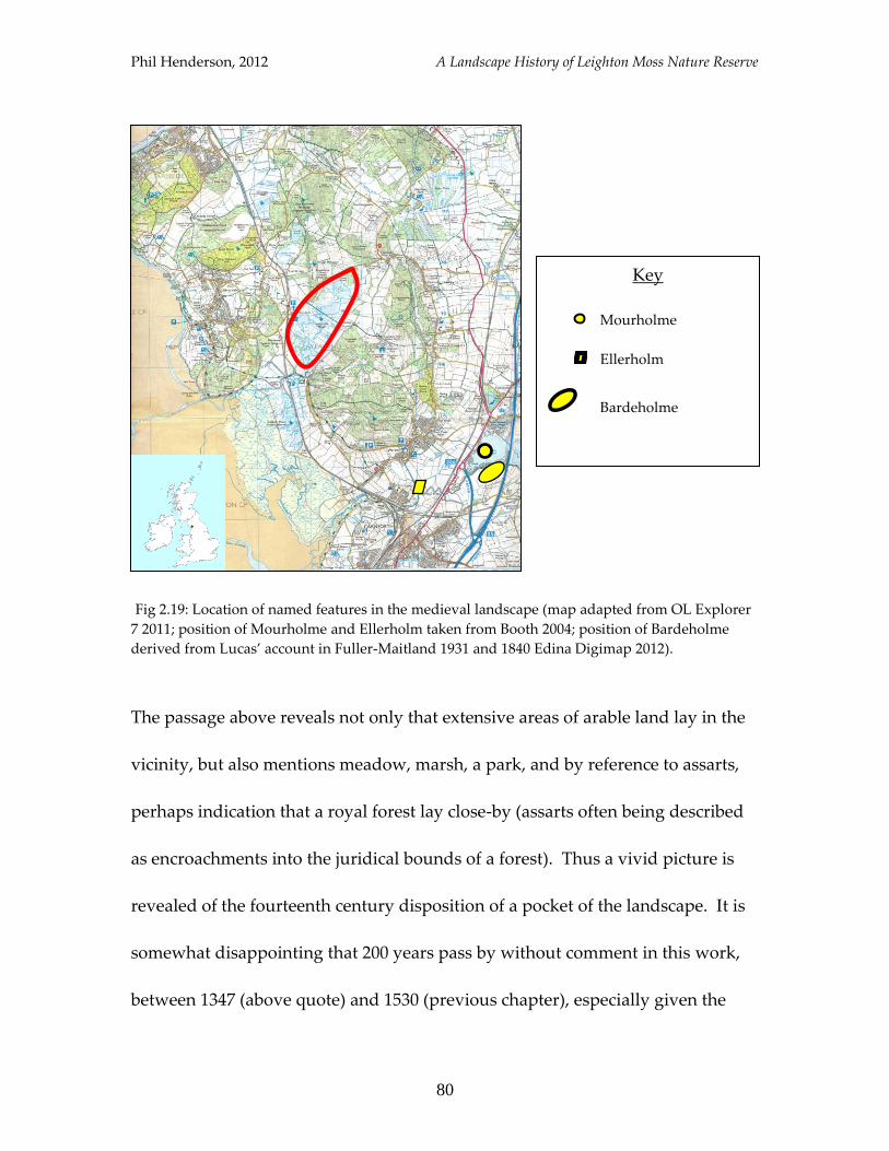
Phil Henderson, 2012 A Landscape History of Leighton Moss Nature Reserve
80
Fig 2.19: Location of named features in the medieval landscape (map adapted from OL Explorer
7 2011; position of Mourholme and Ellerholm taken from Booth 2004; position of Bardeholme
derived from Lucas’ account in Fuller-Maitland 1931 and 1840 Edina Digimap 2012).
The passage above reveals not only that extensive areas of arable land lay in the
vicinity, but also mentions meadow, marsh, a park, and by reference to assarts,
perhaps indication that a royal forest lay close-by (assarts often being described
as encroachments into the juridical bounds of a forest). Thus a vivid picture is
revealed of the fourteenth century disposition of a pocket of the landscape. It is
somewhat disappointing that 200 years pass by without comment in this work,
between 1347 (above quote) and 1530 (previous chapter), especially given the
Key
Mourholme
Ellerholm
Bardeholme
Phil Henderson, 2012 A Landscape History of Leighton Moss Nature Reserve
81
particularly tumultuous ramifications of the Black Death which will have been
made manifest in this void. The remains of a deserted medieval village (DMV) at
Yealand Storrs may owe something to this interlude, though this supposition is
not possible to prove. Both Ford (1931, 25) and the PastScape project (English
Heritage 2012) record the Yealand Storrs DMV, but neither can attribute more
than an approximate date to it.
It is known that following English defeat at Bannockburn, the Scots raided
Lancashire in 1322, visiting much damage around Carnforth and Warton (Booth
2004). Booth notes that the Inquisition Post Mortem of a local inhabitant, dated
to 1324, records the fact that cattle were taken and houses and gardens burned by
the assailants (Booth 2004, 11). These settlements may have been targeted owing
to their high status, with Warton having been elevated to the rank of a borough
in the mid-thirteenth century (Booth 2004, 5). The fact that Lancaster and Preston
were destroyed by the Scots during this particular series of raids may add further
credence to this suggestion.
The borough charter, which was granted to Warton sometime between 1246 and
1271 (Booth 2004, 5), provides further fascinating insight into the medieval
Phil Henderson, 2012 A Landscape History of Leighton Moss Nature Reserve
82
landscape around Leighton Moss. The charter demarcates the lands which are
not to be included within the borough (Booth 2004, 5), and reads:
“The wood of Staynhusslac bounded by the ditch which comes from Lindeth to
Warton on the west side, and as far as the wood goes towards Barraht. The
wood and pasture of Ellerholm (within the ditch) with its appurtenances. The
park of Mourholme by the bounds fixed on the day of making this charter. The
pasture of Southou, from Southou by the sea-dyke up to Quytesandpole and to
Quitsandpole from the side up to Lindeth and from Lindeth, the whole area of
enclosed land up to Blackdyke, and going up Blackdyke to the crag beyond
Blackwell, and so from the crag to Southou” (quoted in Booth 2004, 5).
Now even just for the land-features it relates this charter is immensely valuable,
alluding to the existence of wood, a ditch, pasture, a park, a sea-dyke and
enclosed land. The mention of a sea-dyke is of particular significance, especially
given its position which by inference must have been close to Quicksand Pool in
the modern landscape; directly south-west of Leighton Moss. The sea-dyke was
presumably built as a means of protecting the land behind it, suggesting
Leighton Moss was a valuable asset in the thirteenth century. Attempting to
locate the areas outlined by the charter has not been entirely possible in this
work, with not enough named features being readily identifiable even with
assistance from historic maps and Lucas’ account. Below is Booth’s attempt to
map-out the landscape according to the charter:
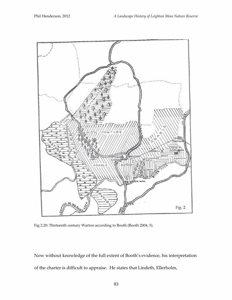
Phil Henderson, 2012 A Landscape History of Leighton Moss Nature Reserve
83
Fig 2.20: Thirteenth century Warton according to Booth (Booth 2004, 5).
Now without knowledge of the full extent of Booth’s evidence, his interpretation
of the charter is difficult to appraise. He states that Lindeth, Ellerholm,
Phil Henderson, 2012 A Landscape History of Leighton Moss Nature Reserve
84
Quicksand Pool and Black Dyke have modern equivalents (though he does not
locate Black Dyke on his diagram), but admits that the positions of Staynhusslac
wood, Barraht and Southou are educated guesses (Booth 2004, 5-6). Perhaps
Staynhusslac wood could be better equated with the modern Slackwood, which
Mabell Saul was shown above to have held in 1563, but it is difficult to
substantiate this claim further. One point to make though is that the named
features do not necessarily have to have formed one coherent block of land, as
Booth represents above, but instead could have been separate fragments of
private ground dotted about the landscape.
At the turn of the thirteenth century, a grant of 20 acres of land in Yealand was
made by a “Henry son of Herman” (LRO, c.1200 grant), and one would assume
that it was this same Henry, Henry de Redmayne, who granted Haweswater to
Cartmel during the reign of King John (Farrer & Brownbill 1914, 180-2 [1]).
These snippets of information imbue the sense that human presence in the
landscape was strong at this time, but as aforementioned, the nature of Leighton
Moss remains a mystery for this period. The Domesday Book, which is
frequently quoted when researching the early history of places, sheds no light on
the configuration of the physical landscape, detailing only its ownership (Farrer
& Brownbill 1914). Indeed, as Terrett asserts, very little information is held for
Phil Henderson, 2012 A Landscape History of Leighton Moss Nature Reserve
85
Lancashire north of the Ribble (Terrett 1962, 397), thus very little can be said
about the disposition of the area beyond the early thirteenth century.
The origins of the names of proximate settlements are noteworthy though, and
may tell something of the landscape in which they were coined. “Mourholme”
for instance, is thought to mean “island in the marsh” (Clarke 1982, 3), which
would accord with the earlier supposition that the medieval landscape was a wet
one. The derivation of “Carnforth” supports this claim, being “crane-ford”
(Yalden & Albarella 2009, 116); the crane being of course a bird associated with
wetlands. The origin of “Yealand” is also interesting; thought to mean “land
newly taken under cultivation” and dated to the late Saxon-period (Gelling 2007,
28-34), it could give some idea as to when the area was being settled.
The Landscape Beyond
The earliest evidence for the disposition of the Leighton Moss landscape is
disparate to say the least. Various sites and finds have been identified and
logged by the PastScape survey (English Heritage 2012), yet a comprehensive
picture is difficult to create. This is perhaps due in the early first millennium to a
period of marine transgression, which Gardiner asserts effectively left coastal
Phil Henderson, 2012 A Landscape History of Leighton Moss Nature Reserve
86
wetlands a clean-slate for medieval settlers (Gardiner 2008, 300). A suspected
Roman wharf site is recorded by the PastScape survey as having been located
near to modern-day Pine Lake (English Heritage 2012). This could indicate that
sea-level was much higher in the locality in the early first millennium - to
facilitate a functioning wharf the site of which now lies approximately three
kilometres inland - or simply that the river Keer had much the same position as it
does today, and that the wharf was accommodated by the river.
Warton crag and Dog Holes cave are well-known Iron Age sites, with the latter
containing evidence that alludes to both arable and pastoral forms of agriculture
taking place in the neighbouring area. Jackson, who excavated the cave in the
early twentieth century, related that a small iron sickle was discovered, and came
to the conclusion it will have been used for harvesting crops (Jackson 2007, 128).
Sheep, goat and domestic pig were also amongst the livestock represented
during excavations spanning 1907-12 (Jackson 2007, 129).
Palaeoenvironmental work has been undertaken in the vicinity of the reserve,
with that at Storrs Moss (Powell et al 1971) and Little Haweswater (Taylor et al
1994) representing the most local to Leighton Moss. Both investigations used
coring to extract pollen samples, with subsequent analysis of these cores
Phil Henderson, 2012 A Landscape History of Leighton Moss Nature Reserve
87
allowing inference to be made about local vegetation composition and
environmental conditions, as well as levels of human interaction. Pollen samples
were representative of the Neolithic period and beyond, with peat layers above
those pertaining to this era being too badly damaged by peat extraction to allow
analysis (Taylor et al 1994).
At Storrs Moss, the conclusion of research was that in the late Mesolithic/early
Neolithic period, the site was covered by a carr-forest transition zone, within
which some utilization of wood-resources was taking place (Powell et al 1971,
135). It is thought that closed forest conditions prevailed in the surrounding area
(Powell at al 1971, 131), with wood samples dominated by alder; oak, willow,
Scots pine and alder buckthorn were also represented in the pollen samples
taken (Powell et al 1971, 129). At Little Haweswater, a similar conclusion was
reached, with evidence of minimal human activity occurring at the transition
zone between forest and open ground (Taylor et al 1994).
Phil Henderson, 2012 A Landscape History of Leighton Moss Nature Reserve
88
Wildlife
Much of what can be related of the wildlife composition of the area for the
medieval period and beyond is subject to supposition, but some comments can
be made. Place-name evidence has been used extensively to mark the presence
of an animal species in a given locality, with Yalden supporting this method,
asserting that often they make ecological sense (Yalden & Albarella 2009, 120).
He notes for instance that cranes are most often combined with springs or
marshes, while eagles and ravens are associated with cliffs and dales (Yalden &
Albarella 2009, 120-1). Thus “Carnforth” could have emerged from a wetland
landscape, to which cranes were linked. The name is thought to date to the
Saxon period (Yalden & Albarella 2009, 115), and cranes are believed to have
been fairly widespread in early medieval England, becoming extinct as a
breeding species in the seventeenth century (Yalden & Albarella 2009, 144). An
individual bird was seen at Leighton Moss in 1977 (Wilson et al 1988, 73).
It cannot be said whether cranes were a common sight or a relative rarity, but
one pertinent question is why, when many species must have been present in the
landscape, would one accord greater significance than another? There is no
space here to provide a rigorous debate, but it is worth noting that when trying
Phil Henderson, 2012 A Landscape History of Leighton Moss Nature Reserve
89
to discern the composition of fauna as opposed to the presence of a single species,
place-name studies may actually act to obscure the wildlife make-up. In the song
“the riddle”, Nik Kershaw provides an apt line that can be related to this topic:
“blackbird sings on bluebird hill” (Kershaw 1984); the relation of a place to a
species may mask the presence of other species thereabout. What other species
may have been singing at crane-ford?
The archaeological record of birds could provide answers to this question,
though avifaunal remains were not identified in any of the major archaeological
investigations mentioned above. Only at Manor Farm in Borwick, which lies less
than half-a-kilometre east of Pine Lake, have bird-bones been recorded.
Excavation here of a two-phase ring cairn, dated to the Bronze Age, revealed
“mallard, plovers, woodcock, thrush (including song), finch and wren” (Huntley
& Stallibrass 1995, 115). It is fascinating that all of these species inhabit the area
today, providing a direct link between the sights and sounds experienced
perhaps three thousand years ago. Indeed, Yalden and Albarella suggest that
even as far back as the Neolithic period, the birds present would have been much
as might be expected in the same locations today (2009, 78).
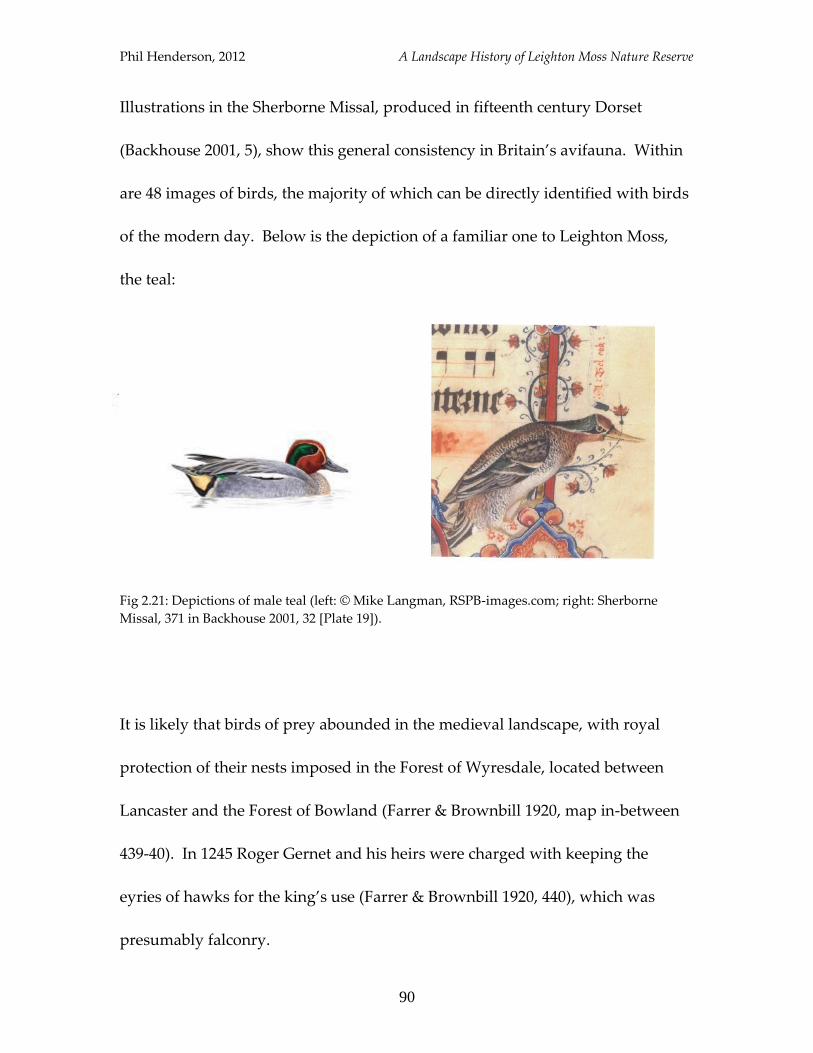
Phil Henderson, 2012 A Landscape History of Leighton Moss Nature Reserve
90
Illustrations in the Sherborne Missal, produced in fifteenth century Dorset
(Backhouse 2001, 5), show this general consistency in Britain’s avifauna. Within
are 48 images of birds, the majority of which can be directly identified with birds
of the modern day. Below is the depiction of a familiar one to Leighton Moss,
the teal:
Fig 2.21: Depictions of male teal (left: © Mike Langman, RSPB-images.com; right: Sherborne
Missal, 371 in Backhouse 2001, 32 [Plate 19]).
It is likely that birds of prey abounded in the medieval landscape, with royal
protection of their nests imposed in the Forest of Wyresdale, located between
Lancaster and the Forest of Bowland (Farrer & Brownbill 1920, map in-between
439-40). In 1245 Roger Gernet and his heirs were charged with keeping the
eyries of hawks for the king’s use (Farrer & Brownbill 1920, 440), which was
presumably falconry.
Phil Henderson, 2012 A Landscape History of Leighton Moss Nature Reserve
91
Wolves may have been a feature of the wider landscape in the thirteenth century,
with Yalden relating that “…in the Royal Forest of Lancaster, a man was paid 1S
2d to guard the calves against the wolves in 1295-6, while seven calves were
killed that year and a further eight cattle were killed by them 1304-5” (1999, 168).
Wolf remains were also identified during excavations at Dog Holes cave, and
were attributed a Romano-British date (Jackson 2007, 129). Bones of fox, badger,
common hare and fallow deer were also recorded as being contemporary to the
wolf.
The beaver may have been present north of the study site at Barbon; the name
being taken to mean “beaver-stream” (Coles 2006, 144). That “Barbon” is likely
to derive from Old Norse (Coles 2006, 144) may also provide indication as to
when beavers were present to bestow the name. Norsemen are known to have
settled north-west England in the ninth century (Peter 1987, 18), giving a likely
earliest date for the designation of Barbon. A likely latest date for the origin of
the name may be placed before 934, after which point the Saxon king Athelstan
became the dominant political force in the region (Fellows-Jensen 2007, 18-27),
and thus place-names coined after this date are unlikely to have been Norse.
Beavers may thus have been a feature of the wider landscape around 900AD.
Phil Henderson, 2012 A Landscape History of Leighton Moss Nature Reserve
92
Summary
This chapter has revealed glimpses of the landscape around Leighton Moss from
the medieval period to prehistory. These glimpses are somewhat larger for the
medieval period, and when combined with detail provided in previous chapters,
insinuate that lower lying reaches were probably at least seasonal wetlands, with
marshes, and islands in them – Mourholme – mentioned. The existence of a
thirteenth century sea-dyke was also related, which tells that water management
was being undertaken, and again suggests the predominance of a wetland
landscape; presumably it was constructed to combat tidal inundation. That
arable and pastoral agriculture was also undertaken has been evidenced, and the
sea-dyke was likely built to protect the longevity of these valuable areas.
Wildlife composition has been largely determined by educated guesswork, with
place-name evidence used to suggest the presence of cranes and beavers in the
wider landscape. Archaeological and documentary evidence suggests that the
wolf may have been in attendance as late as the thirteenth century, and
excavations dating to the Bronze Age at Borwick have been summarised to show
that birds prevalent three thousand years ago would be familiar features of the
modern day landscape around Leighton Moss.

Phil Henderson, 2012 A Landscape History of Leighton Moss Nature Reserve
93
3
Analysis and Discussion
Phil Henderson, 2012 A Landscape History of Leighton Moss Nature Reserve
94
1
What Made Leighton Moss?
Having presented the “what” and “when” of landscape disposition in the
historical narrative of Leighton Moss, this section will examine the “how” and
“why then” of changes highlighted. Key underlying processes – mechanisms
and management – that have led to the current landscape configuration and
wildlife composition will be identified. Focus will be placed on understanding
and explaining the three most recent phases of landscape form; that is, on
developments since the early eighteenth century. Beyond this period the
evidence unearthed is not conducive to detailed analysis. Suggestions will
though be made as to the reasons behind the timing of modifications, with some
allusion to earlier periods.
Phil Henderson, 2012 A Landscape History of Leighton Moss Nature Reserve
95
Initially, the setting will be provided by looking at the origins of the land and the
effects of tidal inundation of it. It will be related that changes in relative sea-level
formed Leighton Moss, in the truest sense, and that throughout its history water
has been the dominant element in landscape change. Water depth, chemistry
and the frequency of fluctuations in both, largely determine vegetation
composition (Van der Valk 2006), thereby influencing how the land looks, and
what can be seen in it. Human-management of water will be shown to have had
the most recent, profound effect on land-form and function.
Phil Henderson, 2012 A Landscape History of Leighton Moss Nature Reserve
96
Forming the land
Leighton Moss started-out as a flooded embayment of Morecambe Bay
(Middleton et al 1995, 134). Its origins could therefore be attributed to either a
rise in sea-level, which will have begun the process of alluvial deposition in the
basin (see Fig 1.2); or a fall in sea-level, which will have revealed a new land
surface. Sea-level changes in Morecambe Bay have been studied by Zong and
Tooley (1996), who assert that relative sea-level in the area rose between 6510BC
and 1500BC, with fluctuations at rates between −8mmyr⁻¹ and +12mmyr⁻¹ (Zong
& Tooley 1996, 55). They also relate that after 1500BC, fluctuations in relative
sea-level are likely to have stabilised, with rises and falls probably occurring
within ±2mmyr⁻¹ (Zong and Tooley 1996, 55). This would suggest that while the
land surface of Leighton Moss could have been unveiled earlier, it is likely that
prolonged exposure will not have occurred until around 1500BC.
Fluctuations in relative sea-level can therefore be posited as having had a major
impact upon the landscape, effectively producing the land surface on which
Leighton Moss sits today. Aside from significant changes in sea-level, periods of
tidal inundation also appear to have influenced the configuration of the
landscape, and perhaps posthumous interpretation of it. An episode of marine
Phil Henderson, 2012 A Landscape History of Leighton Moss Nature Reserve
97
transgression is thought to have occurred in the early first millennium (Gardiner
2008, 299; Simmons 2001, 70; Coles 2006, 6), which Gardiner asserts will have
effectively erased the wetland landscapes that preceded inundation, covering
them with sediment (Gardiner 2008, 299). The extent to which this claim is
applicable to Leighton Moss though is difficult to ascertain; Gardiner is speaking
of evidence pertaining to Romney Marsh in Kent, and the consulted evidence in
this work does not allow for detailed comment. It is clear however, from the
construction of sea defences in the medieval period, and seasonal flooding of the
Moss noted in the nineteenth century, that inundation has a legacy of influence
in the vicinity.
The physical conditions imposed by cycles of inundation would of course limit
the colonization potential of the land to vegetation, favouring species with
resilience to it. In the case of Leighton Moss, it is known that following the initial
fall in sea-level, the exposed “[silty] clay was colonised by a phragmites -
dominated reed bed” (Middleton et al 1995, 134). Relatively stable conditions
seem then to have allowed natural succession to take place, with the subsequent
development of a fen, and then a fen-carr (Middleton et al 1995, 134). The plants
themselves act to alter the immediate landscape through annual growth-cycles,
which in the case of reeds involve the dying back of the plant in winter, and the
Phil Henderson, 2012 A Landscape History of Leighton Moss Nature Reserve
98
deposition of litter. Over a number of years a build-up of litter will occur, and if
left un-interrupted, will begin to dry-out the reed-bed through raising the level
of the substrate. Species such as willow can then begin to colonise, accelerating
the progression from reed-bed to a new phase of succession.
It is thus apparent that in providing base conditions for a select group of plants,
tidal cycles have been instrumental to landscape form. The growth cycles of the
plants themselves have been shown to have their own impact, but this is subject
to prevalent physical conditions, as well as exploitation by humans and animals.
Mowing of tall reeds is mentioned by Rieley and Page as an action that prevents
succession (1990, 92); presumably grazing by livestock would have a similar
effect. One ramification of Leighton Moss having been a wetland for much of its
discernable history has also influenced subsequent interaction with humans: the
growth of vegetation on waterlogged soils provides ideal conditions for the
formation of peat (Fuller 1982, 147). As will be related below, this ready source
of fuel is likely to be a key reason Leighton Moss was not “improved” until the
end of the eighteenth century.
Phil Henderson, 2012 A Landscape History of Leighton Moss Nature Reserve
99
Fashioning the land: raised bog to arable farmland
Between the mid-eighteenth and early nineteenth century, Leighton Moss was
transformed from a raised bog to arable farmland. This change was achieved in
part by reducing the amount of water entering the Moss, through drainage dykes
to intercept freshwater run-off, and sluice systems to reduce the incidence of
tidal inundation. Embankments were also constructed at the seaward end of the
Moss to further reduce the risk of flooding. The removal of water from the
saturated peat-soils was also undertaken through the installation of two coal-
powered pumps. In tandem, these management techniques made the land
suitable for the sowing of arable crops.
It is likely that the dehydrated Moss surface will have been altered directly by
processes of “paring and burning”, which involved setting fire to the peat; a
technique employed during conversion of the Yealand mosses around the same
time (MLHS 2005, 23). Burning will presumably have had the added benefit of
returning nutrients to the soil, thus further facilitating crop growth. The fact that
Leighton Moss was formed of alluvial deposits makes it likely that the substrate
already had a high level of fertility.
Phil Henderson, 2012 A Landscape History of Leighton Moss Nature Reserve
100
There are a number of reasons that can be posited for the timing of the alterations
described above. First of all, for much of the eighteenth century Leighton Moss
was a useful source of fuel, “Torff”, for the areas’ inhabitants. It seems this had
been the case since at least the medieval period (MLHS 2005, 25), and so there
was little positive incentive to damage this useful resource. On the flip-side, a
negative incentive to landscape-investment prior to the period of improvement
seems to have been the geo-political position of Leighton Moss, lying close to the
Anglo-Scottish border. As Newman asserts, although north Lancashire only
suffered raids twice in the fourteenth century, the threat is likely to have
dissuaded intensive development (Newman 1996). It is also possible, in an
uncertain environment, that the Moss could have provided a buffer to enemy
advance, and a refuge from it.
Demographic changes could also have applied pressure to increase agricultural
productivity, with rises in Parish population coinciding with the conversion of
Leighton Moss (see Table 3.1).
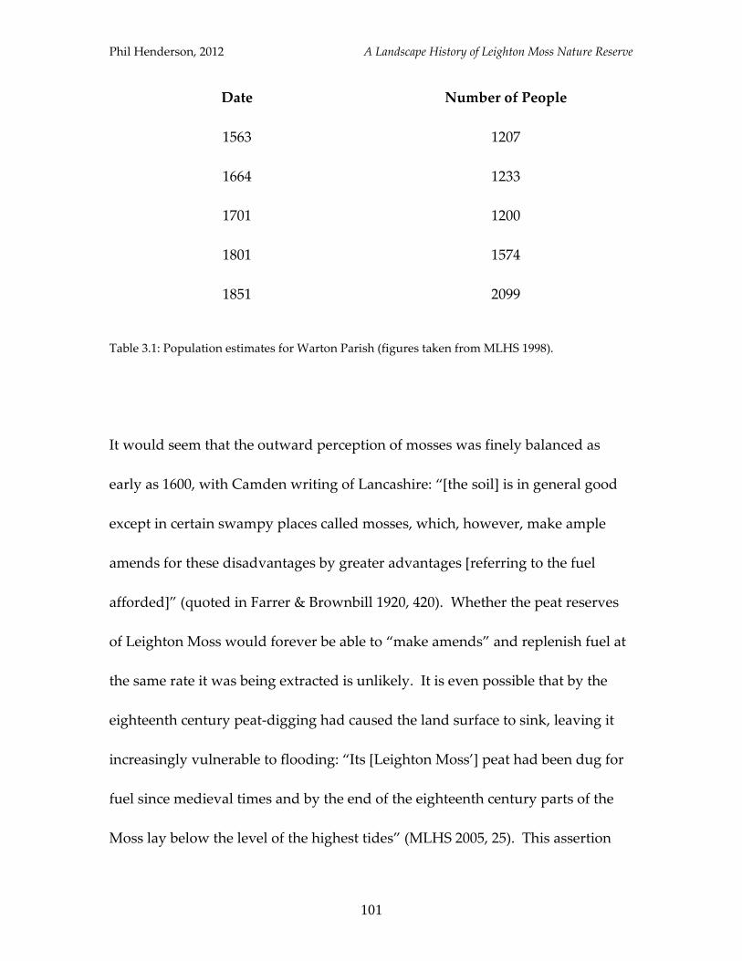
Phil Henderson, 2012 A Landscape History of Leighton Moss Nature Reserve
101
Date Number of People
1563 1207
1664 1233
1701 1200
1801 1574
1851 2099
Table 3.1: Population estimates for Warton Parish (figures taken from MLHS 1998).
It would seem that the outward perception of mosses was finely balanced as
early as 1600, with Camden writing of Lancashire: “[the soil] is in general good
except in certain swampy places called mosses, which, however, make ample
amends for these disadvantages by greater advantages [referring to the fuel
afforded]” (quoted in Farrer & Brownbill 1920, 420). Whether the peat reserves
of Leighton Moss would forever be able to “make amends” and replenish fuel at
the same rate it was being extracted is unlikely. It is even possible that by the
eighteenth century peat-digging had caused the land surface to sink, leaving it
increasingly vulnerable to flooding: “Its [Leighton Moss’] peat had been dug for
fuel since medieval times and by the end of the eighteenth century parts of the
Moss lay below the level of the highest tides” (MLHS 2005, 25). This assertion
Phil Henderson, 2012 A Landscape History of Leighton Moss Nature Reserve
102
may be reading too much into the quote, but it would serve to consider the
prolonged impact of peat extraction on a raised bog. Over time the formation of
peat causes the surface of the bog to “rise” above its original level; persistent
removal of peat would presumably cause it to fall-back. If this was the scenario,
it is likely that the Moss would lose its viability as a fuel source, and therefore
become more prone to calls for improvement.
These calls for improvement, embodied in Acts of Enclosure, will also have
created an air of change; this, combined with technical advancements in water
management and the various other factors mentioned above, will have
contributed to the transformation of Leighton Moss to arable farmland.
Fashioning the land: arable farmland to freshwater wetland
After a century of producing arable crops, Leighton Moss was covered by a
shallow lake, and subsequently colonised by a phragmites-dominated reed-bed.
The lake was formed as a result of the water-pumps charged with drainage
ceasing to operate in 1918/9, allowing freshwater from the surrounding area to
collect in the basin. The embankments constructed to prevent tidal incursion
Phil Henderson, 2012 A Landscape History of Leighton Moss Nature Reserve
103
remained intact, and so the Moss had the beginnings of a solely freshwater
wetland. It is uncertain, given the propensity of tidal-flooding throughout its
history, whether Leighton Moss had ever been a freshwater wetland before the
early twenty-first century.
The shallow lake was quickly colonised by phragmites, owing to the physical
conditions this state provided. Natural succession of vegetation appears to have
gone un-interrupted until the acquisition of the site by the RSPB in 1964, from
whence management commenced to halt and reverse this process. Rotational
reed-cutting was begun, and was carried out annually to prevent further drying-
out of the reed-bed. The area of open water was expanded through the use of
dredging machines, and water management infrastructure such as drainage
dykes and sluices were revitalised. Such infrastructure allowed for efficient
control of water levels at Leighton Moss (Fig 3.1), and thereby, over time, to the
configuration of the landscape observed today.

Phil Henderson, 2012 A Landscape History of Leighton Moss Nature Reserve
104
Fig 3.1: RSPB water management at Leighton Moss (RSPB Leighton Moss).
The timing of the change in state between arable farmland and freshwater
wetland can be explained by a number of factors. The flooding of Leighton Moss
coincided with the end of World War I; coal prices had risen sharply during the
war (Wilson et al 1988, 23), and so the monetary cost of arable production
through pumping of the Moss had increased. It is possible that this increase in
capital investment was not being met with an increase in yield, given that tidal
floods were still occurring as late as 1907 (Ford 1931, 29). Events such as this
Phil Henderson, 2012 A Landscape History of Leighton Moss Nature Reserve
105
would have damaged crops and perhaps raised questions over continued
drainage efforts.
It also happened that the flooding of the Moss increased the numbers and species
of birds inhabiting it that were sought for sport, occasioning a land-use that
required little investment of labour or finances: wildfowling. The lucrative
exploitation of birds in the 1920s, as evidenced by the Leighton Estate Game
Book (see page 42), suggests that there was no economic incentive for the land-
owners to revert the wetland back to a state of arable production. Wildfowling
though was a short-lived land-use, due largely to rapid colonization by
phragmites. The obstruction caused by dense-reed growth occasioned Leighton
Moss to be leased to the RSPB in 1964, and owing to the allure of the site to a
diverse range of species, and the financial support provided by growing
membership of the organization, the site was purchased in 1974.
This growing membership of the organization – from 20,000 in 1964 (Wilson et al
1988, 3) to over a million today – reflects a change in attitudes towards flora and
fauna, which has undoubtedly affected land use and thereby, landscape form.
Legislation, such as the Wildlife and Countryside Act (1981), can be posited as a
reason for this change in attitude, through influencing moral stance (Carman
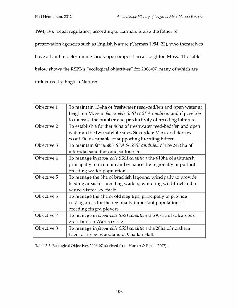
Phil Henderson, 2012 A Landscape History of Leighton Moss Nature Reserve
106
1994, 19). Legal regulation, according to Carman, is also the father of
preservation agencies such as English Nature (Carman 1994, 23), who themselves
have a hand in determining landscape composition at Leighton Moss. The table
below shows the RSPB’s “ecological objectives” for 2006/07, many of which are
influenced by English Nature:
Objective 1 To maintain 134ha of freshwater reed-bed/fen and open water at
Leighton Moss in favourable SSSI & SPA condition and if possible
to increase the number and productivity of breeding bitterns.
Objective 2 To establish a further 46ha of freshwater reed-bed/fen and open
water on the two satellite sites, Silverdale Moss and Barrow
Scout Fields capable of supporting breeding bittern.
Objective 3 To maintain favourable SPA & SSSI condition of the 2476ha of
intertidal sand flats and saltmarsh.
Objective 4 To manage in favourable SSSI condition the 610ha of saltmarsh,
principally to maintain and enhance the regionally important
breeding wader populations.
Objective 5 To manage the 8ha of brackish lagoons, principally to provide
feeding areas for breeding waders, wintering wild-fowl and a
varied visitor spectacle.
Objective 6 To manage the 4ha of old slag tips, principally to provide
nesting areas for the regionally important population of
breeding ringed plovers.
Objective 7 To manage in favourable SSSI condition the 9.7ha of calcareous
grassland on Warton Crag.
Objective 8 To manage in favourable SSSI condition the 28ha of northern
hazel-ash-yew woodland at Challan Hall.
Table 3.2: Ecological Objectives 2006-07 (derived from Horner & Birnie 2007).
Phil Henderson, 2012 A Landscape History of Leighton Moss Nature Reserve
107
Summary
A multitude of factors can be said to have “made” Leighton Moss; above focus
has been placed on discerning dominant land-forming processes, and the most
recent land-fashioning processes. It has been shown that changes in relative sea-
level are behind the physical formation of the land on which Leighton Moss sits,
through the deposition of silt and its subsequent exposure. The interplay
between tidal inundation and vegetation succession has been important
throughout the history of Leighton Moss, allowing different habitat conditions to
prevail for humans and wildlife alike. The growth of plants on waterlogged soil
created ideal conditions for the formation of peat, which was a feature of huge
significance for the subsequent development of the land surface through peat
extraction.
The degree of “wetness” at any given time can be said to have been vitally
important to landscape disposition, affecting at once how the land looked, how it
was used and perceived, and what could be seen in it. The influences of the
human social sphere have had, and continue to have, key impacts on current
landscape configuration, often determining human interaction with wetlands. In
Phil Henderson, 2012 A Landscape History of Leighton Moss Nature Reserve
108
the case of Leighton Moss socio-economic factors appear to have heavily induced
intensification of water management, for one purpose or another.
The composition of wildlife is inherently linked to changes in land-form, as has
been demonstrated in the first section of this work, with each individual species
being affected differently to realised changes. Factors such as climate change
and human persecution often rank highly amongst explanations of bird
distributions (e.g. Shrubb 2003; Holloway 1996), but it is periods of relative
stability in land-form, rather than change as explored here, that need to be
analysed for the full range of determinant processes to be revealed.
It has thus been shown that a multitude of factors have coalesced through time to
create the landscape today. Had creationism been an accepted archaeological
concept, this would have been a much shorter piece.
Phil Henderson, 2012 A Landscape History of Leighton Moss Nature Reserve
109
2
Reflections
Hopefully this work will have shown the huge potential for historical research to
be incorporated into nature conservation strategy at Leighton Moss. There is no
insinuation as to what habitat management priorities should be, but rather
information that could inspire a new visitor experience to the reserve. Currently
the bittern, bearded-tit and marsh harrier are the most celebrated species, but the
snipe, woodcock and lapwing also have strong associations with the site –
arguably stronger associations. Guided walks could be engineered solely around
the history of Leighton Moss, and/or aspects of the history could be incorporated
into current walk-themes; the gate-posts could be re-incorporated into the
modern landscape.
That nature and history go hand-in-hand is not something often recognised, but
an existing interpretation board at the reserve is proof that there are many ways
these subjects can relate to each other (Fig 3.2):
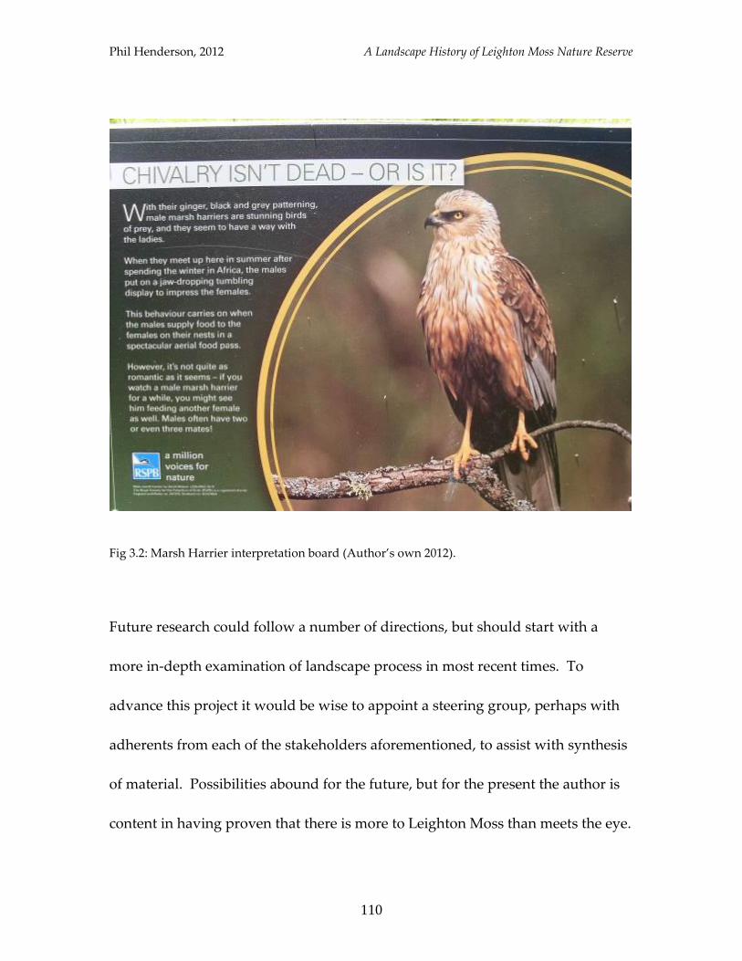
Phil Henderson, 2012 A Landscape History of Leighton Moss Nature Reserve
110
Fig 3.2: Marsh Harrier interpretation board (Author’s own 2012).
Future research could follow a number of directions, but should start with a
more in-depth examination of landscape process in most recent times. To
advance this project it would be wise to appoint a steering group, perhaps with
adherents from each of the stakeholders aforementioned, to assist with synthesis
of material. Possibilities abound for the future, but for the present the author is
content in having proven that there is more to Leighton Moss than meets the eye.
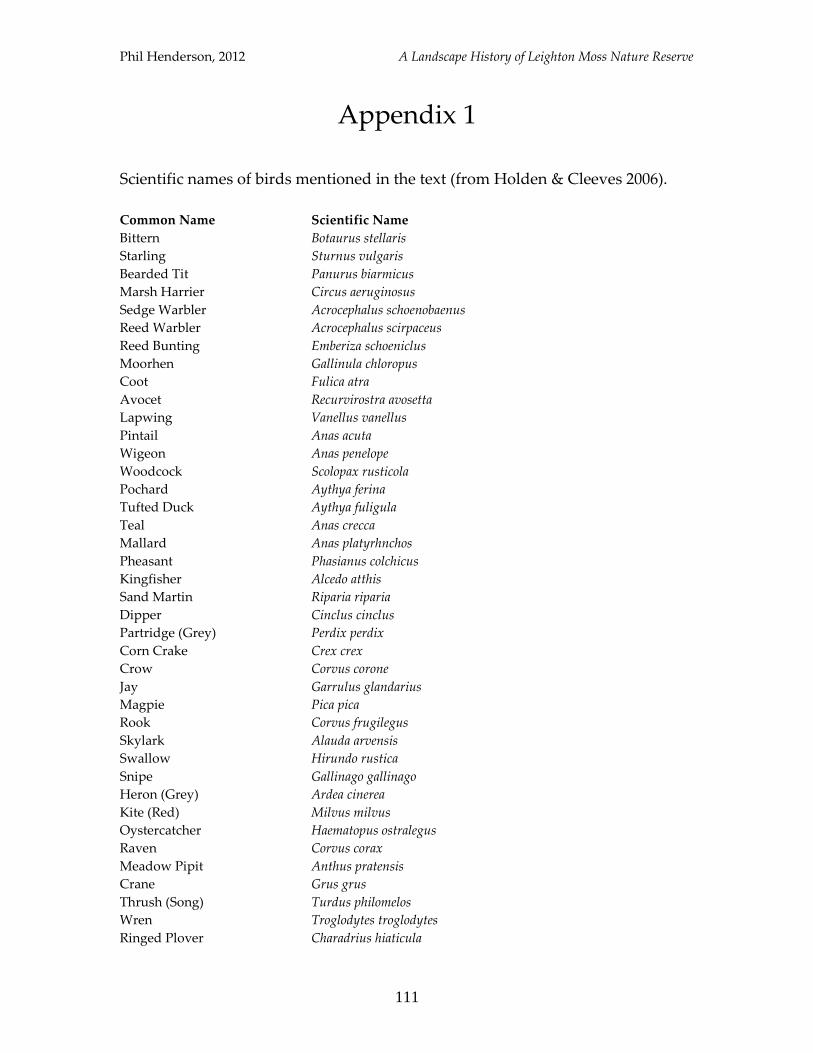
Phil Henderson, 2012 A Landscape History of Leighton Moss Nature Reserve
111
Appendix 1
Scientific names of birds mentioned in the text (from Holden & Cleeves 2006).
Common Name Scientific Name
Bittern Botaurus stellaris
Starling Sturnus vulgaris
Bearded Tit Panurus biarmicus
Marsh Harrier Circus aeruginosus
Sedge Warbler Acrocephalus schoenobaenus
Reed Warbler Acrocephalus scirpaceus
Reed Bunting Emberiza schoeniclus
Moorhen Gallinula chloropus
Coot Fulica atra
Avocet Recurvirostra avosetta
Lapwing Vanellus vanellus
Pintail Anas acuta
Wigeon Anas penelope
Woodcock Scolopax rusticola
Pochard Aythya ferina
Tufted Duck Aythya fuligula
Teal Anas crecca
Mallard Anas platyrhnchos
Pheasant Phasianus colchicus
Kingfisher Alcedo atthis
Sand Martin Riparia riparia
Dipper Cinclus cinclus
Partridge (Grey) Perdix perdix
Corn Crake Crex crex
Crow Corvus corone
Jay Garrulus glandarius
Magpie Pica pica
Rook Corvus frugilegus
Skylark Alauda arvensis
Swallow Hirundo rustica
Snipe Gallinago gallinago
Heron (Grey) Ardea cinerea
Kite (Red) Milvus milvus
Oystercatcher Haematopus ostralegus
Raven Corvus corax
Meadow Pipit Anthus pratensis
Crane Grus grus
Thrush (Song) Turdus philomelos
Wren Troglodytes troglodytes
Ringed Plover Charadrius hiaticula
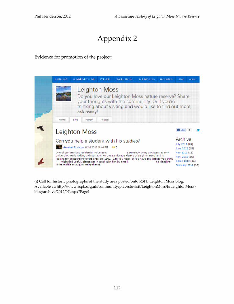
Phil Henderson, 2012 A Landscape History of Leighton Moss Nature Reserve
112
Appendix 2
Evidence for promotion of the project:
(i) Call for historic photographs of the study area posted onto RSPB Leighton Moss blog.
Available at: http://www.rspb.org.uk/community/placestovisit/LeightonMoss/b/LeightonMoss-
blog/archive/2012/07.aspx?PageI
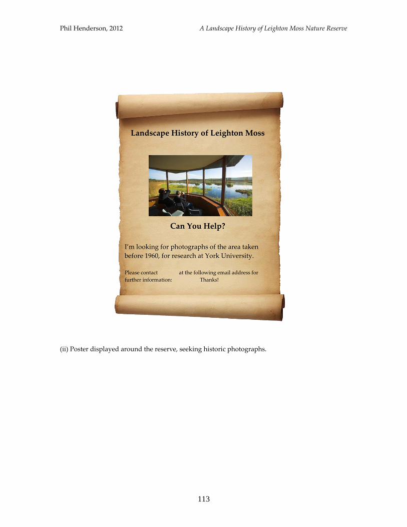
Phil Henderson, 2012 A Landscape History of Leighton Moss Nature Reserve
113
(ii) Poster displayed around the reserve, seeking historic photographs.
Can You Help?
I’m looking for photographs of the area taken
before 1960, for research at York University.
Please contact at the following email address for
further information: Thanks!
Landscape History of Leighton Moss
Phil Henderson, 2012 A Landscape History of Leighton Moss Nature Reserve
114
Bibliography
Primary Sources
Lancashire Record Office, DDX 1915/166, “RSPB Leighton Moss”.
Lancashire Record Office, DDX 2743/MS5444, “Translation of c.1200 grant by
Henry, son of Norman de Redman, of land in Yealand”.
Lancashire Record Office, PR572 [microfiche], “Churchwardens’ Accounts and
Vestry Minutes 1739-1865”.
Lancashire Record Office, AE 5/16, “Warton-with-Lindeth Enclosure Award”.
Lancashire Record Office, DRB 1/175, “Silverdale Tithe Map/Schedule”.
Lancashire Record Office, DRB 1/195, “Warton-with-Lindeth Tithe
Map/Schedule”.
Lancashire Record Office, DRB 1/219, “Yealand Conyers Tithe Map/Schedule”.
Lancashire Record Office, DRB 1/220, “Yealand Readmayne Tithe
Map/Schedule”.
Lancaster Gazette, 13th October 1804: “To Be Let”. Accessed 07/2012, available at
http://www.britishnewspaperarchive.co.uk
Lancaster Gazette, 11th October 1845: “Local Intelligence”. Accessed 07/2012,
available at http://www.britishnewspaperarchive.co.uk
Lancaster Gazette, 5th April 1851: “The Lancaster Church of England
Association”. Accessed 07/2012, available at
http://britishnewspaperarchive.co.uk
Leighton Hall Estate, “Leighton Estate Game Book No.1 (1923-2012)”.
Phil Henderson, 2012 A Landscape History of Leighton Moss Nature Reserve
115
Secondary Sources
Backhouse, J. 2001: “Medieval Birds in the Sherborne Missal”. The British Library.
Balee, W. 1998 (ed) “Advances in Historical Ecology”. Historical Ecology Series,
Columbia University Press, New York. pp 13-29.
Balee, W. 2006: “The Research Program of Historical Ecology”. Department of
Anthropology, New Orleans.
Booth, P.H.W. 2004 (re-print): “Warton in the Middle Ages”. Mourholme Local History
Society.
Carman, J. 1994: Data for the Future or an Amenity for the Present? The Values of the
Natural and Historic Wetland Environment” in M Cox (ed) “Wetlands Archaeology and
Nature Conservation”. HMSO, London. pp 18-23.
Charles-Cox, J. 1913: “Church Wardens’ Accounts”. Methuen & Co. Ltd., London.
Clarke, M. 1982: “The Ancient Parish of Warton: A Background View” in “Mourholme
Magazine of Local History, Vol.1, Issue 1”.
Coles, B. 2006: “Beavers in Britain’s Past”. Oxbow Books.
Cox, M. (ed) 1994: “Wetlands Archaeology and Nature Conservation”. HMSO, London.
Crumley, C. 1994: “Historical Ecology: Cultural Knowledge and Changing Landscapes”.
School of American Research Press, Santa Fe.
Dark, K. & Dark, P. 1997: “The Landscape of Roman Britain”. Sutton Publishing
Limited, Gloucestershire.
Dark, P. 2000: “The Environment of Britain in the First Millennium A.D.”. Duckworth.
Edina Digimap 2012. Available at: http//:digimap.edina.ac.uk/digimap/home
Egan, D. & Howell, E.A. 2001: “The historical ecology handbook: a restorationists guide
to reference ecosystems”. Island Press, London.
English Heritage 2012: “Pastscape”. Accessed 07/2012, available at:
http//:www.pastscape.org.uk
Phil Henderson, 2012 A Landscape History of Leighton Moss Nature Reserve
116
English Nature Cumbria Team, 1997: “Cumbria Fells and Dales Natural Area Profile”.
Accessed 08/2012, available at:
http://www.sssi.naturalengland.org.uk/science/natural/profiles%5CnaProfile10.pdf
Farrer, W. & Brownbill, J. 1914: “A History of the County of Lancaster: Volume 8”.
Farrer, W. & Brownbill, J. 1920: “A History of the County of Lancaster”. London.
Fellows-Jensen, G. 2007: “Another Look at the Danes in Lancashire” in Z Lawson (ed)
“Aspects of Lancashire History: Essays in Memory of Mary Higham”. Lancashire Local
History Federation. pp 18-27.
Ford, H.C. 1931: “Sketches of Yealand”. Atkinson & Pollitt, Kendal.
Fuller, R.J. 1982: “Bird Habitats in Britain”. T & AD Poyser.
Fuller-Maitland, J.A. & Ford, J.R. 1931: “John Lucas’s History of Warton Parish
(compiled 1710-1740)”. Titus Wilson & Son, Kendal.
Gardiner, M. 2008: “The Wider Context” in L Barber & G Priestley-Bell (eds) “Medieval
Adaptation, Settlement and Economy of a Coastal Wetland: The Evidence from around
Lydd, Romney Marsh, Kent”. Oxbow Books, Oxford. pp 296-304.
Gelling, M. 2007: “Place-names and landscapes in the north-west” in Z Lawson (ed)
“Aspects of Lancashire History: Essays in Memory of Mary Higham”. Lancashire Local
History Federation. pp 28-36.
Gilbert-Carter, H. 1955: “Glossary of the British Flora”. Cambridge University Press.
Harting, J.E. 1972 (re-print): “British Animals Extinct within Historic Times”. Paul P.B.
Minet, Chicheley, Buckinghamshire.
Holden, P. & Cleeves, T. 2006 (second edition): “RSPB Handbook of British Birds”.
Helm, London.
Holloway, S. 1996: “The Historical Atlas of Breeding Birds in Britain and Ireland: 1875-
1900”. T. & A.D. Poyser, London.
Horner, R. & Birnie, E. 2007: “Leighton Moss and Morecambe Bay Reserve Annual
Report for 2006-07, Management Plan Year 2”. RSPB.
Hoskins, W.G. 1972: “The Making of the English Landscape”. Book Club Associates,
London.
Phil Henderson, 2012 A Landscape History of Leighton Moss Nature Reserve
117
Howard-Davis, C. et al 1988: “Peat and the Past: A survey and assessment of the
prehistory of the lowland wetlands of North-west England”. Lancaster University.
Jackson, J.W. 2007 (re-print): “Third Report on the Exploration at Dog Holes, Warton
Crag, Lancs.” Bibliolife.
Johnson, M. 2007: “Ideas of Landscape”. Blackwell Publishing, Oxford.
Lovegrove, R. 2007: “Silent Fields: the long decline of a nation’s wildlife”. Oxford
University Press.
Meyer, W. & Crumley, C. 2011: “Historical Ecology: Using What Works to Cross the
Divide” in T Moore & L Armada (eds) “Atlantic Europe in the First Millennium BC:
Crossing the Divide”. Oxford University Press, Oxford.
Middleton, R. et al 1995: “North West Wetlands Survey 3: The Wetlands of North
Lancashire”. Lancaster Imprints, Lancaster University Archaeological Unit.
Millward, R. 1955: “Lancashire – The History of the Landscape”. Hodder & Stoughton,
London.
Mourholme Local History Society, 1998: “How It Was: A North Lancashire Parish in the
Seventeenth Century”.
Mourholme Local History Society, 2005: “Warton 1800-1850: How a North Lancashire
Parish Changed”.
Mourholme Local History Society, 2011: “Mourholme Magazines of Local History 1-61,
1982-2011” [CD-Rom].
Newman, R. (ed) 1996: “The Archaeology of Lancashire: Present State and Future
Priorities”. Lancaster University Archaeological Unit, Lancaster.
Parker, A.J. 1988: “The Birds of Roman Britain” in “Oxford Journal of Archaeology,
Volume 7”. Basil Blackwell, Oxford. pp 197-226.
Peter, D. 1987: “Silverdale” in B Ayre (ed) 2001: “From Keer to Kent”. Pagefast Print &
Publishing Ltd., Lancaster. pp 18-9.
Powell, T.G.E., Oldfield, F., Corcoran, J.X.W.P. 1971: Excavations in zone VII peat at
Storrs Moss, Lancashire England 1965-7” in J Coles (ed) “Proceedings of the Prehistoric
Society, Vol.37, part 1”. pp 112-37.
Phil Henderson, 2012 A Landscape History of Leighton Moss Nature Reserve
118
Rackham, O. 1986: “The History of the Countryside”. J.M. Dent & Sons Ltd., London.
Rieley, J.O. & Page, S.E. 1990: “Ecology of Plant Communities”. Longman Scientific and
Technical, New York.
Rippon, S. 2000: “The Transformation of Coastal Wetlands: Exploitation and
Management of Marshland Landscapes in North West Europe during the Roman and
Medieval Periods”. The British Academy, Oxford University Press.
Robinson, M. 1985: “Nature Conservation and Environmental Archaeology” in G
Lambrick (ed) 1985: “Archaeology and Nature Conservation”. Oxford University
Department for External Studies.
Schama, S. 1995: “Landscape and Memory”. Harper Collins, London.
Shrubb, M. 2003: “Birds, Scythes and Combines”. Cambridge University Press.
Simmons, I.G. 2001: “An Environmental History of Great Britain: from 10,000 years ago
to the present”. Edinburgh University Press.
Stallibrass, S. & Huntley, J.P. 1995: “Plant and Vertebrate Remains from Archaeological
Sites in Northern England: Data Reviews and Future Directions”. Research Report No.4,
Architectural and Archaeological Society of Durham and Northumberland, Durham.
Stockdale, J. 1978 (re-print): “Annals of Cartmel”. The Scholar Press Ltd., West Yorks.
Taylor, J.J., Innes, J.B., Jones, M.D.H. 1994: “Locating Prehistoric Wetland Sites by an
Integrated Palaeoenvironmental/Geophysical Survey Strategy at Little Haweswater,
Lancashire” in R Luff & P Rowley-Conwy (eds) “Whither Environmental Archaeology”.
Oxbow Monograph. pp 13-23.
Terrett, I.B. 1962: “Lancashire” in HC Darby & IS Maxwell (eds) “The Domesday
Geography of Northern England”. Cambridge University Press. pp 392-418.
Tilley, C. 1994: “A Phenomenology of Landscape: places, paths and monuments”. Berg,
Oxford.
Thomas, N. 1985: “Silverdale in 1563” in “Mourholme Magazine of Local History, Vol.3,
Issue 3”.
Van der Valk, A.G. 2006: “The Biology of Freshwater Wetlands”. Oxford University
Press.

Phil Henderson, 2012 A Landscape History of Leighton Moss Nature Reserve
119
Waltham, A.C. 1974: “The Limestones and Caves of North-West England”. David &
Charles: Newton Abbot.
Williamson, T. 1997: “Fish, Fur and Feather: Man and Nature in the Post-Medieval
Landscape” in K Barker & T Darvill (eds) “Making English Landscapes”. Bournemouth
University School of Conservation Sciences, Occasional Paper 3.
Wilson, J. 1987: “The bittern – a bird of mystery” in B Ayre (ed) 2001: “From Keer to
Kent”. Pagefast Print & Publishing Ltd., Lancaster. p5.
Wilson, J. (ed) 1988: “Leighton Moss and Morecambe Bay Reserve, Lancashire: The First
25 Years, 1964-88”. RSPB.
Woods, P.H. 1997: “Boyhood memories of the Keer” in B Ayre (ed) 2001: “From Keer to
Kent”. Pagefast Print & Publishing Ltd., Lancaster. pp 8-9.
Yalden, D. 1999: “The History of British Mammals”. T. & A.D. Poyser, London.
Yalden, D.W. & Albarella, U. 2009: “The History of British Birds”. Oxford University
Press.
Zong, Y. & Tooley, M.J. 1996: “Holocene sea-level changes and crustal
movements in Morecambe Bay, north-west England” in “Journal of Quaternary
Science, 11 (1). pp 43-58.