Embed Size (px)
Citation preview
HAL Id: hal-02189211https://hal.univ-reunion.fr/hal-02189211
Submitted on 19 Jul 2019
HAL is a multi-disciplinary open accessarchive for the deposit and dissemination of sci-entific research documents, whether they are pub-lished or not. The documents may come fromteaching and research institutions in France orabroad, or from public or private research centers.
L’archive ouverte pluridisciplinaire HAL, estdestinée au dépôt et à la diffusion de documentsscientifiques de niveau recherche, publiés ou non,émanant des établissements d’enseignement et derecherche français ou étrangers, des laboratoirespublics ou privés.
A Land Use/Land cover on the small Indian Oceanislands, an example of its use with the study of
vector-borne diseasesChristophe Révillion, Artadji Attoumane, Annelise Tran, Vincent Herbreteau
To cite this version:Christophe Révillion, Artadji Attoumane, Annelise Tran, Vincent Herbreteau. A Land Use/Landcover on the small Indian Ocean islands, an example of its use with the study of vector-borne diseases.Island Biology 2019, Jul 2019, Saint-Denis, France. �hal-02189211�
Introduction Material and methods
Classification results : Land cover and webmapping interface
.We used SPOT 5 satellite images (© CNES, Distribution Airbus Defense and Space) acquired between
July 2013 and July 2014. The SPOT5 images used are a pair of images for each island with a
panchromatic image at 2.5m resolution and a multispectral image with 4 channels (green, red, PRI and
MIR) at 10m resolution.
All additional vector data come from the OSM database. These are the main roads (key=highway;
values=primary; secondary; tertiary; residential) and agricultural zoning (landuse=farmland). On these
agricultural areas, additional tags are used when it comes to sugar cane (crop=sugarcane) which is a
dominant crop on the two largest islands studied, Réunion Island and Mauritius.
The classification algorithm is a hierarchical object-based image analysis method, implemented in
eCognition® software. Each object is described by attributes related to its reflectance, texture and
geometry. Our hierarchical classification process is organized into two levels. A first level of
segmentation with the objective of delineating agricultural and natural objects and a second level of
segmentation with a smaller scale factor to extract urban areas, isolated buildings and main roads.
All the methodology is described in a paper in the Data journal (Revillion et al., 2019).
References
Tran A., Kassié D. & Herbreteau V. (2016). Applications of Remote Sensing to the Epidemiology of Infectious Diseases: Some Examples. In: Land Surface Remote Sensing: Environment and Risks (eds.
Baghdadi N & Zribi M). Elsevier, pp. 295-315.
Révillion, C., Attoumane, A. & Herbreteau, V. (2019) Homisland-IO: Homogeneous Land Use/Land Cover over the Small Islands of the Indian Ocean. Data, 4, 82.
A Land Use/Land cover on the small Indian Ocean islands,
an example of its use with the study of vector-borne diseases
Applications in health research
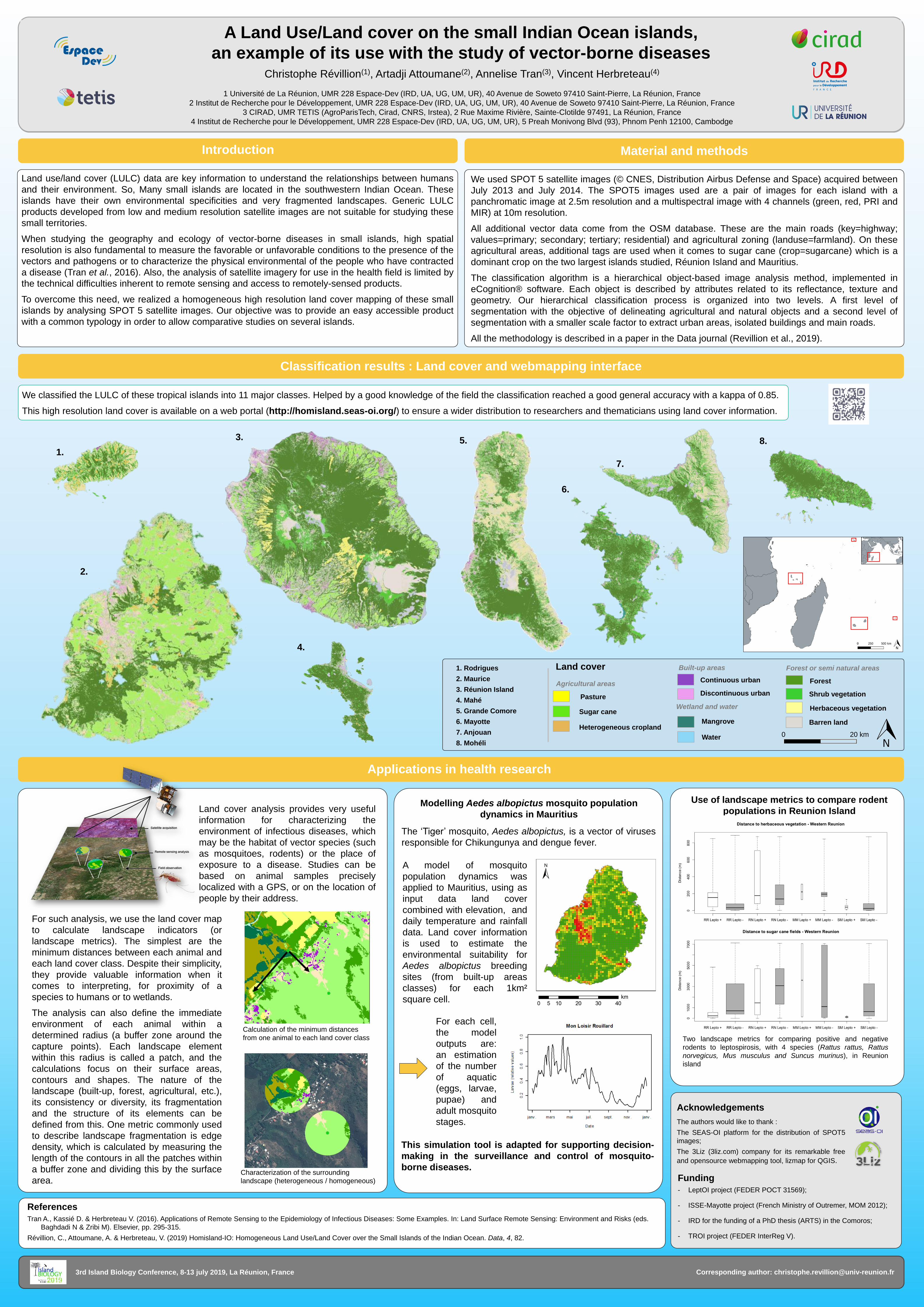
We classified the LULC of these tropical islands into 11 major classes. Helped by a good knowledge of the field the classification reached a good general accuracy with a kappa of 0.85.
This high resolution land cover is available on a web portal (http://homisland.seas-oi.org/) to ensure a wider distribution to researchers and thematicians using land cover information.
Christophe Révillion(1), Artadji Attoumane(2), Annelise Tran(3), Vincent Herbreteau(4)
1 Université de La Réunion, UMR 228 Espace-Dev (IRD, UA, UG, UM, UR), 40 Avenue de Soweto 97410 Saint-Pierre, La Réunion, France
2 Institut de Recherche pour le Développement, UMR 228 Espace-Dev (IRD, UA, UG, UM, UR), 40 Avenue de Soweto 97410 Saint-Pierre, La Réunion, France
3 CIRAD, UMR TETIS (AgroParisTech, Cirad, CNRS, Irstea), 2 Rue Maxime Rivière, Sainte-Clotilde 97491, La Réunion, France
4 Institut de Recherche pour le Développement, UMR 228 Espace-Dev (IRD, UA, UG, UM, UR), 5 Preah Monivong Blvd (93), Phnom Penh 12100, Cambodge
3. 5.
7.
8.
Acknowledgements
The authors would like to thank :
The SEAS-OI platform for the distribution of SPOT5
images;
The 3Liz (3liz.com) company for its remarkable free
and opensource webmapping tool, lizmap for QGIS.
Funding
- LeptOI project (FEDER POCT 31569);
- ISSE-Mayotte project (French Ministry of Outremer, MOM 2012);
- IRD for the funding of a PhD thesis (ARTS) in the Comoros;
- TROI project (FEDER InterReg V).
For such analysis, we use the land cover map
to calculate landscape indicators (or
landscape metrics). The simplest are the
minimum distances between each animal and
each land cover class. Despite their simplicity,
they provide valuable information when it
comes to interpreting, for proximity of a
species to humans or to wetlands.
The analysis can also define the immediate
environment of each animal within a
determined radius (a buffer zone around the
capture points). Each landscape element
within this radius is called a patch, and the
calculations focus on their surface areas,
contours and shapes. The nature of the
landscape (built-up, forest, agricultural, etc.),
its consistency or diversity, its fragmentation
and the structure of its elements can be
defined from this. One metric commonly used
to describe landscape fragmentation is edge
density, which is calculated by measuring the
length of the contours in all the patches within
a buffer zone and dividing this by the surface
area.
Land cover analysis provides very useful
information for characterizing the
environment of infectious diseases, which
may be the habitat of vector species (such
as mosquitoes, rodents) or the place of
exposure to a disease. Studies can be
based on animal samples precisely
localized with a GPS, or on the location of
people by their address.
Calculation of the minimum distances
from one animal to each land cover class
Characterization of the surrounding
landscape (heterogeneous / homogeneous)
Use of landscape metrics to compare rodent
populations in Reunion Island
Two landscape metrics for comparing positive and negative
rodents to leptospirosis, with 4 species (Rattus rattus, Rattus
norvegicus, Mus musculus and Suncus murinus), in Reunion
island
6.
4.
Land use/land cover (LULC) data are key information to understand the relationships between humans
and their environment. So, Many small islands are located in the southwestern Indian Ocean. These
islands have their own environmental specificities and very fragmented landscapes. Generic LULC
products developed from low and medium resolution satellite images are not suitable for studying these
small territories.
When studying the geography and ecology of vector-borne diseases in small islands, high spatial
resolution is also fundamental to measure the favorable or unfavorable conditions to the presence of the
vectors and pathogens or to characterize the physical environmental of the people who have contracted
a disease (Tran et al., 2016). Also, the analysis of satellite imagery for use in the health field is limited by
the technical difficulties inherent to remote sensing and access to remotely-sensed products.
To overcome this need, we realized a homogeneous high resolution land cover mapping of these small
islands by analysing SPOT 5 satellite images. Our objective was to provide an easy accessible product
with a common typology in order to allow comparative studies on several islands.
3rd Island Biology Conference, 8-13 july 2019, La Réunion, France Corresponding author: [email protected]
Land cover Built-up areas
Continuous urban
Discontinuous urban
Forest or semi natural areas
Forest
Shrub vegetation
Herbaceous vegetation
Barren land
Agricultural areas
Pasture
Sugar cane
Heterogeneous cropland
Wetland and water
Mangrove
Water
1. Rodrigues
2. Maurice
3. Réunion Island
4. Mahé
5. Grande Comore
6. Mayotte
7. Anjouan
8. Mohéli
0 20 km
1.
2.
Modelling Aedes albopictus mosquito population
dynamics in Mauritius
The ‘Tiger’ mosquito, Aedes albopictus, is a vector of viruses
responsible for Chikungunya and dengue fever.
For each cell,
the model
outputs are:
an estimation
of the number
of aquatic
(eggs, larvae,
pupae) and
adult mosquito
stages.
This simulation tool is adapted for supporting decision-
making in the surveillance and control of mosquito-
borne diseases.
A model of mosquito
population dynamics was
applied to Mauritius, using as
input data land cover
combined with elevation, and
daily temperature and rainfall
data. Land cover information
is used to estimate the
environmental suitability for
Aedes albopictus breeding
sites (from built-up areas
classes) for each 1km²
square cell.