Embed Size (px)
Citation preview
LEED 2009 for NEighborhooD DEvELopmENt
18
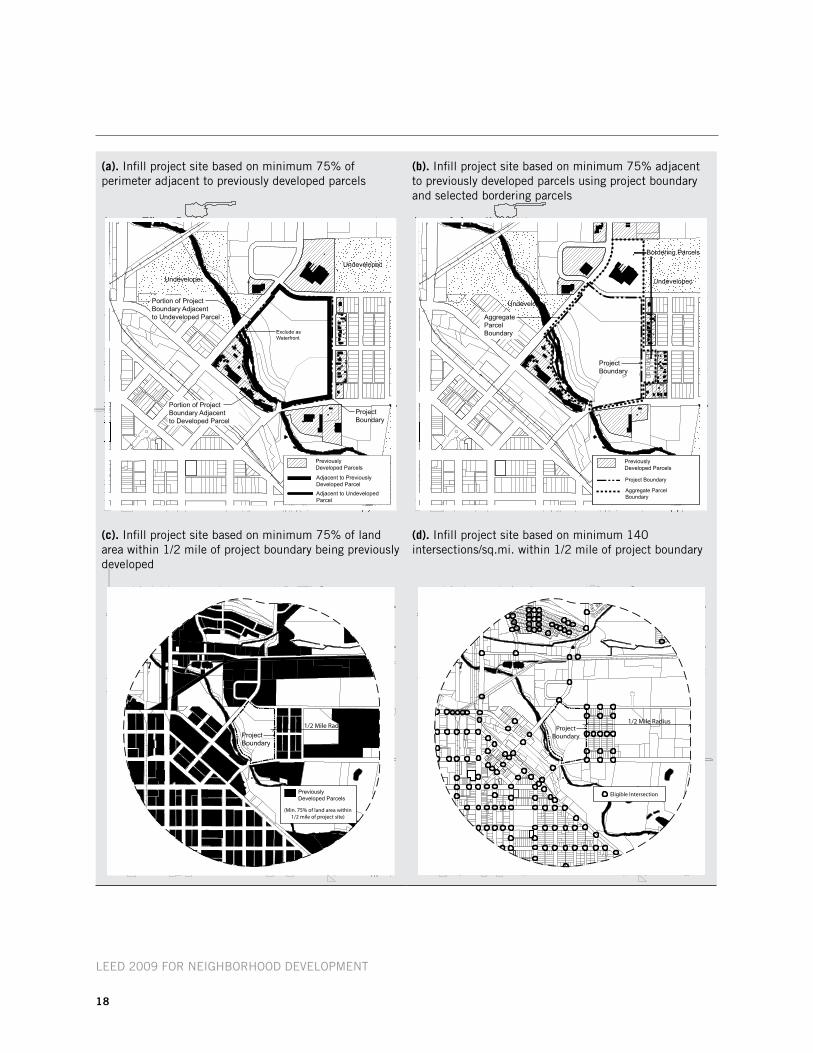
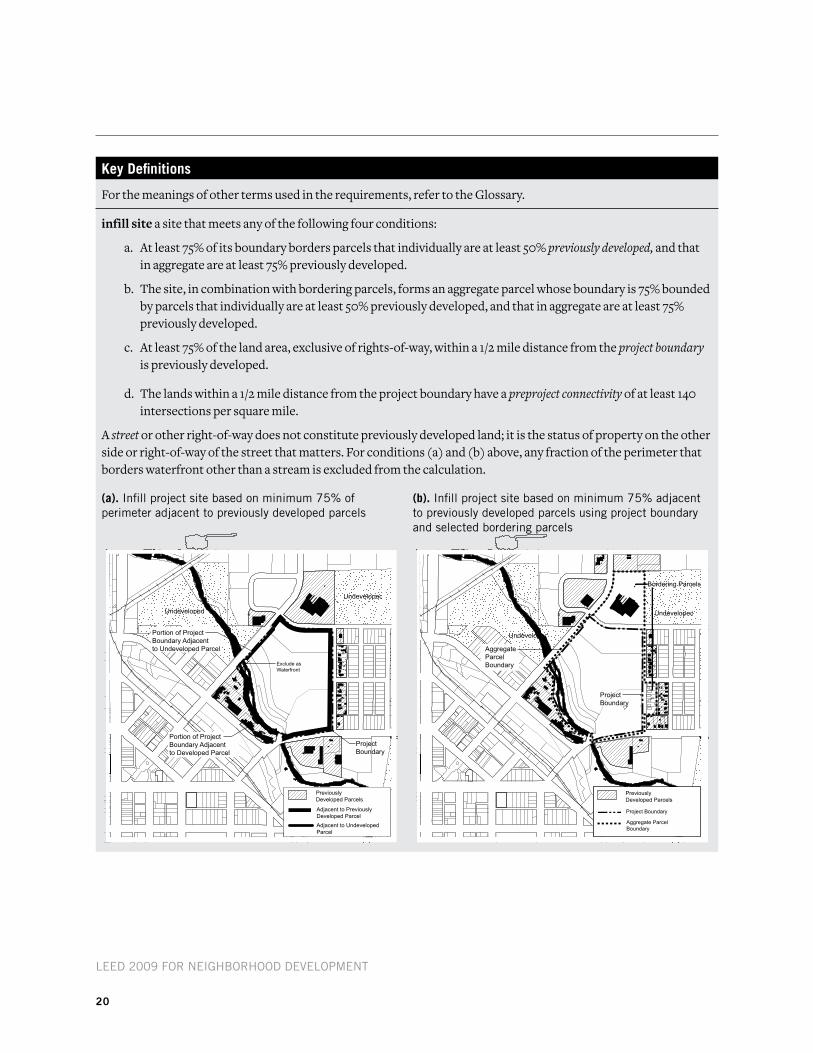
(a). infill project site based on minimum 75% of perimeter adjacent to previously developed parcels
(b). infill project site based on minimum 75% adjacent to previously developed parcels using project boundary and selected bordering parcels
(c). infill project site based on minimum 75% of land area within 1/2 mile of project boundary being previously developed
(d). infill project site based on minimum 140 intersections/sq.mi. within 1/2 mile of project boundary
LEED 2009 for NEighborhooD DEvELopmENt
19
Sll prerequisite 5: Floodplain avoidance
required
intentTo protect life and property, promote open space and habitat conservation, and enhance water quality and natural hydrological systems.
requirement
optioN 1. Sites without floodplainsLocate on a site that does not contain any land within a 100-year high- or moderate-risk floodplain as defined and mapped by the Federal Emergency Management Agency (FEMA) or a state or local floodplain management agency, whichever is more recent.
or
optioN 2. infill or previously Developed Sites with floodplainsLocate the project on an infill site or a previously developed site or in a nonconveyance area of river or coastal floodplain without storm surge potential where compensatory storage is used in accordance with a FEMA-approved mitigation plan. Comply with the National Flood Insurance Program (NFIP) requirements for developing any portions of the site that lie within a 100-year high-or moderate-risk floodplain, as defined in Option 1. If the project includes construction of any critical facility, such as a hospital, water and sewage treatment facility, emergency center, or fire or police station, the critical facility must be designed and built so as to be protected and operable during a 500-year event, as defined by FEMA.
or
optioN 3. All other Sites with floodplainsIf any part of the site is located within a 100-year high- or moderate-risk floodplain, as defined above, develop only on portions of the site that are not in the floodplain, or that have been previously developed, or that are in a nonconveyance area of river or coastal floodplain without storm surge potential where compensatory storage is used in accordance with a FEMA-approved mitigation plan. Previously developed portions in the floodplain must be developed according to NFIP requirements. If development includes construction of any critical facility, as described above, the critical facility must be designed and built so as to be protected and operable during a 500-year event, as defined by FEMA.
LEED 2009 for NEighborhooD DEvELopmENt
20
key Definitions
For the meanings of other terms used in the requirements, refer to the Glossary.
infill site a site that meets any of the following four conditions:
a. At least 75% of its boundary borders parcels that individually are at least 50% previously developed, and that in aggregate are at least 75% previously developed.
b. The site, in combination with bordering parcels, forms an aggregate parcel whose boundary is 75% bounded by parcels that individually are at least 50% previously developed, and that in aggregate are at least 75% previously developed.
c. At least 75% of the land area, exclusive of rights-of-way, within a 1/2 mile distance from the project boundary is previously developed.
d. The lands within a 1/2 mile distance from the project boundary have a preproject connectivity of at least 140 intersections per square mile.
A street or other right-of-way does not constitute previously developed land; it is the status of property on the other side or right-of-way of the street that matters. For conditions (a) and (b) above, any fraction of the perimeter that borders waterfront other than a stream is excluded from the calculation.
(a). infill project site based on minimum 75% of perimeter adjacent to previously developed parcels
(b). infill project site based on minimum 75% adjacent to previously developed parcels using project boundary and selected bordering parcels