Embed Size (px)
Citation preview
1
A Guide to Using the Pennsylvania
GroundWater Information System (PaGWIS)
Department of Conservation and Natural Resources
Bureau of Topographic and Geologic Survey
3240 Schoolhouse Road
Middletown, PA 17057-3534
April 2016
Contents
PaGWIS Quick Start Guide .............................................................................................................................. 2 General Information .......................................................................................................................................... 3
Changes to PaGWIS ..................................................................................................................................... 3 System Notes ................................................................................................................................................ 3
PaGWIS Basics ................................................................................................................................................. 4 Datum and Accuracy of Coordinates ............................................................................................................ 4 Data Packages ............................................................................................................................................... 4 Wells: Data Packages .................................................................................................................................... 4
Springs: Data Packages ................................................................................................................................. 5 Search Tools.................................................................................................................................................. 5
Multiple Search Criteria ............................................................................................................................ 5 Map Search ............................................................................................................................................... 7
Reports .......................................................................................................................................................... 8 Water Well Information Report ................................................................................................................ 8 Spring Information Report ...................................................................................................................... 10
Frequently Asked Questions ........................................................................................................................... 11 Definitions of parameters found in PaGWIS by Download Package ............................................................. 13
Wells General Info Package........................................................................................................................ 13
Wells Site Info Package .............................................................................................................................. 14 Wells Well Construction Package .............................................................................................................. 15
Wells Hydrogeologic Package .................................................................................................................... 17 Wells Geologic Package ............................................................................................................................. 18
Spring General Info Data Package .............................................................................................................. 19 Spring Hydrogeologic Data Package .......................................................................................................... 20 Spring Lab Water Quality Data Package .................................................................................................... 21 Spring Field Water Quality Data Package .................................................................................................. 21
2
PaGWIS Quick Start Guide
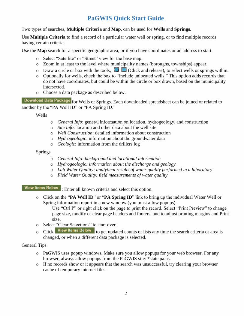
Two types of searches, Multiple Criteria and Map, can be used for Wells and Springs.
Use Multiple Criteria to find a record of a particular water well or spring, or to find multiple records
having certain criteria.
Use the Map search for a specific geographic area, or if you have coordinates or an address to start.
o Select “Satellite” or “Street” view for the base map.
o Zoom in at least to the level where municipality names (boroughs, townships) appear.
o Draw a circle or box with the tools, (Click and release), to select wells or springs within.
o Optionally for wells, check the box to “Include unlocated wells.” This option adds records that
do not have coordinates, but could be within the circle or box drawn, based on the municipality
intersected.
o Choose a data package as described below.
for Wells or Springs. Each downloaded spreadsheet can be joined or related to
another by the “PA Well ID” or “PA Spring ID.”
Wells
o General Info: general information on location, hydrogeology, and construction
o Site Info: location and other data about the well site
o Well Construction: detailed information about construction
o Hydrogeologic: information about the groundwater data
o Geologic: information from the drillers log
Springs
o General Info: background and locational information
o Hydrogeologic: information about the discharge and geology
o Lab Water Quality: analytical results of water quality performed in a laboratory
o Field Water Quality: field measurements of water quality
: Enter all known criteria and select this option.
o Click on the “PA Well ID” or “PA Spring ID” link to bring up the individual Water Well or
Spring information report in a new window (you must allow popups).
Use “Ctrl P” or right click on the page to print the record. Select “Print Preview” to change
page size, modify or clear page headers and footers, and to adjust printing margins and Print
size.
o Select “Clear Selections” to start over.
o Click to get updated counts or lists any time the search criteria or area is
changed, or when a different data package is selected.
General Tips
o PaGWIS uses popup windows. Make sure you allow popups for your web browser. For any
browser, always allow popups from the PaGWIS site: *state.pa.us.
o If no records show or it appears that the search was unsuccessful, try clearing your browser
cache of temporary internet files.
3
General Information
Changes to PaGWIS
A map search function is now included. A check box is available to include records that do not have
coordinates, but are located in the intersected municipalities of the map search.
Individual Well Reports are better organized and presented.
Spring Information Reports are now provided with PaGWIS.
PaGWIS no longer contains water quality data, which were only a one-time upload of U.S.
Geological Survey (USGS) legacy data on water quality. Wells in PaGWIS that have associated
USGS water-quality data are those that The “SiteID” column numbers in the Site Info download
packages can be used to retrieve water quality data for selected wells. If a well has a SiteID number,
use that number to download USGS water quality data at http://waterdata.usgs.gov/nwis/qw. Select
the “Field/Lab samples” button on the USGS web site. Use the SiteID number in PaGWIS to search
for water quality data by “Site Number” under “Site Identifier” on the USGS web page for Site
Location of Pennsylvania. For springs, some laboratory and field water quality information is
maintained in PaGWIS; however, additional water quality data may be accessed from the USGS.
The Microsoft Access database is no longer maintained or offered with PaGWIS. Through the data
downloads packages, PaGWIS provides all the available data by user-defined criteria.
At the request of Pa. Department of Environmental Protection (DEP), data on wells or springs that
are used for public water supplies are no longer included. Please contact DEP for more information
on specific public water supplies: http://www.dep.pa.gov
System Notes
PaGWIS uses popup windows. Make sure you allow popups for your web browser. For any browser,
always allow popups from the PaGWIS site: *state.pa.us.
If no records show or it appears that the search was unsuccessful, try clearing your browser cache of
temporary internet files.
The map search is an intensive process. Please be patient as retrievals typically take 50 to 60
seconds. Slower Internet connections may even cause retrievals to take longer.
Use the “Contact Us” button to email the bureau with questions and comments. The email address is
[email protected], and is not case-sensitive.
4
Basics
Datum and Accuracy of Coordinates
Most record locations should be considered approximate unless field verified. In fact, the original goal of
the water well program in the 1970s into the 1980s was to place the well within a mile of its probable true
location.
In PaGWIS, coordinates are formatted in decimal degrees to 5 decimal points. In Pennsylvania, the
horizontal difference of the fifth decimal point for latitude and longitude is less than 5.0 feet. This represents
the best accuracy that coordinates may have when expressed to five decimal places. Nearly all assigned
coordinates are not accurate to the fifth decimal place.
All geographic coordinates are with respect to a particular datum, that is, a reference geographic framework.
Typically, the datums used in PaGWIS are either North American Datum of 1927 (NAD27), North
American Datum of 1983 (NAD83), or World Geodetic System of 1984 (WGS84). WGS84 is associated
with many GPS units and online map applications, and is within a few feet difference of NAD1983.
For purposes of PaGWIS, NAD83 and WGS84 are virtually the same. Though accuracy of well locations
varies widely, the difference in coordinates based on the datum could be an additional source of error in the
well location. In general, in Pennsylvania, the horizontal differences between the NAD27 and NAD83
datums are location dependent and can range roughly from 60 to 110 feet, which is typically less than the
overall accuracy of the reported location.
In the “Site Info” download package, the column “LatLongAccuracy” may have an entry that reflects some
assessment of accuracy. In addition, this package includes the method of how coordinates were assigned, as
listed in the column “DrillersCoordMethod.” These entries may also be useful in assessing accuracy of the
location or its datum. Finally, this data package also includes a column on “DataReliability,” which may
indicate whether the location is field-checked.
Coordinates in PaGWIS could be in any of the three datums, though some groups of records are more likely
to be a particular datum. Using “Site Info” download packages, records with the “Data Reliability” column
that are marked as “FIELD CHECKED BY REPORTING AGENCY” are in NAD27. Records submitted
after June 1, 2009 and marked under “SourceOfSiteRecord” as “PaGS WWI Electronic” are typically in
NAD83 (or WGS84).
Data Packages
For Wells and Springs, data-package options were designed for different uses. The following are description
of the data packages for Wells and Springs. For many records, only basic skeletal information has been
entered into PaGWIS: county, municipality, well owner, driller, and date drilled, though an image of an
original paper record may be available. Because of the relational nature of the database, wells may have
more than one line in the download.
Wells Data Packages
General Info: a general purpose download package that covers aspects of the site and primary
parameters of a water well. Includes location data such as county, municipality, quadrangle,
address, and zip code, coordinates, date drilled, driller, owner, well and water uses, depth, casing
information, depth to bedrock, yield and measurement method, water levels, saltwater zones,
whether there is a paper record image associated with the report, and if so, a link to the image of
the record, and remarks. Parameters unique to this package include: type of activity and well use.
This package typically results in one record per well, but multiple casings may result in multiple
lines for those wells.
5
Site Info: a download package about the well; includes other identification numbers like USGS
site numbers and local well numbers, location information such as county, municipality,
quadrangle, coordinates, location accuracy indicators, address information, owner, topography,
elevation and the method used to determine elevation, water use, use of site, source of the record,
whether there is a paper record image associated with the report, and if so, a link to the image of
the record, other identifiers, and driller or other remarks. Parameters unique to this package
include: LatLon accuracy, owner first name, source of the site record, other identifiers, who
created the other identifiers, local permit numbers, and dates of remarks. This package typically
results in one record per well, but multiple owners may result in multiple lines for those wells.
Well Construction: a download package regarding the well’s construction including methods,
materials, components, and dimensions. This package occasionally results in more than one
record per well.
Hydrogeologic: a download package regarding groundwater data including yield, water levels,
water-bearing zones, other details, etc. This package occasionally results in more than one record
per well.
Geologic: a download package from the driller’s log such as materials encountered and their
depth intervals, depth to bedrock, and whether bedrock was not reached. An interpretation of the
geologic formation has been assigned for some records. This was typically made by the Bureau
of Topographic and Geologic Survey or the USGS, This package typically results in more than
one record per well.
Springs Data Packages
General Info: a general purpose download package that covers aspects of the site and primary
parameters of a spring. Includes spring name(s), location data such as county, municipality,
quadrangle, and coordinates, elevation and its accuracy, topography, date owned, source of the
record and any explanation, site and water uses, whether there have been “improvements” on the
spring, data reliability, and other identifiers and remarks. This package typically results in one
record per spring.
Hydrogeologic: a download package regarding geologic and groundwater data including
hydrologic unit, spring type, its permanence, sphere of discharge and number of openings,
geologic formation and lithology, contributing unit, discharge type, source of data, discharge
rate, method of discharge measurement, by whom, and the date of measurement. This package
occasionally results in more than one record per spring because of multiple discharge
measurements.
Lab Water Quality: a download package of analytical results of water quality from a
laboratory. These are typically analytical results from the USGS (contact the USGS for
additional data). This package typically results in more than one record per spring.
Field Water Quality: a download package of analytical results of water quality from field visits.
These records are typically field measurements from the Bureau of Topographic and Geologic
Survey or the USGS (contact the USGS for additional data). This package typically results in
more than one record per spring.
Search Tools
Multiple Search Criteria
On the Multiple Criteria Search screen, you may enter criteria to restrict a search for water wells and
springs. You must enter at least one criterion.
For water wells, you can restrict the results by selecting one or more of the following.
6
1. County. This will result in a list of wells only for that County (further restricted by any other criteria
you enter).
2. Municipality (also requires County). This will result in a list of wells only for that municipality,
within the County you selected.
3. PA Well ID (restricts the results to one well)
4. Driller License number. This will result in a list of wells drilled only by that driller.
5. Date Drilled. This can be a single date, or a date range in the format mm/dd/yyyy. Leaving the start
or end date blank will result in an open-ended range. If you want to select a specific date, enter that
date into both fields.
6. Driller’s name. You may enter all or part of the last name or company name. This will result in a
list of wells drilled only by that driller, or all of the drillers matching the partial name entry.
7. Well Owner. You may enter all or part of the name of the well owner. This will result in a list of
wells owned only by that owner, or all of the owners matching the partial name entry. The Owner
name is the name of the owner at the time the well was drilled, and may not be the current owner.
8. Driller Well Reference number. This is an ID number assigned to a well by the driller, for
submission via our online well submission system, WebDriller. It works best in conjunction with
the driller’s name or license number.
The more criteria you can enter, the faster the extraction will run, and the more restricted your list will be.
If your list is very long, try entering an additional criterion. If you get no results, or not the desired result,
try removing one of the criteria.
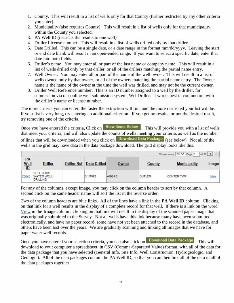
Once you have entered the criteria, Click on . This will provide you with a list of wells
that meet your criteria, and will also update the counts of wells meeting your criteria, as well as the number
of lines that will be downloaded when you click on (see below). Not all of the
wells in the grid may have data in the data package download. The grid display looks like this.
For any of the columns, except Image, you may click on the column header to sort by that column. A
second click on the same header name will sort the list in the reverse order.
Two of the column headers are blue links. All of the lines have a link in the PA Well ID column. Clicking
on that link for a well results in the display of a complete record for that well. If there is a link on the word
View in the Image column, clicking on that link will result in the display of the scanned paper image that
was originally submitted to the Survey. Not all wells have this link because many have been submitted
electronically, and have no paper record, some have not yet been attached to the record in the database, and
others have been lost over the years. We are gradually scanning and linking all images that we have for
paper water well records.
Once you have entered your selection criteria, you can also click on . This will
download to your computer a spreadsheet, in CSV (Comma-Separated Value) format, with all of the data for
the data package that you have selected (General Info, Site Info, Well Construction, Hydrogeologic, and
Geologic). All of the data packages contain the PA Well ID, so that you can then link all of the data in all of
the data packages together.
7
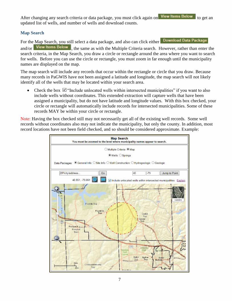
After changing any search criteria or data package, you must click again on to get an
updated list of wells, and number of wells and download counts.
Map Search
For the Map Search, you still select a data package, and also can click either
and/or , the same as with the Multiple Criteria search. However, rather than enter the
search criteria, in the Map Search, you draw a circle or rectangle around the area where you want to search
for wells. Before you can use the circle or rectangle, you must zoom in far enough until the municipality
names are displayed on the map.
The map search will include any records that occur within the rectangle or circle that you draw. Because
many records in PaGWIS have not been assigned a latitude and longitude, the map search will not likely
identify all of the wells that may be located within your search area.
Check the box “Include unlocated wells within intersected municipalities” if you want to also
include wells without coordinates. This extended extraction will capture wells that have been
assigned a municipality, but do not have latitude and longitude values. With this box checked, your
circle or rectangle will automatically include records for intersected municipalities. Some of these
records MAY be within your circle or rectangle.
Note: Having the box checked still may not necessarily get all of the existing well records. Some well
records without coordinates also may not indicate the municipality, but only the county. In addition, most
record locations have not been field checked, and so should be considered approximate. Example:
8
The circle covers part of Center and Franklin Townships in Butler County. Having the box checked will
extract data for
1. all wells WITH a latitude and longitude within the circle,
AND
2. all wells WITHOUT a latitude and longitude in Center and Franklin Townships.
The Map search runs slower than the Multiple Criteria search, so be patient while waiting for the results.
For Springs, everything works the same as for Wells. The Multiple Search Criteria has fewer fields to use to
restrict the data results, and there are no scanned images of any paper records. Because all springs have
coordinates, there is no box to select records without coordinates.
Reports
Water Well Information Report
When you click on a PA Well ID, a pop-up window will appear with a complete well record report for the
well selected. The report is divided into several sections. You must have pop-ups enabled on your browser
to see the report.
The Location Information section provides information about the location of the well – county,
municipality, latitude and longitude, owner name, well address, as well as any comments.
The Well Construction Information provides information on the construction characteristics of the water
well, such as the driller and license number, who was the original driller, if this is not a new well, the
activity (new well, drill deeper, etc.) date drilled and drilling method, well depth, and well finish (open hole,
screened, etc.).
There are several subsections under Well Construction. Well Size provides information on the top and
bottom, and diameter of different sections of the well. Most home wells have a single entry. Casing
information indicates the top, bottom, and diameter of various segments of casing, plus information on
sealant, if the casing is cemented into the well. Again, most private home wells have a single entry.
Screen/Slot indicates information on any screened intervals of the well- top, bottom, and diameter of the
screened interval, type, material, and size of the openings of the screen, and the type of material packed
around the screen. If the well has a liner, there will be info in the Well Liner section, indicating the top,
bottom, diameter, and type of liner. If sections of the well are isolated, information will appear in the
Packer section.
The Groundwater and Geological Information section provides information on the water produced by the
well, and the materials penetrated by the well. Water information includes the estimated well yield, the
method used to determine the yield, the water levels before the yield test was started, and also when it was
completed, and how long the test lasted. Also, the depths of levels or zones within the well where water
enters the well, and if the well encountered saltwater will be indicated. The use of the well and water when
the well was drilled is also provided.
The geological information is the driller’s log, a list of materials penetrated by the well and their tops and
bottoms below the ground surface. The depth to solid bedrock is indicated, and whether or not the bottom of
the well is in bedrock.
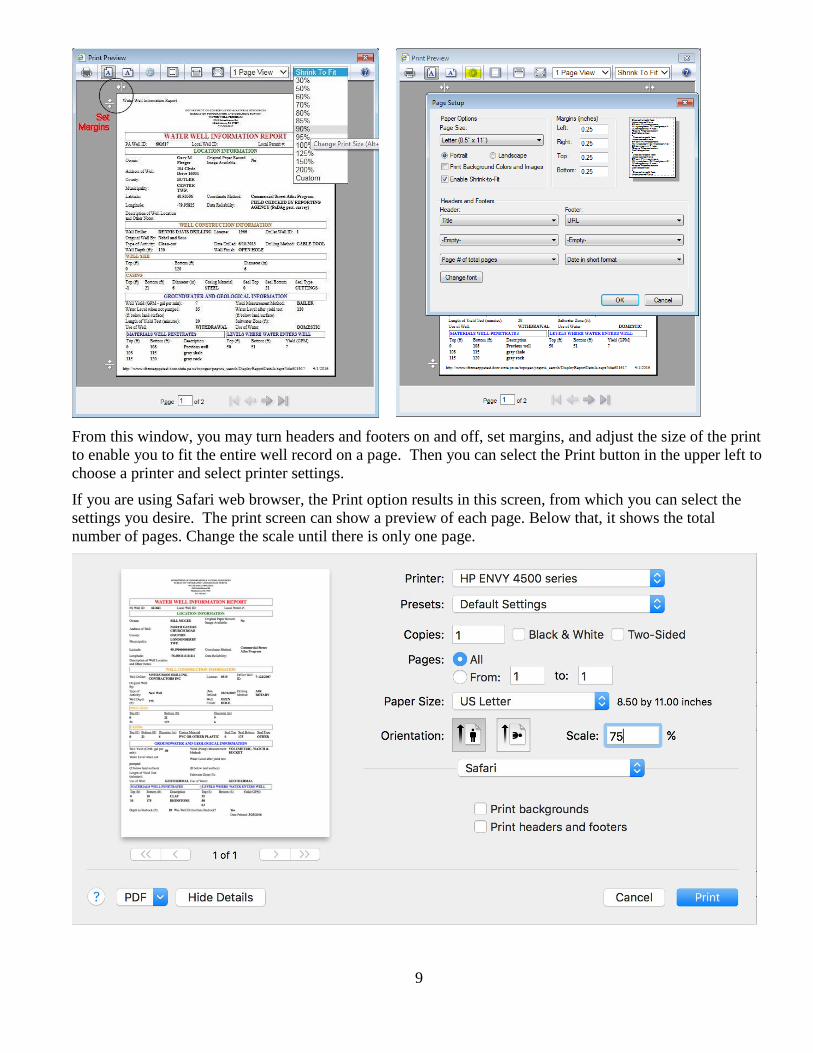
The well information reports sometimes can exceed a single 8½” x 11” page. Depending on the browser
that you are using, you may be able to reduce the size of the print to allow it to fit on a single page. The best
way to print a well information report depends on the browser that you are using. The following instructions
are for using Internet Explorer 11.
Right-click on the displayed well information report, and select Print Preview.
9
From this window, you may turn headers and footers on and off, set margins, and adjust the size of the print
to enable you to fit the entire well record on a page. Then you can select the Print button in the upper left to
choose a printer and select printer settings.
If you are using Safari web browser, the Print option results in this screen, from which you can select the
settings you desire. The print screen can show a preview of each page. Below that, it shows the total
number of pages. Change the scale until there is only one page.
10
Spring Information Report
When you click on a PA Spring ID, a pop-up window will appear with a complete spring record report for
the spring selected. You must have pop-ups enabled on your browser to see the report.
The report is divided into three sections.
The ID section provides information about the name of the spring: its ID, and information on data
reliability, spring improvements, and a description or other notes about the spring.
The Location Information section provides locational information of the spring.
The Hydrogeological Information section provides information on the hydrogeological aspects of the spring,
such as geologic formation, rock type, discharge environment, spring type, discharge average and number of
measurements, and the permanence of the spring. Note that additional information may be available with the
Data Package downloads.
11
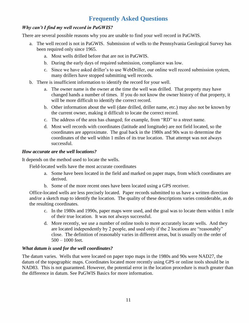
Frequently Asked Questions
Why can’t I find my well record in PaGWIS?
There are several possible reasons why you are unable to find your well record in PaGWIS.
a. The well record is not in PaGWIS. Submission of wells to the Pennsylvania Geological Survey has
been required only since 1965.
a. Most wells drilled before that are not in PaGWIS.
b. During the early days of required submission, compliance was low.
c. Since we have asked driller’s to use WebDriller, our online well record submission system,
many drillers have stopped submitting well records.
b. There is insufficient information to identify the record for your well.
a. The owner name is the owner at the time the well was drilled. That property may have
changed hands a number of times. If you do not know the owner history of that property, it
will be more difficult to identify the correct record.
b. Other information about the well (date drilled, driller name, etc.) may also not be known by
the current owner, making it difficult to locate the correct record.
c. The address of the area has changed; for example, from “RD” to a street name.
d. Most well records with coordinates (latitude and longitude) are not field located, so the
coordinates are approximate. The goal back in the 1980s and 90s was to determine the
coordinates of the well within 1 miles of its true location. That attempt was not always
successful.
How accurate are the well locations?
It depends on the method used to locate the wells.
Field-located wells have the most accurate coordinates
a. Some have been located in the field and marked on paper maps, from which coordinates are
derived.
b. Some of the more recent ones have been located using a GPS receiver.
Office-located wells are less precisely located. Paper records submitted to us have a written direction
and/or a sketch map to identify the location. The quality of these descriptions varies considerable, as do
the resulting coordinates.
c. In the 1980s and 1990s, paper maps were used, and the goal was to locate them within 1 mile
of their true location. It was not always successful.
d. More recently, we use a number of online tools to more accurately locate wells. And they
are located independently by 2 people, and used only if the 2 locations are “reasonably”
close. The definition of reasonably varies in different areas, but is usually on the order of
500 – 1000 feet.
What datum is used for the well coordinates?
The datum varies. Wells that were located on paper topo maps in the 1980s and 90s were NAD27, the
datum of the topographic maps. Coordinates located more recently using GPS or online tools should be in
NAD83. This is not guaranteed. However, the potential error in the location procedure is much greater than
the difference in datum. See PaGWIS Basics for more information.
12
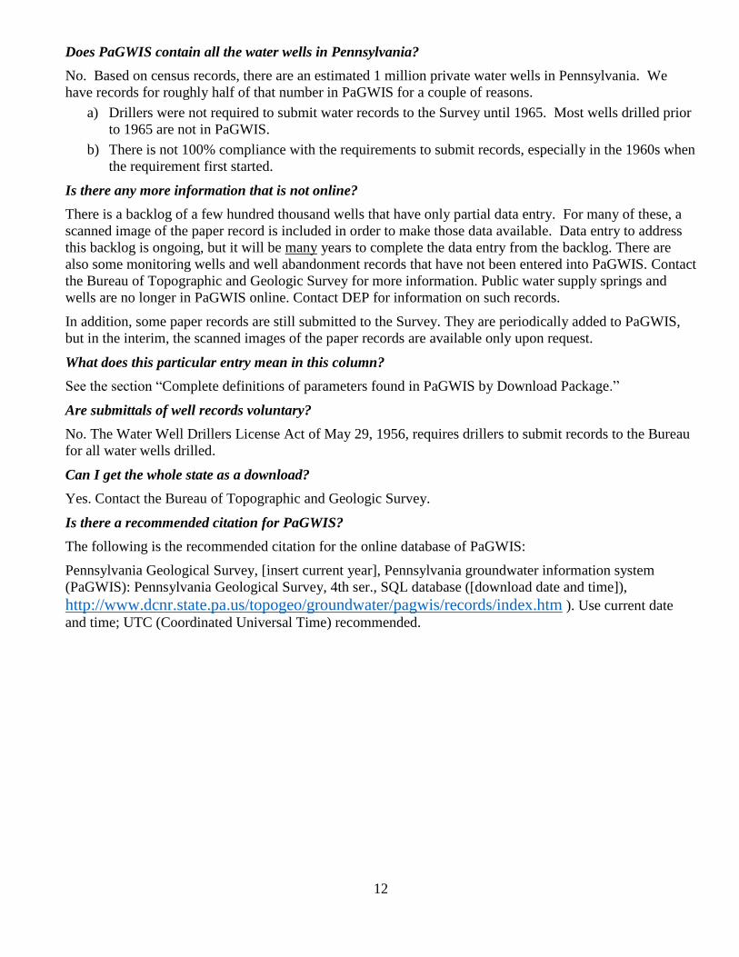
Does PaGWIS contain all the water wells in Pennsylvania?
No. Based on census records, there are an estimated 1 million private water wells in Pennsylvania. We
have records for roughly half of that number in PaGWIS for a couple of reasons.
a) Drillers were not required to submit water records to the Survey until 1965. Most wells drilled prior
to 1965 are not in PaGWIS.
b) There is not 100% compliance with the requirements to submit records, especially in the 1960s when
the requirement first started.
Is there any more information that is not online?
There is a backlog of a few hundred thousand wells that have only partial data entry. For many of these, a
scanned image of the paper record is included in order to make those data available. Data entry to address
this backlog is ongoing, but it will be many years to complete the data entry from the backlog. There are
also some monitoring wells and well abandonment records that have not been entered into PaGWIS. Contact
the Bureau of Topographic and Geologic Survey for more information. Public water supply springs and
wells are no longer in PaGWIS online. Contact DEP for information on such records.
In addition, some paper records are still submitted to the Survey. They are periodically added to PaGWIS,
but in the interim, the scanned images of the paper records are available only upon request.
What does this particular entry mean in this column?
See the section “Complete definitions of parameters found in PaGWIS by Download Package.”
Are submittals of well records voluntary?
No. The Water Well Drillers License Act of May 29, 1956, requires drillers to submit records to the Bureau
for all water wells drilled.
Can I get the whole state as a download?
Yes. Contact the Bureau of Topographic and Geologic Survey.
Is there a recommended citation for PaGWIS?
The following is the recommended citation for the online database of PaGWIS:
Pennsylvania Geological Survey, [insert current year], Pennsylvania groundwater information system
(PaGWIS): Pennsylvania Geological Survey, 4th ser., SQL database ([download date and time]),
http://www.dcnr.state.pa.us/topogeo/groundwater/pagwis/records/index.htm ). Use current date
and time; UTC (Coordinated Universal Time) recommended.
13
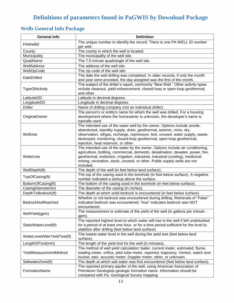
Definitions of parameters found in PaGWIS by Download Package
Wells General Info Package
General Info Definition
PAWellID The unique number to identify the record. There is one PA WELL ID number per well.
County The county in which the well is located.
Municipality The municipality of the well site.
QuadName The 7.5-minute quadrangle of the well site.
WellAddress The address of the well site.
WellZipCode The zip code of the well site.
DateDrilled The date the well drilling was completed. In older records, if only the month and year were provided, the day assigned was the first of the month.
TypeOfActivity The subject of the driller’s report, commonly “New Well.” Other activity types include cleanout, yield enhancement, closed-loop or open-loop geothermal, and other.
LatitudeDD Latitude in decimal degrees.
LongitudeDD Longitude in decimal degrees.
Driller Name of drilling company (not an individual driller).
OriginalOwner The person's or entity's name for whom the well was drilled. For a housing development where the homeowner is unknown, the developer's name is typically used.
WellUse
The intended use of the water well by the owner. Options include anode, abandoned, standby supply, drain, geothermal, seismic, mine, dry, observation, oil/gas, recharge, repressure, test, unused, water supply, waste, destroyed, monitoring, closed-loop geothermal, open-loop geothermal, injection, heat reservoir, or other.
WaterUse
The intended use of the water by the owner. Options include air conditioning, agriculture, bottling, commercial, domestic, desalination, dewater, power, fire, geothermal, institution, irrigation, industrial, industrial (cooling), medicinal, mining, recreation, stock, unused, or other. Public supply wells are not included.
WellDepth(ft) The depth of the well (in feet below land surface).
TopOfCasing(ft) The top of the casing used in the borehole (in feet below surface). A negative number indicated a stickup above the surface.
BottomOfCasing(ft) The bottom of the casing used in the borehole (in feet below surface).
CasingDiameter(in) The diameter of the casing (in inches).
DepthToBedrock(ft) The depth at which solid bedrock is encountered (in feet below surface).
BedrockNotReached Whether or not bedrock was encountered during drilling. Retrievals of "False" indicated bedrock was encountered; "true" indicates bedrock was NOT encountered.
WellYield(gpm) The measurement or estimate of the yield of the well (in gallons per minute - gpm).
StaticWaterLevel(ft) The reported highest level to which water will rise in the well if left undisturbed for a period of at least one hour, or for a time period sufficient for the level to stabilize after drilling (feet below land surface).
WaterLevelAfterYieldTest(ft) The lowest water level in the well during the yield test (feet below land surface).
LengthOfTest(min) The length of the yield test for the well (in minutes).
YieldMeasurementMethod The method of well yield calculation: bailer, current meter, estimated, flume, totaling meter, orifice, pitot tube meter, reported, trajectory, Venturi, watch and bucket, weir, acoustic meter, Doppler meter, other, or unknown.
SaltwaterZone(ft) The depth at which salt water was first encountered (feet below land surface).
FormationName The reported primary aquifer of the well, using American Association of Petroleum Geologists geologic formation name. Information should be compared with Pa. Geological Survey mapping.
14
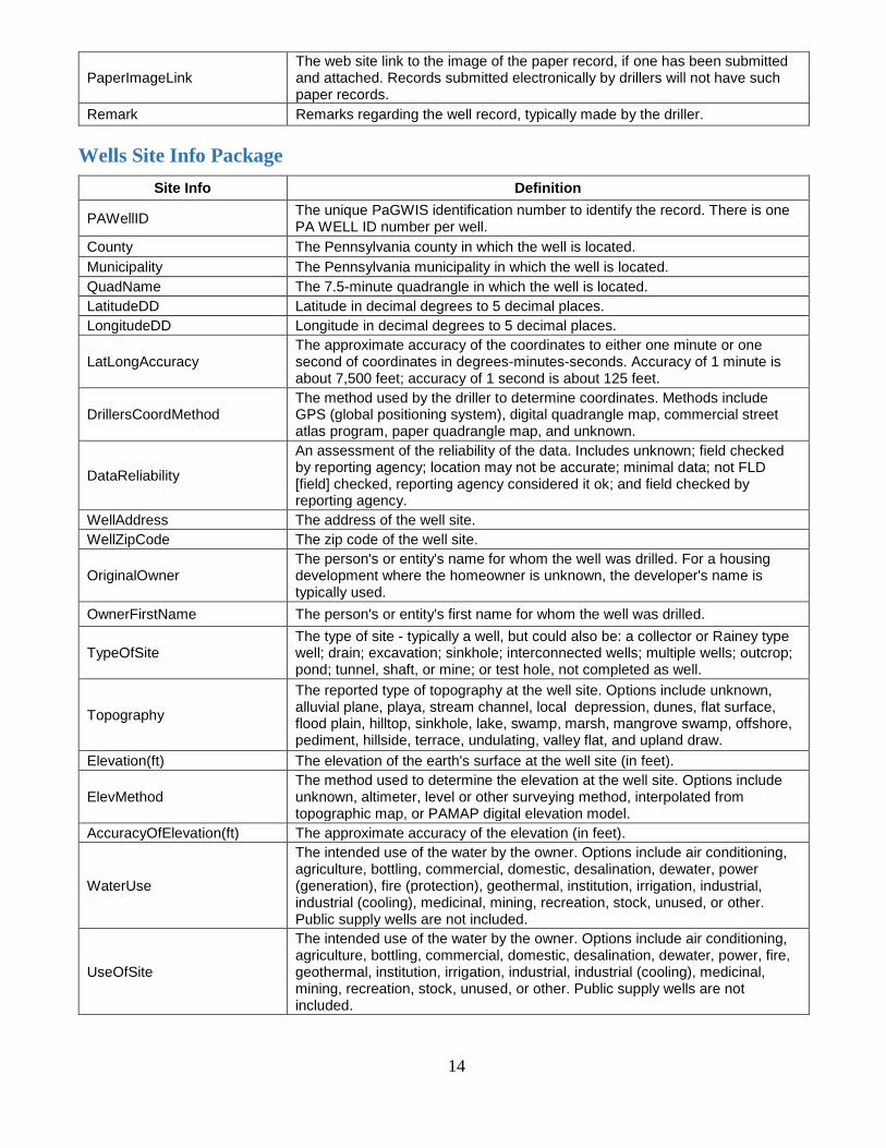
PaperImageLink The web site link to the image of the paper record, if one has been submitted and attached. Records submitted electronically by drillers will not have such paper records.
Remark Remarks regarding the well record, typically made by the driller.
Wells Site Info Package
Site Info Definition
PAWellID The unique PaGWIS identification number to identify the record. There is one PA WELL ID number per well.
County The Pennsylvania county in which the well is located.
Municipality The Pennsylvania municipality in which the well is located.
QuadName The 7.5-minute quadrangle in which the well is located.
LatitudeDD Latitude in decimal degrees to 5 decimal places.
LongitudeDD Longitude in decimal degrees to 5 decimal places.
LatLongAccuracy The approximate accuracy of the coordinates to either one minute or one second of coordinates in degrees-minutes-seconds. Accuracy of 1 minute is about 7,500 feet; accuracy of 1 second is about 125 feet.
DrillersCoordMethod The method used by the driller to determine coordinates. Methods include GPS (global positioning system), digital quadrangle map, commercial street atlas program, paper quadrangle map, and unknown.
DataReliability
An assessment of the reliability of the data. Includes unknown; field checked by reporting agency; location may not be accurate; minimal data; not FLD [field] checked, reporting agency considered it ok; and field checked by reporting agency.
WellAddress The address of the well site.
WellZipCode The zip code of the well site.
OriginalOwner The person's or entity's name for whom the well was drilled. For a housing development where the homeowner is unknown, the developer's name is typically used.
OwnerFirstName The person's or entity's first name for whom the well was drilled.
TypeOfSite The type of site - typically a well, but could also be: a collector or Rainey type well; drain; excavation; sinkhole; interconnected wells; multiple wells; outcrop; pond; tunnel, shaft, or mine; or test hole, not completed as well.
Topography
The reported type of topography at the well site. Options include unknown, alluvial plane, playa, stream channel, local depression, dunes, flat surface, flood plain, hilltop, sinkhole, lake, swamp, marsh, mangrove swamp, offshore, pediment, hillside, terrace, undulating, valley flat, and upland draw.
Elevation(ft) The elevation of the earth's surface at the well site (in feet).
ElevMethod The method used to determine the elevation at the well site. Options include unknown, altimeter, level or other surveying method, interpolated from topographic map, or PAMAP digital elevation model.
AccuracyOfElevation(ft) The approximate accuracy of the elevation (in feet).
WaterUse
The intended use of the water by the owner. Options include air conditioning, agriculture, bottling, commercial, domestic, desalination, dewater, power (generation), fire (protection), geothermal, institution, irrigation, industrial, industrial (cooling), medicinal, mining, recreation, stock, unused, or other. Public supply wells are not included.
UseOfSite
The intended use of the water by the owner. Options include air conditioning, agriculture, bottling, commercial, domestic, desalination, dewater, power, fire, geothermal, institution, irrigation, industrial, industrial (cooling), medicinal, mining, recreation, stock, unused, or other. Public supply wells are not included.

15
SourceOfSiteRecord
Where the information for the record originated. Options include USGS – GWSI (Field Verified sites from the USGS's National Ground Water Site Inventory); PaGS WWI PAPER (Office Located sites using paper version of Water Well Completion Reports supplied by Drillers); PaGS WWI Electronic (Sites from Water Well Completion Reports submitted using the WebDriller Internet application. Locations should be very good); PA Dept Of Agriculture Pesticide Survey (Field verified sites from the Pa. Dept of Agriculture's pesticide survey); PaGS Other Than WWI (Sites located by PaGS staff for which no Water Well Completion Report was available); Susquehanna River Basin Comm (Sites from the databases of the basin commission. Should be quite reliable); Delaware River Basin Comm (Sites from the databases of the basin commission. Should be quite reliable); Ohio River Basin Comm (Sites from the databases of the basin commission. Should be quite reliable); Potomac River Basin Comm (Sites from the databases of the basin commission. Should be quite reliable); EPA (Sites from EPA sources other than STORET. STORET is EPA’s STOage and RETrieval database); Private/Univ Geologist (Consultant) (Sites identified by consultants or academia. Often found in thesis and technical reports, such as site assessments); Water Company (Sites identified by a licensed water purveyor); USGS - Other Than GWSI (Sites from USGS other than GWSI. GWSI is “GroundWater Site Inventory”); Other/Unknown/Unspecified (Source of original site data is unknown or unidentified); EPA STORET (EPA STORET sites which do not originate from one of the other identified sources in this table); PaGS (Sites located by PaGS staff for which a Water Well Completion Report was available).
PaperImageLink The web site link to the scanned paper image for the record.
OtherIdentifier An additional identification number for the well.
OtherIDAssignor The person or organization who assigned the "Other Identifier."
LocalPermit A permit number obtained from a local municipality
RemarkDate The date when the remark field was last entered.
Remark A comment made about the well by the driller or by the Bureau of Topographic and Geologic Survey.
Wells Well Construction Package
Well Construction Definition
PAWellID The unique PaGWIS identification number to identify the record. There is one PA WELL ID number per well.
Driller Name of drilling company (not an individual driller).
Drillers_well_id A unique identification number assigned by the driller. The number is unique only to the particular driller.
ConstructionType
The subject of the driller’s report, commonly “New Well.” Other activity types include cleanout, yield enhancement, closed-loop geothermal, open-loop geothermal, and other. This column is the same as Type of Activity in the General Info download.
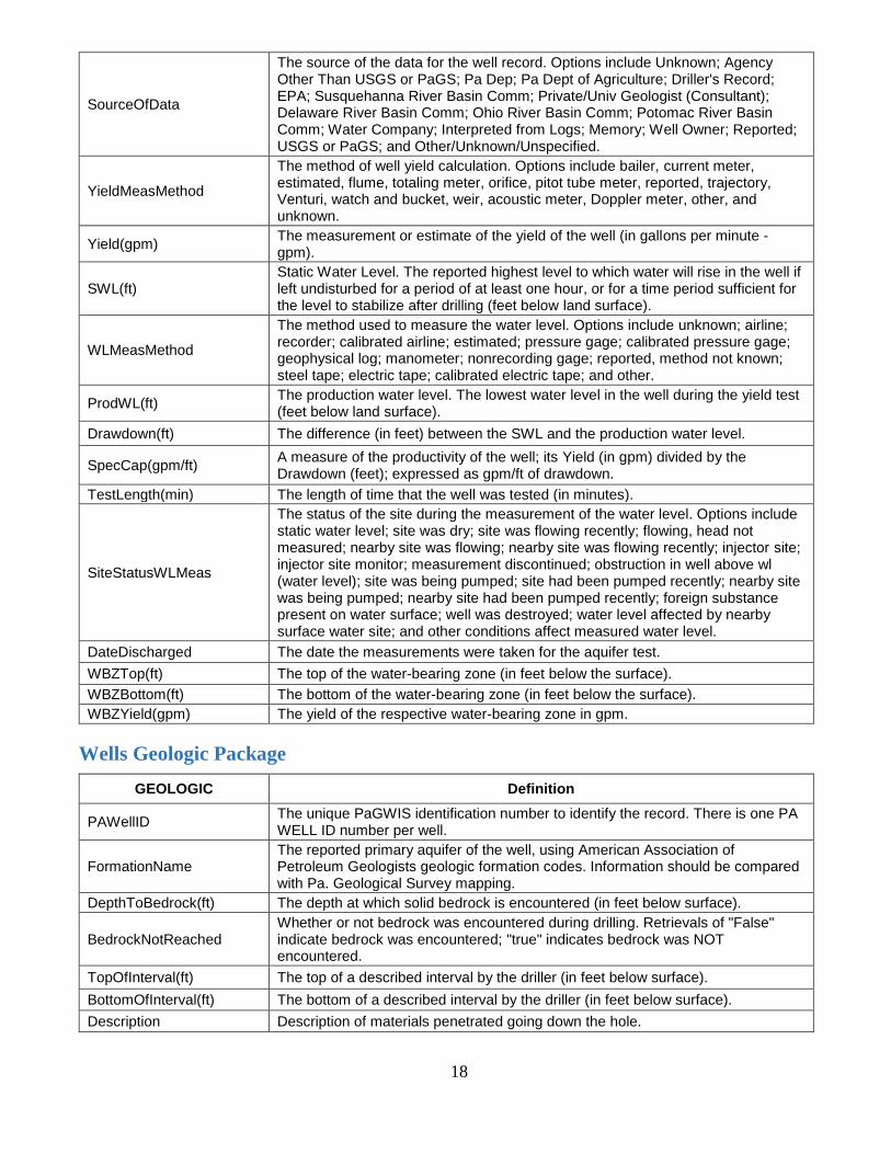
SourceOfData
The source of the data for the well record. Options include Unknown; Agency Other Than USGS or PaGS; Pa Dep; Pa Dept of Agriculture; Driller's Record; EPA; Susquehanna River Basin Comm; Private/Univ Geologist (Consultant); Delaware River Basin Comm; Ohio River Basin Comm; Potomac River Basin Comm; Water Company; Interpreted from Logs; Memory; Well Owner; Reported; USGS or PaGS; and Other/Unknown/Unspecified.
MethodCons The method of well drilling: air rotary, bored or augered, cable tool, dug, hydraulic rotary, jetted, air percussion, reverse rotary, trenching, driven, drive wash, or other.
16
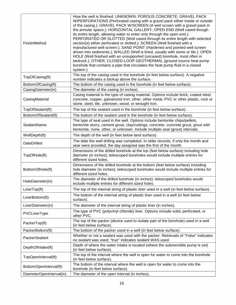
FinishMethod
How the well is finished: UNKNOWN; POROUS CONCRETE; GRAVEL PACK W/PERFORATIONS (Perforated casing with a gravel pack either inside or outside of the casing.); GRAVEL PACK W/SCREEN (A well screen with a gravel pack in the annular space.); HORIZONTAL GALLERY; OPEN END (Well cased though its entire length, allowing water to enter only through the open end.); PERFORATED OR SLOTTED (Well cased through its entire length with selected section(s) either perforated or slotted.); SCREEN (Well finished with a manufactured well screen.); SAND POINT (Hardened and pointed well screen driven into sediments.); WALLED (Well is lined, usually with stone or tile.); OPEN HOLE (Well finished with an unsupported (uncased) borehole, most often in bedrock.); OTHER; CLOSED-LOOP GEOTHERMAL (ground source heat pump borehole that contains a pipe that circulates the heat pump fluid in a closed system.)
TopOfCasing(ft) The top of the casing used in the borehole (in feet below surface). A negative number indicates a stickup above the surface.
BottomOfCasing(ft) The bottom of the casing used in the borehole (in feet below surface).
CasingDiameter(in) The diameter of the casing (in inches).
CasingMaterial Casing material is the type of casing material. Options include brick, coated steel, concrete, copper, galvanized iron, other, other metal, PVC or other plastic, rock or stone, steel, tile, unknown, wood, or wrought iron.
TopOfSealant(ft) The top of the sealant used in the borehole (in feet below surface).
BottomOfSealant(ft) The bottom of the sealant used in the borehole (in feet below surface).
SealantName The type of seal used in the well. Options include bentonite chips/pellets, bentonite slurry, cement grout, clay/cuttings, concrete, concrete grout, grout with bentonite, none, other, or unknown. Include multiple seal (grout) intervals.
WellDepth(ft) The depth of the well (in feet below land surface).
DateDrilled The date the well drilling was completed. In older records, if only the month and year were provided, the day assigned was the first of the month.
TopOfHole(ft) Dimensions of the drilled borehole at the top (feet below surface) including hole diameter (in inches); telescoped boreholes would include multiple entries for different sized holes.
BottomOfHole(ft) Dimensions of the drilled borehole at the bottom (feet below surface) including hole diameter (in inches); telescoped boreholes would include multiple entries for different sized holes.
HoleDiameter(in) The diameter of the drilled borehole (in inches); telescoped boreholes would include multiple entries for different sized holes.
LinerTop(ft) The top of the internal string of plastic liner used in a well (in feet below surface).
LinerBottom(ft) The bottom of the internal string of plastic liner used in a well (in feet below surface).
LinerDiameter(in) The diameter of the internal string of plastic liner (in inches).
PVCLinerType The type of PVC (polyvinyl chloride) liner. Options include solid, perforated, or other PVC.
PackerTop(ft) The top of the packer (device used to isolate part of the borehole) used in a well (in feet below surface).
PackerBottom(ft) The bottom of the packer used in a well (in feet below surface).
PackerSealant Whether or not a sealant was used with the packer. Retrievals of "False" indicates no sealant was used; "true" indicates sealant WAS used.
DepthOfIntake(ft) Depth of where the water intake is located (where the submersible pump is set) (in feet below surface).
TopOpenInterval(ft) The top of the interval where the well is open for water to come into the borehole (in feet below surface).
BottomOpenInterval(ft) The bottom of the interval where the well is open for water to come into the borehole (in feet below surface).
DiameterOpenInterval(in) The diameter of the open interval (in inches)..

17
OpenIntervalMaterial The material of the open interval portion of the well. Options include unknown; brass or bronze; concrete; galvanized iron; wrought iron; other metal; plastic; stainless steel; steel; tile; or other.
TypeOfOpening The type of opening in the borehole. Options include driller reported water bearing zone; fractured rock; louvered screen; mesh screen; perforated, porous, or slotted casing; wire-wound screen; screen; sand point; walled; open hole; and other.
YieldOfInterval(gpm) The measurement or estimate of the yield of the specific open interval of the well (in gallons per minute - gpm).
SlotSize(in) The size of the slot holes in the opening (in inches).
PackingType
The type of packing around the open interval in the well. Options include UNKNOWN; GRAVEL – SCREENED (Gravel of a specified size range); SAND – SCREENED (Sand of a specified size range); GEOTEXTILE (Filter fabric wrapped around screen); GRAVEL – UNSCREENED (Run-of-quarry gravel, of a general size - ex. 2B); NATURAL (In-place formation material was developed as a packing); OTHER (See “Remarks” column for possible additional info; PRE-PACKED (Double walled screen with factory installed packing); SAND – UNSCREENED (Run-of-mine sand, not of a specified size range); or NONE (No known packing material).
AbandonmentReason For an abandoned (decommissioned) well, the reason why the well was decommissioned. Options include Well was unused; Inadequate yield; Poor water quality; or Other.
Wells Hydrogeologic Package
HYDROGEOLOGIC Definition
PAWellID The unique PaGWIS identification number to identify the record. There is one PA WELL ID number per well.
HydrologicUnit The USGS division of surface water boundaries. Refer to USGS Water-Supply Paper 2294 for details.
DepthToSaltwater(ft) The depth at which salt water was first encountered (feet below land surface).
FormationName The reported primary aquifer of the well, using American Association of Petroleum Geologists geologic formation names. Information should be compared with Pa. Geological Survey mapping.
Lithology
Rock or sediment type. Options include unknown; alluvium; anhydrite; anorthosite; arkose; boulders; boulders, silt, and clay; boulders and sand; bentonite; breccia; basalt; carbonolith; conglomerate; chalk; chert; clay; caliche (hard pan); calcite; clay, some sand; claystone; colluvium; coal; cobbles; cobbles, silt, and clay; cobbles and sand; coquina; diabase; dolomite; dolomite and shale; diorite; drift; evaporite; gabbro; glacial (undifferentiated); gneiss; greenstone; gypsum; graywacke; gravel and clay; gravel, cemented; gravel, sand, and silt; granite, gneiss; granite; gravel, silt, and clay; gravel; hard pan; igneous (undifferentiated); lignite; limestone and dolomite; limestone and shale; limestone; loam; loess; marl; mudstone; metamorphic (undifferentiated); marble; marlstone; muck; mud; overburden; other; outwash; peat; quartzite; rubble, barney; rock; residium; rhyolite; sand; schist; sand and clay; sand and gravel; sedimentary (undifferentiated); sandstone and shale; sand and silt; sand, gravel, and clay; shale; silt; siltstone; slate; sand, some clay; sandstone; soil; saprolite; serpentine; silt and clay; syenite; till; travertine; tuff; volcanic (undifferentiated); topsoil; diabase; gravel; other; sand; schist; shale; slate; sandstone; and clay.
ContributingUnit An assessment of the contributing area for a particular lithology of the well. Options include no water; primary; secondary; and unknown.
TopOfInterval(ft) The top of the interval of the contributing unit (in feet below surface).
BottomOfInterval(ft) The bottom of the interval of the contributing unit (in feet below surface).
DischargeType The discharge of the well. Options include unknown; flowing; or pumped.
18
SourceOfData
The source of the data for the well record. Options include Unknown; Agency Other Than USGS or PaGS; Pa Dep; Pa Dept of Agriculture; Driller's Record; EPA; Susquehanna River Basin Comm; Private/Univ Geologist (Consultant); Delaware River Basin Comm; Ohio River Basin Comm; Potomac River Basin Comm; Water Company; Interpreted from Logs; Memory; Well Owner; Reported; USGS or PaGS; and Other/Unknown/Unspecified.
YieldMeasMethod
The method of well yield calculation. Options include bailer, current meter, estimated, flume, totaling meter, orifice, pitot tube meter, reported, trajectory, Venturi, watch and bucket, weir, acoustic meter, Doppler meter, other, and unknown.
Yield(gpm) The measurement or estimate of the yield of the well (in gallons per minute - gpm).
SWL(ft) Static Water Level. The reported highest level to which water will rise in the well if left undisturbed for a period of at least one hour, or for a time period sufficient for the level to stabilize after drilling (feet below land surface).
WLMeasMethod
The method used to measure the water level. Options include unknown; airline; recorder; calibrated airline; estimated; pressure gage; calibrated pressure gage; geophysical log; manometer; nonrecording gage; reported, method not known; steel tape; electric tape; calibrated electric tape; and other.
ProdWL(ft) The production water level. The lowest water level in the well during the yield test (feet below land surface).
Drawdown(ft) The difference (in feet) between the SWL and the production water level.
SpecCap(gpm/ft) A measure of the productivity of the well; its Yield (in gpm) divided by the Drawdown (feet); expressed as gpm/ft of drawdown.
TestLength(min) The length of time that the well was tested (in minutes).
SiteStatusWLMeas
The status of the site during the measurement of the water level. Options include static water level; site was dry; site was flowing recently; flowing, head not measured; nearby site was flowing; nearby site was flowing recently; injector site; injector site monitor; measurement discontinued; obstruction in well above wl (water level); site was being pumped; site had been pumped recently; nearby site was being pumped; nearby site had been pumped recently; foreign substance present on water surface; well was destroyed; water level affected by nearby surface water site; and other conditions affect measured water level.
DateDischarged The date the measurements were taken for the aquifer test.
WBZTop(ft) The top of the water-bearing zone (in feet below the surface).
WBZBottom(ft) The bottom of the water-bearing zone (in feet below the surface).
WBZYield(gpm) The yield of the respective water-bearing zone in gpm.
Wells Geologic Package
GEOLOGIC Definition
PAWellID The unique PaGWIS identification number to identify the record. There is one PA WELL ID number per well.
FormationName The reported primary aquifer of the well, using American Association of Petroleum Geologists geologic formation codes. Information should be compared with Pa. Geological Survey mapping.
DepthToBedrock(ft) The depth at which solid bedrock is encountered (in feet below surface).
BedrockNotReached Whether or not bedrock was encountered during drilling. Retrievals of "False" indicate bedrock was encountered; "true" indicates bedrock was NOT encountered.
TopOfInterval(ft) The top of a described interval by the driller (in feet below surface).
BottomOfInterval(ft) The bottom of a described interval by the driller (in feet below surface).
Description Description of materials penetrated going down the hole.
19
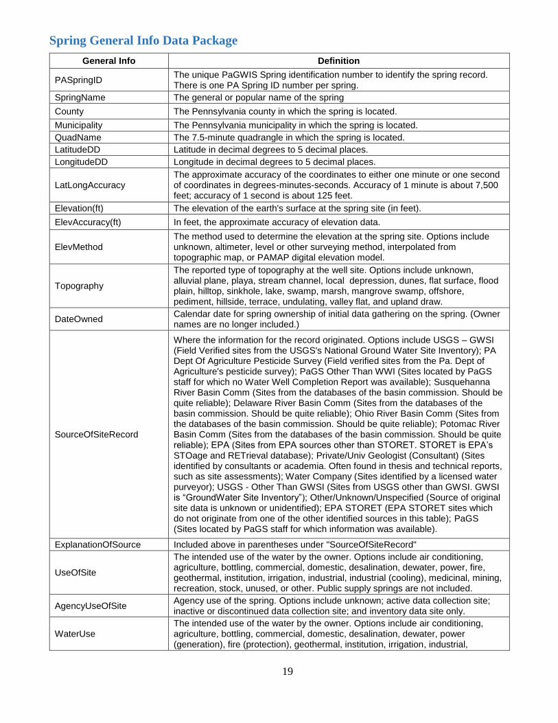
Spring General Info Data Package
General Info Definition
PASpringID The unique PaGWIS Spring identification number to identify the spring record. There is one PA Spring ID number per spring.
SpringName The general or popular name of the spring
County The Pennsylvania county in which the spring is located.
Municipality The Pennsylvania municipality in which the spring is located.
QuadName The 7.5-minute quadrangle in which the spring is located.
LatitudeDD Latitude in decimal degrees to 5 decimal places.
LongitudeDD Longitude in decimal degrees to 5 decimal places.
LatLongAccuracy The approximate accuracy of the coordinates to either one minute or one second of coordinates in degrees-minutes-seconds. Accuracy of 1 minute is about 7,500 feet; accuracy of 1 second is about 125 feet.
Elevation(ft) The elevation of the earth's surface at the spring site (in feet).
ElevAccuracy(ft) In feet, the approximate accuracy of elevation data.
ElevMethod The method used to determine the elevation at the spring site. Options include unknown, altimeter, level or other surveying method, interpolated from topographic map, or PAMAP digital elevation model.
Topography
The reported type of topography at the well site. Options include unknown, alluvial plane, playa, stream channel, local depression, dunes, flat surface, flood plain, hilltop, sinkhole, lake, swamp, marsh, mangrove swamp, offshore, pediment, hillside, terrace, undulating, valley flat, and upland draw.
DateOwned Calendar date for spring ownership of initial data gathering on the spring. (Owner names are no longer included.)
SourceOfSiteRecord
Where the information for the record originated. Options include USGS – GWSI (Field Verified sites from the USGS's National Ground Water Site Inventory); PA Dept Of Agriculture Pesticide Survey (Field verified sites from the Pa. Dept of Agriculture's pesticide survey); PaGS Other Than WWI (Sites located by PaGS staff for which no Water Well Completion Report was available); Susquehanna River Basin Comm (Sites from the databases of the basin commission. Should be quite reliable); Delaware River Basin Comm (Sites from the databases of the basin commission. Should be quite reliable); Ohio River Basin Comm (Sites from the databases of the basin commission. Should be quite reliable); Potomac River Basin Comm (Sites from the databases of the basin commission. Should be quite reliable); EPA (Sites from EPA sources other than STORET. STORET is EPA’s STOage and RETrieval database); Private/Univ Geologist (Consultant) (Sites identified by consultants or academia. Often found in thesis and technical reports, such as site assessments); Water Company (Sites identified by a licensed water purveyor); USGS - Other Than GWSI (Sites from USGS other than GWSI. GWSI is “GroundWater Site Inventory”); Other/Unknown/Unspecified (Source of original site data is unknown or unidentified); EPA STORET (EPA STORET sites which do not originate from one of the other identified sources in this table); PaGS (Sites located by PaGS staff for which information was available).
ExplanationOfSource Included above in parentheses under "SourceOfSiteRecord"
UseOfSite
The intended use of the water by the owner. Options include air conditioning, agriculture, bottling, commercial, domestic, desalination, dewater, power, fire, geothermal, institution, irrigation, industrial, industrial (cooling), medicinal, mining, recreation, stock, unused, or other. Public supply springs are not included.
AgencyUseOfSite Agency use of the spring. Options include unknown; active data collection site; inactive or discontinued data collection site; and inventory data site only.
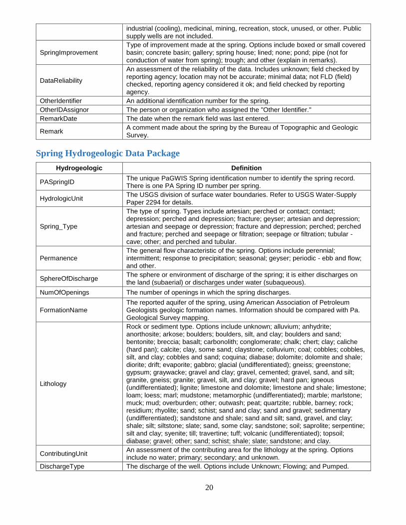
WaterUse The intended use of the water by the owner. Options include air conditioning, agriculture, bottling, commercial, domestic, desalination, dewater, power (generation), fire (protection), geothermal, institution, irrigation, industrial,
20
industrial (cooling), medicinal, mining, recreation, stock, unused, or other. Public supply wells are not included.
SpringImprovement Type of improvement made at the spring. Options include boxed or small covered basin; concrete basin; gallery; spring house; lined; none; pond; pipe (not for conduction of water from spring); trough; and other (explain in remarks).
DataReliability
An assessment of the reliability of the data. Includes unknown; field checked by reporting agency; location may not be accurate; minimal data; not FLD (field) checked, reporting agency considered it ok; and field checked by reporting agency.
OtherIdentifier An additional identification number for the spring.
OtherIDAssignor The person or organization who assigned the "Other Identifier."
RemarkDate The date when the remark field was last entered.
Remark A comment made about the spring by the Bureau of Topographic and Geologic Survey.
Spring Hydrogeologic Data Package
Hydrogeologic Definition
PASpringID The unique PaGWIS Spring identification number to identify the spring record. There is one PA Spring ID number per spring.
HydrologicUnit The USGS division of surface water boundaries. Refer to USGS Water-Supply Paper 2294 for details.
Spring_Type
The type of spring. Types include artesian; perched or contact; contact; depression; perched and depression; fracture; geyser; artesian and depression; artesian and seepage or depression; fracture and depression; perched; perched and fracture; perched and seepage or filtration; seepage or filtration; tubular - cave; other; and perched and tubular.
Permanence The general flow characteristic of the spring. Options include perennial; intermittent; response to precipitation; seasonal; geyser; periodic - ebb and flow; and other.
SphereOfDischarge The sphere or environment of discharge of the spring; it is either discharges on the land (subaerial) or discharges under water (subaqueous).
NumOfOpenings The number of openings in which the spring discharges.
FormationName The reported aquifer of the spring, using American Association of Petroleum Geologists geologic formation names. Information should be compared with Pa. Geological Survey mapping.
Lithology
Rock or sediment type. Options include unknown; alluvium; anhydrite; anorthosite; arkose; boulders; boulders, silt, and clay; boulders and sand; bentonite; breccia; basalt; carbonolith; conglomerate; chalk; chert; clay; caliche (hard pan); calcite; clay, some sand; claystone; colluvium; coal; cobbles; cobbles, silt, and clay; cobbles and sand; coquina; diabase; dolomite; dolomite and shale; diorite; drift; evaporite; gabbro; glacial (undifferentiated); gneiss; greenstone; gypsum; graywacke; gravel and clay; gravel, cemented; gravel, sand, and silt; granite, gneiss; granite; gravel, silt, and clay; gravel; hard pan; igneous (undifferentiated); lignite; limestone and dolomite; limestone and shale; limestone; loam; loess; marl; mudstone; metamorphic (undifferentiated); marble; marlstone; muck; mud; overburden; other; outwash; peat; quartzite; rubble, barney; rock; residium; rhyolite; sand; schist; sand and clay; sand and gravel; sedimentary (undifferentiated); sandstone and shale; sand and silt; sand, gravel, and clay; shale; silt; siltstone; slate; sand, some clay; sandstone; soil; saprolite; serpentine; silt and clay; syenite; till; travertine; tuff; volcanic (undifferentiated); topsoil; diabase; gravel; other; sand; schist; shale; slate; sandstone; and clay.
ContributingUnit An assessment of the contributing area for the lithology at the spring. Options include no water; primary; secondary; and unknown.
DischargeType The discharge of the well. Options include Unknown; Flowing; and Pumped.
21
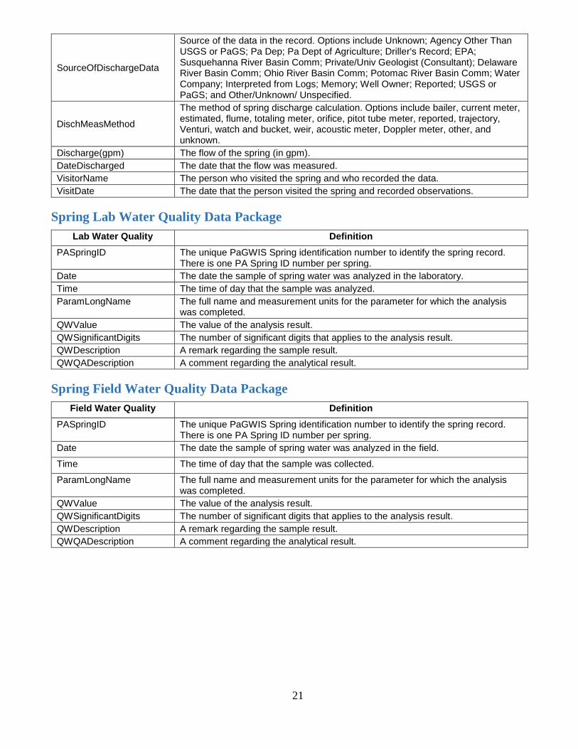
SourceOfDischargeData
Source of the data in the record. Options include Unknown; Agency Other Than USGS or PaGS; Pa Dep; Pa Dept of Agriculture; Driller's Record; EPA; Susquehanna River Basin Comm; Private/Univ Geologist (Consultant); Delaware River Basin Comm; Ohio River Basin Comm; Potomac River Basin Comm; Water Company; Interpreted from Logs; Memory; Well Owner; Reported; USGS or PaGS; and Other/Unknown/ Unspecified.
DischMeasMethod
The method of spring discharge calculation. Options include bailer, current meter, estimated, flume, totaling meter, orifice, pitot tube meter, reported, trajectory, Venturi, watch and bucket, weir, acoustic meter, Doppler meter, other, and unknown.
Discharge(gpm) The flow of the spring (in gpm).
DateDischarged The date that the flow was measured.
VisitorName The person who visited the spring and who recorded the data.
VisitDate The date that the person visited the spring and recorded observations.
Spring Lab Water Quality Data Package
Lab Water Quality Definition
PASpringID The unique PaGWIS Spring identification number to identify the spring record. There is one PA Spring ID number per spring.
Date The date the sample of spring water was analyzed in the laboratory.
Time The time of day that the sample was analyzed.
ParamLongName The full name and measurement units for the parameter for which the analysis was completed.
QWValue The value of the analysis result.
QWSignificantDigits The number of significant digits that applies to the analysis result.
QWDescription A remark regarding the sample result.
QWQADescription A comment regarding the analytical result.
Spring Field Water Quality Data Package
Field Water Quality Definition
PASpringID The unique PaGWIS Spring identification number to identify the spring record. There is one PA Spring ID number per spring.
Date The date the sample of spring water was analyzed in the field.
Time The time of day that the sample was collected.
ParamLongName The full name and measurement units for the parameter for which the analysis was completed.
QWValue The value of the analysis result.
QWSignificantDigits The number of significant digits that applies to the analysis result.
QWDescription A remark regarding the sample result.
QWQADescription A comment regarding the analytical result.