Embed Size (px)
DESCRIPTION
A brochure explaning the Philadelphia Zoning Code Commission's Zoning Map Revision Plan, a comprehensive plan for updating the City's official zoning map, and how it relates to the Commission's overall zoning reform effort.
Citation preview
Prepared by The Philadelphia Zoning Code Commission, May 2011 | www.zoningmatters.org1.
Zoning Map Revision Plan
A Guide to Understanding the
of the Philadelphia City Planning and Zoning Code Commissions
In May 2007, Philadelphia voters over-whelmingly approved an amendment to the City of Philadelphia Home Rule Charter to create a Zoning Code Commission (ZCC) to reform and modernize Philadelphia’s outdated and complex zoning code. After four years of dedicated work, the ZCC sent its Zoning Code Proposals to City Council in May 2011.
The ZCC has also prepared a draft Zoning Map Revision Plan outlining a two-step process for updating the City’s official zon-ing map:
1 Conversion2 Re-Mapping
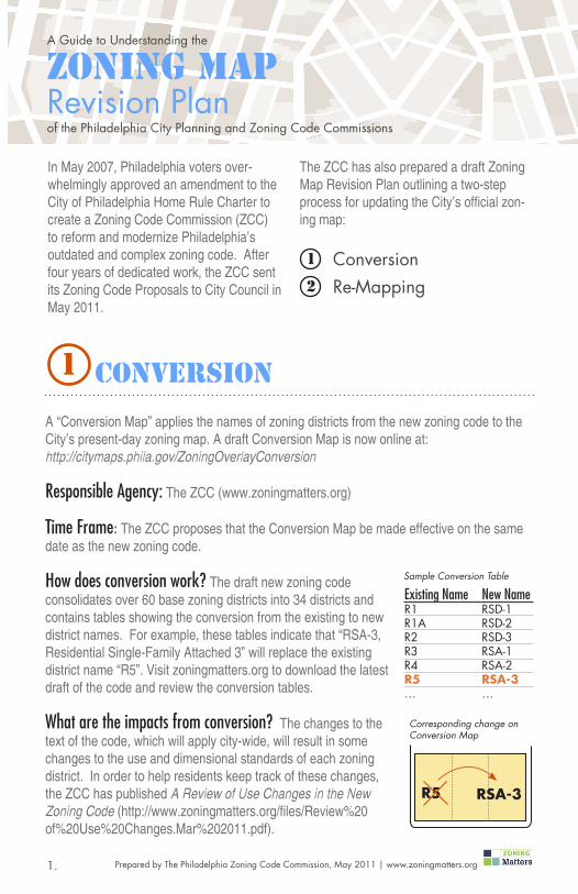
A “Conversion Map” applies the names of zoning districts from the new zoning code to the City’s present-day zoning map. A draft Conversion Map is now online at: http://citymaps.phila.gov/ZoningOverlayConversion
Responsible Agency: The ZCC (www.zoningmatters.org)
Time Frame: The ZCC proposes that the Conversion Map be made effective on the same date as the new zoning code.
How does conversion work? The draft new zoning code consolidates over 60 base zoning districts into 34 districts and contains tables showing the conversion from the existing to new district names. For example, these tables indicate that “RSA-3, Residential Single-Family Attached 3” will replace the existing district name “R5”. Visit zoningmatters.org to download the latest draft of the code and review the conversion tables.
What are the impacts from conversion? The changes to the text of the code, which will apply city-wide, will result in some changes to the use and dimensional standards of each zoning district. In order to help residents keep track of these changes, the ZCC has published A Review of Use Changes in the New Zoning Code (http://www.zoningmatters.org/files/Review%20of%20Use%20Changes.Mar%202011.pdf).
R5 RSA-3
Corresponding change on Conversion Map
Existing Name New NameR1 RSD-1R1A RSD-2R2 RSD-3R3 RSA-1R4 RSA-2R5 RSA-3… …
Sample Conversion Table
1 CONVERSION

Prepared by The Philadelphia Zoning Code Commission, May 2011 | www.zoningmatters.org2.
Fall 2011
2012
2013
2014
2015
Spring 2016
Upper Far Northeast
Lower Far Northeast
Central Northeast
Upper North
Upper Northwest
Lower Northwest
River Wards
Lower North
Lower Northeast
North Delaware
North
CentralUniversity/Southwest
West
South
Lower Southwest
West Park
Lower South
Over time, changes in land use may require a “re-mapping”, or a change to a property’s zoning district classification. The Philadel-phia City Planning Commis-sion’s (PCPC) comprehensive planning process will identify re-mapping needs.
Responsible Agency: The PCPC (www.philaplanning.org)
Time Frame: Ongoing 5-year cycle for planning districts. Zoning map revisions will fol-low by City Council ordinance.
How does re-mapping work? The PCPC man-ages Philadelphia 2035: The Comprehensive Plan, a comprehensive planning process comprised of a city-wide vision and 18 district plans. The process will complete four district plans per year over a five-year cycle. The first two district plans begin June 2011.
Each district plan results in land use recommendations that will identify re-mapping needs. After each plan, the PCPC prepares re-mapping ordinances for action by City Council. The PCPC conducts substantial public outreach so citizens can guide the plan, and additional civic engagement for any requisite re-mappings.
When is remapping necessary?
Corrective: To match zoning with existing land use.
Visioning: Apply zoning to encourage new development and uses envisioned by the community through the planning process.
2 RE-MAPPING

Prepared by The Philadelphia Zoning Code Commission, May 2011 | www.zoningmatters.org3.
A RE-MAPPING ExampleHunting Park West Industrial AreaIn September 2010, the PCPC published The Hunting Park West Industrial Area Study, an exemplary report containing the standard components of a district plan, including planning goals and objectives, an exist-ing conditions summary, and land use and zoning recom-mendations.
The study recommends several zoning changes to implement the vision and land use plan for the 400-acre historical industrial area. The following examples highlight two re-mapping recommendations.
Study Area
Henry A
venue
Robe
rts A
venu
e
1
1
ALLEGENY WEST
Wissahickon Avenue
EAST FALLS
SOUTHWESTGERMANTOWN
Huntin
g Pa
rk A
venu
e
Fox St
B
A
A Corrective Re-Mapping
VisioningRe-Mapping
Corrective Re-Mapping
B VisioningRe-Mapping
On Roberts Avenue between King Street and Wissahickon Avenue is a block of two-story single-family rowhouses, however, the present zoning is a multi-family designation (R10). The study recommends re-mapping this district to R10A, a single-family rowhouse designa-tion, to preserve the existing residential character of the block.
Corrective Re-MappingA
Wissahickon Ave.Roberts Ave.
King St.
R10A Zoning Example
R10A allows single-family, attached devel-opment up to three stories in height.
Existing Two-Story Housing

Prepared by The Philadelphia Zoning Code Commission, May 2011 | www.zoningmatters.org4.
A RE-MAPPING ExampleHunting Park West Industrial Area
VisioningBThe Hunting Park West Industrial Area Study identifies the former Eastern Pennsylvania Psychiatric Institute (EPPI) along Henry Avenue as an infill development opportunity. One alterna-tive from the study envisions Henry Avenue as a mixed-use development corridor. The cur-rent zoning for this site is R9A, a single-family rowhouse classification. In order to implement this vision for Henry Avenue, the study recommends re-mapping the former EPPI site to C3, a medium-density commercial mixed-use district.
Existing Zoning
The R9A districts permits single-family and civic/institutional uses (such as schools, libraries, and recreation centers) in three-story detached, semi-detached, and attached buildings.
Proposed Zoning
The C3 dimensional standards enable the construction of mid-rise buildings that may be used for residential, institutional, retail or com-mercial purposes.
Questions? Contact us at [email protected]