Embed Size (px)
Citation preview
A gravitational spreading origin for the Socompa debris avalanche
B. van Wyk de Vriesa,*, S. Self²,1, P.W. Francisc,2, L. Keszthelyid
aMagmas et Volcans (UMR 6524), Observatoire du Physique du Globe, Universite Blaise Pascal, 5 rue Kessler, 63038 Clermont-Ferrand,
FrancebSOEST, University of Hawai'i, 2525 Correa Road, Honolulu, HI 96822 USA
cDepartment of Earth Sciences, The Open University, Walton Hall, Milton Keynes, MK7 6AA, UKdPlanetary Image Research Laboratory, Lunar and Planetary Laboratory, University of Arizona, Tucson, AZ 85721, USA
Received 21 January 2000; accepted 29 July 2000
Abstract
Socompa Volcano arguably provides the world's best-exposed example of a sector collapse-derived debris avalanche
deposit. New observations lead us to re-interpret the origin of the sector collapse. We show that it was triggered by failure
of active thrust-anticlines in sediments and ignimbrites underlying the volcano. The thrust-anticlines were a result of gravita-
tional spreading of substrata under the volcano load. About 80% of the resulting avalanche deposit is composed of substrata
formerly residing under the volcano and in the anticlines. The collapse scar can be traced up to 5 km from the edi®ce, truncating
two spreading-related anticlines, which collapsed in the event. Outcrops near the volcano preserve evidence of edi®ce material
being carried along on top of mobilised substrata. On the north side of the scar, the avalanche motion was initially at right angles
to the failure edge. Structural relations indicate that immediately prior to collapse the substrata disintegrated, became effec-
tively liquidised, and were ejected from beneath the edi®ce. Catastrophic mobilisation of substrata probably resulted from
breakdown of ignimbrite clasts and cement. It may have occurred through progressive rock fracture by high shear strain during
spreading. Material ejected from under Socompa formed a layer on which volcanic edi®ce debris was transported. This
interpretation of events explains the puzzling observation that avalanche units with the lowest gravitational potential energy
moved the furthest. It can also account for avalanche motion normal to the collapse scar walls. Ignimbrites and other rock types
probably capable of similar behaviour underlie many other volcanoes. Identi®cation of spreading at other sites could therefore
be a ®rst step towards assessment of the potential for this style of catastrophic sector collapse. q 2001 Elsevier Science B.V. All
rights reserved.
Keywords: Socompa; sector; collapse; spreading; debris; avalanche
1. Introduction
1.1. Description of Socompa volcano and its
avalanche
Socompa Volcano (Fig. 1) has one of the most
voluminous terrestrial sector collapses and avalanche
deposits and is remarkably well preserved by the
hyper-arid climate of the Atacama Desert of northern
Chile (Fig. 2). The deposit's freshness provides an
Journal of Volcanology and Geothermal Research 105 (2001) 225±247
0377-0273/01/$ - see front matter q 2001 Elsevier Science B.V. All rights reserved.
PII: S0377-0273(00)00252-3
www.elsevier.nl/locate/jvolgeores
* Corresponding author. Tel: 133-04-73-346732; fax: 133-04-
73-346744.
E-mail addresses: [email protected] (B. van
Wyk de Vries), [email protected] (S. Self),
[email protected] (L. Keszthelyi).1 Tel.: 11-808-956-5996; fax: 11-808-956-2538.² P.W. Francis died on 30 October 1999.
excellent opportunity to study the causes and conse-
quences of large-scale sector collapse. The collapse
scar is a wedge, 12 km-wide at its mouth and ,300 m
deep (Fig. 3). The avalanche deposit has a volume of
36 km3, of which 11 km3 are toreva (Reiche, 1937)
blocks (volumes from Wadge et al., 1995), standing in
the mouth of the collapse scar. The majority of the
avalanche deposit is made up of ignimbrites and grav-
els that were laid down before Socompa was formed.
The remaining volume is composed of a veneer of
volcanic rocks from Socompa and some lacustrine
and evaporite salar deposits (Ramirez, 1988; Wadge
et al., 1995). The Socompa avalanche deposit covers
almost 500 km2. The excellent preservation allows the
full complexity of the deposit to be examined. Field
studies have been greatly aided by the recent increase
in road accessibility.
Initially, the Socompa avalanche deposits were
interpreted as the product of a large eruption and pyro-
clastic ¯ow due to the high proportion of pumiceous
material present (Deruelle, 1978). Subsequently, the
feature was recognised as a sector collapse and debris
avalanche deposit (Francis et al., 1985). Initial inter-
pretations of the collapse assumed that it was the
result of a Mt. St. Helens-style lateral blast (Ramirez,
1988). However, the recognition that a large portion
of the avalanche material is from below the volcano
(Deruelle's pumiceous material), and the observation
of sharp topographic changes near the volcano, shifted
the emphasis from explosive failure to gravitational
collapse. The suggestion that the avalanche was due to
failure over a normal fault (Francis and Self, 1985)
was followed up by Wadge et al. (1995), who
concluded that failure in the sub-volcanic sloping
strata caused the collapse.
We have combined new ®eld studies with recent
ideas about the relationship between gravitational
spreading and sector collapse (van Wyk de Vries
and Francis, 1997) to reinterpret the formation of
the Socompa avalanche. Due to the overwhelming
abundance of pre-Socompa volcano material in the
avalanche deposit, we now consider the role of the
B. van Wyk de Vries et al. / Journal of Volcanology and Geothermal Research 105 (2001) 225±247226
a
Sc Sc Sc
tt t
ss
b
p
300m 400m
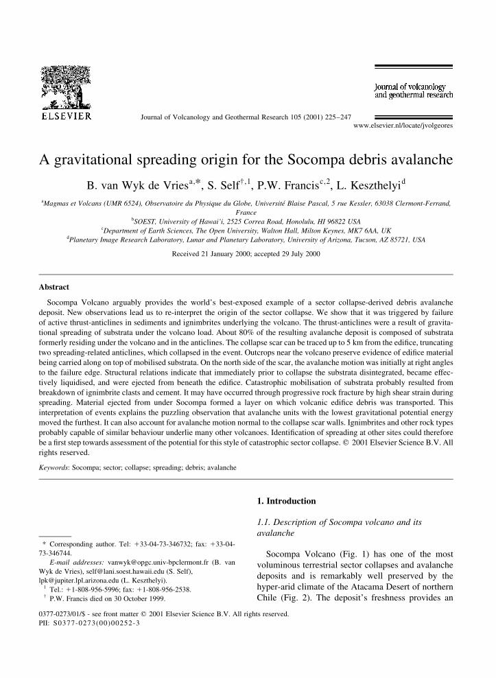
Fig. 1. View of Socompa volcano from west (point X in Fig. 4), standing on the secondary scarp and looking directly at the scar. The left side of
the scar (Sc) is outlined by white pumice. A scale bar is provide on either side of the scar. In the centre of the scar post-collapse lavas mantle
ªDomo del Nucleoº, a light coloured area of original cone. Below this are toreva blocks (t). Viewer is looking up a light coloured debris ¯ow
lineation, composed of substratum material, with a thin veneer of Socompa debris. Fault scarps dipping toward viewer expose lower cushion of
substratum material, which we call reconstituted ignimbrite facies (RIF). A dark point, covered by RIF, on the mid-left is an outlying Negrillar
lava ¯ow (point a). Point s indicates substrata outcrop at base of toreva blocks, and b Lomas de Pajonales ridge. p indicates ®gure of Steve Self
at base of secondary scarp. There is about 3000 m of elevation difference between summit and view point, and the scar mouth is about 12 km
wide.
underlying material to be dominant in the interaction
between volcano and basement, as opposed to volca-
nic activity being the primary cause for the collapse.
We present new ®eld observations suggesting a model
where extrusion of the strata from beneath the volcano
generated thrusts and anticlines, which created the
conditions necessary for sector collapse to occur.
We also present additional ®eld observations that
lead us to conclude that the Socompa avalanche
occurred by catastrophic ejection of liquidised mate-
rials from beneath the volcanic edi®ce.
2. Data presentation
2.1. Geological setting
Socompa Volcano lies at the south±eastern end of
the Atacama Basin, where the Puna Block meets
Cordon de Lila and Sierra Almeida (Figs. 2 and 3).
Although there are large topographic features in the
vicinity of Socompa, there are no recognised regional-
scale tectonic structures, such as faults (Reutter et al.,
1994). The west and northwest ¯anks of the volcano
face the broad Monturaqui Valley, which lies at about
3200 m a.s.l. The southeast ¯anks slope down to a
basin around 3400 m a.s.l, containing the Laguna
Socompa (Fig. 2). The other ¯anks slope down to
other volcanoes of the western volcanic chain, such
as Cerro Pajonales (5950 m), Salin (6000 m), Cerro
B. van Wyk de Vries et al. / Journal of Volcanology and Geothermal Research 105 (2001) 225±247 227
MonturaquiPampade Pomez
Socompa
1
2
3
4
S
TC
Pajonales
Salin
v
v
vv
vv
v
v
v
vv
v
v
v
v
vv
v
v
v
v
v v
El Cenizal
Sierra
Almeida
Cord
on
deLila limit of TM image
15 kmold valley side
Fig. 3. Map and Landsat TM image of Socompa, showing local
structural and topographic features and major components of debris
avalanche. Encircled letters denote: C, Collapse scar; T, toreva
blocks; S, secondary scarp. Orientation of debris streams on either
side of secondary scarp are shown by the dotted lines. The Montur-
aqui unit of avalanche (Wadge et al., 1995) is white, while El
Cenizal unit is shaded. Lavas of the Negrillar ®eld are indicated
by v. Encircled numbers indicate deformation areas discussed in the
text (Section 5.5).
Chi
le
Arge
ntin
a
Bolivia
Socompa
Socompa
Monturaquibasin
Laguna Socompa
Puna Block
Pajonales
2500
3500
(3400 m)
(6100 m)
(~4500 m)
Atacama (~2000 m)
50˚
40˚
20˚
30˚
80˚ 75˚
15˚
13˚
50 km
a b
Palaeo-valley
Cor
don
deLil
a
Sra. Alm
eida
Fig. 2. Location of Socompa. (a) location of Socompa in South
America; (b) Major topographic, geographic and structural features
around Socompa. Over 4000 m the relief is darkly shaded and
contours are every 1000 m. The extent of the Monturaqui Basin is
indicated by light shading. Thrust and normal faults shown are part
of the Socompa±Chiliques spreading system described by van Wyk
de Vries and Borgia (1996). Dotted line through Socompa indicates
approximate trace of broad valley probably existing prior to the
volcano.
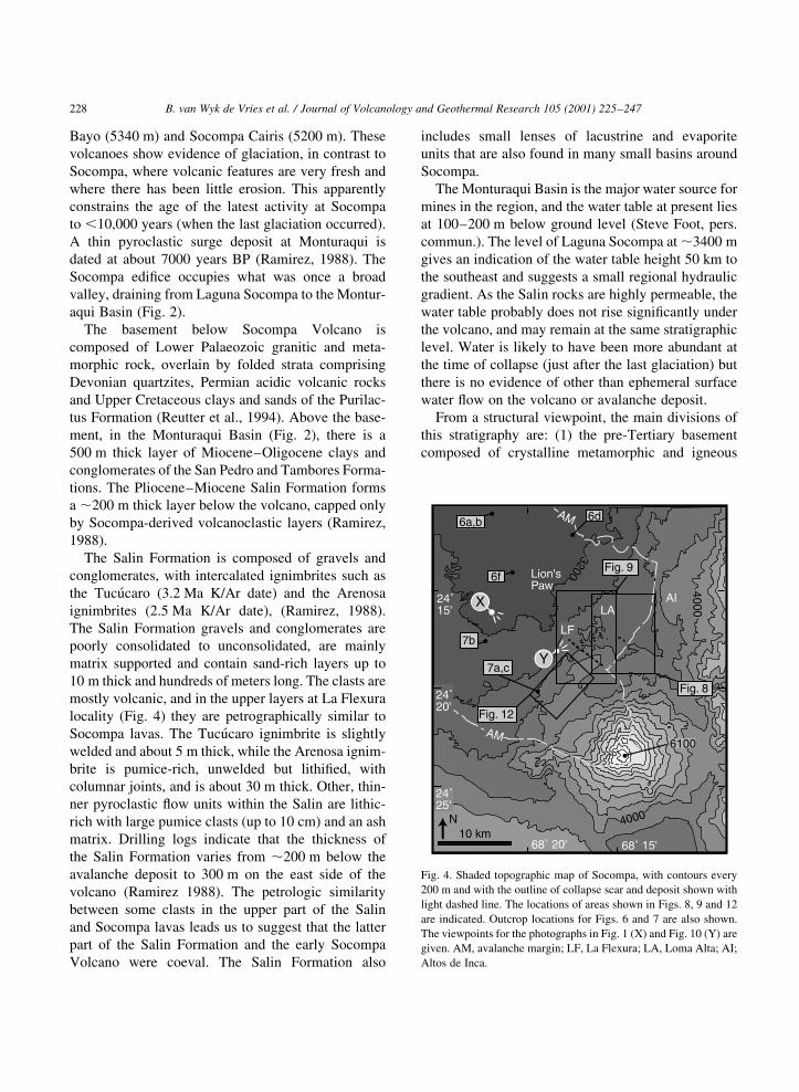
Bayo (5340 m) and Socompa Cairis (5200 m). These
volcanoes show evidence of glaciation, in contrast to
Socompa, where volcanic features are very fresh and
where there has been little erosion. This apparently
constrains the age of the latest activity at Socompa
to ,10,000 years (when the last glaciation occurred).
A thin pyroclastic surge deposit at Monturaqui is
dated at about 7000 years BP (Ramirez, 1988). The
Socompa edi®ce occupies what was once a broad
valley, draining from Laguna Socompa to the Montur-
aqui Basin (Fig. 2).
The basement below Socompa Volcano is
composed of Lower Palaeozoic granitic and meta-
morphic rock, overlain by folded strata comprising
Devonian quartzites, Permian acidic volcanic rocks
and Upper Cretaceous clays and sands of the Purilac-
tus Formation (Reutter et al., 1994). Above the base-
ment, in the Monturaqui Basin (Fig. 2), there is a
500 m thick layer of Miocene±Oligocene clays and
conglomerates of the San Pedro and Tambores Forma-
tions. The Pliocene±Miocene Salin Formation forms
a ,200 m thick layer below the volcano, capped only
by Socompa-derived volcanoclastic layers (Ramirez,
1988).
The Salin Formation is composed of gravels and
conglomerates, with intercalated ignimbrites such as
the TucuÂcaro (3.2 Ma K/Ar date) and the Arenosa
ignimbrites (2.5 Ma K/Ar date), (Ramirez, 1988).
The Salin Formation gravels and conglomerates are
poorly consolidated to unconsolidated, are mainly
matrix supported and contain sand-rich layers up to
10 m thick and hundreds of meters long. The clasts are
mostly volcanic, and in the upper layers at La Flexura
locality (Fig. 4) they are petrographically similar to
Socompa lavas. The TucuÂcaro ignimbrite is slightly
welded and about 5 m thick, while the Arenosa ignim-
brite is pumice-rich, unwelded but lithi®ed, with
columnar joints, and is about 30 m thick. Other, thin-
ner pyroclastic ¯ow units within the Salin are lithic-
rich with large pumice clasts (up to 10 cm) and an ash
matrix. Drilling logs indicate that the thickness of
the Salin Formation varies from ,200 m below the
avalanche deposit to 300 m on the east side of the
volcano (Ramirez 1988). The petrologic similarity
between some clasts in the upper part of the Salin
and Socompa lavas leads us to suggest that the latter
part of the Salin Formation and the early Socompa
Volcano were coeval. The Salin Formation also
includes small lenses of lacustrine and evaporite
units that are also found in many small basins around
Socompa.
The Monturaqui Basin is the major water source for
mines in the region, and the water table at present lies
at 100±200 m below ground level (Steve Foot, pers.
commun.). The level of Laguna Socompa at ,3400 m
gives an indication of the water table height 50 km to
the southeast and suggests a small regional hydraulic
gradient. As the Salin rocks are highly permeable, the
water table probably does not rise signi®cantly under
the volcano, and may remain at the same stratigraphic
level. Water is likely to have been more abundant at
the time of collapse (just after the last glaciation) but
there is no evidence of other than ephemeral surface
water ¯ow on the volcano or avalanche deposit.
From a structural viewpoint, the main divisions of
this stratigraphy are: (1) the pre-Tertiary basement
composed of crystalline metamorphic and igneous
B. van Wyk de Vries et al. / Journal of Volcanology and Geothermal Research 105 (2001) 225±247228
68˚ 20' 68˚ 15'
24˚15'
4000
4000
3200
24˚20'
LAAI
Lion'sPaw
10 kmN
Y7a,c
7b
6a,b 6d
6f
LF
6100
Fig. 8
Fig. 9
Fig. 12
X
AM
AM
24˚25'
Fig. 4. Shaded topographic map of Socompa, with contours every
200 m and with the outline of collapse scar and deposit shown with
light dashed line. The locations of areas shown in Figs. 8, 9 and 12
are indicated. Outcrop locations for Figs. 6 and 7 are also shown.
The viewpoints for the photographs in Fig. 1 (X) and Fig. 10 (Y) are
given. AM, avalanche margin; LF, La Flexura; LA, Loma Alta; AI;
Altos de Inca.
rocks; and (2) about 700 m thickness of Tertiary±
Quaternary sedimentary and pyroclastic materials.
The crystalline rocks are unlikely to have deformed
signi®cantly, but the largely unconsolidated Tertiary
sequence and Oligocene±Miocene clays are not likely
to be able to support the Socompa edi®ce load (van
Wyk de Vries and Borgia, 1996).
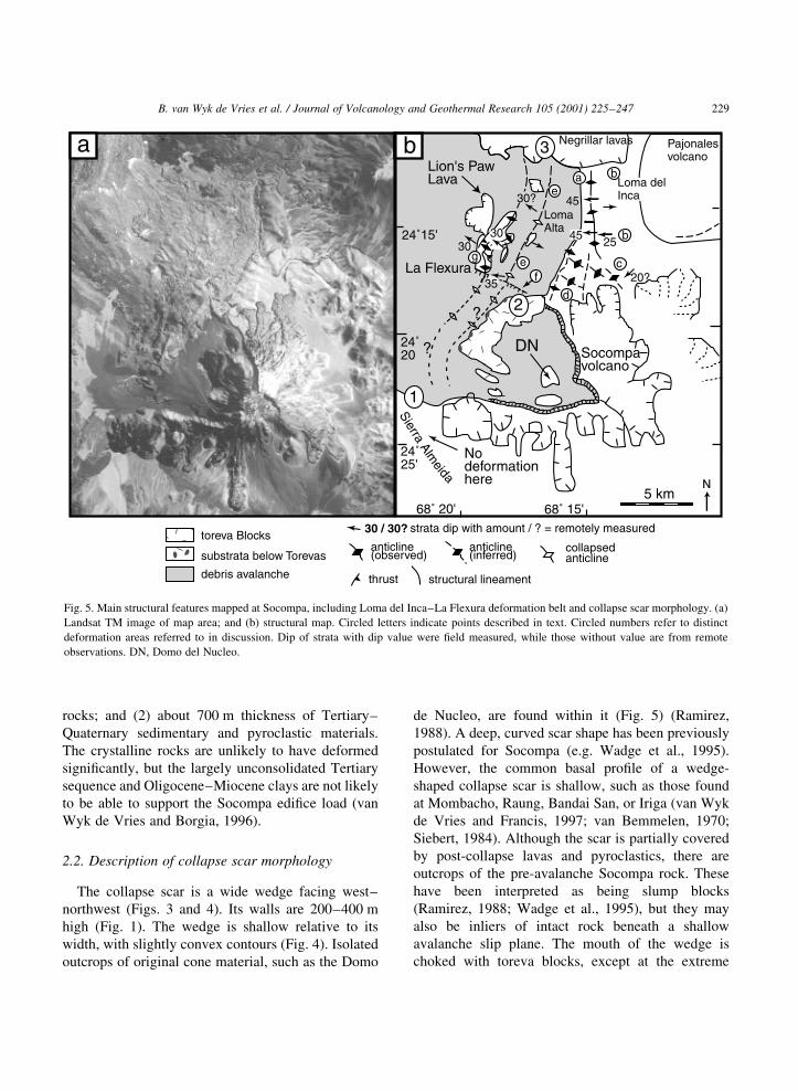
2.2. Description of collapse scar morphology
The collapse scar is a wide wedge facing west±
northwest (Figs. 3 and 4). Its walls are 200±400 m
high (Fig. 1). The wedge is shallow relative to its
width, with slightly convex contours (Fig. 4). Isolated
outcrops of original cone material, such as the Domo
de Nucleo, are found within it (Fig. 5) (Ramirez,
1988). A deep, curved scar shape has been previously
postulated for Socompa (e.g. Wadge et al., 1995).
However, the common basal pro®le of a wedge-
shaped collapse scar is shallow, such as those found
at Mombacho, Raung, Bandai San, or Iriga (van Wyk
de Vries and Francis, 1997; van Bemmelen, 1970;
Siebert, 1984). Although the scar is partially covered
by post-collapse lavas and pyroclastics, there are
outcrops of the pre-avalanche Socompa rock. These
have been interpreted as being slump blocks
(Ramirez, 1988; Wadge et al., 1995), but they may
also be inliers of intact rock beneath a shallow
avalanche slip plane. The mouth of the wedge is
choked with toreva blocks, except at the extreme
B. van Wyk de Vries et al. / Journal of Volcanology and Geothermal Research 105 (2001) 225±247 229
strata dip with amount / ? = remotely measured
thrust
anticline(observed)
anticline(inferred)
structural lineament
collapsedanticline
Loma delInca
La Flexura
Pajonalesvolcano
LomaAlta
N5 km
Lion's PawLava
Socompavolcano
Negrillar lavas
25
45
20?35
30
30 / 30?
30
30?
45
e
ae
f
b
b
c
d
g
Nodeformationhere
toreva Blocks
substrata below Torevas
debris avalanche
1
2
3
DN
b
68˚ 20' 68˚ 15'
24˚25'
24˚15'
24˚20
a
?
?
SierraAlm
eida
Fig. 5. Main structural features mapped at Socompa, including Loma del Inca±La Flexura deformation belt and collapse scar morphology. (a)
Landsat TM image of map area; and (b) structural map. Circled letters indicate points described in text. Circled numbers refer to distinct
deformation areas referred to in discussion. Dip of strata with dip value were ®eld measured, while those without value are from remote
observations. DN, Domo del Nucleo.
south. Small outcrops of Salin ignimbrite are found at
the base of the toreva blocks.
The southern wall of the collapse is clearly
exposed as a straight, steep scarp extending down
to the foot of the volcano, where it is covered by
avalanche and later pyroclastic ¯ow material.
There is no evidence here to suggest that the scar
extended beyond the foot of the volcano. The centre
of the scar is composed of a crater-like embayment
and the northern scar wall makes a sharp junction
with this, descending in a straight line northwest
(Figs. 4 and 5). The lower part of this wall is covered
by toreva blocks, which moved northwards over the
margin. In line with the scar wall, blocks are cut by
many southeasterly trending faults. Below the toreva
blocks these faults continue through substrata rocks
comprising Loma Alta and La Flexura ridges (Fig.
5). They terminate at La Flexura cliff, where a depth
of .150 m of material has been removed (see
Section 3.3). This indicates a continuation of the
avalanche scar away from the volcano foot, with
La Flexura being the lowermost expression of the
scar, 5 km from the volcano (Figs. 4 and 5).
We estimate the volume of material that was in the
wedge using:
(a) the scar wall height of 300±400 m (allowing for
some in®ll from post-collapse material);
(b) a pre-collapse outcrop in the scar, which de®nes
portions of the wedge ¯oor;
(c) an assumption that the edi®ce was roughly coni-
cal with a curved surface de®ned by the shape still
existing outside the scar. The total wedge volume by
this calculation is between 6 and 7 km3. This is about
a third of that calculated by Wadge et al. (1995) for a
deep, circular decollement. It is also less than the
volume of the toreva blocks (Wadge et al., 1995).
2.3. Description of the avalanche deposit
The avalanche deposit extends up to 40 km away
from the volcano, ®lling the Monturaqui Basin and
spreading up slopes of the Sierra Alamedia and
Loma del Inca (Fig. 3). The most distal tongue of
debris moved northeastwards, breached the Negrillar
lavas and extended to El Cenizal valley (Ramirez,
1988; Wadge et al., 1995). The avalanche deposit
can be separated into several units by its surface
composition; the two main units are the Monturaqui
(dominated by a surface of Socompa material) and El
Cenizal (dominated by Salin Formation rock)
(Wadge et al., 1995). The deposit can be further
separated into a lineated proximal region (dominated
by parallel stripes of debris aligned along the trans-
port direction, crossed by parallel, curved structural
ridges) and a distal convolute region. These two
regions are separated by a ridge (the `secondary
scarp' of Ramirez, 1988) where a component of
¯ow against the main transport direction is indicated
(Fig. 3, feature S).
Some of the debris streams contain prismatically
jointed dacite blocks up to 10 m across. In addition,
there is a welded pumice layer covering many of the
higher toreva blocks, and a pumice deposit covering
the north side of the volcano. These features indicate
that active magma and/or lava were present in the
volcano at collapse. Wadge et al. (1995) report a
thin surge deposit near Monturaqui, which may have
accompanied the collapse and which provided a C14
date of 7200 BP. We found, however, no other
evidence of a lateral blast, a feature likely to have
been preserved on areas such as the Negrillar lava
®eld.
2.4. Description of avalanche units
Using remote sensing data, Wadge et al. (1995)
found that 35% of the surface consisted of pre-
Socompa rocks, and speculated that the actual volu-
metric proportion of substrata was much higher. In
1996, using the many roads cut through the avalanche
during water exploration by the Escondida and Zaldi-
var mines in 1992±1994, we were able to make a
revised estimate.
At each outcrop, we divided the avalanche into
three main types of breccia (Fig. 6):
(1) Reconstituted ignimbrite facies (RIF). This is
dominantly (.90%) ®ne Salin Formation ignimbrite
material, gravels and sands. There are also sparse
clasts of Socompa-like lava and a few blocks of
salar sediments (Fig. 6a and b).
(2) Socompa breccia (SB). This is composed of
fractured clasts of Socompa lava and tephra up to
megablock size (10 m) in a powdery matrix
(Figs. 6c, f and 7b).
(3) Mixed RIF and SB (RIFSB). This is a combi-
nation of the RIF and SB, in various degrees of mixing
B. van Wyk de Vries et al. / Journal of Volcanology and Geothermal Research 105 (2001) 225±247230
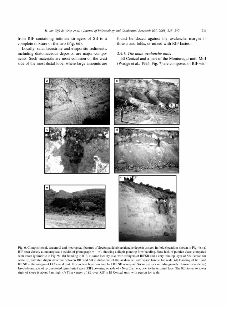
from RIF containing intimate stringers of SB to a
complete mixture of the two (Fig. 6d).
Locally, salar lacustrine and evaporitic sediments,
including diatomaceous deposits, are major compo-
nents. Such materials are most common on the west
side of the most distal lobe, where large amounts are
found bulldozed against the avalanche margin in
thrusts and folds, or mixed with RIF facies.
2.4.1. The main avalanche units
El Cenizal and a part of the Monturaqui unit, Mo1
(Wadge et al., 1995, Fig. 7) are composed of RIF with
B. van Wyk de Vries et al. / Journal of Volcanology and Geothermal Research 105 (2001) 225±247 231
e
f
d
b
c
a
Fig. 6. Compositional, structural and rheological features of Socompa debris avalanche deposit as seen in ®eld (locations shown in Fig. 4). (a)
RIF seen closely at outcrop scale (width of photograph� 1 m), showing a diapir piercing ¯ow banding. Note lack of pumice clasts compared
with intact ignimbrite in Fig. 9a. (b) Banding in RIF, at same locality as e, with stringers of RIFSB and a very thin top layer of SB. Person for
scale. (c) Inverted diapir structure between RIF and SB in distal end of the avalanche, with spade handle for scale. (d) Banding of RIF and
RIFSB at the margin of El Cenizal unit. It is unclear here how much of RIFSB is original Socompa rock or Salin gravels. Person for scale. (e)
Eroded remnants of reconstituted ignimbrite facies (RIF) covering on side of a Negrillar lava, next to the terminal lobe. The RIF tower to lower
right of slope is about 4 m high. (f) Thin veneer of SB over RIF in El Cenizal unit, with person for scale.
a thin overlying layer (0.5±2 m) of light coloured SB.
The other Monturaqui units also have an upper
layer of SB, the thickness of which is greater (2
to .15 m), and some RIFSB is found below. The
whole deposit is, therefore, based on a thick RIF
cushion, with a veneer of Socompa-derived rock
(SB), and some minor amounts of mixing between the
two.
Volume estimates can only be approximate, as the
thickness of the deposit is poorly constrained (Wadge
et al., 1995), and there is considerable variation in the
thickness of separate units. Our estimates here are a
re®nement of previous ones, due to the increased
vertical data provided by new roadcuts, but they are
not ®nal.
We estimate, using all available outcrops, the
average SB thickness in the El Cenizal unit to be
2 m. Estimating the Monturaqui unit thickness is
more dif®cult, as the base does not generally out
crop in road cuttings. However, 15 m is probably a
reasonable upper estimate, based on the total thick-
ness of the avalanche deposit (Wadge et al., 1995).
We arrive at a total SB volume of about 5.5 km3,
with no allowance for volume increase from intact
to fragmented rock. Even so, this estimate is smaller
than our independent estimate of the scar wedge
volume of about 6 km3; the remaining volume prob-
ably resides in the toreva blocks. With a SB estimate
of 5.5 km3, the volumetric proportion of Salin
substrata is therefore likely to be about 20 km3
(80% of the total avalanche 25 km3, excluding the
toreva block 11 km3).
Our uncertainties remain on the order of 30% for
the SB volume, due to the dif®culty in determining
thickness. The main source of overestimation of the
SB in the El Cenizal unit is the large quantity of
Socompa-like clasts in the Salin gravel and boulder
beds. A large proportion of the surface layer on the El
Cenizal unit may be made of this material. Some of
the RIFSB may be Salin gravel layers mixed with RIF.
The major source of underestimation of RIF content
comes from the removal of ®ne, loose RIF from the
deposit surface. In cuttings, RIF disturbed by roadcuts
forms banks of very mobile and porous dust, easily
disturbed. Such a mantle may have covered much of
the avalanche, probably now removed by wind. On El
Cenizal unit margins remnants of this cover are still
preserved (Fig. 6e).
B. van Wyk de Vries et al. / Journal of Volcanology and Geothermal Research 105 (2001) 225±247232
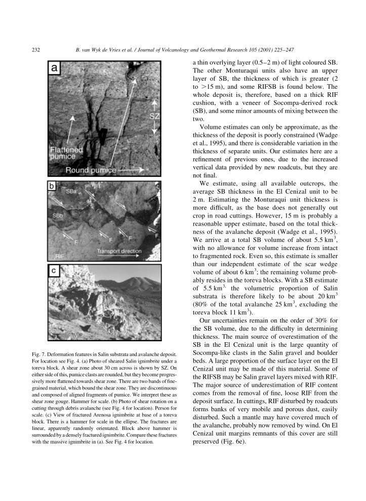
Fig. 7. Deformation features in Salin substrata and avalanche deposit.
For location see Fig. 4. (a) Photo of sheared Salin ignimbrite under a
toreva block. A shear zone about 30 cm across is shown by SZ. On
either side of this, pumice clasts are rounded, but they become progres-
sively more ¯attened towards shear zone. There are two bands of ®ne-
grained material, which bound the shear zone. They are discontinuous
and composed of aligned fragments of pumice. We interpret these as
shear zone gouge. Hammer for scale. (b) Photo of shear rotation on a
cutting through debris avalanche (see Fig. 4 for location). Person for
scale. (c) View of fractured Arenosa ignimbrite at base of a toreva
block. There is a hammer for scale in the ellipse. The fractures are
linear, apparently randomly orientated. Block above hammer is
surrounded by a densely fractured ignimbrite. Compare these fractures
with the massive ignimbrite in (a). See Fig. 4 for location.
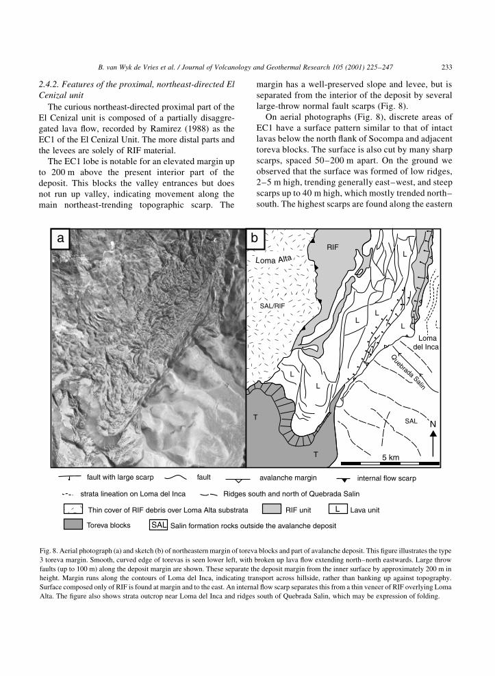
2.4.2. Features of the proximal, northeast-directed El
Cenizal unit
The curious northeast-directed proximal part of the
El Cenizal unit is composed of a partially disaggre-
gated lava ¯ow, recorded by Ramirez (1988) as the
EC1 of the El Cenizal Unit. The more distal parts and
the levees are solely of RIF material.
The EC1 lobe is notable for an elevated margin up
to 200 m above the present interior part of the
deposit. This blocks the valley entrances but does
not run up valley, indicating movement along the
main northeast-trending topographic scarp. The
margin has a well-preserved slope and levee, but is
separated from the interior of the deposit by several
large-throw normal fault scarps (Fig. 8).
On aerial photographs (Fig. 8), discrete areas of
EC1 have a surface pattern similar to that of intact
lavas below the north ¯ank of Socompa and adjacent
toreva blocks. The surface is also cut by many sharp
scarps, spaced 50±200 m apart. On the ground we
observed that the surface was formed of low ridges,
2±5 m high, trending generally east±west, and steep
scarps up to 40 m high, which mostly trended north±
south. The highest scarps are found along the eastern
B. van Wyk de Vries et al. / Journal of Volcanology and Geothermal Research 105 (2001) 225±247 233
fault with large scarp avalanche margin internal flow scarpfault
strata lineation on Loma del Inca Ridges south and north of Quebrada Salin
Thin cover of RIF debris over Loma Alta substrata RIF unit Lava unit
Toreva blocks
L
Salin formation rocks outside the avalanche depositSAL
SAL
Quebrada Salin
5 km
RIF
L
L
L
L
L
L
NT
T
SAL/RIF
Loma Alta
Lomadel Inca
a b
Fig. 8. Aerial photograph (a) and sketch (b) of northeastern margin of toreva blocks and part of avalanche deposit. This ®gure illustrates the type
3 toreva margin. Smooth, curved edge of torevas is seen lower left, with broken up lava ¯ow extending north±north eastwards. Large throw
faults (up to 100 m) along the deposit margin are shown. These separate the deposit margin from the inner surface by approximately 200 m in
height. Margin runs along the contours of Loma del Inca, indicating transport across hillside, rather than banking up against topography.
Surface composed only of RIF is found at margin and to the east. An internal ¯ow scarp separates this from a thin veneer of RIF overlying Loma
Alta. The ®gure also shows strata outcrop near Loma del Inca and ridges south of Quebrada Salin, which may be expression of folding.
margin 2±4 km from the toreva blocks. On the
¯anks of the scarps we observed some outcrops of
RIF and evaporite blocks. This morphology
continues about 10 km northwards from the toreva
blocks to where there is a tongue of lava-covered
material extending westwards. On aerial photo-
graphs this tongue has a chaotic surface texture,
distinct from the rest of the unit. We interpret the
low east±west ridges as relict lava ¯ow morphology,
the north±south scarps as faults cutting the lava
¯ow, and the tongue texture as a fully disaggregated
¯ow. This interpretation implies that the lava ¯ow
was rafted on the avalanche and that portions
remained intact even after 200 m of de¯ation.
2.4.3. Evidence relating to fragmentation of material
Outcrops of RIF very rarely contain intact blocks of
Salin rock, and these are limited to proximal areas
such as the Lion's Paw (Fig. 5), or distal areas
where the avalanche bull-dozed salar sediments
(Wadge et al., 1995). It is surprising that the ignim-
brite strata are so rarely seen intact, as many other
debris avalanches preserve considerable quantities of
relict bedding (Siebert, 1984). Elsewhere RIF resem-
bles Salin ignimbrite, but there are distinct differences:
(a) the RIF contains gravel- to boulder-size clasts of
andesite and dacite, similar to that found in the Salin
gravels and Socompa clasts;
(b) RIF lacks pumice clasts which are common in
Salin ignimbrite layers (compare Fig. 6a with Fig. 7a);
(c) layering in the RIF, where found, is discon-
tinuous and the boundaries between layers are indis-
tinct, wavy and wispy appearing ¯uid-like (Fig. 6b).
Commonly one layer pierces another with diapiric
structures (Fig. 6a and c);
(d) previous stratigraphy has been obliterated,
though a new foliation or banding can be sometimes
found (Figs. 6 and b);
(e) the RIF is dominantly (about 80%) composed of
ash size particles.
The material at the contact between SB and RIF
often has evidence of brittle behaviour, with faults
and rotation of blocks usually indicating shear
between RIF and SB (Fig. 7b). Between the volcano
and the secondary scarp the faults are consistently
normal, and all observed occurrences dip away from
the volcano. If viewed from the southeast, the rotation
sense of intervening blocks is anticlockwise (Fig. 7b).
To produce this sense of shear the underlying RIF
must have been moving at a greater rate than the SB
above. The lower RIF facies travelled the furthest and
it forms all the distal lobes (Fig. 5), which also indi-
cates that it was more mobile than the overlying SB
material.
On very close inspection, the contact between SB
and RIF contacts display wispy mixing features, indi-
cating local ¯uid-like behaviour (Fig. 6a, c and d). The
banding shown in Fig. 7b separates one size range of
fragmental material from another. It is different from
any banding seen in in situ Salin ignimbrite, but
instead appears to be a product of ¯uid-like granular
¯ow. Brittle structures are most prevalent in the
Monturaqui unit, and the notable ridges in the
avalanche surface in this unit (Francis et al., 1985)
are probably surface expressions of faults such as
those shown in Fig. 7b.
These observations lead us to propose that the RIF
was formed by complete fragmentation of Salin
ignimbrites and gravels, but with only very limited
intermixing of Socompa edi®ce material.
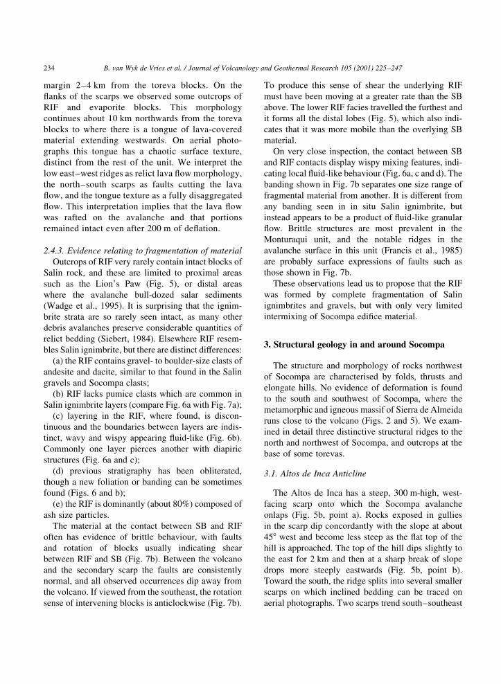
3. Structural geology in and around Socompa
The structure and morphology of rocks northwest
of Socompa are characterised by folds, thrusts and
elongate hills. No evidence of deformation is found
to the south and southwest of Socompa, where the
metamorphic and igneous massif of Sierra de Almeida
runs close to the volcano (Figs. 2 and 5). We exam-
ined in detail three distinctive structural ridges to the
north and northwest of Socompa, and outcrops at the
base of some torevas.
3.1. Altos de Inca Anticline
The Altos de Inca has a steep, 300 m-high, west-
facing scarp onto which the Socompa avalanche
onlaps (Fig. 5b, point a). Rocks exposed in gullies
in the scarp dip concordantly with the slope at about
458 west and become less steep as the ¯at top of the
hill is approached. The top of the hill dips slightly to
the east for 2 km and then at a sharp break of slope
drops more steeply eastwards (Fig. 5b, point b).
Toward the south, the ridge splits into several smaller
scarps on which inclined bedding can be traced on
aerial photographs. Two scarps trend south±southeast
B. van Wyk de Vries et al. / Journal of Volcanology and Geothermal Research 105 (2001) 225±247234
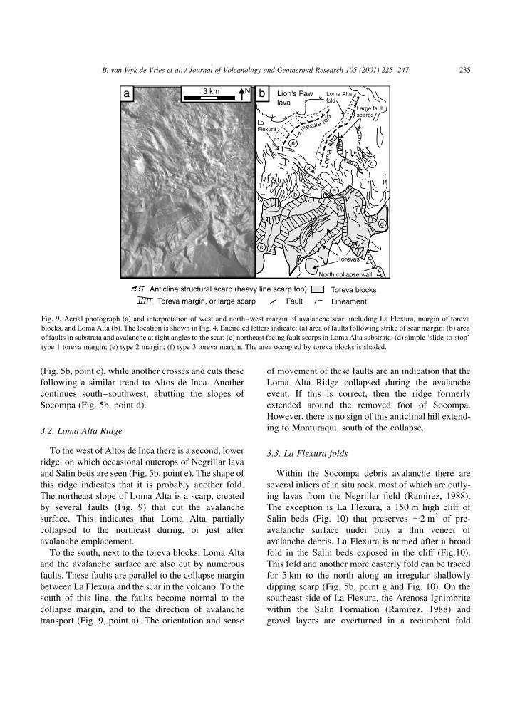
(Fig. 5b, point c), while another crosses and cuts these
following a similar trend to Altos de Inca. Another
continues south±southwest, abutting the slopes of
Socompa (Fig. 5b, point d).
3.2. Loma Alta Ridge
To the west of Altos de Inca there is a second, lower
ridge, on which occasional outcrops of Negrillar lava
and Salin beds are seen (Fig. 5b, point e). The shape of
this ridge indicates that it is probably another fold.
The northeast slope of Loma Alta is a scarp, created
by several faults (Fig. 9) that cut the avalanche
surface. This indicates that Loma Alta partially
collapsed to the northeast during, or just after
avalanche emplacement.
To the south, next to the toreva blocks, Loma Alta
and the avalanche surface are also cut by numerous
faults. These faults are parallel to the collapse margin
between La Flexura and the scar in the volcano. To the
south of this line, the faults become normal to the
collapse margin, and to the direction of avalanche
transport (Fig. 9, point a). The orientation and sense
of movement of these faults are an indication that the
Loma Alta Ridge collapsed during the avalanche
event. If this is correct, then the ridge formerly
extended around the removed foot of Socompa.
However, there is no sign of this anticlinal hill extend-
ing to Monturaqui, south of the collapse.
3.3. La Flexura folds
Within the Socompa debris avalanche there are
several inliers of in situ rock, most of which are outly-
ing lavas from the Negrillar ®eld (Ramirez, 1988).
The exception is La Flexura, a 150 m high cliff of
Salin beds (Fig. 10) that preserves ,2 m2 of pre-
avalanche surface under only a thin veneer of
avalanche debris. La Flexura is named after a broad
fold in the Salin beds exposed in the cliff (Fig.10).
This fold and another more easterly fold can be traced
for 5 km to the north along an irregular shallowly
dipping scarp (Fig. 5b, point g and Fig. 10). On the
southeast side of La Flexura, the Arenosa Ignimbrite
within the Salin Formation (Ramirez, 1988) and
gravel layers are overturned in a recumbent fold
B. van Wyk de Vries et al. / Journal of Volcanology and Geothermal Research 105 (2001) 225±247 235
Toreva margin, or large scarp
Anticline structural scarp (heavy line scarp top) Toreva blocks
Fault Lineament
Lion's Pawlava
LaFlexura
Loma Altafold
Large faultscarps
North collapse wall
Torevas
a
a
a
c
f
e
d
b
La Flexura f old
Lom
aA
lta
3 km Na b
Fig. 9. Aerial photograph (a) and interpretation of west and north±west margin of avalanche scar, including La Flexura, margin of toreva
blocks, and Loma Alta (b). The location is shown in Fig. 4. Encircled letters indicate: (a) area of faults following strike of scar margin; (b) area
of faults in substrata and avalanche at right angles to the scar; (c) northeast facing fault scarps in Loma Alta substrata; (d) simple `slide-to-stop'
type 1 toreva margin; (e) type 2 margin; (f) type 3 toreva margin. The area occupied by toreva blocks is shaded.
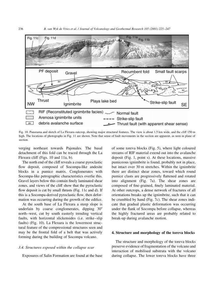
verging northeast towards Pajonales. The basal
detachment of this fold can be traced through the La
Flexura cliff (Figs. 10 and 11a, b).
The north end of the cliff reveals a coarse pyroclastic
¯ow deposit, composed of Socompa-like andesite
blocks in a pumice matrix. Conglomerates with
Socompa-like petrographic characteristics overlie this.
Gravel layers below this contain ®nely laminated shear
zones, and views of the cliff show that the pyroclastic
¯ow deposit is cut by small thrusts (Fig. 11c and d). If
this is a Socompa-derived pyroclastic ¯ow, then defor-
mation was occurring during the growth of the edi®ce.
At the south base of La Flexura a steep slope is
underlain by coarse conglomerates, dipping 308north±west, cut by south easterly trending vertical
faults, with horizontal slickensides (i.e. strike±slip
faults) (Fig. 10). La Flexura is the lowermost struc-
tural feature of the compressional structures seen and
may be the frontal fold of a belt that was actively
forming during the building of Socompa volcano.
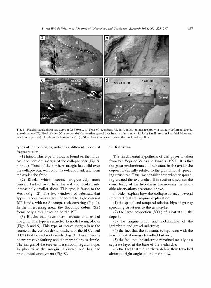
3.4. Structures exposed within the collapse scar
Exposures of Salin Formation are found at the base
of some toreva blocks (Fig. 5), where light coloured
streams of RIF material extend out into the avalanche
deposit (Fig. 1, point s). At these locations, massive
pumiceous ignimbrite is found, probably not in place,
but intact over 30 m stretches. Within the ignimbrite
there are distinct shear zones, toward which round
pumice clasts are progressively ¯attened and rotated
into alignment (Fig. 7a). The shear zones are
composed of ®ne-grained, ®nely laminated material.
At other outcrops, a dense network of fractures of all
orientations breaks up the ignimbrite, such that it can
be crumbled by hand (Fig. 7c). The shear zones indi-
cate that gradual plastic deformation was occurring
under the ¯ank of Socompa before collapse, whereas
the highly fractured areas are probably related to
break-up during avalanche motion.
4. Structure and morphology of the toreva blocks
The structure and morphology of the toreva blocks
preserve evidence of fragmentation of the volcano and
interaction of mobilised substrata with the volcano
during collapse. The lower toreva blocks have three
B. van Wyk de Vries et al. / Journal of Volcanology and Geothermal Research 105 (2001) 225±247236
Fig. 10. Panorama and sketch of La Flexura outcrop, showing major structural features. The view is about 1.5 km wide, and the cliff 150 m
high. The locations of photographs in Fig. 11 are shown. Note that sense of fault movements in the section are apparent, as seen in plane of
section.
types of morphologies, indicating different modes of
fragmentation:
(1) Intact. This type of block is found on the north-
east and northern margin of the collapse scar (Fig. 9,
point d). Those of the northern margin have slid over
the collapse scar wall onto the volcano ¯ank and form
the avalanche front.
(2) Blocks which become progressively more
densely faulted away from the volcano, broken into
increasingly smaller slices. This type is found to the
West (Fig. 12). The few windows of substrata that
appear under torevas are connected to light colored
RIF bands, with no Socompa rock covering (Fig. 1).
In the intervening areas the Socompa debris (SB)
forms only a thin covering on the RIF.
(3) Blocks that have sharp, arcuate and eroded
margins. This type is restricted to north facing blocks
(Figs. 8 and 9). This type of toreva margin is at the
source of the curious deviant salient of the El Cenizal
(EC1) that ¯owed northwards (Fig. 3). Here, there is
no progressive faulting and the morphology is simple.
The margin of the torevas is a smooth, regular slope.
In plan view the margin is curved and has one
pronounced embayment (Fig. 8).
5. Discussion
The fundamental hypothesis of this paper is taken
from van Wyk de Vries and Francis (1997). It is that
the great predominance of substrata in the avalanche
deposit is causally related to the gravitational spread-
ing structures. Thus, we consider here whether spread-
ing created the avalanche. This section discusses the
consistency of the hypothesis considering the avail-
able observations presented above.
In order explain how the collapse formed, several
important features require explanation:
(1) the spatial and temporal relationships of gravity
spreading structures to the avalanche;
(2) the large proportion (80%) of substrata in the
deposit;
(3) the fragmentation and mobilisation of the
ignimbrite and gravel substrata;
(4) the fact that the substrata components with the
least potential energy travelled farthest;
(5) the fact that the substrata remained mainly as a
separate layer at the base of the avalanche;
(6) the fact that the northern debris ¯ow travelled
almost at right angles to the main ¯ow.
B. van Wyk de Vries et al. / Journal of Volcanology and Geothermal Research 105 (2001) 225±247 237
H
H
Shear band
Shear bandFracturec d
a b
Shearedgravels
Shearedgravels
PF
PF
PF
Gravel
Ig
Ig
Ig
G
Fig. 11. Field photographs of structures at La Flexura. (a) Nose of recumbent fold in Arenosa ignimbrite (Ig), with strongly deformed layered
gravels in core (G). Field of view 50 m across. (b) Near vertical gravel beds in nose of recumbent fold. (c) Small thrust in 3 m-thick block and
ash ¯ow layer (PF). H indicates a horizon in PF. (d) Shear bands in gravels below the block and ash ¯ow.
5.1. Possible mechanisms for sector collapse at
Socompa volcano
Gravitational spreading is a consequence of the
growth of a volcano on a weak substratum; the load-
ing results in deformation of the underlying rocks.
The nature of the deformation depends on the material
properties of both volcano and substrata. If the volca-
no's core is weak it may be involved in the deforma-
tion and spread laterally (Merle and Borgia, 1996; van
Wyk de Vries et al., 2000). The substrata (and lower
part of the volcano) will initially respond to loading
with an elastic response and by compaction. Subse-
quently, the substrata may deform gradually in a more
plastic or ductile manner (Van Bemmelen, 1970;
Nakamura, 1980; Merle and Borgia, 1996). If there
is a thin ductile layer, or decolleÂment(s) below the
volcano, then the substrata spread laterally away
from the cone (Merle and Borgia, 1996; van Wyk de
Vries and Borgia, 1996). This can lead to two styles of
deformation dependent on whether the volcanic edi®ce
spreads with the substrata (`volcano spreading'), or
B. van Wyk de Vries et al. / Journal of Volcanology and Geothermal Research 105 (2001) 225±247238
N2 km
N2 km
a
b
Fig. 12. Aerial photograph (a) and sketch of faulting (b) at collapsed margins of central toreva blocks. This ®gure illustrates the type 2 toreva
margin. Downthrow on large block margins and faults are indicated by bar and ball. For smaller faults, the throw and dip are generally down to
the east or northeast (upper left or top). Shaded areas pick out substrata and RIF outcrop, and speckled areas represent post-collapse material.
whether the volcano and substrata are decoupled, in
which case the substrata are extruded from under the
cone: (`substrata extrusion') (van Wyk de Vries and
Matela, 1998). In either case, a compressional fold
and thrust belt is produced at the foot of the volcano,
due to the outwards-directed lateral transport. During
volcano spreading, the edi®ce gets ¯atter and wider
and is cut by extensional faults. In contrast, with
extrusion, the volcano remains steep and is subject
to shear stresses that can produce compressional faults
within the edi®ce (van Wyk de Vries and Matela,
1998).
The role of a mechanically weak substratum in
promoting sector collapse was recognised at Momba-
cho volcano, Nicaragua, where the collapse scar cut
deeply into the underlying ignimbrite, allowing large
amounts of substrata to be incorporated into the
avalanche deposit (van Wyk de Vries and Francis,
1997). Weak substrata enhance the likelihood of
collapse, because they extrude at a high rate and
produce large slope-parallel shear stresses in the
edi®ce (van Wyk de Vries and Matela, 1998).
5.2. Structural synthesis
Within the La Flexura±Loma del Inca area there is
a fold and thrust belt with three main folds: Loma del
Inca, Loma Alta, and La Flexura. There is no morpho-
logical evidence of deformation further west of La
Flexura and so it probably is the deformation front.
The fold belt's orientation and its restriction to the
volcano base suggest that it is directly related to the
presence of Socompa and Pajonales volcanoes. The
westernmost two structures, La Flexura and Loma
Alta, are both cut by the Socompa avalanche scar,
and originally probably extended some way around
the base of the volcano (Figs. 5 and 13). The shear
structures found in intact ignimbrite under toreva
blocks indicate that deformation extended this far.
There is, however, no structural or morphological
evidence that the structures continue on the southeast
side of Socompa.
Thrust vergeance, shearing directions and trends
are variable. The Loma del Inca trends north, tangen-
tial to Pajonales Volcano. Loma Alta and La Flexura
swing around to the northeast, approaching tangential
to Socompa and parallel to the sector collapse mouth
(Fig. 3). Some structures at La Flexura, such as the
recumbent fold, are tangential to Pajonales, which
may indicate that La Flexura and Loma Alta belong
to a second phase of deformation altering original
spreading structures from the older Pajonales. The
area between Socompa and Loma del Inca contains
a series of ridges, both radial and tangential to
Socompa, which may represent a zone of structural
interference between the two volcanoes.
An alternative explanation for recumbent folding at
La Flexura is that it is the product of transpression along
a strike±slip fault separating two spreading sectors.
Strike±slip faults are a common accompaniment to
B. van Wyk de Vries et al. / Journal of Volcanology and Geothermal Research 105 (2001) 225±247 239
68˚ 20' 68˚ 15'
24˚25'
24˚15'
4000
3200
24˚20
LF
LI
LI
4000
ridge
Socompa
LA
5 km
Paj
onal
es
Monturaqui basin
?
N
a
a'
possible scarcontinuation
basin
Lion's PawLava
Fig. 13. Reconstruction of Socompa topography and structure
before sector collapse. The volcano stood high above the south
east edge of the Monturaqui basin. La Flexura (LF) and Loma
Alta (LA) anticlines extended round the north west base of volcano.
Reconstructed Loma Alta Ridge is stippled for emphasis around the
3600 m contour. Lava ¯ows emplaced a short time before collapse
are shaded. The exact distribution of these within the scar is spec-
ulative. Those lavas that ¯owed to the north are diverted by the
Loma Alta Ridge. The position of these lavas is well constrained,
as they were not transported far in the collapse. They are now seen
as the northeastern toreva blocks and the lava rafted on the EC1
(Fig. 8). Loma del Inca anticlinal hill is also shown below Pajonales
volcano, and possible anticlinal hills between the two volcanoes are
also shown. Border of collapse scar is shown as a dashed line.
Dotted line a Ð a 0 indicates line of section in Fig. 14.
spreading-related thrusting (van Bemmelen, 1970;
van Wyk de Vries and Borgia, 1996), and vertical
faults below La Flexura have horizontal slickensides
(Fig. 10). Any deviation from a radial orientation on
such faults or interference from more than one stress
source (Socompa and Pajonales Volcanoes) is likely
to cause transpression along strike±slip sector bound-
aries. This will result in thrusting and folding along
the fault zone.
We have reconstructed the pre-collapse structure
and topography of Socompa using such evidence as
the truncated Loma Alta and La Flexura anticlines and
the shearing found in Salin beds below torevas
(Figs. 13 and 14). From the reconstruction we can
B. van Wyk de Vries et al. / Journal of Volcanology and Geothermal Research 105 (2001) 225±247240
b
a
LALF
km
σ1
σ1σ1
BasinExtruding substrata
Slope parallelcompression
Saggingedifice
bc
d
a
NW
NW
SE
SE
c
NW
SE
fsfv
Ponded lavas
Anticlines
High ratesof shear
Outward flow
6000 m
5000 m
3000 m
km
6000 m
5000 m
3000 m
km
6000 m
5000 m
3000 m
a a'
a a'
a a'
??
possible faults accomodatingvolume loss from below
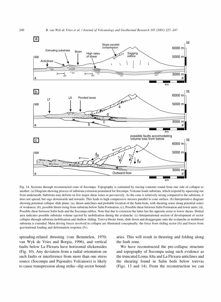
Fig. 14. Sections through reconstructed cone of Socompa. Topography is estimated by tracing contours round from one side of collapse to
another. (a) Diagram showing process of substrata extrusion postulated for Socompa. Volcano loads substrata, which respond by squeezing out
from underneath. Substrata may deform on few major shear zones or pervasively. As the cone is relatively strong compared to the substrata, it
does not spread, but sags downwards and inwards. This leads to high compressive stresses parallel to cone surface. (b) Interpretative diagram
showing potential collapse slide plane: (a), thrust-anticlines and probable location of the Salin beds, with shearing sense along potential zones
of weakness; (b), possible thrust rising from substrata below Salin Formation; (c), Possible shear between Salin Formation and lower units; (d),
Possible shear between Salin beds and the Socompa edi®ce. Note that due to extrusion the latter has the opposite sense to lower shears. Dotted
area indicates possible substrata volume ejected by mobilisation during the avalanche. (c) Interpretational section of development of sector
collapse through substrata mobilisation and shallow sliding. Toreva blocks form, slide down and disaggregate onto the avalanche as mobilised
substrata is extruded. Main driving forces involved in collapse are illustrated conceptually: the force from sliding sector (fs) and forces from
gravitational loading and deformation response (fv).
estimate the volume of lost substrata material. The
detachment plane may have followed the frontal La
Flexura thrust, which probably steps down toward the
volcano (Fig. 14b, decollement b). Alternatively, it
may have followed a more horizontal or climbing
slope (Fig. 14b, decollement c). This latter scenario
may be more likely as no deeper strata, from below
the Salin Formation, are included in the avalanche.
With a horizontal plane, we calculate a rough initial
volume of the substratum component by a 8 km-long
slice, 10 km wide and with a thickness of 300±400 m.
This gives 24±32 km3, roughly similar to that esti-
mated above for the basement component in the
avalanche. Calculation can only be approximate, as
there is little constraint on the original surface topo-
graphy, or the exact depth of the failure. The role of
bulking of the basement component is also dif®cult to
assess; however, as the original Salin deposit is
roughly as porous as the RIF we have neglected this
complication.
5.3. Interpreting the toreva structure
The ®rst (simplest) toreva block margin type has
undergone minimal disruption and was probably
formed by blocks simply sliding a short distance
downslope. For the second margin type (Fig. 12),
the increase in fault density may be explained by
material moving progressively faster further away
from the block, and a decrease in thickness of a brittle
top layer carried on a ductile, or ¯uidised layer of
Salin Formation. The latter would require a catastro-
phically extruding mobilised layer below the toreva
blocks. This hypothesis would also have the toreva
blocks contributing material to the upper layer of
the avalanche, forming the SB material. It also implies
that the blocks slid as the avalanche was developing,
rather than slipping down afterwards. In this model,
they are integral to the development of the avalanche.
The third margin type (Figs. 8 and 9) is at the origin
of the north-¯owing salient. We consider four pieces
of evidence to be signi®cant for its interpretation:
(a) the degree of surface fragmentation is much
lower than elsewhere, indeed the avalanche may
even have preserved some relict surface features of
the lava ¯ows;
(b) the surface texture of unaffected lava ¯ows on
the north ¯ank, the toreva blocks and the lava unit of
the avalanche are similar. Although, in the latter case
they are cut by many large faults (Fig. 8). This indi-
cates that the lava ¯ow remained partially intact as it
rafted on top of the RIF;
(c) the orientation and the large throws of the faults
(Fig. 8) point to major proximal de¯ation of the
deposit;
(d) the elevated east margin has indications of slope
parallel momentum-dominated transport and lateral
¯ow across valley mouths (Fig. 8). This implies that
the initial avalanche surface was level with this
margin.
We consider that the points (a) and (b) indicate that
the EC1 lava has not been transported far from its
original position, and that it originally occupied the
valley between Loma Alta and Altos de Inca. Points
(c) and (d) indicate that, during its initial emplace-
ment, the avalanche surface was 100±200 m higher
than at present.
To account for the large drop in level of the
avalanche we suggest that a large volume of substra-
tum material passed out from underneath the lava-
dominated surface. This travelled on to form the
main part of the EC1 deposit. As this was going on,
the northeastern toreva blocks were faulted and the
lower lava ¯ow unit was rafted on the extruding
substrata. The load of the emplaced avalanche may
then have contributed to the coeval partial collapse of
the Loma Alta.
We envision that the mobilised substrata was
ejected from underneath toreva blocks as they were
sliding down. The lower parts of the blocks would
have been carried out on top of the extruding substrata
to form the upper Socompa-dominated unit of the
avalanche (SB).
5.4. Style of spreading: substrata extrusion at
Socompa
For a volcano to spread on its substrata, the
substrata must contain a layer weak enough to deform
at a geologically signi®cant rate under the load of the
edi®ce (Nakamura, 1980; van Wyk de Vries and
Matela, 1998). A signi®cant rate is one that produces
structures before other processes, such as erosion or
caldera formation, remove the loading. The Salin
Formation is composed of weak rocks and they exhi-
bit an abundance of deformation structures. Erosion is
B. van Wyk de Vries et al. / Journal of Volcanology and Geothermal Research 105 (2001) 225±247 241
very slow in the region and Socompa has not been
disrupted by caldera collapse. Thus, the Socompa
situation is ideal for undergoing spreading.
There is no evidence of spreading-related extension
on the cone of Socompa, and evidence of only minor
faulting on Pajonales, yet both have basal spreading
structures. Such a situation could be produced by
continual resurfacing of the volcanic edi®ce, such as
at ConcepcioÂn, Nicaragua (van Wyk de Vries and
Borgia, 1996). However, because there has been no
activity at Pajonales for many thousands of years, this
cannot apply here.
Regional compression might produce thrusting
without extension in volcanoes, but as there is no
evidence of large regional structures, and as the defor-
mation is restricted to the ductile cover rocks, we
consider this an unlikely explanation.
Another way of producing basal thrusts with little
apparent volcano deformation is if the substrata
extrude from below the edi®ce (van Wyk de Vries
and Matela, 1998). In such a case, the volcano is
coherent and strong in relation to substrata, and so it
does not break up. Instead, the edi®ce sags down-
wards as substrata squeezes out from underneath.
The upper part of the volcano is compressed, with
slope-parallel maximum compressive stress (Fig. 14a).
Large, coherent dacitic lava ¯ows cover much of
the surface of Pajonales and Socompa, and the
Socompa collapse scar exposures are lava dominated.
Such a construction is likely to be strong and coherent,
creating optimum conditions for substrata extrusion.
We have presented evidence above of substrata
deforming prevasively, by folding and by thrusting.
Because of this we interpret the structures at Socompa
and Pajonales as being a result of substrata extrusion
(Fig. 14b).
5.5. Styles of thrust anticline development
There are considerable differences in the structural
style and amplitude of spreading features around
Socompa and Pajonales. In this section we discuss
why there is a variation and consider the relationship
of different styles to sector collapse. We divide the
area up into four distinctive sub-areas (Figs. 3 and 5).
1. Monturaqui: no deformation visible; here the
Salin beds of Arenosa ignimbrite dip gently north-
wards.
2. La Flexura±Pajonales: well-developed structural
uplift and thrusting, with the Socompa sector collapse
(Fig. 5).
3. Negrillar: slight uplift and folding, normal faults
over fold hinges, little deformation after the Negrillar
lava ®eld emplacement.
4. Northwest Pajonales: structural uplift and thrust-
ing. In this area there are a number of well-developed
thrusts and anticlinal ridges (van Wyk de Vries et al.,
1996).
In the case of Monturaqui, the volcano abuts the
granite basement massif of the Sierra Almeida.
Here, the lack of deformation can be correlated with
the absence of a deformable layer.
For areas 2 and 4, the structures are well developed
and the deformable layer is the Salin Formation. In
these areas, an elongate basin is formed behind each
anticline, in which sediments and lavas have
collected. The basins may contain several km3 of
material, the load of which will increase deformation
and make anticline failure more likely.
For area 3, the Negrillar lava ®eld, there is a
much more subdued style of deformation. There is
uplift and Salin strata are steepened into a broad
fold, while normal faults have developed over the
hinge. We have not located any faults cutting the
fresh lava ¯ow surfaces, so no large-scale deforma-
tion has happened after their eruption. To explain
the lack of deformation we suggest a counter-
balancing operation, by which the lavas have
increased the mass enough to offset the load from
Pajonales, thus restricting deformation and stabili-
sing the volcano.
In conclusion, where there are deformable
substrata, spreading structures are observed. Their
amplitude and style are dependant on the local condi-
tions: if the rising anticlines are loaded on top, or
buttressed by other material (such as the Negrillar
lavas), then spreading is inhibited. Where anticlines
form they can collect lava and sediment behind them.
Ponded material adds an extra load behind the anticli-
nes, which will increase rates of movement and
contribute to the collapse process. We do not know
the actual extent of the loading effect, but point out
that a similar effect has been shown to be important in
foreland thrust regions (Merle and Abidi, 1995). This
topic requires more study, probably by an analogue
and numerical approach.
B. van Wyk de Vries et al. / Journal of Volcanology and Geothermal Research 105 (2001) 225±247242
5.6. Evidence for the behaviour of substrata rocks
during spreading
In this section, we consider the evidence for the
material behaviour of the Salin Formation during
spreading. We also propose a possible process for
the mobilisation of ignimbrites under the high shear
stresses and high strain rates expected during
spreading.
The Salin Formation can be divided into two basic
rock types: pyroclastic ¯ow deposits (ignimbrites and
lithic-rich pyroclastic ¯ows), and coarse sediments
(gravels and conglomerates). The small lenses of
evaporites present in the Salin probably effect only
localised deformation. The ignimbrites form a conso-
lidated mixture of highly porous pumice and ash with
a few lithics. The pumice clasts in the ignimbrites are
less strong than the cement and are easily crushed.
The rock cannot be fractured without breaking the
clasts themselves. Thus, the strength of the rock is
limited by the fragile pumice clasts. By contrast, the
sediments are poorly consolidated and are composed
of compact lithic clasts, with no pumice. In these
beds, the clasts are stronger than the bonds between
them. Both rock types are very porous.
Small-scale deformation features re¯ect the
properties of the two rock types. The ignimbrite mate-
rial has responded by clast deformation over broad
zones (e.g. the reoriented clasts in Fig. 7a) and by
clast fragmentation in discrete zones (e.g. the ®ne
bands in the shear zone in Fig. 7a). Another style
found at these outcrops is severe fracturing of the
rock (Fig. 7c). This mode cuts shear zones and is a
later feature. Such fracturing may be an intermediate
stage between the intact sheared rock and the comple-
tely disaggregated avalanche material. The sediments
have formed many small, closely spaced shear bands
(Fig. 11d). The total displacement accumulated over
these shears is considerable, judging from stretching,
thinning and folding of enclosed pyroclastic strata
(Fig. 11a and c).
Behaviour of strata is likely to be different
beneath the cone (where volcano load is high) to
that in developing anticlines (which are respond-
ing to push from behind). In addition, it is likely
that different rates of shear developed and hence
rock response differed as conditions for collapse
developed.
We can deduce general material response beneath
the cone from the type of spreading observed. The
extrusion style of spreading inferred in the previous
section requires weak, ductile substrata, capable of
being squeezed out from under the cone. Direct
evidence of ductile behaviour 100±300 m below the
volcano ¯ank comes from outcrops below toreva
blocks (Fig. 7).
The La Flexura locality provides evidence of defor-
mation behaviour in the spreading anticlines. Ductile
behaviour is indicated by the large recumbent fold and
shearing of gravels and ignimbrite (Figs. 10 and 11).
This deformation must have occurred at less than
200 m depth.
From the above we deduce that the Salin Formation
was able to behave in a ductile manner under shear at
low con®ning pressures. Our ®eld observations
suggest that this deformation occurred in ignimbrites
by break-up and deformation of weak pumice clasts,
and in gravels by shearing between grains along many
small planes.
Although the actual stress±strain behaviour of a
Salin Formation ignimbrite is not known, as material
tests have not been done, there are data for rocks that
should behave similarly, such as chalk (Petley et al.,
1992; Leddra et al., 1993). Chalk and ignimbrite are
both composed of porous clasts, in the former case
skeletal, in the latter pumiceous. Both rock types are
poorly to moderately cemented, at least when consid-
ering Salin Formation ignimbrites. In both cases,
clasts may be weaker than bonds between them, and
clasts are likely to break and deform under stress
(Petley et al., 1992).
Chalk has been observed to ¯ow under the high
strain rates of rock falls and under high deviatoric
stresses next to oil well casings (Leddra et al.,
1993). Material tests show that ¯ow occurs under
moderate con®ning pressures. The material deforms
along its critical state envelope by strain softening.
The rock fabric is progressively broken up and pore
space is reduced. This process leads to high pore
pressures and reduced effective stress. Eventually
the rock changes structurally into a fully particulate
material in its critical state, and undergoes ¯ow. At
optimum conditions for ¯ow failure, the material
deforms along closely spaced shear fractures
separated by areas of pervasive ductile deformation
(Leddra et al., 1993). Structures ®tting this
B. van Wyk de Vries et al. / Journal of Volcanology and Geothermal Research 105 (2001) 225±247 243
description are found in outcrops under toreva
blocks (Fig. 7a).
The stress regime operating over volcano loading
could produce the correct conditions for this type of
failure: volcano loading produces high near-horizon-
tal compressive stresses at low to moderate con®ning
pressures (Merle and Borgia, 1996; van Wyk de Vries
and Matela, 1998). There are therefore high differen-
tial stresses applied to the substrata, but low effective
stresses. Such a situation will place rocks such as the
Salin ignimbrites within their critical strength region.
We suggest that a fruitful area for more research
would be to obtain experimental data on the mechan-
ical behaviour of the Salin rocks under appropriate
mechanical loads.
5.7. Processes of substrata failure and avalanche
transport
Transition from slow spreading to collapse prob-
ably was accomplished by the `liquefaction' process
described above. Several, none mutually exclusive,
processes may have triggered the moment at which
this occurred:
(1) There may have been progressive loading by
continual eruption. Presence of fresh lavas on the
intact edi®ce indicates that growth was rapid shortly
before collapse, and that material was being erupted
immediately beforehand. This lava could have been
®lling the basins behind thrust anticlines, thereby
increasing loading (Fig. 13). This increased load
raised differential stresses, increased strain, and
could have triggered the failure.
(2) Shear softening may have lead to progressive
loss of strength in the substrata (Leddra et al., 1993),
leading to increased movement rates. The increased
shear strain may have caused further strength loss,
producing a positive feedback situation that ªran-
awayº, leading to the catastrophic avalanche (Petley
and Allison, 1997).
(3) The presence of water within the Salin Forma-
tion aquifer below the volcano would contribute to
signi®cant effective stress reduction during shear
deformation (Leddra et al., 1993; Iverson et al.,
1997). It is also possible that once rapid movement
began, frictional heating could vaporise this water,
providing an additional mobilising factor for the
avalanche.
(4) The substrata may have been destabilised by an
earthquake, resulting in increased movement along
shear zones. Seismic loading can increase pore pres-
sures and decrease the effective strength, triggering
failure.
(5) Intruding magma could have been spreading
underneath the volcano and forcing increased move-
ment in the substrata, and raising pore pressure (Merle
and Vendeville, 1995; Day, 1996).
The toreva blocks show signs of being progres-
sively more broken up away from the volcano and
extended by movement of substrata extruding from
below. This ®ts with avalanche stratigraphy, where
substrata form the basal and more distal parts. Shear-
ing sense of SB material also indicates faster move-
ment of lower RIF material (Fig. 7b).
We suggest that the substrata became mobilised,
probably by breaking into a ®ne particulate material,
and ¯owed (Leddra et al., 1993). This material was then
extruded from under the volcano, generating edi®ce
collapse and transporting Socompa material (SB) on
top of a ¯uid layer (RIF). A ®ne, powdery layer of
grains of similar size could be an ef®cient lubricator.
Lubrication effects, such as granular temperature
(Campbell, 1989; Cleary and Campbell, 1993; Iverson
et al., 1997), and acoustic ¯uidisation (Melosh, 1979)
are likely to be important in such a mixture.
Before collapse, the substrata were subjected to
gravitational loading transmitted through solid rock.
Once the collapsing sector wedge formed a basal slip-
plane, a component of the wedge load would be deliv-
ered to the frontal anticlines. This might have
increased movement at the foot of the volcano foot,
providing additional energy to the substrata on
collapse (Fig. 14c).
The energy for the avalanche comes from gravita-
tional potential and stresses maintained within the
volcano and substrata. The latter are not distributed
as a function of height, but depend on the deformation
response (van Wyk de Vries and Matela, 1988).
Because of this, the parts of the volcano with highest
potential energy (i.e. the rocks at the summit) are not
necessarily the ones to travel farthest. High stresses in
the substrata, combined with ef®cient substrata mobi-
lisation, probably resulted in the lowest rocks travel-
ling farthest.
In view of the above, we envisage two possible
sequences of events for the collapse.
B. van Wyk de Vries et al. / Journal of Volcanology and Geothermal Research 105 (2001) 225±247244
A. Where the rocks liquefy ®rst and cause the
collapse
1.1. Pervasive failure in substrata due to progres-
sive deformation: rocks liquefy,
1.2. Edi®ce responds by failing along a slip plane
and a sliding wedge forms,
1.3. Sliding wedge loads frontal anticlines and
contributes to substrata mobilisation,
1.4. Substrata are ejected from under wedge, carry-
ing away some wedge material from the lower
toreva blocks.
B. Where liquefaction is a consequence of a devel-
oping collapse
2.1. A sliding wedge forms within the edi®ce, due
to loading and ¯exural stresses (from gradual
substrata extrusion),
2.2. Wedge slips and loads frontal anticlines,
2.3. Anticlines fail, substrata are lique®ed by
sudden shear stress increase,
2.4. Substrata are ejected from under wedge, carry-
ing some wedge material with them.
6. Integrated collapse model
Socompa was built up on the edge of a thrust
sequence generated by spreading of the older Pajo-
nales Volcano. It grew rapidly after the last glaciation
and consequent gravitational deformation developed a
series of thrust anticlines below its northwest and
northern ¯anks, which interfered with those of Pajo-
nales. The anticlines incorporated volcanoclastic
deposits from the volcano, indicating that anticline
development was concurrent with volcano growth.
The nearest anticlinal ridge to the volcano, Loma
Alta was diverting drainage and lava ¯ows northeast-
wards and southwestwards (Fig. 14). Prior to collapse,
the summit of Socompa was about 3000 m above its
base and the anticlinal hills were up to 300 m high
(Figs. 13 and 14). The deformation front extended
about 5 km from the volcano base (Figs. 13 and 14).
At the time of collapse, Socompa was actively
growing, emplacing dacitic spatter-fed lava ¯ows on
its northwest ¯ank (Fig. 13). We envisage that shear
deformation was occurring as shown in Fig. 14b. The
shearing was probably distributed throughout the
substrata as shown in Fig. 14a, with some localisation
on planes such as those shown in Fig. 14b. Pervasive
shearing under the high differential stresses eventually
led to a breakdown of substrata structure. The rock was
`lique®ed' in a similar manner to the liquefaction of
chalk and other loosely bonded porous sediments (Malt-
man, 1994; Petley and Allison, 1997). Failure may have
been initiated by several factors, such as increased load-
ing, progressive shear weakening, seismic forcing, or
magma intrusion. Once mobilised, the substrata were
ejected, dragging part of the volcano with them (Fig.
14c). Much of this volcano material remained as toreva
blocks, but about 5.5 km2 was transported on top of the
avalanche forming the Monturaqui unit. Due to its
highly mobilised state, substrata material was ejected
at right angles to the main collapse direction to form
the distinct northern El Cenizal unit. At some time
during collapse, part of the Loma Alta Anticline
also failed northwards in slump blocks. An eruption
of pumice followed the collapse and new lavas have
built a cone within the scar wedge.
7. Conclusions
(1) Gravitational deformation has developed at
Socompa by substrata extrusion, expressed by a series
of thrust anticlines.
(2) Failure of the substrata within the anticlines led
to sector collapse and avalanche, dominantly
composed of substrata.
(3) Progressive strain weakening, progressive rock
fracturing and increased loading lead to pervasive
failure in the sub-volcanic strata. The substrata frag-
mented and lique®ed and were ejected from below the
volcano.
(4) The initial mobilisation of substrata as a ®ne,
homogenous granular material maintained a highly
mobile lower avalanche layer.
(5) The ejection of mobilised substrata from under
the edi®ce facilitated transport of avalanche material.
(6) The weak substrata layer, which is a prerequi-
site for deformation, can be formed of what are coher-
ent brittle rock types under normal near-surface
geological stress conditions. The high differential
stresses produced by volcano loading can cause
rocks such as ignimbrites to behave in a highly ductile
manner.
B. van Wyk de Vries et al. / Journal of Volcanology and Geothermal Research 105 (2001) 225±247 245
(7) Loading of thrust anticlines after growth can
increase deformation if the load is emplaced behind
such anticlines, as at Lomas Pajonales, or decrease it
if emplaced directly onto them, as in the Negrillar lava
®eld.
The Socompa collapse event is unique in its
preservation, but to be of real value for understand-
ing volcano collapse it should not be a unique
event. The relationship of spreading to collapse
has been described at just one other volcano so
far: Mombacho, Nicaragua (van Wyk de Vries
and Francis, 1997). There are many sector
collapses, however, with similar morphology,
which could have involved such processes. For
example, Iriga (Philippines), Bandai San (Japan),
Raung (Java) and Meru (Tanzania) all have
wedge-shaped collapse scars. There are also many
volcanoes standing on sedimentary and pyroclastic
substrata that could suffer the sequence of events
described here. Some of these are known to be
spreading, such as Momtombo (Nicaragua) and
many Javan volcanoes. Thus not only is it probable
that spreading and substrata liquefaction have
generated previous collapses, but there is potential
for them to occur at many currently intact volca-
noes. By understanding more about the mechanics
of such collapses, and by careful monitoring of
movement, such events are probably predictable.
Certainly, potential sites can be identi®ed by struc-
tural inspection.
Acknowledgements
Steve Foot of the Escondida Mine gave us invalu-
able logistic assistance, and the use of the mine's
drilling camp. Jeff Witter was indispensable as a
®eld assistant. The Monturaqui Chilean army camp,
Chilean and Argentinean border guards all were very
helpful. We would like to thank Geoff Wadge and
Derek Rust for their thorough reviews. We are thank-
ful for the one anonymous reviewer for his comments
on the original manuscript, withdrawn from Bulletin
of Volcanology because of editorial delays. The ®eld-
work was supported by NSF grant EAR 9116693 to
P.W. Francis and S. Self. B. van Wyk de Vries was
supported by a Leverhulme Trust fellowship, and an
Open University research development grant.
References
Campbell, S.C., 1989. Self-lubrication for long runout landslides. J.
Geol. 97, 653±665.
Cleary, P.W., Campbell, S.C., 1993. Self-lubrication for long runout
landslides: examination by computer simulation. J. Geophys.
Res. 98, 21911±21924.
Day, S., 1996. Hydrothermal pore ¯uid pressure and the stability of
porous, permeable volcanoes. In: McGuire. W. J., et al. (Eds.),
Geol. Soc. Spec. Publ. 110, pp. 77±94.
Deruelle, B., 1978. The Nergos de Aras nueÂe ardente deposits: a
cataclysmic eruption of Socompa volcano (Andes of Atacama,
north Chile). Bull. Volcanol. 41, 175±186.
Francis, P.W., Gardeweg, M., Ramirez, C.F., Rothery, D.A., 1985.
Catastrophic debris avalanche deposit of Socompa volcano,
northern Chile. Geology 13, 600±603.
Francis, P.W., Self, S., 1985. Collapsing volcanoes. Sci. Am. 255,
90±97.
Iverson, R.M., Reid, M.E., La Husen, R.G., 1997. Debris-¯ow
mobilization from landslides. Annu. Rev. Earth Planet. Sci.
25, 85±138.
Leddra, M.J., Jones, M.E., Goldsmith, A.S., 1993. Compaction and
shear deformation of a weakly-cemented, high porosity sedime-
tary rock. In: Crips, et al. (Eds.). The engineering geology of
weak rock. Balkema, Rotterdam.
Maltman, A., 1994. The geological deformation of sediments.
Chapman & Hall, London (362pp.).
Melosh, H.J., 1979. Acoustic ¯uidisation; a new geologic process?.
J. Geophys. Res. 84, 7513±7520.
Merle, O., Abidi, N., 1995. Approche expeÂrimentale du fonc-
tionnement des rampes eÂmergents. Bull. Soc. GeÂol. Fr. 166,
439±450.
Merle, O., Borgia, A., 1996. Scaled experiments of volcanic spread-
ing. J. Geophys. Res. 101, 13805±183817.
Merle, O., Vendeville, B.C., 1995. Experiemental modelling of
thin-skinned shortening around magmatic intrusions. Bull.
Volcanol. 57, 33±43.
Nakamura, K., 1980. Why do long rift zones develop in Hawaiian
volcanoes Ð A possible role of thick oceanic sediments. Bull.
Geo. Soc. Jpn 25, 255±267.
Petley, D.N., Allison, R.J., 1997. The mechanics of deep-seated
landslides. Earth Surface Processes and Landforms 22, 747±
758.
Petley, D.N., Jones, M.E., Leddra, M.J., Kageson-Loe, N., 1992. On
changes in fabric and pore geometry due to compaction and shear
deformation of weak North Sea sedimentary rocks. In: North Sea
oil and gas reservoirs, vol. III, Graham and Trotman, London.
Ramirez, C.F., 1988. The geology of Socompa volcano and its
debris avalanche deposit, northern Chile. MSc dissertation,
Open University, Milton Keynes, UK.
Reiche, P., 1937. The toreva-block Ð a distinctive landslide type. J.
Geol. 45, 538±548.
Reutter, K.-J., DoÈbel, R., Bogdanic, T., Kley, J., 1994. Geological
map of the Central Andes between 208S and 268S. In: Reutter,
K.-J., Scheuber, E., Wigge, F. (Eds.). Tectonics of the Southern
Central Andes. Springer, Berlin (333pp.).
Siebert, L., 1984. Large volcanic debris avalanches: characteristics
B. van Wyk de Vries et al. / Journal of Volcanology and Geothermal Research 105 (2001) 225±247246

of source areas, deposits, and associated eruptions. J. Volcanol.
Geotherm. Res. 22, 163±197.
van Bemmelen, R.W., 1970. The Geology of Indonesia. General
Geology of Indonesia and Adjacent archipelagos, 2nd ed., vol.
1A, Matinus Nijhiff, The Hague, The Netherlands.
van Wyk de Vries, B., Borgia, A., 1996. The role of basement in
volcano deformation. In: McGuire W.J., et al. (Eds.), Geol. Soc.
Spec. Publ. 110, pp. 95±11.
van Wyk de Vries, B., Francis, P.W., 1997. Catastrophic collapse at
stratovolcanoes induced by gradual volcano spreading. Nature
387, 387±390.
van Wyk de Vries, B., Matela, R.J., 1998. Styles of volcano-induced
deformation: numerical models of substratum ¯exure, spreading
and extrusion. J. Volcanol. Geotherm. Res. 81, 1±18.
van Wyk de Vries, B., Self, S., Francis, P.W., 1996. Thin skinned
thrusting caused by volcanism in N Chile. Tectonic Studies
Group. Research in progress, Birmingham, 12±16th December.
van Wyk de Vries, B., Kerle, N., Petley, D., 2000. A sector-collapse
forming at Casita volcano. Geology 28, 167±170.
Wadge, G., Francis, P.W., Ramirez, C.F., 1995. The Socompa
collapse and avalanche event. J. Volcanol. Geotherm. Res. 66,
309±336.
B. van Wyk de Vries et al. / Journal of Volcanology and Geothermal Research 105 (2001) 225±247 247