Embed Size (px)
Citation preview
A grand high level routeDavid Brett Duffie1d
' ... an aberrant, unknown sport, practised by those who are not quiteall there'. Dave Lord A] 86 35 ;'
The following 'grand high level route' was completed by me this summer,beginning at La Berarde and ending at Heiligenblut. It took 44 days, ofwhich 2 were rest days enforced by atrocious weather. The line of the routegives access to some 30 excellent and convenient summits, of which I wasable to climb 14. The route was done solo throughout and without the useof huts; I carried a Phoenix 'Phoxhole' tent that proved very sturdy andweatherproof. Provisions are available along the way every 3 or 4 days, butfuel is not always easy to buy. Variations are possible everywhere and Ihave noted some; but I think the main line will be found very logical.
Long excursions of this sort are made every now and then, particularlyon ski, but I do not know of any other English party to have done anythingas extensive as this trip. But I expect someone has!1. From La Berarde take the path to the Chatelleret hut and thence to theCol des Clots de Cavales. There is a bivouac site below the small icefield,after crossing the rocky rib. The col is reached up' a steep easy couloir, anddescended on the E side without difficulty to the Chalets de I'Alpe deVillars d'Arene. Take the path SE over the Col d' Arsine to the hamlet ofLe Casset and the old track to Le Lauzet.2. Above Le Lauzet a track winds up a steep valley between small rockypeaks. Follow this past the chalets and continue into the open upper valley.Follow the path N to a shelf overlooking the Grand Lac. Bothy and goodcamp sites. The path follows the shelf to the Col de la Ponsonniere, whichgives access to an area of small lakes and sharp peaks. Continue N into theVal des Cerces and over another col to the Lac Rond, where a broad trackwill be encountered, descending E into the head of the Nevache valley.Descend to the meeting of waters at point 2152m and reascend on a goodpath to the Col des Muandes (2832m). Descend to the Lac Chardonnet andfrom there take a traversing line across broken hummocky ground to passbehind ( of) the summit of the Grand Seru (2889m), descending into theupper part of the ValUe Etroite. (Note: The Mt Thabor group is bothcomplicated and featureless, and in bad weather requires shrewdroutefinding. In mid July there may still be deep snow. In very bad weathercontinue N from the Lac Rond into the Combe de la Plagnette, passingbelow the fine peak of the Aiguille Noire (2867m), to reach Valloire.) Crossthe Col de la Vallee Etroite and take the 'Grande Randonnee 5' down bytracks and roads to Modane.3. There is no pleasant camping in Modane. Climb a very steep old muletrack through precipitous forest, forking left along G.R.55, and reach theroad and in a short way the Pont de Polset. Camping possible in the woodsby the bridge. A good path (G.R.55) continues over the Col de Chaviereand down the snowfields to the Peclet-Polset hut. Good camping by the icy
41
Lac Blanc. (Climb the Dome and Aiguille de Polset). Descend lengthily toPralognan and follow the stony track to the Col de la Vanoise; (or descendonly as far as la Motte, whence a small track climbs to the unwardenedVallette Hut. From here a traverse can be made over the shoulder of theDome de I'Arpont to the 'Col du Pelve, and thence over rolling snowfieldsto the Col de la Vanoise. (Details in French guidebook.» From the VanoiseH ut, climb the Grande Casse, then descend into the magnificent Leissevalley and follow it to its head. There may be deep snow in the upperreaches. Cross the Col de la Leisse and then the little Col de Fresse,descending beside ski-runs to the resort complex at La Daille.4. Follow the road through tunnels (dangerous) or on the outside (worse) toan opening about half way along the series of tunnels and avalanche sheds;from here a narrow path climbs up to meadows and a chapel. Follow the oldroad up to Le Saut. Camping just by the nature reserve boundary. Followthe track up to the barrage. (This point can be reached by the very steep colcalled the Passage de Picheru, direct from Val d' lsere.) From the end of thetrack a faint path leads up rocks to the right bank of the Glacier de RhemesGolette. This glacier leads easily with few crevasses to the Col de R.G.(Several summits available.) Traverse over the steep little Pointe de laTraversiere and descend N and then NW _on to the open snow fields belowthe Colle Bassac Dere. Do not descend the glacier, but take the slopes aboveits right bank. Occasional small cairns. Do not descend toward ~he glacier,but continue traversing across snow and rocky humps below subsidiaryglaciers until you reach a broken ridge of slaty rocks that descends to apoint below the final ice fall of the glacier. Scramble down this and continueeasily to the Mario Bezzi Hut. This section is tricky in bad weather andthere may be no path or cairns visible. (The same point can probably be~eached by a strong party traversing the whole' of the Grand Sassiere.)Descend to the road head at Surier. (A pleasant bar!)
5. Take the jeep road on the NW slope of the valley above the lake, andfollow it and narrower paths, and finally steep screes to the Scavarda Hut.A good bivouac site a short way below the hut. From near the hut traverseup and across the steep Morion glacier passing between two rock humps,turning left and climbing easily to a small col. The summit of the Testa delRutor is easily reached from here. Descend the broad Rutor icefield. Themap marks a path along its E edge that does not exist-it will usually benecessary to descend directly down the centre. Large crevasses. Then seekthe right bank below some small seracs. Care required. Descend to the SteMargherita hut and then at length to La Thuile. From here reach the ValFerret by road and valley path and public transport. (Suggested climb;Grandes Jorasses ordinary route.)6. From the Col Ferret take the traditional high-level route or its variants toZermatt, and then Saas Fee. (This section rendered impassable in the badweather; an arduous 'low-level' route was followed by way of the upperNendaz valley, the Val d'Heremence, Val de Moiry, Meid pass etc. Notrecommended!) For this and the Zermatt-Saastal and Saastal-Simploncrossings, see guide book.7. From the top of the Simplon pass (which you have gained somehL .v!)
42
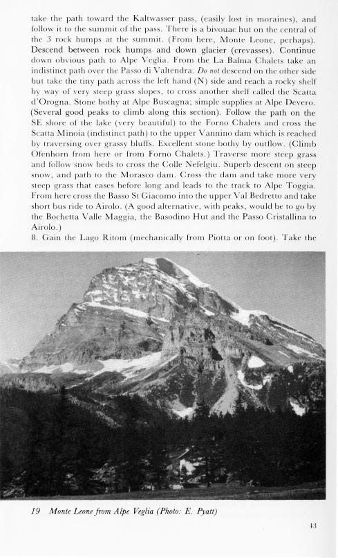
take the path toward lhe Kalt\ as 'Cl' pa s, (asil lost in moraincs), andfollow it to the summit of Ihe pas, There is a bivouac hUI Oil the c 'ntral oflhe 3 rock humps al the summit. (From here, Jvlontc Leone, pcrhap ),Descend between rock hump and down glacier (crevas cs). C ntinueclown ob\'ious palh to Alpc eglia, From lh' La Balma ChaIL:lS lake anindistinct path over the Pas '0 di ahcndra, Do 1/01 de 'cend on the olher sidebut takc the tin path acro s the I 'ft hand ) sic! and I' 'ach a rocky shelfby wa)' of v ory steep 'rass slopes, to cro another 'helf called lh· 'callad'Orogna, lone bOlhy al Alpe Ruscagna; simple supplies al Alpe D'vero,(Several good peaks to climb along this section), Follow the path on lh
E shore of lhe lake \'ery beautiful) to lhe Forno ha lets ancl eras. lh 0
'calla inoia (indislinct path) la the upper \ annino darn which is rea 'h dby lra\'ersing over grassy bluffs, Excell nl Slone both)' b' oulll \ ,( lilllb
fenhorn frorn her or from Forno Chalels,) Traverse nlOre steep grassand follow sno becls 10 ross lhe Colle Nefclgiu, Superb de 'cenl on I psnow, 'Incl palh I the Morasco d'lnl, Cro s the darn and take mOre verysteep gra, lhal cases before long and leads lO lhe lrack 10 Alpe Toggia,From her' cross the Basso 't Ciacomo into lh' upper \ '11 B drellO and lakeshort bu ride 10 Airolo, (A good alternalive, with peah, would be 10 TO bythe Bochelta alle Maggia, Ihe Basodino Hut and the Passo Crislallina toAirolo,8, Cain Ihe Lago Ritonl (mechanically from Piolla or on fOOL), Take the
19 Monte Leol/efrom ALpe VegLia (Photo: E. Pyatt)
Passo Colombo and descend to Alpe Cassaccia on the Lukmanier passroad. From here a narrow steep path climbs over the Passo di Gana egraand descends easily to Campo Blenio (simple supplies). Follow the steeproad to the Luzzone dam and cross the sensational dam wall. Take therunnel beside the lake and follow a track to a small chalet. From here anarrow marked path leads to the caradra alp (beautiful camp site) andover the Soreda Pa s. Great care mu t be taken with the waymark in orderto find the steep loose gully that leads up to the pa . An unpleasant place.Descend following waymarks to Lantatal and a small unattended hut.Follow the path to one of the Rhine sources and take the true left handmoraine to gain level glacier at the foot of lope leading to the Lantallicke.
Either directly up a teep couloir to the col, or right acros teep snow to aridge of easy rock leading to a ubsidiary summit of the Rheinwaldhorn.(Summit reached easily, crevasses.) Descend to the Zapport Hut and atgreat length to Hinterrhein (no supplies) and Splligen. .
9. Reach Juf at the head of the Ferrera valley by bu . (This place can bereached in a roundabout way from Splligen over complicated hills). ReachMaloja by a fine grassy walk over the Forcellina, Septimer and Lunghinpas'e . Well marked path.
The next objective is the Marinelli Hut (and Piz Bernina). Either by thearduous Passo Muretto to Chiareggio and Chiesa (not recommended) or,weather permitting, by the SE shore of the lake and the VaI Fex, crossingthe Fex-Scerscen pass (a hut recently built there) and descending the
cer cen glacier to the moraines below the Marinelli hut. ( 0 detail.)Traverse over the Colle de Musella to the Bignami Hut at Alpe Fellaria,
and descend to the dam, from which an easy path leads up to the allePo chiavina. Fine camping. Cro the ea y' pass at its head and de cendteeply to Alpe Cancian (keeping to the left hand side of the valley on a faint
track). From the chalet take a network of tracks at length down toPo chiavo, through thick teep fore t. Take a bus to faxu; and from theremake a long teady walk through a plendid valley and pa t lake , to thePasso da aI Viola. Continue down a long and stony track to the road atArnoga. It i best to camp up near the pa . Occasional bu es go fromArnoga down to Bormio. It is better to wait than to walk. From Bormio, ashort bu ride to St Catarina and a steady walk by the Albergo Buzzi to theVaI Cedec. (Several summits here). Gain the Casati hut by a tiresomeslope of scree and snow above the end of the track (obvious). (From herethe Cevedale summit is ea ily reached.) Cro s the nowfield to theEis eejoch: the descent to ulden may be very tricky with large opencrevasses. If so, traverse NE behind a small shoulder and descend a broadsnow and then scree couloir. This leads down to below the crevassed ectionof the glacier, and on to a pleasant moraine and grassy shelf that leads downto the Val Martello. Good camping. No supplies in the VaI Martello, andfew buse .
( ote: The crossing of the Adige valley is the biggest single ob tacle. Onecan go either by atums and by bus to Kurzras, or walk over theSchlandraunertal to Kurzras (long and hard), or go by the Eisseejoch to
Sulden (conditions permitting) and thence by chluderns to the Armando
44
Diaz hut and cross a high col to Kurzras, (this last puts the Weisskugel inreach). I was offered a lift to Naturns and went that way.)la. Gain the Hochjoch. (Camp site below on th~ Italian side, or just'belowthe hut on the Austrian side. Weisskugel and Fineilspitze within reach.)From the Hochjoch either cross the Hauslabjoch to the Martin Busch Hutand descend to Vent, or descend to the Hochjoch Hospitz and follow theSeufertweg to the Vernagt Hut, from which several good climbs arepossible, and thence descend to Vent. From Vent, a short bus ride or walkdown to Solden.11. A long walk up the Windachtal to the Sieger!and Hut. (Climb theSonnklarspitze.) Continue over the Windachscharte and descend a faintpath to an abandoned military post. From here, gain the Gurtel Scharte (notrack but occasional waymarks; in bad weather very tricky route linding.)Descend into the next valley to some old mine workings and climb again tothe Schneebergscharte. Descend at length into the Ridnaunertal. (In goodweather, traverse the Sonnklarspitze and descend to the valley by way ofthe Becher Hut.) After a long walk (and hitch!) reach Sterzing.12. The valley of the Brenner Pass is another obstacle. Buses up thePlitschtal are rare and it is a long walk to its head. From the third hairpinon the Plitscherjoch road, take a narrow path toward the Hochfeiler. Thisleads over the Weisszint Scharte to the path that traverses the S flanks of theZillertal Range. (Sevel-al good peaks can be climbed.) There are excellentcamp sites at the foot of the S ridge of the Gr Moseler, and at Alpe Goger.Descend to StJohann or Luttach. There is no camping in this valley. Takea bus to Prettau (Predoi). Here are the last supplies for several days.13. Cross the Birnllicke. (The Drei Herrnspitze stands above it.) Descendlaboriously and climb steeply past the Warnsdorfer Hut to the KrimmlerTor!. (Good summits, e 'pecially the Hinter Maurer Kees Kopfwhich has asplendid long ridge descending to the col.) Cross easy glacier and makeanother laborious descent and climb past the Kursinger Hut. Good camp atglacier's edge. Traverse the Gross Venediger and the Rainer Horn to theBadener Hut (it is advisable to descend to the Badener Hut over the smallpeak known as the Krestallwand, since the Frossnitz glacier is a 'nasty' forthe soloist). Thence a magnilicent walk down to Matrei. It is advisable tocamp in the beautiful upper valley. (A good alternative would be tocontinue from the Kursinger Hut over the Untersulzbach Tor! and take theSt Poltner high-level pathway to the Kaiser-Tauernhaus and then Kals.)From Matrei, walk over to Kals.14. Traverse the Gross Glockner from the Studl Hut, descending at lengthto Heiligenblut, or in bad weather take the Bergertor! into the upperLeitertal and descend from there.
The fast time in which [ was able to complete this traverse was due tobad weather, in which it was better to walk than to climb. It would be bestto take another week or la days, and to gain some large summits in theMont Blanc range and the Valais Alps. It is an incomparably line andexacting excursion, which ought to become a classic amongst those who likethis sort of thing.
45