Embed Size (px)
Citation preview

A Google Maps Mashups Tutorial
91.113-021Instructor: Michael Krolak
91.113-031Instructor: Patrick Krolak
See also http://www.cs.uml.edu/~pkrolak/
Authors: P. D. & M. S. Krolak Copyright 2005

Tonight
Source: http://blog.outer-court.com/files/google-cartoon-02.gif

Examples of Google maps
Google Maps (GM) is one of the best examples of commercial geospatial Internet applications. GM displays map and satellite imagery with local search based on map focus.

Nations 25 worst cities by crime rate

Houston online Crime Statistics
A free, browsable database of H crimes.
• Crimes may be viewed by offense, date, neighborhood, police district and beat, zip code, and political district.
• Uses Google Maps and H-area GIS data.
Source: http://www.hcrimemaps.com/

Online Crime Statistics in Chicago
• This is a browsable database of crimes reported in Chicago, Il
• The geographic maps display location and report details by time frame, crime type, street, zip code, ward, or route.
Source: http://www.chicagocrime.org/map/

Online Crime Stats Washington D.C.
• Another Google Mash-up that links crime statistics to map locations and puts them online.
• The user can get crime detail and statistics in tabular form and in RSS.
Scource: http://www.crimeindc.org/

HYDESIM ground level nuclear blast
Source: http://meyerweb.com/eric/tools/gmap/hydesim.html

USPS Zipcode mashup
Source: http://www.usnaviguide.com/zip.htm
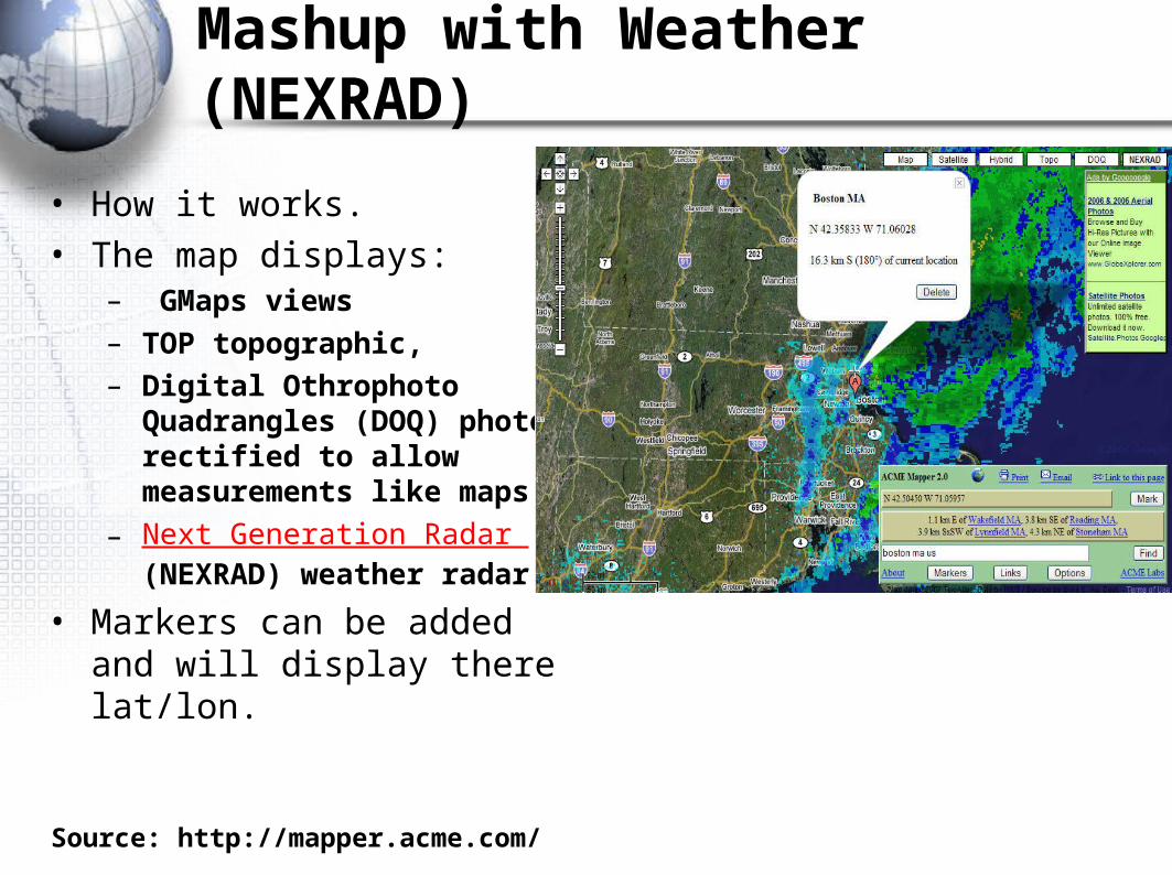
Mashup with Weather (NEXRAD)
• How it works.• The map displays:
– GMaps views – TOP topographic, – Digital Othrophoto
Quadrangles (DOQ) photos rectified to allow measurements like maps,
– Next Generation Radar (NEXRAD) weather radar
• Markers can be added and will display there lat/lon.
Source: http://mapper.acme.com/
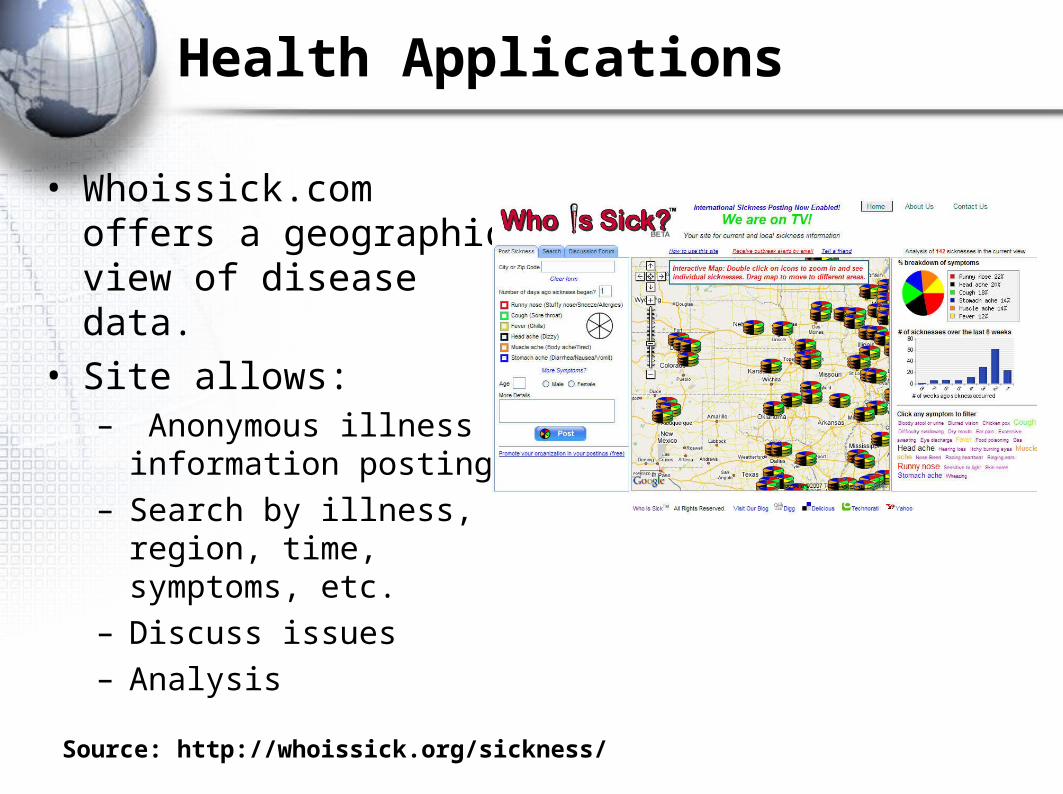
Health Applications
• Whoissick.com offers a geographic view of disease data.
• Site allows:– Anonymous illness
information posting– Search by illness, region,
time, symptoms, etc.– Discuss issues– Analysis
Source: http://whoissick.org/sickness/
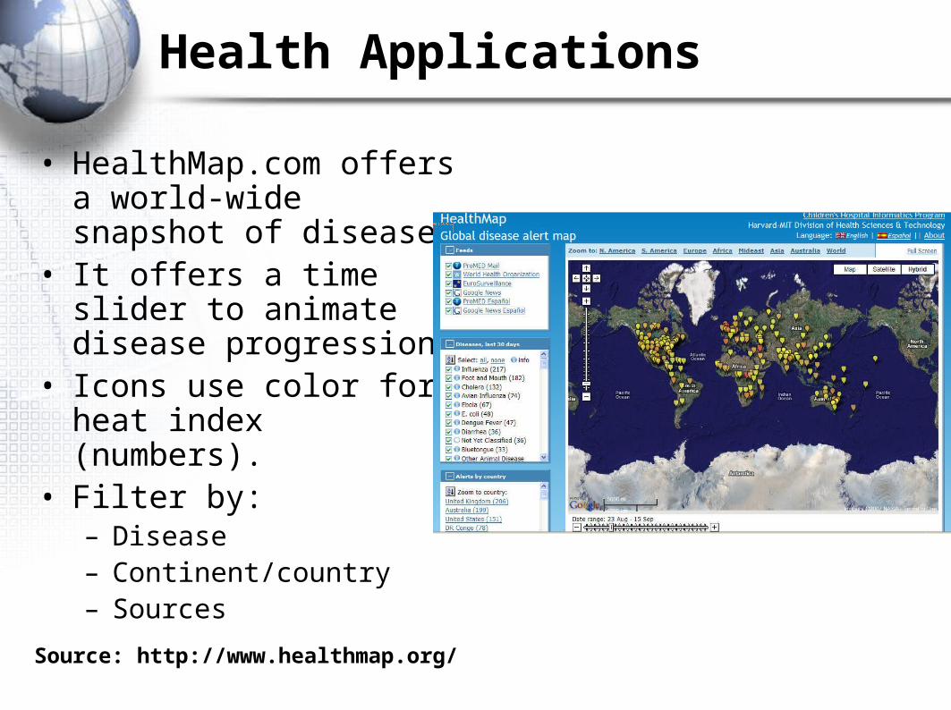
Health Applications
• HealthMap.com offers a world-wide snapshot of disease.
• It offers a time slider to animate disease progression.
• Icons use color for heat index (numbers).
• Filter by:– Disease– Continent/country– Sources
Source: http://www.healthmap.org/
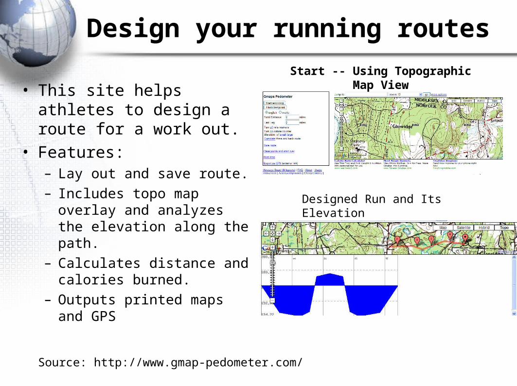
Design your running routes
• This site helps athletes to design a route for a work out.
• Features:– Lay out and save route.– Includes topo map overlay
and analyzes the elevation along the path.
– Calculates distance and calories burned.
– Outputs printed maps and GPS
Source: http://www.gmap-pedometer.com/
Start -- Using Topographic Map View
Designed Run and Its Elevation

Traffic Cam Applications
• Photoenforced.com gives the driver the location of red light traffic cams in major cites.
• Check before you travel.
Source: http://www.photoenforced.com/ny.html

Mashup – The Media and Gmaps
• MediaScrape, the Internet TV News Network http://www.MediaScrape.com, announces revenue-sharing deals with SCTV (Indonesia); AL Quds TV (Palestine); The Media Line (Israel); TV Brussels and the CBC (Canada).
• MediaScrape also releases today its Google Maps integration that enables its users to find breaking news videos through Google Maps.
• MediaScrape's broadcast news partners include the BBC, CBC, Asia News International, and 25 other leading global news broadcasters. "Our revenue-sharing deals with new broadcasters will join the revenue- share deals that we have with major search portals for our existing database of 35,000 news videos.
• Clearly, the world's desire to watch our global broadcast news partners' video is growing. We will be adding translation in multiple languages in the coming weeks to grow our syndication audience base further," says Tyler Cavell, Publisher of MediaScrape. MediaScrape currently broadcasts over 150 breaking news videos, 24/7, from its editorial and translation bureaus in over 11 countries.
Source: http://www.MediaScrape.com

Google Street View
Street View involves taking the viewer for a video tour of a street.
1. Original concept maybe due to Richard Miner and John Buford at the CPE, UMass Lowell.
2. Other examples are the Paris street tour and the more ambitious and the A9.com map project now abandoned.
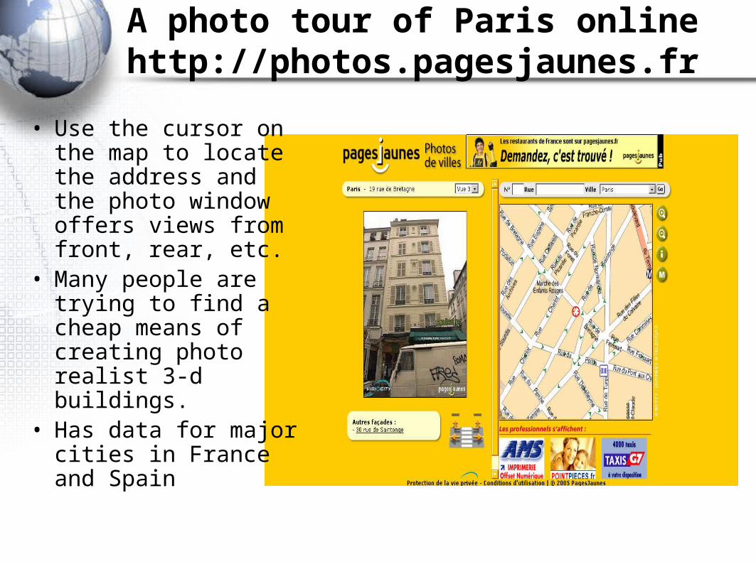
A photo tour of Paris onlinehttp://photos.pagesjaunes.fr
• Use the cursor on the map to locate the address and the photo window offers views from front, rear, etc.
• Many people are trying to find a cheap means of creating photo realist 3-d buildings.
• Has data for major cities in France and Spain

Amazon.com’s A9.com maps
Amazon.com has created an interesting entry in the geographic information search & display
The map is used to locate city blocks of interest and which then allows the viewer to see accurate street level photos to locate the traveler.
Amazon.com has abandoned this concept.

A9 DisplayLeft side lets viewer move along st. and right shows street level view
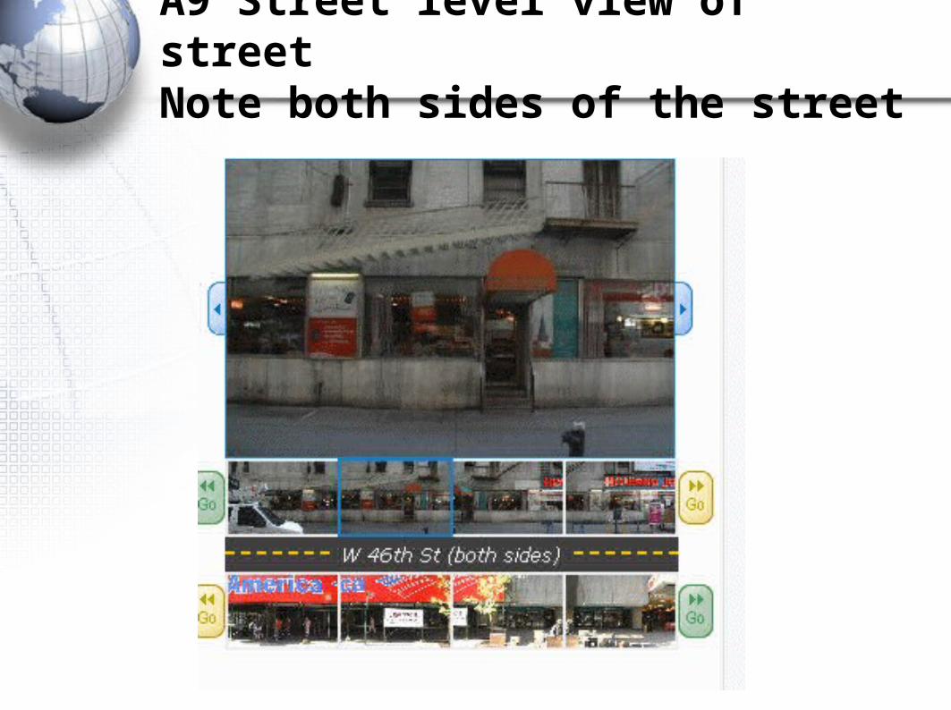
A9 Street level view of street Note both sides of the street

Google Street View
What is Street View? • Click [Street View] button
and cities where the street view feature is supported appear as cameras.
• Click on a camera to tour streets in the town.

Create your own mashup

First step
1. Go to http://www.google.com/apis/maps/index.html and register your website.
1. You need a google account. If you have google gmail you already have one.
2. The directory that you register is http://ceweb.uml.edu/YOUR_USER_ID
3. You will receive a key (a sting of numbers and letters) that will allow your mashup to work.

Second step.

Sources of Data in GMAP
• Google Ocean – Marine data for Google Maps/Earth – http://www.justmagic.com/GM-GE.html


![[Jaranowski P., Krolak a.] Analysis of Gravitation(BookFi.org)](https://img.pdfslide.us/doc/110x75/55cf8a9955034654898c23a6/jaranowski-p-krolak-a-analysis-of-gravitationbookfiorg.jpg)