Embed Size (px)
Citation preview

A Glimpse of AustraliaAuthor(s): Andrew C. LawsonSource: The Scientific Monthly, Vol. 27, No. 3 (Sep., 1928), pp. 244-259Published by: American Association for the Advancement of ScienceStable URL: http://www.jstor.org/stable/7980 .
Accessed: 08/05/2014 06:03
Your use of the JSTOR archive indicates your acceptance of the Terms & Conditions of Use, available at .http://www.jstor.org/page/info/about/policies/terms.jsp
.JSTOR is a not-for-profit service that helps scholars, researchers, and students discover, use, and build upon a wide range ofcontent in a trusted digital archive. We use information technology and tools to increase productivity and facilitate new formsof scholarship. For more information about JSTOR, please contact [email protected].
.
American Association for the Advancement of Science is collaborating with JSTOR to digitize, preserve andextend access to The Scientific Monthly.
http://www.jstor.org
This content downloaded from 169.229.32.137 on Thu, 8 May 2014 06:03:07 AMAll use subject to JSTOR Terms and Conditions
A GLIMPSE OF AUSTRALIA By Professor ANDREW C. LAWSON
UNIVERSITY OF CALIFORNIA
AUSTRALIA iS sliglhtly larger than the United States, but it has only about 5 per cent. of our population. It is a pas- toral and agricultural country, the early development of which, like that of Cali- fornia, was stimulated by a gold rush in the middle of the nineteenth century. Since the exhaustioni of its placers it has had some great mining camps, such as Mount Morgan, Broken Hill, Kalgoorlie and Cloneurry, the spectacular produc- tion of which has done much to make Australia famous. But to-day the metal mining industry is in a decline. Many of the great mines are either exhausted, or, having been gutted of their bonanza ore, are no longer profitable at present wage costs, and no new discoveries of rich ore bodies are being made. What- ever discoveries may be made in the future, their exploitation will lead to the exhaustion exemplified in our own Com- stock, Goldfield and Cripple Creek. Their influence on the development of Australia, though surely beneficent, will be evanescent. When metal mining has become relatively unimportant and even negligible, the pastoral and agricultural resources of the land will remain and will continue to yield up their wealth to the people.
Coal is, however, abundant in the more populous regions of the continent, and there is sufficient iron for domestic needs. Up to the end of the nineteenth century nearly all manufactured goods used by the Australians were imported, but during the first quarter of the twen- tieth century there has been a steady growth of the manufacturing industry, representing the efforts of a self-con- tained and peculiarly isolated country
to supply its own needs. There is little doubt but that these efforts will be ex- tended, and that the general manufac- ture of goods for home consumption will gradually be developed.
The chief commodities which Austra- lia has to balance her long and costly list of imports are wool and wheat. The breeding of sheep to produce heavy yields of fine merino wool, and the pas- turing of these on a vast scale has been Australia 's great achievement and her most notable contribution to the world's economy. The acreage devoted to wheat is steadily increasing, and, notwith- standing the somewhat critical climatic conditions which prevail in the new ter- ritories being brought under the plow, it is probable that Australia will grow in importance as one of the world's granaries. In recent years there has been a large increase, also, of exports of dairy products.
A traveler's tale concerning this vast, thinly populated but vigorous country on the other side of the world is of course not to be trusted. Nevertheless, at the risk of confirming such skepti- cism, I propose to narrate some things concerning Australia which came to my attention during a recent journey across that continent.
I shall first sketch briefly' the physi- ography of the Australian continent, its relief, geological structure and climate, so that my readers may have a proper aDDreciation of the lure of the land in
1 Most of the facts here recited are well known to Australian geologists and geogra- phers, and this paper does not profess to be an 3riginal contribution to our knowledge of Australia but only a summary review of mat- Lers that should be better known.
Zltit
This content downloaded from 169.229.32.137 on Thu, 8 May 2014 06:03:07 AMAll use subject to JSTOR Terms and Conditions
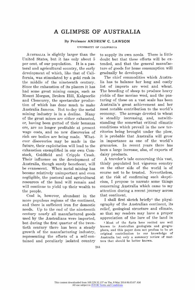
A GLIMPSE OF AUSTRALIA 245
4< WEST R N A U S T R A L I A i odsonT E R R I T R
9\(M\g
(
>Afeek8tharr,2 Ooo!~ I MdVO'u/4 f svoo
Cera;ldt e
SCALE Of MILES 0 as zX z 0, so CO no0 300 00f0 ST,(
A LVPTfIJ MAP AF ATTR AT.TA
ivhich has been eventually founded , strong Anglo-Saxon commonwealth ir the southern hemisphere, and knox something of the difficulties that havy been overcome, and have yet to be over come, in this remarkable extension o. the English-speaking people.
Compared with other continents th, relief of Australia is very subdued. T may be regarded as a tableland whici has been elevated somewhat at its east ern and southeastern margin. This marginal highland belt is commonly re ferred to as the Eastern Cordillera; anm there are, indeed, some mountains in i toward the south which have an Alpine character. Of these Mount Kosciuski is the most notable, having an elevatioi of 7,300 feet near the boundary betweei Victoria and New South Wales. But bi far the greater portion of the Easterr Cordillera is a dissected plateau, the residual mesas and ridges of which d(
not usually exceed four thousand feet in New South Wales, and half this in Queensland. The trend of this elevated belt is curved, with a pronounced con- vexity to the Pacific; and this convexity of the axis of uplift has determined the contour of the eastern coast of the con- tinent.
The descent to the sea on the east side of the uplift is abrupt, while on the west side, in the concavity of the curve, there is a very gentle slope to the lower plains of central Australia. The divide for the major drainage of the continent is thus at its eastern side. The streams to the east are short, and in their upper reaches flow in steep walled canyons; but as they leave these near the coast they pass into broad pleasant valleys. The intricate and deep dissection of this uplifted margin of the continent has given rise to an extremely rugged but picturesque country; so rugged in
This content downloaded from 169.229.32.137 on Thu, 8 May 2014 06:03:07 AMAll use subject to JSTOR Terms and Conditions
246 THE SCIENTIFIC AIONTHLY
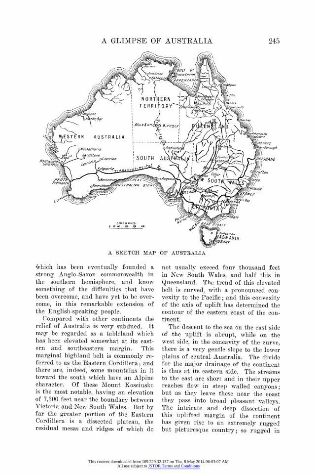
A RAILWVAY CUT AT ZANTHIJS, ON THE TRANSCONTINENTAL RAILWAY, SHOWING THE, CONCRETIONARtY CHARACTER OF THE SUB-SOIL UNDERt THE DRY BUT WOODED
C'ENTRAT PTAIN.S
New South Wales as to constitute a serious barrier to communication and transportation between the coast and the interior; so picturesque that it has be- come famous and has many colonies of summer homes on its commanding sum- mits.
On the west of the divide are the long rivers of the continent, and these drain three hydrographic basins. The largest and most important is that to the south traversed by the Murray and its tribu- tary, the Darling, flowing into the Southern Ocean about fifty miles from Adelaide. To the north, the hydro- graphic basin of the Flinders River and its tributaries drains the western slope to the Gulf of Carpentaria. Between these two lies a vast interior basin with no outlet to the sea. The chief rivers flowing from the divide into this basin are the Diamantina and Barcoo. Their waters are lost in Lake Eyre, a great desert evaporating pan partly occupied by saline residues, lying below sea level.
West of the Eastern Cordillera there ire only two other portions of the con- Jinent which attain an altitude of over -wo thousand feet. One of these com- prises the Mlount Lofty, Flinders and ther ranges in South Australia, extend- ng from the southern coast near Ade- aide with a meridional trend to the vicinity of Lake Eyre. The ridges xvhich comprise this highland tract are paralleled by longitudinal valleys of de- pression, in two of which lie Spencer 3ulf, Torrens Lake and the Gulf of St. Vincent. The highest point of the South Nustralian highlands is Mount Brown, vhich has an elevation of 3,100 feet.
rhe other high region is in the center )f the continent under the Tropic of Dapricorn. Here a very considerable trea, including the MacDonnell Ranges, s enclosed by the tw-o-thousand-foot ,ontour. All the rest of Australia, ex- wepting the island of Tasmania, is a vast lain. Of this plain the eastern third, ,omprising the middle or closed hydro-
This content downloaded from 169.229.32.137 on Thu, 8 May 2014 06:03:07 AMAll use subject to JSTOR Terms and Conditions
A GLIMIPSE OF AUSTRALIA 247
graphic basin and large parts of the southern and northern basins, is known as the Great Artesian Basin. It lies below the one-thousand-foot contour, and perhaps half of it is below five huin- dred feet. To the north it passes into the lowlands wlhich encircle the Gtulf of Carpentaria, which is itself a very shal- low sea. The Great Artesian Basin is underlain by undisturbed Mesozoic strata which afford storage for large quantities of underground water, and this has become an important factor in the settlement and utilization of this vast arid tract.
The western two thirds of the conti- nental plain has for the most part an altitude of from one thousand to one thousand five hundred feet. On the sotuth it forms the coast of the Great Australian Bight, where it presents an unbroken sea-cliff for many hundreds of miles to the Southern Ocean. On the west it breaks away with a steep front to a low, narrow, coastal plain at the shores of the Indian Ocean. On the northwest side of the continent, from about latitude 280 South to the Arafura Sea, the plain drops more irregularly but gently to the coastal lowlands. The contours of the land are deeply indented, the profiles are flat and there are many embayments of the coast. The rivers draining into these embayments are almost limited to the. coastal lowlands,
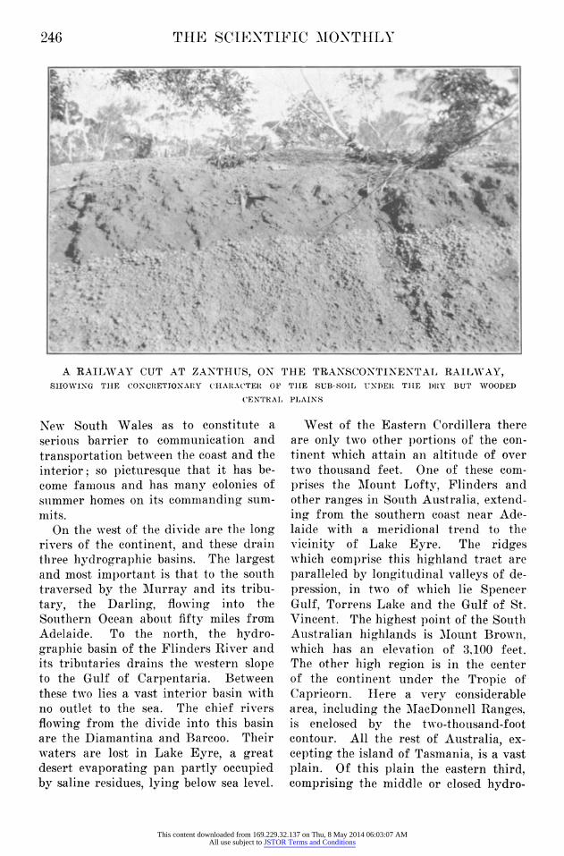
their headwaters not reaching far into the interior continental plain. Com- pared with the drainage from the west- ern flank of the Eastern Cordillera these rivers are therefore short, and appear as unimportant features on the general map of Australia. The general facts as to relief and drainage may be pictured if we think of the Appalachian .Mountains as the only watershed in the United States. From the eastern flank of this divide imagine a group of streams flowing to the Great Lakes, an- other group to the Gulf of Mexico, and the Ohio in between flowing westward to an evaporating basin in Oklahoma. Think of all the rest of the country be- tween Canada and MIexico as a dry, monotonous plain, devoid of rivers, ex- tending almost to the Pacific Coast, say as far as the Sierra Nevada and the Cascades. The hills known. as the Mac- Donnell ranges do, it is true, rise above the general level, but they only serve to accentuate the general appalling flatness of the continent. Where the transcon- tinental railway traverses this plain there is one portion of the track with negligible grades which is as straight as a stretched string for 330 miles without a bridge.
The explanation of these remarkable features of Australian physiography is of course to be found in the geological history of the continent. The greater
MAN SIN HOE AN UNEGON CHNNL INT WICTHSAN RIN PRMPL FLOW,
SO THAT THERE ARE NO WATER COURSES ON THE SURFACE
i E . , l W E l | X W.. 1~~~~~~~~~~~~~~~~~~~~~~~~~~~~~~~~~~~~~~~~~~~~~~~~~~~~~~~~~~~~~~~~~~~~. . . . . THE~~~~~~~~~~~~~~~~~~~~~~~~~~~~~~~~~~~~~~~~~~~~~~~~~~~~~~~~~~~~~. .ULRO ......LAIN .......... THE TREELESS WASTE THROUGH WHICH- THE TRANSCONTINENTAL RAILWAY RUNS FOR
HUNDREDS~~~~~~~~~~~~~~~~~~~~~..........
MANY TRELES WALSTEN THDROGHON HNESIT WHICH THE TRNCNINNACAILWA RAINS FOROPL HUNDRED
SO THAT THERE ARE NO WATER COURSES ON THE SURFACE
This content downloaded from 169.229.32.137 on Thu, 8 May 2014 06:03:07 AMAll use subject to JSTOR Terms and Conditions
248 THE SCIENTIFIC MONTHLY
. . .~~~~~~~~~~~~~~~~~~~~~~~~~~~~~~~~~~~~~~~~~~~~~~~~~~~~~~~~~~~~~. ...... ....
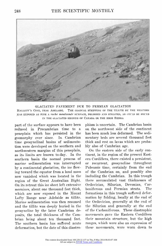
GLACIATED PAVEMENT DUE TO PERMIAN GLACIATION HALLETT 'S COVE, NEAR ADELAIDE. THE GRADUAL STRIPPING OF THE TILLITE BY THE WEATHER HAS EXPOSED AS FINE A roche mo'1Itonn&e SURFACE, POLISHED AND STRIATED, AS COULD BE FOUND
IN THE GLACIATED REGIONS OF CANADA OR THE HIGH SIERRA
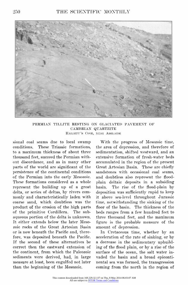
part of the surface appears to have been reduced in Precambrian time to a peneplain which has persisted in the geomorphy ever since. In Cambrian time geosynclinal basins of sedimenta- tion. were developed on the southern and northwestern margins of this peneplain, as its limits are known to-day. In the southern basin the normal process of marine sedimentation was interrupted by a continental glaciation, the ice flow- ing toward the equator from a land mass now vanished which was located in the region of the Great Australian Bight. On its retreat this ice sheet left extensive moraines, about one thousand feet thick, which are now exposed in the Mount Lofty Range near Adelaide as tillite. Marine sedimentation was then resumed and the tillite was deeply buried in the geosyncline by the later Cambrian de- posits, the total thickness of the Cam- brian being about ten thousand feet. The southern basin has suffered acuite deformation, but the date of this diastro-
phism is uncertain. The Cambrian basin on the northwest side of the continent has been much less deformed. The sedi- mentary beds are several thousand feet thick and rest on lavas which are proba- bly also of Cambrian age.
On the eastern side of the early con- tinent, in the region of the present East- ern Cordillera, there existed a persistent, or recurrent, geosyncline throughout Paleozoic time, certainly from the end of the Cambrian on, and possibly also including the Cambrian. In this trough there accumulated vast thicknesses of Ordovician, Silurian, Devonian, Car- boniferous and Permian strata. The formations in this trough suffered defor- mation by folding, locally at the end of the Ordovician, generally at the end of the Silurian and generally at the end of the Carboniferous. These diastrophic movements gave the Eastern Cordillera their mountain structure, but the high ranges, which were also an expression of these movements, were worn down to
This content downloaded from 169.229.32.137 on Thu, 8 May 2014 06:03:07 AMAll use subject to JSTOR Terms and Conditions
A GLIMPSE OF AUSTRALIA 249
low relief before the advent of Permian time; since there are widespread Per- mian formations over the region which exhibit little or no folding. The maxima for the thicknesses of the several divi- sions of the Paleozoic in eastern Aus- tralia as given by David, are: Ordovi- cian, 9,000 feet; Silurian, 4,000 feet; Devonian, 33,000 feet (including vol- canics); Carboniferous, 20,000 feet, and Permian, 15,000 feet (including volean- ics). The source of these vast volumes of sediment is an interesting question. It appears improbable that they came from the west, since the western part of the continent was a stable region of low relief, incapable of supplying sediments in large quantities. This makes it probable that the Paleozoic sediments were derived from a land mass which lay to the east of the present eastern coast of Australia. The core of the Fiji Islands, New Caledonia and perhaps New Zealand may be remnants of this almost vanished continental area. On this supposition of an eastern derivation of the Paleozoic sediments of Victoria, New South Wales and Queensland, the Eastern Cordillera becomes analogous to the Appalachian mountains, the Paleo- zoic sediments of which were derived from the land mass called Appalachia, now almost vanished beneath the waters of the Atlantic. And the analogy per- sists in the relation o-f the antecedent geosyneline to the Australian continent, and in the collapse of that trough toward the end of the Paleozoic, when it became overladen with sediments. Still another point of analogy is the fact that the Eastern Cordillera is in no sense the ranges which were formed at the time of the collapse, but are due to a more recent uplift of the region after those ranges had been reduced by erosion to low relief, just as the Appa- lachians are due to the post-Cretaceous uplift of the peneplain to which the ranges, formed at the time of the Ap- palachian Revolution, had been reduiced.
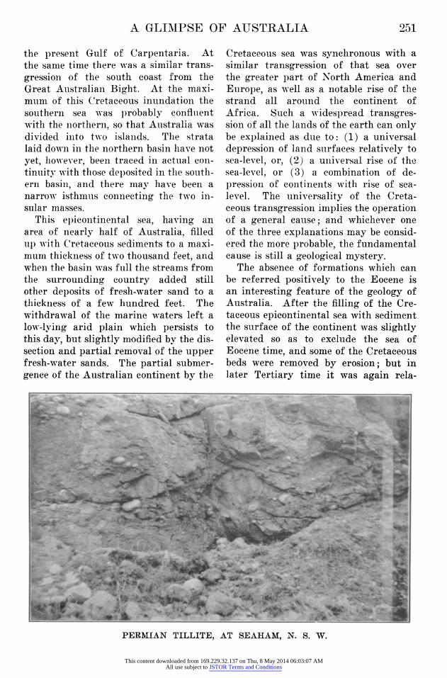
The Permian Period which followed after an interval of partial peneplana- tion was inaugurated by outpourings of volcanic lavas and by glacial conditions. A vast continental ice sheet overrode the greater part of the continent, perhaps more than once, advancing from the region of the present Great Australian Bight, which must then have been a land area. On its retreat, or retreats, this ice left morainic sheets which now appear as tillite at many widely spaced locali- ties in the basal division of the Permian. And these tillites may be seen to rest upon scored and polished roches mou- torneies pavements as perfect as any due to the Pleistocene glaciation of North America, or to the Alpine glacia- tion of the Sierra Nevada. This wide- spread glaciation of Australia was con- temporaneous with a similar glaciation of South Africa, South America and India and was a manifestation of glacial climate far more extensive than that of the Pleistocene. I-t is remarkable that, though the evidence of this Permian glaciation is abundant in the several continents, it is all found in regions much closer to the equator than to the poles. The relatively small extent of the land areas in the southern hemisphere may explain this fact south of the equator; but in the northern hemisphere Permian rocks are widely distributed and are well known, yet the evidence of Permian glaciation is scant and such as has been found is nearer the equator than the North Pole. Immediately after this glacial epoch conditions prevailed which were favorable to the accumula- tion of coal, and the principal coal mea- sures of Australia are in the upper divi- sion of the Permian.
In early Mesozoic time certain parts of the present Eastern Cordillera were the site of the accumulation of fresh- wate'r beds, chiefly fluviatile, as shown by the common crossbedding of the sandstones, but in part lacustral, as in- dicated by shales, and comprising occa-
This content downloaded from 169.229.32.137 on Thu, 8 May 2014 06:03:07 AMAll use subject to JSTOR Terms and Conditions
250 THE SCIE-NTIFIC M1ONTHLY
PERMIAN TILLITE RESTING ON GLACIATED PAVEMENT OF CAMBRIAN QUARTZITE
HALIJETT 'S COVE, NEAR ADELAIDE
sional coal seams due to local swamp conditions. These Triassic formations, to a maximum thickness of about three thousand feet, succeed the Permian with- out discordance, and as in many other parts of the world are significant of the persistence of the continental conditions of the Permian into the early Mesozoic. These formations considered as a whole represent the building up of a great delta, or series of deltas, by rivers com- monly and characteristically laden with coarse sand, which doubtless was the product of the erosion of the high parts of the primitive Cordillera. The sub- aqueous portion of the delta is unknown. It either extends below the later Meso- zoic rocks of the Great Artesian Basin or is now beneath the Pacific and, there- fore, was deposited beneath the Pacific. If' the second 'of these alternatives be correct then the eastward extension of the continent, from which the Paleozoic sediments were derived, had, in large measure at least, been engulfed not later than the beginning Qf the Mesozoic.
With the progress of MIesozoic time, he area of depression, and therefore of ;edimentation, shifted westward, and an ,xtensive formation of fresh-water beds tccumulated in the region of the present ?reat Artesian Basin. These are chiefly ;andstones with occasional coal seams, mnd doubtless also represent the flood- )lain deltaic deposits in a subsiding )asin. The rise of the flood-plain by leposition was sufficiently rapid to keep t above sea-level throughout Jurassic ime, notwithstanding the sinking of the loor of the basin. The thickness of the eds ranges from a few hundred feet to ;hree thousand feet, and the maximum Igure- is the probable measure of the mmount of depression. In Cretaceous time, whether by an
mcceleration of the- rate of sinking, or by i decrease in the sedimentary upbuild- ng of the flood plain, or by a rise of the ;urface of the ocean, the salt water in- vaded the basin and a broad epiconti- .iental sea was formed, the transgression ,oming from the north in the region of
This content downloaded from 169.229.32.137 on Thu, 8 May 2014 06:03:07 AMAll use subject to JSTOR Terms and Conditions
A GLIMPSE OF AUTSTRATIA 951
the present Gulf of Carpentaria. Al the same time there was a similar trans- gressioni of the south coast from th( Great Australian Bight. At the maxi. mum of this Cretaceous inundation th( southern sea was probably conflueni with the northern, so that Australia was divided inito two islands. The strata laid down in the northern basin have nol yet, hoNwever, been traced in actual conl tinuity with those deposited in the south. ern basin, and there may have been a narrow isthmuis connecting the two in- sular masses.
This epicontinental sea, having ay area of nearly half of Australia, filled up with Cretaceous sediments to a maxi- mum thickness of two thousand feet, and when the basin was full the streams fron the surrounding country added still other deposits of fresh-water sand to a thickness of a few hundred feet. Th( withdrawal of the marine waters left a low-lying arid plain which persists ta this day, but slightly modified by the dis- section and partial removal of the uppei fresh-water sands. The partial submer. gence of the Australian continent by the
Cretaceous sea was synchronous with a similar transgression of that sea over the greater part of North America and Europe, as well as a notable rise of the strand all around the continent of Africa. Such a widespread transgres- sion of all the lands of the earth can only be explained as due to: (1) a universal depression of land surfaces relatively to sea-level, or, (2) a universal rise of the sea-level, or (3) a combination of de- pression of continents with rise of sea- level. The universality of the Creta- ceous transgression implies the operation of a general cause; and whichever one of the three explanations may be consid- ered the more probable, the fundamental cause is still a geological mystery.
The absence of formations which can be referred positively to the Eocene is an interesting feature of the geology of Australia. After the filling of the Cre- taceous epicontinental sea with sediment the surface of the continent was slightly elevated so as to exclude the sea of Eocene time, and some of the Cretaceous beds were removed by erosion; but in later Tertiary time it was again rela-
AN. . .. .
PEMA TGLT AT SEHA I Si
._1"I
PERMI[AN TILLITE, AT SEAHAM, N. S. W.
This content downloaded from 169.229.32.137 on Thu, 8 May 2014 06:03:07 AMAll use subject to JSTOR Terms and Conditions
252 THE SCIENTIFIC MONTHLY
I~~ ~~ i1
aS I _ _3-~~~~~~~~~~~~~~~~~~~~~~~~~~~~~~~~~~~~~~~~~~~~~~~~~~~~~~~~~~~~~~~~~~~~~~~~~~~~~~~~~~~~~~~~~~~~~~~~~~~~~~~~~~~~~~~~~~~~~~~~~~~~~~~~~~~~~~~~~~~~~~~~~~A
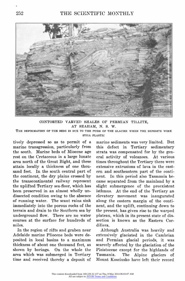
CONTORTED VARVED SHALES OF PERMIAN TILLITE, AT SEAHAM, N. S. W.
THE DEFORMATION OF THE BEDS IS DUE TO THE PUSH OF THE GLACIER WHEN THE DEPOSITS WERE
STILL PLASTIC
tively depressed so as to permit of a marine transgression, particularly from the south. Marine beds of Miocene age rest on the Cretaceous in a large lunate area north of the Great Bight, and these attain locally a thickness of Xone thou- sand feet. In the south central part of the continent, the diry plains crossed by the transqontinqfttal railway represent the uplifted Pary sea-floor, which has been preserved in an almost wholly un- dissected condition owing to the absence of running water. The scant rains sink immediately into the porous rocks of the terrain and drain to the Southern sea by underground flow. There are no water courses at the surface for hundreds of miles.
In the region of rifts and graben near Adelaide marine Pliocene beds were de- posited in local basins to a maximum thickness of about one thousand feet, as shown by borings. On the whole the area which was submerged in Tertiary time and received thereby a deposit of
marine sediments was very limited. But this defect in Tertiary sedimentary strata was compensated for by the gen- eral activity of volcanoes. At various times throughout the Tertiary there were extensive extrusions of lava in the east- ern and southeastern part of the conti- nent. In this period also Tasmania be- came separated from the mainland by a slight submergence of the preexistent isthmus. At the end of the Tertiary an elevatory movement was inaugurated along the eastern margin of the conti- nent, and the uplift, continuing down to the present, has given rise to the warped plateau, which in its present state of dis- section is known as the Eastern Cor- dillera.
Although Australia was heavily and extensively glaciated in the Cambrian and Permian glacial periods, it was scarcely affeeted by the glaciation of the Pleistocene except for the highlands of Tasmania. The Alpine glaciers of Mount Kosciusko liave left their record
This content downloaded from 169.229.32.137 on Thu, 8 May 2014 06:03:07 AMAll use subject to JSTOR Terms and Conditions

A GLIMPSE OF AUSTRALIA 253
of refrigeration, but there was no con- tinental ice-sheet anywhere in Australia. This fact serves to bring out the relative intensity of the early glaciations com- pared with that of the Pleistocene in the Southern Hemisphere, and the contrast is independent of the factor of altitude, since there is no evidence that the Aus- tralian continent was notably higher within its present confines in Cambrian and Permian times than it is to-day. But while Australia was not glaciated in Pleistocene time it was affected indi- rectly by the development of continental ice-sheets in other parts of the world. These ice-sheets were so extensive and so thick that the abstraction of water from the ocean to form them lowered the sur- face of the sea and permitted the streams to cut valleys in the continental margins to lower levels than before or after glaciation. When the water was re- stored to the sea by the melting of the great ice-sheets the surface of the sea rose and invaded the valleys. Drowned
valleys in the shape of splendid harbors are thus characteristic of the coast of Australia, particularly its east and southeast coast. But from the end of the Tertiary down to the present there has been in progress a slow elevatory movement of the eastern margin of the continent. The drowned valleys show that the rate of this uplift has been slower than the rate of down cutting of the valleys. But however slow it may have been, it is apparent that the strand of the sea, as restored by the melting of the last glaciers, would not reach so high on the coastal slope as did the earlier strand before the sea surface was low- ered. That earlier strand would, there- fore, be expected as a geomorphic fea- ture of the coast above the present func- tional strand. Such elevated strands are a common feature of the east coast of Australia at about fifteen feet above sea- level, and their altitude may be taken as a measure of the amount of uplift to which the coast has been subjected in the
BROADSIDE VIEW OF THE DARLING FAULT SCARP ON WHICH THE WESTERN MARGIN OF AUSTRALIA, NEAR PERTH, HAS BEEN DROPPED ABOUT 1,000 FEET. ON THE SURFACE OF THE DROPPEID BLOCK DELTAIC ALLUVIATION HAS BUILT UP THE COASTAL
This content downloaded from 169.229.32.137 on Thu, 8 May 2014 06:03:07 AMAll use subject to JSTOR Terms and Conditions
25i4 THIE S4CIENTIFIC MONTIHTY
interval of the last lowering of the sea surface.
It has been suggested that, jnst as the Paleozoic sediments of the Appal,achian trough were derived from the waste of the land mass of Appalachia, which has since for the most part sunk beneath the Atlantic, so the Paleozoic sediments of the East Australian trough were derived from a land mass to the east of the pres- ent continent, which has since almost entirely sunk below the Pacific. The Permian glaciation suggests the former existence of a large land mass in the Great Australian Bight. This fragmen- tation of the primitive Australian con- tinent and the shrinkage of its area by the foundering of its periphery are further indicated by movements of later date. The Darling fault scarp of West- ern Australia, a post-Tertiary feature, is clearly due to the dropping away from the continental plateau of a coastal block, upon the depressed surface of which has been built up the present coastal plain by the extension of stream deltas and the counter extension of dunes from the shore. The Sterling Range fault, in the southwest corner of Western Australia, is an expression of the dislocation of that corner from the main plateau, with downthrow seaward to the southwest. The abrupt change of level, between the southern margin of the continental shelf and the sea-floor of the Great Bight, suggests a similar dropped block with no coastal plain, the fault lying far to seaward of the sea-cliffs. Since the southern margin of the con- tinent is here veneered by marine Mio- cene beds the dislocation and dropping of the block must be post-Miocene. The rifting in the vicinity of Adelaide, which resulted in Spencer Gulf, Vincent Gulf and Torrens Lake, is a manifestation of continental fragmentation, part of which at least is post-Tertiary. The coastal region about Melbourne has been dropped relatively to the interior pla- teau in post-Tertiary time by the Bac-
chus Marsh fault. The post-Miocene separation of Tasmania by the depres- sion of Bass-,strait appears to be another step in the fragmentation process. On the east side of the continent the post- Tertiary uplift of the plateau, which by dissection gave rise to the Eastern Cor- dillera, was accompanied by a relative depression of the coast. At the front of the Blue Mountains of New South Wales this was effected by a monoclinal fold. Parther south to the, west of Lake George the same displacement found expression in a fault indicated by the Cullarin scarp. In Queensland great normal faults with downthrow seaward are prominent features of the geological structure of the coast for over two thou- sand miles. The Great Barrier Reef is regarded by Australian geologists as sessile upon a dropped block.
It is thus evident that the Australian continent on the west, south and east presents a foundering coast to the ocean. As there is reason to believe that the southern extension of the continent from which the Permian glaciers moved north over more than half of the conti- nent has been engulfed, and that the land mass to the east, whence were de- rived the Paleozoic sediments, has been similarly engulfed, so we may see in the physiography and strueture of the coastal region good reason to believe that the process of foundering and engulf- ment is still going on. It is thus fairly certain that Australia is to-day but a remnant of its former extent, and that with the persistence of the process of fragmentation it will in the future be- come still smaller. What engulfment of the fragments means is a geological mystery, but there is many a fact that stares us in the face of which the same may be said. It is safe to say, however, that the fragmentation of the continen- tal margin is a process of adjustment to gravitative stresses due to progressive crustal instability. But this is merely
This content downloaded from 169.229.32.137 on Thu, 8 May 2014 06:03:07 AMAll use subject to JSTOR Terms and Conditions
A GLIMPSE OF AUSTRALIA 200
a restatement of the problem. The mys- tery remains.
The distribuLtion of population and the nature of its industry in the continent thus geologically characterized are deter- mined largely by its climate. The two chief factors in the climatic control of man's migrations and activities are the humidity and temperature of the air. A brief reference will therefore be made to these, as they vary over the surface of Australia.
The south central part of the conti- nent, the area of which is not well de- termined but is between one quarter and one third of the whole surface, has a rainfall of less than ten inches. This arid country extends as a belt widening eastward from the shores of the Indian Ocean nearly to the longitude of Mel- bourne, ancd from the tropics to the shores of the Great Australian Bight. Concentric with the boundary of this central arid region is a belt, broad on the north and east but narrowing to nothing on the south, having a rainfall of between ten and twenty inehes. This belt comprises about one third of the area of the continent. Outside of this is a much narrower belt, with a rainfall of twenty to thirty inehes. - The remain- der of the continent, a little more than one tenth of its total area, adjacent to the coast, has a rainfall of over thirty inches.
The seasonal distribution of rains is important in its influence on agricul- ture. In the summner months from No- vember to April inclusive, the rains come in the north and the south is dry; while in the winter the south receives its rain and the north is dry. But in the coastal regions of Eastern Australia the rain is fairly evenly distributed throughout the year. The rain which falls in the wheat-growing season, April to October, is particularly valuable. Half a million square miles of Australia receive a rainfall of ten inches or more during these months, and this is the
limit of the wheat-growing area. If we assume that one quarter of this area, about 125,000 square miles, has a soil suitable for wheat, then at ten bushels per acre Australia could produce eight hundred million bushels of wheat. But fallowing and rotation of crops would reduce this to four million bushels an- nually. And the average yield would be still farther reduced by occasional crop failure due to drought. The recogni- tion of the fact that wheat may be grown in regionis of very scant rains if those rains come in the growing season has led to a great extension of this branch of agriculture in recent years, particularly in South Australia and Western Austra- lia. The present production of wheat in Australia is about one hundred million bushels.
A rainfall of ten inches or more, with- out regard to the season of its fall, has generally been held to determine the area suitable for the pasturing of sheep. Thus in those regions where the rains fall from April to October the pastoral industry now meets the competition of agriculture for the utilization of the land. The shepherd generallv yields to the farmer and is turning more and more to the interior desert for pasture for his increasing flocks. This larger utilization of the desert for pasturage has been made possible in recent years by the extensive development of artesian water in regions where there is no water at the surface, although there may be adequate vegetation to sustain flocks of sheep.
Two thirds of the area of Australia is in the so-uth temperate zone and one third is in the tropics. For the two hot- test months of January and February the mean temperature in the tropics is from eighty to eighty-five degrees, while in the temperate zone it is from sixty- five to seventy degrees. For the coldest month, July, the miean temperature in the tropics is less than seventy-five de- grees, and in the temperate zone less
This content downloaded from 169.229.32.137 on Thu, 8 May 2014 06:03:07 AMAll use subject to JSTOR Terms and Conditions
256 THE SCIENTIFIC MONTHLY
than fifty degrees. The summer heat in the temperate zone is dry, and, owing to the clear skies which prevail, radiation is active, so that the nights are agreeably cool. In the tropics the prevailing tem- perature is favorable to sugar-cane, cot- ton and rubber in regions where the rainfall is ample. Of these the cultiva- tion of sugar-cane is an established in- dustry, particularly in Queensland, where there are many sugar mills. On the plate,au lands of the tropics, away from the coast, where the rainfall ex- ceeds twenty inches, cattle do well and there are many herds; but the business of exporting beef is at present suffering from the competition of the Argentine.
These general physiographic and cli- matic features of Australia have deter- mined the permanent concentration ol its population in the more humid and cooler coastal regions, while the great interior of the continent remains an un- inhabited desolate wilderness. As an illustrati,on of how real a barrier the desert is to migration it may be of inter- est to note that while the English spar- row flourishes in Eastern Australia, it has never been able to make its way across central Australia to the wesi coast. A few years ago two sparrowws were brought in a cage on a French shir to Fremantle, where they escaped. When this fact became known the entire populati,on of Western Australia was seized with a panic; all the guns in th( country were requisitioned and a greal hunt was organized. It was only wher the two poor sparrows were eventually shot dead and their carcasses properly identified by ornithological experts, thai the people with a great journalistic sigl of relief resumed their normal oceupa- tions. After many years the rabbit sue ceeded in getting across the desert, an( rabbit-tight fences were promptly buil across the western side of the continenl to hold him to the desert.
Man has been scarcely more successfu than the sparrow, and the well-waterec
fertile soils of the west coast have been peopled not by overland migrations, as in the ease of our middle west, but by ships as in the days when our goldseek- ers went around the Horn.
Like California Australia had its gold rush in the middle of the nineteenth cen- tury, and the temporary concentration of population thus occasioned was on the climatically agreeable eastern and southeastern side of the continent. The gold placers were found in regilons where the older metamorphic and granitic rocks form the terrane; and they were reached from harbors where Brisbane, New Castle, Sydney, Melbourne and Adelaide have- since established them- selves as great metropolitan and indus- trial centers. The exploitation of the placers led to prospecting for the sources of the gold which enriched them, and so gold-bearing quartz reefs were discov- ered and mining camps were founded on both sides of the continent, which have become famous for their output of bullion. These were all located in the same terranes of ancient metamorphic and granitic rocks, and were all tribu- tary to the griowing cities of the coast, including Perth on the west. The suc- cessful exploitation of the gold mines led to the discovery of ore bodies in which copper, lead, zinc, silver, tin and iron were the chief metals, and these were extensively worked as gold-mining gradually declined. The discovery of telluride gold ores at Coolgardie and Kalgoorlie on the western margin of the great interior desert and the remarkable output of the older Mt. Morgan mine in Queensland led to a great revival of in- terest in gold-mining at the beginning of the present century. These great mines have been prolific of gold for sev- eral decades, but are now approaching exhaustion of profitable ore. The mines at Kalgoorlie have built a substantial city in the desert, but only at the ex- pense of a thirty-inch steel pipe throuigh which the water is lifted from the coast
This content downloaded from 169.229.32.137 on Thu, 8 May 2014 06:03:07 AMAll use subject to JSTOR Terms and Conditions
A GLIMPSE OF AUSTRALIA 257
and pumped by relay stations for 350 miles into the dry interior. When the mines are eventually exhausted and abandoned, the major use for the water will be on the fertile soils farther west, and the hitherto flourishing city of Kal- goorlie will become not less desolate than the buried cities of the deserts of Turkes- tan. But even if the mining of gold were now to wholly cease in Australia, the stoppage would not endanger the prosperity of the country. In the sev- enty or eighty years during which gold- mining has flourished it has not only served as a stimulus to the influx of a population possessed of great vigor, and has exercised a notable control in the distribution of that population, but it has contributed in large measure to the building up of the great cities of the coast, and has supplied and happily dis- tributed the capital necessary for the establishment of more permanent pas- toral and agricultural industries.
Australia is fortunate in having in the region of dense population a most agree- able climate, fine harbors and vast quan- tities of excellent coal. The best coal is found in various horizons of the Permian near the eastern coast, but coal of less importance is also fouind in Mesozoic and Tertiary formations. This coal and the existence of iron within convenient reach has led to the establishment of a great steel plant at New Castle, about one hun- dred miles north of Sydney, on the coast. No oil has yet been found in the rocks of Australia, but the day is rapidly ap- proaching when it will be found profit- able to extract from coal all the gasoline needed for her automobiles and other gas engines, and the failure to find oil will cease to be a cause of chagrin.
The most notable industry of Austra- lia and her most important source of wealth is the growing of wool. The total number of sheep in Australia at the present time is reported to be about 106 million, or about twenty-four for every head of population. The flocks are lim-
ited in their distribution to regions where the annual rainfall is in excess of ten inches. Where that rainfall oc- curs in the winter months there is a steady tendency to use the land for wheat-growing and so restrict the pas- toral area. But this is more than com- pensated by the gradual extension of the pastoral area in the dry interior of the continent, particularly where water is obtainable from artesian sources. The development of underground supplies of water in the dry eastern central part of the continent is a notable feature of the economic progress of the country. Here a great basin of undisturbed Meso- zoic rocks extends from the Gulf of Car- pentaria across Queensland into north- ern New South Wales and South Australia, occupying more than one quarter of the area of the continent. This basin receives the drainage of the western flank of the Eastern Cordillera of Queensland, and the lower formations of the basin are saturated with water which promptly rises to the surface when these formations are pierced by borings. The utilization of this supply has made possible the establishment of sheep stations with vast flocks in regions where there is no surface water, although there is sufficient vegetation to support sheep. The supply is very large and borings are being steadily extended, but it is of course limited by the replenish- ment from the drainage of the Eastern Cordillera. When the annual draft on the underground supply equals the an- nual replenishment the limit will have been reached. So far as I am aware little or none of this artesian water is used for irrigation in agriculture, doubtless due to the remoteness of mar- kets and the lack of transportation facilities.
The steady growth of the pastoral in- dustry from the beginning of the nine- teenth century to the present and the remarkable improvement in the breeds of sheep and the quality of wool indicate
This content downloaded from 169.229.32.137 on Thu, 8 May 2014 06:03:07 AMAll use subject to JSTOR Terms and Conditions
259 THE SCIENTTFICT MONTTHTTY
that the altitude, climate and vegetatio of Australia are especially favorable t, the life of the animal which has con tributed so much to the prosperity of th country. There is every reason to be lieve that the production of high-grad wool will steadily increase for an in definite time; and this permanence an stability of the pastoral industry o course implies a very thinly populates land, with few settlements that could b called villages, very meager transporta tion facilities and very few roads sue] as are common in a farming country The interior region where sheep flouris] is and will always remain a wilderness and, although farmers in the agricultura districts nearer the coast have thei flocks, the great bulk of the wool come from the stations in the wilderness These stations in the interior are im mense holdings running into hundred of thousands and even millions of acre for individual concerns, which ar leased on a very small rental buat whic] are subject to ultimate subdivision an sale if the land proves available for agri culture. When we add to the dry shee] country the vast territory which is s, arid that it never can support flocks o herds the immensity of the wildernes relatively to the populated areas become most impressive.
Besides the production of wool th pastoral industry is the basis of a larg export trade in mutton, beef and hides which, however, owing to competition, i not at present so profitable as the woo trade.
In recent years Australia has mad notable advances in horticulture anm produces now not only an abundance o fruit for domestic consumption, but alsi some for export. The apples of Tas mania particularly are shipped in in creasing quantities to Europe. Th hardwoods of Western Australia hav also become an article of commerce.
The principal exports of Australib
arising from its productive industry are thus: wool, mutton, beef, hides, wheat, oils, specie, metals, fruit and hardwood. The principal imports are: clothing, manufactured metals, foods, Oregon pine, paper, drugs, alcoholic drinks, oils, leather, jewelry, earthenware and to- bacco. In its past history Australia has imported most of the necessities and luxuries of civilized life and has met these imports by the export of a few staple commodities in world-wide de- mand. To-day there is a pronounced tendency toward becoming more self- sufficient. Manufactures in great variety are being developed in the centers of dense population. The new steel plant at New Castle has been mentioned. This will greatly mi-nimize the imports of rails and structural steel and will supply steel for many manufactured ar- ticles that were formerly imported. The sugar mills of Queensland now supply sugar for the whole of the common- wealth. New woolen mills are meeting a part of the demand for woolen fabrics. Quarries, ceramic plants and cement mills are supplying the bulk of the build- ing materials used. The native woods are coming into more general use. Ma- chine shops, foundries and engineering works are common in the cities. The manufacture of vehicles, harness and saddlery dates from early days, but is now feeling the advent of the automo- bile. Of printing, engraving and the making of books there is no end. Furni- ture, bedding, upholstery, chemicals and drugs are produced in increasing quan- tities. The day is approaching when Australia will be relatively as self-suffi- cient from an economic point of view as the United States or Canada. Yet its deserts will always be inhospitable. Its physiography and climate determine that it will always be essentially a pas- toral and agricultural country, that it will always export wool and wheat. As its manufacturing self-sufficiency in-
This content downloaded from 169.229.32.137 on Thu, 8 May 2014 06:03:07 AMAll use subject to JSTOR Terms and Conditions
A GLIMPSE OF AUSTRALIA 259
creases its imports will more and more take the form of luxuries rather than the nrecessities of life.
The insular character of Australia, the concentration of its people near the coast and their dependence on the sea for touch with the rest of the world, have determined that it shall be a maritime nation. Their travel has always been by sea and all their commerce has been sea-borne. Surrounded by the sea the Australians have a sense of unity and unchangeable completeness of domain which is not found in Europe or Amer- ica. To them the sea is a kindly element which is part of their possessions. Throughout the nineteenth century be- fore the confederation of the separate colonies into the commonwealth there was a well-established coastwise trade between the various coastal cities, besides the overseas commerce. The facility which the sea afforded for travel and for commerce between these now great cities has had an interesting influence on railway construction. When rail- ways were first built in the middle of the nineteenth century little attention was paid to through traffic. The various colonies built their railways with little regard to what their neighbors were doing. The purpose of railway con- struction was to facilitate travel and the hauling of freight within the boundaries of each colony. Intereolonial travel and commerce by rail was not considered im- portant because the ships took care of that, though it would be interesting to know what hand the shipping interests
lad in the matter. The indifference to ;hrough or intereolonial traffic is clearly shown by the fact that each colony de- Iermined upon, and maintains to this lay, a railway gauge of its own. The gauge in Queenslaind is 3' 6", in New South Wales it is 4' 8'', in Victoria it is 3' 3" and in South Australia and West- 1rn Australia it is again 3' 6". The new .ranscontinental railway built by the Iommonwealth between Port Augusta rnd Kalgoorlie is the standard gauge I' 8k". The latter was built for political reasons as a condition of Western Aus- ralia's corming into the Confederation. It has been running now for several Fears, but there is no economic or busi- aess reasorL for its existence. Nobody ives in souith central Australia on the ine of the railway except the people Nvho run the railway. There is a small imount of transcontinental passenger ,raffic, most of it as part of the travel 3etween England and the cities of east- ,rn Australia; but there is no freight to 3arry. All freight goes by sea. Imagine l railway system in America trying to naintain itself without freight! And yet another transcontinental railway is low in process of construction from Port Akugusta to Darwin, although there is no more hope of freight for the new line ;han for the existing one. As long as -he people of Australia live along the toast so long will freight be shipped by ;ea from one part of the coast to an- )ther; and no railway dependent upon freight for its economic justification has i hope of survival.
This content downloaded from 169.229.32.137 on Thu, 8 May 2014 06:03:07 AMAll use subject to JSTOR Terms and Conditions