Embed Size (px)
Citation preview

Structural Analysis of Historic Construction – D’Ayala & Fodde (eds)© 2008 Taylor & Francis Group, London, ISBN 978-0-415-46872-5
A GIS platform on main natural hazards for Valparaíso city(Chile) and vulnerability studies for some historical constructionsand urban sectors
M. Indirli, F. Geremei, C. Puglisi & A. ScrepantiENEA, Italy
D. Blersch, L. Lanzoni, N. Lopez Izquerdo, E. Milani, M. Miglioli & G. SimoniniUniversity of Ferrara, Italy
M. MunariUniversity of Padua, Italy
F. RomanelliICTP, Abdus Salam International Centre for Theoretical Physics of Trieste, Italy
ABSTRACT: The Project “MARVASTO” (“Risk Management inValparaíso/Manejo de Riesgos enValparaíso,Servicios Técnicos”) started in March 2007. It is managed by ENEA, with the participation of Italian and Chileanpartners and the support of local stakeholders. Being the city declared patrimony of the humanity by UNESCOsince 2003, the goals of the project are the following: to evaluate the impact of main hazards (earthquake,tsunami, fire, and landslide); to provide a vulnerability analysis for three historical churches (San Francisco, LasHermanitas de la Providencia, La Matríz, made by various materials – masonry, concrete, wood and adobe –and located in different city sites) and for a pilot building stock in the Cerro Cordillera historical area, analyzingmore than 200 constructions; to suggest guidelines for future urban planning; to develop a GIS digital archive,well organized, user-friendly and easy to be implemented in the future, providing maps and scenarios of specificand multiple risk. In the paper, preliminary results are given, taking into account the in situ work of two missionsat Valparaíso (May and October–December 2007).
1 INTRODUCTION
1.1 The project MAR VASTO and its partnership
Most of the highly populated cities are prone to naturalhazards.The main catastrophes (varying in magnitude,frequency, duration, extent area, onset speed, spatialdispersion and temporal spacing) are earthquakes, vol-cano eruptions, landslides, tsunamis, coastal erosions,floods, hurricanes, etc. As for urban habitats, bothwild and human-induced fires should be included. Fur-thermore, the building vulnerability must be carefullyevaluated, especially for historical centers and monu-ments, to identify the integrated risk due to the abovementioned disasters.
The Project “MAR VASTO” (“Risk Manage-ment in Valparaíso/Manejo de Riesgos en Val-paraíso, Servicios Técnicos”, MAR VASTO 2007)started in March 2007, with coordination of ENEA(Italian Agency for New Technologies, Energy and
Environment), participation of several partners (Italy:University of Ferrara, Department of Architecture;University of Padua, Department of Structural andTransportation Engineering; Abdus Salam Interna-tional Centre for Theoretical Physics of Trieste;Chile: Valparaíso Technical University Federico SantaMaria, Civil Works Department; Santiago Universityof Chile, Division Structures Constructions Geotech-nics), and support of local stakeholders. Being Val-paraíso included since 2003 in the UNESCO WordHeritage List of protected sites, the project main goalsare the following: to collect, analyze and elaborate theexisting information, with a satisfying evaluation ofmain hazards; to develop a GIS digital archive, wellorganized, user-friendly and easy to be implementedin the future, with maps and scenarios of specific andmultiple risk; to provide a vulnerability analysis forthree historical churches (La Matríz, San Franciscodel Baron, Las Hermanitas de la Providencia, made
1277

by various materials – masonry, concrete, wood andadobe – and located in different city sites) and for abuilding stock in the Cerro Cordillera (partially insidethe UNESCO area), analyzing more than 200 construc-tions; to suggest guidelines for future urban planningand strengthening interventions.
1.2 An important collaboration Italy – Chile
During the last two missions at Valparaíso (May andOctober–December 2007), many local Organizationsstrongly cooperated to the in situ work of the fourteenexperts coming from Italy: above all, the Munic-ipality of Valparaíso (mainly the Heritage Office,“Oficína de Gestión Patrimoniál OGP”, providinglogistic and technical support of about twenty people,but also qualified personnel of Environment and Hous-ing Departments); the Ministry of Culture (“ConsejoNacional de la Cultura y Las Artes”); the RegionalAuthority (“Intendencia V Region Valparaíso”); theRegional Civil Defense (“OREMI”); the SHOA (“Ser-vicio Hidrográfico y Oceanográfico de la Armadade Chile”); Valpomío (“Programa de Recuperacióny Desarrollo Urbano de Valparaíso”; the Firemen(“Bomberos”) and the Sea Rescue (“Bote Salvavidas”)Corps of Valparaíso; city organizations (“Junta deVecinos” of the Cerro Cordillera and “Gerencia BarrioPuerto”, which is the historical district of the City);the Board of Architects of Valparaíso and otherprofessionals; the Police (“Carabineros de Chile”);Church Authorities and other Universities (“PontificiaUniversidad Catolica de Valparaíso”, “Universidadde Valparaíso”); the Valparaíso Italian Community.Finally, important was the contribution of the Geo-com Santiago team, which provided the laser-scannerequipment.
2 THE “MAR VASTO” PROJECT
2.1 A brief description of Valparaíso
Valparaíso represents a distinctive case of growth,inside a remarkable landscape, of an important PacificOcean seaport (over the 19th and 20th centuries), upto reaching a strategic importance in shipping trade,declined after the Panama Canal opening (1914).Thus,Valparaíso tells the never-ending story of a tight inter-action between society and environment, stratifyingdifferent urban and architectonic layers, sometimesstruck by disasters and always in danger. Certainly,the city is subjected to various natural hazards (seis-mic events, but also tsunamis, landslides, etc.) andanthropic calamities (mainly wild and human-inducedfires). These features make Valparaíso a paradig-matic study case about multi-hazard mitigation, andrisk factors must be very well evaluated during therestoration phases to be planned in the future (Fig. 1).
Figure 1. Valparaíso: hazards and safeguarded areas.
The Valparaíso morphology can be roughly dividedinto two main sectors: the flat harbour area and the hillquarters. Large neoclassic masonry buildings, someprevious colonial style constructions (still standingstructures spared by earthquakes and following fires)and more recent architectures take place in the com-mercial district, with straight streets, highways and railtracks parallel to the coast. A wide area is occupied bythe port facilities up to the waterfront. Otherwise, thesteep forty nine hills, cut by ravines (“quebradas”) andclimbed by narrow and snaky lanes, are deeply filledby small and squat houses, typically made by woodenframes, adobe panels and covered by zinc tinplate(“calamina”). Several old cable cars (“ascensores”)ascend the slope. The UNESCO protected district(“Barrio Puerto”) lies in the Valparaíso Southern partand embraces a sector which, starting from the flat,reaches the hills. In addition to the above said pervad-ing clustered homes, notable historical buildings arepresent (Indirli et al. 2006). It is worth noting that, inabsolute terms (UNPD 2002, Munich Re Group, 2004)the economic cost of disasters has been increasing overdecades; thus, innovative and integrated tools for riskassessment are necessary (Indirli 2007).
2.2 Project architecture
A summary of “MAR VASTO” is shown by Fig-ure 2. The horizontal lines give the “general purpose”activities (disaster hazard maps, surveys, urban plan-ning/vulnerability analyses, GIS architecture, mul-timedia tools and final proposals), while targetedinvestigations are reported in the two columns.
Being impossible to manage deep investigationsfor all the Valparaíso historical area (due to limitedresources in funds and time), a common decision withChilean partners and stakeholders has been taken onstructures/areas to be investigated with highest priority(Fig. 3):
– three important historical churches (“La Matriz”,“San Francisco del Barón”, “Las Hermanitas de
1278
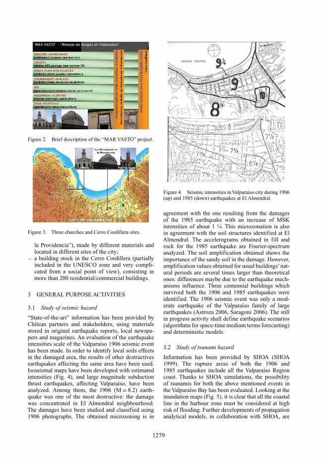
Figure 2. Brief description of the “MAR VASTO” project.
Figure 3. Three churches and Cerro Cordillera sites.
la Providencia”), made by different materials andlocated in different sites of the city;
– a building stock in the Cerro Cordillera (partiallyincluded in the UNESCO zone and very compli-cated from a social point of view), consisting inmore than 200 residential/commercial buildings.
3 GENERAL PURPOSE ACTIVITIES
3.1 Study of seismic hazard
“State-of-the-art” information has been provided byChilean partners and stakeholders, using materialsstored in original earthquake reports, local newspa-pers and magazines. An evaluation of the earthquakeintensities scale of the Valparaíso 1906 seismic eventhas been made. In order to identify local soils effectsin the damaged area, the results of other destructivesearthquakes affecting the same area have been used.Isoseismal maps have been developed with estimatedintensities (Fig. 4), and large magnitude subductionthrust earthquakes, affecting Valparaíso, have beenanalyzed. Among them, the 1906 (M = 8.2) earth-quake was one of the most destructive: the damagewas concentrated in El Almendral neighbourhood.The damages have been studied and classified using1906 photographs. The obtained microzoning is in
Figure 4. Seismic intensities in Valparaíso city during 1906(up) and 1985 (down) earthquakes at El Almendral.
agreement with the one resulting from the damagesof the 1985 earthquake with an increase of MSKintensities of about 1 ¼. This microzonation is alsoin agreement with the soil structures identified at ElAlmendral. The accelerograms obtained in fill androck for the 1985 earthquake are Fourier-spectrumanalyzed. The soil amplification obtained shows theimportance of the sandy soil in the damage. However,amplification values obtained for usual buildings’nat-ural periods are several times larger than theoreticalones: differences maybe due to the earthquake mech-anisms influence. Three centennial buildings whichsurvived both the 1906 and 1985 earthquakes wereidentified. The 1906 seismic event was only a mod-erate earthquake of the Valparaíso family of largeearthquakes (Astroza 2006, Saragoni 2006). The stillin progress activity shall define earthquake scenarios(algorithms for space-time medium terms forecasting)and deterministic models.
3.2 Study of tsunami hazard
Information has been provided by SHOA (SHOA1999). The rupture areas of both the 1906 and1985 earthquakes include all the Valparaíso Regioncoast. Thanks to SHOA simulations, the possibilityof tsunamis for both the above mentioned events inthe Valparaíso Bay has been evaluated. Looking at theinundation maps (Fig. 5), it is clear that all the coastalline in the harbour zone must be considered at highrisk of flooding. Further developments of propagationanalytical models, in collaboration with SHOA, are
1279
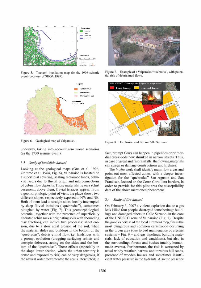
Figure 5. Tsunami inundation map for the 1906 seismicevent (courtesy of SHOA 1999).
Figure 6. Geological map of Valparaíso.
underway, taking into account also worse scenarios(as the 1730 seismic event).
3.3 Study of landslide hazard
Looking at the geological maps (Gna et al. 1996,Grimme et al. 1964, Fig. 6), Valparaíso is located ona superficial covering, sealing reclaimed lands, collu-vial layers due to fluvial origin and interconnectionsof debris flow deposits. Those materials lie on a schistbasement; above them, fluvial terraces appear. Froma geomorphologic point of view, the place shows twodifferent slopes, respectively exposed to NW and NE.Both of them lead to straight sides, locally interruptedby deep fluvial incisions (“quebradas”), sometimesploughed by water (Fig. 7). This geomorphologicalpotential, together with the presence of superficiallyalterated schist rocks (originating soils with aboundingclay fraction), can induce two processes: sheet ero-sion, due to a slow areal erosion of the soil, whenthe material slides and buildups in the bottom of the“quebradas”; debris e mud flow, i.e. landslides witha prompt evolution (dragging surfacing schists andantropic debrees), acting on the sides and the bot-tom of the “quebradas”. Those effects (especially inthe slope lower section, where the urban territory isdense and exposed to risk) can be very dangerous, ifthe natural water movement to the sea is interrupted; in
Figure 7. Example of a Valparaíso “quebrada”, with poten-tial risk of debris/mud flows.
Figure 8. Explosion and fire in Calle Serrano.
fact, prompt flows can happen in pipelines or primor-dial creek-beds now shrinked in narrow streets. Thus,in case of great and fast rainfalls, the flowing materialscan sweep or damage constructions and lifelines.
The in situ work shall identify main flow areas andpoint out most affected zones, with a deeper inves-tigation for the “quebradas” San Agustin and SanFrancisco, located on the Cerro Cordillera borders, inorder to provide for this pilot area the susceptibilitydata of the above mentioned phenomena.
3.4 Study of fire hazard
On February 3, 2007 a violent explosion due to a gasleak killed four people, destroyed some heritage build-ings and damaged others in Calle Serrano, in the coreof the UNESCO zone of Valparaíso (Fig. 8). Despitethe good expertise of the local Firemen Corp, fire is themost dangerous and common catastrophe occurringin the urban area (due to bad maintenance of electricsystems – Fig. 9 – and gas pipelines, building mate-rials, lack of education and vandalism), but also inthe surroundings forests and bushes (mainly human-made events). Furthermore, the risk is worsened byusual windy weather, narrow and tortuous hill roads,presence of wooden houses and sometimes insuffi-cient water pressure in the hydrants. Also the presence
1280

Figure 9. Lighting cables in Valparaíso.
Figure 10. The San Francisco Church after the fire (1983).
Figure 11. Location of the points measured by DGPS.
of the close harbour facilities represents a further riskfactor. Moreover, important monuments were severelydamaged by past fires, as happened for the Church of“San Francisco del Baron” in 1983 (Fig. 10). Thus,in the framework of a cooperation with the ValparaísoFiremen Corp, the “MAR VASTO” project foresees astudy of the fire hazard, which is still in progress.
Figure 12. Pictures from GIS database.
3.5 Surveys
During the Valparaíso mission, several field surveyshave been carried out. Firstly, about fifty points havebeen measured by DGPS, to check the GIS coordinates(Fig. 11). The three churches and the Cerro Cordillerabuilding stock have been documented through pic-tures (architecture, urban planning, structural features,damage and maintenance).
A complete 3D laser scanner survey (again on thechurches) have been done, as shown in par. 4.2.
3.6 GIS development
The GIS geo-referenced database is the final out-put of the entire work and shall organize in clearand user-friendly maps the available data (cartogra-phy, satellital images, vectorial and raster thematictools, surveys, hazards, vulnerability analyses, etc.,see Fig. 12), focusing the global risk for the selectedchurches and the pilot area in the Cerro Cordillera. Infact, the original GIS architecture identified for theselected sector and heritage buildings could be easilyextended in the future to all the historical city, in theframework of further research stages. The GIS imple-mentation is still in progress and shall be available atthe end of the project activities.
3.7 Multimedia activities
All the in-field activities have been filmed. In par-ticular, during the work in the Cerro Cordillera, animportant interaction with the resident people (throughinterviews) has been developed, in order to explain theresearch goals and receive their feedback about riskawareness.
Two presentations of the “MAR VASTO” projecthave been carried out (an invited lecture at the con-ference “El terremoto de Valparaíso de 1906” in theframework of the VI Chilean Congress of Geotech-nics, held by the Pontificia Universidad Catolica of
1281
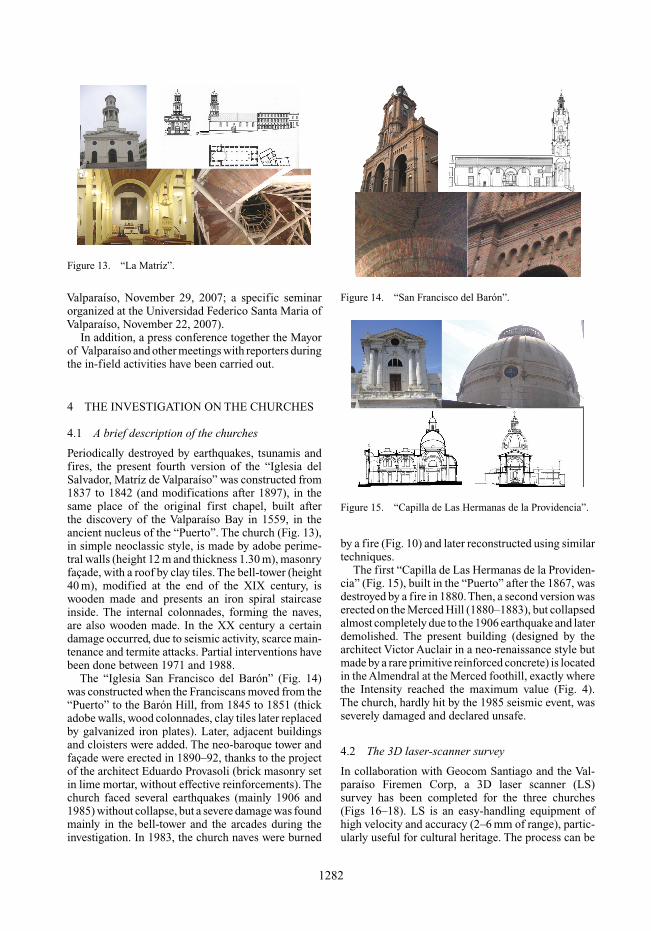
Figure 13. “La Matríz”.
Valparaíso, November 29, 2007; a specific seminarorganized at the Universidad Federico Santa Maria ofValparaíso, November 22, 2007).
In addition, a press conference together the Mayorof Valparaíso and other meetings with reporters duringthe in-field activities have been carried out.
4 THE INVESTIGATION ON THE CHURCHES
4.1 A brief description of the churches
Periodically destroyed by earthquakes, tsunamis andfires, the present fourth version of the “Iglesia delSalvador, Matríz de Valparaíso” was constructed from1837 to 1842 (and modifications after 1897), in thesame place of the original first chapel, built afterthe discovery of the Valparaíso Bay in 1559, in theancient nucleus of the “Puerto”. The church (Fig. 13),in simple neoclassic style, is made by adobe perime-tral walls (height 12 m and thickness 1.30 m), masonryfaçade, with a roof by clay tiles. The bell-tower (height40 m), modified at the end of the XIX century, iswooden made and presents an iron spiral staircaseinside. The internal colonnades, forming the naves,are also wooden made. In the XX century a certaindamage occurred, due to seismic activity, scarce main-tenance and termite attacks. Partial interventions havebeen done between 1971 and 1988.
The “Iglesia San Francisco del Barón” (Fig. 14)was constructed when the Franciscans moved from the“Puerto” to the Barón Hill, from 1845 to 1851 (thickadobe walls, wood colonnades, clay tiles later replacedby galvanized iron plates). Later, adjacent buildingsand cloisters were added. The neo-baroque tower andfaçade were erected in 1890–92, thanks to the projectof the architect Eduardo Provasoli (brick masonry setin lime mortar, without effective reinforcements). Thechurch faced several earthquakes (mainly 1906 and1985) without collapse, but a severe damage was foundmainly in the bell-tower and the arcades during theinvestigation. In 1983, the church naves were burned
Figure 14. “San Francisco del Barón”.
Figure 15. “Capilla de Las Hermanas de la Providencia”.
by a fire (Fig. 10) and later reconstructed using similartechniques.
The first “Capilla de Las Hermanas de la Providen-cia” (Fig. 15), built in the “Puerto” after the 1867, wasdestroyed by a fire in 1880.Then, a second version waserected on the Merced Hill (1880–1883), but collapsedalmost completely due to the 1906 earthquake and laterdemolished. The present building (designed by thearchitect Victor Auclair in a neo-renaissance style butmade by a rare primitive reinforced concrete) is locatedin the Almendral at the Merced foothill, exactly wherethe Intensity reached the maximum value (Fig. 4).The church, hardly hit by the 1985 seismic event, wasseverely damaged and declared unsafe.
4.2 The 3D laser-scanner survey
In collaboration with Geocom Santiago and the Val-paraíso Firemen Corp, a 3D laser scanner (LS)survey has been completed for the three churches(Figs 16–18). LS is an easy-handling equipment ofhigh velocity and accuracy (2–6 mm of range), partic-ularly useful for cultural heritage. The process can be
1282
Figure 16. Laser scanner at “La Matríz”.
Figure 17. Laser scanner at “San Francisco”.
Figure 18. Laser scanner at “Las Hermanas”.
divided in three steps: data acquisition (from severalstations which must be combined with care), geo-metric model creation, output elaboration (real statusarchives, Finite Element Models and plan, front, sec-tion drawings). The huge amount of materials is goingto be processed and will be very useful for structuralanalyses.
4.3 The analysis of seismic vulnerability
Damage and vulnerability have been evaluated byusing a well known Italian procedure, completing spe-cific survey forms conceived for churches (Molise2003). The procedure is based upon a qualitativeidentification of selected parameters (Fig. 19).
The more vulnerable damage mechanism in “LaMatríz” is n. 3 (façade in-plane mechanism), whilein “San Francisco” are n. 1, (out-of-plane façadeoverturning), n. 8 (triumphal arches), and n. 16 (bell-tower).
La “Capilla de Las Hermanas de la Providen-cia” is characterized by a lot of critical parameters:n. 2 (façade tympanum overturning), again n. 3, n.4 (transversal response of nave and transept), n. 9(dome), n. 11 (apse overturning), n. 12 (apse andpresbytery vaults), and n.13 (wall shear rupture).
Figure 19. Evaluation of damage and vulnerability.
In conclusion, “La Matríz” can be consideredin sufficiently good static conditions, but a generalrestoration is anyway suggested, for fire, materialsdegradation and termite attacks prevention. In “SanFrancisco”, an intervention on the bell-tower, whichshows worrying cracks, is needed and urgent with non-invasive antiseismic techniques. Finally, an immediateand global rehabilitation of the “Capilla” is absolutelynecessary, in order to prevent a possible collapse incase of strong earthquake.
5 THE SECTOR OF THE CERRO CORDILLERA
5.1 Introduction
Geo-referred hazard maps must interact with a detailedland and building inventory, in which urban planningand single construction features (architecture, struc-tural characteristics, vulnerability, real status, etc.) arelinked to the surrounding environmental and socialcontext (Indirli et al. 2006). A specific work, cross-ing urban planning and building vulnerability analysisfor the reconstruction of San Giuliano di Puglia afterthe earthquake, is presented at this SAHC Conference(Mazzanti et al. 2008).
The pilot zone of the Cerro Cordillera has beenselected in agreement with the OGP of the Val-paraíso Municipality. It is an historically “virgin”,socially complicated and poor sector, partially insidethe UNESCO area, and delimited by Calle Serrano(plan side), the San Agustin cable car upper station(hill side), and by the two opposite “quebradas” ofSan Francisco and San Agustin (Fig. 20).
5.2 Architectonic and urban planning analyses
The investigation interested 230 constructions, 4 pub-lic areas and about 50 road network stretches. Theinformation (architecture, function, structural condi-tion, quality, etc.) has been picked up through insitu surveys (by using special sheets elaborated for
1283

Figure 20. Cerro Cordillera investigation pilot sector.
Figure 21. Architectonic GIS database.
Valparaíso) and then stored in the GIS. Differentindexes properly overlapped (for example high archi-tectonic quality and bad conditions, see Fig. 21),enabled to identify rehabilitation priorities, in primisthe San Agustin cable car and its surroundings.
5.3 Vulnerability analyses
On the base of the above mentioned architectonic andurban planning GIS classification, prompt vulnera-bility analyses interested 70 structures of the Cerro
Figure 22. Cerro Cordillera units interested by vulnerabilityanalyses.
Cordillera pilot sector (Fig. 22), when exhaustivecadastral data were available (plans, prospects, sec-tions, construction details, geotechnical features, etc.),excluding informal and illegal houses. A special sheethas been elaborated, upon Italian established proce-dures (Aedes 2000, GNDT 1999), taking into account11 parameters (type and organization of the resistantsystem; quality of the resistant system; conventionalresistance; building position and foundations; hori-zontal elements; planimetry; elevation; maximum dis-tance between structural units, covering; non structuralelements; present situation). Thanks to preliminaryresults, almost one half of the analyzed units showsa high vulnerability index IV (22% 0 < IV < 30 lowvulnerability; 20% 30 < IV < 45; 16% 45 < IV < 60;42% 60 < IV < 100 high vulnerability).
6 CONCLUSIONS
The underway “MARVASTO” Project is going to eval-uate main natural hazards in the City of Valparaíso(Chile) and vulnerability conditions for three impor-tant churches and a building stock located in thehistorical area, in order to suggest priorities for futureintervention of urban planning and restoration.
REFERENCES
AeDES 2000. Scheda di 1◦ livello di rilevamento danno,pronto intervento, e agibilità per edifici ordinarinell’emergenza post-sismica, 2000.
1284
Astroza I. M., Astroza E. R., Norambuena O. A. 2006. A re-evaluation of the Valparaíso August 16, 1906 earthquakeintensities, Procs. Seminar of the Centennial of the 1906Valparaíso earthquake, Valparaíso, August 16, 2006.
Gna P., Wall R., Gutierrez A. 1996 Mapa geologico del áreade Valparaíso-Curacavi, Scale 1: 100 000, 1996.
GNDT 1999. Scheda di vulnerabilità di 2◦ livello per edificiin muratura, 1999.
Grimme K. &Alvarez L. 1964. Geologia delAreaValparaíso-Viña del Mar, Scale 1:10 000, 1964.
Indirli M. et al. 2006. Natural multi-hazard and buildingvulnerability assessment in the historical centers: theexamples of San Giuliano di Puglia (Italy) and Valparaíso(Chile). Proc. 7th European Commission Conference“SAUVEUR”, Safeguarded Cultural Heritage, Prague,May 31 – June 3, 2006.
Indirli M. 2007. Overview on risk assessment approachesfor natural hazards. Proc. Project Workshop EU COSTACTION C26 - Urban Habitat Constructions under Catas-trophic Events, Prague, March 30–31, 2007.
MARVASTO 2007. Risk Management inValparaíso/Manejode Riesgos en Valparaíso, Servicios Técnicos acronymMAR VASTO, funded by BID/IDB (Banco Inter-Americano de Desarrollo / Inter-American DevelopmentBank). Project ATN/II-9816-CH, BID/IDB-ENEA Con-tract PRM.7.035.00-C, March 2007–June 2008.
Mazzanti S., Miglioli M., Nascosi M., Simonini G., IndirliM., Lanzoni L., Teston S., Alessandri C., Pini D., 2008.The construction of a GIS database for the historical centreof San Giuliano di Puglia, Proc. VI International Confer-ence on Structural Analysis of Historical Constructions(SAHC), Evaluating Safety and Significance, Bath, UnitedKingdom, July 2–4, 2008.
Munich Re Group, 2004. Topics Geo Annual review, Naturalcatastrophes, knowledge series.
Molise 2003. Regione Molise, Consiglio Nazionale delleRicerche. Scheda chiese di secondo livello per la val-utazione del danno e della vulnerabilità (Second levelsheet for the evaluation of damage and vulnerability inthe churches), 2003.
Saragoni H. R. 2006. Comparative study of 1906 and 1985Valparaíso earthquake damages at El Almendral zone;Proc. Seminar of the Centennial of the 1906 Valparaísoearthquake, Valparaíso, August 16, 2006.
SHOA 1999. Carta de inundacion per tsunami para la Bahiade Valparaíso, Chile. Documento esplicativo. Estudios yprojectos, December 1999.
UNPD 2002. United Nations Development Programme,Bureau for Crisis Prevention and Recovery, Reducingdisaster risk, a challenge for development, www.undp.org/bcpr.
1285