Embed Size (px)
Citation preview
A GIS Analysis of 75 Years of Channel Migration of the Little Wabash River in Clay
County Southeastern-Central Illinois
By: Bill LaVeau
Diane M. Burns
David C. Viertel
Content
• Background• Introduction• Methods• Data and Results• Maps of Cut-offs• Conclusion
BackgroundThe Little Wabash River in mid to southern Illinois is a under-studied
meandering river whose headwaters begin in Coles County and extend
southward through Clay County all the way to its confluence with the
Wabash River. Clay County’s dominant land use is agricultural in nature,
with corn and soybeans as the dominant crop along with some wheat, oats,
and sorghum. The yields from these are substantial- in 2007, corn yielded
8,473,314 bushels, wheat yielded 634,160 bushels, and remaining crop data
was unavailable (USDA/NASS, 2007). Because both corn and soybeans
products are in high demand, these yields along with other crops equated to
over 72 billion dollars of gross revenue in 2007 alone.
Introduction
The main focus of this project is to look at the loss and/or gain of land through channel migration of the Little Wabash River. This is important in the aspect that the land use around the river is agricultural. When the river cuts off areas at meanders, it is the farmers that are affected.
Through this study were are able to look directly at which areas are being affected by the channel migration and meander cut-offs.
Methods• In order to conduct my research I needed to obtain imagery of the channel. I used
archival aerial images from July 5, 1938 that were obtained for the section of the Little Wabash River that delineated the river’s path throughout all of Clay County until its confluence with the Little Muddy River (courtesy of The Illinois Natural Resources Geospatial Data Clearinghouse).
• Once all of the necessary images were collected and downloaded, they were then imported into ArcMap. The imported images were then georeferenced to their proper orientations. In the georeferencing process, 5 tie points were used to stretch the images to their proper spatial size and geographic locations.
• After all the images were georeferenced, the banks of the Little Wabash River from the 1938 images were digitized in along with the banks from the basemap pulled from the ARCGIS online catalog. I manually digitized in the banks using a line polygon edit that was then made into a shapefile and saved in the personal geodatabase for this project.
• The banks from the 1938 imagery are depicted in red, and the current banks are depicted in green to help differentiate alterations to the channel pathway. The basemap imagery for this area was obtained in July of 2011 as a reference for the current data.
• Then I started observing the channel from North to South for any dramatic changes to the channel, in which there were numerous meander cut-offs along its path.
Methods cont.
• After each meander that was spotted I created another shapefile, but for a polygon in order to calculate the area of each cut-off.
• Once the areas where calculated, they were then converted to acres for proper area comparisons.
• In the ArcMap software I used a location tool to get the coordinates of each meander cut-off.
Map of the Study Area provided on the next slide
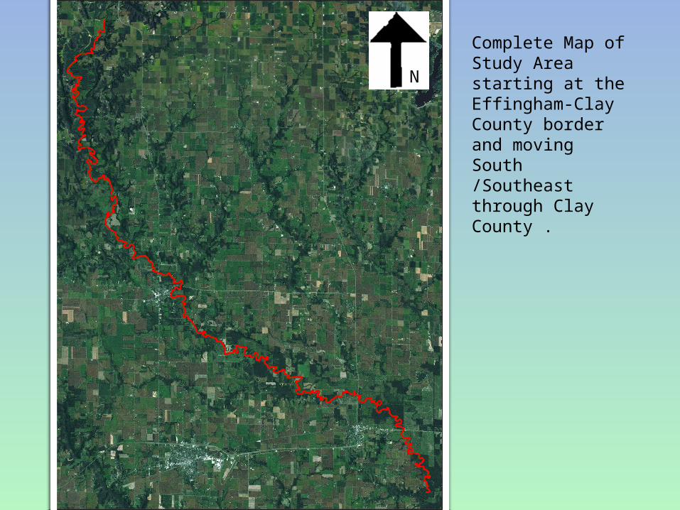
Complete Map of Study Area starting at the Effingham-Clay County border and moving South /Southeast through Clay County .
N
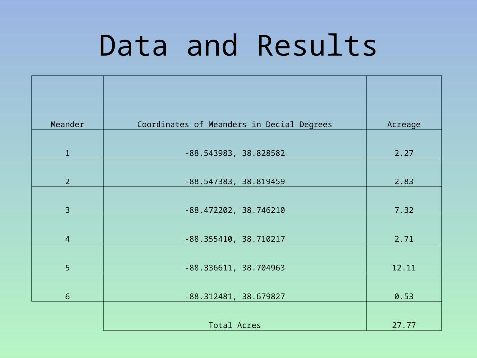
Data and Results
Meander Coordinates of Meanders in Decial Degrees Acreage
1 -88.543983, 38.828582 2.27
2 -88.547383, 38.819459 2.83
3 -88.472202, 38.746210 7.32
4 -88.355410, 38.710217 2.71
5 -88.336611, 38.704963 12.11
6 -88.312481, 38.679827 0.53
Total Acres 27.77
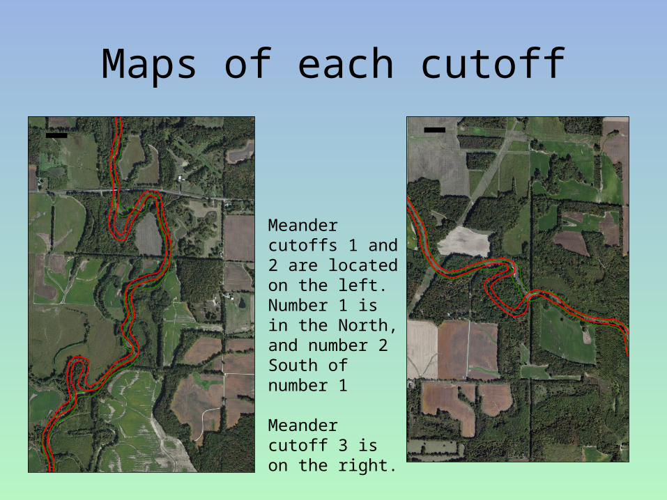
Maps of each cutoff
Meander cutoffs 1 and 2 are located on the left. Number 1 is in the North, and number 2 South of number 1
Meander cutoff 3 is on the right.
¯ ¯
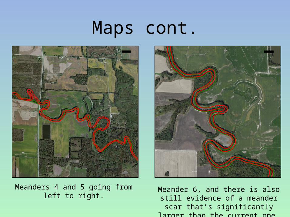
Maps cont.
Meanders 4 and 5 going from left to right.
Meander 6, and there is also still evidence of a meander scar that’s
significantly larger than the current one.
¯ ¯
ConclusionThe purpose of studying the changes of the Little Wabash
River’s channel is to ascertain how the agricultural land has been
impacted. Every cutoff that is created reduces the ability to farm the
land and creates accessibility issues. Data from this study have
shown that there have been many changes to the course of the Little
Wabash River over a 75 year time span. These are modifications to as
little as an acre of land along smaller bends to a substantial cutoff that
has affected over 12 acres.
The Little Wabash’s channel contains multiple meanders, in
which, future cutoffs may be predicted through future GIS analyses in
the area. This is a great way to help farmers receive compensation for
their losses as physical evidence as to what they loss and how much.
Conclusion cont.
In comparing the historical imagery to the current
data, there is a definite change in land use along the river
channel. In the 1938 images of the channel, areas prior to
the meander cutoffs contained cleared land and cropped
fields. Looking at the current imagery the areas that were
once cut are now densely populated by trees and non-
productive as far as farming is concerned. This is likely
due to efforts of channel stabilization in order to prevent
any further loss or gain of land along the channel.