Embed Size (px)
Citation preview

A Fully Automated Approach to Classifying Urban Land Use and
Cover from LiDAR, Multi-spectral Imagery, and Ancillary Data
Jason ParentQian Lei
University of Connecticut

Land cover and land use
Land cover: the physical material on the earth’s surface (e.g. water, grass, asphalt, etc.)
Land use: the use of the land by humans (e.g. reservoir, agriculture, parking lot, etc.)
Fundamental to landscape analyses and urban planning.2

Opportunities and challenges for high resolution data
Increasing availability of airborne light detection and ranging (LiDAR) and aerial imagery offers opportunities to study landscapes in great detail.
Technically challenging to process… require lots of hard drive space. datasets must be divided into small subsets for
processing. conventional algorithms not well suited to
processing large numbers of subsets

Study objectives and justification Develop fully automated algorithm to
classify high resolution (1-meter) land cover / land use which is applicable over large areas. no previously presented algorithm has been
feasible to apply over large areas.
Specifically, we developed python scripts with ArcGIS to… classify 1-meter land cover from LiDAR and
multispectral data. infer land use from object geometry and
spatial context of land cover features.4

Study area
Located in eastern Connecticut in the northeastern U.S.
Semi-random stratified sample of 30 1x1 km tiles.
Stratified by % impervious cover (according to Connecticut’s Changing Landscape land cover data).
5
0 - 3333 - 6666 – 100
% impervious
4800 km2

Data
LiDAR 2010 leaf-off fall
acquisition Small footprint (44
cm) Near-infrared (1064
nm) > 1.5 pts/m2
6
Aerial orthophotos 2012 leaf-off spring
acquisition Blue, green, red,
and NIR 0.3 meter resolution

Land cover classification rules
7
Land cover Primary characteristicsBuilding Height > 2.5m; no ground
returns
Low impervious cover (low IC)
Low NDVI; no returns 2 to 4.5 meters above ground
Deciduous forest Height > 3m; high NDVI
Coniferous forest Height > 3m; very high NDVI
Medium vegetation Height 0.5 to 3m; high NDVI
Water No returns
Riparian wetlands Low reflectance in all bands; adjacent to water
Low vegetation High return intensity
Pixel- and object-based rules using
structural and spectral properties

Land cover classification example
8
Land Cover
deciduous trees
evergreen trees
medium vegetation
grass / low vegetation
water
wetland
building
road / parking lot / barren
deciduousconiferousmed. veg.low veg.waterwetlandbuildinglow IC

Land cover class accuracies
Class User acc. (%)
Prod. acc. (%)
Water 96 85Building 99 97Low vegetation
91 94
Wetland 26 35Low impervious
93 91
Med. vegetation
61 60
Coniferous trees
90 76
Deciduous trees
95 96
93% overall
Kappa = 0.90
n = 3200
User accuracy: probability that a cell label is correct. Producer accuracy: probability that a cell is correctly labelled.

Land use classification rules
10
Building use Primary characteristic
Non-Residential Large parking area; flat roof; large building size
Multi-family residential
Large parking area; narrow building width; similar building shapes
Single family residential
Small parking area; peak roof; small building size Parcel cadastral information not used
because of limited availability.
Object- and parcel-based rules using object shape/size and parcel land
cover composition

Land use preliminary resultsLand Cover
deciduous trees
evergreen trees
medium vegetation
grass / low vegetation
water
wetland
building
road / parking lot / barren
deciduousconiferousmed. veg.low veg.waterwetlandbuildinglow IC
Land Use 18TBG5110_bldg
ParcelCls
Multi-Family Residential
Non-Residential
Single-Family Residential
multi-familynon-resid.single-family

Land use classification assessment
12
small commercial buildings misclassified as single family due to similar structural characteristics
problems caused by mismatch between land cover and parcel data
Qualitative assessment notes…
12
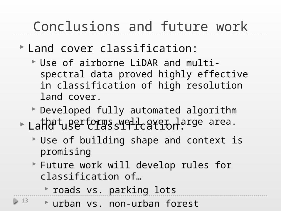
Conclusions and future work Land cover classification:
Use of airborne LiDAR and multi-spectral data proved highly effective in classification of high resolution land cover.
Developed fully automated algorithm that performs well over large area.
13
Land use classification: Use of building shape and context is promising Future work will develop rules for classification
of… roads vs. parking lots urban vs. non-urban forest agriculture vs. turf

A Fully Automated Approach to Classifying Urban Land Use
and Cover from LiDAR, Multi-spectral Imagery, and Ancillary
DataJason Parent
Qian Lei
University of Connecticut
Questions?

![· 2008-08-29 · 1 ䷀ 1. Qian [Pure Yang] (Qian Above Qian Below) Judgment Qian consists of fundamentality [yuan], prevalence [heng], fitness [li], and constancy [zhen]. Commentary](https://img.pdfslide.us/doc/110x75/5f7e394b66d623427a3654aa/2008-08-29-1-1-qian-pure-yang-qian-above-qian-below-judgment-qian-consists.jpg)