Embed Size (px)
Citation preview

A Framework for Integrating A Framework for Integrating Remote Sensing, Soil Remote Sensing, Soil
Sampling, and Models for Sampling, and Models for Monitoring Soil Carbon Monitoring Soil Carbon
SequestrationSequestrationJ. W. Jones, S. Traore, J. Koo,
M. Bostick, M. Doumbia, and J. Naab
SANREM CRSP

• Develop methods that can assist in operationalizing a carbon trading system in West Africa
throughthrough• Land management systems that
increase soil C and meet farmer needs
• System for monitoring soil C changes over time and space
Carbon from Communities:A Satellite View
Goal

Oumarbougou Quickbird image (2003)
Challenges • Complex landscapes
• Interactions among soil, climate, mgt
• Spatial, temporal variability
• Magnitude of soil C needed for trading vs. land area managed by individual landowners

Monitoring Soil C:In-Situ Measurements
Spatial variations in soil C showing measurement points and kriged estimates (Omarbougou, Mali)
Carbon from Communities:A Satellite View
• Collect soil samples from fields– Spatial and temporal
resolution– Errors (sampling,
measuring)– Costs
• Spatial Aggregation Using Geostatistics From R. Yost and M. Doumbia

Monitoring Soil C:Remote Sensing
ResolutionMultispectral - 2.4 m Panchromatic – 0.6
Quickbird Image, Omarabougou, Mali (Oct, 2002)
•Land management identification•Crop identification•Measure field areas•Crop growth, biomass, residue estimation•Sensing landscape changes•Monitor compliance (mgt.)•Errors in each process•Spatial aggregation
•Can not measure soil carbon
Framework for Monitoring Soil Carbon Sequestration

Monitoring Soil C:Modeling
• Predict soil C and crop productivity over time and space
• Soil• Weather• Management
• Field scale • Link with GIS to scale up from field to
community scale • Errors in predictions, imperfect models,
uncertainty in inputs
Carbon from Communities:A Satellite View

DDATAATA
Biomass
Soil C
WeatherManagement
Soil Properties
Parameters
BiomassMeasured
Soil CMeasured
Soil CSimulated
Optimized
BiomassEstimation
Optimized Parameter Estimation
MMODELODEL DDATA ATA AASSIMILATIONSSIMILATION
ENSEMBLE
KALMAN
FILTERBiomassSimulated
Crop/Soil Model
Optimized
Soil CarbonEstimation
Soil Sampling
R/S or Measurements
Integrating Remote Sensing and in-situ Soil C Data with Crop Model using an
Ensemble Kalman Filter
Schematic of data assimilation process for estimation of soil C sequestration using remote sensing and ground observation and a biophysical model (eg. DSSAT-CENTURY).

Measuring Soil C Mass – Field Scale
zsstt dcZ
z))(,0(~ tz ZVarN
zsstt dcZ [ 1 ] w h e r e Z t = M a s s o f s o i l C m e a s u r e d o n d a y t i n a
s p e c i f i c f i e l d , k g [ C ] c t = c o n c e n t r a t i o n o f c a r b o n i n s o i l m e a s u r e d o n d a y t , k g [ C ] k g [ s o i l ] - 1
s = b u l k d e n s i t y o f s o i l , k g [ s o i l ] m - 3
d s = s a m p l i n g d e p t h , m = a r e a o f f i e l d , m 2
z = e r r o r , f i e l d s c a l e s o i l C m e a s u r e , k g [ C ] a n d ))(,0(~ tz ZVarN
Framework for Monitoring Soil Carbon Sequestration

Variance of Soil C Mass, Field Scale
Total Field Soil C Standard Error
0.0
500.01000.0
1500.02000.0
2500.0
3000.03500.0
4000.0
0 0.02 0.04 0.06 0.08 0.1
Soil C Measurement Error, %C
Fie
ld C
Err
or,
kg
Error in soil C measurement
Errors in C measurement, field size, bulk density
)()()()()()()( 222 VardcVardccVardZVar sstssttsst
Framework for Monitoring Soil Carbon Sequestration
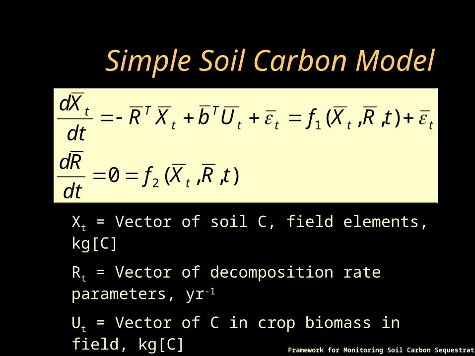
Simple Soil Carbon Model
zsstt dcZ
z))(,0(~ tz ZVarN
zsstt dcZ ),,(0
),,(
2
1
tRXfdt
Rd
tRXfUbXRdt
Xd
t
ttttT
tTt
Xt = Vector of soil C, field elements, kg[C]
Rt = Vector of decomposition rate parameters, yr-1
Ut = Vector of C in crop biomass in field, kg[C]
b = Vector of fractions of biomass not removed
t = time, yrFramework for Monitoring Soil Carbon Sequestration

Measurements, Measurement Errors
tititi Xm ,,,
),0(~ 2mt N
Wheremi,t = measurement in field i, year t (kg[C])Xi,t = Actual soil C in field i, year t (kg[C]) = vector of measurement errors, year t = variance of measurement error
2m
t
Framework for Monitoring Soil Carbon Sequestration

Combining measurements and model predictions using EnKF
)](ˆ[)(ˆ)(ˆ ttttt XmKXX
tX̂ = Vector of estimates of state variables and/or parameters
tm = measurement vector (soil C & remote sensing biomass)
tK = Kalman gain matrix at time t
The (-) and (+) indicate estimates before and after the Kalman update step, respectively

Implementation of EnKF
• Generate ensemble of random samples of soil C, parameters for each field i
• “Measure” biomass, all i fields, year t• Use model to predict soil C at year t+1, each field• Assimilate measurements (soil C, biomass) if
available to update estimates of soil C and its variance/covariance matrix
• Compute aggregate soil C, its variance using the ensemble members
Framework for Monitoring Soil Carbon Sequestration

Ensemble Kalman FilterEstimates of Soil C, Single
Field (Jones et al., 2004)
-1500
-1000
-500
0
500
1000
1500
2000
1 2 3 4 5 6 7 8 9 10 11 12 13 14 15 16 17 18 19 20
Year
Annu
al S
oil C
Cha
nge,
kg/
haMeasured EnKF Estimates True ValuesEstimates of Annual Changes in Soil
C,EnKF, Measurements, and True
Values
Increases in Soil C vs. Years.
Comparing EnKF Estimates with Measurements
Carbon from Communities:A Satellite View

Spatial Example, Wa, Ghana
Figure 4. Twelve fields in Wa, Ghana in which each field was sampled intensely for accurate estimation of soil C via kriging. The fields boundaries are superimposed on a Landsat 7 ETM+ image taken Sept. 9, 2002 (source: J. Naab, SARI, Wa Ghana).
Framework for Monitoring Soil Carbon Sequestration
• DSSAT-Century Crop-Soil Model
• 12 fields, 0.54 ha• 20 samples per field• Krig to estimate initial soil C,
each field• Maize-peanut rotation• Measurements varied (soil C
and biomass)• Estimate aggregate soil C, its
variance

Aggregate Soil C Change per Year
Yearly Carbon Sequestration12 plots (1800 m2) in Nakor, Wa, Ghana
-0.4
-0.3
-0.2
-0.1
0
0.1
0.2
0.3
0.4
2003 2013 2023 2033
(ton
[C]/
regi
on)/
yr
TrueObservedFiltered
Framework for Monitoring Soil Carbon Sequestration
Comparing estimates based on measurements alone (x) vs. those based on the EnKF (red line)

Tradeoff between accuracy and costs
Year 20121: Carbon mesured every year
1/3: Carbon measured every third year
21.5
22.0
22.5
23.0
23.5
2 3 4 5 6 7 8 9 10 11 12 13
No. measured plots / 12 plots
A.
Soi
l C S
td.
Err
or,
(kg)
0
20
40
60
80
100
120
140
B. N
o. soil samples
A. 1A. 1/3B. 1B. 1/3
Framework for Monitoring Soil Carbon Sequestration

150 ha, Near Madiama, Mali
Framework for Monitoring Soil Carbon Sequestration
Example of Contiguous Grazing Area (150 ha)

Uncertainty in Aggregate Soil C Estimate Decreases with Time
2
2.5
3
3.5
4
4.5
5
5.5
6
0 5 10 15 20
year
C e
stim
atio
n er
ror
(%)
# = 25
# = 55
# = 85
Framework for Monitoring Soil Carbon Sequestration
Results from 150 ha grazing land near Madiama, MaliM. Bostick et al.
Requirements for Ensemble Kalman filter Data Assimilation
• Stochastic model of soil C changes vs. time, space, mgt• Parameter estimates for region, knowledge of model errors• Fields in program, mapped, areas determined• Initial soil C & spatial correlation, all fields (sampling,
geostatistics)• Knowledge of measurement errors• Sampling, soil – carbon• Remote sensing measure of crop biomass added each year• EnKF implemented to scale up measurements over space,
time
Framework for Monitoring Soil Carbon Sequestration
Integrating Remote Sensing, Models and in-situ Measurements for Soil Carbon Monitoring

Agricultural management practices can be implemented that– Remove CO2 from the atmosphere
and store it in soil in quantities that would allow land managers to participate in carbon emissions trading
– Reduce land degradation and increase productivity
Hypotheses
Framework for Monitoring Soil Carbon Sequestration

Framework for Monitoring Soil Carbon Sequestration
How Does the Ensemble Kalman Filter Work?

Scaled Up Estimates of Carbon Sequestration
Modeling Predict Carbon Sequestration and Agricultural
Productivity Resulting from Improved Land Use Practices
Improved Land Use Practices
Remote Sensing In Situ Measurements
Remote Sensing
Scale of End User
Individual/Local:Farmers/Herders
Community:Community-Level Natural
Resource Decision-Makers
Sub-National:Researchers, Extensionists,
Commodity Cooperatives
National/Supra-National:National Ministry of Environment,
West African Supra-National Organizations (CILSS/INSAH)
Integrated Framework
Carbon from Communities:A Satellite View