Embed Size (px)
Citation preview


1
Form Based Zoning
Council BriefingDecember 3, 2008

2
PurposePurpose
• Review goals and background of forward Dallas!
• Introduce the new concept of “form-based” zoning
• Review progress made on the new “form-based” zoning districts
• Seek direction on a limited number of outstanding policy issues

3
forwardDallas!forwardDallas!
“Keep in mind always the present you are constructing.
It should be the future you want.”– Alice Walker (author)

4
Dallas in the Global EconomyDallas in the Global Economy

5
forwardDallas! forwardDallas! VisionVision
Fregonese & Associates
$1.3M contract
2 year process
2,200 citizens participated in the development

6
Goal: Broad Public Input• Public Opinion Survey
– October 2004
– 850 respondents
• Interactive Community & Citywide Workshops– 11 workshops from Nov.
2004 through Oct. 2005
– Over 2200 participants
• Open Houses– 9 held in from Feb. 2005
through July 2005

7
forwardDallas!forwardDallas!
•Emphasis on urban design and quality of place
•forwardDallas! Walkable Mixed Use Building Blocks – the precursor of form-based code

8
• Option to live, work, shop and play in the same area and diversity of building scale and density
New Development Patterns

9
• Range of housing choices sensitive to adjacent single family neighborhoods
• Make quality housing more attainable
New Development Patterns

10
• Reduced automobile dependency over time through pedestrian and bicycle friendly streets
New Development Patterns

11
• Public gathering spaces
New Development Patterns

12
forwardDallas! forwardDallas! Building BlocksBuilding Blocks
Urban NeighborhoodsUrban Neighborhoods• Variety of housing types -
single family to townhouses to mid-rise
• Includes jobs, shopping, mixed-use at key intersections
• Transit supportive and walkable with good street connectivity

13
forwardDallas! forwardDallas! Building BlocksBuilding Blocks
Transit CentersTransit Centers• Transit oriented - light rail,
street car, bus rapid transit
• Mixed use - housing, jobs, shopping, recreation, entertainment
• Support walking, biking and reduced parking

14
Land Use Land Use –– Transportation Transportation ConnectionConnection

15
Dallas TrendsVehicle Miles Traveled per Capita1999-2030
3835VMT per Capita
1,404,8471,214,800Population
53,390,10042,987,530Vehicle Miles of Travel (VMT)
2030 Baseline1999 Base YearCharacteristicsNationalAverage VMT per capita
24

16
forwardDallas! ImplementationforwardDallas! Implementation
Priority Implementation Strategy• Develop zoning tools that facilitate new
urban growth approach
– $300,000 contract with Code Studio
– Code amendment process initiated in April 2007

17
Public ProcessPublic Process•Council Quality of Life Committee
appointed Advisory Committee:–26 members chaired by Hector Garcia
–15 meetings
–2 town hall meetings
–Regular postings on forwardDallas!website

18
Public ProcessPublic Process
•City Plan Commission review–3 Ad Hoc Committee meetings
–5 CPC workshops/hearings
–Drafts and minutes posted on website

19
Public ProcessPublic Process
•Council Review–Transportation Committee and Trinity
Committee briefings in May
–Council Study Group led by C.M. Natinsky
–6 formal & informal meetings from July through September

20
Transforming the Built EnvironmentTransforming the Built EnvironmentConventional Zoning Form-Based Zoning
Zoning Ordinance makes this easy
Zoning Ordinance makes this difficult
Sam’s Club on Park Lane West Village

21
Lack of ClarityLack of Clarity
•Conventional Zoning •Form-Based Zoning
Regulations Hard to Understand
Regulations Clear and Understandable

22
Focus on Form or UseFocus on Form or Use
Used Car Dealership

23
Focus on Form or Use?
Both structures are defined as single family uses in a Residential Zoning district.

24
Form verses UseForm verses Use
Library

25
Form verses UseForm verses Use
Church

26
Form More Important than UseForm More Important than Use
UrbanAdvantageUrbanAdvantage

27
Dallas Form DistrictsDallas Form DistrictsEnabling Ordinance OnlyEnabling Ordinance Only
•Establishes new zoning districts
•Doesn’t change existing zoning map
•Public hearing process is required to approve new form districts in particular locations

28
Dallas Form DistrictsDallas Form DistrictsFlexible Tool KitFlexible Tool Kit
•3 New Base Districts:– Walkable Mixed Use
– Walkable Residential
– Residential Transition
•3 New Overlay Districts:– Shopfront Overlay
– Height Map Overlay
– Parking Management Overlay

29
Dallas Form DistrictsDallas Form DistrictsNew Parking ApproachNew Parking Approach
• Adopts modified ULI parking standards
• Parking reductions:– Transit proximity
– Affordable housing
– Ride-share, carpool, telecommuting
– No reduction in Residential Transition Districts
• On-street parking counts
• Adopts ULI shared parking model
• Flexibility through parking management

30
Key Policy IssuesKey Policy Issues• Council Development Priorities
– Do the new districts serve the Council’s goals?
• Council Authority in Zoning Cases– Do the new districts retain Council authority?
• Zoning Flexibility and Transparency– Are the new districts useful, efficient tools for small
developers as well as more affluent?

31
Items of discussionDrive-through facilities
Residential ground floor heightRegulating plans Parking considerationsResidential Neighborhood district
Open Space
Transitional uses
Height regulationsCritical Mass and Parking Reductions

32
a) Include intent statementb) Omit min. size requirement and include graduated parking reductions
a)Omit minimum size requirement b)Include critical mass statement of intent
a)Impose minimum size requirement b)Impose critical mass locational criteria
40/25 Acre Minimum Critical Mass Test
9
RPS is default. CPC and CC have discretion to amend with height map
Height map can serve as alternative to RPS
Mandatory Residential Proximity Slope. CC cannot waive.
Method To Control Height Near Single Family Residential
8
Deviation from Form-based regulations by SUP for 5 year renewable by Council
a)Omit Transitional Usesb)Omit Board of Adjustment waiver provision
a)Allow by SUP b)Allow Board of Adjustment to waive any/all regulations
Transitional UsesIn WMU and WR
7
Revised open spacerequirement of 8% with allowable credits
Omit landscape median optionAllow landscape median to satisfy open space requirement
Open Space Requirement
6
a)Allow RTN as buffer to adjacent single family uses/districtsb)Allow as stand-alone district
a)Impose 100’ or ½ block minimum (whichever less)b)Do not allow as stand-alone district
a)Mandatory RTN district minimum ½ block b)Do not allow as stand-alone district
Residential TransitionDistrict
5
Allow 2% reduction between ¼mile and ½ mile of DART Station
Expand reductions up to ½mile of DART Station
Allow reductions within ¼mile of DART Station
Transit Parking Reductions
4
Require definite zoning boundaries
Require definite zoning boundaries
Allow general location of proposed boundaries
Regulating Plan3
Recommend, but do not requireImpose 30” raised minimumNo requirementResidential Ground Floor Minimum
2
Allow by SUPAllow by right inside parking garage
Omit drive-thru usesAllow by SUPDrive Thru Facilities1
Council Study Group Recommendation
Consultant/staff Recommendation
CPC RecommendationIssue#

33
Issue # 1 Drive-thru facilities• Are drive through facilities compatible with
the goals of form districts?
• Is there a need to allow drive through facilities in form districts?

34
Downtown Drive Through

35
Issue # 2 Floor Height• Should raised height for ground story
residential uses be required or just encouraged?
• Raised ground floor enhances street character and sense of privacy in homes along street frontages

36
Residential Ground Floor Height
30 inch floor height

37
Residential Ground Floor Height

38
Issue # 3 Regulating Plans• Should zoning change be approved with
only general location of overlay districts?
• This would be similar to:– approving an SUP without establishing specific
boundaries
– Approving a PD with only general location of sub-districts

39
Issue # 4 Parking
Should a modest parking reduction be available for projects within ½ mile of transit?
Should developers be allowed to charge for parking?
Should compact parking continue to be allowed or should it be eliminated?

40
Compact SpacesAre the results working?

41
Issue # 5 Imposed RTN
Should this Residential District have a mandatory placement requirement?
Should City Council have discretion to require or not require based on the individual case?

42
Coit DART Station AreaHypothetical Development Proposal

43
Imposed RTN district

44
Lake Highlands Town Center

45
Lake Highlands Town CenterConceptual Elevations

46
Issue # 6 Open SpaceHow much open space should be required?
What size developments should provide open space?
Should open space be public or privately owned and maintained?
How should open space be provided?

47
Issue # 6 Open SpaceCurrent draft requires • Developments of 25 acres +• Open Space Overlay imposed• Provision of 4% of net area as open space• Reduction can be made if development is
within proximity of existing (public) open space
• Allows landscaped median to meet requirement

48
Open SpaceState Thomas

49
Open SpaceWest Village

50
Young StreetLandscaped Median

51
Issue # 7 Transitional Uses
All permitted uses +• Crop production• Building repair and maintenance• Catering, large scale• Tool and equipment rental• Lumber, brick or building materials sales
yard• Recycling collection center• Country club with private membership• Private recreation center• Public golf course• Commercial amusement outside

52
Policy ConcernsAny of the listed uses can be approved
as transitional uses by SUPBoard of Adjustment can approve
special provision that exempts transitional uses from all form-based requirements and regulations.
Unprecedented provision that allows Board of Adjustment to “unzone”Council approved zoning requirements.

53
Issue # 8 How can height be most effectively regulated and easily understood?
•By imposing the existing Residential Proximity Slope in all instances?
•By using Height Maps to allow more clarity?
•By allowing either RPS or Height Maps or both as a tool to provide neighborhoods with the most control and protection?

54
What are Height Maps?
Graphic representation on the zoning map
Provides precise control of height with simple, clear regulation
Allows site specific negotiation to dictate acceptable height with input from adjacent property owners and neighborhood leaders

55
Walkable Residential District (WR-5)
Height Map
Height Map Overlay
R-7.5(A)
5 stories
2 stories
Land Parcels

56
Residential Proximity Slope

57
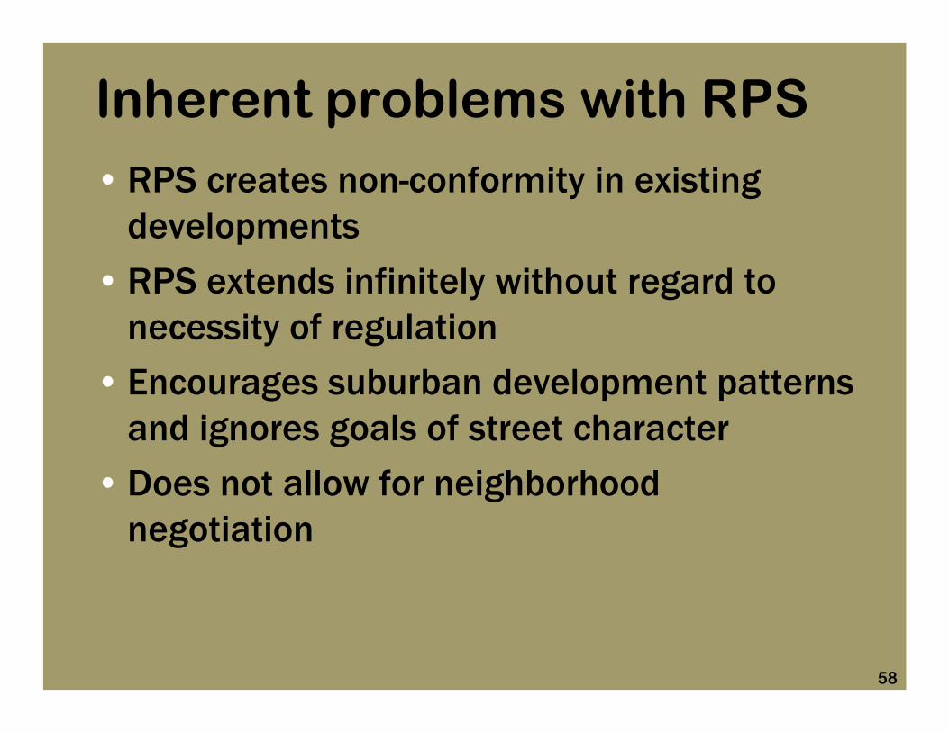
Inherent problems with RPS• RPS lacks transparency and clarity
• RPS doesn’t address site specific issues or adjacency, bureaucratic formula controls
• A complicated mathematic equation creates confusion.
• RPS assumes the world is flat
• RPS is triggered by non-residential uses in residential districts
58
Inherent problems with RPS• RPS creates non-conformity in existing
developments
• RPS extends infinitely without regard to necessity of regulation
• Encourages suburban development patterns and ignores goals of street character
• Does not allow for neighborhood negotiation

59
RPS lacks clarity• Mathematical equation with complicated set of
rules determines allowable height at any particular place on site. – Must know adjacent zoning
– Must know site of origination
– Must know default height
– Must know where to measure
– Must know rise over run calculation
– Must know exemptions
• Unable to determine height by referring to the zoning map

60
RPS assumes a flat earth

61
RPS encourages development to impose additional burdens

62
ExistingSynagogue
ProposedShopping
Center
R-7.5(A)CR
RPS is triggered by non-residential uses in residential districts

63
ExistingSynagogue
ProposedShopping
Center
RPS is triggered by non-residential uses in residential districts
60 feet
HilcrestRoad
R-7.5 (A)CR
26 feet

64
RPS is triggered by districts, not uses
MF-2TH-2
36 feet26 feet
Townhomes in TH Zoning
Townhomes in MF Zoning

65
RPS can create non-conformity on adjacent properties
CRMF-2
Existing Apartments in Multifamily Zoning
Vacant Lot in CR Zoning
TH-2
Rezoned to TH for new townhomes
Existing third floor becomes con-
conforming

66
RPS extends to infinity
THCRMF
• Third story multifamily not permitted behind retail frontage

67
RPS encourages development to set back from the street
THForm District
• Conflicts with street character goals of form districts

68
Residential Proximity Slope• CPC draft requires the RPS in all situations• Retains height restrictions prior to new zoning• Eliminates Council authority to negotiate a
more compatible solution to site specific and neighborhood concerns.
• Mandated height provisions results in redundant, complicated and inflexible regulations.

69
Height - Policy Question
•Should control of height be complicated by a bureaucratic formula that people find difficult to understand?
•Should prior height regulations bind Council decisions in future zoning cases?

70
Issue # 9 Critical MassWhere can new districts be used?
defined as -
– 40 acres of existing high-density multi-family or multiple-use development or PD zoning; or
– 25 acres within an adopted area plan; or
– 25 acres that will be dense residential, commercial and other uses

71
A Tool for City Council to bring about needed change?
Priority redevelopment areas
• Redevelopment of aging deteriorated multi-family properties
• Mixed-use developments around DART stations
• Conversion of obsolete industrial land• Trinity River Corridor

72
Council Priority Areas • Trinity Corridor
• DART Station Areas

73
Industrial Zoning

74
Dense Multifamily Zoning
MFTH

75
Dense Multifamily & Mixed Use
Zoning
MFTH
MU

76
Dense Multi-family Zoned Land
• Will not allow TOD near DART light rail stations or Trinity Corridor
• May encourage redevelopment of aging and deteriorated multi-family complexes
• May encourage transition and speculation in stable single family neighborhood

77
Does CPC Critical Mass Provision Does CPC Critical Mass Provision Protect Stable Neighborhoods?Protect Stable Neighborhoods?
Gre
envi
lle
Prospect
MF-2(A)
R-7.5(A)
235 Acres
East Dallas
Coc
krel
l Hill
MF-2(A)
R-7.5(A)
Meredith
68 Acres
Oak Cliff

78
How Big is 40 Acres?
• Cityville @ Medical District: 5.7 acres
• West Village Phase I: 6.5 acres
• Mockingbird Station: 8.7 acres
• ICON Development: 19.0 acres
• JPI Development: 55.0 acres

79
Mockingbird Station Area
E. Mockingbird Ln.
Greenville A
ve.
20 acres
• Mockingbird Station Development - 8.7 acre site
• Adjacent DART parking lot -

80
ICON Midtown Dallas Site
Dallas N
orth Tollway
I-635
Preston R
d.
19 acres

81
JPI Development (PD 774)
Woo
dall R
ogers
Fwy.
Interstate 35
Continental Viaduct
Commerce StIndustrial Blvd.
55 acres

82
West Dallas along Singleton
rail line
Singleton Blvd.
Bata
an S
t.
Sylvan A
ve.
42 acres
Can “critical mass” be achieved?42 acres covers 79 parcelsExisting industrial zoning

83
Corinth Street DART StationTransit-Oriented Development
• 38 acres with 62 parcels
• Adjacent zoning is industrial and townhouse
• Form districts could not be used for re-development
38 acres
DART station

84
Illinois Street DART Station Area Monroe Shops (under 18 Acres)
E. Illinois Ave.S.
Cor
inth
• TOD station planning
• 18 acres• Adjacent zoning is
Single Family• Form districts
could not be used for re-development

85
Asian Trade DistrictHarry Hines & Royal Lane
Harry H
ines Blvd.Royal Ln.
40 acres
• 8 property owners in a 40 acre area
• Area is ripe for transition
• Nearest residential neighborhood is over 1/2 mile away
• Currently zoned industrial
DARTStation

86
Policy Questions
• Should there be a constraint imposed on City Council’s use of this new tool?
• Should Council have the ability to consider new districts for areas smaller than 40 acres to begin process of incremental change and redevelopment?• Should these new zoning tools be available for walkable mixed-use development by small developers?

87
Council Study GroupCouncil Study GroupForm Districts Purpose StatementForm Districts Purpose Statement
• Encourage walkable mixed use development in the Southern Sector, Trinity River Corridor, DART transit station areas, and deteriorated multifamily or commercial areas throughout the City
• Not appropriate where council determines that height, density, parking reductions could adversely impact nearby, stable single family neighborhoods

88
Council Study GroupCouncil Study GroupModified Parking ReductionsModified Parking Reductions• Maximum parking reductions depend on site area
to address concerns about parking spill over
50%Over 40 Acres
40%15 to 40 Acres
30%10 to 15 Acres
20%5 to 10 Acres
10%0 to 5 Acres
Max. Parking ReductionSite Area

89
Do Critical Mass Provisions Further With Council Priorities?
• Should walkable development be encouraged only in areas where critical mass already exists?
• Should form districts not be used to introduce change for small-scale developments?

90
Why are Form Districts Important?Why are Form Districts Important?
• Building our Economy and Tax Base
• Quality of place attracts the “creative class”
• Jobs follow talented, educated work force
• Jobs of the future have not yet been invented

91
Competing in a Global EconomyCompeting in a Global Economy
• Most businesses are footloose
• Compete with New York, Chicago, London, Tokyo, Vancouver

92
Form Based Districts
Next Steps
Council may:• Take action today, or
• Defer to committee for further discussion and refinement, or
• Consider ordinance on December 10th
Public Hearing