Embed Size (px)
Citation preview

V-1
V C h a p t e r V
AFFECTED ENVIRONMENT AND ENVIRONMENTAL CONSEQUENCES
INTRODUCTION This chapter presents a description of the environment and how it may be affected by the No Action, San Juan River Public Service Company of New Mexico (SJRPNM), and Navajo Indian Irrigation Project (NIIP) Amarillo Alternatives. These alternatives are described in chapter IV. This chapter is organized by resource topic. Under each resource is an overview, a discussion of the affected environment, the methodology used to determine impacts, an impacts analysis, and potential mitigation measures. Each resource topic concludes with a summary of impacts. The impacts analysis presents short-term, long-term, direct, indirect, and cumulative effects on resources and, when applicable, potential mitigation measures. It assumes that related projects described in chapter I—the NIIP, San Juan River Basin Recovery Implementation Program (SJRBRIP), Animas-La Plata (ALP) Project, and Navajo Reservoir Operations—are fully implemented. There would, however, be an interim period, possibly decades, before full development of these projects, and during this time additional San Juan River water would be available to meet other purposes, as discussed in the Navajo Reservoir Operations Final Environmental Impact Statement (FEIS) (Bureau of Reclamation [Reclamation], 2006). In this chapter, the resources described are those potentially affected by or central to changes related to the Navajo-Gallup Water Supply Project (proposed project) and include water uses and water resources, Indian Trust Assets (ITAs), water quality, vegetation, wildlife and aquatic resources, special status species, recreation, land use, hazardous material sites, soils and geology, paleontology, air quality, socioeconomics, environmental justice, land use, and cultural resources. Potential measures to mitigate adverse impacts of the proposed project are presented in this chapter, and environmental commitments are described in chapter VI.
Introduction Setting Navajo Reservoir Operations Affected Resources Other Impacts Considerations Conclusions and Summary of Impacts
Navajo-Gallup Water Supply Project
V-2
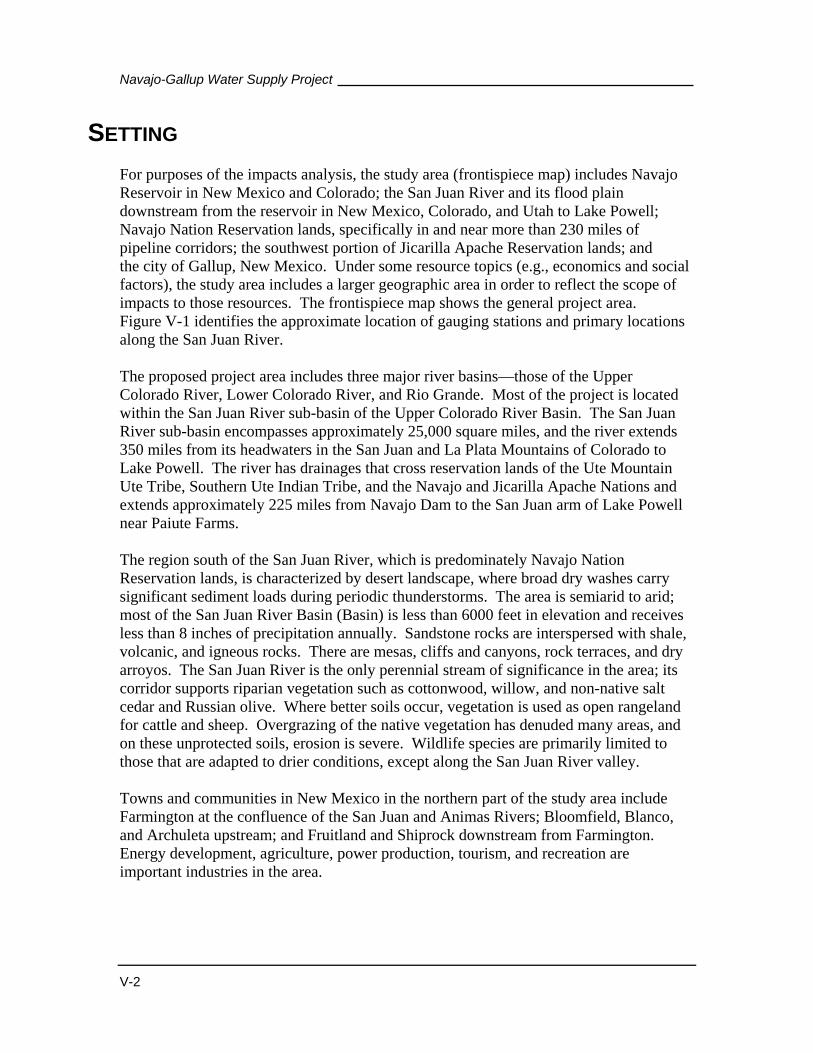
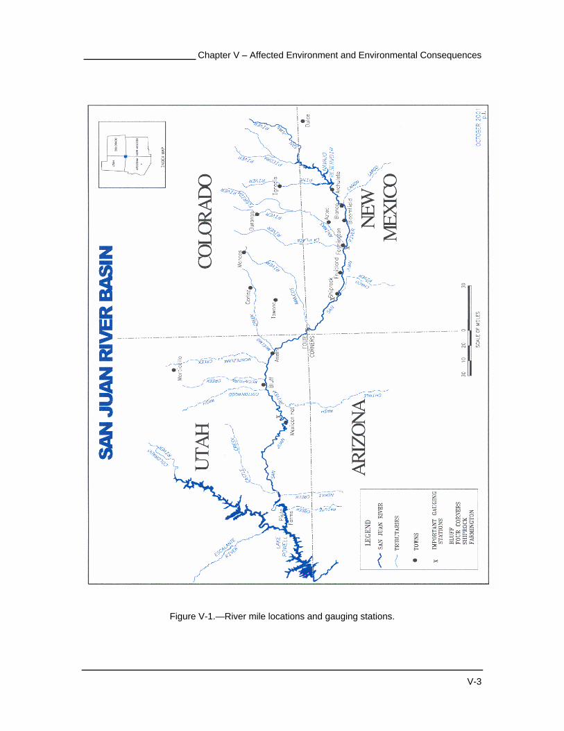
SETTING For purposes of the impacts analysis, the study area (frontispiece map) includes Navajo Reservoir in New Mexico and Colorado; the San Juan River and its flood plain downstream from the reservoir in New Mexico, Colorado, and Utah to Lake Powell; Navajo Nation Reservation lands, specifically in and near more than 230 miles of pipeline corridors; the southwest portion of Jicarilla Apache Reservation lands; and the city of Gallup, New Mexico. Under some resource topics (e.g., economics and social factors), the study area includes a larger geographic area in order to reflect the scope of impacts to those resources. The frontispiece map shows the general project area. Figure V-1 identifies the approximate location of gauging stations and primary locations along the San Juan River. The proposed project area includes three major river basins—those of the Upper Colorado River, Lower Colorado River, and Rio Grande. Most of the project is located within the San Juan River sub-basin of the Upper Colorado River Basin. The San Juan River sub-basin encompasses approximately 25,000 square miles, and the river extends 350 miles from its headwaters in the San Juan and La Plata Mountains of Colorado to Lake Powell. The river has drainages that cross reservation lands of the Ute Mountain Ute Tribe, Southern Ute Indian Tribe, and the Navajo and Jicarilla Apache Nations and extends approximately 225 miles from Navajo Dam to the San Juan arm of Lake Powell near Paiute Farms. The region south of the San Juan River, which is predominately Navajo Nation Reservation lands, is characterized by desert landscape, where broad dry washes carry significant sediment loads during periodic thunderstorms. The area is semiarid to arid; most of the San Juan River Basin (Basin) is less than 6000 feet in elevation and receives less than 8 inches of precipitation annually. Sandstone rocks are interspersed with shale, volcanic, and igneous rocks. There are mesas, cliffs and canyons, rock terraces, and dry arroyos. The San Juan River is the only perennial stream of significance in the area; its corridor supports riparian vegetation such as cottonwood, willow, and non-native salt cedar and Russian olive. Where better soils occur, vegetation is used as open rangeland for cattle and sheep. Overgrazing of the native vegetation has denuded many areas, and on these unprotected soils, erosion is severe. Wildlife species are primarily limited to those that are adapted to drier conditions, except along the San Juan River valley. Towns and communities in New Mexico in the northern part of the study area include Farmington at the confluence of the San Juan and Animas Rivers; Bloomfield, Blanco, and Archuleta upstream; and Fruitland and Shiprock downstream from Farmington. Energy development, agriculture, power production, tourism, and recreation are important industries in the area.
Chapter V – Affected Environment and Environmental Consequences
V-3
Figure V-1.—River mile locations and gauging stations.

Navajo-Gallup Water Supply Project
V-4
In the southern part of the proposed project area, the city of Gallup, although located off-reservation, has a significant and growing population (estimated currently at 36 percent) of Native American residents. As noted in chapter I, the city serves as an economic center for the surrounding area. To the east, the community of Crownpoint is the site of the Eastern Navajo Agency of the Bureau of Indian Affairs (BIA). To the west, Window Rock is the capital and center of government of the Navajo Nation, and nearby Fort Defiance also houses government functions and a large regional hospital. More than 20 smaller communities are located along Route 491 between the city of Gallup and Shiprock. These areas around the city of Gallup are drained by a stream—the Rio Puerco of the West (Lower Colorado River Basin). The Rio Puerco of the West is the largest drainage in the area, originating east of the city of Gallup and flowing southwest into Arizona. Flow in the Rio Puerco of the West is intermittent, usually associated with thunderstorms and spring snowmelt, and is short-lived. Navajo Nation lands in the southeastern portion of the proposed project area are within the Rio Grande Basin. These include the Huerfano, Nageezi, Counselor, Pueblo Pintado, Whitehorse Lake, Ojo Encino, and Torreon Chapters of the Navajo Nation.
NAVAJO RESERVOIR OPERATIONS Reclamation, in April 2006, completed the Navajo Reservoir Operations FEIS, and the Navajo Reservoir FEIS Record of Decision (ROD) was signed in July 2006. In accordance with the ROD, the reservoir will be operated in the future so that releases from Navajo Dam will generally range between 250 to 5,000 cubic feet per second (cfs) (the FEIS 250/5000 Alternative). For further details on this and other related projects, see the “Cumulative Impacts, Operation of Navajo Dam” section).
AFFECTED RESOURCES To identify affected resources, issues were derived by using the scoping process, review of agency and public comments, and meeting with cooperating agencies.1 Significant issues are discussed for each resource.
1 Cooperating agencies for preparation of the environmental impact statement portion of this document include the Navajo and Jicarilla Apache Nations, State of New Mexico, Northwest New Mexico Council of Governments, city of Gallup, Navajo Tribal Utility Authority, BIA, and Indian Health Service.
Chapter V – Affected Environment and Environmental Consequences
V-5
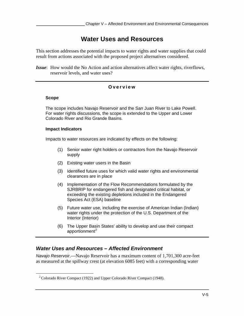
Water Uses and Resources This section addresses the potential impacts to water rights and water supplies that could result from actions associated with the proposed project alternatives considered. Issue: How would the No Action and action alternatives affect water rights, riverflows,
reservoir levels, and water uses?
O v e r v i e w
Scope
The scope includes Navajo Reservoir and the San Juan River to Lake Powell. For water rights discussions, the scope is extended to the Upper and Lower Colorado River and Rio Grande Basins.
Impact Indicators Impacts to water resources are indicated by effects on the following:
(1) Senior water right holders or contractors from the Navajo Reservoir
supply
(2) Existing water users in the Basin
(3) Identified future uses for which valid water rights and environmental clearances are in place
(4) Implementation of the Flow Recommendations formulated by the SJRBRIP for endangered fish and designated critical habitat, or exceeding the existing depletions included in the Endangered Species Act (ESA) baseline
(5) Future water use, including the exercise of American Indian (Indian) water rights under the protection of the U.S. Department of the Interior (Interior)
(6) The Upper Basin States’ ability to develop and use their compact apportionment2
Water Uses and Resources – Affected Environment Navajo Reservoir.—Navajo Reservoir has a maximum content of 1,701,300 acre-feet as measured at the spillway crest (at elevation 6085 feet) with a corresponding water
2 Colorado River Compact (1922) and Upper Colorado River Compact (1948).

Navajo-Gallup Water Supply Project
V-6
surface area of 15,610 acres. The inactive content, defined as the storage below the NIIP inlet works, is 625,675 acre-feet with a corresponding water surface elevation of 5985 feet. During the irrigation season, the minimum operating level for the NIIP diversion intake is at elevation 5990 feet, or 661,800 acre-feet of storage; however, the reservoir can be drawn down during the winter to elevation 5985 feet, or 625,675 acre-feet of storage, as long as the reservoir recovers sufficiently prior to the NIIP irrigation season. San Juan River.—The San Juan River below Navajo Dam is the largest river in the Basin and collects inflow from perennial tributaries—the Animas, La Plata, and Mancos Rivers—and other intermittent tributaries. At its confluence with Lake Powell, the San Juan River produces a long-term average natural flow3 of about 2.0 million acre-feet4 (MAF). The San Juan River above the Animas River confluence contributes about one-half of this amount. Mean annual runoff to the San Juan River at Farmington just downstream of the confluence with the Animas River is about 1.3 MAF under present depletion conditions. Near Bluff, Utah, mean annual runoff increases to about 1.4 MAF under present conditions. The increase is accounted for by tributary or side inflow downstream of Farmington. As with the other rivers, flows peak in the spring and remain low from summer to fall, punctuated by short-duration peaks resulting from storm events. The river is partially regulated by Navajo Dam, and its tributaries are substantially used for irrigation. Navajo Dam has tended to reduce peak spring flows and to supplement flows in other seasons since its operation began in 1962. Implementation of Flow Recommendations, as described in the Navajo Reservoir Operations FEIS, would result in a more “natural” hydrograph with higher spring flows and lower base flows, as depicted in figure V-2 (Holden, 1999; Reclamation, 2006). Water Rights Background.—See chapter I, “Water Rights Background,” for information about Indian water rights, the Colorado River compacts, and the La-Plata River and Animas-La Plata compacts. New Mexico – New Mexico Water Law – New Mexico water law is based on the prior appropriation doctrine. Basically, the first user (appropriator) in time has the priority
3 Natural flows are flows that would exist in the San Juan River, excluding any manmade uses of the flows. 4 Natural flow data for the period 1929–93 developed for the SJRBRIP.

Chapter V – Affected Environment and Environmental Consequences
V-7
Figure V-2.—Hydrograph of San Juan River at Shiprock.
to take and use water. The State Engineer has the primary responsibility for supervision, measurement, appropriation, administration, and recordkeeping. The State courts have primary responsibility with respect to quantifying water rights when there is a general stream adjudication. Navajo Nation and Jicarilla Apache Nation Uses – For much of its path from Navajo Dam to Lake Powell, the San Juan River either flows through or forms the northern boundary of the Navajo Nation. The Basin has not been fully adjudicated. Not all Navajo Nation reserved water rights in the Basin have been quantified. However, the San Juan River Basin in New Mexico Navajo Nation Water Rights Settlement Agreement (Navajo Settlement Agreement), once executed by the Secretary of the Interior (Secretary), will settle the Nation’s water right claims in the Basin in New Mexico. The proposed project is a cornerstone piece of the Navajo Settlement Agreement. The Congress, as part of Public Law (P.L.) 111-11 (see attachment P), approved the Navajo Settlement Agreement and authorized the proposed project. Under P.L. 111-11, the Secretary shall execute an agreement consistent with the provisions of the act by December 31, 2010. Potential impacts of alternatives on Navajo Nation water rights are discussed in the “Indian Trust Assets” section of this chapter. The Jicarilla Apache Nation’s water rights in the Basin are under the 1992 Jicarilla Apache Tribe Water Rights Settlement Act (Jicarilla Settlement Act) and a 1999 Partial
Navajo-Gallup Water Supply Project
V-8
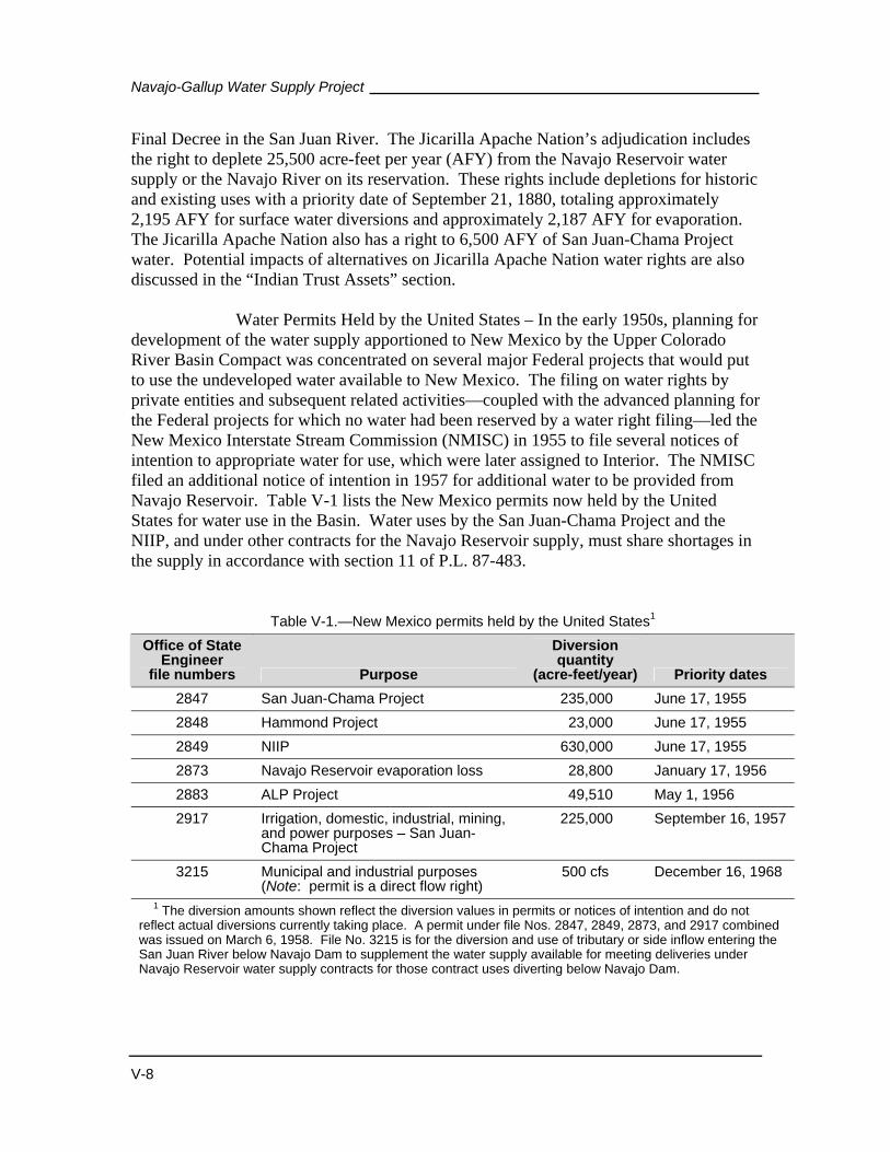
Final Decree in the San Juan River. The Jicarilla Apache Nation’s adjudication includes the right to deplete 25,500 acre-feet per year (AFY) from the Navajo Reservoir water supply or the Navajo River on its reservation. These rights include depletions for historic and existing uses with a priority date of September 21, 1880, totaling approximately 2,195 AFY for surface water diversions and approximately 2,187 AFY for evaporation. The Jicarilla Apache Nation also has a right to 6,500 AFY of San Juan-Chama Project water. Potential impacts of alternatives on Jicarilla Apache Nation water rights are also discussed in the “Indian Trust Assets” section. Water Permits Held by the United States – In the early 1950s, planning for development of the water supply apportioned to New Mexico by the Upper Colorado River Basin Compact was concentrated on several major Federal projects that would put to use the undeveloped water available to New Mexico. The filing on water rights by private entities and subsequent related activities—coupled with the advanced planning for the Federal projects for which no water had been reserved by a water right filing—led the New Mexico Interstate Stream Commission (NMISC) in 1955 to file several notices of intention to appropriate water for use, which were later assigned to Interior. The NMISC filed an additional notice of intention in 1957 for additional water to be provided from Navajo Reservoir. Table V-1 lists the New Mexico permits now held by the United States for water use in the Basin. Water uses by the San Juan-Chama Project and the NIIP, and under other contracts for the Navajo Reservoir supply, must share shortages in the supply in accordance with section 11 of P.L. 87-483.
Table V-1.—New Mexico permits held by the United States1 Office of State
Engineer file numbers Purpose
Diversion quantity
(acre-feet/year) Priority dates
2847 San Juan-Chama Project 235,000 June 17, 1955 2848 Hammond Project 23,000 June 17, 1955 2849 NIIP 630,000 June 17, 1955 2873 Navajo Reservoir evaporation loss 28,800 January 17, 1956 2883 ALP Project 49,510 May 1, 1956 2917 Irrigation, domestic, industrial, mining,
and power purposes – San Juan-Chama Project
225,000 September 16, 1957
3215 Municipal and industrial purposes (Note: permit is a direct flow right)
500 cfs December 16, 1968
1 The diversion amounts shown reflect the diversion values in permits or notices of intention and do not reflect actual diversions currently taking place. A permit under file Nos. 2847, 2849, 2873, and 2917 combined was issued on March 6, 1958. File No. 3215 is for the diversion and use of tributary or side inflow entering the San Juan River below Navajo Dam to supplement the water supply available for meeting deliveries under Navajo Reservoir water supply contracts for those contract uses diverting below Navajo Dam.
Chapter V – Affected Environment and Environmental Consequences
V-9
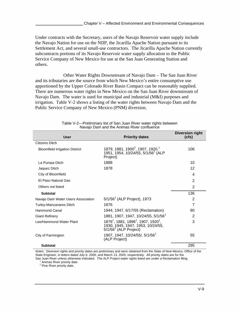
Under contracts with the Secretary, users of the Navajo Reservoir water supply include the Navajo Nation for use on the NIIP, the Jicarilla Apache Nation pursuant to its Settlement Act, and several small-use contractors. The Jicarilla Apache Nation currently subcontracts portions of its Navajo Reservoir water supply allocation to the Public Service Company of New Mexico for use at the San Juan Generating Station and others. Other Water Rights Downstream of Navajo Dam – The San Juan River and its tributaries are the source from which New Mexico’s entire consumptive use apportioned by the Upper Colorado River Basin Compact can be reasonably supplied. There are numerous water rights in New Mexico on the San Juan River downstream of Navajo Dam. The water is used for municipal and industrial (M&I) purposes and irrigation. Table V-2 shows a listing of the water rights between Navajo Dam and the Public Service Company of New Mexico (PNM) diversion.
Table V-2—Preliminary list of San Juan River water rights between Navajo Dam and the Animas River confluence
User Priority dates Diversion right
(cfs)
Citizens Ditch Bloomfield Irrigation District 1879, 1881, 19002, 1907, 1920,1
1951, 1954, 10/24/55, 5/1/561 (ALP Project)
106
La Pumpa Ditch 1888 10 Jaquez Ditch 1878 12 City of Bloomfield 4 El Paso Natural Gas 2 Others not listed 2 Subtotal 136 Navajo Dam Water Users Association 5/1/561 (ALP Project), 1973 2 Turley-Manzanares Ditch 1876 7 Hammond Canal 1944, 1947, 6/17/55 (Reclamation) 90 Giant Refinery 1881, 1907, 1947, 10/24/55, 5/1/561 2 Lee/Hammond Water Plant 18761, 1881, 18961, 1907, 19201,
1930, 1945, 1947, 1953, 10/24/55, 5/1/561 (ALP Project)
3
City of Farmington 1907, 1947, 10/24/55/, 5/1/561 (ALP Project)
55
Subtotal 295 Notes: Diversion rights and priority dates are preliminary and were obtained from the State of New Mexico, Office of the State Engineer, in letters dated July 6, 2000, and March 13, 2003, respectively. All priority dates are for the San Juan River unless otherwise indicated. The ALP Project water rights listed are under a Reclamation filing. 1 Animas River priority date. 2 Pine River priority date.

Navajo-Gallup Water Supply Project
V-10
Colorado – Colorado water law is based on the prior appropriation doctrine, which states that the first appropriator in time has the first priority to take and apply water to beneficial use without waste. The right to divert the unappropriated waters of natural streams to beneficial uses is never to be denied under Colorado’s constitution; the Colorado water courts grant decrees to use water and set priorities. The Colorado State Engineer and the Division of Water Resources administer the water rights according to the priorities, measure flows, and record the use of water. Use of Colorado’s compact apportionment can be supplied from many river sources, including the San Juan River. Numerous water rights exist in Colorado on the San Juan River upstream of Navajo Dam and on tributaries to the San Juan River. Arizona – As stated above, the San Juan River either flows through or forms the northern boundary of the Navajo Nation. The main stem of the San Juan River does not flow through Arizona; however, all tributaries in Arizona to the San Juan River are on Navajo Nation lands. Water rights for the Navajo Nation on the tributaries in Arizona have not been quantified. The Navajo Nation claims sufficient water from these tributaries necessary to create a permanent homeland for the Navajo people. Arizona is limited to an annual consumptive use of 50,000 acre-feet of water from the Upper Basin (depletion in flows at Lee Ferry) pursuant to its apportionment under the Upper Colorado River Basin Compact. In 2000, the total consumptive use of water in the Upper Basin in Arizona was about 38,100 AFY according to Reclamation’s Consumptive Use and Loss Report 1996–2000. Utah – In Utah, water law is also based on the prior appropriation doctrine, and water use is managed in a manner similar to that of the State of Colorado. In Utah, the San Juan River forms the northern boundary of Navajo Nation Reservation lands. The same principle applies here with respect to the Navajo Nation claims for sufficient water to provide a permanent homeland for its people. A number of non-Indian water rights exist on the north side of the San Juan River and on tributaries that drain into the San Juan River from the north. While the Colorado River Compact makes provisions for flows to be delivered from the Upper Basin to the Lower Basin at Lee Ferry, it does not require that specific amounts of water be contributed to Lee Ferry from the San Juan River or from any other particular Upper Basin tributary. The Glen Canyon National Recreation Area may have an unquantified Federal reserved water right on the San Juan arm of Lake Powell. This right would be junior to that for Navajo Reservoir, and the Navajo Unit has no obligation to bypass water for this right.5 Table V-3 shows the existing and future projects that have valid water rights and environmental clearances (included with the baseline depletion).
5 Personal communication between the National Park Service and Reclamation, February 6, 2002.

Chapter V – Affected Environment and Environmental Consequences
V-11
Table V-3—Baseline and current depletion summary in the Basin1
Depletion category
RiverWare baseline
(acre-feet)
Estimated current
(acre-feet)
Presently unused
(acre-feet) New Mexico depletions
Navajo lands irrigation depletion
NIIP 2280,600 160,330 120,270
Hogback 12,100 9,535 2,565
Fruitland 7,898 6,147 1,751
Cudei 900 715 185
Subtotal 301,498 176,727 124,771 Non-Navajo lands irrigation depletion
Above Navajo Dam - private 738 575 163
Above Navajo Dam - Jicarilla 32,190 350 1,840
Animas River 36,711 24,878 11,833
La Plata River 9,808 8,470 1,338
Upper San Juan 9,137 6,680 2,457
Hammond Area 10,268 7,507 2,761
Farmers Mutual Ditch 9,532 7,457 2,075
Jewett Valley 3,088 2,379 709
Westwater 110 110 0
Subtotal 81,582 58,406 23,176
Total New Mexico irrigation depletion 383,080 235,133 147,949 Non-irrigation depletions
Navajo Reservoir evaporation 27,350 29,235 -1,885
Utah International 39,000 31,388 7,612
San Juan Powerplant 16,200 16,200 0
Industrial diversions near Bloomfield 2,500 2,500 0
Municipal and industrial uses 8,453 7,443 1,010
Scattered rural domestic uses 41,400 1,400 0
Scattered stock ponds and livestock uses 32,200 2,200 0
Fish and wildlife 31,400 1,400 0
Total New Mexico non-irrigation depletion 98,503 91,766 6,735
San Juan-Chama Project exportation 107,514 107,514 0
Unspecified minor depletions 54,500 2,500 2,000
Jicarilla Apache Nation Navajo River Water Supply Project 66,570 0 6,570
Total New Mexico depletions (excluding ALP) 600,168 436,914 163,254
Navajo-Gallup Water Supply Project
V-12
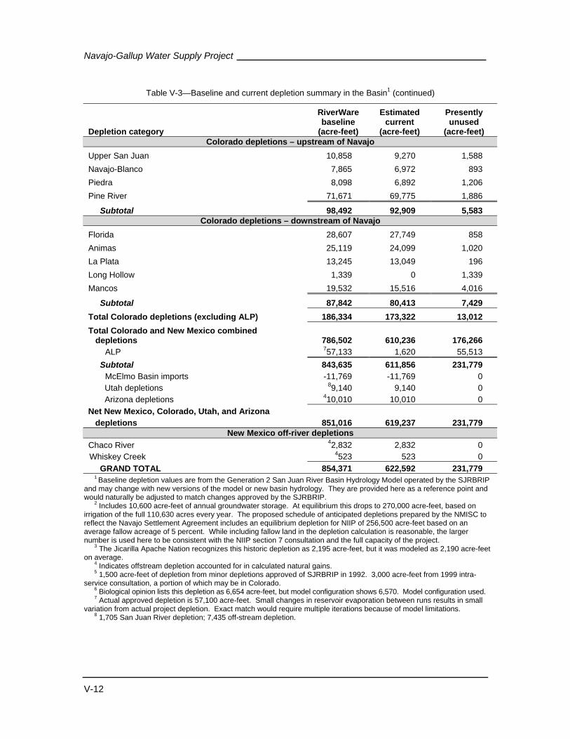
Table V-3—Baseline and current depletion summary in the Basin1 (continued)
Depletion category
RiverWare baseline
(acre-feet)
Estimated current
(acre-feet)
Presently unused
(acre-feet) Colorado depletions – upstream of Navajo
Upper San Juan 10,858 9,270 1,588 Navajo-Blanco 7,865 6,972 893 Piedra 8,098 6,892 1,206 Pine River 71,671 69,775 1,886
Subtotal 98,492 92,909 5,583 Colorado depletions – downstream of Navajo
Florida 28,607 27,749 858 Animas 25,119 24,099 1,020 La Plata 13,245 13,049 196 Long Hollow 1,339 0 1,339 Mancos 19,532 15,516 4,016
Subtotal 87,842 80,413 7,429
Total Colorado depletions (excluding ALP) 186,334 173,322 13,012
Total Colorado and New Mexico combined depletions 786,502 610,236 176,266
ALP 757,133 1,620 55,513 Subtotal 843,635 611,856 231,779
McElmo Basin imports -11,769 -11,769 0 Utah depletions 89,140 9,140 0 Arizona depletions 410,010 10,010 0 Net New Mexico, Colorado, Utah, and Arizona depletions 851,016 619,237 231,779
New Mexico off-river depletions Chaco River 42,832 2,832 0 Whiskey Creek 4523 523 0 GRAND TOTAL 854,371 622,592 231,779
1 Baseline depletion values are from the Generation 2 San Juan River Basin Hydrology Model operated by the SJRBRIP and may change with new versions of the model or new basin hydrology. They are provided here as a reference point and would naturally be adjusted to match changes approved by the SJRBRIP. 2 Includes 10,600 acre-feet of annual groundwater storage. At equilibrium this drops to 270,000 acre-feet, based on irrigation of the full 110,630 acres every year. The proposed schedule of anticipated depletions prepared by the NMISC to reflect the Navajo Settlement Agreement includes an equilibrium depletion for NIIP of 256,500 acre-feet based on an average fallow acreage of 5 percent. While including fallow land in the depletion calculation is reasonable, the larger number is used here to be consistent with the NIIP section 7 consultation and the full capacity of the project. 3 The Jicarilla Apache Nation recognizes this historic depletion as 2,195 acre-feet, but it was modeled as 2,190 acre-feet on average. 4 Indicates offstream depletion accounted for in calculated natural gains. 5 1,500 acre-feet of depletion from minor depletions approved of SJRBRIP in 1992. 3,000 acre-feet from 1999 intra-service consultation, a portion of which may be in Colorado. 6 Biological opinion lists this depletion as 6,654 acre-feet, but model configuration shows 6,570. Model configuration used. 7 Actual approved depletion is 57,100 acre-feet. Small changes in reservoir evaporation between runs results in small variation from actual project depletion. Exact match would require multiple iterations because of model limitations. 8 1,705 San Juan River depletion; 7,435 off-stream depletion.

Chapter V – Affected Environment and Environmental Consequences
V-13
Water Uses and Resources – Methodology The following measures were used to evaluate the impacts to water rights and uses under the No Action, SJRPNM, and NIIP Amarillo Alternatives.
• Researching the number of water rights and quantifying the amounts of water associated with each water right
• Researching available water diversion records and determining possible impacts
due to changes in flows in the San Juan River resulting from operation of the proposed project
• Examining and comparing a hydrologic model output for each construction
alternative to the No Action Alternative to determine possible variations in flow from the future operation of the proposed project and the way in which these variations may affect water use (Reclamation, 2004)
• Observing actual operations of the diversion structures during the Navajo Dam
Summer Low Flow Test conducted from July 9 to July 15, 2001 (Reclamation, 2002b) Water Uses and Resources – Impact Indicators The following assumptions and conditions were made for the analysis:
(1) An underlying assumption in analysis of the impact to water resources was that New Mexico water law, based on the prior appropriation doctrine, would be maintained. All existing depletions are intended to be represented in the hydrology model used for analysis. Comparing the model depletions with and without the action reveals differences among alternatives.
(2) Future uses with valid water rights and environmental clearances, when
necessary, were handled in the same manner as existing water uses using the same impact indicators (e.g., completion of the NIIP was modeled as a depletion for its full water rights acreage).
(3) Navajo Dam would be operated as described in the preferred alternative in the
Navajo Dam Operations FEIS to implement Flow Recommendations. In the Navajo Dam Operations FEIS, flow statistics were based on the modeled period of 1929–93 and compared to the Flow Recommendations criteria, and Navajo Dam operations were adjusted until the Flow Recommendations could be met. The inability to implement the SJRBRIP was considered to be an impact to the endangered fish. A Navajo Depletion Guarantee is included as a component of both action alternatives to ensure that proposed project depletions do not result in
Navajo-Gallup Water Supply Project
V-14
exceeding the depletions included in the current Flow Recommendations (encompasses all projects currently modeled in the ESA baseline at full development). The Navajo Depletion Guarantee is discussed in greater detail in Chapter VI–Environmental Commitments and Mitigation Measures.
(4) It should be considered whether there are any impacts on the following projects:
(1) Colorado Ute and Navajo Indian water uses pursuant to the Colorado Ute Indian Water Rights Settlement Act of 1988, P.L. 100-585, as amended (P.L. 106-554) (Ute Settlement Act) and the 2000 Settlement Act amendments (which also authorize the ALP Project and its component Navajo Nation Municipal Pipeline [NNMP]); (2) Jicarilla Apache Nation water uses pursuant to the Jicarilla Settlement Act; (3) completion of the NIIP; or (4) the exercise of senior Indian water rights for uses without environmental clearances (more detail is provided in the “Indian Trust Assets” section of this chapter).
(5) The Upper Basin States’ ability to develop and use their compact apportionment
and the use of Upper Basin water in the Lower Basin (Gallup/Window Rock areas) were taken into consideration.
Water Uses and Resources – Impacts Analysis No Action Alternative.—Reservoir elevations for the No Action Alternative would generally be lower than those under the action alternatives because additional water would not be stored in Navajo Reservoir to meet the demands of the proposed project. A combination of natural flows, bypasses, and releases from Navajo Reservoir would be used to meet existing downstream senior water rights and implement the Flow Recommendations. The spring releases would reach 5,000 cfs when sufficient water is available, and releases would be decreased to as low as 250 cfs when necessary to provide the recommended flows through the critical habitat area and to conserve water. A 250-cfs release from Navajo Reservoir during the irrigation season results in low flows from below the Citizens Ditch diversion to the Animas River confluence due to irrigation diversions; however, during the Navajo Dam Summer Low Flow Test, it was determined that a 250-cfs release would meet senior water rights (Reclamation, 2002b). Currently, some flexibility in reservoir releases exists because water committed under present water rights and/or future development is not fully used. This may be a significant amount of water in many, but not all, years. The release of this water is incorporated into operations to augment the minimum 250 cfs release during the irrigation season with a goal of minimum releases of 350 cfs. The application of impact indicators (see previous indicators discussion) was used to predict future resource conditions under the No Action Alternative. Release patterns would generally follow the pattern described in the 250/5000 Alternative (Flow Recommendations) as described in the Navajo Reservoir Operations FEIS. Many of the Navajo Nation residents would continue to haul water for domestic uses, and the

Chapter V – Affected Environment and Environmental Consequences
V-15
Navajo Nation and the city of Gallup would continue to use existing permitted groundwater wells. Additional water conservation would be needed to meet current and future water demands. The Jicarilla Apache Nation would need to construct alternate delivery facilities or sources of water for development of the southwestern portion of Jicarilla Apache Reservation lands. Under the No Action Alternative, the following water uses would continue:
(1) Future uses with valid water rights and environmental clearances (National Environmental Policy Act [NEPA] and ESA) would likely continue assuming that the SJRBRIP continues to function and serves as the reasonable and prudent measure (RPM) and/or reasonable and prudent alternative (RPA) for adverse impacts to listed species.
(2) Navajo Dam would continue to be operated to assist in meeting the Flow
Recommendations.
(3) The following projects and uses would continue: (1) Colorado Ute and Navajo Indian water uses pursuant to the 1988 Colorado Ute Settlement Act and the 2000 Settlement Act amendments (which also authorize the ALP Project and its component NNMP); (2) Jicarilla Apache Nation water uses pursuant to the Jicarilla Settlement Act; and (3) completion of the NIIP.
(4) The No Action Alternative would not limit the Upper Basin States’ right to
develop and use their compact apportionment. Apportionment planned for use in the proposed project may be available for other projects within the Basin.
(5) If the proposed project is not constructed as described in P.L. 111-11 and the
Navajo Settlement Agreement is not implemented, the Navajo Nation could be forced to reinitiate claims that would continue the uncertainty within the Basin and have significant adverse effects on other water users in the Basin. In addition, water conservation measures included in the No Action Alternative are not adequate to meet current and future water demands. The city of Gallup would likely attempt to expand its groundwater uses, which could face objections by many parties in the Gallup area.
SJRPNM Alternative.—Navajo Reservoir elevations for the SJRPNM Alternative would generally be higher than those of the No Action Alternative (1.3-foot increase in mean reservoir elevation) because of the increased storage needed, on average, to make releases from Navajo Reservoir meet project demands (table V-4). The proposed project is designed to divert a total of 37,764 AFY from the San Juan River with a resulting depletion of 35,893 acre-feet, based on 2040 projected population with a demand rate of 160 gallons per capita per day (gpcd). A total of 33,119 acre-feet would be diverted from the San Juan River at the PNM diversion (river mile [RM] 166.7), and

Navajo-Gallup Water Supply Project
V-16
4,645 acre-feet would be diverted through the existing NIIP facilities at Navajo Reservoir (RM 225) to Cutter Reservoir via the NIIP Canal system to meet project water demand.
Table V-4.—Navajo Reservoir content and releases for the alternatives
Alternative Project depletions from
the San Juan River Mean reservoir
elevations
Mean average flows for the
San Juan River1
No Action No project depletions 6,057.1 feet 1,444 cfs SJRPNM 35,893 acre-feet 1.3-foot increase 4.6-cfs increase NIIP Amarillo 35,893 acre-feet 0.9-foot increase 1.2-cfs decrease 1 Average of five San Juan River gauges.
A combination of natural flows, bypasses, and releases from Navajo Reservoir would be used to meet existing downstream senior water rights and the Flow Recommendations. During higher riverflows, natural riverflows would be used to meet the PNM diversion portion of the water demand. Mean average flows in the San Juan River would increase by 4.6 cfs to meet the PNM diversion portion of the water demand and to continue to meet Flow Recommendations downstream of the PNM diversion. Under certain low flow conditions, the SJRPNM Alternative would increase river base flows in the San Juan River from Navajo Dam to the PNM diversion (58.3 river miles) by as much as 16 percent, which would benefit other resources dependent on base flows. The application of evaluation criteria (see previous indicator discussion) disclosed the following potential impacts:
(1) Under the SJRPNM Alternative, there would be no adverse impact to existing active water use in the Basin.
(2) There would be no adverse impacts to future uses with valid water rights and
modeled in the current Flow Recommendations. Future uses were analyzed in the same manner as existing water uses under the same impact indicators (e.g., completion of NIIP was modeled as a depletion for its full water rights acreage).
(3) Navajo Dam would be operated as described in the ROD for the Navajo
Reservoir Operations FEIS to meet Flow Recommendations to the extent possible. In the Navajo Reservoir Operations FEIS, flow statistics were based on the modeled period of 1929–93 compared to the Flow Recommendations criteria, and Navajo Dam operations were adjusted until the Flow Recommendations could be met. The inability to implement the SJRBRIP was considered to be an impact to the endangered fish. Under the SJRPNM Alternative, all but two of the flow criteria are met for the worst-case scenario, and these criteria have been
Chapter V – Affected Environment and Environmental Consequences
V-17
determined by the Biology Committee to be ineffective in accomplishing the anticipated results (Miller, 2005). The 2,500 cfs criteria are missed by about 12 percent for 3 days in 1 year out of the 65-year period, or 0.01 percent of the time. All other Flow Recommendations are fully met. The U.S. Fish and Wildlife Service (Service) determined in its biological opinion (volume II, appendix C, part III) that “this reduction is not expected to have a measurable adverse effect for the endangered fish or their designated critical habitat and would not preclude recovery.”
(4) The following projects and uses would not be adversely impacted by the
SJRPNM Alternative: (1) Colorado Ute and Navajo Indian water uses pursuant to the 1988 Colorado Ute Settlement Act and the 2000 Settlement Act amendments (which also authorize the ALP Project and its component NNMP); (2) Jicarilla Apache Nation water uses pursuant to the Jicarilla Settlement Act; and (3) the completion of the NIIP.
(5) The SJRPNM Alternative is compatible with the Upper Basin States’ ability to
develop and use their compact apportionment. The use of Upper Basin water in the Lower Basin (Gallup/Window Rock areas) is also considered compatible. Therefore, no impact is predicted.
NIIP Amarillo Alternative.—Navajo Reservoir elevations for the NIIP Amarillo Alternative would generally be lower than those for the SJRPNM Alternative (0.9-foot increase) because of withdrawals made from Navajo Reservoir via the existing NIIP intake structure to meet the full amount of project demands (table V-4). The proposed project is designed to divert a total of 37,764 AFY from the San Juan River with a resulting depletion of 35,893 AFY based on the 2040 project population with a demand rate of 160 gpcd. A total of 37,764 acre-feet would be diverted through the existing NIIP facilities at Navajo Reservoir to Cutter Reservoir and a newly constructed 4,500 acre-foot active storage reservoir via the NIIP Amarillo Canal to meet project water demands. A combination of natural flows and releases from Navajo Reservoir would be used to meet existing downstream senior water rights and Flow Recommendations. Mean average flows in the San Juan River would decrease by 1.4 cfs to meet project demands. The application of the evaluations criteria for the NIIP Amarillo Alternative result in the same conclusions as those for the SJRPNM Alternative, with no adverse impacts identified. Water Uses and Resources – Mitigation Measures As part of the proposed project, the Navajo Nation provides a depletion guarantee to allow for full project development while not exceeding the existing depletion baseline (table V-3) or limiting the implementation of the SJRBRIP.
Navajo-Gallup Water Supply Project
V-18
Reclamation would track actual depletions for the NIIP and ALP Project through the 5-year consumptive use and loss reporting. When the sum of depletions for the NIIP and ALP Project reach a 290,000 acre-foot yearly average, more detailed accounting will be required. Additional detail on the Navajo Depletion Guarantee is included in Chapter VI – Environmental Commitments and Mitigation Measures. Water Resources and Uses – Summary of Impacts Under the No Action Alternative, existing and future water uses and projects with valid water rights and environmental clearances would continue to be constructed and/or operated and the elements of the SJRBRIP would continue to be implemented. The SJRPNM and NIIP Amarillo Alternatives (including the Navajo Depletion Guarantee, described in chapter VI) would result in missing the 2,500 cfs Flow Recommendation criteria 0.01 percent of the time.6 The Service determined that this reduction is not expected to have a measurable effect on the endangered fish or their critical habitat. Mean reservoir elevations would slightly increase under both action alternatives, but this change is not significant. Mean average San Juan River flows would increase by 4.6 cfs under the SJRPNM Alternative and decrease by 1.2 cfs under the NIIP Amarillo Alternative. The benefits of other resources from increased flows and reservoir elevations are discussed in greater detail for each resource in the sections of this chapter (Aquatic Resources, Vegetation Resources, Recreation Resources, and others).
Indian Trust Assets This section addresses the potential impacts to ITAs that could result from implementation of the No Action, SJRPNM, and NIIP Amarillo Alternatives. Issue: How would the No Action and action alternatives affect ITAs?
O v e r v i e w
Scope
The scope includes ITAs associated with Navajo Reservoir and the San Juan River and on surrounding trust/reservation lands of the Navajo and Jicarilla Apache Nations.
6 This assumes the SJRPNM and NIIP Amarillo Alternatives’ depletions would be 20,782 AFY, respectively, with the Navajo Depletion Guarantee.

Chapter V – Affected Environment and Environmental Consequences
V-19
Impact Indicators
An impact is considered to exist for any action that would:
• Adversely affect the value, use, or enjoyment of an ITA
• Disregard or subordinate the government-to-government relationship that exists between the United States and any affected Tribal Nation
Indian Trust Assets – Affected Environment Introduction.—The United States has a trust responsibility to protect rights reserved by or granted to Indian Tribes by treaty, statutes, and Executive orders. This trust responsibility requires that Federal agencies such as Reclamation take actions reasonably necessary to protect ITAs. Interior Secretarial Order Number 3215, dated April 28, 2000, further states:
The proper discharge of the Secretary’s trust responsibility requires, without limitation, that the Trustee, with a high degree of care, skill, and loyalty: Protect and preserve Indian Trust Assets from loss, damage, unlawful alienation, waste, and depletion.
Reclamation ITA policy states that Reclamation will carry on its activities in a manner that protects ITAs and avoids adverse impacts to ITAs when possible. When Reclamation cannot avoid adverse impacts, it will provide appropriate mitigation or compensation (Reclamation, 1994 and 1998). A basic description of ITAs is as follows:
• ITAs are legal interests in assets held in trust by the Federal Government for federally recognized Indian Tribes or Nations.
• Assets are anything owned that has monetary value. The assets need not be
owned outright, but could be some other type of property interest, such as a lease or a right to use something. Assets can be real property, physical assets, or intangible property rights.
• A trust has three components: the trustee, the beneficiary, and the trust asset(s).
The beneficiary is also sometimes referred to as the beneficial owner of the trust asset. In this trust relationship, title to ITAs is held by the United States (trustee) for the benefit of a Tribal Nation.

Navajo-Gallup Water Supply Project
V-20
• Legal interest means there is a property interest for which a legal remedy, such as compensation or an injunction, may be obtained if there is improper interference.
• ITAs do not include things in which a Tribal Nation has no legal interest
(e.g., off-reservation sacred sites in which a Tribe has no legal property interest are generally not considered ITAs).
• ITAs cannot be sold, leased, or otherwise alienated without the United States’
approval. While most ITAs are located on the reservation, they also can be located off-reservation. Examples include lands, minerals, water rights, hunting and fishing rights, other natural resources, money, or claims.
Letters requesting identification and consultation on ITA issues were sent to 24 Tribal governments. Potential ITAs were identified for four federally recognized Tribes within the Basin: the Navajo and Jicarilla Apache Nations, the Ute Mountain Ute Tribe, and the Southern Ute Indian Tribe. During these consultations, Reclamation concluded that ITAs potentially affected by the proposed Federal action were limited to water rights and land use (easements, including Trust lands and Tribal allotments, necessary for project construction and operation). The proposed action is not expected to affect any treaty-based fishing, hunting or gathering, or similar rights of access use on traditional Tribal lands. In Winters v. United States, the U.S. Supreme Court laid the foundation for Indian water rights that have become known as Winters Doctrine rights. The court held that the establishment of an Indian reservation carries with it an implied amount of water necessary to satisfy the purposes of the reservation. A water right granted to a Tribal Nation under the Winters Doctrine is given a priority date no later than the time when the reservation was established and, unlike water rights permitted, licensed, or adjudicated under State statutes, such rights under the Winters Doctrine cannot be lost through non-use. Native American Graves Protection and Repatriation Act of 1990 (NAGPRA)7 cultural items and other cultural property may be considered ITAs by association with land status, treaty, or some other statute, but are not considered ITAs by virtue of NAGPRA alone. Therefore, cultural resource issues and mitigation, including sacred sites and NAGPRA issues, are addressed separately in the “Cultural Resources” section in this chapter. Approximately 60 percent of the land within the Basin is entrusted to the reservation lands of the Navajo and Jicarilla Apache Nations, Southern Ute Indian Tribe, and Ute Mountain Ute Tribe. Winters Doctrine water right settlements in the San Juan River
7 A Federal law, passed in 1990, that provides a process for museums and Federal agencies to return such Native American cultural items as human remains, funerary objects, sacred objects, and objects of cultural patrimony to lineal descendants, culturally affiliated Indian Tribes, and Native Hawaiian organizations.

Chapter V – Affected Environment and Environmental Consequences
V-21
Basin have been negotiated and finalized for the Jicarilla Apache Nation, Ute Mountain Ute, and Southern Ute Indian Tribes. Not all reserved water rights under the Winters Doctrine for the Navajo Nation have been quantified or settled; however, P.L. 111-11 authorizes the Secretary to execute an agreement consistent with the provision of the act that settles the Nation’s San Juan River Basin reserved water claims in New Mexico. Existing and future Tribal uses of San Juan River water are shown in table V-5. A discussion of the affected environment for each Tribe and Tribal allotments follows. Navajo Nation.—The affected environment for this analysis includes much of the eastern and northern portions of the Navajo Nation (where adequate domestic water service is lacking); the lands within the NIIP service area; lands served along the Hogback, Fruitland-Cambridge, and Cudei irrigation projects; irrigation along the tributaries to the San Juan River; and 43 Navajo chapters (communities) within the proposed project service area discussed previously in chapter II. The Navajo Indian Reservation was established by treaty in 1868 (15 Stat. 667) and was expanded by Executive orders and statutes between 1868 and 1934. The Navajo Nation lands total approximately 26,897 square miles and extend into New Mexico, Arizona, and Utah. The San Juan River runs through the original 1868 reservation, is a major source of water for Navajo Nation agricultural and domestic use, and is the only water source in the northern portion of the reservation capable of being readily developed. Basin water also is used for Tribal mineral development such as the Navajo Mine and production of coal-bed methane. About one-half of all Navajo Nation lands lie within the Basin. The Navajo Nation has substantial water rights in the Basin, based on historical use and reserved water rights (Winters Doctrine rights); however, as mentioned previously, not all reserved rights have been quantified through settlement or litigation. The Navajo Nation claims a priority date of no later than 1849 for its water rights, based on the treaty with the United States in that year (Interior, 2000a), even though the reservation was not established until 1868. Because significant areas of arable Navajo Nation lands lie within the Basin, the Navajo Nation claims a significant amount of the water in the San Juan River. This is based on the practicably irrigable acreage (PIA) standard enunciated in the Supreme Court case of Arizona v. California. The ultimate amount of the Navajo Nation’s water rights in the Basin in Arizona and Utah, including diversion and use of water from the San Juan River, may depend either on PIA analyses to be prepared by the BIA and litigation of the Nation’s claims in water rights adjudications, or on the negotiation of water rights settlements between the Navajo Nation and each of the States. The Navajo Settlement Agreement, approved by the Congress, quantifies the Navajo Nation’s water rights in the Basin within the State of New Mexico. The proposed project is a key component of the proposed Navajo Settlement Agreement, included in P.L. 111-11. P.L. 111-11 requires the Secretary to execute an agreement consistent with the provisions of the act by December 31, 2010, and to complete project construction by 2024.

Navajo-Gallup Water Supply Project
V-22
Table V-5.—Summary of major existing and future Tribal uses of Basin water
Description Diversion
(AFY) Depletion
(AFY)
Included in environmental baseline1 for
recent ESA
consultations
Existing uses – Navajo Nation2
NIIP (Blocks 1–8)3 149,420 Yes
Hogback Project 12,100 Yes
Cudei Irrigation Project 900 Yes
Fruitland 7,898 Yes
Existing uses – Navajo Nation (New Mexico State water rights)
Shiprock Helium Plant (permit 2472) 1,400 Yes
Kerr McGee (uranium processing) (permit 2875) 700 Yes
Kerr McGee (permit 2807) 500 Yes
Navajo Methodist School (Navajo Academy) 139.5 Yes
Existing uses – Jicarilla Apache Nation
Decreed for historic and existing uses, 1880 priority date 5,683 2,195 Yes
Small third-party water service contracts 770 4770 Yes
PNM third-party water service contract (pursuant to the 1992 Jicarilla Settlement Act)
16,200 16,200 Yes
Evaporation – stock ponds and reservoirs 2,187 Yes
Existing uses – Ute Mountain Ute Tribe
Dolores Project 25,100 N/A5
Existing uses – Southern Ute Indian Tribe
Water allocated to the Tribe from the Florida Project 2,000 Yes
Pine River 181.7 cfs and 1/6 interest in Vallecito Reservoir Yes
San Juan River, 5.64 cfs direct diversion rights, 1868 priority date 1,014 Yes
Piedra River, 2.0 cfs direct diversion, 1868 priority date 600 Yes
Chapter V – Affected Environment and Environmental Consequences
V-23
Table V-5.—Summary of major existing and future Tribal uses of Basin water (continued)
Description Diversion
(AFY) Depletion
(AFY)
Included in environmental baseline1 for
recent ESA
consultations
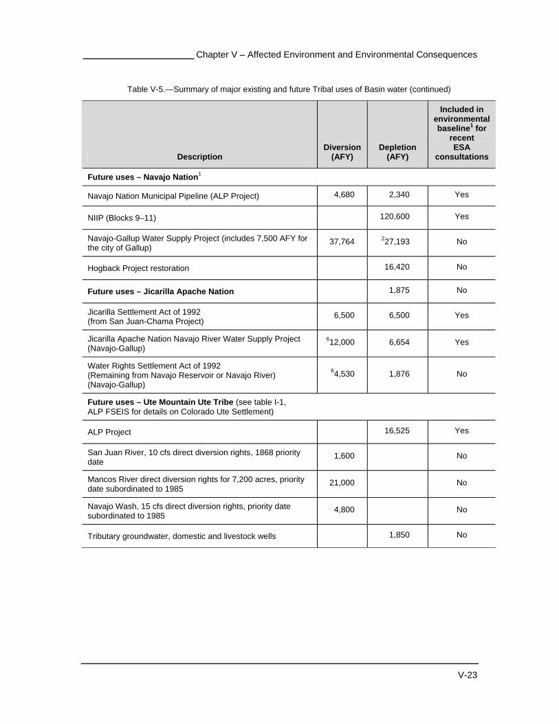
Future uses – Navajo Nation1
Navajo Nation Municipal Pipeline (ALP Project) 4,680 2,340 Yes
NIIP (Blocks 9–11) 120,600 Yes
Navajo-Gallup Water Supply Project (includes 7,500 AFY for the city of Gallup) 37,764 227,193 No
Hogback Project restoration 16,420 No
Future uses – Jicarilla Apache Nation 1,875 No
Jicarilla Settlement Act of 1992 (from San Juan-Chama Project) 6,500 6,500 Yes
Jicarilla Apache Nation Navajo River Water Supply Project (Navajo-Gallup)
612,000 6,654 Yes
Water Rights Settlement Act of 1992 (Remaining from Navajo Reservoir or Navajo River) (Navajo-Gallup)
64,530 1,876 No
Future uses – Ute Mountain Ute Tribe (see table I-1, ALP FSEIS for details on Colorado Ute Settlement)
ALP Project 16,525 Yes
San Juan River, 10 cfs direct diversion rights, 1868 priority date 1,600 No
Mancos River direct diversion rights for 7,200 acres, priority date subordinated to 1985 21,000 No
Navajo Wash, 15 cfs direct diversion rights, priority date subordinated to 1985 4,800 No
Tributary groundwater, domestic and livestock wells 1,850 No
Navajo-Gallup Water Supply Project
V-24
Table V-5.—Summary of major existing and future Tribal uses of Basin water (continued)
Description Diversion
(AFY) Depletion
(AFY)
Included in environmental baseline1 for
recent ESA
consultations
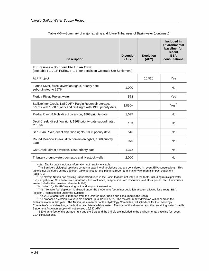
Future uses – Southern Ute Indian Tribe (see table I-1, ALP FSEIS, p. 1-6 for details on Colorado Ute Settlement)
ALP Project 16,525 Yes
Florida River, direct diversion rights, priority date subordinated to 1976 1,090 No
Florida River, Project water 563 Yes
Stollsteimer Creek, 1,850 AFY Pargin Reservoir storage, 5.5 cfs with 1868 priority and refill right with 1986 priority date 1,850+ Yes7
Piedra River, 8.9 cfs direct diversion, 1868 priority date 1,595 No
Devil Creek, direct flow right, 1868 priority date subordinated to 1976 183 No
San Juan River, direct diversion rights, 1868 priority date 516 No
Round Meadow Creek, direct diversion rights, 1868 priority date 975 No
Cat Creek, direct diversion, 1868 priority date 1,372 No
Tributary groundwater, domestic and livestock wells 2,000 No
Note: Blank spaces indicate information not readily available. 1 The Service’s biological opinions contain a baseline of depletions that are considered in recent ESA consultations. This table is not the same as the depletion table derived for this planning report and final environmental impact statement (table V-3). 2 The Navajo Nation has existing unquantified uses in the Basin that are not listed in the table, including municipal water uses, irrigation on San Juan River tributaries, livestock uses, evaporation from reservoirs, and stock ponds, etc. These uses are included in the baseline table (table V-3). 3 Includes 16,420 AFY from Hogback and Hogback extension. 4 This 770 acre-foot depletion is allowed under the 3,000 acre-foot minor depletion account allowed for through ESA (section 7) consultation under the SJRBRIP. 5 This 25,100 acre-feet is imported from the Dolores River Basin and consumed in the Basin. 6 The proposed diversion is a variable amount up to 12,000 AFY. The maximum new diversion will depend on the available water in that year. The Nation, as a member of the Hydrology Committee, will introduce for the Hydrology Committee’s consideration, a method to calculate available water. The sum of this diversion and the remaining water Jicarilla Settlement Act water supply will not exceed 16,530 AFY. 7 530.6 acre-feet of the storage right and the 2 cfs and the 3.5 cfs are included in the environmental baseline for recent ESA consultations.

Chapter V – Affected Environment and Environmental Consequences
V-25
Only the NIIP, the three San Juan River projects in New Mexico (Hogback, Fruitland, and Cudei), and a small project near Aneth, Utah, would potentially be affected by the proposed project because of the Navajo Depletion Guarantee. While production of irrigation tracts or projects on-reservation remain important to the Navajo Nation, it is not currently economically practicable to construct pipelines and pump San Juan River water to the many irrigation tracts or projects scattered throughout Navajo Nation lands. The SJRPNM and NIIP Amarillo Alternatives would be compatible with existing and planned future Navajo Nation water development projects as well as the Navajo Nation reserved water rights that have not been quantified. Descriptions follow for several of the largest existing and planned Indian water development projects in the Basin; however, the Navajo Nation’s water development interests are not limited to these projects (Navajo Nation, 2000a). Navajo Indian Irrigation Project.—Navajo Reservoir is the principal water storage facility for the NIIP. P.L. 87-483, enacted in 1962, authorized the Secretary to construct, operate, and maintain the NIIP for the purpose of furnishing irrigation water to approximately 110,630 acres. The NIIP, at the time of project authorization, was anticipated to require an average annual diversion of up to 508,000 AFY. The Agreement between the United States and the Navajo Tribe of Indians for Delivery of Water from Navajo Reservoir, executed in 1976, repeats the authorization language from P.L. 87-483, Section 2. However, the diversion amount of 508,000 AFY was the design diversion amount for flood irrigation of 110,630 acres, a large portion of which were to be located west of Chaco Wash and from Shiprock to the north to Newcomb in the south. The NIIP was later reconfigured to:
(1) Place all the proposed project acreage east of the Chaco River, which greatly reduced the overall canal length and water conveyance losses
(2) Install pressure sprinkler irrigation, which improved irrigation efficiency
(3) Reduce farm delivery operations
It is estimated that the redesigned NIIP will require a diversion, on average, of between 337,500 AFY and 372,000 AFY to irrigate 110,630 acres each year, depending on the implementation and success of planned water conservation measures. Also, actual irrigation diversions could be less depending upon land fallowing and farm management practices. The NIIP includes a water storage and delivery system, lands, roads, utilities, and other facilities for irrigation of project lands located south of Farmington, New Mexico. The Navajo Agricultural Products Industry (NAPI) is a Navajo Nation business enterprise formed in 1970 to develop, farm, operate, and manage the NIIP lands. Both the NIIP and
Navajo-Gallup Water Supply Project
V-26
the NAPI were established to provide a profit and employment to the Navajo people; they currently provide approximately 250 permanent jobs and 800 seasonal jobs. The NIIP is being developed in 11 separate blocks of approximately 10,000 acres of irrigable land each. The Congress began funding NIIP construction in 1963, and the project began operation in 1976 with the first 10,000-acre block. The project was scheduled for completion in 1986, but funding delays postponed completion. In 2002, facilities to deliver irrigation water to about 65,000 acres in Blocks 1 through 8 were complete. The acreage through Block 8 totals about 76,481 acres. Construction on Blocks 9, 10, and 11 was scheduled to be completed by 2012, with full irrigation acreage to be reached in 2032. This schedule may not be met because of limited congressional funding. San Juan River Irrigation Projects.—These irrigation projects along the San Juan River were initiated between 1900 and 1937. In 2000, these projects provided irrigation water to about 5,300 acres.
(1) The Hogback Irrigation Project supplies water for lands on the north side of the San Juan River, from the Hogback, located about 9 miles east of Shiprock, New Mexico, to about 17 miles northwest of Shiprock. In recent years, the acreage irrigated under the Hogback Irrigation Project has ranged from an estimated 2,580 acres to about 2,830 acres. In 1991, 16,420 AFY of depletion of the inactive portions of the Hogback Irrigation Project was applied to the NIIP for ESA consultation purposes. Construction of NIIP Blocks 1 through 8 was to proceed while research on endangered fish recovery took place.
(2) The Cudei Project supplies water for lands on the south side of the San Juan
River about 6 miles northwest of Shiprock. In recent years, the acreage irrigated under the Cudei Project has ranged from an estimated 290 acres to 390 acres. The Cudei diversion dam was removed in 2002, and supply to the proposed project was provided via a siphon from the Hogback main canal.
(3) The Fruitland Irrigation Project diversion dam and headworks are located
2 miles west of Farmington, New Mexico, on the south bank of the San Juan River. In recent years, the acreage irrigated under the Fruitland Irrigation Project, including Cambridge, has ranged from an estimated 1,950 acres to about 2,140 acres. The Cambridge Irrigation Project is supplied by the Fruitland Irrigation Project, and in 2000, about 60 acres were irrigated in the Cambridge Project area.
Navajo Nation Municipal Pipeline.—The NNMP is authorized as a structural component of the ALP Project under the Colorado Ute Indian Water Rights Settlement Act of 1988, P.L. 100-585, as amended (P.L. 106-554) (Colorado Ute Settlement Act) to augment a

Chapter V – Affected Environment and Environmental Consequences
V-27
30-year old pipeline that serves almost 60 percent of the current domestic water uses occurring along the San Juan River between Farmington and Shiprock. The pipeline will deliver 4,680 AFY of water diverted from the Animas River to supply a depletion of 2,340 AFY (Reclamation, 2000a). Other Navajo Nation ITAs.—In addition to water rights, the Navajo Nation Reservation land uses would be affected by the proposed project. These ITAs include Trust lands necessary for the construction and operation and maintenance (O&M) of the proposed project pipelines and associated facilities. The BIA administers these Trust lands for the benefit of the Navajo Nation. Other identified Navajo ITAs include the Navajo Tribal Utility Authority (NTUA) Shiprock Public Water System, other NTUA public water systems, and mineral and coal resources. Land uses potentially affected would include homesites, grazing assignments, leases, and transportation corridors administered by the local Navajo chapters and the BIA. The proposed project has the potential to temporarily affect up to 32,686 acres and permanently affect 249 acres of Navajo Nation Trust Lands (assuming an area of disturbance of 500 feet from the centerline on each side of the proposed pipeline project during construction, a 100-foot right-of way needed for O&M of the pipeline and placement of permanent project facilities). These impacts are discussed in greater detail in the “Vegetation Resources” and “Land Use” sections of this chapter. Jicarilla Apache Nation.—The Jicarilla Apache Indian Reservation was created by a series of Executive orders between 1874 and 1908. The reservation covers about 880,000 acres in north-central New Mexico. The reservation lies in both Rio Arriba and Sandoval Counties and includes 137,150 acres of land purchased by the Apache Nation. About 80 percent of the reservation is on the west side of the Continental Divide in the Basin. The western boundary of the reservation is about 15 miles east of Navajo Reservoir. The Navajo River, which is tributary to the San Juan River, is a perennial stream on the reservation. The San Juan-Chama Project8 diverts approximately 50 percent of the average annual flow of the Navajo River upstream of the Jicarilla Apache Reservation. Downstream from the reservation, Navajo Reservoir impounds the water. The Jicarilla Apache Nation was not included initially as a beneficiary of either of these Federal water resource development projects. Settlement negotiations between the Jicarilla Apache Nation and the United States began in 1985. Central to the negotiation effort was an updated hydrology study that resulted in the Secretary submitting to the Congress a 1988 Hydrologic Determination for the Upper
8 For a full description of the San Juan-Chama Project, see the “Connected, Cumulative, and Related Actions” section of this chapter.
Navajo-Gallup Water Supply Project
V-28
Colorado River Basin. According to the hydrologic determination, water was available within New Mexico’s Upper Basin apportionment for development and settlement of the Jicarilla Apache Nation’s Federal reserved water right claims. In October 1992, the Jicarilla Settlement Act became law (160 Stat. 2237). The water delivery provisions for future uses in the settlement act mandated certain requirements to be fulfilled before water could be made available for Tribal use. All of these requirements were met, and on February 23, 1999, the Jicarilla Apache Nation water rights in the San Juan River were adjudicated in District Court, San Juan County, New Mexico. As part of the Jicarilla Settlement Act, the Congress approved a settlement contract between the Nation and the Secretary to provide for the diversion by the Nation of 33,500 AFY, with a corresponding depletion of 25,500 AFY, from the Navajo Reservoir water supply at or above the reservoir, and to provide for the delivery to the Nation of 6,500 AFY at Heron Reservoir through the San Juan-Chama Project as part of the proposed project’s yield. Water to be supplied under the contract with the Secretary is the same priority as the water rights for Navajo Reservoir and the NIIP and must share shortages with other contractors of the Navajo Reservoir supply, including the NIIP. The Jicarilla Settlement Act also allows the Jicarilla Apache Nation to market its Navajo Reservoir supply and San Juan-Chama Project water through third-party contracts, consistent with Federal and State laws. Consistent with the Jicarilla Settlement Act, Interior works with the Jicarilla Apache Nation to facilitate use of water pursuant to the settlement contract and subcontracts between the Jicarilla Apache Nation and third parties that have been approved by the Secretary. Under the partial final decree in the San Juan River adjudication, the Jicarilla Apache Nation has a reserved water right for historic and existing uses not to exceed an annual diversion of 5,683 AFY or the quantity necessary to supply a depletion of 2,195 acre-feet, whichever is less, and a net evaporation of 2,187 acre-feet. These water rights retain a priority date of 1880. A variety of development options for these water rights is being pursued by the Jicarilla Apache Nation, including third-party water leases and on-reservation water use. The Jicarilla Apache Nation has leased water to several small contractors and to the PNM. In 2006, the PNM third-party subcontract began putting to beneficial consumptive use up to 16,200 AFY of the Jicarilla Apache Nation’s Navajo Reservoir supply contract water. The Jicarilla Apache Nation is also pursuing use of its remaining portion of the 25,500 AFY of depletion from the Navajo Reservoir water supply, including possible implementation of the Jicarilla Apache Nation Navajo River Water Supply Project (JANNRWSP) that would result in a consumptive use of up to 6,654 AFY. For this analysis, it was assumed that the Jicarilla Apache Nation would not use its Navajo Reservoir supply contract to implement the JANNRWSP and that the Nation would instead make available 8,530 AFY of depletion from its Navajo Reservoir supply contract

Chapter V – Affected Environment and Environmental Consequences
V-29
water and 170 AFY of depletion from some of its historic use reserved rights that currently are not used to supply the uses of water to be made under the proposed project by both the Jicarilla Apache Nation (1,200 AFY) and the city of Gallup (7,500 AFY). For purposes of this analysis, it is assumed that the JANNRWSP would divert no future use water, 2,020 AFY of depletion of the historical water right would be used for other purposes, and 8,700 acre-feet would be delivered to this project (6,570 acre-feet previously committed to JANNRWSP plus 1,960 acre-feet of additional future use water and 170 acre-feet of other water) to meet the full demands anticipated from the Jicarilla Apache Nation water rights. Colorado Ute Indian Tribes.—The original Ute Indian Reservations were carved out of the historical Ute homelands in 1868. The present lands of the Ute Mountain Ute and Southern Ute Indian Tribes are in southwestern Colorado and northwestern New Mexico. The Ute Mountain Ute lands include 890 square miles in Colorado and New Mexico. Southern Ute Indian Trust Lands include 470 square miles within the Tribe’s 1,250 square miles of checkerboard reservation. Seven rivers in southwestern Colorado flow through the Southern Ute and Ute Mountain Ute Reservations. The Colorado Ute Indian Water Rights Final Settlement Agreement was signed on December 10, 1986, and quantified the Colorado Ute Tribes’ water rights in the San Juan and Dolores River Basins in the State of Colorado. A large portion of the Colorado Ute Settlement Act is being implemented by the Ute Mountain Ute Tribe through the participation in the Dolores Project and by the Ute Mountain Ute and Southern Ute Indian Tribes’ participating in the ALP Project; however, these two projects do not fully implement the act. The Tribes also have water rights in other rivers that do not involve the Dolores or ALP Projects; they are presently using the other rights or have plans to use them. (Future use water rights granted under the act were provided in table V-5). Collectively, the Colorado Ute Tribes have approximately up to 36,104 acre-feet of future use direct diversion and groundwater that may not be included in the existing ESA baseline. Additional section 7 consultations may be necessary if a Federal nexus exists for the development of these water rights. Tribal Allotments.—In 1887, the Congress passed the General Allotment Act (24 Stat. 388, ch. 119, 25 USCA 331). The allotment act was applied to reservations by the President whenever, in his opinion, it was advantageous for particular Indian Tribes. Members of the selected Tribe or reservation were given permission to select pieces of land—usually around 40 to 160 acres in size—for themselves and their children. If the amount of reservation land exceeded the amount for allotment, the Federal Government could negotiate to purchase the land from the Tribes and then sell it to non-Tribal settlers. Sixty million acres were either ceded outright or sold to non-Indian homesteaders and corporations as “surplus lands.” Under the General Allotment Act, Indians had only partial ownership because the United States considered itself to have legal title to the land.

Navajo-Gallup Water Supply Project
V-30
In 1934, the Howard-Wheeler Act, also known as the Indian Reorganization Act (48 Stat. 984), prohibited further allotment of Indian lands; extended periods of trust and restrictions on allotted lands; authorized the Secretary to restore Tribal ownership to the remaining surplus lands of an Indian reservation; prohibited transfers of restricted Indian land, individually owned or otherwise, except to an Indian Tribe; and authorized the acquisition of lands, water rights, surface rights, and interest by the U.S. Government for Indians and declares that purchased lands be tax exempt. Indian Trust Assets – Methodology Much of the ITA analysis was based on the review of documents concerning potentially impacted ITAs, with a focus on water rights. These documents include the Jicarilla Settlement Act; Colorado Ute Settlement Act; Secretarial Orders 3175 and 3206; various Interior and Reclamation guidelines and procedures; and available economic development, water development, and natural resource management plans for the Navajo and Jicarilla Apache Nations; Act of June 13, 1962, authorizing the construction and O&M of the NIIP and the initial stage of the San-Juan Chama Project as Colorado River Storage Project (CRSP) participating projects; the 2000 Final Supplement to the Environmental Impact Statement for the ALP Project; and the Navajo Reservoir Operations FEIS (Reclamation, 2006) for Navajo Reservoir Operations. Correspondence between the Tribal Nations and Reclamation concerning ITAs were also reviewed. In addition, Reclamation held meetings with Tribal representatives to obtain their interpretations and assessments of ITAs that could be affected by the proposed Federal action. The Navajo and Jicarilla Apache Nations and BIA are active members of the project planning report’s steering committee and are cooperating agencies in the development of this planning report and final environmental impact statement (PR/FEIS). Information about project issues was obtained from the Navajo Nation’s Department of Water Resources, Navajo Fish and Wildlife Department (NFWD), Jicarilla Apache Nation’s Water Commission, and the Jicarilla Apache Department of Natural Resources. Additional consultation between Reclamation and the Southern Ute Indian Tribe also occurred. Indian Trust Assets – Impacts Analysis Reclamation sent letters to the following 24 Tribal governments requesting assistance in identifying potentially affected ITAs: all Pueblos, Ute Mountain Ute, Southern Ute Indian Tribe, Navajo Nation, Jicarilla Apache Nation, and Hopi Tribe. Reclamation received responses back from the Hopi Tribe, Navajo Nation, Jicarilla Apache Nation, and Southern Ute Indian Tribe. Consultations with potentially affected Indian Tribes have been completed. Copies of Tribal comment letters are included in volume III. Consultation between Reclamation and the Southern Ute Indian Tribe focused on

Chapter V – Affected Environment and Environmental Consequences
V-31
Southern Ute water rights included within the existing environmental baseline. Reclamation concluded that the information presented in table V-5 represents current Tribal water rights included in recent ESA consultations. The SJRBRIP is intended to provide ESA coverage for future Tribal projects with a Federal nexus not included in recent ESA consultations as described in the SJRBRIP principles ESA section 7 consultations document (attachment O). SJRPNM Alternative.—Depletions associated with the SJRPNM Alternative added to the existing ESA baseline depletions (table V-3) exceed the ability of Navajo Reservoir to meet current Flow Recommendations. The Navajo Nation developed a Navajo Depletion Guarantee that would keep the proposed project from impacting the current Flow Recommendations and allow full project development within the existing ESA baseline. With the Navajo Depletion Guarantee, the proposed project meets the critical elements of the Flow Recommendations. The Navajo Nation depletion of 27,193 AFY would be allocated between New Mexico and Arizona. Water rights settlement negotiations are underway in both New Mexico and Arizona to determine the quantity of water available for the proposed project among other uses. The Navajo Settlement Agreement would, when executed by the Secretary under P.L. 111-11, provide the Navajo Nation the right to consumptively use up to 20,782 acre-feet in any year for its uses under the proposed project with the State of New Mexico, and it is anticipated that water rights in Arizona will be made available to permit the Navajo Nation to consumptively use up to 6,411 acre-feet in any year for its uses under the proposed project within the State of Arizona and within the allocations of water made to the State of Arizona by compact or decree. Separate Navajo Reservoir water supply contracts with the Secretary will be needed for the delivery of water from Navajo Reservoir and the San Juan River to the Navajo Nation’s project uses in New Mexico and Arizona. Navajo Nation vegetation and land use resources associated with the SJRPNM Alternative are discussed in greater detail under the appropriate resource. Easements for pipelines through Tribal allotments would be acquired through the BIA and negotiated on an individual basis. The 1,200 acre-foot demand for the Jicarilla Apache Nation would be met by delivery of a portion of their 25,500 acre-foot contract allocation from the Navajo Reservoir water supply as a result of the Jicarilla Settlement Act or a portion of their unused historical rights. Contingent upon successful negotiation of a subcontract between the Jicarilla Apache Nation and the city of Gallup, the 7,500 acre-foot demand for the city would be met with deliveries of the Navajo Reservoir water supply subcontracted from the Jicarilla Apache Nation to the city. The Secretary would need to approve the subcontract. Approximately 36,104 acre-feet of Tribal future use water may not be included in the existing environmental baseline. Additional depletions over and above the proposed

Navajo-Gallup Water Supply Project
V-32
project may result in violations of critical elements of the Flow Recommendations. Tribal water developments that include a Federal nexus would require additional ESA section 7 consultation. The SJRBRIP is intended to serve as the RPA for actions that may cause jeopardy to the endangered fish. Additional information on the SJRBRIP is provided in chapter I. NIIP Amarillo Alternative.—Impacts to ITAs under the NIIP Amarillo Alternative would be similar to those described for the SJRPNM Alternative. Vegetation and land use impacts associated with the NIIP Amarillo Alternative are discussed in greater detail under the appropriate resource. Indian Trust Assets – Mitigation Measures No mitigation measures are proposed. Indian Trust Assets – Summary of Impacts The SJRPNM and NIIP Amarillo Alternatives would provide needed domestic water supplies for both the Navajo and Jicarilla Apache Nations. Implementation of these alternatives may make it more difficult for the Colorado Ute Tribes to obtain non-jeopardy biological opinions to develop future use water rights (see table V-3) without reliance on implementation of the SJRBRIP. The SJRBRIP is intended to serve as the RPA to avoid jeopardy for future water development.
Water Quality This section discusses the potential impacts to water quality that could result from operation of the alternatives considered and associated operation of Navajo Dam and Reservoir. Issue: How would the No Action and action alternatives affect water quality and the
attainment of water quality standards?
O v e r v i e w
Scope
Navajo Reservoir and the San Juan River to Lake Powell.

Chapter V – Affected Environment and Environmental Consequences
V-33
Impact Indicators
Exceedences of Federal, State, and Tribal water quality standards were considered an adverse impact.
Water Quality – Affected Environment The San Juan River is characterized by good water quality when flows are released from Navajo Dam, but water quality progressively degrades downstream due to natural and induced bank erosion, diversions, agricultural and municipal use, and tributary contributions. The State of New Mexico has listed reaches of the San Juan River where water quality does not meet intended uses. Turbidity, fecal coliform, and bottom sediments impact the designated uses of the river most often. Several trace elements (selenium, aluminum, arsenic, mercury, copper, and zinc) have occasionally exceeded State standards from Navajo Dam to Farmington, New Mexico (Reclamation, 2000a). San Juan River water quality generally declines to Shiprock, New Mexico, with the stretch of the river between Farmington and Shiprock having the highest number of water quality standard exceedences. At the Four Corners gauge/sampling site, water quality improves and the number of exceedences decreases, but water quality declines again from Four Corners to Mexican Hat, Utah (Reclamation, 2000a). The State of New Mexico has issued fish consumption advisories because of elevated mercury concentrations in fish from Navajo Reservoir and the San Juan River from Hammond diversion to the mouth of the Mancos River. A number of facilities (city waste water treatment plants and powerplants) have National Pollution Discharge Elimination System (NPDES) discharge permits along the San Juan River. These permits are based on critical low-flow values determined from flow in the river where they discharge. Previous Water Quality Studies9.—The water quality impacts analysis included extensive water quality studies that have been conducted on the San Juan River and its tributaries within the last 10 years. The U.S. Geological Survey (USGS) has conducted studies under Interior’s National Irrigation Water Quality Project (Blanchard et al., 1993; Thomas et al., 1998). The SJRBRIP was initiated in October 1991 and has been
9 The discussion is a brief summary of the detailed results produced by the studies in question. The summaries are general in nature, and the reports should be read for detailed analysis of the findings.

Navajo-Gallup Water Supply Project
V-34
collecting data on water quality on the San Juan River ever since. In addition, water quality data were collected and analyzed as part of the NIIP environmental studies on the San Juan River main stem as well as on tributaries, seeps, springs, ponds, and wells on the proposed project lands. Table V-6 is a summary of historical water quality data collected on the San Juan River at the USGS gauging stations. Early USGS investigations (Blanchard et al., 1993) were reconnaissance-level studies to identify whether irrigation drainage (1) has caused or had the potential to cause adverse harmful effects to human health, fish, and wildlife or (2) may adversely affect the suitability of water for other beneficial uses in the Basin. It concluded that selenium was the major trace element of concern in all sampled media (water, bottom sediments, and biota). The USGS performed a detailed study of selenium and selected constituents in water, bottom sediments, soil, and biota associated with irrigation drainage in the San Juan River area (Thomas et al., 1998). Selenium was much less concentrated in water at irrigation-drainage sites and ponds on irrigated land; and least concentrated at irrigation-supply sites, backwater, and San Juan River sites. Other elevated trace elements in water, bottom sediments, soils, or biota included lead, molybdenum, strontium, zinc, vanadium, barium, cadmium, chromium, iron, mercury, and aluminum. Selenium was much more concentrated in water samples than in bottom sediment, soil, or biota samples. Mean selenium concentrations in water samples were greatest from seeps and tributaries draining irrigated lands. The NIIP biological assessment (BIA, 1999) assessed the impacts from full development of the NIIP. The “Water Quality Impacts Analysis” section concluded that the proposed project will increase arsenic, copper, selenium, and zinc levels in the San Juan River. It was concluded that levels of arsenic and zinc concentrations would be below levels of concern for the two endangered fish species. Conclusions on copper were less certain but are not expected to impact the two endangered fish species. Selenium received a low hazard potential, but uncertainty about actual levels in biota downstream from the proposed project and chronic toxicity to the razorback sucker leaves the possibility of some impact to the recovery of the species. The Navajo Nation developed water quality regulations in 1999.10 The predicted arsenic, copper, selenium, and zinc levels in the biological assessment are below the Navajo Nation water quality standards. The predicted dissolved selenium level is 1.9 micrograms per liter (µg/L), while the standard for total selenium is 2.0 µg/L in the San Juan River. The NIIP biological assessment assumed that the minimum release rate from Navajo Reservoir would be 250 cfs in the future.
10 The Navajo Nation water quality standards were approved by the Environmental Protection Agency in March 2006.

Chapter V – Affected Environment and Environmental Consequences
V-35
Table V-6.CHistorical (1950–98) water quality measurements on the San Juan River
Farmington Shiprock Four Corners Bluff
Parameter n Mean n Mean n Mean n Mean
Alkalinity total (mg/L as CaCO3) 607 114 646 119 59 121 2,333 147
Aluminum dissolved (μg/L as Al) 34 34.4 138 58.5 40 63.9 174 64.1
Aluminum total (μg/L as Al) 30 5,283 83 15,636 30 11,373 134 20,500
Arsenic dissolved (μg/L as As) 76 1.9 267 2.3 78 1.8 345 1.9
Arsenic total (μg/L as As) 78 2.8 224 4.4 72 3.8 309 4.3
Boron dissolved (μg/L as B) 315 49.5 678 103.9 45 126.0 1,720 68.7
Cadmium dissolved (μg/L as Cd) 11 0.8 71 0.9 15 1.2 56 1.0
Cadmium total (μg/L as Cd) 12 5.7 29 3.6 7 3.7 15 3.7
Calcium dissolved (mg/L as Ca) 859 61.6 1,178 72.4 135 65.6 2,627 93.8
Calcium total (mg/L as Ca) 5 71.5 12 70.8 6 78.8 23 88.8
Chloride total in water (mg/L) 830 9.8 1,084 16.9 104 13.5 2,568 20.6
Chromium dissolved (μg/L as Cr) 4 11.3 53 3.2 4 2.9 48 2.5
Chromium total (μg/L as Cr) 9 51.8 25 22.5 5 17.0 17 52.1
Cobalt dissolved (μg/L as Co) 9 1.5 67 1.4 10 1.6 53 1.5
Cobalt total (μg/L as Co) 13 44.4 29 22.9 7 10.6 21 41.7
Copper dissolved (μg/L as Cu) 45 3.8 165 4.2 48 5.0 203 4.9
Copper total (μg/L as Cu) 45 29.5 121 35.5 42 20.8 163 35.8
Fecal coliform (counts/100 mL) 93 10,588 162 1,040 23 256 72 185
Hardness calc. (mg/L as CaCO3) 859 189 1,154 237 123 222 2589 326
Hardness total (mg/L as CaCO3) 824 189 969 245 45 224 2423 336
Iron dissolved (μg/L as Fe) 164 47.2 251 31.2 42 22.0 69 30.5
Iron total (μg/L as Fe) 15 25,691 39 30,449 13 13,405 201 4,809
Lead dissolved (μg/L as Pb) 67 0.7 256 1.5 70 0.8 343 1.0
Lead total (μg/L as Pb) 79 30.3 222 27.6 71 23.6 305 26.1
Magnesium dissolved (mg/L as Mg) 859 8.4 1,176 13.4 135 14.4 2,628 25.0
Magnesium total (mg/L as Mg) 5 11.9 12 14.0 6 17.4 23 27.1
Manganese dissolved (μg/L as Mn) 26 22.3 110 45.0 30 6.3 86 6.1

Navajo-Gallup Water Supply Project
V-36
Table V-6.CHistorical (1950–98) water quality measurements on the San Juan River (continued)
Farmington Shiprock Four Corners Bluff
Parameter n Mean n Mean n Mean n Mean
Manganese total (μg/L as Mn) 20 852 56 978 27 449 39 1,109
Mercury dissolved (μg/L as Hg) 70 0.12 254 0.13 75 0.10 338 0.11
Mercury total (μg/L as Hg) 78 0.14 225 0.15 71 0.13 309 0.14
Nickel dissolved (μg/L as Ni) 28 6.1 146 4.6 36 5.2 184 4.6
Nickel total (μg/L as Ni) 28 6.8 105 12.1 39 9.7 144 15.5
Nitrite + nitrate total (mg/L as N) 47 0.27 98 0.39 27 0.74 55 0.78
Oxygen dissolved (mg/L) 251 9.5 455 9.8 159 9.5 478 9.2
pH lab (standard units) 879 7.81 1,097 7.89 107 8.25 1,357 7.78
pH field (standard units) 60 8.13 190 8.26 60 8.25 285 8.20
Phosphorus total (mg/L as P) 59 0.27 164 0.32 31 0.37 95 0.58
Residue total filtrable (dried at 180 oC) (mg/L)
374 382 667 498 102 422 1,313 656
Selenium dissolved (μg/L as Se) 81 0.6 277 1.0 78 1.3 349 1.1
Selenium total (μg/L as Se) 76 0.7 227 0.9 71 1.6 309 1.4
Selenium total recoverable (μg/L as Se)
10 0.5 29 1.0 10 0.9 47 0.8
Silver dissolved (μg/L as Ag) 2 0.75 51 0.56 n/a n/a 45 0.56
Silver total (μg/L as Ag) 2 0.75 10 1.10 n/a n/a 9 2.06
Sodium dissolved (mg/L as Na) 836 44.7 951 64.6 112 49.3 2,047 79.2
Sodium total (mg/L as Na) 5 37.7 12 38.5 6 43.8 23 58.2
Solids susp.-residue on evaporation at 180 oC (mg/L)
59 242 191 956 60 663 283 934
Specific conductance (μmhos/cm at 25 oC)
905 550 1136 716 112 644 2,020 931
Sulfate total (mg/L as SO4) 827 154 1,083 225 104 193 2,568 329
Turbidity (NTU, FTU, JTU) 117 158 142 527 104 406 92 503
Water temperature (oC) 60 10.6 227 12.2 79 12.4 343 12.6
Zinc dissolved (μg/L as Zn) 80 9.2 268 9.2 77 7.8 346 15.7
Zinc total (μg/L as Zn) 75 92.9 224 114.1 71 204.0 306 109.6
Source: Final Supplemental Environmental Impact Statement, Animas-La Plata Project, Technical Appendices, Water Quality Analysis (, 2000a).

Chapter V – Affected Environment and Environmental Consequences
V-37
The SJRBRIP study on environmental contaminants in aquatic plants, invertebrates, and fishes of the San Juan River main stem was completed in 1999. The trace elements evaluated included aluminum, arsenic, copper, selenium, and zinc. Aluminum appeared to be related to sediment geochemistry, and most life forms associated with sediment had elevated levels. Arsenic levels showed no consistent pattern for any river reach or site. Elevated arsenic levels were found in most plants and some invertebrates and fish. Elevated copper levels were found in the trout collected from upstream coldwater river reaches. Generally, copper concentrations in plants, invertebrates, and fish increased downstream from the coldwater areas. Selenium concentrations were clearly elevated in all biota above ambient background concentrations. Zinc concentrations in plants, invertebrates, and fish below Farmington to the “mixer area” (RM 135)11 were generally higher than in the rest of the river, and it appears the source may be the Animas River. The study found no consistent correlation between contaminant concentrations and river discharges. According to the Final Supplemental Environmental Impact Statement (FSEIS), ALP Project (Reclamation, 2000a), a number of water quality standards are periodically exceeded in the San Juan River in New Mexico and Utah, Above Farmington, New Mexico, there are a few historical exceedences in the San Juan River for aluminum, mercury, selenium, cadmium, and lead. The number of exceedences increases between Farmington and Shiprock, New Mexico, including several for copper and zinc. At Four Corners, New Mexico, the number of exceedences decreases and then increases again at Mexican Hat, Utah. According to Utah regulations, there are exceedences in nutrients and total dissolved solids (TDS). The ALP Project FSEIS also reports that these historic values could be slightly affected by the operation of Navajo Dam for endangered fish and the increase in spring runoff flows will result in improvement of water quality during the runoff period, but the lower flows during the rest of the year will provide less dilution and may impact the water quality of the San Juan River. Water Quality – Methodology Impacts were evaluated by the following measures:
• Researching the existing water quality standards from New Mexico, Utah, and the Navajo Nation, and identifying differences among them for reservoir and river segments of the San Juan River
11 The “mixer area” is a suspected Colorado pikeminnow spawning site.

Navajo-Gallup Water Supply Project
V-38
• Researching available water quality reports and assessments to determine possible impacts to the San Juan River from changes in the operation of Navajo Reservoir
• Examining and comparing the hydrologic model output for each alternative to
operations described in the Navajo Reservoir Operations FEIS 250/5000 Alternative to determine possible variations in flow from the future operation of Navajo Reservoir
• Evaluating the expected impacts on water quality against the Clean Water Act
(CWA), Safe Drinking Water Act, Tribal, and State water quality standards Water Quality Standards.—State and Tribal water quality standards have been developed and applied to the San Juan River from the States of New Mexico and Utah and the Navajo Nation. The States and Tribes have developed numeric and narrative standards for streams, rivers, and lakes within their boundaries. The Ute Mountain Ute Tribe is in the process of developing draft water quality standards and getting approval by the Environmental Protection Agency (EPA). The Navajo Nation adopted water quality standards for their reservation in 1999. The EPA approved the Navajo Nation Surface Water Quality Standards in March 2006, and the Navajo Nation’s program was authorized to issue Clean Water Act Section 401 certification for projects on Navajo lands. These standards are available at <http://www.navajonationepa.org>. Regulators usually assess impacts to the surface water quality by looking at the exceedences of numeric standards. For the most part, fishery aquatic standards are divided into chronic and acute standards based on exposure time that the aquatic organisms experience. There are also narrative standards that have no numeric values, which regulate some physical attributes (i.e., color, odor, taste of fish, etc.). The chronic standard is often expressed as a 4-day average and the acute standard as a 1-hour average or single sample. Few water quality measurements are done this way. Most data are collected as a single sample and entered into a database as such. Exceedences for this PR/FEIS are based on comparing the single sample result to the chronic and acute standards as was done in the ALP Project FSEIS (Reclamation, 2000a). Violations of the water quality chronic standards are based on exceedences over a period of time (most standards have one violation in 3 years). Some States and Tribes/Tribal Nations allow an average of one violation every 3 years for a long period of record. Acute standards should never be exceeded. State and Tribal.—States are required under the CWA to report to the EPA on the condition of the streams, rivers, and lakes within their boundaries. One of these reports is a list of impaired (does not meet its intended use) stream or river segments (referred to as a Section 303(d) list). This list generally indicates the water body segment, a probable

Chapter V – Affected Environment and Environmental Consequences
V-39
source of pollutant(s), uses not supported, and specific pollutant(s). The agency must develop a plan to improve the condition of the water body and meet its intended use. The present status of listing is:
• The Tribes are encouraged but not required to report impaired water bodies to the EPA.
• Based on the latest State of New Mexico Section 303(d) listing, the San Juan
River designated uses are not supported on the following segments: (1) San Juan River from Canyon Largo to Navajo Dam (turbidity and stream bottom deposits), (2) from Animas River confluence to Canyon Largo (stream bottom sediments and fecal coliform), and (3) from the Navajo Nation boundary at the Hogback to Animas River confluence (stream bottom deposits).
Water Quality – Impacts Analysis No Action Alternative.—Under the No Action Alternative, spring releases from Navajo Reservoir would be maintained at 5,000 cfs, but releases during the rest of the year could be lowered to 250 cfs. A 250-cfs release from Navajo Reservoir during the irrigation season would probably result in low flows (in the range of approximately 60–150 cfs) from Citizens Ditch (RM 217) diversion to Farmington (RM 181) due to irrigation demands. During the Summer Low Flow Test (Reclamation, 2002), several water quality parameters (temperature, aluminum, fecal coliform, total organic carbon, and conductivity) exceeded the State standards for this reach. Exceedences of water quality standards would probably continue at these lower flows over the long term. Low releases after the spring runoff under the No Action Alternative would result in possible continued exceedences of water quality standards. If the exceedences occurred more than once in 3 years, a violation of the State or Tribal standards would occur. Short-duration low flow tests indicated some parameters exceeded the State’s standards from Navajo Dam to the Animas River confluence. The New Mexico State Department of Environment is scheduled to complete total maximum daily load (TMDL) studies on several segments of the San Juan River within the next several years. The TMDLs will identify Best Management Practices (BMPs) that might be implemented to reduce nonpoint source pollutant loads into the San Juan River. BMPs taken to prevent violations of the State water quality standards would improve water quality in the river. Water quality parameter exceedences in the San Juan River from Farmington to Lake Powell would continue, but significant increases in exceedences would probably not occur due to maintenance of the 500 cfs minimum flows in the critical habitat sections.
Navajo-Gallup Water Supply Project
V-40
Under the No Action Alternative, regular springtime snowmelt-runoff period peak releases of up to 5,000 cfs would result in cleaning of the San Juan River channel bottom of substantial amounts of suffocating sediment contributed by erosion of tributary drainages. Scouring of such sediment is periodically necessary to restore and maintain spawning gravel bars for endangered fish species and productive backwaters and side channels used by endangered fish for rearing habitat. Restoring such scouring is to restore the natural, pre-dam function to the river. SJRPNM Alternative.—Construction of the PNM intake structure, water treatment facility, piping crossing the San Juan River, or other project facilities could temporarily increase the suspended sediment loads in the San Juan River. The implementation of mitigation measures to minimize construction-related impacts is described towards the end of this resource section. During operation of the proposed project, a few exceedences might continue under the SJRPNM Alternative at the Four Corners and Bluff USGS gauges. Increases in exceedences at Shiprock might occur in fecal coliform, temperature, turbidity, and mercury. The exceedences in mercury probably occur because of the Navajo Nation coldwater habitat water use assigned to the San Juan River.12 The coldwater habitat standards are lower than the other Navajo Nation water use standards, and other regulatory agencies have the San Juan River designated as a warmwater fishery. Facilities with NPDES permits above the PNM diversion could benefit from increased flows in the river associated with the proposed project. The facility most affected by the change in flows would be the Bloomfield waste water treatment plant where the critical low flow of approximately 373 cfs is much higher than would occur under the No Action Alternative. During the Summer Low Flow Test, flows in the vicinity of the Bloomfield waste water treatment plant were 130 cfs, significantly lower than the critical low flow loading requirements for the permit. Other facilities with NPDES permits would not be affected on the San Juan River. Under the SJRPNM Alternative, the critical elements of the Flow Recommendations would be met and regular springtime snowmelt-runoff period peak releases of up to 5,000 cfs would result in cleaning of the San Juan River channel bottom as described in the No Action Alternative. NIIP Amarillo Alternative.—Potential construction-related impacts associated with the NIIP Amarillo Alternative would be less than the SJRPNM Alternative because all water is delivered through the existing NIIP facilities and there are no new facilities constructed
12 Since the detection limit for mercury is higher than the standard, it is unknown if the standard is exceeded, and, for this analysis, it is assumed that the standard is exceeded because it is so low.
Chapter V – Affected Environment and Environmental Consequences
V-41
on the San Juan River. Implementation of the proposed mitigation measures described below would reduce construction-related impacts to an insignificant level. Operation of the NIIP Amarillo Alternative would result in no predicted change to water quality when compared to the No Action Alternative because all project water is delivered through the NIIP facilities with no additional releases downstream from Navajo Dam. Under the NIIP Amarillo Alternative, the critical elements of the Flow Recommendations would also be met and regular springtime snowmelt-runoff period peak releases of up to 5,000 cfs would result in cleaning of the San Juan River channel bottom as described in the No Action Alternative. Water Quality – Mitigation Measures The significance of construction-related water quality impacts would be reduced to less than significant through the following measures:
• Reclamation or the contractor would be required to obtain CWA discharge permits from the appropriate regulatory agency. A CWA NPDES storm water permit would also be obtained.
• BMPs and construction schedule techniques could be implemented to minimize
adverse water quality impacts.
• Measures could be implemented to time construction activities to coincide with periods of low flow, and measures to capture sediment could be employed.
• The duration of placement of fill materials could be minimized to shorten the
period of time to reduce the duration of turbidity.
• Temporary cofferdams/berms could be used to contain fine materials and placement of fill material during periods of low flows in the San Juan River.
• Stockpiles of fill materials could be placed above the ordinary high water marks
and protected by measures to prevent erosion of those materials into the waters of the United States.
• Silt screens or other appropriate methods could be used in the San Juan River and
at intermittent stream crossings to confine suspended particulates and turbidity to small areas where settling or removal could occur.
Navajo-Gallup Water Supply Project
V-42
• Reclamation would comply with applicable New Mexico and Navajo Nation water quality standards. Permits would be obtained as appropriate under CWA sections 401 (water quality certification), 402 (dewatering), and 404 (dredge and fill).
Water Quality – Summary of Impacts Under the No Action and NIIP Amarillo Alternatives, existing trends of water quality degradation would be expected to continue in the San Juan River below Navajo Dam. Under the SJRPNM Alternative, increased releases from Navajo Dam would lower concentrations of contaminants in the San Juan River because of dilution; however, these effects may be insignificant and difficult to measure. The NPDES Bloomfield waste water treatment plant above the PNM diversion could also benefit from increased flows in the river associated with the proposed project.
Vegetation Resources This section discusses the potential impacts to vegetation resources that could result from actions associated with the No Action Alternative and the action alternatives considered. Issue: How will the No Action Alternative and action alternatives affect upland and
riparian vegetation resources?
O v e r v i e w
Scope
The analysis includes vegetation resources associated with Navajo Reservoir, the San Juan River from Navajo Dam to Lake Powell, and all vegetation within 500 feet of the proposed pipeline alignments under the action alternatives. Actual pipeline disturbance may be 50 to 100 feet on either side of the pipeline. Because the level of detail included in final designs is not available, 500 feet was used as a conservative estimate to capture the various habitat types along the proposed pipeline alignments. Areas of vegetation to be removed for the placement of permanent project features are specifically noted. Protected plant species (Federal and Navajo listed species) are discussed in the “Special Status Species” section of this chapter.

Chapter V – Affected Environment and Environmental Consequences
V-43
Impact Indicators
Defined standards, determined by government regulatory agencies and accepted professional opinion, provide the necessary criteria to assess potential impact significance on vegetation resources for the proposed project (U.S. Army Corps of Engineers, 1987; Cowardin et al., 1979; Muldavin et al., 1996; Lowery et al., 2007). In accordance with these standards, potential outcomes in this analysis were considered significant if they resulted in the following:
(1) Substantial reduction in the cover of native vegetation or native
plant species (2) A change in the diversity of plant species or the introduction of
new species
For specifically determining the effects of the proposed project on wetlands and riparian vegetation, outcomes were considered significant if they resulted in:
(1) Conversion of wetland/riparian vegetation to upland vegetation (2) A net loss of wetland or riparian vegetation
Vegetation Resources – Affected Environment Vegetation Classifications.—This section describes vegetation resource communities potentially affected by the proposed project. The project area consists of semiarid terrain with an average annual precipitation of 6 to 11 inches (U.S. Department of Commerce, 1965, 1976). Vegetation is sparse in areas, and soils are often rocky. Three separate vegetation surveys have been conducted along portions of the proposed pipeline routes (Gallup Environmental Assessment completed in 1981, the NIIP Plant Survey completed in May 1991, and an Ecosystem Research Institute [ESRI] field survey [2003a] completed in 2000 and 2002). Vegetation communities within the project area are shown in figure V-3. Eleven of the 20 vegetation classification types occur within the pipeline corridors and are described in greater detail in attachment K. This attachment contains a list of plant species found in the proposed project vicinity. Riparian.—Riparian shrub communities were not included as a separate category with the geographic information system (GIS) analysis and are described here for the San Juan River downstream of Navajo Dam. Six types of riparian cover are recognized along the San Juan River, including Russian olive/tamarisk stands, willow thickets, riparian shrub habitat, riparian grass and forb habitat, and emergent wetlands (Reclamation, 2000). Since the impoundment of the San Juan River by Navajo Dam, flooding has decreased, and dense shrub thickets have become more common. Introduced Russian olive and
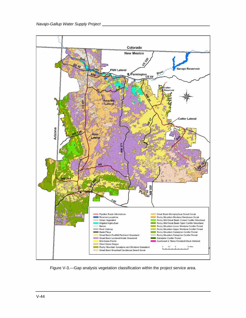
Navajo-Gallup Water Supply Project
V-44
Figure V-3.—Gap analysis vegetation classification within the project service area.
Chapter V – Affected Environment and Environmental Consequences
V-45
tamarisk are dominant species within 98 feet of the San Juan River (37 and 30 percent of total vegetation, respectively) (Bliesner and Lamarra, 2000). Fremont cottonwood (Populus fremontii) occurs infrequently (7 percent) and reaches its highest density above RM 155. Native willows are common below RM 130. These riparian areas support a greater diversity of both vegetation and wildlife than the surrounding upland areas. Wetlands.—The U.S. Army Corps of Engineers (Federal Register, 1982) and the EPA (Federal Register, 1980) jointly define wetlands as those areas that are inundated or saturated by surface or groundwater at a frequency and duration sufficient to support, and that under normal circumstances do support, a prevalence of vegetation typically adapted for life in saturated soil conditions. Wetlands generally include swamps, marshes, bogs, and similar areas. Wetlands within the proposed project area are generally associated with the San Juan River, Cutter Reservoir, intermittent streams and arroyos, or irrigation. Special Status Plants.—Plant species of concern include two federally endangered and two federally threatened species as well as seven Federal species of concern. The Navajo Nation considers 13 plants as endangered. Plant species of concern are discussed within the “Special Status Species” section of this chapter. Vegetation Resources – Methodology This section describes the methods used to measure the effects of the No Action, SJRPNM, and NIIP Amarillo Alternatives. The significance of such effects is evaluated based on the impact indicators outlined in the overview. Twenty vegetation classifications were identified by the New Mexico Natural Heritage Program (NMNHP) and Arizona Natural Heritage Program within the proposed project area (attachment K). A GIS was used to quantify each of the habitat classification types within 500 feet of the SJRPNM and NIIP Amarillo pipeline routes. The gap analysis13 data have a 98-foot resolution, such that areas of habitat smaller than 98 feet may not be included in this analysis. Specific vegetation classifications developed by the NMNHP (Muldavin et al., 1996) were used to classify vegetation within the 500 feet of the proposed pipeline routes. Gap analysis data were used to quantify plant communities in accordance with the NMNHP classifications. The 1,000-foot pipeline corridor represents the areas of vegetation
13 A comparison of the distribution of elements of biodiversity with that of areas managed for their long-term viability to identify elements with inadequate representation.
Navajo-Gallup Water Supply Project
V-46
potentially disturbed during placement of the pipeline and accessory features. The estimate is conservative, and in most cases, a smaller area of vegetation will be affected. Design drawings were used to enumerate the area of vegetation permanently removed for water development structures and to consider the extent and location of vegetation (volume II, appendix B). The same methods were used to evaluate project effects on wetland and riparian vegetation. Site visits were used to describe the general nature of riparian vegetation. Wetland delineations were conducted to identify and describe wetlands that may be affected during construction of the action alternatives. Potentially affected wetlands were identified and mapped to provide pertinent information to determine jurisdictional and permitting requirements under section 404 of the CWA. Wetland delineations targeted the north side of the San Juan River immediately east of the PNM diversion dam and the outlet and base of Cutter Dam (ESRI, 2005). Vegetation Resources – Impacts Analysis This section describes the effects of the No Action, SJRPNM, and NIIP Alternatives on vegetation within the proposed project area. Mitigation measures are described and the net effects of each alternative, following mitigation, are evaluated. The significance of each effect is determined based on the impact indicators presented in the overview. No Action Alternative.—Water conservation may alter urban landscaping and agricultural uses, and changes in irrigation water use could reduce wetlands associated with irrigation. SJRPNM Alternative.—Under the SJRPNM Alternative, up to 31,686 acres of vegetation may be temporarily disturbed (table V-7) during construction of project facilities. The largest components of vegetation include 10,057 acres of Great Basin foothill-piedmont grassland, 8,290 acres of Great Basin lowland/swale grassland, and 7,477 acres of Great Basin microphyllous desert scrub. Impacts to vegetation would be less than 0.01 percent for each of the 12 vegetation classification types affected. Up to 43 acres of vegetation would be removed for placement of a river pumping plant, 2 water treatment facilities, 17 forebay tanks and pumping plants, 4 regulating tanks, and 20 community storage tanks. Twenty-six acres of vegetation removed for placement of permanent project features would be native upland vegetation. Seventeen acres of exotic riparian vegetation occur within 500 feet of the proposed alignment. Riparian vegetation in this area is composed primarily of Russian olive and tamarisk (ESRI, 2002). A limited amount of this vegetation may be disturbed during

Chapter V – Affected Environment and Environmental Consequences
V-47
Table V-7.—Acres of affected vegetation within the proposed project area
Total project area
Affected by SJRPNM Alternative
Affected by NIIP Amarillo Alternative
Vegetation classification type Acres Acres Percent Acres Percent
Barren 156,356 761 0.0049 7,560 0.0048
Great Basin broadleaf deciduous desert scrub 466,412 1,270 0.0027 1,399 0.0030
Great Basin foothill-piedmont grassland 1,124,489 10,507 0.0093 10,586 0.0094
Great Basin lowland swale grassland 1,481,846 8,290 0.0056 8,518 0.0057
Great Basin microphyllous desert scrub 852,050 7,477 0.0088 8,518 0.0100
Irrigated agriculture 50,926 124 0.0024 109 0.0021
Riverine/lacustrine 10,037 42 0.0042 0 0
Rocky Mountain/Great Basin open conifer woodland
527,845 1,371 0.0026 1,371 0.0026
Rocky Mountain montane deciduous scrub 3,148 121 0.0384 121 0.0384
Short grass steppe 124,028 1,065 0.0086 1,065 0.0086
Urban vegetated 8,827 657 0.0744 657 0.0744
Total acres of vegetation classified within the proposed project area
4,668,243 31,686 0.0063 31,841 0.0063
construction. The SJRPNM Alternative would remove 18 acres of vegetation in the immediate vicinity of the San Juan River for pumping and water treatment facilities. A small area (0.09 acre) of non-native shrub cover would be removed to place the pump. The remaining acres are fallow agricultural land and would be removed for the water treatment facilities. However, releases made from Navajo Reservoir to meet project demands may help maintain existing riparian vegetation downstream of Navajo Dam to the PNM diversion structure. Wetland delineations identified three separate wetlands within the San Juan River site: (1) 12.86 acres of palustrine shrub-scrub wetland, (2) 11.39 acres of persistent emergent palustrine wetland, and (3) 1.54 acres of persistent, palustrine emergent wetland. In addition, wetland delineations below Cutter Dam identified two persistent, palustrine emergent wetlands totaling 0.51 acre. Under the SJRPNM Alternative, 3.6 acres would be temporarily disturbed and 1.1 acres of palustrine wetlands would be permanently removed during the construction of project features. Wetlands permanently removed include 1.0 acre along the San Juan River and 0.1 acre below Cutter Dam. Other waters of the United States that are protected under the CWA occur within and adjacent to the proposed project boundaries. These include the San Juan River and Cutter Reservoir adjacent to the wetland sites discussed above. Potential jurisdictional wetlands and/or other waters of the United States associated with crossing of intermittent streams
Navajo-Gallup Water Supply Project
V-48
may occur along the proposed SJRPNM Alternative’s pipeline route. The boundaries of these sites will be determined based on the presence of wetland vegetation, the ordinary high water mark as distinguished by a lack of terrestrial vegetation, and/or the accumulation of litter and debris on the shore. Mitigation measures described below in the following “Vegetation Resources – Mitigation Measures” section could reduce impacts associated with pipeline construction and replace riparian and wetland habitats lost or impacted during the construction of project facilities. NIIP Amarillo Alternative.—Under the NIIP Amarillo Alternative, up to 31,484 acres of vegetation may be disturbed. The largest component of vegetation includes 10,586 acres of Great Basin foothill-piedmont grassland, 8,518 acres of Great Basin lowland/swale grassland, and 7,260 acres of Great Basin microphyllous desert scrub (see table V-7). Impacts to vegetation would be less than 0.01 percent for each of the 12 vegetation classification types affected. In addition, a total of 249 acres of vegetation would be removed for placement of 2 water treatment facilities, 17 forebay tanks and pumping plants, 6 regulating tanks, 20 community storage tanks, and one 226-acre holding pond. No riparian cover types were detected within one-half mile of the proposed NIIP Amarillo alignment; therefore, the NIIP Amarillo alignment is predicted to have no effect on existing riparian vegetation. There would be no benefit to riparian habitat downstream of Navajo Reservoir as described in the SJRPNM Alternative because all project demands would be delivered through the existing NIIP system with no additional releases downstream of Navajo Dam. Wetland impacts would be limited to 0.1 acre permanently removed for project facilities below Cutter Dam. Other waters of the United States that are protected under the CWA occur within and adjacent to the proposed project boundaries, including Cutter Reservoir adjacent to the wetland sites discussed above. Potential jurisdictional wetlands and/or other waters of the United States associated with crossing of intermittent streams may occur along the proposed NIIP Amarillo Alternative’s pipeline route. The boundaries of these sites will be determined based on the presence of wetland vegetation, the ordinary high water mark as distinguished by a lack of terrestrial vegetation, and/or the accumulation of litter and debris on the shore. Mitigation measures would be similar to those described under the SJRPNM Alternative. Vegetation Resources – Mitigation Measures General mitigation procedures could include:

Chapter V – Affected Environment and Environmental Consequences
V-49
Upland Sites
• Use accepted erosion control measures during construction
• Minimize pipeline and accessory components’ footprints
• Seed disturbed areas with a mixture of local-source, native grasses
• Supplement grass seeding with native shrub seeds in areas where shrub cover is diminished due to pipeline disturbance
• Monitor plantings to ensure establishment of native cover equivalent to pre-
construction disturbance levels
• Control noxious weeds in disturbed areas (i.e., herbicide applications) Riparian and Wetland Sites
• Replant disturbed areas with native riparian/wetland shrubs, including coyote willow (Salix exigua) immediately following construction
• Clear tamarisk and Russian olive within 300 feet of project features and replant
such areas with native riparian shrubs
• Monitor plantings to ensure establishment of native cover equivalent to pre-construction disturbance levels
• Replace removed riparian and wetland habitat with creation of acre-per-acre
replacement or the enhancement of 3 acres for each acre lost. The CWA has statutory requirements that require mitigation for impacts to jurisdictional wetlands. In addition, Executive Order 11990 requires Federal agencies to “. . .take action to minimize the destruction, loss or degradation of wetlands, and to preserve and enhance the natural and beneficial values of wetlands in carrying out the agency’s responsibilities for (1) acquiring, managing, and disposing of Federal lands and facilities; (2) providing federally undertaken, financed, or assisted construction and improvements; and (3) conducting Federal activities and programs affecting land use, including but not limited to water and related land resources planning, regulating, and licensing activities.”

Navajo-Gallup Water Supply Project
V-50
Vegetation Resources – Summary of Impacts Under the No Action Alternative, water conservation may alter urban landscaping and agricultural uses, and changes in irrigation water use could reduce wetlands associated with irrigation. Construction of the SJRPNM Alternative would temporarily remove up to 31,686 acres of vegetation for pipeline construction assuming up to a 500-foot disturbance area on either side of the pipeline. Of the vegetation temporarily removed, 17 acres of exotic Russian olive and tamarisk would be replaced with native riparian vegetation within the San Juan River corridor. In addition, 3.6 acres of wetlands within the San Juan River corridor would be temporarily impacted during pipeline construction. Native grasses and shrubs comprise the largest vegetation resource affected. Approximately 43 acres would be permanently removed for project features under the SJRPNM Alternative, including 0.09 acre of riparian shrub vegetation and 1.1 acres of wetland vegetation. Revegetation and restoration of upland areas and habitat enhancement in riparian zones would minimize project effects. Construction of the NIIP Amarillo Alternative would disturb up to 31,841 acres of vegetation. In addition, 249 acres would be permanently removed for project features, including 1.1 acres of wetland vegetation. Riparian vegetation would not be impacted during construction activities. Implementation of mitigation measures to revegetate and restore upland areas, enhance habitat in riparian zones, and provide compensatory wetland mitigation as proposed would minimize project effects.
Wildlife Resources This section addresses the present status of, and project-related impacts to, wildlife resources in the proposed project area. Issue: How would the No Action, SJRPNM, and NIIP Amarillo Alternatives affect
wildlife resources?
O v e r v i e w
Scope
The scope of this analysis includes terrestrial wildlife resources found within one-half mile of the SJRPNM and NIIP Amarillo proposed pipeline alignments
Chapter V – Affected Environment and Environmental Consequences
V-51
and all wildlife habitat found within 500 feet of these alignments. Fisheries and aquatic wildlife are discussed in the “Aquatic Resources” section of this chapter. Federal and Navajo Nation listed and candidate species are discussed in the “Special Status Species” section of this chapter.
Impact Indicators
Defined standards, determined by government regulatory agencies and accepted professional opinion, provide the necessary criteria to assess potential impact significance on aquatic resources for the proposed project. In accordance with these standards, potential outcomes in this analysis were considered significant if they resulted in the following:
(1) Substantially diminished habitat for wildlife
(2) A deterioration of existing wildlife habitat
(3) A permanent loss of key wildlife habitat (e.g., wintering grounds,
wetlands) (4) Disturbance to wildlife key critical stages (e.g., nesting, breeding)
Wildlife Resources – Affected Environment This section describes wildlife habitat and common wildlife species that may be affected by the SJRPNM and NIIP Amarillo Alternatives. Descriptions include common wildlife and habitat within 500 feet of the proposed pipeline alignments. Federal and Navajo Nation threatened, endangered, candidate, and species of concern are discussed in the “Special Status Species” section of this chapter. Wildlife Habitat.—Wildlife habitat can be broken into three main categories in the proposed project area: (1) bottomland riparian/wetland habitat, (2) irrigated agriculture and urban habitat, and (3) arid upland habitat. Wildlife investigations conducted in 1983 (Reclamation, 1983) within a portion of the proposed project area and gap analysis data show that habitat within the 1983 study area and the proposed project area are proportioned similarly. A list of wildlife species and habitat associations that may occur in the proposed project area is presented in attachment L. Bottomland, riparian, and wetland habitat within the proposed project area include the San Juan River and Chaco Rivers and numerous arroyos. Both cover and forage are provided by this habitat for the following:

Navajo-Gallup Water Supply Project
V-52
• Nine of the 11 amphibian species found in the area depend on this habitat.
• Fifteen of the 34 reptile species found in the proposed project area use bottomlands, and 3 use these habitat types exclusively (Reclamation, 1983).
• A broad variety of birds use riparian habitat as wintering, resting, and nesting
areas (these bottomland areas are considered essential to maintaining avian diversity in the area).
• Large and small mammals and reptiles also rely on these types of habitat.
Over one-half of the 84 mammals found in the proposed project area use riparian/wetland habitat (Reclamation, 1983).
Irrigated agriculture and urban habitat provide important wildlife habitat in the arid project landscape. These habitat types are located along the San Juan River corridor as well as in and around the NIIP near Farmington, New Mexico. The interspersion of crops, fencerows, ditchbanks, orchards, and plentiful water create high-value wildlife habitat. The highest abundance of birds in the proposed project area is found within agricultural fencerow habitat. Large and small mammals, birds, amphibians, and reptiles use these habitat types. Vegetation and associated wildlife are sparse within the upland habitat due to low precipitation and extensive grazing. According to a 1981 report by the Service, “In certain areas there is virtually no vegetation. Most of these lands are open to livestock grazing, primarily sheep. The heavy grazing pressure along with the lack of regular water supply greatly limits both the plant and wildlife diversity.” Of 105 avian species commonly found in the proposed project area, 43 were associated with upland grass habitat (Reclamation, 1983). Of the 50 mammal species using upland habitat, 4 were exclusively associated with arid shrub/grassland habitat. Amphibians and reptiles show the same trend, with 5 species linked to grassland/shrub communities out of the 45 species potentially present in the proposed project area. Common Wildlife Species.—Eighty-four mammal, 11 amphibian, 34 reptile, and 150 avian species have been recorded within habitat types that occur within the proposed project area (attachment K; Reclamation, 1983). Recent information on wildlife in the proposed project vicinity is limited to censuses of elk and mule deer. Mid-winter 2002 aerial surveys of State lands in Game Management Unit 7 adjacent to the Navajo Nation estimate four elk per square mile and fewer than one mule deer per square mile in (the western and central portion) of the proposed project. Estimates in Game Management Unit 2B (northeastern portion of San Juan County, New Mexico) include approximately 5,100 deer and 1,350 elk (ESRI, 2003a).

Chapter V – Affected Environment and Environmental Consequences
V-53
San Juan and McKinley Counties in New Mexico exhibit relatively high trapping rates for fur-bearing mammals including coyote, gray fox, bobcat, red fox, kit fox, badger, raccoon, ringtail, spotted skunk, striped skunk, weasel, muskrat, and beaver. Trapping records show a declining trend for kit fox and muskrat and an increasing trend for bobcat (New Mexico Department of Game and Fish [NMDGF], 2000). Common species observed during field surveys included Gunnison’s prairie dog, kangaroo rat, deer mice, chipmunk, coyote, badger, bobcat, red-tailed hawk, ferruginous hawk, packrat, red fox, and golden eagle (ESRI, 2002). Ferruginous hawk and golden eagle are Navajo Nation listed species and discussed in greater detail in the “Special Status Species” section of this chapter. Wildlife Resources – Methodology This section describes the methods used to measure the effects of the SJRPNM and NIIP Amarillo Alternatives relative to the No Action Alternative. The significance of such effects is evaluated based on the impact indicators outline in the overview. Reports from the NMDGF, Navajo Department of Fish and Wildlife, the Service, Bureau of Land Management (BLM), and Reclamation were reviewed to compile a description of wildlife in the proposed project area. In addition, field surveys were conducted on approximately 290 miles of the proposed pipeline alignments. The route was walked in increments along the centerline and wildlife observations made to both sides. Binoculars and close visual inspections were used throughout the survey. Sandstone cliffs, large trees, and utility structures within one-quarter mile of the proposed routes were visually inspected for raptor nests, and perching and roosting sites. Both direct sightings and indirect evidence (tracks, droppings, burrows, and others) were used to document wildlife presence in the proposed project area (ESRI, 2003a). Wildlife Resources – Impacts Analysis This section describes the effects of the No Action, SJRPNM, and NIIP Amarillo Alternatives on wildlife within the proposed project area. Implementation of the SJRPNM or NIIP Amarillo Alternatives would alter or remove areas of wildlife habitat. In addition, construction activities might disturb animals using the proposed project area. Maintenance of project facilities might create long-term disturbance, and powerlines associated with pumping plants and project facilities might pose a hazard to raptors and other birds. No Action Alternative.—The No Action Alternative would have no effect on wildlife habitat or wildlife resources within the proposed project area. The proposed project would not be constructed and no ground-disturbing activities would impact wildlife habitat or wildlife resources.

Navajo-Gallup Water Supply Project
V-54
SJRPNM Alternative.—Temporary disturbance during construction may be the largest impact to wildlife under the SJRPNM Alternative. Because many desert species are nocturnal, direct interaction may not occur. However, small mammal and reptile burrows may be disturbed and their occupants dispersed during construction. Interference during the nesting season may cause nest failures for birds along the pipeline routes. Long-term disturbance to wildlife from maintenance activities would be minimal because the pipeline route mainly follows existing roads. Therefore, wildlife should be habituated to human presence in these areas. The SJRPNM Alternative would temporarily disturb up to 31,686 acres of wildlife habitat. Key habitat within this alignment includes: (1) potential raptor nesting along the Defiance Monocline near Window Rock, Arizona; (2) raptor nesting along the Nutria Monocline northeast of Gallup, New Mexico; (3) raptor hunting areas southwest of Nageezi, New Mexico, and east of Sheep Springs, New Mexico; (4) riparian vegetation and wetlands along the San Juan River; and (5) raptor nesting areas in Blanco and Cutter Canyons. Because project construction is proposed in phases (possibly a 10-year period or more) and the pipeline corridors are proposed to be revegetated concurrently with construction, wildlife habitat loss would be minimal. Key habitat that would temporarily be removed during pipeline construction consists of 17 acres of riparian habitat and 3.6 acres of wetlands. In addition, 3.26 acres of raptor cliff nesting habitat may be impacted. The riparian habitat, composed primarily of exotic Russian olive and tamarisk, could be revegetated with native riparian species. Following vegetation restoration, increased riparian wildlife habitat value is anticipated. Other project features would permanently displace approximately 43 acres of habitat and result in the loss of 1.19 acres within key wildlife habitat. Construction of the water treatment facility and river pump along the San Juan River would result in the permanent loss of 1.9 acres of key habitat (0.09 acre of riparian shrub and 1.0 acre of wetland habitat). An additional 0.1 acres of wetlands would be permanently removed for construction of the Cutter water treatment plant. Power transmission lines and substations pose an additional threat to birds in the proposed project area. Hazards associated with powerlines include the risk of electrocution to perching raptors and a risk of avian collision. The SJRPNM Alternative includes approximately 107 miles of transmission line. The barren nature of the proposed project area creates a relatively high electrocution risk to raptors, as they may select utility structures from which to perch and hunt. Electrocution occurs when two or more conductors are contacted simultaneously. Thus, large-winged raptors are at greater risk than smaller birds (Bevanger, 1994).

Chapter V – Affected Environment and Environmental Consequences
V-55
Project effects on small mammals and reptiles would be temporary, but should not be significant because the effects would be temporary, and suitable habitat is available outside disturbed areas. Large, mobile animals may avoid areas during construction, but these impacts would be temporary. San Juan River habitat is used for both nesting and migration for many bird species. Restricting San Juan River pipeline crossing construction activities to low flow periods would provide adequate protection to nesting birds along the San Juan River. Adjacent areas for project facilities (siltation ponds and pumping plants) would occur in disturbed areas with non-native vegetation. In addition, these features would be adjacent to the PNM diversion dam and near the highway where existing wildlife have become habituated to these disturbances. Construction and maintenance activities along river habitat may disturb wildlife during critical periods; however, this is not considered a significant impact. Implementation of proposed mitigation measures would minimize or avoid impacts to wildlife. NIIP Amarillo Alternative.—The NIIP Amarillo Alternative would temporarily disturb up to 31,841 acres of wildlife habitat. Project structures would permanently displace up to 249 acres of upland habitat. In addition, 0.1 acre of wetlands considered to be a key wildlife habitat would be removed. Under the NIIP Amarillo Alternative, no riparian habitats would be affected. Other disturbances to wildlife would be similar to those caused by the SJRPNM Alternative; however, additional upland habitat would be inundated for the storage reservoir. Implementation of proposed mitigation measures would minimize or avoid impacts to wildlife. Wildlife Resources – Mitigation Measures The following proposed mitigation measures would minimize project effects on wildlife. Habitat disturbance caused by the placement of pipeline would be temporary because of the restoration planned for disturbed vegetation.
• To minimize disturbance of raptors, activities along the Nutria and Defiance Monoclines, Cutter Canyon, Blanco Canyon, and the corridor from Cutter to Largo Canyons could be restricted during the nesting season (January 15 to July 15). If that is not possible, extensive nest searches could be made up to three-quarters of a mile of proposed activities immediately prior to construction and active nests avoided. Raptor perch guards or raptor-safe configurations could be incorporated for all transmission structures.

Navajo-Gallup Water Supply Project
V-56
• Transmission lines that pose a high collision risk could be marked with spiral vibration dampers or bird flight diverters.
• To comply with the Migratory Bird Treaty Act, removal of riparian and wetland
vegetation that has the potential to impact nesting birds or active nests would be restricted from March 15 to August 15.
• Construction of the pipeline river crossing could be restricted to low water periods
to minimize construction dewatering costs and to reduce potential risks of flooding. This restriction would prevent construction within the San Juan River during the normal nesting season for most migratory bird species that occur along the San Juan River.
• Trenching and burying pipeline concurrently could be implemented to minimize
trapping of small wildlife. Escape ramps could also be built for trenches left open overnight.
• The mitigation measures proposed in the “Vegetation Resources” section of this
chapter could also minimize impacts to wildlife. Wildlife Resources – Summary of Impacts Temporary disturbance during construction would be the largest impact to wildlife under the action alternatives. The alternatives could temporarily disturb large areas of wildlife habitat (31,686 acres,—SJRPNM and 31,841 acres—NIIP Amarillo) during pipeline construction. Construction of project facilities would result in the permanent loss of wildlife habitat (43 acres—SJRPNM and 249 acres—NIIP Amarillo). Temporary impacts to key habitat would occur under both alternatives (23.86 acres—SJRPNM and 3.26 acres—NIIP Amarillo). Permanent loss of key habitats would occur under both alternatives (1.19 acres—SJRPNM and 0.1 acre—NIIP Amarillo). Both action alternatives would construct 19.2 miles of pipeline through raptor cliff nesting habitat and could temporarily affect 3.26 acres within raptor cliff nesting habitat. The 19.2 acres of transmission line also may pose an avian collision risk. Implementation of proposed mitigation measures could minimize or avoid impacts to wildlife and wildlife habitat.
Aquatic Resources This section addresses the present status of and project-related impacts to aquatic resources in the proposed project area, including fish inhabiting both Navajo Reservoir and those downstream of the dam in the San Juan River to Lake Powell.

Chapter V – Affected Environment and Environmental Consequences
V-57
Issue: How do changes in reservoir levels affect the reservoir fishery, and how do changes in flow regimes affect the downstream aquatic ecosystem?
O v e r v i e w
Scope
Non-native (game and nongame fish) and native fish and other aquatic wildlife in both Navajo Reservoir and in the San Juan River from Navajo Dam to Lake Powell. Threatened and endangered species are discussed in the “Special Status Species” section of this chapter.
Impact Indicators
Potential outcomes in this analysis were considered significant if they resulted in:
(1) Adverse effects on hydrology in the San Juan River
(2) An undesirable change in the composition of the native fish community.
(3) Deterioration of trout habitat from Navajo Dam to Blanco, New Mexico (4) An undesirable change in the composition of the Navajo Reservoir fish
community.
Aquatic Resources – Affected Environment This section describes fish, amphibians, and macroinvertebrates associated with Navajo Reservoir and the San Juan River downstream of Navajo Dam. Characteristics of the river environment are included. Table V-8 shows the fisheries resources that occur in Navajo Reservoir and the San Juan River from Navajo Dam downstream to Lake Powell. Navajo Reservoir.—Navajo Reservoir began filling in 1963 with the completion of Navajo Dam. The reservoir extends 35 miles up the San Juan River, 13 miles up the Pine River, and 4 miles up the Piedra River. It has a maximum surface area of 15,610 acres and a storage capacity of 1,709,000 acre-feet (Reclamation, 2006). Releases from the reservoir maintain target flow levels for endangered fish in the San Juan River and support a tailwater trout fishery. In addition, the reservoir provides recreation opportunities, including angling for northern pike, catfish, smallmouth bass, rainbow trout, and kokanee salmon (Reclamation, 2006).

Navajo-Gallup Water Supply Project
V-58
Table V-8.—Fishes documented in the Basin Documented occurrence
Common name Scientific name Navajo
Reservoir San Juan
River
Native
Bluehead sucker Catostomus discobolus Yes Yes Colorado pikeminnow Ptychocheilus lucius No Yes Flannelmouth sucker Catostomus latipinnis Yes Yes Razorback sucker Xyrauchen texanus No Yes Roundtail chub Gila robusta Yes Yes Mottled sculpin Cottus bairdi No Yes Speckled dace Rhinichthys osculus No Yes
Non-native
Black bullhead Ictalurus melas Yes Yes Black crappie Pomoxis negromaculatus Yes No Bluegill Lepomis macrochirus Yes Yes Brown trout Salmo trutta Yes Yes Channel catfish Ictalurus punctatus Yes Yes Common carp Cyprinus carpio Yes Yes Fathead minnow Pimephales promelas No Yes Grass carp Ctenopharyngodon idella No Yes Green sunfish Lepomis cyanellus Yes Yes Kokanee salmon Onchorhynchus nerka Yes No Largemouth bass Micropterus salmoides Yes Yes Western mosquitofish Gambusia afinnis No Yes Northern pike Esox lucius Yes No Plains killifish Fundulus zebrinnus No Yes Rainbow trout Onchoryhnchus mykiss Yes Yes Red shiner Cyprinella lutrensis No Yes Smallmouth bass Micropterus dolomieu Yes Yes Striped bass1 Morone saxatilis No Yes Threadfin shad Dorosoma petenense Yes Walleye1 Stizostedion vitreum No Yes White sucker Catostomus commersoni Yes Yes Yellow perch Perca flavescens Yes No
Hybrid
Bluehead x flannelmouth Catostomus discobolus x latipinnis
No Yes
White sucker x bluehead Catostomus commersoni x discobolus
No Yes
White sucker x flannelmouth Catostomus commersoni x latipinnis
No Yes
1 Found in the lower reach of the San Juan River near Lake Powell.

Chapter V – Affected Environment and Environmental Consequences
V-59
San Juan River.—The San Juan River originates in the San Juan Mountains of southwestern Colorado. Its course extends south into New Mexico and then turns west to its confluence with Lake Powell in Utah. Along its 354-mile length, the San Juan River drains 38,300 square miles in Colorado, Arizona, New Mexico, and Utah. Since the closure of Glen Canyon Dam, the lower 54 miles of the San Juan River have been inundated by Lake Powell. Currently, there are 223 miles of river between Navajo Dam and Lake Powell. Prior to the completion of Navajo Dam, the San Juan River showed an extremely variable hydrograph characterized by peak spring flows associated with snowmelt and by low summer and winter base flows; late summer and fall storms caused dramatic spikes in flow. Over the period of record (1929–61), unregulated median daily peak flows averaged 10,500 cfs at Bluff, Utah (range 3,810–33,800 cfs) during spring runoff, and 73 percent of yearly flows occurred between March 1 and July 31 (Bliesner and Lamarra, 2000). Although spring flows accounted for the majority of discharge, storms often created spikes in the hydrograph larger than those recorded during spring runoff. Such short-duration peaks moved sediment and restructured habitat. In contrast to a maximum daily flow of 42,500 cfs, base flows often approached zero prior to regulation by Navajo Dam. Regulated flows dropped below 50 cfs during 29 percent of the years studied (Bliesner and Lamarra, 2000). Flash flooding from tributaries and erodible soils along the river created high sediment loads. Thus, native vertebrate and invertebrate species within the San Juan River are adapted to high-velocity, turbid conditions. After Navajo Dam was completed, peak flows were created by late winter releases designed to increase available reservoir storage prior to snowmelt. The magnitude of such peaks was reduced relative to pre-dam conditions, whereas base flows increased. Median monthly base flows for August through February averaged 168 percent of original base flows. Near-zero-flow conditions were eliminated, and minimum average monthly flows increased from 65 cfs to 250 cfs (Bliesner and Lamarra, 2000). Since 1991, Navajo Dam has been operated to more closely mimic the San Juan River’s natural hydrograph (Holden, 1999). This reoperation is designed to improve habitat and conditions for federally protected fish. Peak flows are timed to coincide with those from the Animas River during spring runoff. The magnitude of flows is based on snowpack. Various flow parameters are set to mimic natural variability in the system (Holden, 1999) as described in the Flow Recommendations. The San Juan River between Navajo Dam and Lake Powell has been partitioned into eight reaches based on geomorphology and other channel characteristics. A brief description of each reach, taken from Bliesner and Lamarra (2000), is shown in figure V-4 and presented below.
• Reach 1 (RM 0 to 16) is a low-gradient, sand-bottomed reach created by backwater from Lake Powell.

Navajo-Gallup Water Supply Project
V-60
Figure V-4.—San Juan RM locations.

Chapter V – Affected Environment and Environmental Consequences
V-61
• Reach 2 (RM 17 to 67) is canyon-bound but is located above the influence of Lake Powell, with higher gradient, dominated by riffle-type habitat.
• Reach 3 (RM 68 to 105) is characterized by higher sinuosity and lower gradient
(second lowest) than the other reaches, a broad flood plain, multiple channels, high island count, and high percentage of sand substrate. Backwaters are more abundant, but are easily perturbed by summer stormflows.
• Reach 4 (RM 106 to 130) is a transition reach between the upper cobble-
dominated reaches and the lower sand-dominated reaches with relatively low abundance of backwaters and little clean cobble.
• Reach 5 (RM 131 to 154) is predominately multichanneled. Backwaters and
spawning bars in this reach are much less subject to perturbation during summer and fall storm events than the lower reaches.
• Reach 6 (RM 155 to 180) is predominately a single channel. Cobble and gravel
substrates dominate, and cobble bars with clean interstitial space are more abundant in this reach than in any other. Four diversion dams limit upstream movement of fish.
• Reach 7 (RM 181 to 213) is similar to Reach 6 in terms of channel morphology.
The river channel is very stable, consisting primarily of embedded cobble substrate as a result of controlled releases from Navajo Dam, and much of the river bank has been stabilized and/or diked.
• Reach 8 (RM 214 to 224) is the most directly influenced by Navajo Dam, which
is situated at its uppermost end (RM 224). This reach is predominately a single channel with cobble substrate and clean, cold water as a result of Navajo Dam.
Along with streamflow, channel morphology and geology are the primary factors influencing aquatic habitat. Unless otherwise noted, the following information on channel morphology, geology, and riparian habitat is taken from analyses conducted by Bliesner and Lamarra (2000). The San Juan River valley ranges from less than 655 feet to more than 2 miles across. After an initial canyon-bound reach below Navajo Dam, the river valley widens beyond RM 208 to over 1.86 miles across near Shiprock, New Mexico. From there, the river valley narrows to a width of about 3,280 feet until it becomes canyon-bound below RM 68. The San Juan River reaches its maximum gradient near RM 18. The slope generally decreases to RM 140 and then steepens from RM 68 as it enters the canyon. Channel sinuosity is lowest in the canyon reaches and highest in the reach immediately below Navajo Dam. Sinuosity values range from 1.000 to 1.195. The river channel appears most stable between RM 119 and RM 135 based on the area of cutbanks along

Navajo-Gallup Water Supply Project
V-62
both sides. Sand is the primary source material found in cutbanks along the river (64 percent), with cobble and gravel also common (22 and 14 percent, respectively). Riparian vegetation within 98 feet of the channel is dominated by non-native Russian olive (37 percent) and tamarisk (30 percent). Cottonwood (7 percent) and willow (6 percent) are also present. From Navajo Dam to Lake Powell, runs are the most common aquatic habitat at low, medium, and high flows (80 to 84 percent total wetted area). Riffles and shoals are the second most common habitat (3 to 9 percent total wetted area depending on flows) except during high flows when inundated vegetation becomes a common habitat (5.6 percent total wetted area) (Bliesner and Lamarra, 2000). Low-velocity habitat makes up a small portion of the total wetted area (approximately 3.5 percent), and backwaters comprise less than 1 percent of the wetted area. Aquatic Invertebrate Community.—The aquatic invertebrate community is comparatively simple with the majority of the biomass composed of caddisflies, bloodworms, midges, and gnats (Hydropsyche species and Chironomidae). These species are indicative of sediment-laden river systems. The San Juan River reaches its highest productivity in upstream Reaches 6, 7, and 8 (Bliesner and Lamarra, 2000). The lowest densities of aquatic macroinvertebrates are found in Reach 2. Fish.—The San Juan River fish community is characterized as highly endemic with species adapted to harsh, turbid conditions. Twenty-six fish species are found in the San Juan River, including 7 native, 22 non-native, and 3 hybrid (Ryden, 2000a). However, six of these species—three native and three introduced—comprise 99 percent of the fish found in the river. The most abundant native fish include the flannelmouth sucker (Catostomus latipinnis), bluehead sucker (Catostomus discobolus), and speckled dace (Rhinichthys osculus). Abundant non-native fish include the channel catfish (Ictalurus punctatus), common carp (Cyprinus carpio), and red shiner (Richardsonius balteatus). Roundtail chub (Gila robusta) collected in the San Juan River appear to be from resident populations in the Animas, La Plata, and Mancos Rivers and do not seem to be established within the main stem of the San Juan River. In general, the density of native fish species increases upstream to near Farmington, New Mexico (RM 180). This longitudinal increase in density is driven primarily by flannelmouth and bluehead suckers, which exhibit high abundances in Reaches 5 and 6 (Ryden, 2000a). Above RM 180, hypolimnetic releases from Navajo Dam cool the San Juan River and favor an introduced trout fishery. Beginning in 1995, walleye, striped bass, and threadfin shad (non-native fish species) were accidentally introduced to the San Juan River fish community when a waterfall restricting movement of Lake Powell fishes into the San Juan River at RM 0.0 was inundated (Ryden, 2000a).

Chapter V – Affected Environment and Environmental Consequences
V-63
Threadfin shad remained in the lower reaches of the river, whereas the predacious striped bass and walleye have been collected upstream to RM 91 and 108, respectively (Ryden, 2000a). Native Fishes.— Seven native fish species and one hybrid occur in the San Juan River and make up 74.6 percent of the community as measured by main channel electrofishing (Ryden, 2000a and 2000b). The most abundant native fish is the flannelmouth sucker, followed by the bluehead sucker (58.1 and 12.7 percent, respectively). Two native species are described briefly here. Five rare or endangered native species—Colorado pikeminnow, razorback sucker, roundtail chub, bluehead sucker, and mottled sculpin—are described in more detail in the “Special Status Species” section of this chapter. Emphasis is placed on species distribution and habitat within Reach 6 because this is the area where the withdrawal facilities for the SJRPNM Alternative would be located. Flannelmouth Sucker – The flannelmouth sucker is endemic to the Colorado River system. Flannelmouth sucker prefer pools and low-gradient reaches and are absent from impoundments. These suckers are benthic feeders and consume detritus, algae, periphyton, plants, and insects. They spawn over gravel areas during late spring and early summer. In the San Juan River, the flannelmouth sucker is found in very limited numbers above RM 205 near Blanco, New Mexico, and occur more abundantly downstream of RM 180 near Farmington, New Mexico (Wethington, 2002; Ryden, 2000a). Spawning flannelmouth sucker appear to use cobbles within Reaches 5 and 6 (see figure V-4), although other areas are likely also used (Holden, 1999). Reach 6 has higher numbers of large juvenile and adult fish than the river downstream and is an important spawning area for the flannelmouth sucker (Holden, 1999). The number of large flannelmouth sucker present here may also provide an important prey base for Colorado pikeminnow. Speckled Dace – The speckled dace is found in many drainages west of the Continental Divide. The species reaches its highest abundance in small- to medium-sized rivers and prefers shallow, slow-moving waters. Speckled dace are bottom feeders and consume aquatic insects, plant material, and zooplankton. They broadcast spawn over gravel areas. Speckled dace spawn principally during the spring, but may also spawn during late summer in the San Juan River (Platania et al., 2000). Seine sampling in the San Juan River in low velocity habitat, targeted at small-bodied fish, found speckled dace to be the most common native fish (Propst et al., 2003). Speckled dace are found in very limited numbers upstream of RM 205 near Blanco, New Mexico, where introduced trout are the dominant species (Wethington, 2002). The highest concentrations of speckled dace in the San Juan River occur in Reaches 4, 5, and 6 (figure V-4) and are rare below RM 68 (Ryden, 2000a; Propst et al., 2003). No speckled dace have been caught below RM 13 (Ryden, 2000a).

Navajo-Gallup Water Supply Project
V-64
Non-Native Fishes.—Twenty-one non-native fish species and two hybrid occur in the San Juan River. During main channel electrofishing from Lake Powell to Farmington, New Mexico (RM 3 to RM 180), non-native fish accounted for 25.4 percent of the catch (Ryden, 2000a and 2000b). Thirteen of these non-native species are either known or potential predators of native fish. Dietary overlap among species suggests that non-natives may also place competitive pressure on native San Juan River fish. Furthermore, 12 non-native species are spiny-rayed and may pose a documented choking hazard to Colorado pikeminnow. However, only channel catfish have been documented in Colorado pikeminnow (Ryden, 2000b). Channel catfish, common carp, and red shiner are the most abundant non-native fish. Tailwater Trout Fishery.—Navajo Dam tailwater provides high quality trout habitat with its characterized cobble substrate and the dam’s cool deep water releases. The NMDGF manages the tailwater as a trout fishery from the base of Navajo Dam 17 miles downstream to Blanco, New Mexico. The value of the San Juan trout fishery to the NMDGF is significant, and the long-term management is an important component of the economic and recreational resources of the State of New Mexico (NMDGF, 2008). Annual NMDGF electrofishing surveys from 1997–2001 found an increasing percentage of brown trout in the special trout water and regular regulation reaches. Increases in brown trout numbers may be due to improved spawning success associated with high spring releases from Navajo Dam. The average length of rainbow trout from the special regulation waters was 15 inches, and on average, 18 percent of the rainbow trout were over 18 inches. In contrast, less than 2 percent of trout in the regular regulation waters were over 18 inches; trout in regular regulation waters averaged 9 inches. Since then, NMDGF has managed the effects of whirling disease by stocking only fish 4 inches or larger (Wethington, 2002). The fishery in the lower 10-mile reach is maintained primarily through natural reproduction of brown trout. In 1992, the fish composition within this reach included 62 percent native species (flannelmouth sucker, bluehead sucker, and mottled sculpin). By 1998, this number had declined to less than 1 percent. Higher releases from Navajo Dam associated with the 1991–97 Navajo Dam test flows may be causing this shift (Wethington, 2002). Aquatic Wildlife.—The San Juan River and its associated riparian and marsh habitat support the greatest diversity of wildlife in the proposed project area. Five aquatic mammals known from the proposed project area occur only in the San Juan River and its flood plain—river otter (Lutra Canadensis), beaver (Castor canadensis), meadow vole (Microtus pennsylvanicus), muskrat (Ondatra zibethica), and mink (Mustella vison).
Chapter V – Affected Environment and Environmental Consequences
V-65
Waterfowl are common along the river, and populations have increased since the closure of Navajo Dam and development of the Square-B Ranch near Farmington as a waterfowl and wildlife preserve. Twenty-nine waterfowl species are found in the proposed project area, and 26.5 percent of avian species found in the proposed project area are restricted to breeding in riparian habitat (Reclamation, 1983). Several amphibian species are tied to the San Juan River and tributaries in the proposed project area—tiger salamander (Ambystoma tigrinum), western spadefoot (Scaphiopus hammondi), plains spadefoot (Scaphiopus bombifrons), red-spotted toad (Bufo punctatus), Woodhouse’s toad (Bufo woodhousei), great plains toad (Bufo cognatus), chorus frog (Pseudacris triseriata), bullfrog (Rana catesbeiana), and northern leopard frog (Rana pipiens). Of these, the native northern leopard frog and the introduced bullfrog are found only in habitat within the San Juan River flood plain. The northern leopard frog is discussed in greater detail in the “Special Status Species” section of this chapter. In addition, the smooth green snake (Opheodrys vernalis), common garter snake (Thamnophis sirtalis), and black-necked garter snake (Thamnophis crytopsis) are found only along the river (Reclamation, 1983). Aquatic Resources – Methodology This section describes the methods used to measure the effects of the No Action, SJRPNM, and NIIP Amarillo Alternatives on aquatic resources. The methods are presented here relative to five significance criteria used to assess effects.
(1) Effects on hydrology in the San Juan River
Modeling was used to evaluate effects of alternatives on hydrology in the San Juan River. Keller-Bliesner Engineering, LLC, modeled the No Action, SJRPNM, and NIIP Amarillo Alternatives using RiverWare14 (Bliesner, 2003). The San Juan River Basin Hydrologic Model15 was used as a starting point to configure the proposed project alternatives. Alternatives were modeled from water year 1929 to 1993. All alternatives considered include depletions for the ALP Project. The results of modeling were compared against Flow Recommendation criteria and are discussed in greater detail in the “Special Status Species” section of this chapter.
14 RiverWare is the software that runs the hydrologic model. 15 The San Juan River Basin Hydrologic Model was developed for the SJRBRIP for use in assessing impacts that water development would have on the endangered fish (Flow Recommendations).
Navajo-Gallup Water Supply Project
V-66
(2) An undesirable change in the composition of the native fish community
Effects on the native fish community were approximated based on the effects that each alternative would have on individual species. Bluehead sucker, flannelmouth sucker, and speckled dace were identified as native species vulnerable to entrainment (Platania et al., 2000; Ryden, 2000a). Estimates of entrainment were based on each species’ distribution and the fraction of the flows diverted at the time of peak drift. This analysis assumes that the portion of drifting larvae exiting a reach is directly related to the proportion of a species’ population occupying that reach. This assumption provides a conservative estimate of the fraction of drift originating upstream of the proposed diversion for two reasons. First, a greater proportion of adult and large-sized native suckers are found within Reach 6 (RM 158.6–180) than are found within the downstream reaches (Ryden, 2000a). Adult fish comprise the spawning portion of the population and larger fish show greater fecundity. Thus, fish found in the reach above the proposed intake likely produce more larvae than an equivalent number of fish downstream. Second, abundant clean cobble substrates within Reach 6 provide more suitable spawning habitat than do embedded substrates found within downstream reaches (Bliesner and Lamarra, 2000). Thus, a greater proportion of spawning likely occurs above the proposed diversion. This analysis also assumes that drifting larvae are evenly distributed in the water column. The size parameters used to determine drift for this analysis are from Platania et al. (2000) and refer to individuals with minimal or no control over their longitudinal movement. Such larvae are not sufficiently developed to actively move out of the current and into a low-velocity habitat. Thus, the drifting larvae are likely to be distributed randomly within the water column.
(3) Deterioration of trout habitat from Navajo Dam to Blanco, New Mexico
Effects on the tailrace trout fishery were determined based on hydrology modeling and Reclamation design drawings.
Aquatic Resources – Impacts Analysis This section describes the effects of the No Action, SJRPNM, and NIIP Amarillo Alternatives on aquatic resources. Mitigation plans are described, and each alternative’s net effects are evaluated based on significance criteria.
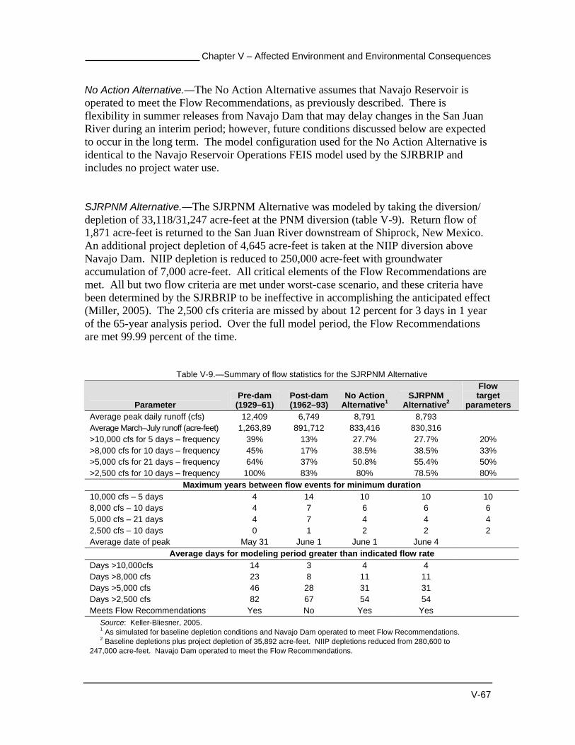
Chapter V – Affected Environment and Environmental Consequences
V-67
No Action Alternative.—The No Action Alternative assumes that Navajo Reservoir is operated to meet the Flow Recommendations, as previously described. There is flexibility in summer releases from Navajo Dam that may delay changes in the San Juan River during an interim period; however, future conditions discussed below are expected to occur in the long term. The model configuration used for the No Action Alternative is identical to the Navajo Reservoir Operations FEIS model used by the SJRBRIP and includes no project water use. SJRPNM Alternative.—The SJRPNM Alternative was modeled by taking the diversion/ depletion of 33,118/31,247 acre-feet at the PNM diversion (table V-9). Return flow of 1,871 acre-feet is returned to the San Juan River downstream of Shiprock, New Mexico. An additional project depletion of 4,645 acre-feet is taken at the NIIP diversion above Navajo Dam. NIIP depletion is reduced to 250,000 acre-feet with groundwater accumulation of 7,000 acre-feet. All critical elements of the Flow Recommendations are met. All but two flow criteria are met under worst-case scenario, and these criteria have been determined by the SJRBRIP to be ineffective in accomplishing the anticipated effect (Miller, 2005). The 2,500 cfs criteria are missed by about 12 percent for 3 days in 1 year of the 65-year analysis period. Over the full model period, the Flow Recommendations are met 99.99 percent of the time.
Table V-9.—Summary of flow statistics for the SJRPNM Alternative
Parameter Pre-dam
(1929–61) Post-dam (1962–93)
No Action Alternative1
SJRPNM Alternative2
Flow target
parameters Average peak daily runoff (cfs) 12,409 6,749 8,791 8,793 Average March–July runoff (acre-feet) 1,263,89 891,712 833,416 830,316 >10,000 cfs for 5 days – frequency 39% 13% 27.7% 27.7% 20% >8,000 cfs for 10 days – frequency 45% 17% 38.5% 38.5% 33% >5,000 cfs for 21 days – frequency 64% 37% 50.8% 55.4% 50% >2,500 cfs for 10 days – frequency 100% 83% 80% 78.5% 80%
Maximum years between flow events for minimum duration 10,000 cfs – 5 days 4 14 10 10 10 8,000 cfs – 10 days 4 7 6 6 6 5,000 cfs – 21 days 4 7 4 4 4 2,500 cfs – 10 days 0 1 2 2 2 Average date of peak May 31 June 1 June 1 June 4
Average days for modeling period greater than indicated flow rate Days >10,000cfs 14 3 4 4 Days >8,000 cfs 23 8 11 11 Days >5,000 cfs 46 28 31 31 Days >2,500 cfs 82 67 54 54 Meets Flow Recommendations Yes No Yes Yes Source: Keller-Bliesner, 2005. 1 As simulated for baseline depletion conditions and Navajo Dam operated to meet Flow Recommendations. 2 Baseline depletions plus project depletion of 35,892 acre-feet. NIIP depletions reduced from 280,600 to 247,000 acre-feet. Navajo Dam operated to meet the Flow Recommendations.

Navajo-Gallup Water Supply Project
V-68
The SJRPNM Alternative would affect aquatic resources by diverting water, disturbing riparian and aquatic invertebrate habitat, and entraining native fish. This alternative would divert 33,118 acre-feet of water from the San Juan River at RM 167 via a pump with an intake of 60 cfs. A portion of this water (1,871 acre-feet) would be returned downstream of Shiprock, New Mexico. An additional 4,645 acre-feet would be diverted from Navajo Reservoir via the existing NIIP facilities to Cutter Reservoir to supply the eastern pipeline. Mean average flows in the river would be increased by 4.6 cfs to meet project demands; minimum flows would decrease by 1.6 cfs, and maximum flows would increase by 25.2 cfs (Bliesner, 2003). The intake pump would be constructed adjacent to the San Juan River, and the pipeline would cross the river. Aquatic invertebrate habitat might be temporarily affected by substrate disturbance associated with construction. Mean reservoir elevations would increase by 1.3 feet under the SJRPNM Alternative, but are predicted to result in no measurable effect on the fish community in Navajo Reservoir. A portion of the native fish population would be vulnerable to entrainment and impingement with intake facilities associated with the SJRPNM Alternative. An estimated 8.3 percent of flannelmouth sucker and 10 percent of speckled dace in the San Juan River are found upstream of the proposed intake structure (Propst et al., 2003). The fraction of these fish subject to entrainment depends on screening and the location of the intake. In the process of recovery, Colorado pikeminnow, razorback sucker, and bluehead sucker may also become entrained within project facilities, as is discussed in the “Special Status Species” section of this chapter. Under the SJRPNM Alternative, the intake pump would be screened at 3/32 inch to minimize fish entrainment. This screen size is already a standard on all Upper Colorado River Basin diversions and is designed to exclude 20–30 millimeter larval fish. To avoid impingement, screens would be designed such that approach velocities do not exceed 0.5 cfs. The SJRPNM Alternative has the potential to affect the composition of the native fish community through entrainment of flannelmouth sucker and speckled dace. Based on electrofishing population estimates from 1991–2002, 8.3 percent of the flannelmouth sucker population is located upstream of the proposed intake. Both native suckers spawn during the late spring and early summer (May–June). Average flows at Farmington during 1993–2003 were 5,011 cfs (USGS, 2003). The proposed SJRPNM Alternative would withdraw 60 cfs or 1.2 percent of San Juan River flows during the period of peak drift. Bluehead sucker exit the drift at 15 millimeters, and flannelmouth sucker exit the drift at 20 millimeters. Thus, all drifting larvae would be vulnerable to entrainment. Based on flows, 1.2 percent of the drift produced upstream of the proposed diversion would be entrained. This amounts to 0.10 percent of flannelmouth sucker larvae produced in the San Juan River between Navajo Dam and Lake Powell (ESRI, 2003b). Based on seine sampling from 1998–2001, 10 percent of the speckled dace population in the San Juan River is located upstream of the proposed intake (Propost et al., 2003).
Chapter V – Affected Environment and Environmental Consequences
V-69
Speckled dace primarily spawn during the late spring and early summer (May–June), although limited, late-season spawning has also been documented on the San Juan River (Platania et al., 2000). Average early summer flows at Farmington during 1993–2002 were 5,011 cfs (USGS, 2003). The proposed SJRPNM intake would withdraw 60 cfs or 1.2 percent of San Juan River flows during the period of peak speckled dace drift. Speckled dace exit the drift at 12 millimeters; thus, all drifting larvae would be vulnerable to entrainment. Based on flows, 1.2 percent of the drift produced upstream of the proposed diversion would be entrained. This amounts to 0.12 percent of the speckled dace larvae produced in the San Juan River between Navajo Dam and Lake Powell (ESRI, 200b). When late-season spawning occurs, a greater portion of these larvae would be entrained because the proposed diversion comprises a greater fraction of flows during the late summer. The entrainment losses of 0.10 percent flannelmouth sucker larvae and 0.12 percent speckled dace larvae under the SJRPNM Alternative are not considered significant and are not predicted to result in significant changes in the native fish community. The SJRPNM Alternative has no foreseeable adverse effects on trout habitat below Navajo Dam. This alternative would not disturb any benthic or riparian habitat within the designated sport fishery. Slight increases in flows associated with project demands are not expected to adversely affect trout and may be beneficial, especially during extreme low-flow conditions. NIIP Amarillo Alternative.—The NIIP Amarillo Alternative was modeled by taking a diversion/depletion of 37,763/35,892 acre-feet at the NIIP diversion on Navajo Reservoir. Flows of 1,871 acre-feet would be returned downstream of Shiprock, New Mexico. The NIIP depletion was reduced to 242,000 acre-feet to ensure that the Flow Recommendations are satisfied. An additional 6,300 acre-feet of NIIP groundwater accumulation was included. The NIIP Amarillo Alternative would impact the Flow Recommendations more than the SJRPNM Alternative. Less water would be available in Navajo Reservoir to meet the Flow Recommendations because all project water would come from Navajo Reservoir.
The NIIP Amarillo Alternative includes no new intake structures and poses no entrainment risk to native fish. Changes in flow and mean reservoir elevation (0.9-foot increase) would be imperceptible and would not be expected to affect aquatic conditions or result in changes in the composition of the native fish community or the fish community in Navajo Reservoir. The NIIP Amarillo Alternative when compared to the No Action Alternative would have no measurable effect on the native fish community or trout habitat below Navajo Dam. This alternative is not predicted to disturb trout, aquatic invertebrates, or aquatic habitat on the San Juan River, although slight decreases in flows may occur.

Navajo-Gallup Water Supply Project
V-70
Aquatic Resources – Mitigation Measures No mitigation measures are proposed for aquatic resources. Screening the PNM intake pump and implementation of BMPs as described in the “Water Quality” section would minimize project impacts to aquatic resources. Aquatic Resources – Summary of Impacts Both the SJRPNM and NIIP Amarillo Alternatives meet the critical elements of the Flow Recommendations. Under the SJRPNM Alternative, the Flow Recommendations are met 99.99 percent of the time. All but two flow criteria are met under the worst-case scenario, and these criteria have been determined by the SJRBRIP to be ineffective in accomplishing the anticipated effect (Miller, 2005). The 2,500 cfs criteria are missed by about 12 percent for 3 days in 1 year out of the 65-year analysis period. The NIIP Amarillo Alternative meets the Flow Recommendations slightly less often. Both alternatives are predicted to result in no measurable change to the fish community in Navajo Reservoir. The SJRPNM Alternative has potential benefits to the downstream native and tailwater trout fisheries with increases in average monthly flows of 4.6 cfs (average over five gauging stations (Bliesner, 2003). Entrainment losses of 0.48 percent bluehead sucker larvae, 0.10 percent flannelmouth sucker larvae, and 0.12 percent speckled dace larvae under the SJRPNM Alternative may occur but are not considered significant and not predicted to result in significant changes in the native fish community. Withdrawals for the NIIP Amarillo Alternative would decrease mean monthly flows in the San Juan River by 4 cfs (average over five gauging stations (Bliesner, 2003). When compared to the No Action Alternative, the NIIP Amarillo Alternative would have no impact on native or tailwater trout fisheries. Changes in flows would generally be imperceptible under both the SJRPNM and NIIP Amarillo Alternatives because of the 10-percent margin of error at the gauges.
Special Status Species This section addresses the potential impacts to threatened and endangered species and species of concern (or special status species) that could result from actions associated with the alternatives considered. Issue: How do the No Action, SJRPNM, and NIIP Amarillo Alternatives affect special
status species?

Chapter V – Affected Environment and Environmental Consequences
V-71
O v e r v i e w
Scope The scope of analysis includes the area along the San Juan River corridor to near Lake Powell, south to the city of Gallup, east to the Star Lake area, and north from there to the Navajo Dam and Reservoir area. Impact Indicators The indicators applicable to the special status species parameter are whether the proposed action would cause impacts to threatened or endangered species and species of concern or their habitats.
Special Status Species – Affected Environment Special status species include threatened or endangered species listed and protected under the ESA of 1973 or the Navajo Nation Endangered Species Act (NESA) and species of concern for which further information is needed to determine their conservation status. The Service identified 6 endangered, 4 threatened, 2 candidate16 species, and 22 species of concern17 that could exist within the proposed project area (letter from the Service to Bliesner, November 24, 2003) (table V-10). Threatened or endangered species are listed as such under section 7 of the ESA. The Navajo Natural Heritage Program (NNHP) (2003) also provided a list of species that may occur within the proposed project area and that are protected under the NESA.18 The NFWD will actively seek information on these species to determine if they warrant inclusion in a different group or removal from the list.
16 Candidates are species for which the Service has sufficient information on their biological status and potential threats to propose them as endangered or threatened, but the species have yet to be formally listed. 17 Species of concern are suspected by the Service to be vulnerable, but require further study to determine their conservation status. 18 Species listed under Group 1 of the NESA are those species or subspecies that no longer occur on the Navajo Nation. The NESA Group 2 listed species are any species or subspecies that is in danger of being eliminated from all or a significant portion of its range on the Navajo Nation. The NESA Group 3 listed species are any species or subspecies likely to become an endangered species, within the foreseeable future, throughout all or a significant portion of its range on the Navajo Nation. The NESA Group 4 listed species are any species or subspecies for which the NFWD does not currently have sufficient information to support their being listed in Group 2 or Group 3 but has reason to consider them.

Navajo-Gallup Water Supply Project
V-72
Table V-10.—Threatened or endangered species (section 7)
Species status Potentially adversely affected
by alternative
Common name Scientific name Federal1 Navajo2 No
Action SJRPNM NIIP
Amarillo
Wildlife
American peregrine falcon3 Falco peregrinus anatum SC Group 4 No No No
Arctic peregrine falcon3 Falco peregrinus tundrius SC Group 4 No No No
Black-footed ferret3 Mustela nigripes E Group 2 No No No
Baird’s sparrow3 Ammondramus baidrii SC No No No
Bald eagle Hailiaeetus leucocephalus T4 No Yes No
Black tern3 Chlidonias niger SC No No No
Canada lynx3 Lynx canadensis T No No No
Ferruginous hawk Buteo regalis MBTA Group 3 No Yes Yes
Golden eagle Aquila chrysaetos EPA Group 3 No Yes Yes
Kit fox Vulpes macrotis Group 4 No Yes Yes
Mexican spotted owl3 Strix occidentalis lucida T Group 3 No No No
Mountain plover Charadrius montanus SC No No No
Mule deer Odocoileus hemionus SCES No Yes Yes
Northern goshawk3 Accipiter gentilis SC No No No
Northern leopard frog3 Rana pipiens Group 2 No No No
Pronghorn Antiocapra americana Group 3 No Yes Yes
Rocky Mountain elk Cervus elaphus nelsoni SES No No No
Sora3 Porzana carolina Group 2 No No No
Southwestern willow flycatcher Empidonax traillii extimus E Group 2 No Yes No
Townsend’s big-eared bat3 Corynorhinus townsendii SC No No No
Western burrowing owl Athene cunicularia hypugea SC No Yes Yes
Yellow-billed cuckoo3 Coccyzus americanus CS No No No
Fishes
Bluehead sucker Catostomas discobolus Group 4 No Yes No
Colorado pikeminnow Ptychocheilus lucius E Group 2 No Yes No
Mottled sculpin Cottus bairdi Group 4 No Yes No
Razorback sucker Xyrauchen texanus E Group 2 No Yes No
Roundtail chub Gila robusta SC Group 2 No No No
Zuni bluehead sucker3 Catostomus discobolus CS Group 4 No No No
Insects
New Mexico silverspot butterfly3 Speyeria nokomis nitocris SC No No No
San Juan checkerspot butterfly Euphydryas anicia chuskae SC No No No
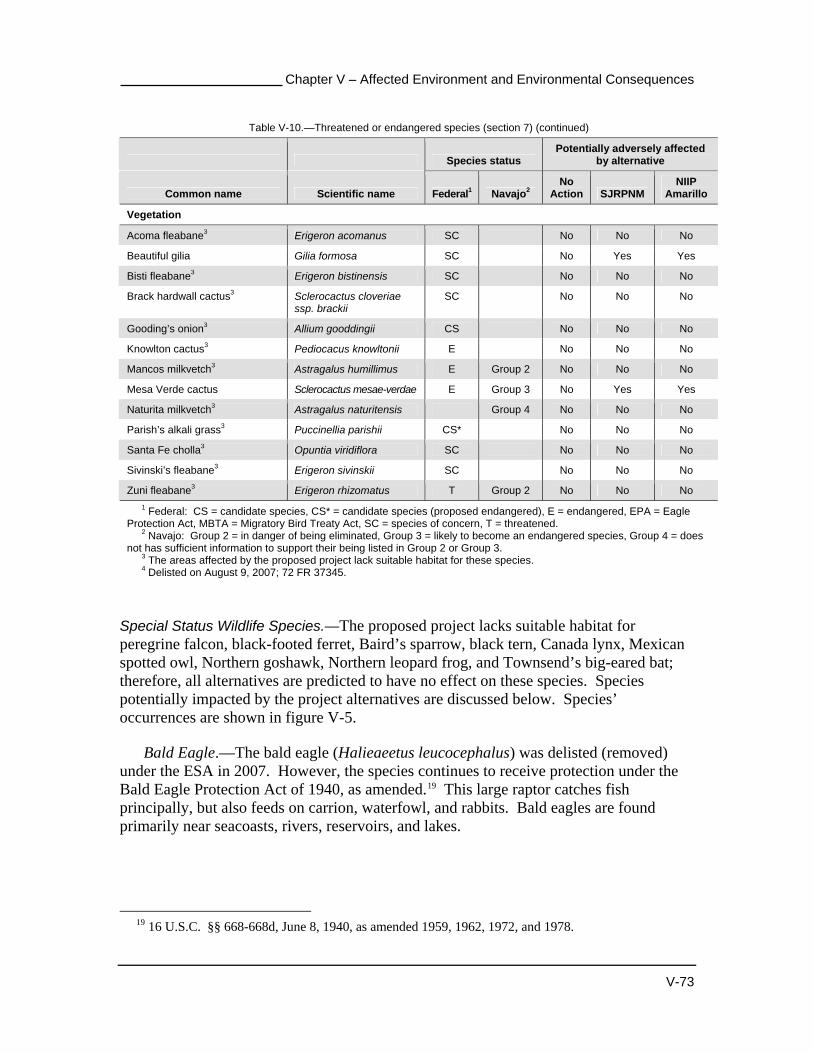
Chapter V – Affected Environment and Environmental Consequences
V-73
Table V-10.—Threatened or endangered species (section 7) (continued)
Species status Potentially adversely affected
by alternative
Common name Scientific name Federal1 Navajo2 No
Action SJRPNM NIIP
Amarillo
Vegetation
Acoma fleabane3 Erigeron acomanus SC No No No
Beautiful gilia Gilia formosa SC No Yes Yes
Bisti fleabane3 Erigeron bistinensis SC No No No
Brack hardwall cactus3 Sclerocactus cloveriae ssp. brackii
SC No No No
Gooding’s onion3 Allium gooddingii CS No No No
Knowlton cactus3 Pediocacus knowltonii E No No No
Mancos milkvetch3 Astragalus humillimus E Group 2 No No No
Mesa Verde cactus Sclerocactus mesae-verdae E Group 3 No Yes Yes
Naturita milkvetch3 Astragalus naturitensis Group 4 No No No
Parish’s alkali grass3 Puccinellia parishii CS* No No No
Santa Fe cholla3 Opuntia viridiflora SC No No No
Sivinski’s fleabane3 Erigeron sivinskii SC No No No
Zuni fleabane3 Erigeron rhizomatus T Group 2 No No No
1 Federal: CS = candidate species, CS* = candidate species (proposed endangered), E = endangered, EPA = Eagle Protection Act, MBTA = Migratory Bird Treaty Act, SC = species of concern, T = threatened. 2 Navajo: Group 2 = in danger of being eliminated, Group 3 = likely to become an endangered species, Group 4 = does not has sufficient information to support their being listed in Group 2 or Group 3. 3 The areas affected by the proposed project lack suitable habitat for these species. 4 Delisted on August 9, 2007; 72 FR 37345.
Special Status Wildlife Species.—The proposed project lacks suitable habitat for peregrine falcon, black-footed ferret, Baird’s sparrow, black tern, Canada lynx, Mexican spotted owl, Northern goshawk, Northern leopard frog, and Townsend’s big-eared bat; therefore, all alternatives are predicted to have no effect on these species. Species potentially impacted by the project alternatives are discussed below. Species’ occurrences are shown in figure V-5. Bald Eagle.—The bald eagle (Halieaeetus leucocephalus) was delisted (removed) under the ESA in 2007. However, the species continues to receive protection under the Bald Eagle Protection Act of 1940, as amended.19 This large raptor catches fish principally, but also feeds on carrion, waterfowl, and rabbits. Bald eagles are found primarily near seacoasts, rivers, reservoirs, and lakes.
19 16 U.S.C. §§ 668-668d, June 8, 1940, as amended 1959, 1962, 1972, and 1978.

Navajo-Gallup Water Supply Project
V-74
Figure V-5.—Special status wildlife within the proposed project area.

Chapter V – Affected Environment and Environmental Consequences
V-75
Ferruginous Hawk.—The ferruginous hawk (Buteo regalis) is a Navajo Nation endangered species (Group 3). Ferruginous hawks are found on semiarid plains and in arid steep habitats and favor relatively unbroken terrain. They prefer tall trees for nesting, but will use a variety of structures including mounds, short cliffs, cutbanks, low hills, haystacks, and human structures. Ferruginous hawks feed on ground squirrels, rabbits, pocket gophers, kangaroo rats, mice, voles, lizards, and snakes. Populations are adversely influenced by agricultural activities (DeGraaf et al., 1991). The ferruginous hawk occurs in low numbers in the northwest corner of New Mexico. Two ferruginous hawks were observed during field surveys for the proposed project (ESRI, 2002). One was seen hovering over the sagebrush flats southwest of Nageezi, New Mexico, and another was observed over the plains east of Sheep Springs, New Mexico. No nests were observed, although suitable areas may occur several miles east-southeast of Sheep Springs and along cliffs in Blanco and Cutter Canyons. NNHP records ferruginous hawks within 3 miles of the proposed project pumping and water treatment facilities and within 1 mile of the Cutter Lateral pipeline route (NNHP, 2003). Golden Eagle.—The golden eagle (Aquila chrysaetos) is a Navajo Nation endangered species (Group 3) and is also protected under the Bald Eagle Protection Act. Golden eagles are found in mountainous areas, canyons, grasslands, and shrublands and reside primarily in shrub-steepe habitats during the winter. They nest in large trees and on cliffs. Breeding success is often highly dependent on prey densities. Primary prey includes jackrabbits, larger rodents, birds, and reptiles (DeGraaf et al., 1991). One golden eagle nest is known historically from the ridge of the Nutria Monocline about 0.3 mile north of the proposed project pipeline. During recent surveys, a golden eagle was observed in flight along the San Juan River north of the San Juan Chapter and several were spotted along the SJRPNM pipeline route (ESRI, 2002). Although no active nests were detected during recent surveys, several areas of suitable nesting habitat are found in the proposed project vicinity. Large cottonwood trees near the SJRPNM’s Hogback-San Juan River pipeline crossing may provide nesting habitat. The Defiance Monocline near Window Rock, Arizona, and the Nutria Monocline east of Gallup, New Mexico, may provide cliff-nesting habitat. NNHP records show golden eagles within 1 mile of the proposed pipeline along the western lateral near Little Water, New Mexico, the eastern Cutter Lateral near Huerfano, New Mexico, and the distribution lateral to Window Rock (NNHP, 2003). Kit Fox.—The kit fox (Vulpes macrotis) is a Navajo Nation Group 4 species. Recent taxonomic studies include the kit fox as a subspecies of the swift fox (Vulpes velox macrotis). This subspecies inhabits arid grass and scrubland primarily, but may use woodland habitats. NNHP records show kit fox within 1 mile of the distribution lateral to Crownpoint, New Mexico. No signs of kit fox or fox were observed during surveys of

Navajo-Gallup Water Supply Project
V-76
the proposed project area (ESRI, 2002). Potential habitat occurs throughout much of the proposed project area wherever soils are adequate for denning and small mammals are abundant (NNHP, 2003). Mountain Plover.—The mountain plover (Charadrius montanus) is a Federal species of concern and a Navajo Nation Group 4 species. The mountain plover breeds in northeastern New Mexico and is only an incidental visitor in western New Mexico (BISON-M, 2002), although sightings have been documented within 1 mile of the proposed pipeline in the Star Lake, New Mexico, area (NNHP, 2003). Mule Deer.—The mule deer (Odocoileus hemionus) is listed by the Navajo Nation as an economically and culturally significant species and is found within the proposed project area. Pronghorn.—Pronghorn (Antilocapra Americana) are listed by the Navajo Nation as a Group 3 species. They are known from within 3 miles of the southern tip of the Cutter Lateral, and suitable habitat is found along the southern portions of the Cutter and Main Laterals (NNHP, 2003). Rocky Mountain Elk.—The Rocky Mountain elk (Cervus elaphus nelsoni) is economically significant to the Navajo Nation. Although once found over much of North America, elk now range primarily through the Rocky Mountains from northern Alberta to New Mexico and Arizona (Whitaker, 1980). Southwestern Willow Flycatcher.—The Southwestern willow flycatcher (Empidonax traillii extimus) is listed as federally endangered and listed by the Navajo Nation as a Group 2 species. The flycatcher’s range includes the Basin, but designated critical habitat does not include this drainage, nor was critical habitat proposed for the drainage (Service, 1993). Within the San Juan River drainage, populations of breeding flycatcher appear to have been quite small for many years. Woodsbury (1961) lists the flycatcher as a summer resident based on a single observation of a singing and feeding individual along the Piedra River in early July 1960. Schmitt (1976) lists the species as “occasional” at Kirtland, but overlooked and/or misidentified and thought to breed. Ecosphere, Inc. (2001) conducted presence-absence surveys along the San Juan River from Navajo Dam downstream to the confluence with Red Wash at about RM 132 in 1997, 1998, and 1999. One nesting pair producing one fledgling was identified in the flood plain along the San Juan River near the mouth of Malpais Arroyo (RM 142) in 1997. In addition, 14 undifferentiated flycatchers were identified on 12 of 24 sites surveyed. In 1998, four nests were found in the same location, with four flycatchers fledged from three of the nests. An additional 18 undifferentiated flycatchers were identified in 10 of

Chapter V – Affected Environment and Environmental Consequences
V-77
27 sites. In 1999, no nesting pairs and no fledglings were found, although 31 flycatchers were found in 10 of 21 sites surveyed. In 3 years of surveying, 57 percent of the sites detected flycatcher at some time during the year, although only one site demonstrated nesting. Further, flycatchers were detected in exotic as well as native riparian habitat, although nesting was only detected in high quality, native willow habitat (Ecosphere, 2001). The bulk of these birds may be using the riparian corridor as a temporary stopover to replace resources spent during migration. Similar use of larger rivers as important refueling sites for flycatcher as they migrate between breeding grounds and wintering grounds has been described along the middle Rio Grande River (Yong and Finch, 1997). Southwestern willow flycatchers are not necessarily restricted to willow/cottonwood complexes along larger rivers. They may also utilize suitable willow habitat away from these large rivers. Within the proposed project area, however, there is no suitable willow flycatcher habitat, nor has there historically been such habitat. This subspecies is not expected to use the proposed project service area. Western Burrowing Owl.—The Western burrowing owl is listed as a Federal species of concern. No records of Western burrowing owl are known from the proposed project area. Crop production limits the suitability of some project habitats for Western burrowing owl; other open habitats may be used, depending on the availability of burrows. Special Status Fish.— Species potentially impacted by the proposed project alternatives are discussed below. Species’ occurrences were shown in figure V-5. Zuni Bluehead Sucker – The Zuni bluehead sucker (Catostomas discobolus yarrowi) is a Federal candidate species and listed as a Navajo Nation Group 4 species. The historical range of the Zuni bluehead sucker, a subspecies of the bluehead sucker, is limited to the headwaters of the Little Colorado River and does not occur within the proposed project area. Colorado Pikeminnow – The Colorado pikeminnow (Ptychocheilus lucius) is protected as both federally endangered and a Navajo Nation Group 2 species. Colorado pikeminnow spawn from early July through mid-August. Preferred spawning sites are riffles with gravel to cobble substrates (Lamarra et al., 1985). The Colorado pikeminnow is endemic to the Colorado River Basin and historically inhabited the main river channels. It is now found in small numbers only in limited portions of the upper Colorado River Basin in Colorado, Utah, and New Mexico, occupying about 25 percent of its former range. Within the San Juan River, the Colorado pikeminnow has been collected from RM 0 to RM 177.1 (see figure V-5) (Ryden, 2000a and 2000b).
Navajo-Gallup Water Supply Project
V-78
Critical habitat for the Colorado pikeminnow is designated as the 100-year flood plain of the San Juan River from Neskahai Canyon in Lake Powell to the confluence of the San Juan and Animas Rivers (see figure V-4). Several factors have contributed to the decline of Colorado pikeminnow in the San Juan River. Water development, in particular the construction of Navajo and Glen Canyon Dams, has limited access to important habitats and altered the hydrology to which the Colorado pikeminnow is adapted. Competition with and predation by non-native species may also play a role. Historical chemical eradication of native species in favor of non-native game fish may have affected the population locally. Mark recapture20 estimates place 19 wild adult Colorado pikeminnow in the San Juan River from RM 136.6 to RM 119.2 (Ryden, 2000a). Radio-tagged adults appear to have relatively small home ranges and primarily use habitats from RM 109 to RM 142. The exception to this trend was one fish that consistently used habitats immediately downstream of Bluff, Utah, at RM 80 (Ryden, 2000a). Spawning has been documented in a region of high channel complexity characterized by shifting gravel bars from RM 133.4 to RM 129.8 (Ryden, 2000a). Additional suitable spawning habitat has been identified at RM 178.7 and RM 168.4 (Bliesner, 2003). Prior to spawning, some adults have staged at the mouth of the Mancos River. Spawning dates range from July 8 to August 12 (Platania et al., 2000). Larval and juvenile Colorado pikeminnow have been collected from low-velocity shoreline and pocketwater habitats downstream of RM 130 (Ryden, 2000a). Stocking of Colorado pikeminnow in the San Juan River began in 1996. In the San Juan River at RM 147.9 and RM 53, 827,000 larval Colorado pikeminnow were stocked. Overwinter survival was high (62.5–6.27 percent), and survival between Age-1 and Age-2 based on recapture rates neared 100 percent (Kimball et al., 2000). As a result of this initial success, an augmentation plan began in 2002 and called for stocking and monitoring 300,000 Age-0 Colorado pikeminnow at RM 180.2 and RM 158.6 for 7 years (Ryden and McAda, 2003). In addition to augmentation, ongoing recovery efforts include adult and larval fish monitoring, habitat and water quality monitoring, and control of non-native species. In 2003, the fish passage at the PNM weir was finished and put into operation. During the summer of 2003, nine Colorado pikeminnow used the fish passage (Lapahie, 2004). In 2004 and 2005, four and nine Colorado pikeminnow, respectively, used the PNM fish passage (Lapahie, unpublished data). One of the goals of the SJRBRIP is the expansion of the range of Colorado pikeminnow and removal of barriers to migration (SJRBRIP, 1995). The removal of the Cudei diversion dam and construction of a fish passage at the Hogback diversion dam in 2001 and the documented use of the fish passage at the PNM weir has provided opportunity for and documented use of this upper portion of the San Juan River by Colorado pikeminnow, an important step toward recovery.
20 Mark recapture estimates are population estimates based on the number of fish that are marked or tagged and recaptured over a series of samplings.
Chapter V – Affected Environment and Environmental Consequences
V-79
In 2005, 287 Colorado pikeminnow were collected during nonnative fish control activities in the lower San Juan River (Jackson, 2006). Population estimates ranged from 536–696 individuals. Captures of adult Colorado pikeminnow have diminished since the non-native fish control project began in 2002, and no adult Colorado pikeminnow were collected in 2005. Based on spawning dates in the San Juan River, larvae typically enter the drift from mid-July to mid-August (Platania et al., 2000) and are passive in the drift for 3 to 6 days after emergence (Dudley and Platania, 2000). Therefore, larval Colorado pikeminnow spawned above the diversion would be subject to entrainment for about 35 to 40 days. Flows during this period average about 1,500 cfs at the Farmington gauge (1993–2003; USGS, 2003). The proposed San Juan River intake would divert about 4 percent (59 cfs) of the total river during peak Colorado pikeminnow drift. Colorado pikeminnow exit the drift at 0.55 inch and would not be excluded by a 3/32 inch screen (Platania et al., 2000). Thus, it is estimated that about 4 percent of the larvae spawned above the intake would be subject to entrainment. Since only 25 percent or less of the spawn is expected above the proposed diversion, the net loss is expected to be less than 1 percent of all Colorado pikeminnow larvae produced in the San Juan River. Razorback Sucker – The razorback sucker (Xyrauchen texanus) is listed as federally endangered and as a Navajo Nation Group 2 species. Critical habitat for this species is designated as the San Juan River and its 100-year flood plain from Neskahai Canyon in Lake Powell to the Hogback diversion dam. The razorback sucker’s range is limited to the Colorado River drainage. Currently, it occurs in portions of the Green River in Utah and the upper Colorado River in Colorado. The largest remaining wild population is in Lake Mohave, Arizona-Nevada. Beginning in 1994, razorback sucker were reintroduced in the San Juan River. This population is reproducing and larval/juvenile razorback sucker have been recaptured from RM 0 to RM 135 (Brandenburg et al., 2002). Stocked razorback sucker use a variety of habitats seasonally. During the cold, winter months they select areas of high habitat diversity. During June, when inundated vegetation is available, razorback sucker use these areas. From August through October, razorback sucker inhabit fast run habitats. Razorback sucker have been documented spawning near Aneth, Utah, at RM 152.2. Reproduction has been documented by the capture of larval razorback sucker since 1999, with substantial increases in capture rates since 1994 (Brandenburg et al., 2002). Augmentation through stocking is the current focus of razorback sucker recovery efforts on the San Juan River. During the aforementioned 5-year stocking period, fewer fish were available than were called for in the augmentation plan (Ryden and McAda, 2003). Thus, the augmentation plan has been extended to include 11,400 Age-2 razorback suckers per year through 2011. The goal of this augmentation is to establish an adult population of 5,800 razorback suckers. Several grow-out ponds have been established, and more are being developed, to meet the demand of this stocking effort. Additional

Navajo-Gallup Water Supply Project
V-80
recovery efforts include mimicry of a natural hydrograph, larval razorback sucker monitoring, control of non-native fish, habitat monitoring, and removal of barriers to fish passage. Removal of the Cudei diversion and construction of fish passage structures at the Hogback and PNM diversion provide access above the upper end of the razorback sucker’s designated critical habitat. Razorback sucker have been documented at the PNM fish passage in 2003 (Lapahie, 2004), indicating the use of the river above designated critical habitat and above the PNM diversion. Roundtail Chub – The roundtail chub (Gila robusta) is listed as a Federal species of concern and by the Navajo Nation as a Group 2 species. It is found in the larger streams of the Colorado Basin from California and Wyoming south to Arizona, New Mexico, and Mexico. Bluehead Sucker – The bluehead sucker (Catostomus discobolus) is listed as a Navajo Nation Group 4 species. It is widespread throughout the Colorado River Basin and is also found in Idaho, Wyoming, Nevada, and Utah in the upper Snake, Bear, Walker, and Weber River drainages (BISON-M 2002; Valdez, 1990). This sucker inhabits small streams to large rivers and prefers fast-moving water over rocky substrates and relatively cool, clear conditions (Woodling, 1985; McAda, 1977; Holden and Stalnaker, 1975). Bluehead sucker are the second most abundant native species and the third most abundant fish overall in the San Juan River from RM 53 to RM 180 (Ryden, 2000a). The bluehead sucker is found in very limited numbers upstream of RM 205, where introduced trout are the dominant species (Wethington, 2002). The highest catch rates for bluehead sucker occur within Reaches 5 and 6; downstream of this area the catch-per-unit effort (CPUE) declines dramatically with each consecutive reach, and no bluehead sucker have been caught below RM 17 (Ryden, 2000a). Large juvenile and adult fish are most common within Reach 6. Downstream of Reach 6, juveniles make up more of the CPUE, although there is no longitudinal trend in size class (K. Lawrence, personal communication, 2003). During the period of test flows from 1991–97 from Navajo Dam to more closely mimic a natural hydrograph, bluehead sucker CPUE decreased throughout most of the San Juan River. This trend was reversed in 1998 and 1999; the catch of bluehead sucker increased (Ryden, 2000b). Decreasing trends did not occur within Reach 6. CPUE of bluehead sucker increased from 1991 through 1999. At times, over one-half the total catch of bluehead sucker occurred within Reach 6 (Ryden, 2000a). Reach 6 appears to be an important spawning area, and the number of large bluehead sucker present here may provide an important prey base for Colorado pikeminnow (Holden, 1999). Mottled Sculpin – The mottled sculpin (Cottus bairdi) is listed as a Navajo Nation Group 4 species. Mottled sculpin within the Colorado River drainage are considered a unique subspecies.

Chapter V – Affected Environment and Environmental Consequences
V-81
This species is infrequently collected in the San Juan River in part because most surveys have focused on the middle and lower portions of the river and boat electrofishing does not effectively sample this small, benthic species (K. Lawrence, personal observation). Even so, the mottled sculpin is probably not abundant in the San Juan River, and most specimens have been collected upstream of Hogback diversion (Ryden, unpublished data). Special Status Plants.—The proposed project area lacks suitable habitat for the Federal and Navajo Nation sensitive species including the Acoma fleabane, bisti fleabane, Brack hardwall cactus, Gooding’s onion, Knowlton’s cactus, Mancos milkvetch, Naturita milkvetch, Parish’s alkali grass, Santa Fe cholla, Sivinski’s fleabane, and Zuni fleabane. Therefore, these species are not discussed in any detail in this section. This section focuses on Federal and Navajo Nation sensitive plant species that may be adversely affected by the proposed project (figure V-6). Beautiful Gilia – Beautiful gilia (Gilia formosa) is a Federal species of concern and is found only in San Juan County on soils derived from the Nacimiento Formation. Beautiful gilia is also known as Aztec gilia. It grows in association with desert salt scrub communities at elevations from 5000 to 6000 feet (New Mexico Rare Plant Technical Council [NMRPTC], 1999). Mesa Verde Cactus – The Mesa Verde cactus (Sclerocactus mesa-verdae) is listed as a federally threatened species and as a Navajo Nation Group 3 species. It is found in San Juan County, New Mexico, and Montezuma County, Colorado (NMRPTC, 1999). Mesa Verde cacti grow in highly alkaline, gypsiferous soils on low, rolling hills formed by the Mancos and Fruitland shale formations at 4900 to 5500 feet. The growth of Shiprock, New Mexico, oil and gas development, and off-road vehicle use threaten populations of the Mesa Verde cactus (NMRPTC, 1999). NNHP records indicate populations of Mesa Verde cactus within 1 mile of the proposed project main lateral (NNHP, 2003). During field surveys along the main pipeline lateral route adjacent to Route 491, fewer than 100 individual Mesa Verde cactus were documented in one population. The population is located south-southeast of the junction of Route 491 and Navajo Route N36 and is within the boundary of the proposed pipeline alignment. Three additional areas of potential habitat were documented: (1) south of the junction of Route 491 and Navajo Route N36 for approximately 15 miles to the vicinity of Little Water, New Mexico; (2) north of Route 491 and west of the Hogback; and (3) immediately east of the Hogback from the Amarillo Canal to Route 491. During the spring and early summer of 2002, additional surveys were conducted in these areas (ESRI, 2002). Approximately 150 acres were surveyed. No Mesa Verde cacti were
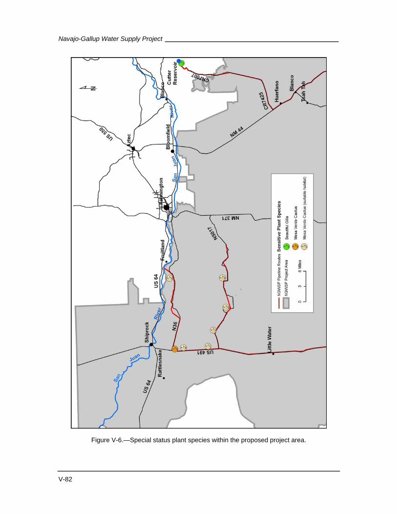
Navajo-Gallup Water Supply Project
V-82
Figure V-6.—Special status plant species within the proposed project area.
Chapter V – Affected Environment and Environmental Consequences
V-83
observed; however, the area experienced a prolonged drought. During drought conditions, cacti recede into the ground and become very difficult to distinguish. Special Status Species – Methodology Special Status Wildlife.—Reports from the NMDGF, NNHP, and BISON-M were reviewed to compile descriptions of sensitive wildlife in the proposed project area. In addition, field surveys were conducted on approximately 290 miles of the proposed pipeline alignments. Each alignment was walked in increments along the centerline and wildlife observations were made on both sides. Binoculars and close visual inspections were used throughout the survey. All potential habitats for threatened and endangered wildlife were examined. Furthermore, sandstone cliffs, large trees, and utility structures within one-quarter mile of the proposed pipeline alignments were visually checked for raptor nests, perching, and roosting sites. Both direct sightings and indirect evidence (tracks, dropping, burrows, and others) were used to document wildlife presence in the proposed project area (ESRI, 2002). Special Status Fish.—Data previously collected by the SJRBRIP were used to evaluate impacts to special status fish. No field surveys were conducted. Special Status Plants.—Reports from the NMGFD, NNHP, and BISON-M were reviewed to compile descriptions of sensitive plants in the proposed project area. In addition, field surveys were conducted on approximately 290 miles of the proposed pipeline alignment (for more information, see the description for “Special Status Wildlife” under “Special Status Species Methodology,” above). Special Status Species – Impacts Analysis The alternatives would have no potential impacts to the following special status species: mule deer, pronghorn, Rocky Mountain elk, mountain plover, and roundtail chub.21 There are potential impacts to the following special status species for both action alternatives:
21 Habitats are generally poor in the project area for Rocky Mountain elk, so they are expected to avoid these areas and any adverse impacts during construction activity. Although a limited number of roundtail chub have been documented above the proposed PNM intake, the roundtail chub is not expected to be impacted.
Navajo-Gallup Water Supply Project
V-84
• Ferruginous hawk • Golden eagle • Kit fox • Western burrowing owl • Colorado pikeminnow • Razorback sucker • Beautiful gilia • Mesa Verde cactus
No Action Alternative.—The No Action Alternative would have no impact on special status species in the proposed project area. SJRPNM Alternative.— The SJRPNM Alternative would potentially impact three additional special status species—bald eagle, Southwestern willow flycatcher, and bluehead sucker. These species are briefly discussed below. Bald Eagle – Under the SJRPNM Alternative, wintering eagles that feed in the San Juan River may be temporarily displaced by construction activity near the PNM diversion. These eagles would likely use other areas of the river and the proposed project area when equipment is idle. Ferruginous Hawk – The SJRPNM and NIIP Amarillo Alternatives have the potential to affect ferruginous hawks. This species is known to nest within 1 mile of the proposed Cutter Lateral pipeline route, which is a common feature to both alternatives (NNHP, 2003). Construction activities in these areas may disrupt nesting and could lead to nest failures. Project operation is not expected to adversely affect the ferruginous hawk, and no nesting habitats will be damaged by the proposed project; thus, long-term effects are not anticipated. Golden Eagle – The SJRPNM and NIIP Amarillo Alternatives have the potential to adversely affect the golden eagle. Golden eagles are known to nest within 1 mile of the proposed pipeline route (NNHP, 2003). Kit Fox – The SJRPNM and NIIP Amarillo Alternatives have the potential to cause local effects on the kit fox. This species has been documented within 1 mile of the proposed pipeline alignment for the SJRPNM and NIIP Amarillo Alternatives. Southwestern Willow Flycatcher.—Under the SJRPNM Alternative, construction activities at the PNM diversion may affect the Southwestern willow flycatcher. The impact area was surveyed in 1999 with no flycatchers found, although the habitat
Chapter V – Affected Environment and Environmental Consequences
V-85
determination was “good” (Ecosphere, 2001). However, much of the vegetation in the area rated as “good” was removed during the construction of the PNM fish ladder. Most of the remaining habitat is “marginal.” The SJRPNM Alternative may affect, but is not likely to adversely affect, the Southwestern willow flycatcher. This species is rare along the San Juan River. Less than an acre of exotic riparian shrub habitat would be removed for project structures, and approximately 17 acres of the same tamarisk habitat may be disturbed during construction. Monotypic tamarisk stands typically provide marginal habitat for the flycatcher, and it is unlikely that this species would be affected by project activities. During higher flow periods when the Navajo Dam release is at its minimum, the flow below the PNM diversion would be slightly reduced (less than 0.5 percent on average) with negligible effect on potential habitat. Upstream of Navajo Dam, the average reservoir level would be slightly higher (about 2 feet) under project operation compared to baseline, with no difference in change between high and low flow levels each year. Further, inflow would be slightly higher as a result of the transfer of water from the JANNRWSP to the proposed project, so no impacts to Southwestern willow flycatchers above the reservoir are expected. Western Burrowing Owl – The SJRPNM and NIIP Amarillo Alternatives have the potential to affect Western burrowing owl by project-related ground disturbance. This species was not observed during general wildlife surveys in the proposed project area; however, suitable habitat may be found along the proposed pipeline routes. Any Western burrowing owl nesting along the proposed alignments would be displaced by construction activity. Protective measures include conducting burrowing owl surveys within potential habitat prior to ground-disturbance activities. If active nests were found in the construction area, an appropriate mitigation plan would be developed. Colorado Pikeminnow – Under the SJRPNM and NIIPAmarillo Alternatives, the critical elements of the Flow Recommendations would be met, as shown in table V-9 and as previously discussed in the “Aquatic Resources” Section. All but two of the flow criteria are met for the worst-case scenario, and these criteria have been determined by the SJRBRIP to be ineffective in accomplishing the anticipated results (Miller, 2005). Under the SJRPNM Alternative, the Flow Recommendations are met 99.99 percent of the time. Although the SJRPNM Alternative meets the critical elements of the Flow Recommendations, it has the potential to adversely affect Colorado pikeminnow because entrainment of Colorado pikeminnow at the PNM intake might occur. Entrainment of adult and subadult Colorado pikeminnow is limited because of the incorporation of a 3/32-inch fish screen in the proposed project designs, but larval Colorado pikeminnow may still become entrained. While no spawning sites have been documented above this

Navajo-Gallup Water Supply Project
V-86
diversion, the quality of gravel bars suggests spawning potential between the PNM diversion and Farmington, New Mexico (Bliesner, 2003). Given the known range of spawning and the availability of spawning habitat above the diversion, up to 1 percent of Colorado pikeminnow larvae may become entrained at the proposed San Juan River intake under the SJRPNM Alternative. While this impact would be adverse, it would be negligible. The SJRBRIP would continue to be implemented. The San Juan River intake structure, pump, and pipeline would be constructed within designated critical habitat for Colorado pikeminnow, but no adverse modification of critical habitat is predicted. Flows upstream of the PNM weir would actually be greater with the proposed project than current baseline conditions, and water quality risks would remain low. Razorback Sucker – Under the SJRPNM Alternative, the razorback sucker may also be adversely affected by the possible entrainment of larval fish during spawning. Spawning typically occurs on the ascending limb of the hydrograph during May (Brandenburg et al., 2002). With an assumed potential spawning range from Aneth, Utah, to Farmington, New Mexico (RM 100 to 180), and a uniform distribution of spawning adults in the future, about 16 percent of the larval drift may occur above the proposed PNM diversion. During May, the flow averages about 4,300 cfs, of which 59 cfs (1.4 percent) would enter the proposed project’s PNM diversion under the SJRPNM Alternative. Not more than 0.2 percent of the nonretained drifting larvae are predicted to become entrained in the diversion. While this impact is adverse, it is also negligible. Bluehead Sucker.—Under the SJRPNM Alternative, a portion of the bluehead sucker population would also be vulnerable to entrainment and impingement with intake facilities. Forty percent of Age-1+ bluehead sucker in the San Juan River are found upstream of the proposed intake structure (ESRI, 2003b). Up to 0.4 percent of drifting larval bluehead sucker in the San Juan River may be subject to entrainment. The predicted loss is also negligible. The SJRBRIP would continue to be implemented. Beautiful Gilia.—The SJRPNM Alternative has the potential to adversely affect beautiful gilia. Approximately 100 plants are documented east of the proposed pipeline route centerline about 1,000 feet south of Cutter Dam (ESRI, 2002). These plants may be disturbed or displaced by the water treatment facility planned for the base of Cutter Dam. The pipeline exiting Cutter Dam may also disturb this population. Beautiful gilia populations on disturbed sites appear to recover over time (NMRPTC, 1999). Mesa Verde Cactus.— The SJRPNM and NIIP Amarillo Alternatives have the potential to adversely affect the Mesa Verde cactus. The single population documented within the boundary of the main lateral and an associated pumping plant would be impacted (ESRI, 2002 and 2003c). Additional habitat is found along the main lateral, and several populations are found within a mile of the main lateral alignment (NNHP, 2003).

Chapter V – Affected Environment and Environmental Consequences
V-87
Section 7 Consultation.—Reclamation formally consulted with the Service on the SJRPNM Alternative, and a final biological opinion dated February 26, 2009, was issued for the proposed project (volume II, appendix C, part III). The opinion concludes that the 5,721 acre-feet of new depletions associated with the proposed project will not jeopardize the continued existence of the Colorado pikeminnow, razorback sucker, or Mesa Verde cactus, or adversely modify their designated critical habitat. The opinion includes an incidental take statement. Conservation and RPMs are discussed below. NIIP Amarillo Alternative.—With the exception of sensitive fish and riparian-dependent species previously discussed, all other sensitive species effects would be similar to those described under the SJRPNM Alternative. Because all project water would be delivered via the NIIP intake in Navajo Reservoir, there is no potential for entrainment of Colorado pikeminnow, razorback sucker, or bluehead sucker. No Southwestern willow flycatcher or bald eagle habitat would be affected under the NIIP Amarillo Alternative. Critical elements of the Flow Recommendations would be met, as previously discussed in the SJRPNM Alternative. Special Status Species – Mitigation Measures Potential mitigation measures to avoid or minimize impacts to affected sensitive species are discussed below. Conservative measures and RPMs included in the biological opinion (volume II, appendix C, part III) are also discussed.22
• Proposed measures for ferruginous hawk and bald eagle include conducting surveys of the proposed construction areas 1 year in advance of construction for pipeline routes and construction sites that are not adjacent to highways, well-traveled roads, or areas of regular human activities. If active nests are found as a result of the surveys, appropriate protective measures could be developed to avoid or minimize nest disturbance.
• Construction could be managed to avoid intentional disturbance of dens for
kit fox, as construction activities may discourage or disrupt denning activities.
22 RPMs are measures to reduce incidental take of threatened or endangered species defined in the biological opinion as terms and conditions. The terms and conditions are nondiscretionary actions required by the action agency and are not included as mitigation measures.
Navajo-Gallup Water Supply Project
V-88
• Conservation measures for Southwestern willow flycatcher include surveying prior to construction suitable habitat within ¼ mile of the disturbed area and avoiding activity during the nesting period (March 15 to August 15) if the species is found. Any riparian vegetation removed may be replaced with appropriate native species, either onsite if the disturbance is temporary, or at an alternative location if the disturbance is permanent, as described in the “Vegetation Resources” section.
• Mitigation measures for beautiful gilia should include delineating and avoiding
plants where possible.
• Conservation mitigation measures to protect existing populations of Mesa Verde cactus include:
1. Prior to the completion of final design, Reclamation will inventory known
populations and suitable Mesa Verde cacti habitat within 500 feet of the proposed pipeline alignment, pumping plant, and construction footprint. Because initial pre-engineering surveys were conducted in 2001 and 2002 during the drought, and because it will be many years between when the initial surveys were conducted and the project will be constructed, it is important that these areas be surveyed again.
2. Based on the results of these inventories, Reclamation will develop a
detailed Mesa Verde Cactus Construction Plan (Construction Plan) for the purposes of avoiding and minimizing disturbance to Mesa Verde cacti and suitable habitat to the greatest extent possible. The Construction Plan will be submitted to the Service and Navajo Nation for review. Specific locations of cacti will be kept confidential, and no Universal Transverse Mercator coordinates or similar location data will be included in the final report available to the general public.
3. Construction areas, including pipeline alignments, pumping plants,
temporary and permanent access roads, staging areas, etc., will be located in coordination with project engineers and Reclamation resource specialists to avoid individual cactus and habitat identified during the inventories. To the extent practicable, impacts to Mesa Verde cacti and/or suitable Mesa Verde cacti habitat will be minimized. Existing roads and previously disturbed areas (i.e., power lines, fence lines, prior construction staging areas) will be utilized, where possible, to minimize impacts. If temporary construction access roads are needed that will be situated closer than 50 feet from known individual cactus locations, these plants will be monitored during road use. The edges of these access roads will be flagged in the field.

Chapter V – Affected Environment and Environmental Consequences
V-89
4. When construction is complete, temporary access roads and staging areas within suitable Mesa Verde habitat will be closed and hand-raked to remove tire tracks. Because of the delicate nature of the soil structure in areas that support Mesa Verde cacti, no post-construction reseeding will be implemented in these areas.
5. Pre-construction surveys for Mesa Verde cacti will be conducted in the
spring of the year preceding the initiation of construction activities to identify any new cacti. All areas that may be affected (directly or indirectly) by construction, operation, or maintenance of the pipeline and pumping plant will be surveyed. The locations of any additional cacti identified during the pre-construction surveys will be incorporated into the Construction Plan. Appropriate mitigation measures will be developed in consultation with the Service and the Navajo Nation if impacts to these new plants cannot be avoided.
6. Reclamation will develop an education program for all Reclamation field
staff and all contractor employees regarding identification and conservation of the Mesa Verde cactus. The program will include information about the legal and biological status of the Mesa Verde cactus, the importance of habitat preservation, the occurrence of cactus and suitable habitat in the area, the Construction Plan, fines for damaging or removing cacti, and procedures for reporting cacti not previously indentified.
7. All sites where Mesa Verde cacti are present will be fenced or flagged as
detailed in the Construction Plan and monitored daily by Reclamation personnel when construction activities are ongoing in the vicinity. Fencing will extend 200 feet in both directions along access roads beyond the limits of each site. Where possible, fencing will include a 50-foot buffer around any known cacti during construction activities. All fencing will be inspected daily and maintained as needed to ensure adequate protection. All construction contracts will have “stop work clauses” if new cacti are discovered. Any disturbance to cacti observed by construction personnel will be reported immediately to Reclamation. A written account, including a map, extent of the disturbance, the number of cacti, and the circumstances surrounding the disturbance, will be submitted to the Service and Navajo Nation within 48 hours.
8. All traffic will be limited to routes specified in the Construction Plan via
designated work area and access roads that were previously inventoried for Mesa Verde cacti. Cross-county travel within occupied and/or suitable Mesa Verde cactus habitat will be strictly prohibited.

Navajo-Gallup Water Supply Project
V-90
9. To reduce the likelihood of noxious plants, cleaning of construction equipment will be required before entry into occupied or suitable Mesa Verde cacti habitat.
10. Routine post-construction inspections of the pipeline in suitable Mesa Verde
cacti habitat will be performed using defined access roads. Additional surveys for Mesa Verde cacti in suitable habitat will be required prior to any ground- disturbing activity for maintenance. Survey results will be valid for 3 years.
11. Where features cannot be re-routed or moved to avoid impacts to an
individual Mesa Verde cactus, the cactus will be transplanted in suitable habitat in cooperation with the Service and the Navajo Nation as described in the Construction Plan. Transplanted cacti will monitored for a minimum of 5 years. Applicable permits from the Service and Navajo Nation will be obtained prior to transplanting Mesa Verde cactus.
12. Noxious weeds will be continually controlled within disturbed areas.
Conservation measures for the San Juan River and other water crossings to protect endangered fish and their designated critical habitat include:
1. Silt curtains, cofferdams, dikes, straw bales, or other suitable erosion control measures will be used to prevent erosion from entering water bodies during construction.
2. Water quality parameters will be monitored before, during, and after
construction to ensure compliance with State Water Quality Standards. In-water work will stop if State Water Quality Standards are exceeded at or below the worksite due to construction activities.
3. Construction of the cofferdam will be scheduled during minimal low flows to
avoid and minimize direct or indirect effects to fish species. Riverflows upstream and downstream of construction areas will be maintained. Fish passage around dewatered construction areas will be maintained at all times.
4. A fish net barrier will be installed upstream and downstream of the construction
site during construction to exclude fish from the work area during periods of in-water work.
5. Reclamation will coordinate with the Service to have a biologist(s) onsite to
rescue any fish species stranded as a result of construction activities.

Chapter V – Affected Environment and Environmental Consequences
V-91
6. Concrete pours will occur in forms and/or behind cofferdams to prevent discharge into the river. Any wastewater from concrete-batching, vehicle washdown, and aggregate processing will be contained and treated or removed for offsite disposal.
7. Fuels, lubricants, hydraulic fluids, and other petrochemicals will be stored and
dispensed outside the 100-year flood plain in an approved staging area. Equipment will be inspected daily for petrochemical leaks. Construction equipment will be parked, stored, and serviced only at an approved staging area outside of the 100-year flood plain.
8. An oil spill response plan will be prepared for areas of work where spilled
contaminants could flow into water bodies. All employees and workers, including those under separate contract, will be briefed and made familiar with this plan. The plan will be developed prior to initiation of construction. An oil spill response kit, which includes appropriate-sized spill blankets, shall be easily accessible and onsite at all times.
9. Onsite supervisors and equipment operators will be trained and knowledgeable
in the use of spill containment equipment. 10. Appropriate Federal and State authorities will be immediately notified in the
event of any contaminant spill. Disturbed areas within the wetted channel will be covered with clean cobble or quarry stone from an upland source. Disturbed areas adjacent to the wetted channel will be stabilized and planted with native riparian vegetation. The following RPMs were included in the incidental take statement of the biological opinion for the proposed project (volume II, appendix C, part III).
1. Reclamation will continue to support and participate in the implementation of the SJRBRIP.
2. Through the SJBRIP, Reclamation shall implement measures to create and
maintain habitat complexity and to minimize loss and long-term degradation of habitat for the endangered fishes within the San Juan River.
3. To project future flow regimes in the San Juan River through the SJRBRIP,
Reclamation will be responsible for the maintenance and application of the San Juan Hydrology Model to evaluate proposed projects on the San Juan River.
Navajo-Gallup Water Supply Project
V-92
Terms and conditions described in the biological opinion to implement the RPMs include:
1. Reclamation will continue to seek and provide funding, as authorized, for the implementation of the SJRBRIP.
2. To create and maintain complex habitat, Reclamation, through the SJRBRIP, will:
a. Investigate the use of habitat manipulation such as non-native vegetation
removal, mechanically opening the mouths of secondary channels, or reconnecting the river with the flood plain in appropriate sites to augment the function of high flows. Any resulting appropriate options should be implemented and funded through the SJRBRIP.
b. Continue to monitor habitat response to the Flow Recommendations. c. Monitor the response of actions taken to increase habitat complexity.
3. To track potential climate changes and how these changes may affect the
Colorado pikeminnow and razorback sucker and their designated critical habitats, Reclamation, in cooperation with the SJRBRIP, will begin monitoring to: a. Determine changes in the timing of runoff. b. Determine if average annual runoff is decreasing and a timeframe in which a
change may affect the ability of the Flow Recommendations to be met. c. If, from the monitoring activities listed above, it is determined that climate
change is affecting water availability in the San Juan River, this would be considered new information that may affect listed species or designated critical habitat. Reclamation would reinitiate consultation with the Service, consistent with Section 7.0 D (2) of the “Principles for Conducting Endangered Species Act Section 7 Consultations on Water Development and Water Management Activities Affecting Endangered Fish Species in the San Juan River Basin” adopted by the SJRBRIP on June 19, 2001. Reclamation, in consultation with the Service, would evaluate the changes in water availability and determine if the changes would have an adverse effect on listed species and if the SJRBRIP is sufficient to serve as the reasonable and prudent alternative or measure.
4. To ensure the integrity, consistency, and scientific rigor in regards to water
project depletions, Reclamation, working through the SJRBRIP, will:
Chapter V – Affected Environment and Environmental Consequences
V-93
a. Continue maintenance and upgrades of the San Juan Hydrology Model using the best available science
b. Conduct project analysis for water depletion projects on the San Juan River as
needed Special Status Species – Summary of Impacts Both action alternatives have the potential to affect Colorado pikeminnow, razorback sucker, ferruginous hawk, golden eagle, kit fox, Western burrowing owl, beautiful gilia, and Mesa Verde cactus. However, implementation of mitigation, conservation, and RPMs would avoid or reduce impacts for most sensitive species. The SJRBRIP would continue to be implemented to recover Colorado pikeminnow and razorback sucker in the San Juan River. The SJRPNM Alternative has the potential to affect three additional species: bald eagle, Southwestern willow flycatcher, and bluehead sucker. Formal consultation with the Service (volume II, appendix C, part III) determined that the SJRPNM Alternative will not jeopardize the continued existence of the Colorado pikeminnow, razorback sucker, or Mesa Verde cactus, or adversely modify their designated critical habitat. The Service concurred with Reclamation’s determination that the SJRPNM Alternative would not result in adverse modification of designated critical habitat for the Colorado pikeminnow or razorback sucker. The opinion also includes an incidental take statement. Conservation and RPMs were discussed previously.
Recreation This section addresses the potential impacts to recreation that could result from actions associated with the proposed project under the alternatives considered. Issue: How would the No Action, SJRPNM, and NIIP Amarillo Alternatives affect
recreation?
O v e r v i e w Scope
The recreation analysis includes Navajo Reservoir and the San Juan River corridor from Navajo Dam to the Clay Hills rafting take-out area near Lake Powell in the Glen Canyon National Recreation Area.

Navajo-Gallup Water Supply Project
V-94
Impact Indicators
Impacts were measured using various indicators, including changes in:
(1) Visitor recreation experience (2) Traditional uses (e.g., fishing, camping, hunting, and rafting) (3) Fishery habitat (4) Riverflow levels
Recreation – Affected Environment The study area is analyzed in four river segments and two general recreation areas (figure V-7): (1) Navajo Reservoir; (2) San Juan River corridor from Navajo Dam to Blanco, New Mexico; (3) San Juan River corridor from Blanco, New Mexico, to Montezuma Creek; (4) San Juan River corridor from Montezuma Creek to Clay Hills, Utah; (5) general recreation on the Navajo Nation lands within the proposed project area; and (6) general recreation on the Jicarilla Apache lands within the proposed project area. Navajo Reservoir.—About 80 percent of Navajo Reservoir and its associated lands are located in New Mexico and approximately 20 percent in Colorado. The reservoir and lands that immediately surround it offer a variety of water-based recreation opportunities, at least one-half of which center on abundant fishing opportunities for a variety of fish, including bass, trout, crappie, northern pike, and kokanee salmon. As the lake waters warm in the summer, usage shifts to water-based sports such as water skiing. In recent years, there has been a noticeable increase in the number of family groups on summer vacation from Colorado visiting the reservoir. Other popular activities are boating, vacation from Colorado visiting the reservoir. Other popular activities are boating, swimming, picnicking, camping, and, to a lesser degree, hiking, wildlife viewing, and hunting. While the United States owns the reservoir and lands within the reservoir boundary, recreational uses are administered primarily by the Colorado Division of Parks and Outdoor Recreation and the New Mexico Department of Parks and Recreation (NMDPR). The parks are open year round, with seasonal closures in some areas to conserve natural and park resources. Developed Recreation – Developed recreation facilities currently available for public use at Navajo Reservoir include swimming beaches, marinas, boat launch facilities, campgrounds, numerous picnic areas, and hiking trails. Extensive renovations of recreation facilities on the Colorado side were completed in 2002. Improvements

Chapter V – Affected Environment and Environmental Consequences
V-95
Figure V-7.—San Juan River segments and general recreation areas
potentially affected by the proposed project. included construction of a large parking lot, a new fishing access, 3 campgrounds totaling 110 sites, an enlarged amphitheater at the existing campground, additional picnic sites, rental cabins, a group-use area, and a new park headquarters. Undeveloped Recreation – Concentrated use in Colorado occur at Arboles Point and several locations along the San Juan and Piedra arms of Navajo Reservoir. The San Juan and Piedra Rivers are both popular trout fishing areas. Kokanee salmon snagging is seasonally allowed within the Navajo Recreation Area. Designated roads provide easy vehicular access to parking areas near the reservoir from both the east and west sides of the Piedra arm, where day use (picnicking, fishing, and hiking) and primitive camping in designated areas regularly occurs throughout the summer recreation season. In New Mexico, dispersed use occurs at many locations, with access provided by numerous roads developed for natural gas production. In addition, the many coves of the reservoir are attractive for camping and exploring by boat. Water skiing is allowed on most of the reservoir except in some of the canyons where the channel becomes too narrow or shallow to safely ski.

Navajo-Gallup Water Supply Project
V-96
Park Visitation Levels – Visitation to Navajo Reservoir has increased by 61 percent since 1990, an average rate of 8.6 percent per year. In 1999, total visitation equaled 534,099 in the New Mexico portion of Navajo Reservoir. Boating and camping uses on the reservoir are concentrated within a 4-month period, while the San Juan River attracts heavy use on a year-round basis. Additional information on visitation levels, visitor profiles, visitor activities, and satisfaction levels can be found in the Navajo Reservoir Operations FEIS (Reclamation, 2006). San Juan River.— Navajo Dam to Blanco, New Mexico (Tailwater Trout Fishery) – Navajo Dam tailwater is a unique environment characterized by cobble substrate and cool hypolimnetic releases. The NMDGF manages the tailwater as a trout fishery from the base of Navajo Dam 17 miles downstream to Blanco, New Mexico. The upper 4 miles are managed as special trout water. Regulations within the first one-quarter mile require catch-and-release using only barbless flies and lures. The remaining 3.75 miles carry the same tackle restrictions, but anglers are allowed to keep one fish over 20 inches per day. Immediately downstream of the special trout water for 3.3 miles (to the confluence of the San Juan River and Gobernador Arroyo) are regular regulation waters. NMDGF imposes no tackle restrictions in this reach and allows a daily bag limit of five fish. The remaining 10 miles of river to Blanco, New Mexico, are under the same regulations, but are bordered by private land and less accessible to anglers (Wethington, 2002). Hunting activities on the river are restricted to waterfowl and small game, while the surrounding areas offer opportunities such as camping, picnicking, hiking, wildlife viewing, and bird watching. Along this reach, day-use areas provide fishing access to the San Juan River and, in some cases, boating access. No recreational boats are allowed for the first 1.5 miles below the dam; beyond that, float fishing is popular. In 2002, 43 outfitters and 89 guides were licensed to operate on this reach of the San Juan River (Reclamation, 2006). Outfitters are not limited on the number of days they can operate. Most outfitters (93 percent) that use dory boats put in at the Texas Hole Day-Use Area below Navajo Dam and take out at the Gravel Pit Day-Use Area at the end of the quality waters. Annual NMDGF electrofishing surveys from 1997–2001 found an increasing percentage of brown trout in the special trout water and regular regulation reaches. Increases in brown trout numbers may be due to improved spawning success associated with high spring releases from Navajo Dam. The average length of rainbow trout from the special regulation waters was 15 inches, and on average, 18 percent of the rainbow trout were over 18 inches. In contrast, less than 2 percent of trout in the regular regulation waters

Chapter V – Affected Environment and Environmental Consequences
V-97
were over 18 inches; trout in regular regulation waters averaged 9 inches. Since then, NMDGF has managed the effects of whirling disease by stocking only fish 4 inches or larger (Wethington, 2002). Further downstream, very good brown and rainbow trout fishing from Citizens Ditch to Hammond diversion (within Navajo Dam to the Blanco stretch of the San Juan River) exists. Because the river is bounded by private lands in this area, fishing data are not available. Within the quality waters along the San Juan River, over one-half of all visitors to the river were from out of State, primarily from Texas, Colorado, Arizona, or California. Only 25 percent of visitors to the river are of local origin. Downstream from the quality waters, out-of-State users have made up 8 to 15 percent of users in recent years. Total annual angler days in the first 7.5 miles of river varied from an estimated 44,000 to 61,000 between 1995 and 2001. The months of July through October have the highest use. Approximately 6,000 to 7,000 of these visitors use guides or outfitters (Reclamation, 2006). The fishery in the lower 10-mile reach is maintained primarily through natural reproduction of brown trout. In 1992, the fish composition within this reach included 62 percent native species (flannelmouth sucker, bluehead sucker, and mottled sculpin). By 1998, this number had declined to less than 1 percent. Higher releases from Navajo Dam associated with the 199–97 Navajo Dam test flows may be causing this shift (Wethington, 2002). NMDGF creel surveys found catch rates up to 1.23 fish per hour in the special trout waters; however, less than 1 percent of anglers had harvested a fish. Approximately 90 percent of the trout surveyed in these waters showed hooking scars. In contrast, over 90 percent of the fish over 8 inches caught in the regular regulation waters were harvested. Catch rates averaged 0.57 fish per hour. Creel data are not available for the lower 10-mile reach due to lack of access (Wethington, 2002). Blanco, New Mexico, to Montezuma Creek, Utah – Below the trout fishing area that ends at the Hammond diversion, the San Juan River is not managed for recreation purposes by any public entity. The river is predominately flanked by private lands to just past Farmington, New Mexico, where it is bordered on the north by private lands and on the south by Navajo Nation lands. This land ownership pattern continues for several more miles until the river is adjoined on both sides by Navajo Nation lands. Recreation in this area is minimal; there is little fishing and float boating. Numerous water diversions in this reach make floating difficult and dangerous (Reclamation, 2006). When the river enters Navajo Nation lands, recreation management is administered by the Navajo Nation Parks and Recreation Department (NNPRD). Although the NNPRD does not issue rafting permits or track rafting numbers, it does issue about 450 camping

Navajo-Gallup Water Supply Project
V-98
and hiking permits annually for the river corridor at a cost of $5 per permit. Besides camping and hiking, these visitors also fish for catfish. A lack of river access to the general public appears to limit rafting in this stretch. Montezuma Creek, Utah, to Clay Hills, Utah – BLM has management responsibilities along the river for 104 miles from Montezuma Creek to Clay Hills, Utah, in conjunction with the Navajo Nation and the National Park Service (NPS). Most rafting occurs between the Sand Island launch site near Bluff, Utah, the Mexican Hat boat launch site near Mexican Hat, Utah, and the Clay Hills boat launch in the Glen Canyon National Recreation Area. The rafting access facilities at Clay Hills are affected by Lake Powell water levels and riverflows. In particular, large sediment deposits and low flows can make it very difficult to access the boat launch site. BLM manages commercial trips by issuing permits based on historical use and allowing changes at the outfitters’ request and within guidelines. At Sand Island, the commercial sector is allowed one to two launches per day. The core season for rafting companies is June through August. However, there is additional use during March through May and September and October. Private rafting is managed by requiring permits all year, and about 900 permits are issued each year. August to March permits are issued on a first-come, first-served basis, while lottery draws fill the launch calendar from mid-April to the end of July. Additional information on rafting use on this stretch of the San Juan River can be found in the Navajo Reservoir Operations FEIS (Reclamation, 2006). General Recreation on Navajo Nation Lands – General recreation on the Navajo Nation is managed by the NNPRD. Recreation opportunities include hiking and camping on the Navajo Nation. For the protection of natural and cultural resources, the NNPRD has implemented guidelines for backcountry use. The trails are not improved or maintained and are usually marked with rock cairns. Most trails are rated strenuous to moderately strenuous. A number of trails and routes are used by hikers from the Little Colorado Gorge, from Cameron to the confluence with the Colorado River, Marble Canyon bordering the Navajo Nation from Lee Ferry to the confluence of the Little Colorado River; side canyons of the San Juan River bordering the Navajo Reservation from Sand Island (Montezuma Creek) to Paiute Farms Wash, and Rainbow Bridge trails around Navajo Mountain (NNPRD, 2005). Established recreation trails are limited within the proposed project area. A backcountry permit fee of $5 per person is required by the Navajo Nation. The Navajo Nation also issues camping permits at a rate of $5 per person, per night. Dune buggies, jeeps, 4-wheel drive vehicles, and motorcycles are prohibited off established trails (NNPRD, 2005). The NNPRD also manages Navajo Tribal Parks, which include (1) Monument Valley National Park, (2) Antelope Canyon, (3) Bowl Canyon Navajo Recreation Area, (4) Four Corners Monument, (5) Little Colorado Gorge Overlook, (6) Navajo Nation Zoo and

Chapter V – Affected Environment and Environmental Consequences
V-99
Botanical Park, (7) Window Rock Sports Center, and (8) the Veterans Memorial Park (NNPRD, 2005). Only the last three parks listed are within the proposed project service area and may receive domestic water from the proposed project. Hunting, fishing, and boating activities on Navajo Nation lands are managed by the Navajo Nation Department of Fish and Wildlife (NNDFW). Limited hunting occurs within the proposed project area (NNDFW, 2005). General Recreation on Jicarilla Apache Nation Lands – General recreation on Jicarilla Apache Nation lands is managed by the Jicarilla Game and Fish Department (JGFD). Activities include hunting, fishing, boating, and camping (JGFD, 2005). Fishing, camping, and boating activities are limited to the Navajo River and lake in the northeastern portion of the reservation. The Jicarilla Apache Nation manages a hunting and fishing program that provides hunting opportunities to Tribal and non-Tribal members. Hunting programs focus on mule deer, elk, mountain lion, black bear, and turkey and also are primarily restricted to the northern portion of the Jicarilla Apache Reservation. Hunting activities within the proposed project area of the reservation are limited to Tribal members. Recreation – Methodology Data used in this analysis were initially presented in the Navajo Reservoir Operations FEIS because more current information was not available in a complete form when this analysis was conducted. In addition, it was assumed that for all alternatives, based on historic trends, there would be:
• Continued increases in demand for fly fishing on the San Juan River below Navajo Dam
• Continued pressure on BLM to issue more river rafting use permits on the Lower
San Juan River during the summer
• Increased Navajo Reservoir recreation (about 5 to 6 percent annually)
• An increased demand for recreation activities on Navajo and Jicarilla Apache Nation lands
Impacts were evaluated by developing baseline information, using the hydrologic model, modeling trout physical habitat, and extrapolating results from results of the 2001 Summer Low Flow Test and the 1996–97 Winter Flow Tests (Reclamation, 1998 and 2002b). The development of baseline information came from researching the consulting Federal, State, Tribal, county, and city agencies; publications; and using existing information collected in the Navajo Reservoir Operations FEIS.

Navajo-Gallup Water Supply Project
V-100
Recreation – Impacts Analysis No Action Alternative.—Under the No Action Alternative, the following future resource conditions are predicted. Navajo Reservoir Recreation – Under the No Action Alternative, average reservoir elevation reductions of approximately 10 feet are expected to occur during the recreation season (April through October). In dry periods, this fluctuation could average as much as 30 feet. Low water levels and accompanying exposure of mud flats, gravel bars, tree stumps, and rocks could reduce boating, fishing, and reservoir aesthetic values, especially in the Colorado portion where the waters are generally shallower. River Recreation – Future conditions under the No Action Alternative predict reductions over time in trout habitat and decreased angling success. Downstream rafting recreation is also predicted to decrease under the No Action Alternative. Both the trout fishing and river rafting future conditions are discussed below. Trout Fishing – Under future conditions for the No Action Alternative, flows immediately below Navajo Dam would eventually range from approximately 250 cfs to 500 cfs 70 percent of the time. Dory boat fishing becomes more difficult under these lower flow conditions, and wade fishing tends to increase. Conflict between wade and boat fishing may increase as use overlaps during low-flow periods. The existing and future conditions of the recreational fisheries resource are discussed in the “Aquatic Resources” section. Under the No Action Alternative, it is predicted that some outfitters would continue float fishing trips at lower flows and use rubber or vinyl rafts that are able to float the river at these lower flows, representing a change from the more commonly used dory boats. When flows drop below 500 cfs (estimated at 63 percent of the time during high-use months), crowding or concentrating fishing use of popular locations is expected. Actual fishing use depends on many factors: catch rate, size of fish, angler crowding, economic conditions, regional human population growth, and other considerations; therefore, it is not possible to accurately predict changes in fishing use. In the short term, it is anticipated that more shore or wade fishing would be substituted for a portion of dory boat use because of navigation problems. Table V-11 shows estimated angler hours and days for both the quality and regular water below Navajo Reservoir from 1995–2001 (Wethington and Wilkenson, 2004). Under the No Action Alternative, predicted adult trout habitat reduction is assumed to result in fewer fish and reduced quality of the recreation experience and perhaps reduced angler use below Navajo Dam when compared to the 1995–2001 period. Trout habitat would be reduced 30 to 37 percent when dam releases decline from 500 to 250 cfs, average river

Chapter V – Affected Environment and Environmental Consequences
V-101
Table V-11.—Estimated angler use below Navajo Reservoir Quality waters Regular waters Total
Year Angler hours
Angler days
Angler hours
Angler days
Angler hours
Angler days
1995 160,909 32,181 47,910 11,977 208,819 44,158 1996 238,140 47,628 54,211 13,553 292,351 61,181 1997 213,324 42,664 54,985 13,746 268,309 56,410 1998 222,172 44,434 47,218 11,805 269,390 56,239 1999 243,842 48,768 46,737 11,684 290,579 60,452 2000 216,688 43,333 34,668 8,667 251,336 52,000 2001 175,053 35,010 36,051 9,013 211,110 44,023
Note: Data taken from Wethington and Wilkenson, 2004.
depth would be reduced by 4.5 inches and wetted perimeter by 5 to 10 percent, and while trout numbers are predicted to diminish significantly, they are not expected to decline in proportion to habitat reduction (Reclamation, 2006). Reductions in angling below the quality waters to Blanco, New Mexico, when compared to the 1995–2001 period (table V-11) are also predicted under the No Action Alternative. This reduction would be proportionally greater than those expected in the quality waters to Blanco because of further reduced flows under the No Action Alternative. Rafting – Optimum flow conditions for rafting under the No Action Alternative occur less frequently in the future because of reduced base flows. Optimum flows for rafting average 1,000 to 3,000 cfs, and most commercial rafters currently do not raft the river when flows drop below 500 cfs because of safety concerns and problems with river navigation. Between 500 and 800 cfs, commercial rafters can use smaller boats, but the smaller boats have reduced capacity and efficiency and therefore increase costs. The river, however, would remain floatable throughout the recreation season because one of the Flow Recommendations criteria is to maintain flows above 500 cfs for endangered fish habitat. General Recreation on Navajo Nation and Jicarilla Apache Lands – The No Action Alternative would have no effect on general recreation activities on Navajo Nation and Jicarilla Apache lands. Hunting, fishing, hiking, and camping activities would continue. Other recreational developments would continue to be limited by the available water supply. SJRPNM Alternative.—When compared to the No Action Alternative, there would be limited benefits to river recreation based on additional releases from Navajo Dam to meet the proposed project’s demands.
Navajo-Gallup Water Supply Project
V-102
Reservoir Recreation – Under the SJRPNM Alternative, mean reservoir elevations would increase by 1.3 feet when compared to the No Action Alternative. However, in dry periods, reservoir elevation average fluctuations would be as predicted under the No Action Alternative. The SJRPNM Alternative is predicted to have no measurable impact on reservoir recreation. River Recreation – River recreation would slightly benefit under the SJRPNM Alternative, and potential impacts associated with the SJRPNM Alternative are as follows: Trout Fishing – The SJRPNM Alternative would provide additional flows in the San Juan River from Navajo Dam to the PNM diversion to meet project demands. This would result in up to an additional 40 cfs during drought conditions when natural flows were not able to meet the proposed project’s demand. Under extreme drought conditions, this would result in a 27- to 66-percent increase in summer flows (60 to 150 cfs increased to 100 to 190 cfs flows) below the Citizens Ditch. The SJRPNM Alternative would benefit the trout fishery by decreasing the frequency of flows that drop below 134 cfs downstream from Citizens Ditch when water quality parameters exceed tolerance limits for trout. Additional discussion is included in the “Aquatic Resources” section. Rafting – The SJRPNM Alternative would have no measurable effect on downstream rafting recreation when compared to the No Action Alternative. All Flow Recommendations criteria would be met under this alternative, which would maintain base flows near Bluff, Utah, at 500 cfs or higher, maintaining minimum floatable flows to the Clay Hills takeout. In addition, the higher spring releases required to meet the Flow Recommendations would continue to flush accumulated sediments further into Lake Powell, making the river more floatable. General Recreation on Navajo Nation Lands – The SJRPNM Alternative is predicted to have no adverse impacts on general recreation activities on Navajo Nation lands within the proposed project area. No campgrounds, hiking trails, or established recreation areas would be affected. Hunting activities are limited within the proposed project area due to the types of habitat that occur within the proposed project area (see the “Vegetation Resources” and “Wildlife Resources” sections). An occasional Tribal member hunts small game or elk (NNDFW, 2005). Construction could temporarily displace wildlife game species, which could reduce hunting success; however, construction is not expected to significantly affect hunting opportunities on the Navajo Nation. Existing Tribal parks within the proposed project service area (the Navajo Nation Zoo and Botanical Park, Window Rock Sports Center, and the Veterans Memorial Park) would likely benefit from a dependable domestic water supply. In addition, a dependable
Chapter V – Affected Environment and Environmental Consequences
V-103
domestic water supply would enable future recreational development within the proposed project area. However, no future plans to expand recreational features (camping, hiking, and others) within the proposed project area have been identified by the Navajo Nation. General Recreation on the Jicarilla Apache Lands – The SJRPNM Alternative is predicted to have no adverse impacts on general recreation activities on Jicarilla Apache Nation lands within the proposed project area. No campgrounds, hiking trails, or established recreation areas would be affected. Hunting activities are limited within the proposed project area due to the types of habitat that occur within the proposed project area (see the “Vegetation Resources” and “Wildlife Resources” sections). Dependable water supplies in the Jicarilla Apache Nation portion of the proposed project would allow the Jicarilla Apache to develop and promote recreational opportunities in this area; however, no recreational developments are planned as part of the proposed project. NIIP Amarillo Alternative.—With the exception of river recreation, impacts to recreation resources under the NIIP Amarillo Alternative would be similar to those of the SJRPNM Alternative. Reservoir Recreation – Under the NIIP Amarillo Alternative, mean reservoir elevations would increase by 0.9 foot; however, during dry periods, reservoir elevations’ average fluctuations would continue as described under the No Action Alternative. The SJRPNM Alternative is predicted to have no measurable impact on reservoir recreation. River Recreation – River recreation impacts under the NIIP Amarillo Alternative would be similar to those under the No Action Alternative because no additional releases would be made from Navajo Dam to meet project demands. Trout Fishing – The NIIP Amarillo Alternative would have no effect on trout fishing. Additional flows would not be released downstream of Navajo Dam to meet project demands because all water demands would be delivered through the NIIP system upstream of Navajo Dam. Rafting –Rafting impacts are the same as those under the SJRPNM Alternative. General Recreation on Navajo Nation Lands – Impacts to general recreation activities on the Navajo Reservation would be similar to those described for the SJRPNM Alternative. General Recreation on Jicarilla Apache Lands – The impacts are the same as those for the SJRPNM Alternative.

Navajo-Gallup Water Supply Project
V-104
Recreation – Mitigation Measures No mitigation measures are proposed for the SJRPNM or NIIP Amarillo Alternatives. Recreation – Summary of Impacts The SJRPNM and NIIP Amarillo Alternatives are predicted to have no measurable effect on reservoir recreation or general recreation activities on the Navajo and Jicarilla Apache Nation lands. However, when comparing the SJRPNM Alternative to the No Action and NIIP Amarillo Alternatives, there would be some benefits to trout fishing below Navajo Dam under the SJRPNM Alternative based on additional releases via the San Juan River to meet project demands.
Land Use This section addresses the potential impacts to land use that could result from actions associated with the proposed project under the alternatives considered. Issue: How would the No Action, SJRPNM, and NIIP Amarillo Alternatives affect land
use?
O v e r v i e w
Scope
The scope includes lands in use from Navajo Dam and Reservoir downstream along the San Juan River to Lake Powell and the proposed project service area.
Impact Indicators Irreversible changes in land use within the proposed project area.
Land Use – Affected Environment Figure V-8 shows land ownership within the proposed project area. There are approximately 5,060,064 acres within the proposed project service area. These lands include privately owned lands, lands owned by the State of New Mexico, and lands owned by the United States (Federal lands). Federal lands include lands held by the BIA

Chapter V – Affected Environment and Environmental Consequences
V-105
Figure V-8.—Land ownership within the proposed project area.
in trust for the Navajo and Jicarilla Apache Nations, as well as lands under the jurisdiction of BLM, the U.S. Forest Service, Reclamation, and the Department of Defense (table V-12). Major landowners within the proposed project service area include Federal lands held in trust by the BIA for the Navajo Nation (76 percent), Federal lands under the jurisdiction of BLM (14 percent), and private landowners in New Mexico (5 percent).

Navajo-Gallup Water Supply Project
V-106
Table V-12.—Land ownership within the project area
Ownership Acres Percent
Navajo Nation – New Mexico 3,730,555 73
Navajo Nation – Arizona 140,891 3
BLM 680,014 13
Private – New Mexico 251,693 5
Private – Arizona 1,376 <1
State of New Mexico 179,666 4
NPS 34,199 <1
Jicarilla Apache Nation 33,954 <1
U.S. Forest Service 7,488 <1
Reclamation 164 <1
Department of Defense 64 <1
Total 5,060,064
Navajo Reservoir.—Federal lands under the jurisdiction of Reclamation around and below Navajo Reservoir are managed for uses compatible with Navajo Dam and Reservoir (including mineral extraction, grazing, wildlife, and recreation) by State and Federal entities under agreements with Reclamation. Recreation-based lands within Navajo State Park are managed by the Colorado Department of Parks and Recreation and the NMDPR. A mixture of Federal, State, Tribal, and private land surrounds Navajo State Park. In New Mexico, Federal land adjacent to Navajo State Park is under the jurisdiction of BLM; State lands are managed by the NMDGF and New Mexico State Land Office (SLO). In Colorado, Southern Ute Indian lands are managed by the Tribe. Private lands bordering Navajo Reservoir in Arboles, Colorado, remain primarily agricultural with some areas of rural residential development. Indian Reservations.—Navajo Nation lands comprise the largest Indian reservation holdings within the proposed project area (79 percent of the project area). Of Navajo Nation lands, approximately 3,730,555 acres occur in New Mexico and 140,891 within Arizona. Forty-three Navajo Nation chapters would be serviced by the proposed project (see the “Indian Trust Assets” section for additional discussion). The latest Navajo Reservation land Use Plan is dated March 2, 1961, and primarily inventories physical features, conditions, and resources at that time. An updated Land Use Plan is in progress, but not ready for public use.
Chapter V – Affected Environment and Environmental Consequences
V-107
Some Jicarilla Apache lands (approximately 33,954 acres, or less than 1 percent of total Jicarilla lands) within the southwest corner of the Jicarilla Apache Reservation are also included within the proposed project area. The Southern Ute Indian Reservation borders Reclamation lands on the Colorado side of Navajo Reservoir and the north end of the San Juan River in Colorado. The Ute Mountain Ute Tribe has a small portion of land within the San Juan River corridor within the Four Corners area in Colorado-New Mexico. The Pueblo of Zuni borders the Navajo Nation south of Gallup, New Mexico. The Southern Ute, Ute Mountain Ute, and Pueblo of Zuni Reservations are not serviced or affected by the proposed project. BLM.—No project water is planned for delivery to Federal lands under the jurisdiction of BLM. Primary land use activities on BLM’s 680,014 acres include mineral extraction and livestock grazing. Roads and pipeline corridors constructed for natural gas development are common in this area. Private and Other Lands.—Private lands in the proposed project service area include approximately 251,693 acres in New Mexico and 1,376 acres in Arizona. A majority of these lands are “in-holdings” within the Navajo Reservation. Private lands in the proposed project area fall under the jurisdiction of San Juan and McKinley Counties in New Mexico and Apache County in Arizona. The proposed project service area also includes the city of Gallup, New Mexico, which is approximately 7,200 acres. Approximately 179,666 acres (4 percent) within the proposed project area are owned by the State of New Mexico. A majority of the lands are SLO lands, which are held in a federally created trust on behalf of 22 beneficiaries. Some of the beneficiaries include the common schools and New Mexico universities throughout the State. The SLO is legally mandated to charge fees for rights-of-way that cross SLO lands. Other Federal lands include 34,199 acres under the jurisdiction of the NPS (Chaco Culture National Historic Park), 164 acres under the jurisdiction of Reclamation, and 64 acres under the jurisdiction of the Department of Defense (less than 1 percent). Land Use – Methodology Contacts were made with various State, county, and local government agencies and the Navajo and Jicarilla Apache Nations to discuss land use impacts from implementation of the No Action, SJRPNM, and NIIP Amarillo Alternatives.

Navajo-Gallup Water Supply Project
V-108
Land Use – Impacts Analysis No Action Alternative.—The No Action Alternative would have no effect on existing land uses in the Navajo Reservoir area. The No Action Alternative would, however, limit changes in land use to meet future needs on the Navajo Nation. The absence of dependable domestic water supplies and long distances to haul water for domestic use would limit the Navajo Nation’s abilities to meet future demands for housing and economic development. Land use planning for the city of Gallup would also be impacted by a decreasing domestic water supply as existing groundwater wells become exhausted. The Jicarilla Apache Nation, on the other hand, has other viable options to deliver water to meet future water demands on the Jicarilla Apache Nation lands within the proposed project area. The No Action Alternative would have no effect on land use for other lands within the proposed project service area. SJRPNM Alternative.—The SJRPNM Alternative would have no effect on existing land uses within the Navajo Reservoir area. Under the SJRPNM Alternative, dependable domestic water supplies would be available to accommodate land use changes needed to meet Navajo and Jicarilla Apache Nation population growth projections. Foreseeable changes in land uses for the Navajo Nation include increased housing densities within the existing NTUA service areas. GIS was used to calculate land ownership along the proposed SJRPNM pipeline alignment and existing NTUA distribution pipelines. With reliable water supplies, new housing, schools, and economic development are likely near existing NTUA distribution pipelines. As shown in table V-13, approximately 31 percent of Navajo Nation Trust and allotted lands and 28 percent of private lands occurring within the project service area are within 1 mile of the proposed SJRPNM and existing NTUA pipelines. Service-industry businesses (i.e., gas stations, grocery stores, lodging) would likely increase in these areas as well. Jicarilla Apache Nation lands serviced by the proposed project would also experience some changes in land use. The SJRPNM Alternative includes a turn-out in the Cutter pipeline lateral capable of providing up to 1,200 acre-feet of water to the Jicarilla Apache Nation for future use and development. The dependable water supply provided by the proposed project would assist the Jicarilla Apache Nation in housing development for its members along U.S. Highway 44 and New Mexico State Road 573. The Jicarilla Apache Nation economic development plans for this area center on an existing casino and planned travel service center and accompanying business at and near the U.S. Highway 44/State Road 537 junction, where Jicarilla-refined fuel would be

Chapter V – Affected Environment and Environmental Consequences
V-109
Table V-13.—Land ownership within 1 mile and 500 feet of the SJRPNM Alternative pipeline route within the proposed project area
Land status
Total acres within
proposed project area
Acres within 1 mile of SJRPNM
Alternative and existing NTUA
pipelines
Acres within 500 feet of SJRPNM
Alternative pipelines
BLM 680,014 193,273 5,240 Navajo Nation (Tribal Trust and allotted lands) 3,871,446 1,201,273 20,787 Private lands (including the city of Gallup) 253,069 70,139 4,076 State of New Mexico 179,666 33,998 1,583 Jicarilla Apache Nation 33,954 1,293 0 NPS 34,199 672 0 U.S. Forest Service 7,488 0 0 Reclamation 164 0 0 Department of Defense (Fort Wingate) 64 16 0 Total 5,060,064 1,500,664 31,686
sold at retail and possibly wholesale. In addition, the Jicarilla Apache Tribal Utility Authority may ultimately develop a 100-megawatt, gas-fired commercial plant that could supply local power needs and also sell wholesale power on the open market. The majority of the SJRPNM’s pipeline route would follow existing transportation and utility corridors. A total of 31,686 acres would be temporarily disturbed during construction, as described in the “Vegetation Resources” section. Table V-13 describes land ownership within 500 feet of the proposed SJRPNM pipeline route. Some grazing activities may be temporarily impacted during construction along the proposed project pipeline until vegetation is re-established. Approximately 20 acres of private land adjacent to the San Juan River and 23 acres of Navajo Nation lands would be acquired and converted for project features, resulting in a change of land use. A trailer park (includes six residences to be relocated) and fallow agricultural land would be converted to pumping and water treatment facilities (i.e., siltation and evaporation ponds). The remaining acreage used for project features is primarily used for grazing activities. Future land uses within private lands serviced by the city of Gallup would also likely change as a result of the SJRPNM Alternative as additional domestic water became available.

Navajo-Gallup Water Supply Project
V-110
NIIP Amarillo Alternative.—The NIIP Amarillo Alternative would have no effect on existing land uses within the Navajo Reservoir area. Dependable domestic water supplies would be available to accommodate land use changes needed to meet Navajo and Jicarilla Apache Nation population growth projections as described for the SJRPNM Alternative. New housing, schools, and economic developments are likely to occur near the pipelines as with the SJRPNM Alternative. Approximately 32 percent of Navajo Nation Trust and allotted lands and 28 percent of private lands occur within 1 mile of the proposed SJRPNM and existing NTUA pipelines (table V-14).
Table V-14.—Land ownership within 1 mile and 500 feet of the NIIP Amarillo Alternative pipeline route within the proposed project area
Land status
Total acres within
proposed project area
Acres within 1 mile of NIIP Amarillo Alternative and existing NTUA
pipelines
Acres within 500 feet of NIIP Amarillo
Alternative pipelines
BLM 680,014 193,753 5,240 Navajo Nation (Tribal Trust and allotted lands) 3,871,446 1,222,674 20,565 Private lands (including the city of Gallup) 253,069 70,110 4,076 State of New Mexico 179,666 33,919 1,583 Jicarilla Apache Nation 33,954 1,293 0 NPS 34,199 672 0 U.S. Forest Service 7,488 0 0 Reclamation 164 0 0 Department of Defense (Fort Wingate) 64 16 0 Total 5,060,064 1,522,437 31,464
The majority of the NIIP Amarillo Alternative’s pipeline route would follow existing transportation and utility corridors. A total of 31,464 acres would be temporarily disturbed during construction (see the “Vegetation Resources” section and table V-14). Approximately 249 acres of Navajo Nation lands would be permanently converted for project features and would result in a change of land use. Approximately 23 acres would be converted for pumping plants and storage tanks, and 226 acres would be converted to a storage reservoir.
Chapter V – Affected Environment and Environmental Consequences
V-111
Future land uses within private lands serviced by the city of Gallup would also likely change as a result of the NIIP Amarillo Alternative as additional domestic water became available. Land Use – Mitigation Measures Both action alternatives include proposed mitigation measures to reduce impacts to current land uses (primarily livestock grazing). Mitigation measures include revegetation of pipeline corridors concurrent with construction activities as described under the “Vegetation Resources” section of this chapter, fencing of revegetated areas to prevent grazing activities while disturbed areas become re-established, and offering relocation assistance to the six affected residences, located in the trailer park, displaced by construction of the San Juan River water treatment facility. Land Use – Summary of Impacts Changes in land use to meet future needs on the Navajo Nations lands would be limited under the No Action Alternative because of the absence of dependable domestic water supplies to meet future demands for housing and economic development. Land use planning for the city of Gallup would also be impacted by a decreasing domestic water supply as existing groundwater wells become exhausted. Under the SJRPNM and NIIP Amarillo Alternatives, Navajo and Jicarilla Apache Nations’ lands and the city of Gallup would experience some changes in land use as areas are developed to meet future population demands. Changes in land use would occur through planning and zoning controlled by the Tribal Nations, the city of Gallup, and affected counties. Under the SJRPNM Alternative, approximately 20 acres of private land adjacent to the San Juan River and 23 acres of Navajo Nation lands would be acquired and converted for project features and would result in a change of land use. With the NIIP Amarillo Alternative, approximately 249 acres of Navajo Nation lands would be permanently converted for project features, resulting in a change of land use. Approximately 23 acres would be converted for pumping plants and storage tanks, and 226 acres would be converted to a storage reservoir.
Hazardous Materials This section address the potential impacts to hazardous material sites that could result from actions associated with the No Action, SJRPNM, and NIIP Amarillo Alternatives.

Navajo-Gallup Water Supply Project
V-112
Issue: How would the No Action, SJRPNM, and NIIP Amarillo Alternatives affect
hazardous material sites?
O v e r v i e w
Scope
The hazardous material sites in this analysis include oil and gas pipelines crossing the San Juan River and other drainages, gas wells, and documented hazardous material sites. It does not include impacts on water quality or associated waste water discharge permits resulting from stream water quality standards for the San Juan River that were considered in the “Water Quality” section.
Impact Indicators
Impacts were considered adverse if implementation of alternatives disturbed hazardous material sites, resulting in a health risk to the public or the environment.
Hazardous Materials – Affected Environment The hazardous materials of most concern are petroleum products that are transported in pipelines within the proposed project area, including the San Juan River and its tributaries. Crossings are predominately compressed natural gas (CNG) lines with a few liquefied petroleum gas (LPG) lines. If pipeline exposure/erosion occurred and the line was damaged, the CNG would be an airborne hazard, while the LPG would become a waterborne petroleum hazard. Other areas of concern include oil and gas wells, primarily in northern and eastern portions of the proposed project service area. Over 7,772 active wells occur within the proposed project area, and new wells are continuing to be developed. The Shiprock Uranium Mill Tailings Remedial Action (UMTRA) Project site is also located southeast of Shiprock, New Mexico, on an elevated terrace about 50 feet above the San Juan River; however, the UMTRA site is outside the proposed pipeline routes. Hazardous Materials – Methodology GIS data were used to analyze potential hazardous sites within 500 feet of the SJRPNM and NIIP Amarillo Alternatives’ pipeline routes. Existing oil, gas, and other hazardous material pipeline locations were obtained from the Department of Transportations’ Office

Chapter V – Affected Environment and Environmental Consequences
V-113
of Pipeline Safety (OPS) (OPS, 2005). Well location data were obtained from the New Mexico Oil Conservation Division’s “Allwells” database (Petroleum Recovery Research Center, 2005). In addition, Federal, State, Tribal, city, and county governments within the proposed project area were contacted to develop information on hazardous material sites. Information on the Shiprock UMTRA site was obtained from the Animas-La Plata Project Final Supplemental Environmental Impact Statement (Reclamation, 2000a). Hazardous Materials – Impacts Analysis No Action Alternative.—No impacts are projected under the No Action Alternative for pipeline crossings, gas wells, or other hazardous material sites. SJRPNM Alternative.—Under the SJRPNM Alternative, the Cutter Lateral and PNM Lateral pipelines would cross an extensively developed natural gas field and transmission lines within the northern and eastern portions of the proposed project area. Based on geographic information data provided by the OPS and New Mexico Oil Conservation Division, the SJRPNM pipeline alignment would cross existing oil, gas, and other hazardous material pipelines 15 times, and 65 wells would be within 500 feet of the proposed pipeline routes (San Juan Lateral–7 wells, Cutter Lateral–57 wells, and Main Lateral–1). The proposed pipeline would parallel approximately 40 miles of existing natural gas transmission pipeline. NIIP Amarillo Alternative.—Under the NIIP Amarillo Alternative, the Cutter Lateral and Amarillo Lateral pipelines would cross extensively developed natural gas fields and transmission lines within the northern and eastern portions of the proposed project area. Based on geographic information data provided by the OPS and New Mexico Oil Conservation Division, the NIIP Amarillo pipeline route would cross existing oil, gas, and other hazardous material pipeline 12 times, and 66 wells would be within 500 feet of the proposed pipeline routes (Amarillo Lateral–8 wells, Cutter Lateral–57 wells, and Main Lateral–1). The proposed pipeline would parallel approximately 40 miles of existing natural gas transmission pipeline. Hazardous Materials – Mitigation Measures Proposed mitigation measures include contacting pipeline and gas well companies prior to construction activities under both alternatives to identify and avoid existing hazards. The SJRPNM and NIIP Amarillo pipeline alignments could be adjusted as needed to avoid impacts to pipelines and wells.

Navajo-Gallup Water Supply Project
V-114
Hazardous Materials – Summary of Impacts The No Action Alternative would have no effect on hazardous material sites (oil and natural gas pipelines and wells). Both the SJRPNM and NIIP Amarillo Alternative pipeline alignments would cross existing oil, gas, and other hazardous material pipelines and existing gas wells and would parallel approximately 40 miles of existing natural gas transmission pipeline. Project pipeline alignments could be relocated to avoid impacts to hazardous materials.
Soils This section address the potential impacts to soils that could result from actions associated with the No Action, SJRPNM, and NIIP Amarillo Alternatives. Issue: How would the No Action, SJRPNM, and NIIP Amarillo Alternatives affect
soils?
O v e r v i e w
Scope
This scope includes soils and erosion characteristics within the construction footprints of the SJRPNM and NIIP Amarillo Alternatives. Impact Indicators
The following impact indicators were applied because of the value of avoiding displacement or degradation of soil resources. Potential soil impacts were considered adverse if they would result in:
(1) Soil stability hazards (2) Substantial soil losses due to wind and water erosion
Soils – Affected Environment General Soil Classifications.—General soil classifications within the proposed project area are broken into 13 general classification types (figure V-9; New Mexico Resource Geographic Information System Program [NMRGISP], 2005). These generalized classifications are made by combining the delineations of detailed soil survey maps to form broader map units. These broader map units group similar map unit delineations and are commonly named for the two or three most dominant soil series or taxa. Detailed descriptions of the general soil classification types are included in attachment M.

Chapter V – Affected Environment and Environmental Consequences
V-115
Figure V-9.—General soil classifications within the proposed project area.
Navajo-Gallup Water Supply Project
V-116
Soils – Methodology The Soil Survey Geographic (SSURGO) (Natural Resource Conservation Service, [NRCS], 2005) database for the Shiprock area; Parts of San Juan County, New Mexico; and Apache County, Arizona, SSURGO database for McKinley County area, New Mexico, and Soil Survey Tabular Database for San Juan County, New Mexico, Eastern Part available on the NRCS Soil Data Mart Web site were used to identify potentially affected soil resources. Applicable soil survey maps, unit descriptions, and supporting tabular information are summarized in attachment M, based on the extent of physical environmental impact that would result from the construction and operation of the proposed project. Land capability definitions are also included in attachment M. Impacts associated with pipeline excavation, backfill, and land conversion were quantitatively assessed from current project plans as overlain on soil survey map units. Soils – Impacts Analysis Soil resources are valuable because of the variety of land uses they support. Physical construction and operation of project structural components could generally disturb soil resources by either displacing them or degrading their ability to support land uses. Soil displacement occurs through either water- or wind-caused erosion. Eroded soils can subsequently lead to secondary water and/or air pollution. Large soil disturbances, such as mudslides or landslides, can also expose people to related physical hazards. No Action Alternative.—During high (5,000 cfs ) flow tests in 1998 and 2000, bank erosion concerns were identified in numerous places (at least 20 sites) from Navajo Dam to Kirtland, New Mexico. Under the No Action Alternative, bank erosion is predicted to continue until the river stabilizes itself or property owners stabilize the banks using BMPs (berms, riprap, rock vanes, vegetation, and others). Long-term impacts from bank erosion would likely not be adverse due to stabilization of the banks. In reaches of critical habitat for endangered fish species between Farmington and Lake Powell, soil erosion from the contributing drainage area would continue to add sediments to the San Juan River. Peak releases from Navajo Dam are anticipated to be sufficient to scour and transport this sediment down the river, in which case sediment of the river bottom would not occur and habitat conditions would be conducive to spawning and rearing of endangered fish.

Chapter V – Affected Environment and Environmental Consequences
V-117
SJRPNM Alternative.—Under the SJRPNM Alternative, soil erosion along the San Juan River would be similar to that described under the No Action Alternative because Navajo Reservoir would continue to be operated to meet the Flow Recommendations. Additional soil erosion impacts would likely occur during SJRPNM pipeline construction. Using GIS to overlay SJRPNM pipeline routes and project features on existing NRCS soils data identified seven soil map units within the SJRPNM Alternative pipeline corridor that are either severe or very severe erosion hazards (attachment M). In addition, all soil types that occur within the SJRPNM Alternative pipeline corridor have severe limitations that make them generally unsuitable for cultivation and limit or restrict their uses to grazing, woodland, or wildlife. Ground disturbance associated with construction of pipeline laterals and associated facilities would expose soils to potentially significant water and wind erosion from grading, excavation, alteration of surface hydrology, and vegetation removal. These disturbances could increase soil erosion through disturbed soils exposure. These impacts could be significant due to the large amount of total disturbance that would occur and the potential for secondary effects of water and air quality degradation from sediment and particulate matter releases. The following association soil map units may be affected by the SJRPNM Alternative (attachment M): Aquima-Hawaikuh silt loams, Badland-Genats complex, Brimham-Benally-Genats association, Calladito-Elias association, Camac-Kimbrito-Badlands association, Counselor-Eslendo-Calladito complex, Farb-Chipeta-Rock outcrop complex, Jeddito-Escavada association, and Notal-Escavada-Riverwash. These soil types comprise about 4.9 percent (741 acres) of the 15,245 acres of soils classified within 100 feet of the proposed pipeline route and under Land Capability Subclass E. Land Capability Subclass E is made up of soils where excessive water is the dominant hazard or limitation in their use. Erosion susceptibility and past erosion damage are the major soil factors for placing soils in this subclass. All other soils occurring within the pipeline corridor are classified as Land Capability Subclass C or S. Subclass C is made up of soils where the climate (temperature or lack of moisture) is the only major hazard or limitation on their use, and Subclass S includes soils that have such limitations as shallowness of rooting zones, stones, low moisture-holding capacity, low fertility difficult to correct, and salinity and sodium. NIIP Amarillo Alternative.—Under the NIIP Amarillo Alternative, no changes in soil erosion along the San Juan River are predicted because Navajo Reservoir would continue to be operated to meet the Flow Recommendations. Additional soil erosion impacts would also likely occur during NIIP Amarillo pipeline construction. With exception of the Camac-Kimbrito-Badland association and
Navajo-Gallup Water Supply Project
V-118
Notal-Escvada-Riverwash association soil map units, highly erodible soils identified in the SJRPNM Alternative occur within 100 feet of the NIIP Amarillo pipeline corridor (attachment M). As is the case under the SJRPNM Alternative, all soil types that occur within the NIIP Amarillo Alternative pipeline corridor have severe limitations that make them generally unsuitable for cultivation and limit or restrict their uses to grazing, woodland, or wildlife. Soils – Mitigation Measures Impacts to soils can be mitigated by using responsible erosion control guidelines and BMPs to reduce erosion and sedimentation resulting from pipeline lateral and associated project feature construction activities. Proposed mitigation measures for both the SJRPNM and NIIP Amarillo Alternatives include the following activities for all soils affected:
(1) Using water trucks to minimize wind erosion and dust during construction (2) Avoiding or minimizing disturbance of steep slopes whenever feasible (3) Constructing fill slopes to a 2 (horizontal) to 1 (vertical) ratio gradient or flatter (4) Constructing V-ditches above all cut and fill slopes to divert water from newly
exposed slope faces (5) Revegetating existing slopes before the rainy season (6) Locating straw bale dikes or filter fabric barriers downslope of disturbed areas to
act as sediment traps (7) Constructing temporary or permanent sedimentation basins as needed (8) Selectively removing, stockpiling, and replacing top soil as a surface medium for
revegetation (9) Stabilizing drainage channels using rock lining or similar natural materials
Soils – Summary of Impacts Soils map unit types with erosion susceptibility and past erosion damage would be affected by both action alternatives. Nine soils map unit types occur within 100 feet of the proposed SJRPNM Alternative’s pipeline alignment, and seven soil map unit types
Chapter V – Affected Environment and Environmental Consequences
V-119
occur within 100 feet of the proposed NIIP Amarillo Alternative’s pipeline alignment. BMPs would be implemented under both alternatives, and impacts to soils would not be significant.
Geology This section address the potential impacts to geology that could result from actions associated with the No Action, SJRPNM, and NIIP Amarillo Alternatives. Issue: How would the No Action, SJRPNM, and NIIP Amarillo Alternatives affect
geology?
O v e r v i e w
Scope
This scope includes the San Juan River Valley and the Colorado Plateau within the project area.
Impact Indicators The following indicators were used to evaluate the potential impacts to geologic resources. An impact would be considered adverse if one of the following were to occur as result of the proposed project:
(1) Navajo Reservoir-induced seismicity resulting in dangerous conditions around the reservoir or damage to facilities
(2) An increase in erosion and sedimentation around the perimeter of Navajo Reservoir that affected operations of the dam or caused damage to equipment
(3) Catastrophic landslide damage to facilities around the reservoir or catastrophic endangerment to human life
(4) The potential to restrict recovery of mineral resources
Geology – Affected Environment The scope includes portions of the San Juan, Little Colorado, and Rio Grande Basins, including the Colorado Plateau (figure V-10). Descriptions of the geologic map units within the proposed project are described in attachment M and summarized in table V-15 (Manley et al., 1987; NMRGISP, 2005).

Navajo-Gallup Water Supply Project
V-120
Figure V-10.—Geologic formations within the proposed project area.

Chapter V – Affected Environment and Environmental Consequences
V-121
Table V-15.—Geologic formations within the proposed project area
System Series Formation Basin Project feature
Quaternary Holocene Alluvium (Qa) San Juan Cutter Lateral
Main Lateral Amarillo Lateral
Eocene San Jose Formation (Tsj) San Juan Navajo Reservoir Cutter Lateral
Nacimiento Formation (Tn) San Juan Cutter Lateral Tertiary
Paleocene Ojo Alamo Formation (Toa) San Juan Cutter Lateral
Undivided (Ku) Little Colorado Main Lateral
Kirtland and Fruitland Formations (Kkf)
San Juan Rio Grande
Cutter Lateral Amarillo Lateral Main Lateral
Pictured Cliff Sandstone (Kpc)
San Juan Rio Grande
Cutter Lateral Amarillo Lateral SJRPNM Lateral
Cliff House Sandstone (Kch)
San Juan Rio Grande
Amarillo Lateral SJRPNM Lateral
Menefee Formation (Kmf) San Juan Rio Grande Little Colorado
Amarillo Lateral SJRPNM Lateral Main Lateral
Point Lookout Sandstone (Kpl)
San Juan Amarillo Lateral SJRPNM Lateral Main Lateral
Crevasse Canyon Formation (Kcc)
Little Colorado Main Lateral
Gallup Sandstone (Kg) Little Colorado Main Lateral
Cretaceous Upper Cretaceous
Mancos Shale, Upper Part (Kmu)
San Juan Amarillo Lateral SJRPNM Lateral Main Lateral
Upper Jurassic
Morrison Formation (Jm) Little Colorado Main Lateral Jurassic Middle
Jurassic San Rafael Group (Jsr) Little Colorado Main Lateral
Triassic Upper Triassic Chinle Group (c) Little Colorado Main Lateral
Note: Navajo Reservoir and Cutter and Main Laterals are common to both the SJRPNM and NIIP Amarillo Alternatives.

Navajo-Gallup Water Supply Project
V-122
Geology – Impacts Analysis No impacts are projected under the No Action, SJRPNM, and NIIP Amarillo Alternatives. Any geological resource impacts from the operation of Navajo Reservoir would fall within historic parameters. As a result, there would be no anticipated erosion, sedimentation, landslide activity, or potential restriction of mineral resource recovery. In addition, no active surface faults have been found within a relevant distance of the dam; therefore, reservoir-induced seismicity is not expected to be a problem. For the action alternatives, no active surface faults have been found within a relevant distance of the structural components (intake and others); therefore, construction-induced seismicity is not expected to be a problem for the action alternatives. Geology – Mitigation Measures The proposed project is predicted to have no effect on geologic resources; therefore, no mitigation measures are proposed.
Paleontologic Resources This section address the potential impacts to paleontologic resources that could result from actions associated with the No Action, SJRPNM, and NIIP Amarillo Alternatives. Issue: How would the No Action, SJRPNM, and NIIP Amarillo Alternatives affect
paleontologic resources?
O v e r v i e w Scope The area of potential effects is defined as the proposed project alternative pipeline delivery routes and associated impact areas (project impact corridors) in the proposed project service area.
Impact Indicators
A significant environmental effect occurs when the proposed project will disrupt or adversely affect scientifically important fossil (paleontologic) resources. Adverse impacts to paleontologic resources could include destruction, disturbance, inundation, or vandalism to significant resources.

Chapter V – Affected Environment and Environmental Consequences
V-123
Paleontologic Resources – Affected Environment Fossils are the remains, imprints, and traces of once-living organisms preserved in the Earth’s crust. They may be bones and teeth, shells, leaf impressions, footprints, or burrows. Fossils are nonrenewable and (except for microfossils and those that make up the energy minerals) relatively rare resources with significant scientific, educational, commercial, and recreational values. Paleontology is the science that uses fossils to study life in past geologic times. The Basin, which includes most of the proposed project, is an important area for paleontology. Some of the best-preserved botanical, mammalian, and reptilian fossils in North America are known to occur in the Triassic, Jurassic, Cretaceous, and Tertiary rock formations in the Basin. Dinosaurs and other fossils that have made significant contributions to the scientific record have been recovered, including a well-preserved Tyrannosaur discovered in 1998. To preserve important paleontologic resources for scientific study and other public benefits, BLM has designated a number of areas for special management emphasis. Included in and around the proposed project area are the Bisti/De-Na-Zin Wilderness, the Carson Fossil Pocket, the Fossil Forest, the Kutz Canyon Fossil Area, and the Ah-Shi-Sle-Pah Wilderness Study Area. Immediately adjacent to or potentially impacted by the action alternatives are the Lybrook and Betonnie Tsosie Fossil Areas. The Betonnie Tsosie Fossil Area is a type location for early Paleocene North American land mammals (BLM, 2003). Paleontologic Resources – Methodology There is no overarching legislation protecting fossil resources. While neither Reclamation nor the Navajo Nation has an existing written policy for dealing with paleontologic resources on their lands or projects, early in its history, Reclamation recognized the importance of fossils. A 1905 circular produced by the agency included the following language:
In constructing irrigation works it is probable that fossiliferous beds will be uncovered, giving exceptionally good opportunities for collecting specimens of value to geologists and paleontologists. Well-preserved imprints of leaves, ferns, or other plant remains, fossil shells, and the bones and teeth of animals are always interesting, and may add much to our knowledge of the geologic history and structure of the region.
Paleontologic resources are protected under Federal property rules and regulations. Anyone wishing to collect fossils on Navajo Nation or Federal land must first obtain a permit. Permits are only issued for scientific research. They are given to people with specific qualifications that include related college education and experience.

Navajo-Gallup Water Supply Project
V-124
Paleontologic Resources – Impacts Analysis There may be significant impacts, short or long term, to paleontologic resources as a result of any of the SJRPNM and NIIP Amarillo Alternative plans for constructing the current project. The most probable area where impacts could occur is where the pipeline delivery route and associated impact areas cross through the Nageezi Chapter, which is common to both action alternatives. Here, the pipeline corridor skirts the Lybrook and Betonnie Tsosie Fossil Areas. Paleontologic resources could be exposed and impacted as a result of project implementation. Paleontologic Resources – Mitigation Measures Proposed mitigation measures for paleontologic resources follow three basic conditions:
Condition 1 (the majority of the area of potential effects): These are areas that contain no known vertebrate fossils or noteworthy occurrences of invertebrate or plant fossils and are unlikely to yield any based on surface geology and/or soils. There are no mitigation requirements. Condition 2: These are areas that contain no known vertebrate fossils or noteworthy occurrences of invertebrate or plant fossils, but possess a high likelihood of occurrence because of exposed geological units or settings that indicate a high likelihood to yield them. These areas may have to be monitored during construction activities, and in the event of a discovery of paleontologic resources, the discovery will have to be evaluated for significance before construction can proceed at the point of discovery. Condition 3: Areas that are known to contain vertebrate fossils or noteworthy occurrences of invertebrate or plant fossils (e.g., the Lybrook and Betonnie Tsosie Fossil Areas) would be managed on a case-by-case basis. It would require a paleontological clearance prior to any surface-disturbing activities and possibly include stipulations, constraints, and treatment measures that protect paleontologic values.
Paleontologic Resources – Summary of Impacts Under the No Action Alternative, the proposed project would not be constructed and there would be no impacts to paleontologic resources. Existing management of paleontologic resources would be expected to continue in the project impact corridors.

Chapter V – Affected Environment and Environmental Consequences
V-125
Under both the SJRPNM and NIIP Amarillo Alternatives, there are probable impacts to paleontologic resources where construction activities would occur in fossil-bearing formations. Both alternatives’ pipeline corridors skirt the Lybrook and Betonnie Tsosie Fossil Areas.
Air Quality and Noise This section addresses the potential impacts to air quality and noise levels that could result from actions associated with the No Action, SJRPNM, and NIIP Amarillo Alternatives. Issue: How would the No Action, SJRPNM, and NIIP Amarillo Alternatives affect air
quality and noise levels?
O v e r v i e w
Scope
This analysis centers on air quality and noise within the proposed project construction footprint.
Impact Indicators
An air quality impact would be considered adverse if one of the following were to occur as a result of the proposed project:
(1) Short- or long-term violation of any national, State, or Tribal
ambient air quality standards (2) Interference with any local air quality management planning efforts
to attain or maintain air quality standards
The indicators used to determine noise impacts centered on whether the following effects would be caused by construction of the proposed project:
(1) Noise generated that exceeded established ordinances or criteria (2) Substantial increases in noise levels over existing noise levels in
noise-sensitive areas (3) Noise that would be disturbing or injurious to wildlife
Navajo-Gallup Water Supply Project
V-126
Air Quality and Noise – Affected Environment
Air Quality.—The proposed project area lies within the Four Corners Interstate Air Quality Control Region with the closest ambient air monitoring sites located in Bloomfield and near Waterflow, New Mexico, in San Juan County.
Parameters measured at the site are nitrogen dioxide, sulfur dioxide, ozone, and meteorology. Major sources of air pollution in the area include the PNM San Juan Power Generating Station, the Arizona Public Services Four Corners Power Generating Station, and several oil and gas production facilities. San Juan County is an attainment area for all air quality standards. Isolated exceedences have occurred in past years, and the mining of coal in the Basin between Farmington and Shiprock, New Mexico, causes occasional localized dust emissions. An emissions inventory in the county showed that the county leads the State of New Mexico in emissions from permitted stationary sources, primarily from oil and gas extraction and electric, gas, and sanitary services (New Mexico Air Quality Bureau, 1997). Two coal-fired powerplants are situated between Farmington and Shiprock. Noise.—In general, the dominant sounds in the proposed project area originate from existing roadways, gas and oil production, and natural sources (water, wind, and wildlife). Localized traffic noise is generated within the proposed project area along New Mexico State Highway 511 and U.S. Highways 491 and 550. Air Quality and Noise – Methodology Impacts were evaluated by the following measures:
(1) Local existing air quality material from various Federal and State agencies, Web sites, and publications was examined. A list was developed from the information obtained. The impacts included fugitive dust from vehicles or recreation exhaust and traffic patterns and any nearby industrial sources.
(2) The expected impacts on local and regional air quality were evaluated against
Federal and local requirements for protecting public health (table V-16). Air Quality and Noise – Impacts Analysis No Action Alternative.—Under the No Action Alternative, air quality may slightly increase when compared to historic levels because of more soil to wind erosion (Reclamation, 2006). Oil and gas exploration is expected to continue within the proposed

Chapter V – Affected Environment and Environmental Consequences
V-127
Table V-16.—Air quality criteria pollutants and regulatory limits
Pollutant Period National1 New Mexico2
Particulate matter 10 (PM10)
24-hour average Annual
150 μg/m3 50 μg/m3
150 μg/m3 60 μg/m3
Particulate matter 2.5 (PM2.5)
24-hour average Annual
65 μg/m3 15 μg/m3
__ __
Sulfur dioxide 3-hour average 24-hour average
Annual
0.5 ppm 0.14 ppm 0.03 ppm
__ 0.10 ppm 0.02 ppm
Carbon monoxide 1-hour average 8-hour average
35 ppm 9 ppm
13.1 ppm 8.7 ppm
Nitrogen dioxide Annual 0.053 ppm 0.05 ppm
Ozone 1-hour average Annual
0.12 ppm 0.08 ppm
__ __
Lead Annual 1.5 μg/m3
1 Source: 40 Code of Federal Regulations sections 50.4 through 50.12 (1999). 2 Source: New Mexico Ambient Air Quality Standards 20 NMAC 2.03 (1996). 3 The new PM2.5 (particulate matter) standards have not been implemented.
project area, and vehicles driving to service pads and wells will continue to cause small, localized fugitive dust. Recreational use will continue and possibly increase over time, with some intermittent periods of increases in fugitive dust associated with the construction of new recreation facilities. Overall, no adverse impact on air quality is predicted. SJRPNM Alternative.—Fugitive dust would be emitted during excavation and related earthwork during construction of the action alternative pipelines, pumping plants, and associated facilities. Fugitive dust emissions (of which PM10 is a component) would occur during ground-disturbing construction activities. The construction schedule presented in attachment J shows construction of the proposed project in phases. Under normal weather conditions, the dust and other emissions caused by the proposed project would be localized in the immediate areas of construction. However, under infrequent conditions of high winds, the dust could become additive for brief periods. Sources of emission from the SJRPNM Alternative would be from the construction of (1) the PNM diversion structure, pumping plant, and water treatment facility; (2) Cutter Reservoir pumping plant and water treatment facility; (3) PNM

Navajo-Gallup Water Supply Project
V-128
Lateral; (4) Cutter Lateral and associated facilities; and (5) the Main Lateral and associated facilities. Most of these emissions are from equipment travel over unpaved roads or direct disturbance of the soil by excavation, transport, grading, and compacting. Application of standard dust suppression techniques (e.g., soil stabilization or watering of trench stockpiles) would reduce daily PM10 emissions. Impacts to air quality under the SJRPNM Alternative would be minor and are not considered significant. NIIP Amarillo Alternative.—Impacts under the NIIP Amarillo Alternative would be similar to those describe under the SJPNM Alternative except that sources of emission would be from construction of (1) Cutter Reservoir pumping plant and water treatment facility, (2) Amarillo Lateral and associated reservoirs and facilities, (3) Cutter Lateral and associated facilities, and (4) the Main Lateral and associated facilities. Impacts to air quality under the NIIP Amarillo Alternative would be minor and are not considered significant. Air Quality and Noise – Mitigation Measures Proposed mitigation measures for air quality include water spraying of haul roads, work areas, and storage piles that are prone to wind-blown dust; operating practices that minimize the area of exposed soil subject to producing dust; and revegetation of disturbed areas. No mitigation measures are proposed for noise. Air Quality and Noise – Summary of Impacts The No Action, SJRPNM, and NIIP Amarillo Alternatives would not result in any significant adverse impacts, short or long term, to air quality or noise levels.
Socioeconomics This section addresses the potential impacts to social conditions and economic sectors that could result from actions associated with the No Action, SJRPNM, and NIIP Amarillo Alternatives. Issue: How would the No Action, SJRPNM, and NIIP Amarillo Alternatives affect local
social conditions and economies?
Chapter V – Affected Environment and Environmental Consequences
V-129
O v e r v i e w
Scope
This section addresses the potential impacts to social conditions and economic sectors that could result from actions associated with the No Action, SJRPNM, and NIIP Amarillo Alternatives. This section focuses on the issue of how these alternative scenarios could affect local socioeconomic attributes and considers impacts on three groups of people—the Navajo Nation, the Jicarilla Apache Nation, and the broader northwest New Mexico area composed of McKinley and San Juan Counties. The types of socioeconomic impacts addressed include (1) accessibility to water, (2) public health, (3) employment impacts, and (4) demand for local services.
Impact Indicators
The following indicators are used to assess the socioeconomic impacts of alternative project scenarios:
(1) Access to adequate, piped water supply (2) Access to clean water supply (3) Regional economic output (4) Regional personal income (5) Regional employment (6) Increase in demand for local service relative to normal year-to-year
fluctuation
Socioeconomics – Affected Environment Access to Adequate, Piped Water Supply.— Navajo Nation – More than 40 percent of the Navajo people living in the proposed project service area presently have no access to piped water and, consequently, haul water from sometimes distant sources. Some of the water they do consume is from nonpotable sources intended for stock watering and is not in compliance with EPA water quality standards. City of Gallup – The city of Gallup currently relies on groundwater pumping to supply water to its residents. The water level in the city’s wells has been falling by 7 to 29 feet per year over an extended period, and at some point, the production capacity of the current well system is expected to diminish. The quality of this groundwater exceeds the national secondary water quality standard for TDS and sulfate, causing increased corrosion and rapid degradation of plumbing and appliances.
Navajo-Gallup Water Supply Project
V-130
Regional Economics.—The San Juan-McKinley County area has experienced long-term unemployment problems, particularly in the Navajo and Jicarilla Apache Nation. In recent years, the overall unemployment rate in the area has exceeded the national rate by approximately 10 percent to 70 percent, while the unemployment rate among Navajo and Jicarilla Apache Nations’ people has been six to ten times the national rate. To the extent that the construction and operation jobs could be filled by currently unemployed local people, the proposed project could represent an important benefit to the local area’s socioeconomic condition. The Water Resources Council’s Principles and Guidelines conclude that in an area of substantial and persistent unemployment, a local hire rule can increase the percent of jobs going to otherwise unemployed people from 30 percent to 43 percent (in the case of skilled workers) and from 47 percent to 58 percent (in the case of unskilled workers). Socioeconomics – Methodology Existing population, water accessibility, employment, and income information was compared with the anticipated impacts of construction and project operation. An economic impact assessment model, IMPLAN, was used to estimate the impacts of economic changes in the area. The detailed analysis can be found in volume II, appendix D, part IV. Socioeconomics – Impacts Analysis No Action Alternative.— Access to Adequate, Piped Water Supply – The No Action Alternative would not improve access to water for the Navajos. It is estimated that the available water per capita for the city of Gallup would fall to less than one-half of existing water use by the year 2033. The Jicarilla Apache Nation has an alternative means potentially available to deliver water to the proposed project service area. Access to Clean Water – A primary rationale for the public policy of providing clean and reliable water to all people in the United States is the resulting health benefit. Lack of a clean water supply would continue to be a problem on the Navajo Reservation under the No Action Alternative. The city of Gallup and the Jicarilla Apache Nation would have access to clean water. Regional Economic Output – The No Action Alternative would not result in any regional economic stimulus. Regional Personal Income – The No Action Alternative would not result in any regional earnings stimulus.

Chapter V – Affected Environment and Environmental Consequences
V-131
Regional Employment – The No Action Alternative would not provide any construction phase or long-term employment. Increase in Demand for Local Services – The No Action Alternative would not affect the demand for local services. SJRPNM Alternative.— Access to Adequate, Piped Water Supply –The SJRPNM Alternative would provide a reliable supply of treated water to Navajo Nation areas that are presently without a piped water supply. The SJRPNM Alternative would provide the city of Gallup with water needed to replace the diminishing groundwater supply. The Jicarilla Apache Nation has an alternative means potentially available to deliver water to the proposed project service area, so this would provide another alternative. Access to Clean Water – The SJRPNM Alternative would provide a safe water supply to many households who would otherwise not have it, particularly on the Navajo Reservation. The city of Gallup and the Jicarilla Apache Nation would have access to clean water under any alternative. Regional Economic Output – The proposed project would stimulate the local economy for both the construction and operation phases. The construction phase is expected to last about 13 years, and construction would occur primarily in San Juan and McKinley Counties. In addition to the direct spending on the proposed project, regional economic output to support the proposed project and purchases by project workers should amount to about $688,000 for every $1 million spent on the proposed project. Over the entire construction period, this should total about $492 million for the SJRPNM Alternative (January 2005 dollars). Regional Personal Income – The proposed project would generate earnings not only for construction workers but also for employees in the businesses supporting the proposed project and those providing goods and services to other workers. Total earnings generated should amount to about $644,000 for every $1 million in project construction costs. Over the entire construction period, this should total about $460 million for the SJRPNM Alternative (January 2005 dollars). Regional Employment – The proposed project would not only employ workers for construction and operation, but it would result in additional employment in the businesses providing goods and services to the project and to its workers. Under the SJRPNM Alternative, construction employment could average about 600 workers and peak at about 650 workers during the 3rd through 12th years of construction. These employment numbers could increase to 1,240 when employees are counted in businesses providing goods and services to the proposed project and to its workers. The operational phase

Navajo-Gallup Water Supply Project
V-132
would employ about 22 full-time equivalent workers on a long-term basis. The proposed project could result in a significant number of jobs for otherwise unemployed people—in the range of an estimated 30 to 58 percent. Increase in Demand for Local Services – Although many project workers may be hired from the local population base, some other workers may be attracted from outside the area. If the number of immigrants is sufficiently large, it may have negative effects on both the community infrastructure and on the community social fabric. As indicated in the previous section, the SJRPNM Alternative would add about 1,240 total employees to the McKinley/San Juan County area. The significance of these increases is a remaining question. Regional employment has varied considerably from year to year. The project-related total employment change is estimated to be well within the magnitude of annual variation in regional employment, represented by one standard deviation, and therefore would not be expected to result in any unusual stress on local services or infrastructure. Project operation would require operations and maintenance personnel, and local businesses would hire additional employees to provide goods and services for the proposed project and its employees. A total of about 66 workers would be needed for either project alternative. Of the total, about one-third would work directly on the proposed project, another third would work for businesses that supply goods and services to the proposed project, and the remaining third would work for businesses that provide goods and services to project employees and employees of the businesses supplying the proposed project. Sixty-six employees represent about one-tenth of 1 percent of total area employment. This level of employment should not have more than a minor impact on the area’s infrastructure and services. NIIP Amarillo Alternative.—Impacts for the NIIP Amarillo Alternative are the same as under the SJRPNM Alternative except for a minor difference in construction regional economic employment. Under the NIIP Amarillo Alternative, construction employment should average about 640 workers and peak at about 690 workers during the 3rd through 12th years of construction. These employment numbers would increase to 1,320 when employees are counted in businesses providing goods and services for the proposed project and its workers. Socioeconomics – Mitigation Measures No mitigation measures are proposed for socioeconomic resources.
Chapter V – Affected Environment and Environmental Consequences
V-133
Socioeconomics – Summary of Impacts The SJPNM and NIIP Amarillo Alternatives should have strong positive effects on accessibility to water, public health, and employment. If project jobs were filled predominantly by new arrivals to the area, there may be a minor negative impact on demand for local services. Although there could be positive effects on employment, total project employment would not represent a fluctuation beyond extremes in the area’s year-to-year total employment.
Environmental Justice This section addresses the potential impacts to Environmental Justice that could result from actions associated with the No Action, SJRPNM, and NIIP Amarillo Alternatives. Issue: How would the No Action, SJRPNM, and NIIP Amarillo Alternatives affect
environmental justice?
O v e r v i e w
Scope
The area of potential effects is defined as the proposed project construction and service areas. Impact Indicators
The indicators applicable to the environmental justice parameter are whether the proposed project would create disproportionately adverse effects to minority or low-income populations.
Environmental Justice – Introduction The environmental justice parameter is essentially one of assessing or analyzing discrimination against specific subpopulations. Executive Order 12898 directs that Federal programs, policies, and activities not have a disproportionately high and adverse human health and environmental effect on minority and low-income populations (Federal Register, 1994).

Navajo-Gallup Water Supply Project
V-134
Environmental Justice – Affected Environment Substantial populations in the proposed project area clearly qualify as minority and/or low income. The 2000 Census of Population reports that 74.7 percent of the 74,798 people in McKinley County and 36.9 percent of the 113,801 people in San Juan County are American Indians. The 2000 census also shows median household income for both the Navajo people ($21,830) and Jicarilla Apache people ($26,667) in New Mexico is below the New Mexico State average ($34,133). Environmental Justice – Methodology Census data for race and ethnicity, poverty levels, and median household income (1999 dollars) were analyzed. Environmental Justice – Impacts Analysis No major adverse impacts from either project alternative have been identified, and, accordingly, there is no indication that any adverse impacts would have a disproportionate effect on the minority and low-income populations. Conversely, the beneficial effects of providing water to those who would otherwise have to haul water would accrue primarily to the minority and low-income populations. This access-to-water benefit and related health improvements are discussed in earlier sections of this report. These important positive project impacts would assist rather than harm minority and low-income populations. Environmental Justice – Mitigation Measures No mitigation measures are proposed for environmental justice. Environmental Justice – Summary of Impacts The action alternatives would assist minority and low-income populations.
Cultural Resources This section addresses the potential impacts to cultural resources that could result from actions associated with the No Action, SJRPNM, and NIIP Amarillo Alternatives.

Chapter V – Affected Environment and Environmental Consequences
V-135
Issue: How would the No Action, SJRPNM, and NIIP Amarillo Alternatives affect cultural resources?
O v e r v i e w
Scope
The area of potential effects is defined as the proposed project alternative pipeline delivery routes and associated impact areas (project impact corridors) in the proposed project service area. Impact Indicators
For cultural resources, a significant environmental effect would occur when the proposed project disrupted or adversely affected historic properties. Adverse impacts to cultural resources could include destruction, disturbance, inundation, or vandalism to significant resources. Other adverse impacts could include disturbance to graves and cultural items and destruction of, or preventing access to, sacred sites or in-use areas.
Cultural Resources – Introduction Cultural resources are physical or other expressions of past human activity or occupation. Such resources include culturally significant landscapes, prehistoric and historic archaeological sites and isolated artifacts or features, historic structures, human burials, sacred sites, and areas of important cultural value to existing communities (traditional cultural properties [TCPs]). Cultural resources that are eligible for inclusion in the National Register of Historic Places (National Register) are protected under the National Historic Preservation Act (NHPA) of 1966, as amended in 1992, are hereby referred to as historic properties. Cultural resources may also be protected under the NAGPRA;23 the American Indian Religious Freedom Act; Executive Order 13007, Protection of Native American Sacred Sites; and other State, agency, or Tribal laws and policies. Cultural Resources – Affected Environment The proposed alternatives lie in the San Juan, Rio Grande, and Little Colorado River Basins, an area well known for its archaeology and contemporary/historical Native
23 Native American Graves Protection and Repatriation Act: A Federal law, passed in 1990, that provides a process for museums and Federal agencies to return such Native American cultural items as human remains, funerary objects, sacred objects, and objects of cultural patrimony to lineal descendants, culturally affiliated Indian Tribes, and Native Hawaiian organizations.
Navajo-Gallup Water Supply Project
V-136
American culture. More than 10,000 years of human existence are represented in the area. Prominent cultural/archaeological features in or around the proposed project area include the Navajo Reservoir Archaeological District, Salmon Ruins, Canyon de Chelly National Monument, and the Navajo and Jicarilla Apache Indian Reservation lands. Chaco Culture National Historic Park lies in the approximate center of the proposed project area. The mobile hunter-gatherer PaleoIndian and Archaic (9500 B.C. to A.D. 1) groups were followed by the pre-Puebloan and Ancient Puebloan (Anasazi) (A.D. 200–1300) occupations, which represent the highest frequency of cultural resources in the proposed project area. By A.D. 500, the Basketmaker culture was firmly established, with increased agricultural production and less dependence on hunting. The subsequent development and expansion of the Ancient Puebloan culture is best represented at Chaco Culture National Historic Park, which had become the major population center prior to its decline in the 12th century. These sedentary farmers and villagers had developed a system of roads that connected population centers to outlying communities. This system then became fragmented and the area had completely depopulated by A.D. 1250. This is followed by the Athabascan (Navajo and Jicarilla Apache) Settlement Period (A.D. 1400–1870) and EuroAmerican settlement (1870–Present). Historic Inhabitants.— PaleoIndian – The earliest known human presence is that of the PaleoIndians who inhabited the area as early as 9500 B.C. Their presence across the landscape was presumably small and disperse, and evidence of their occupation is nebulous. Archaic – The Archaic period in the region is typified by a change from a big-game hunting emphasis to the hunting of smaller, modern game and the intensive collection of plant foods. Most sites of this period date between 8000 and 2000 BP (Before Present). Pre-Puebloan and Puebloan – The (pre-Puebloan) Basketmaker culture was named for its finely woven baskets and lack of pottery. The Basketmaker II period is characterized by the adoption of structures and features for habitation and storage of surplus foods. Basketmaker II sites appear to date between A.D. 200 and 400. The Basketmaker III period (A.D. 400–700) marks the beginning of a more sedentary agricultural lifestyle and the use of ceramics and adoption of the bow and arrow. This period also represents the beginnings of the typical Anasazi (Ancient Pueblo) site layout. The Pueblo I period (A.D. 700–900) is well represented with small hamlets scattered across the proposed project area. It is during this period that surface structures, identified as pueblos, become increasingly common.
Chapter V – Affected Environment and Environmental Consequences
V-137
The Pueblo II and Pueblo III periods (A.D. 900–1300) are characterized by larger pueblos, which usually include masonry roomblocks and larger semicircular pit structures (kivas). They are the ruins familiar to most modern visitors to the area, such as the sites on display at Chaco Canyon National Historic Park. The Pueblo II and Pueblo III periods are well represented in the proposed project area. Athabascan – Two Native American protohistoric/historic traditions are found in the region—the Navajo and the Jicarilla Apache. The earliest evidence for the Athabascan occupation may date as early as the 1400s. Modern-Day.—The majority of the proposed project impact corridors occur within the boundaries of the Navajo Nation. In accordance with Navajo Nation policies, contemporary or recently abandoned residences and features or areas (in-use areas) are considered historic sites. Additionally, a number of contemporary Native American Tribal Nations have ancestral and traditional ties to the proposed project area. Archaeological data provide some information about prehistoric and historic aboriginal use of the region; however, each Tribe or community has its own account of the traditional use of the area. There is a high likelihood of encountering in-use areas, TCPs, sacred items, and human remains during project planning, archaeological excavation, or construction activities. Ethnographic.—Consultation has been initiated to identify the potential for TCPs that may be affected by the proposed project. This is intended to assist compliance with the NHPA, using guidelines in National Register Bulletin 38 (Parker and King, 1990) and National Register Bulletin 15 (NPS, 1991). It was also done in accordance with Bureau of Reclamation Guidance for Implementing Indian Sacred Sites Executive Order 13007 and to solicit Tribal Nation and chapter input on the treatment of human remains and cultural items covered under NAGPRA. A total of 21 Tribal Nations and 23 Navajo Nation chapters were contacted regarding their concerns about potential impacts of the proposed project on TCPs, sacred sites, and burials that may be in or adjacent to the proposed project area. TCPs and Human Remains.—TCPs are sites or areas of important cultural value to existing communities. They may not have actual physical remnants associated with their existence. Research indicates that approximately 21 Tribes/Tribal Nations have ancestral and contemporary ties to the proposed project area. Archaeological data provide some information about prehistoric and historic aboriginal use of the region; however, each Tribe/Nation has its own account of its traditional use of the area. While direct evidence for the existence of burial sites in the proposed project area is lacking, knowledge of the cultural resources indicates a high likelihood of encountering

Navajo-Gallup Water Supply Project
V-138
human remains during archaeological excavation or construction activities. Burials on Puebloan archaeological sites are rather common and are to be expected. On past projects, a number of the consulted Tribes/Nations expressed concerns about the human remains and cultural items that may be affected. Intact Basketmaker and Puebloan habitation sites were of particular concern to a number of Tribes/Nations and are considered TCPs. These sites are extant across all features and elements of the proposed project. Tribes/Nations may request to visit the proposed project area to determine if ground disturbance will impact TCPs, traditional use areas, or sacred sites as fieldwork is ongoing. Further identification and treatment efforts will be in consultation with these and other consulting Tribes/Tribal Nations as appropriate. In dealing with the discovery and disposition of human remains, the regulations in NAGPRA must be followed on Federal projects. NAGPRA requires consultation with Indian Tribes and a permit under the Archaeological Resources Protection Act before human remains and associated funerary objects are exhumed from Federal lands and Indian Trust Lands (State permits are required for State and private lands). Chapter VII provides additional information on the current status of Tribal and chapter consultation. Cultural Resources – Methodology Methodology.—The methods used to determine the presence of cultural resource sites located within the proposed project area consisted of a literature review, limited archaeological field surveys, and supplemental ethnographic evaluation. These studies were conducted to provide additional information for areas that had not undergone previous examination and to verify previous results. Significance Criteria.—Criteria were developed and used to determine the significance of impacts to cultural resources resulting directly or indirectly from the action alternatives. For cultural resources, a significant environmental effect occurs when the proposed project would disrupt or adversely affect a prehistoric or historic archaeological site or a property of historic interest or cultural significance to a community or ethnic or social group. Adverse impacts to cultural resources could include destruction, disturbance, alteration, inundation, or vandalism; these impacts are considered significant if they would occur to cultural resource sites that are eligible, or listed for inclusion in, the National Register or protected under other Federal or Tribal laws and policies. Other adverse impacts would include disturbance to graves and cultural items protected under NAGPRA and destruction of, or preventing access to, sacred sites protected under Executive Order 13007. It should be noted that while significant impacts to cultural resources may be “resolved” through treatment measures of encountered resources such as data recovery (excavation)

Chapter V – Affected Environment and Environmental Consequences
V-139
in compliance with applicable regulations and guidelines, such resolution would not reduce impacts to less-than-significant levels. As such, significant impacts, which may be resolved, would remain significant and unavoidable. Cultural Resource Tasks.—Cultural resource tasks included cultural resource surveys, ethnographic investigations, identification and evaluation of in-use areas, and consultations with Navajo Nation chapters and State, Tribal, and Federal entities. Additional work on these tasks would be necessary if the proposed project were implemented. Tribal and Navajo Nation Chapter Contact.—A letter describing the proposed project and a request for input on traditional cultural use and/or history of the area was sent to the consulting Tribal/Nation governments and Navajo Nation chapters. Responses were received from the Navajo Nation, Pueblo of Zuni, Laguna Pueblo, Hopi Tribe, and Isleta Pueblo. Followup telephone calls and meetings were also held to identify further work with a specific Tribe, Nation, or chapter. Tribes requested to be kept informed as more information on cultural resources becomes available. In addition, Reclamation has held several meetings with the Navajo Nation Historic Preservation Office to discuss and review potential project alignments. Cultural Resources – Impacts Analysis Based on the significance criteria described under “Cultural Resources Methodology,” there would be significant impacts, short or long term, to cultural resources as a result of any of the alternative plans for constructing the proposed project. Archaeological, historical, and traditional cultural resources would be exposed and impacted as a result project implementation. Generally, the NIIP Amarillo Alternative is more impacting to cultural resources than the SJRPNM Alternative at a 1.75:1 ratio. Various studies have been conducted (Pfaff, 1993; Mabry, 2001; Wharton and Cleveland, 2002) to evaluate the relative impacts (and associated mitigation costs) to cultural resources of the proposed action. Most recently, the Navajo Nation Archaeology Department conducted background research and a sample inventory of selected areas from the various alternatives being considered. The study concluded that all of the action alternatives would result in a significant environmental effect to cultural resources to varying degrees. No Action Alternative.—Under the No Action Alternative, current trends that have an impact to cultural resources would continue. The Colorado Plateau (of which the proposed project area is a part) was listed in 1995 by the National Trust as one of the
Navajo-Gallup Water Supply Project
V-140
11 most endangered historic treasures in the United States. Archaeological and historic sites that are important to the Native American heritage of the region are particularly threatened. Trends of looting and development would continue without the proposed project. There is no mitigation required under the No Action Alternative. Without the proposed project, existing (Navajo Nation, State, Federal, and city of Gallup) resource management policies are employed to ensure the protection of cultural resources. SJRPNM Alternative.— Archaeological and Historical –Under the SJRPNM Alternative, it is estimated that 104 cultural resource sites would be within the area of potential effects. Ground disturbance and other activities associated with construction and operation of the proposed project would disturb and/or destroy cultural resources located in these areas. Due to the known significance of the area, the impacts to an estimated 80–90 sites for the SJRPNM Alternative are considered significant. The potentially affected sites include Archaic period sites, Anasazi (Ancient Pueblo) habitation and limited-use sites, historic Native American (Athabascan) sites, and other Historic (EuroAmerican) properties. Specific effects would be identified upon complete inventory of these actions. Ground disturbance and other related activities would create the potential for disturbing or destroying cultural resources. Roads in rights-of-way corridors along pipelines would also afford greater public access to previously undisturbed areas. Damage to sites could occur in the form of off-road vehicle use on cultural resources sites, vandalism, or erosion from tertiary roads or trails. NIIP Amarillo Alternative.— Archaeological and Historical.—Cultural resource impacts are similar to those described under the SJRPNM Alternative, except that more sites could be affected under the NIIP Amarillo Alternative. It is estimated that 183 cultural sites would be within the NIIP Amarillo Alternative area of potential effects. Ground disturbance and other activities associated with construction and operation of the proposed project would disturb and/or destroy an estimated 145 sites under the NIIP Amarillo Alternative, which is considered significant. Cultural Resources – Mitigation Measures It is anticipated that approximately 145 cultural resource sites under the NIIP Amarillo Alternative and approximately 80–90 cultural resource sites under the SJRPNM Alternative would require some level of mitigative treatment, including archaeological
Chapter V – Affected Environment and Environmental Consequences
V-141
testing or full data recovery (archaeological excavation).24 Proposed mitigation measures include avoiding sites where possible or a program to compensate for losses of archaeological sites that would occur as a result of construction and operation of the proposed project and the construction of conveyances. The program would be undertaken by Reclamation in coordination with the New Mexico State Historic Preservation Officer (NMSHPO), the Navajo Nation Tribal Historic Preservation Officer (NNTHPO), Hopi Tribe Cultural Preservation Office (HTCPO), BLM, BIA, the city of Gallup, and the Advisory Council on Historic Preservation. The proposed program would consist of recovery, analysis, technical publication, and providing for storage and curation for permanent maintenance of the artifact collection and other related information. In addition to the scientific value, this would produce information of considerable public interest. A programmatic agreement similar to the one executed for the ALP Project would be developed and signed by all parties prior to implementation of the proposed project. Implementation of the historic/archaeological treatment measures and publication of results would be completed pursuant to a programmatic agreement. Proposed measures to minimize and avoid impacts to cultural resources, such as in-place preservation, monitoring, distribution of information, and public and Tribal/Tribal Nation involvement, would be implemented. If cultural resource sites cannot be avoided and protected in place, a program to compensate for losses to sites as a result of project implementation would be needed. This program would include archaeological excavations and publications and reports detailing the findings of those excavations. Educational programs and public access to the excavations would be part of the mitigation plan. Historic American Building Survey/Historic American Engineering Record recordation, written and/or oral histories, site stabilization, and/or ethnographic studies would also be implemented, as appropriate. In addition to the archaeological interpretation of the site data, consulting Tribes/Tribal Nations would be given the opportunity to provide input to the treatment of sites of cultural importance and to form their own interpretation of these data, in the form of continued consultation between Reclamation and the consulting Tribes/Tribal Nations. Tribal consultation is also recommended regarding data collection at certain traditional cultural resources sites (collection areas, ceremonial sites, trails, etc.) when avoidance is not possible. Mitigation of impacts to cultural resource sites could be accomplished through archaeological excavation and the study and publication of the results. Through consultation with the Advisory Council on Historic Preservation, interested Tribes/Tribal Nations, NMSHPO, NNTHPO, HTCPO, and involved agencies, a research design and work plan would be produced that, along with the programmatic agreement, would guide the mitigation efforts. 24 The term “treatment,” rather than mitigation, is the preferred term because excavation may not be appropriate in regard to some cultural resources (i.e., ceremonial sites).

Navajo-Gallup Water Supply Project
V-142
Activities described could disturb or expose Native American human remains and cultural items protected under NAGPRA or prevent access to sacred sites protected under Executive Order 13007. Mitigation measures would be followed in accordance with NAGPRA and Executive Order 13007. The preferred mitigation would be the avoidance and in-place preservation of graves and sacred sites to the degree possible. When this was unavoidable, Reclamation would consult with affected Tribes/Tribal Nations to determine the most appropriate action. Since no sacred sites have yet been identified that would be impacted by the alternative, no specific mitigation measures are described. However, since it is likely that human remains will be encountered, a NAGPRA Plan, in consultation with the potentially affected Tribes/Tribal Nations, would be developed. The NAGPRA Plan would describe the procedures that are to be followed in the event that human remains or cultural items are encountered during the course of project activities. Cultural Resources – Summary of Impacts Under the No Action Alternative, the proposed project would not be constructed, and there would be no impacts to cultural resources attributable to the project. Existing management of cultural resources would be expected to continue in the project impact corridors. Under the SJRPNM Alternative, it is estimated that 104 cultural resource sites would be within the area of potential effects (with 80–90 sites impacted). For the NIIP Amarillo Alternative, it is estimated that 183 cultural resource sites would be within the area of potential effects (with 145 sites impacted). Biodiversity and Sustainability Biological diversity, or “biodiversity,” has become a significant focus of land management agencies throughout the Western United States. The loss of biological diversity is currently recognized as an important issue that may have ecological and economic consequences. Biodiversity focuses on native species or communities that are rare or under-represented, emphasizing the genetic, structural, compositional, and functional components of diversity. While the wide-ranging vegetation types within the proposed project area support many levels and scales of biological diversity, this section focuses on species and communities that are considered sensitive to disturbance. Biodiversity is defined as the variety of life and its processes and the interrelationships within and among various levels of ecological organization. Conservation, protection, and restoration of biological species and genetic diversity are needed to sustain the health

Chapter V – Affected Environment and Environmental Consequences
V-143
of existing biological systems. Federal resource management agencies must examine the implications of management actions and development decisions on regional and local biodiversity. The major grassland, shrubland, woodland, and forest types would, at the regional ecosystem level, define the primary scale of analysis for the proposed project. The major ecosystem types extend over hundreds of square miles. In addition, a more detailed, local scale of analysis considers much smaller land areas encompassing community types of limited extent or specialized requirements. Examples of these more localized ecosystems include streams and rivers, the riparian zone associated with streams and rivers, natural wetlands, and wetlands associated with manmade facilities such as irrigation canals. The primary factors that alter biodiversity at the scales discussed above include climate and human activities. Elements of biodiversity that are directly affected by the activities associated with a water supply development project include the composition and abundance of native vegetation species and fishery and wildlife populations. Threatened and endangered species represent a special category of biodiversity because of their vulnerability to small habitat alterations. Human activities that influence biodiversity include habitat fragmentation from construction or corridors and settlements; agricultural activities, including diversion of streams for irrigation and the use of pesticides; livestock grazing, and forestry; and surface disturbance associated with mineral extraction. In relation to the proposed project, the topics in this PR/FEIS that are related to maintenance or loss of biodiversity include vegetation (upland and wetland/riparian), special status species, wildlife, and fisheries (see the “Vegetation Resources,” “Special Status Species,” “Wildlife Resources,” and “Aquatic Resources” sections). Changes to water regimes and habitat types, such as conversion of upland vegetation to a pump station, could affect species diversity locally and within a watershed. Notably, habitat for such threatened and endangered species, such as the Mesa Verde cactus, could be at risk due to this conversion, but “nonprotected” wildlife that are equally important to biodiversity could also be affected. In the context of maintaining biodiversity, the concept of resource sustainability has guided the planning of the proposed project and the preparation of this environmental analysis. In this PR/FEIS, the concept of “sustainability” refers to the maintenance of a landscape and lifestyle in some agreed-upon form that includes both a space for human economic activity and a space to preserve the ecosystem under natural controls and evolution. Sustainability presumes a certain value in the natural landscape and seeks to preserve a functioning remnant of that world under the pressure of human presence. To this end, Reclamation is taking an ecosystem approach to mitigating the impacts of the proposed project. The incorporation of native seeds for revegetation of disturbed areas’ association with pipeline construction, and the acquisition and management of a
Navajo-Gallup Water Supply Project
V-144
single tract of land to enhance wetland/riparian habitats, would benefit the diversity of plant and animal species in an area that has or will continue to undergo habitat fragmentation as a result of development. Although the proposed project may locally reduce biodiversity, species’ composition and populations are not static, and project effects with appropriate mitigation are unlikely to exceed natural variability or the variability attributed to activities unrelated to the proposed project. It is important to note that the SJRPNM Alternative may actually enhance biodiversity when compared to the No Action and NIIP Amarillo Alternatives by providing additional water to the San Juan River between Navajo Reservoir and the SJRPNM intake structure. Climate Change There is a large body of literature on climate change and anthorpogenic global warming. There is no doubt that the climate has changed and we have seen an increase in average global temperature over the past several decades. Warming is reflected by a number of indicators including, but not limited to: glaciers are retreating, permafrost is melting, arctic sea ice is thinning, flowers are blooming earlier, and bird migration and nesting dates are changing (National Academy of Sciences, 2006). Keller-Bliesner Engineering, LLC, was contracted by Reclamation to conduct a literature search and prepared the report entitled, “Potential Effects of Climate Change on the Hydrology of the San Juan Basin and Navajo-Gallup Water Supply Project” (2008), to analyze potential impacts of climate change to endangered species. This report is included in volume II as appendix C, part IV. There has been considerable research in the Colorado River Basin as a whole in regard to changes in hydrology due to climate impacts with significant differences in study results. There is relatively little information specifically related to climate modeling of the San Juan River Basin. The only document specifically on the Basin found in the literature search conducted by Keller-Bliesner Engineering, LLC was a fairly old (from a climate modeling perspective) study done by Wilby (1999) and published in the Journal of Hydrology. However, after discussions with Christensen and Lettenmaier, it was revealed that during studies conducted for their work, “A Multimodel Ensemble Approach to Assessment of Climate Change Impacts, 2007,” some detail for the San Juan River Basin was included. This work appears to be the most detailed to date related to the impact of climate change on the hydrology of the Basin. Christensen and Lettenmaier provided this work to Keller-Bliesner Engineering, LLC, and it was used as the basis for assessing the impacts to endangered species from climate change in the biological assessment. The Christensen and Lettenmair work addressed changes in temperature, precipitation, runoff, and evaporation that may occur as predicted by 11 general circulation models, 2 different future emission scenarios, and 3 time periods. Generally, for the time period

Chapter V – Affected Environment and Environmental Consequences
V-145
2070 to 2099 compared to historic conditions, mean temperature is predicted to increase in the range of 2.7 to 4.4 degrees Celsius, and precipitation is predicted to decrease from 1 to 2 percent. Other predicted changes include:
• An earlier, warmer spring • A drier, warmer summer • A shift in precipitation from summer to winter • Peak runoff to the San Juan River occurring about 1 month earlier • An increase in spring runoff monthly flows • A decrease in summer runoff and summer base flows • An increase in evaporation • Increases in irrigation demand (may occur as a result of increased summer
temperatures and decreased precipitation) The impact to total runoff to the San Juan River is expected to be from -38 percent to +8 percent. These changes could reduce the available water supply and affect the ability of the system to meet the Flow Recommendations promulgated by the SJRBRIP. However, the changes are sufficiently complex that an estimation of the impact on Flow Recommendations is not possible for a detailed analysis. The biological opinion (volume II, appendix C, part III) states: “. . .to the extent that climate change reduces the amount of available water in the river, it is anticipated that negative impacts could occur because simultaneously there will be an increased demand for human uses. The effect of earlier spring runoff on fishes is unknown and will need to be monitored.” All water development projects in the San Juan River Basin may potentially be affected by climate change, so the impacts go to the heart of the SJRBRIP and its dual goals to recover the endangered fish while water development proceeds.
OTHER IMPACTS CONSIDERATIONS Indirect Effects Population in the project area has been limited by the lack of dependable domestic water supplies. Population trends are expected to remain consistent with the proposed project. Population projections, as shown in volume II, appendix A, predict a 2.48 percent population increase on the Navajo Nation, a 1.7 percent increase on the Jicarilla Apache Nation, and a 1.82 percent increase in the city of Gallup. Many of the Navajo communities in the proposed project service area that do have a piped water supply rely on wells with a limited water supply. The proposed project would allow these communities to provide an adequate water supply for their future population and commercial needs.
Navajo-Gallup Water Supply Project
V-146
The city of Gallup currently relies on groundwater pumping to supply water to its residents. The water level in the city’s wells has been falling by 7 to 29 feet per year over an extended period, and at some point, the production capacity of the current well system is expected to diminish. Therefore, without the proposed project, the city of Gallup would be faced with some combination of the following scenarios: (1) development of alternative water supply projects, (2) diminishing per capita water supply, and/or (3) curtailment of population growth. The city has not been able to identify any other water supply project that is as cost effective as this project. Without new water, it is estimated that the available water per capita would fall to less than one-half of existing water use by the year 2033. Thus, without the proposed project, the city of Gallup would have to make major changes in water use patterns, with consequential negative implications for the city’s economic well-being. Accordingly, one project impact is to prevent the overall economic losses to the city that would occur if future water shortages caused residents and businesses to locate elsewhere. The Jicarilla Apache Nation has established a policy of developing the southwest portion of its reservation. To attract housing and commercial enterprises to that area, they must develop a reliable, sustainable water supply. The Jicarilla Apache Nation has no adequate local water sources capable of providing such a water supply, so they have investigated various alternatives for importing water from nonlocal sources. Of the alternatives investigated, the proposed project offers the best combination of reliability and cost effectiveness. Therefore, the effect of the proposed project would be to facilitate the Jicarilla Apache Nation’s plans to diversify their reservation, both residentially and economically. Connected, Cumulative, and Related Actions The Council on Environmental Quality regulations for implementing NEPA require the determination of short- and long-term impacts, direct and indirect, irreversible and irretrievable commitments of resources, and unavoidable adverse impacts. The regulations also call for the consideration of the relationship of the proposed action and its impacts to other projects and activities in the area. The relationship can be direct, indirect, or cumulative in nature. Connected actions are those actions that are interrelated with the proposed action; cumulative actions are those actions, which, when viewed with other proposed actions, have cumulatively significant impacts; and related actions are those actions which, when viewed with other proposed actions, have similarities to the proposed action that provide a basis for evaluation together, such as common timing or geography. Connected actions include Navajo Reservoir Operations and the SJRBRIP. Cumulative and related actions include operations of the Navajo Unit; Dolores, Pine River, Florida, and Mancos Projects; ALP Project; the NIIP; San Juan-Chama Project, the San Juan

Chapter V – Affected Environment and Environmental Consequences
V-147
River Irrigation Projects; the proposed Desert Rock Energy Project; all Indian Health Service Navajo domestic water supply projects; the JANNRWSP, and the pending Navajo Settlement Agreement. Because the United States owns and operates Navajo Reservoir and has ESA and Tribal/Nation trust responsibilities in the Basin, the proposed project is designed to accommodate, to the extent possible, overlapping concerns. The actions described below summarize these United States’ responsibilities and how they are affected by the proposed project. Navajo Reservoir Operations and the San Juan River Basin Recovery Implementation Program The operation of Navajo Reservoir is a connected action to the proposed project and other water resource activities in the Basin such as the NIIP and ALP Project. This connection stems from:
(1) Past ESA consultations that established and relied upon the SJRBRIP and listed certain RPAs in question
(2) San Juan River Flow Recommendations developed and approved by the
SJRBRIP (3) Reclamation’s commitment as described in the Navajo Reservoir Operations
FEIS to operate Navajo Reservoir to assist in meeting the Flow Recommendations for endangered fish in the Basin
Consideration of Navajo Reservoir operation issues and impacts (e.g., flow regimes, riparian impacts, reservoir levels, reservoir recreation issues, trout fishing, and habitat uses) were included in this PR/FEIS and the Navajo Reservoir Operations FEIS (Reclamation, 2006). Reclamation has completed the environmental compliance process for Navajo Reservoir operation, which is separate from, but coordinated with, the proposed project PR/FEIS. Background Information.—Navajo Dam and Reservoir is owned, operated, and maintained by Reclamation. Navajo Dam is located on the San Juan River about 44 miles upstream from Farmington, New Mexico. The reservoir created by the dam extends into the State of Colorado. The Navajo Unit is a storage unit of the CRSP and is subject to the terms of the Upper Colorado River Basin Compact, the Colorado River Storage Project Act of April 11, 1956 (70 Stat. 105), and the Act of June 13, 1962, authorizing the San Juan-Chama Project and the NIIP. Since its original authorization,

Navajo-Gallup Water Supply Project
V-148
the Congress has approved the use of Navajo Reservoir to fulfill a portion of the Jicarilla Settlement Act; such use is within the authorized purposes of the Navajo Unit. After completion of the Navajo Unit in December 1963, the focus of the criteria for releasing water from the dam was primarily on flood control, NIIP supplies, and water storage. However, in the 1990s, the focus of the criteria and associated pattern of releasing water from the dam changed. The new focus included the needs of the endangered fish species, such as the Colorado pikeminnow and the razorback sucker, in the San Juan River. Criteria for reservoir operation decisions that include the needs of endangered fish in the San Juan River are fairly new to the operations decision process of the Navajo Unit. Operations that result from implementing the Flow Recommendations for endangered fish are different than historic operations of the first 30 years after completion of Navajo Dam. The Navajo Reservoir FEIS documents these changes (Reclamation, 2006). Animas-La Plata Project The ALP Project, located in southwestern Colorado and northwestern New Mexico, is being implemented as a settlement of the Colorado Ute Settlement Act. At full development, the ALP Project will deplete about 57,100 acre-feet from the Basin. As of October 1, 2008, construction was approximately 64 percent complete on the ALP Project, and it is anticipated to be completed in 2012 or 2013. Implementation of the SJRBRIP is the key element of the RPA25 for section 7 consultation under the ESA that would permit completion of the ALP Project. Navajo Indian Irrigation Project and San Juan River Irrigation Projects The NIIP, a participating project of the CRSP, was authorized on June 13, 1962 (P.L. 87-483, as amended by P.L. 91-416 on September 25, 1970). Its principal purpose is to irrigate 110,630 acres of land owned by the Navajo Nation in northwestern New Mexico, generally south of Farmington. Water is delivered from Navajo Dam through a series of tunnels, canals, and pipelines to the sprinkler systems that irrigate agricultural land. The proposed project began operation in 1976 with the first of 11 Blocks; it was scheduled for completion in 1986, but funding delays have postponed the completion.
25 Regulations implementing the ESA, section 7, define RPAs as alternative actions that avoid jeopardy identified during formal consultation with the Service.
Chapter V – Affected Environment and Environmental Consequences
V-149
In 1991, a biological opinion was completed for the first 8 Blocks. The biological opinion required that depletion be limited to that required for Blocks 1 through 6, 133,000 AFY, plus 16,420 AFY transferred from land not presently irrigated in the Hogback Project. Given that a substantial portion of the acreage in Blocks 1 through 6 was in conservation reserve, this allowed construction through Block 8. The acreage through Block 8, which was completed and in full operation in 2002, totals about 76,481 acres. In 1999, a biological assessment was prepared and letter of concurrence from the Service was received by BIA allowing completion of all 110,630 acres of irrigated land in 11 Blocks with an average annual depletion of 280,600 acre-feet. This depletion is included in the baseline used to analyze the impacts of the proposed project on water supply and the ability to meet the SJRBRIP Flow Recommendations. Eventually, the proposed project depletions will drop to 270,000 AFY as return flows reach equilibrium. No additional environmental compliance analysis pursuant to NEPA is planned for completion of the NIIP. The San Juan River Irrigation Projects include the Hogback, Fruitland-Cambridge, and Cudei Projects along the San Juan River. These BIA projects were initiated between 1900 and 1937. As of 2000, these projects provided irrigation water to about 5,300 acres. A summary of the San Juan River Irrigation Projects is as follows:
(1) The Hogback Irrigation Project supplies water for lands on the north side of the San Juan River, from the Hogback, located about 9 miles east of Shiprock, New Mexico, to about 17 miles northwest of Shiprock. In recent years, the acreage irrigated under the Hogback Irrigation Project has ranged from an estimated 2,580 acres to about 2,830 acres. In 1991, 16,420 AFY of depletion of the inactive portions of the Hogback Irrigation Project was applied to the NIIP for ESA consultation purposes. Construction of NIIP Blocks 1 through 8 was to proceed while research on endangered fish recovery took place.
(2) The Cudei Project supplies water for lands on the south side of the San Juan
River about 6 miles northwest of Shiprock. In recent years, the acreage irrigated under the Cudei Project has ranged from an estimated 290 acres to 390 acres. The Cudei diversion dam was removed in 2002, and supply to the project was provided via a siphon from the Hogback main canal.
(3) The Fruitland-Cambridge Irrigation Project diversion dam and headworks are
located 2 miles west of Farmington, New Mexico, on the south bank of the San Juan River. In recent years, the acreage irrigated under the Fruitland-Cambridge Irrigation Project has ranged from an estimated 1,950 acres to about 2,140 acres.
Navajo-Gallup Water Supply Project
V-150
The Navajo Nation projects account for over 300,000 acre-feet of the depletions in the baseline. In the event that the sum of all the actual depletions that are included in the depletion baseline, including the project depletion, exceeds the level of depletion that is currently allowable within the Flow Recommendations, the Navajo Nation commits to reducing its total depletion to stay below the allowed total for the Basin. This could be accomplished by changes in operation of any of the Navajo projects that deplete water from the San Juan River. By way of example, the operation of irrigation projects adjacent to the San Juan River could be limited to use less than the full allowed depletion, the operation of the Navajo portion of the project could be modified to reduce use, or the NIIP could be modified in terms of service acreage, fallow land, or crop mix change to reduce demand. The maximum guaranteed requirement is 20,782 acre-feet, and changes in the Flow Recommendations or in species status may result in a reduction or removal of this guarantee in the future. Desert Rock Energy Project Sithe Global Power, LCC (Sithe Global) proposes to construct a hybrid dry-cooled, coal-fired, 1,500-megawatt (mW) electrical power generating plant approximately 30 miles southwest of Farmington, New Mexico, on the Navajo Indian Reservation. Sithe Global is developing the project with the Diné Power Authority, an enterprise of the Navajo Nation. The primary components of the proposed project include:
• Two 750-mW, coal-fired generating units and associated facilities and operations including a plant cooling system; flue-gas cleaning equipment to reduce sulfur dioxide, nitrogen oxide, and mercury emissions; a fuel supply system; waste management operations; and safety systems
• Water supply infrastructure (e.g., water well field, pipeline)
• Power transmission interconnection facilities
• Access roads
• Construction staging areas
• Coal from Areas IV South and V of the BHP Navajo Coal Company Lease Area
A draft environmental impact statement was completed by the BIA, the lead Federal agency for preparing the document, in June 2007, and the FEIS is expected to be completed in spring 2009.

Chapter V – Affected Environment and Environmental Consequences
V-151
Jicarilla Apache Nation Navajo River Water Supply Project The Jicarilla Settlement Act (106 Stat. 2237) was enacted in 1992. The water delivery provisions for future uses of the Jicarilla Settlement Act mandated certain requirements to be fulfilled before the water could be available for Tribal use. All of these requirements have been met, and on February 23, 1999, the Eleventh Judicial District Court, County of San Juan, State of New Mexico, entered a Partial Final Judgment and Decree adjudicating the Nation’s water rights in the San Juan River system. Thus, the Jicarilla Settlement Act is now in full effect and provides the Nation the right to divert 6,500 AFY of San Juan-Chama Project water from Heron Reservoir and the right to divert 33,500 AFY from Navajo Reservoir or the Navajo River, of which 25,500 AFY may be depleted. The Jicarilla Apache Nation also has the right to market third-party subcontracts, the water to which the Nation is entitled from the Navajo Reservoir water supply and the San Juan-Chama Project under the settlement contract for off-reservation uses, subject to the approval of the Secretary and to requirements and conditions of applicable Federal and State law and interstate compacts, including the Partial Final Judgment and Decree adjudicating the Nation’s water rights in the Basin in New Mexico. The Jicarilla Apache Nation’s water rights, based on historic and existing uses on their reservation, were also quantified, with a total annual diversion of 5,683 AFY, or the quantity of water necessary to supply a depletion of 2,195 AFY, whichever is less, and a net evaporation from existing stock ponds and reservoirs of 2,187 AFY. Presently, the 25,500 AFY of Navajo Reservoir water supply contract depletion rights of the Jicarilla Apache Nation are allocated to the following uses: 16,200 acre-feet to the PNM for use at the San Juan Generating Station, 770 acre-feet to minor subcontracts, 6,65426 acre-feet for the proposed JANNRWSP, and 1,876 acre-feet remain unallocated. In addition, the Nation has 2,190 acre-feet of historical use rights, of which 1,846 acre-feet were committed to the JANNRWSP and 346 acre-feet are presently used for M&I purposes. The plans for the JANNRWSP include the allowance to divert all or part of water presently allocated for the JANNRWSP to other uses, including the proposed Navajo-Gallup Water Supply Project, at a time it should be needed. For purposes of this project analysis, it is assumed that the JANNRWSP would divert no future use water, 220 acre-feet of the historical water would be used for other purposes, and 8,700 acre-feet would be delivered to the proposed Navajo-Gallup Water Supply Project (6,570 acre-feet previously committed to the JANNRWSP plus 1,960 acre-feet of additional future use water and 170 acre-feet of other water) to meet full demands anticipated from the Jicarilla Apache Nation’s water rights.
26 San Juan River Basin Hydrology Model that shows average project depletion of 6,570 acre-feet.

Navajo-Gallup Water Supply Project
V-152
Cumulative Impacts The projects listed above would have cumulative impacts when taken in conjunction with the completion of this proposed project. The following describes the impacts by project. Operation of Navajo Dam The operation of Navajo Dam to mimic the natural hydrograph of the San Juan River by implementing the SJRBRIP Flow Recommendations is a major element of the Long Range Plan to facilitate recovery of endangered fish species. In the past, the Service has relied on implementation of the Flow Recommendations as a primary mechanism to support ESA compliance for continued water development in the Basin. The SJRBRIP may serve as the RPA or RPM for additional water development in the Basin as described in the SJRBRIP principles document (attachment O). In 1991, the status of endangered fish in the San Juan River made additional water depletions in the Basin uncertain. The San Juan River Basin Hydrology Model was developed by Reclamation and BIA for support of the Flow Recommendations process, with oversight and model review by an ad hoc modeling group made up of hydrologists representing the various interests in the Basin. The model was used initially to analyze the ability of the San Juan River system to be operated to meet the Flow Recommendations and to assess the impacts of future development on that ability. Operating criteria were developed as part of the Flow Recommendations that would allow Flow Recommendations to be met with the development of additional water in the Basin. However, as noted in the report, Flow Recommendations for the San Juan River (Holden, 1999), the operating criteria specified were not optimized to maximize developable water. As presently configured, the Flow Recommendations may also allow for a significant amount of future water development in the Basin. Following the completion of the Flow Recommendations report, the model became available for the assessment of water development project impacts on the ability to meet the Flow Recommendations. When applied for this purpose, modification of operating criteria to optimize system operations was anticipated. The model is an ongoing process of review and improvement. The current model configuration indicates that Navajo Dam can be operated to meet the demands of the proposed project, in addition to all depletions in the baseline (table V-3), while minimally impacting meeting the Flow Recommendations. All but two of the flow criteria are met for the worst-case scenario, and these criteria have been determined by the SJRBRIP to be ineffective in accomplishing the anticipated results (Miller, 2005). The 2,500 cfs

Chapter V – Affected Environment and Environmental Consequences
V-153
criteria are missed by about 12 percent for 3 days in 1 year out of the 65-year period, or 0.01 percent of the time. All other Flow Recommendations criteria are fully met. Reclamation prepared an FEIS for Navajo Reservoir Operations (Reclamation, 2006) to evaluate impacts associated with implementing the Flow Recommendations. The EIS evaluated a No Action Alternative and 250/5000 and 500/5000 Alternatives. The No Action and 500/5000 Alternatives do not fully meet the Flow Recommendations. Reclamation identified the 250/5000 Alternative as the preferred alternative and will implement the 250/5000 Alternative after the ROD has been executed. The model, in its present configuration, represents the best science available to assess the impacts the proposed project on the ability to meet Flow Recommendations for endangered fish and to test operating rules designed for that purpose. The presently defined operating rules and model configuration do not indicate availability for substantial additional depletions in the Basin with the present Flow Recommendations without the SJRBRIP serving as the RPA for adverse impacts to endangered fish. The Navajo Depletion Guarantee, as previously discussed, would allow the proposed project’s full development without exceeding the level of depletions specified in the baseline. Animas-La Plata Project Full development of the water supply made available by completion of the ALP Project will increase depletions in the Basin by about 57,100 acre-feet. The biological opinion relies on implementation of the Flow Recommendations through reoperation of Navajo Reservoir to avoid jeopardy to the Colorado pikeminnow and razorback sucker. Navajo Indian Irrigation Project Completion of the NIIP will increase depletions on the San Juan River by about 120,580 AFY under equilibrium conditions and by about 131,180 AFY until return flows reach equilibrium. The 1999 biological assessment and letter of concurrence from the Service provided ESA compliance for construction to proceed up to the full level of development, using a large portion of the remaining developable water within the Basin.
Navajo-Gallup Water Supply Project
V-154
Desert Rock Energy Project Construction of the Desert Rock Energy Project could overlap with the construction footprint of the proposed project. Water well fields, pipelines, and power-transmission interconnect facilities may cross or run parallel to some of the proposed project facilities. Jicarilla Apache Nation Navajo River Water Supply Project At full project development, the JANNRWSP, if implemented, would divert up to 12,000 AFY from the Navajo River, resulting in a depletion of 8,500 AFY on average. Of the 8,500 AFY average depletion, 6,654 AFY on average is considered a new depletion that would be sourced from the Navajo River through the Jicarilla Apache Nation’s settlement contract with the Secretary (Service, 2004). The Jicarilla Apache Nation, pursuant to the Jicarilla Settlement Act, has a right to deplete up to 25,500 AFY from the Navajo River or Navajo Reservoir pursuant to the Nation’s settlement contract with the Secretary. The Jicarilla Apache Nation currently has subcontracted 16,200 AFY to the San Juan Generating Station and 770 AFY to minor subcontractors. The Nation has the right to temporarily or permanently reduce the water supply made available under the 8,500 AFY subcontracted in order to supply the proposed project or to utilize the water on-reservation, including the JANNRWSP. Under the proposed project, it is assumed that the JANNRWSP would not divert future use water, 2,020 acre-feet of historical water right would be used for other purposes, and 8,700 acre-feet would be delivered to the proposed project (6,570 acre-feet previously committed to JANNRWSP plus 1,960 acre-feet of additional future use water and 170 acre-feet of other water) to meet the full demands anticipated from the Jicarilla Apache water right. San Juan River Basin in New Mexico Navajo Nation Water Rights Settlement Agreement On April 19, 2005, the State of New Mexico and the Navajo Nation signed the Navajo Settlement Agreement (Navajo Nation - State of New Mexico, 2005). Once executed by the Secretary, the agreement will resolve the claims of the Navajo Nation to the use of waters of the Basin in New Mexico. The Navajo Settlement Agreement is intended to provide water rights and associated water development projects, including the proposed project, for the benefit of the Navajo Nation in exchange for a release of claims to water that potentially might otherwise displace existing non-Navajo water uses in the Basin in New Mexico.

Chapter V – Affected Environment and Environmental Consequences
V-155
The Omnibus Public Land Management Act of 2009 (P.L. 111-11) approved, ratified, and confirmed the Navajo Settlement Agreement under Title X, Part IV of the act. This PR/FEIS does not analyze the Navajo Settlement Agreement; however, the act requires that all proposed project features shall be completed no later than December 31, 2024. Under the act, the Secretary shall execute an agreement consistent with the provisions of the act by December 31, 2010. Additional NEPA compliance may be needed to implement other portions of the agreement (Fruitland-Cambridge, Hogback-Cudei, conjunctive use groundwater wells, and others). Relationship Between Short-Term Uses and Long-Term Productivity This section discusses the short-term use of man’s environment that would be required to construct and implement the proposed project alternatives and the long-term productivity that would result from operation of the proposed project. Short-term use of man’s environment refers to either the actual use of resources during construction (e.g., energy, manpower, and monetary investments) or impacts to environmental resources that would occur during construction or as a result of operation. Long-term productivity refers to the benefits that would be realized during operation of the proposed project. In most instances, short-term use of (or impacts to) a given resource would not have a directly corresponding long-term benefit to the resource. Additionally, certain long-term impacts would occur to some resources. These impacts are discussed in detail in the “Affected Resources” section. The following sections discuss (1) the long-term productivity that would result from the operation of the SJRPNM and NIIP Amarillo Alternatives and (2) the short-term use of resources that would be required to realize such productivity. Long-Term Benefits and Productivity Long-term benefits that would be realized from implementation of the SJRPNM Alternative include:
• Providing dependable domestic water supplies for current and future needs of the
Navajo Nation, Jicarilla Apache Nation, and the city of Gallup
• Increased development and employment opportunities and associated revenues to the Navajo Nation, Jicarilla Apache Nation, city of Gallup, and other area residents and businesses as a result of water deliveries

Navajo-Gallup Water Supply Project
V-156
• A reduction of impacts to aquatic and river recreation resources from Navajo Dam to the SJRPNM intake structure as identified in the No Action Alternative
• Provision of a much-needed M&I water supplies to the Navajo Nation that assist
the possibility of settling the Navajo Nation water right claims in the Basin Long-term benefits that would be realized from implementation of the NIIP Amarillo Alternative would be the same as those identified above, with the exception of reduced impacts to aquatic and recreation resources as identified in the No Action Alternative. Short-Term Uses of Resources Resources that would be required for construction and operation of the SJRPNM Alternative include construction materials, energy, land, manpower, and monetary expenditure. (Specific project requirements for construction and operation are described in Chapter IV–Alternatives of this PR/FEIS). Additionally, commitments of certain resources would result from impacts that would occur during construction and operation of the structural components, water end uses, and water conveyance systems. These commitments or impacts would indirectly allow for the long-term benefits of the proposed project, as described in the next section. Such commitments include a commitment of water storage resources in Navajo Reservoir, disturbance of cultural resources, changes in land use, destruction of riparian and wetland habitats, and increased traffic congestion associated with construction traffic at project features and pipeline locations. Resources required for construction and operation of the NIIP Amarillo Alternative would differ slightly from those required for the SJRPNM Alternative. Construction of the NIIP Amarillo Alternative would require more construction materials, energy, land, and monetary expenditures. Operational expenditure required for the NIIP Amarillo Alternative would be less than that required of the SJRPNM Alternative. Specific project requirements for construction and operation are described in Chapter IV–Alternatives of this PR/FEIS. Additionally, “commitments” of certain resources would result from impacts that occur during construction and operation of the structural components, water end uses, and water conveyance systems. These commitments, or impacts, would indirectly allow for the long-term benefits of the project, as described in the next section. Such commitments include a commitment of water storage resources in Navajo Reservoir, disturbance and inundation of cultural resources, inundation of upland habitats, changes in land use, destruction of riparian and wetlands habitats, and increased traffic congestion associated with construction traffic at project features and pipeline locations.
Chapter V – Affected Environment and Environmental Consequences
V-157
Irreversible and Irretrievable Commitments of Resources The irreversible and irretrievable commitments of certain resources would be required to implement the proposed project. Irreversible and irretrievable commitments would occur from the use of resources for the construction and operation of the proposed project features and land acquisition and would also occur through impacts to resources as a result of implementation of the proposed project alternatives. For purposes of this section, the irreversible commitment of a renewable resource means that following the decision to take certain actions that would result in the utilization or loss of a given resource (in part or whole), either the decision could not be changed or the action could not practicably be reversed due to physical or economical constraints. The irretrievable commitment of a resource is defined as the loss of future options and/or a given resource. Consequently, a resource used for the construction and/or operation of the proposed project would be an irretrievable commitment of a resource. Additionally, the loss of a resource resulting from project impacts, such as disturbance of cultural resources, inundation of upland habitats, destruction of riparian and wetland habitats, and increased traffic congestion associated with construction traffic, would be considered an irretrievable commitment of that resource. For example, once water is diverted from a river and put to particular use, it cannot feasibly be retrieved and, as such, would be considered an irretrievable commitment of resources. However, the decision and physical action to divert the water is not irreversible. If policy, legislative, or management decisions were made to end the diversion of water to a particular use, then diversion facilities could be reconfigured accordingly, and the commitment of the water to that use would be reversed. Resources that would be used for the construction and operation of the SJRPNM and NIIP Amarillo Alternatives’ structural components and end uses and conveyance systems include:
• Construction materials
• Energy resources, such as fuel for construction equipment and electricity for operating pumps
• Manpower for construction and operation • Financial resources
• Cultural resource destruction
Navajo-Gallup Water Supply Project
V-158
Additionally, the operation of potential end uses of project water would, by definition, consume water and would also consume other resources such as electricity and natural gas (as Tribal Nation communities and the city of Gallup develop and expand to meet future population demands). The decision to commit resources for the construction of the SJRPNM and NIIP Amarillo Alternatives would be irreversible once construction activities had taken place. The energy, manpower, and other resources that would be used for development of the proposed project facilities would be foregone following construction of the facilities, and reusing these resources for alternative purposes would not be feasible. The decision to commit water to a particular use, however, would be reversible. The Navajo and Jicarilla Apache Nations and the city of Gallup plan to use project water for domestic purposes. While the water for these uses could not feasibly be retrieved, the decision to commit this water to a particular purpose could be reversed. It is possible that with this timespan, economic circumstances could arise or technical advances could occur that would influence decisionmakers to alter the operational specifications of particular project features, thereby changing the resources necessary for operation or creating an opportunity to put such water to a more beneficial use. These decisions could result in a reduction or elimination of the further consumption, thereby reversing the resources’ commitment.
CONCLUSIONS AND SUMMARY OF IMPACTS Table V-17 (at the end of this chapter) provides a summary of impacts associated with the No Action, SJRPNM, and NIIP Amarillo Alternatives. Under the No Action Alternative, the proposed project would not be constructed and a lack of dependable municipal water supplies would likely limit existing communities and future growth. The main impact of the proposed project would be a reliable water supply. The SJRPNM and NIIP Amarillo Alternatives would deplete 35,893 acre-feet of water from the Basin to supply water in New Mexico and Arizona for project purposes, and dependable water supplies would be available to the Navajo and Jicarilla Apache Nations, and the city of Gallup to meet existing and future municipal water demands. Both alternatives have potential adverse impacts to beautiful gilia and Mesa Verde cactus. Grazing activities and paleontological resources adjacent to the pipeline corridors would likely be impacted during the construction phase of the SJRPNM and NIIP Amarillo Alternatives. The SJRPNM Alternative would increase San Juan River mean average flows by 4.6 cfs, which is predicted to have beneficial impacts on water quality, aquatic resources, and
Chapter V – Affected Environment and Environmental Consequences
V-159
recreation resources below Navajo Dam. Under the SJRPNM Alternative, 31,686 acres could be temporarily disturbed for pipeline construction and 43 acres permanently removed for project features, including 1.1 acres of wetland habitat. Seventeen acres of non-native riparian vegetation would be removed and revegetated with native riparian species. Potential entrainment of larval Colorado pikeminnow, razorback sucker, bluehead sucker, flannelmouth sucker, and speckled dace may occur under the SJRPNM Alternative at the PNM diversion on the San Juan River; however, the amount of entrainment is not predicted to be significant. An estimated 104 cultural resource sites may occur within the SJRPNM Alternative’s area of potential effect, and 80–90 cultural resource sites may be impacted. Other impacts associated with the SJRPNM Alternative are presented in table V-17. The NIIP Amarillo Alternative would decrease San Juan River mean average flows by 4.0 cfs, with limited negative impacts on water quality, aquatic resources, and recreation resources below Navajo Dam. Under the NIIP Amarillo Alternative, 31,841 acres could be temporarily disturbed for pipeline construction and 249 acres permanently removed for project features, including 0.1 acre of wetland habitat. An estimated 183 cultural resource sites may occur within the SJRPNM Alternative’s area of potential effect, and 145 cultural resource sites may be impacted. Other impacts associated with the NIIP Amarillo Alternative are presented in table V-17. Based on the analysis conducted in chapters IV and V, the SJRPNM Alternative has been identified as the preferred alternative.

Navajo-Gallup Water Supply Project
V-160
Table V-17.—Summary of Impacts
Resource No Action Alternative SJRPNM Alternative NIIP Amarillo Alternative
Increases Navajo Reservoir mean elevation by 1.3 feet.
Increases Navajo Reservoir mean elevation by 0.9 foot.
Increases San Juan River mean average flow by 4.6 cfs
Decreases San Juan River mean average flow by 4.0 cfs
Flow Recommendations met 99.9% of the time. All but two flow criteria met for the worst-case scenario.
Water uses and water resources
No significant changes.1
35,893 acre-feet total depletion; New Mexico–29,482 acre-feet; Arizona–6,411 acre-feet
Navajo Nation uses 20,782 acre-feet in New Mexico and 6,411 acre-feet in Arizona for dependable municipal water supply for existing Navajo communities and future growth.
Navajo Depletion Guarantee of 20,782 acre-feet used to stay within existing San Juan River baseline.
1,200 acre-foot Jicarilla Apache Nation on-reservation demand met using a portion of the Jicarilla Settlement Act and potential for third-party contract for 7,500 acre-feet to the city of Gallup for the remaining portion.
Indian Trust Assets
Lack of dependable municipal water supply for existing communities and future growth.
May impact development of future use water from the Colorado Ute Settlement Act.
Water quality benefit from slight decrease in concentrations of contaminants below Navajo Reservoir.
Same as No Action.
Water quality
Water quality degradation would continue in low flow periods. NPDES permitted facilities
above the PNM diversion would benefit from increased flow during critical low flow conditions.
Same as No Action.
31,686 acres of temporary disturbance.
31,841 acres of temporary disturbance.
Vegetation resources No significant changes.1 43 acres of permanent loss for project features.
249 acres of permanent loss for project features.

Chapter V – Affected Environment and Environmental Consequences
V-161
Table V-17.—Summary of Impacts (continued) Resource No Action Alternative SJRPNM Alternative NIIP Amarillo Alternative
Permanent loss of 0.09 acre of non-native riparian shrub habitat for project features.
No significant changes.1
Benefit from removal of 17 acres of non-native riparian vegetation along the San Juan River and revegetated with native riparian vegetation.
Same as No Action.
Potential loss of wetlands associated with changes in irrigation.
Permanent loss of 1.1 acres of wetlands (1.0 acre adjacent to the PNM Diversion Dam and 0.1 acre below Cutter Reservoir).
Permanent loss of 0.1 acre of wetlands below Cutter Reservoir.
Vegetation resources (continued)
No significant changes.1 3.6 acres of temporary impact to wetlands along the San Juan River.
Same as No Action.
Temporary disturbance of 31,686 acres of marginal wildlife habitat.
Temporary disturbance of 31,841 acres of marginal wildlife habitat.
Permanent loss of 43 acres of wildlife habitat.
Permanent loss of 249 acres of wildlife habitat.
Temporary impacts to 23.86 acres of key wildlife habitat.
Temporary impacts to 3.26 acres of key wildlife habitat.
Loss of 1.19 acres of key wildlife habitats.
Loss of 0.1 acre of key wildlife habitats.
Wildlife resources No significant changes.1
Construction of 19.2 miles of transmission line through raptor cliff-nesting habitat and potential avian collision risk.
Flow Recommendations met 99.9% of the time. All but two flow criteria met for the worst-case scenario. Potential beneficial impacts to native and tailwater trout fisheries associated with increased flows below Navajo Dam.
Aquatic resources No significant changes.1
Potential entrainment losses at PNM diversion for flannelmouth sucker and speckled dace larvae.
Same as No Action.

Navajo-Gallup Water Supply Project
V-162
Table V-17.—Summary of Impacts (continued) Resource No Action Alternative SJRPNM Alternative NIIP Amarillo Alternative
Flow Recommendations met 99.9% of the time. All but two flow criteria met for the worst-case scenario. Potential entrainment losses at PNM diversion for Colorado pikeminnow, razorback sucker, and bluehead sucker. Potential impacts to bald eagle and Southwestern willow flycatcher along the San Juan River.
No effect. Special status species No significant changes.1
Potential negative impacts to beautiful gilia and Mesa Verde cactus.
Recreation
No significant changes.1 Some beneficial impacts to trout fish associated with increased releases from Navajo Reservoir.
Same as No Action.
Potential changes in land use associated with dependable water supply from the proposed project. Temporary impacts to grazing on Navajo Nation lands during pipeline construction and during revegetation. 20 acres of private land converted to project features.
Same as No Action. Land use No significant changes.1
23 acres of Navajo Nation lands converted to project features.
249 acres of Navajo Nation lands converted to project features.
15 crossings of existing natural gas pipelines.
12 crossings of existing natural gas pipelines.
65 oil and gas wells within 500 feet of pipeline.
66 oil and gas wells within 500 feet of pipeline.
Hazardous materials
No significant changes.1
Pipelines parallel about 40 miles of existing natural gas transmission line.
Soils No significant changes.1
9 highly erodible soil map unit types within 100 feet of proposed pipeline.
7 highly erodible soil map unit types within 100 feet of proposed pipeline.

Chapter V – Affected Environment and Environmental Consequences
V-163
Table V-17.—Summary of impacts (continued) Resource No Action Alternative SJRPNM Alternative NIIP Amarillo Alternative
Geology No significant impacts predicted to geological resources.
Paleontological resources
No significant changes.1 Potential impacts to paleontological resources in areas where the proposed pipeline skirts the Lybrook and Betonnie Tsosie Fossil Areas.
Air quality and noise No significant impact predicted to air quality and noise.
Continued consumption of nonpotable water not compliant with EPA standards.
Increased access to treated water for current communities and future population and economic growth.
Regional economic output estimated at $462 million for the proposed project construction period.
Regional economic output estimated at $523 million for the proposed project construction period.
Regional personal income estimated at $460 million for the proposed project construction period.
Regional personal income estimated at $490 million for the proposed project construction period.
Increase of 600–650 in regional employment during project construction period.
Increase of 640–690 in regional employment during project construction period.
Socioeconomics
No significant changes.1
Project could employ an estimated 30–58 percent in local hiring.
Environmental justice No significant changes.1 Significantly benefits low-income and minority
populations by increasing access to clean, dependable domestic water supplies.
104 cultural resource sites within area of potential effects.
183 cultural resource sites within area of potential effects.
Cultural resources No significant changes.1 80–90 cultural resource sites would require treatment.
145 cultural resource sites would require treatment.
1 No significant changes from future conditions described in the Navajo Operations EIS (Reclamation, 2006).