Embed Size (px)
Citation preview

MORAVIAN GEOGRAPHICAL REPORTS 2/2013, Vol. 21
20
A DYNAMIC APPROACH TO THE TYPOLOGY OF FUNCTIONAL DERELICT AREAS
(SOSNOWIEC, POLAND)
Robert KRZYSZTOFIK, Iwona KANTOR-PIETRAGA, Tomasz SPÓRNA
Abstract
The increasing number of wastelands in East-central European countries is primarily a consequence of functional transformations and movements in the structure of employment. Taking into account such a challenge in this article, the authors propose an approach in which the basic category is a typological proposal with reference to areas with derelict functions, which in turn refers to research within the scope of human geography. In their methodological proposal, the authors consider such variables as: (i) the diversification of management and use of space; (ii) time; (iii) economic functions; and (iv) the scope of geographic research. The effect of including these variables is an attempt to dynamically depict the evolution of land use, with particular attention paid to wasteland: original state – transitional state (derelict areas) – present state. The typological depiction of the emergence and transformation of areas with derelict functions is presented for the case of Sosnowiec.
Shrnutí
Dynamický pohled na typologii funkčně opuštěných oblastí (Sosnovec, Polsko)Rostoucí počet opuštěných území v zemích střední Evropy je většinou důsledkem funkčních transformací a změn ve struktuře zaměstnanosti. Autoři v článku navrhují specifický přístup, kde je základní kategorií pokus o vytvoření typologie funkčně opuštěných území, která je vztažena k výzkumu a předmětovému rámci humánní geografie. V návrhu své metodologie berou autoři v potaz následující proměnné: (i) diverzifikace managementu a využití prostoru, (ii) čas, (iii) ekonomické funkce a (iv) rámec geografického výzkumu. Smyslem zohlednění těchto proměnných je pokus o popis dynamiky vývoje land use se zvláštním zaměřením na funkčně nevyužívaná území: původní stav – přechodný stav (opuštěné plochy) – současný stav. Typologický popis vzniku a transformace funkčně opuštěných území je prezentován na příkladu města Sosnovec (Polsko).
Keywords: brownfields, typology of functional derelict areas, Sosnowiec, Katowice Conurbation, Poland
1. Introduction
The issue of brownfields is one of the most crucial elements discussed in geographical studies and research on urban space (Alker, Joy, Smith, 2000; Ferber, Grimski, Millar, Nathanail, 2006; Grimski and Ferber, 2001; Thornton, Franz, Edwards, Pahlen, Nathanail, 2007; Thornton, Nathanail, Franz, Pahlen, 2007; Tolle, Muszyńska-Jeleszyńska, Tadych, Jasińska, 2009). This assertion is a direct result of worldwide dynamic functional changes related to the transformation from production-based economies to economies based on services (Hudson, 2005; Müller, Finka, Lintz, 2005; Steiner, 2003).
In the context of the emergence of brownfield areas, this issue should be understood in two depictions. Firstly, the functional changes take place within
the interaction of the 2nd and 3rd sectors of economy. New service institutions are developing at the cost of disappearing or shrinking manufacturing operations. It should be highlighted, though, that this transformation is accompanied by changes within the services themselves. The more creative and modern activities, based on knowledge, are replacing those, which despite their service character, refer to a sub-group of “simple” services or primary in some other way.
The functional transformations taking place in highly-developed countries in Europe and in the world are, in their general dimensions defined by the evolution of the employment structure. Hence, one of the key issues is also the answer to the question as to what happens to areas and places where these changes are happening. Derelict areas in cities, including

Vol. 21, 2/2013 MORAVIAN GEOGRAPHICAL REPORTS
21
brownfields, constitute a final stage of complicated socio-economic processes at the meeting point of global or national factors with local ones.
In the countries of Central and Eastern Europe, the post-industrial, post-mining and other wastelands are not only typical for the last 20–25 years (Müller, Finka, Lintz, 2005). However, compared to the post-socialist and western countries, this issue is differently ranked in the hierarchy of urban politics and management. As far as derelict areas are concerned, compared to western European countries, a gradual convergence of strategic and operational activities is noticeable in the most recent period. A crucial problem is definitely posed by a lesser scale of financing enterprises aimed at reclamation or, generally, new forms of development, particularly for those enterprises that are not of a commercial character.
A problem that unifies the countries of different economic pasts is the scale of the phenomena, reflected in the fact that in many cases, brownfield areas are equal to the areas of operating plants and areas with economic functions. Frequently, the derelict areas exceed the total area of the established investment property in a given town (housing, industry, services, and municipal services).
Among the cities extremely exposed to such a situation, there are post-mining and post-industrial centres, which, in their development, relied on a very explicit functional dependency: industry (mining) – urban space: employment in industry (mining) – level of socio-economic development of the city (Tkocz and Riley, 1999; Wirth, Černič-Mali, Fischer, 2012). A strong functional specialization is an indispensable element in the process of the dynamic development of a city. But the lack of balance in the city development, and a specialized economic base, always pose a threat in a moment of crisis or a system transformation.
One of the European regions where these phenomena have been taking place at a high intensity level is the Katowice conurbation in the Silesian Voivodeship in Poland. The scale of de-industrialization and restructuring of industry, even at the beginning of the 1990s, has become a key issue here requiring an urgent solution (Tkocz and Riley, 1999). The problem had several aspects: political, social, economic or spatial. The shrinking number of mines, steelworks and other industrial plants resulted in the accumulation of problematic areas, unprecedented in other Polish regions. In each case, they required urgent planning intervention, whose aim would be the re-definition of spatial, social and economic functions.
One of the first cities where the process of de-industrialization was intensified with extreme rapidity was Sosnowiec. The economic and functional slump that took place there already at the beginning of the 1990s lead to quite a strong reaction. Paradoxically, the impact of negative phenomena present there 20 years ago led to the realization that coherent anti-crisis policies could be worked out (Krzysztofik, Runge, Kantor-Pietraga, 2012a; 2012c). One of its aims was undoubtedly the issue of the dynamically increasing number and area of brownfields and other derelict areas.
Therefore, from today's perspective, Sosnowiec constitutes the most relevant proving ground connected with the issue of brownfields. As far as the brownfields are concerned, the city has a peculiar milieu, constituting a model template for: problems, structures, paths, urban policies, and brownfield mechanisms on the scale of Poland. Thus, it is a resourceful research area for many disciplines, geography being one of the key ones.
The aim of this article is an attempt to define such a research model for functionally derelict areas, which would include elements of both the variability of functions in time and space, and the specifics of locational conditions. On the other hand, the authors would like to see its significance in the general division of geographic and economic sciences, which constitute their scope of research interests. This model also attempts to grasp various depictions of the brownfield phenomenon and their role in urban space. It was assumed that this aim may only be achieved in relation to a dynamic or multi-level presentation. However, its basic assumption was the reference to the issue mentioned at the beginning of the introduction, pointing out that brownfields and other types of derelict areas are truly only transitional effects of changes in the functional structures of particular cities.
2. Definitions: wastelands and functionally derelict areas
2.1 Terms of functional derelict areas
Having a positive reference to the proposed definitions of wasteland, brownfields and other areas where the previous prevailing functions have disappeared (Adamski and Oprych, 2012; Gasidło, 2010; Gasidło, Gorgoń, 1999; Jarczewski, 2009; Kirkwood, 2001; Morancho, 2003; Nathanail, Thornton, Millar, 2003; Popescu and Pãtrãscoiu, 2012; Sellers, Mofat and Hutchings, 2006; Vojvodiková, Potužnik, and Büregermeisterová, 2011; www.umwelt.sachsen.de/umwelt), the authors propose to describe them with a common superior term of areas functionally derelict.

MORAVIAN GEOGRAPHICAL REPORTS 2/2013, Vol. 21
22
1 Greenfields from a morphological point of view comprise both natural as well as agricultural areas (without agricultural infrastructure).
In this phrase, the focus is shifted to the issues of:• the decline of former functions;• the lack of new functions being shaped; and• the functional genesis of their existence.
In connection with the above, the term of functionally derelict areas shall be understood as such areas, together with their existing development and infrastructure, which have lost their previous functions through the disruption of typical processes, structures and phenomena that were present there.
The term functionally derelict area refers to the existing term of derelict area in a way that highlights the genesis of the phenomenon in the name. Functionally derelict areas constitute a majority of derelict areas in general, especially within city borders. Direct causes of the emergence of derelict areas might also be different: natural, political, behavioural (Stangel, 2011; Sustainable brownfields – Cabernet, 2005; Tomerius, 2000; www.environ.ie/en). The denomination functional (derelict areas), at the highest level refers to their economic or socio-economic background.
It is important to emphasize that the strictly geographical-functional viewpoint of brownfields and derelict areas changes the defined general (multi-criteria) hierarchical order of them. In geographical-functional explanations, brownfield areas consist on wider terms of derelict areas. In the Cabernet definition (the EC funded expert network on brownfield regeneration), the situation is opposite – derelict areas are one among five key groups of space (Franz, Pahlen, Nathanail, Okuniek, Koj, 2006, p. 136).
However, from the financial and legal point of view, the two above-mentioned approaches and the three-element (A-B-C) model use the same division of the concerned sites:• viable sites (private-driven projects),• marginally non-viable sites (public-private
partnership),• non-viable sites (public-driven projects) (Sustainable
Brownfield Regeneration. CABERNET Network Report, 2005, p. 43);
as well as the four-element (A-B-C-D model) of the D. Butzin team, where derelict sites are additional element:• viable sites (private-driven projects);• marginally non-viable sites (public-private
partnership);
• non-viable sites (public-driven projects); and• permanently derelict sites (Franz, Güles,
Prey, 2006).
As mentioned, the key scope of interest in the term of functional derelict areas, is the interaction of the previous socio-economic function of a given space to its present state expressed by land use, inter alia. In the designation of “derelict sites”, on the other hand, the scope of interest lies in aesthetic, marketing or socio-psychological issues. As far as spatial issues are concerned, a crucial element is the aspect of derelict sites surroundings, as well as the derelict site–neighbourhood relationship (Sustainable brownfields – Cabernet, 2005; Tomerius, 2000; www.environ.ie/en).
Within the functionally derelict areas, areas and facilities of various natures may be distinguished: derelict greenfields, greyfields (grayfields), brownfields and blackfields (Tab. 1). In this case, their division comes as a result of three premises treated jointly: economic or socio-economic functions, land use, and interference in the human environment. Therefore, their definition range is not always going to be identical with some adopted typologies. In reference to them, it is proposed to broaden the term of greyfields and slightly narrow the term of blackfields. Detailed definitions of various types of the functionally derelict areas are presented in the following list.
Derelict greenfields – areas which require planning and functional intervention connected with the need to develop the former agricultural areas, including arable land, meadows, gardens, plantations and also facilities and infrastructure previously used for agricultural purposes1. Derelict greenfields constitute, relatively, the least burdensome space, which requires a functional transformation and a new form of spatial development. We are assuming that derelict greenfields emerge during the decomposition of hitherto prevailing functions for the period of 3–5 years or longer. The so-called urban fallows or areas with noticeable plant succession are typical forms of derelict greenfields. In some cases, after a period of several to several dozen years, the form of greenfields may be acquired by areas, which previously served different functions (industrial, services, housing and others), depending on the degree of decline of the previous functions as well as the possibilities for plant succession.
Greyfields (grayfields) – areas and facilities which have lost their former service or housing functions. Most depictions of greyfields point their definition range
Vol. 21, 2/2013 MORAVIAN GEOGRAPHICAL REPORTS
23
only towards prior large-size facilities with commercial functions. Our research, however, from a functional point of view, indicates that similar conditions (crises in the given branch of services or commerce) have lead to abandoned office buildings, service facilities and compact housing areas. A functional key to understanding greyfields should be the fact that they were not previously connected functionally with agriculture or industry.
We are assuming that greyfields emerge during the decomposition of previous prevailing functions for a period of two or more years. Greyfield areas are not formally inhabited (former housing function) nor are there any business activities conducted there (service functions). Typical forms of greyfields are vacant buildings and abandoned buildings, including unfinished buildings.
Brownfields – areas and facilities which have lost their former industrial or mining functions and have not obtained new ones yet. On brownfield areas there is no formal production or exploitation activity. This period lasts for at least a year or longer. Brownfields, due to their previous functions, require urgent planning intervention and a quick process of redevelopment. Typical brownfield forms are abandoned lands, buildings and industrial (or mining) infrastructure, as well as fundamentally transformed arrangements of geographical environment components in a larger area.
Blackfields – areas (or facilities) which have lost their prior economic function, mostly industrial or mining, and whose existence constitutes a real threat to the natural environment and especially to human life and well-being. Blackfields require not only immediate intervention at the planning level, but also urgent actions in situ, which would eliminate or limit the
harmful influence on the environment. Blackfields are qualified as such, soon after they have ceased to serve their economic function, frequently remaining beyond institutional or social supervision. Blackfields include all types of landfills and dumping grounds of harmful materials, substances, etc., post-floatation basins, areas chemically or radiologically contaminated, and other areas with a significantly negative influence on human well-being and life.
The inclusion of the functional factor in the emergence of derelict areas is important insofar as that, in every case, it makes it easier to dynamically analyse transformations taking place in a given area. Such a depiction was recently applied in studies referring to Ostrava (Vojvodíková, Potužník and Büregermeisterová, 2011), Łódź (Piech, 2004; Kotlicka, 2008), and Craiova (Popescu and Pãtrãscoiu, 2012).
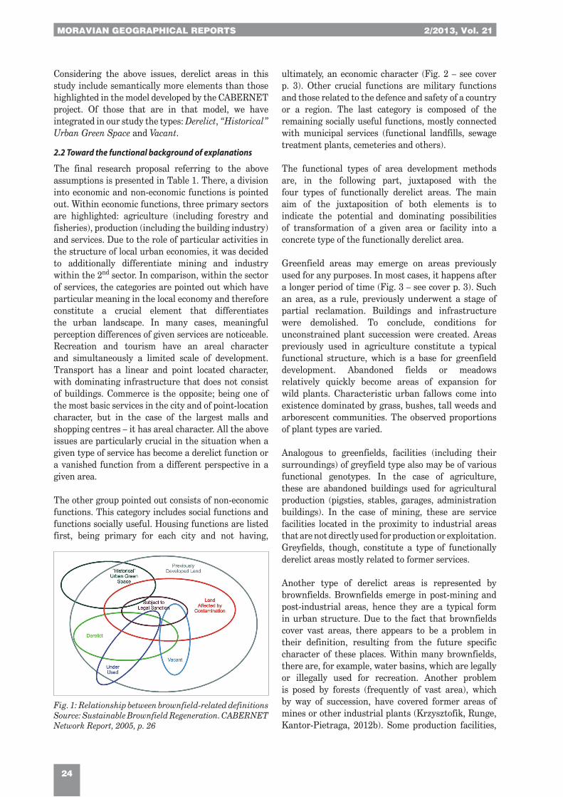
The range of problems connected with understanding the term of brownfields, also in its genetic and functional context, is reflected in Fig. 1, for example. In reference to the scope of human geography and its academic sub-disciplines, the authors indicate a need to refer to them in an attempt to create a dynamic and functional model of derelict areas. Therefore, this model includes:• the research subject for various academic sub-
disciplines of anthropogeography (human and social geography, settlement geography, agriculture geography, geography of industry, geography of services, geography of transport, geography of tourism, commercial geography, spatial aspects of all branches of geography);
• the time factor, creating the picture of development stages for a given fragment of space; and
• the specific locational conditioning factors, conditioned by functions in an urban system.
Tab. 1: Geographical typology of functionally derelict areas: previous functions versus dominant type Note: X – a key type of functionally derelict area for the function in question; x – other types of functionally derelict areas. [-] – relation not existing. Source: Authors
Former functional type of the concerned area Type of functional derelict area
Greenfields Greyfields Brownfields Blackfields
Economic functions
1st sector Agriculture X X - x
2nd sectorMining x X X x
Industry (& construction) x X X x
3rd sector
Logistics and comunication x X x x
Commercial x X - -
Recreation x X - -
Other services x X - x
Non-economic functions
Residential x X - -
Military x X x x
Other x X x x
MORAVIAN GEOGRAPHICAL REPORTS 2/2013, Vol. 21
24
Considering the above issues, derelict areas in this study include semantically more elements than those highlighted in the model developed by the CABERNET project. Of those that are in that model, we have integrated in our study the types: Derelict, “Historical” Urban Green Space and Vacant.
2.2 Toward the functional background of explanations
The final research proposal referring to the above assumptions is presented in Table 1. There, a division into economic and non-economic functions is pointed out. Within economic functions, three primary sectors are highlighted: agriculture (including forestry and fisheries), production (including the building industry) and services. Due to the role of particular activities in the structure of local urban economies, it was decided to additionally differentiate mining and industry within the 2nd sector. In comparison, within the sector of services, the categories are pointed out which have particular meaning in the local economy and therefore constitute a crucial element that differentiates the urban landscape. In many cases, meaningful perception differences of given services are noticeable. Recreation and tourism have an areal character and simultaneously a limited scale of development. Transport has a linear and point located character, with dominating infrastructure that does not consist of buildings. Commerce is the opposite; being one of the most basic services in the city and of point-location character, but in the case of the largest malls and shopping centres – it has areal character. All the above issues are particularly crucial in the situation when a given type of service has become a derelict function or a vanished function from a different perspective in a given area.
The other group pointed out consists of non-economic functions. This category includes social functions and functions socially useful. Housing functions are listed first, being primary for each city and not having,
ultimately, an economic character (Fig. 2 – see cover p. 3). Other crucial functions are military functions and those related to the defence and safety of a country or a region. The last category is composed of the remaining socially useful functions, mostly connected with municipal services (functional landfills, sewage treatment plants, cemeteries and others).
The functional types of area development methods are, in the following part, juxtaposed with the four types of functionally derelict areas. The main aim of the juxtaposition of both elements is to indicate the potential and dominating possibilities of transformation of a given area or facility into a concrete type of the functionally derelict area.
Greenfield areas may emerge on areas previously used for any purposes. In most cases, it happens after a longer period of time (Fig. 3 – see cover p. 3). Such an area, as a rule, previously underwent a stage of partial reclamation. Buildings and infrastructure were demolished. To conclude, conditions for unconstrained plant succession were created. Areas previously used in agriculture constitute a typical functional structure, which is a base for greenfield development. Abandoned fields or meadows relatively quickly become areas of expansion for wild plants. Characteristic urban fallows come into existence dominated by grass, bushes, tall weeds and arborescent communities. The observed proportions of plant types are varied.
Analogous to greenfields, facilities (including their surroundings) of greyfield type also may be of various functional genotypes. In the case of agriculture, these are abandoned buildings used for agricultural production (pigsties, stables, garages, administration buildings). In the case of mining, these are service facilities located in the proximity to industrial areas that are not directly used for production or exploitation. Greyfields, though, constitute a type of functionally derelict areas mostly related to former services.
Another type of derelict areas is represented by brownfields. Brownfields emerge in post-mining and post-industrial areas, hence they are a typical form in urban structure. Due to the fact that brownfields cover vast areas, there appears to be a problem in their definition, resulting from the future specific character of these places. Within many brownfields, there are, for example, water basins, which are legally or illegally used for recreation. Another problem is posed by forests (frequently of vast area), which by way of succession, have covered former areas of mines or other industrial plants (Krzysztofik, Runge, Kantor-Pietraga, 2012b). Some production facilities,
Fig. 1: Relationship between brownfield-related definitionsSource: Sustainable Brownfield Regeneration. CABERNET Network Report, 2005, p. 26
Vol. 21, 2/2013 MORAVIAN GEOGRAPHICAL REPORTS
25
formally operating within services connected with transportation, logistics and communication, and acting for the benefit of railway or road engineering, were also included in brownfield areas.
The last category includes blackfields, which, in majority, represent a consequence of industrial or mining activities. Contamination, which endangers human lives or well-being strongly influences components of the natural environment (atmosphere, surface and ground water, soil). It may also result from other business and non-business activities; e.g. from abandoned pesticide tanks or other chemicals in agriculture, insufficient safeguarding of abandoned municipal units dealing with utilization and sewage or waste storage, and also service buildings where laboratory work was conducted with the use of toxic and poisonous substances.
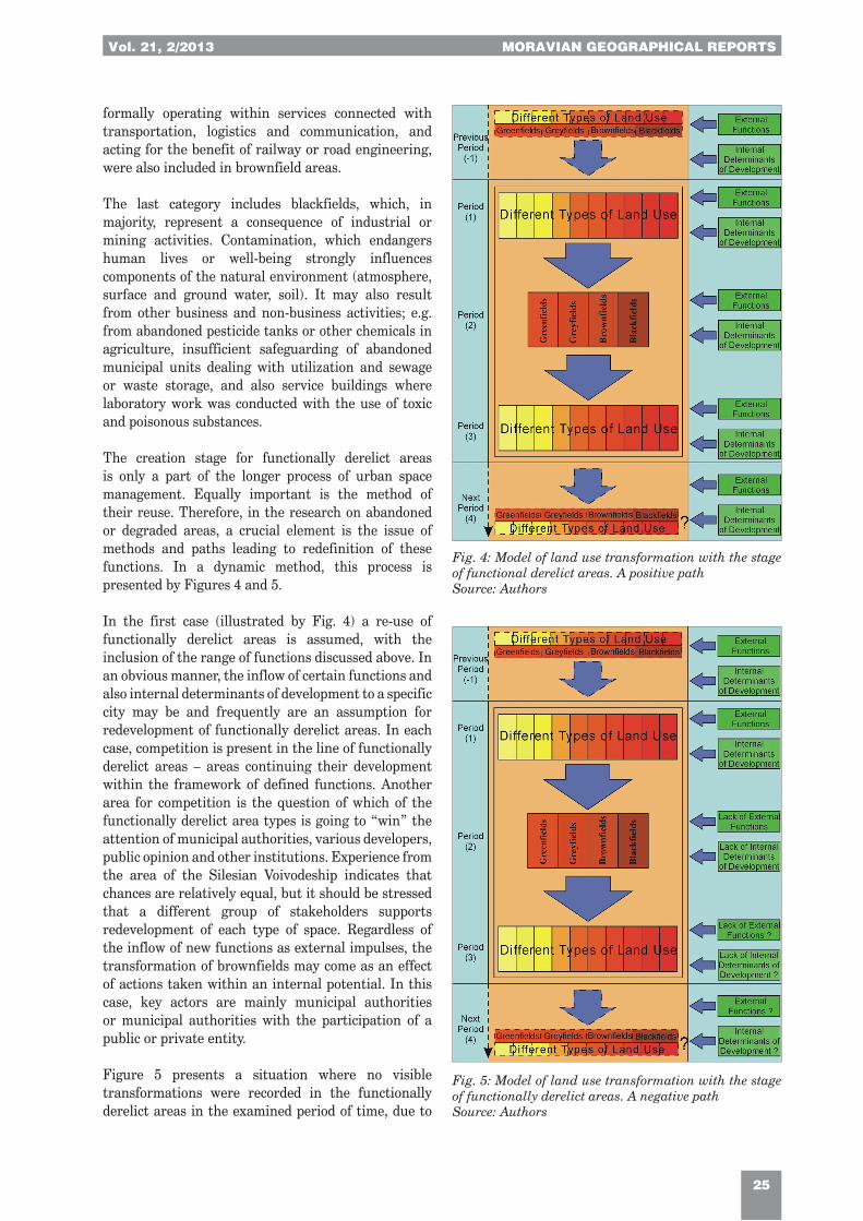
The creation stage for functionally derelict areas is only a part of the longer process of urban space management. Equally important is the method of their reuse. Therefore, in the research on abandoned or degraded areas, a crucial element is the issue of methods and paths leading to redefinition of these functions. In a dynamic method, this process is presented by Figures 4 and 5.
In the first case (illustrated by Fig. 4) a re-use of functionally derelict areas is assumed, with the inclusion of the range of functions discussed above. In an obvious manner, the inflow of certain functions and also internal determinants of development to a specific city may be and frequently are an assumption for redevelopment of functionally derelict areas. In each case, competition is present in the line of functionally derelict areas – areas continuing their development within the framework of defined functions. Another area for competition is the question of which of the functionally derelict area types is going to “win” the attention of municipal authorities, various developers, public opinion and other institutions. Experience from the area of the Silesian Voivodeship indicates that chances are relatively equal, but it should be stressed that a different group of stakeholders supports redevelopment of each type of space. Regardless of the inflow of new functions as external impulses, the transformation of brownfields may come as an effect of actions taken within an internal potential. In this case, key actors are mainly municipal authorities or municipal authorities with the participation of a public or private entity.
Figure 5 presents a situation where no visible transformations were recorded in the functionally derelict areas in the examined period of time, due to
Fig. 4: Model of land use transformation with the stage of functional derelict areas. A positive pathSource: Authors
Fig. 5: Model of land use transformation with the stage of functionally derelict areas. A negative pathSource: Authors

MORAVIAN GEOGRAPHICAL REPORTS 2/2013, Vol. 21
26
the lack of inflow of functions within urban borders and the lack of initiatives from urban authorities or other actors.
The presented examples are of a model character. In the first case, we assume that transformations are going to reach any level of the new form of development. In the second case, that it is not going to happen at all. The reality shows that some changes occurred in almost all medium-size towns and cities in Poland researched by the authors (44 cases). In all of them the changes were not sufficient, but for the majority, not always desired or expected.
The model pointed out above is of a two-stage character, i.e. it defines the stage of emergence of a functionally derelict area [Period (1) to Period (2)] and its possible development or lack of it [Period (2) to (Period (3)]. Comprehensive explanation of these transformations will make it possible to have a broader analysis of the given area. That is, on the one hand, it allows one to refer to the stage of primary land use [Previous Period], before the function analysed presently as derelict was shaped there. It is particularly interesting if this function had not been shaped in a previous derelict area with, e.g. the 19th century genesis. Other former functional changes are also interesting.
On the other hand, the model reveals the necessity for academic research regarding further spatial and functional transformations in the future [Next Period]. This is particularly the case if the instability of a new way of development is observed or there are barriers which might have some influence on it in the nearest future, e.g. profitability of some industrial or service branches, free interpretation of the local spatial development plan, etc.
3. Derelict areas in Sosnowiec and the form of their development in the period 1990–2012
3.1 Downsizing of the economic base of Sosnowiec and its consequences
Sosnowiec is one of the largest cities in the Katowice conurbation and in the Upper-Silesian Industrial Region. It experienced an almost historic cycle of redefining its functions in the last two decades, which, for the first time since the establishment of the city in 1902, transformed from industrial to service and industrial. In the background of the transformation of the city’s functional image, there were serious economic, social, spatial or infrastructural problems. Sosnowiec is a large central-European city, which is ranked as a leading city as most affected by the political and economic transformation at the turn of the 1980s
and 1990s. On the other hand, it constitutes a model example of multi-aspect shrinkage (Krzysztofik, Runge, Kantor-Pietraga, 2012a).
In the period 1990–2012, as many as three out of four coalmines were closed down in the city and in one coalmine the number of employees was cut by half. Significant restructuring also took place in the two local ironworks. The huge centre of textile and clothing almost totally collapsed, including three of the largest facilities which had employed several thousand people before 1990. A large number of metal and machinery facilities were reduced. The functional crisis affected services as well, even local agriculture. In the period of 1990–2012, the city lost over 40 thousand inhabitants and this depopulation process continues. The demographic decline trend is going to prevail into the future. By 2035, the population of the city will have decreased to 160.8 thousand (from 215.3 thousand in 2010 and 259.4 thousand in 1990).
Another crucial consequence of the economic and social crisis of the city is the dynamic increase of brownfields, and to a lesser extent greyfields and derelict greenfields (Fig. 6).
Nevertheless, it should be highlighted here that since the early 2000s, a process of economic reorganization of the city is taking place, which has significantly slowed down the crisis, if not stopped it. A considerable success in redefining the function of the city was a concept, which stressed the need for developing local wastelands. Urban policy was focused on regaining
Fig. 6: Functionally derelict areas in the south districts of Sosnowiec, 1990–2012Source: Authors

Vol. 21, 2/2013 MORAVIAN GEOGRAPHICAL REPORTS
27
post-mining and post-industrial areas for economic purposes. Coming to terms with a not always “reasonable” pace of closing coalmines, decisions were taken to transform post-mining areas into new and diversified developments. Their character was described, depending on the specific location, as a new industry zone or a new industry and services zone. A significant role in the policy of eradicating brownfields in the city was played by the Katowice Special Economic Zone (KSEZ) and special programmes and tools endorsed by municipal authorities, such as The Economic Gateway of Silesia. Within the Katowice Special Economic Zone only, there emerged 13 new industrial facilities (Fig. 7). The sound investment policy with the simultaneous institutional and financial support, as well as individual actions of many entities, have enabled success to be reached within a dozen years, and this has not been experienced by any other city of similar size in Poland (Krzysztofik, Runge, Kantor-Pietraga, 2012a). Sosnowiec has become a leading town in the category of number and size of new investments per 10 thousand inhabitants,
and even a leader in the whole conurbation considering the corporate tax receipts from companies located in former brownfields. A positive aspect is also the number of employed persons. Companies of diverse branches located in the brownfields employ over four thousand persons.
The described phenomenon of the “economic” governance (municipal authorities, KSEZ, individual entrepreneurs, central government, EU) of the problem of brownfields is of permanent character. However, the effects of this policy are variables over time. The investment activities peaked in 2006–2010 and the number of developments has been decreasing currently. This is a result of the general world economic crisis as well as of the lack of municipal financial resources, which would be the city’s own contribution to build a new technical and transport infrastructure on the extensively developed brownfields so far (see Fig. 6 – large area marked in brown on the border of Bór, Dańdówka and Porąbka districts). An opportunity for the development of these areas is likely to be
Fig. 7: New investments in the derelict areas in the city of Sosnowiec, 1990-2012; a geographic-functional approach Explanations: 1 – borders of cities; 2 – borders of districts of Sosnowiec; 3 – main roads; TYPES OF NEW INVESTMENTS: 4 – industry or construction; 5 – industry with services; 6 – services (including: trade, logistics and others); 7 – residential functions; 8 – residential with services; PREVIOUS LAND USE: 9 – brownfields; 10 – greyfields; 11 – derelict greenfields; 12 – blackfields. City districts: I – Milowice; II – Stary Sosnowiec; III – Pogoń; IV – Środula; V – Sielec; VI – Śródmieście (Centrum); VII – Dębowa Góra; VIII – Dańdówka; IX – Klimontów; X – Zagórze; XI – Kazimierz Górniczy; XII – Porąbka; XIII – Ostrowy Górnicze; XIV – Maczki; XV – Bór; XVI – Niwka; XVII – Modrzejów; XVIII – Jęzor. Source: Authors

MORAVIAN GEOGRAPHICAL REPORTS 2/2013, Vol. 21
28
a new instrument of regional policy, the so-called OSI (Strategic Intervention Areas). The OSI will be financed from EU funds.
3.2 The “post-brownfield” landscape in Sosnowiec
The process of restructuring and closing industrial facilities in Sosnowiec resulted in a clear increase in the number and size of functionally derelict areas. From estimates, it is concluded that in the period from 1990 to 2010, their area increased by approximately 450 ha. This was additionally increased by wasteland areas that emerged in previous historical periods, even dating back to the second half of the 19th century. They were mostly areas connected with the former open-cast coal mining.
At the same time, in almost all city districts, single abandoned buildings appeared, or their fragments connected with services or trade. A majority of them were redeveloped relatively quickly. Some buildings though, especially the ones of large cubic volume, remained unoccupied. Some of them, such as the multi-storeyed Silesian University of Medicine in the Ostra Górka district, have not yet been completed. Former farmlands, where production has ceased, have constituted a peculiar category of derelict area. They were both privately-owned (Józefów, Porąbka, Kazimierz Górniczy), as well as state-owned (Sielec-Klimontów). In the Dańdówka district, abandoned gardens and orchards are noticeable.
Together with the emergence of successive wastelands, some of the formerly shaped ones were developed gradually. An increase in the dynamics of redeveloped areas took place in the 2nd half of the 1990s. Developers were mostly attracted to derelict greenfields or greyfields. New enterprises were mostly connected with large format commerce, services and housing development. A crucial element deciding on the location was the availability of convenient transport.
An investment breakthrough did not happen until after 2000, though. At that time, a transformation of economic structure in new investments took place. Industrial facilities began to dominate. Commerce and services became of secondary importance. Another crucial issue connected with that stage was the concentration of new investments in brownfields. This direction constituted a primary trend in the investment policy of the city as well as in the Katowice Special Economic Zone. Starting in 2000, the number of new industries grew rapidly. By 2009, 17 facilities were opened altogether, built from scratch (see Tabs. 2 and 3). Moreover, several smaller production companies (frequently established from the collapsed old ones) used the buildings and infrastructure of
closed-down facilities that operated in the socialist era. Since 2007, in the process of brownfields development, the dominating enterprises have been services. Some, such as the editorial office of a large regional newspaper and the most modern printing house in Central and Eastern Europe, Dziennik Zachodni (Polskapresse company) or the Exhibition Center Expo-Silesia, were particularly important investment points, also at the metropolitan scale.
The trend of dominating investments connected with services located in brownfields is confirmed by those realized in 2012, (Raben, the Silesian University of Medicine, the Sosnowiec Park of Science and Technology, the Climbing Centre – Poziom 450) as well as those under construction (see Tab. 4).
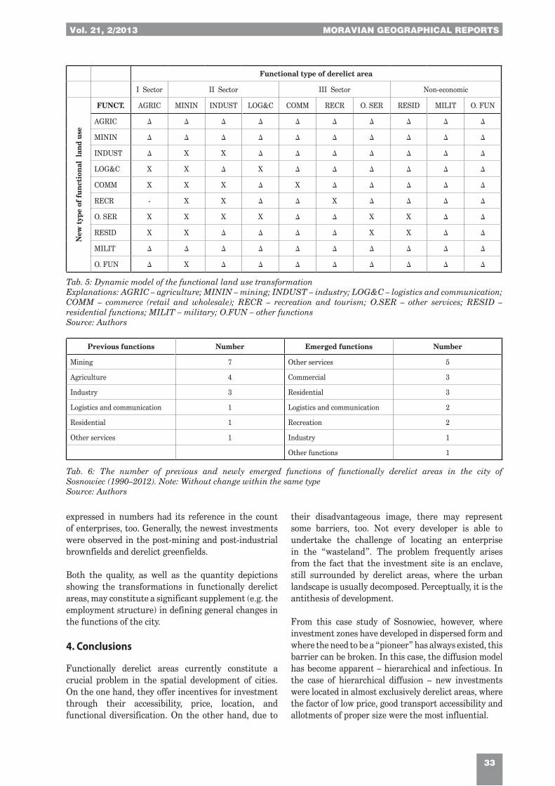
The awareness of the problem of development and location of functionally derelict areas in a given city and the scale of further investments in them allows for an empirical reference to the dynamic model previously proposed (Fig. 7). Table 5 presents a simplified version for the city of Sosnowiec. The simplification in this case lies in the fact that the “X” symbol indicates the existence of the functional transformation of the given arrangement and the “-” symbol indicates the lack of change. Instead of using symbols, one may enter for example a number of interactions of each type or the total area subjected to a functional transformation within the framework of particular functional types.
A complement to the model that makes the whole process legible comes in the form of a specification, indicating the dominating types of functionally derelict areas subject to disappearance in the space of a given city and the types of spatial development that are in their developmental stage (see Tab. 6). These specifications point out not only the method of making use of various types of functionally derelict areas, but they also may give evidence of the potential demand for them. From the academic point of view, they indicate the direction of general functional transformations in cities.
In the case of Sosnowiec, it is clearly noticeable that the regressive character in the structure of land use applies to former mining, agricultural and industrial areas. Their transformations went in the direction of several different functional types, but diverse from the previous ones. Only in some of the former post-industrial areas was this function recreated. Functionally derelict areas where the method of former use was different had an incidentally regressive character. An expansive character was typical for the following types: other services, commercial, and residential as well as logistics, transportation and industry. The scale of quality transformations

Vol. 21, 2/2013 MORAVIAN GEOGRAPHICAL REPORTS
29
No. Name of enterprise Function of enterprise Former land use type City part
1 Auchan Retail Der.gr. Środula
2 AUMA Polska Manufacture of metal products Der.gr. Zagórze
3 Banasik Wholesaling Wholesale Der.gr. Zagórze
4 Bodzio Meble Retail Der.gr. Zagórze
5 Brzozowy Stok (Osiedle) (The Birch Slope – H. Estate) Housing estate Der.gr. Sielec
6 Castorama Retail Der.gr. Zagórze
7 Decathlon Retail Der.gr. Środula
8 District motor vehicle inspection sta-tion Car service Der.gr. Zagórze
9 E. Leclerc Retail Der.gr. Zagórze
10 Ewmar-Ness Wholesale Der.gr. Zagórze
11 Ford – Szumilas Retail Der.gr. Zagórze
12 Leroy Merlin Retail Der.gr. Środula
13 Macro Cash&Carry Wholesale Der.gr. Zagórze
14 Mercedes Retail, wholesale & services Der.gr. Stary Sosnowiec
15 Mikołajczyka (Osiedle) (The Mikołajczyk – H. Estate) Housing estate Der.gr. Dębowa Góra
16 Municipal Rescue and Fire Department (Division Porąbka) Services Der.gr. Porąbka
17 Neuca Wholesale Der.gr. Zagórze
18 Norauto Retail & services Der.gr. Środula
19 ProLogis Sosnowiec Logistics Der.gr. Zagórze/Środula
20 Puczpol Manufacture, wholesale and service of metal products Der.gr. Klimontów
21 Słoneczne (Osiedle) (A Sunny – H. Estate) Housing estate Der.gr. Dębowa Góra/Sielec
22 Trade and Service Centre Retail, wholesale & services Der.gr. Sielec/Klimontów
23 Wzgórze (Osiedle) The Hill (H. Estate) Housing estate Der.gr. Sielec/Dębowa Góra
24 Toyota – Konsek Retail & services Der.gr. Zagórze
25 Volkswagen – Magro Retail & services Der.gr. Pogoń
26 Zielona Dolina (Osiedle) (The Green Valley – H. Estate) Housing estate Der.gr. Dańdówka
Tab. 2: New larger enterprises located in the derelict greenfields in Sosnowiec after 1990. Functions and localizationSource: Authors
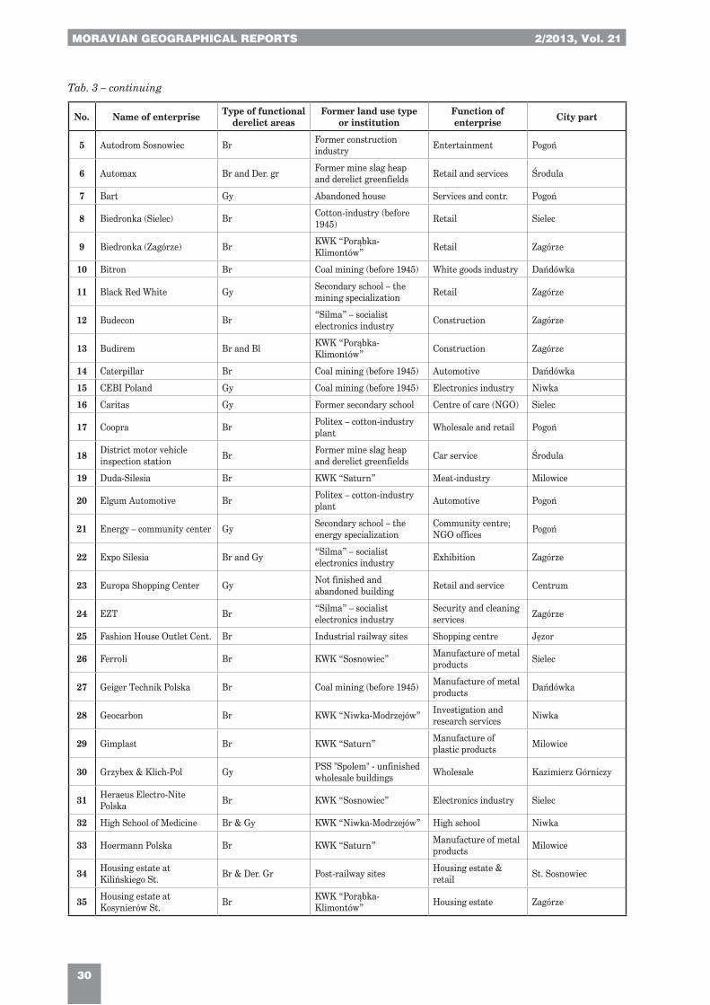
No. Name of enterprise Type of functional derelict areas
Former land use type or institution
Function of enterprise City part
1 Aldi (Pogoń) Br Meat industry Retail Pogoń
2 Aldi (Sielec) Br & Gy Post-mining railway sites Retail Sielec
3 Alicja Gy Abandoned community and entertainment center Services Ostrowy Górn.
4 Amtra Br Politex – cotton-industry plant Wholesale Pogoń
Tab. 3: Economic activities in Sosnowiec – the most important investments in brownfields and also in larger greyfields (as of 31.12.2012)Notes: Br – brownfields; Bl – blackfields; Der. gr – derelict greenfields; Gy – greyfields; KPP (Kopalnia Piasku Podsadzkowego) – Sand Pit; KWK (Kopalnia Węgla Kamiennego) – Hard Coal Mine; the authors considered both investments in new construction and new investments "in old walls" (refurbished buildings or objects)Source: Authors
MORAVIAN GEOGRAPHICAL REPORTS 2/2013, Vol. 21
30
No. Name of enterprise Type of functional derelict areas
Former land use type or institution
Function of enterprise City part
5 Autodrom Sosnowiec Br Former construction industry Entertainment Pogoń
6 Automax Br and Der. gr Former mine slag heap and derelict greenfields Retail and services Środula
7 Bart Gy Abandoned house Services and contr. Pogoń
8 Biedronka (Sielec) Br Cotton-industry (before 1945) Retail Sielec
9 Biedronka (Zagórze) Br KWK “Porąbka-Klimontów” Retail Zagórze
10 Bitron Br Coal mining (before 1945) White goods industry Dańdówka
11 Black Red White Gy Secondary school – the mining specialization Retail Zagórze
12 Budecon Br “Silma” – socialist electronics industry Construction Zagórze
13 Budirem Br and Bl KWK “Porąbka-Klimontów” Construction Zagórze
14 Caterpillar Br Coal mining (before 1945) Automotive Dańdówka
15 CEBI Poland Gy Coal mining (before 1945) Electronics industry Niwka
16 Caritas Gy Former secondary school Centre of care (NGO) Sielec
17 Coopra Br Politex – cotton-industry plant Wholesale and retail Pogoń
18 District motor vehicle inspection station Br Former mine slag heap
and derelict greenfields Car service Środula
19 Duda-Silesia Br KWK “Saturn” Meat-industry Milowice
20 Elgum Automotive Br Politex – cotton-industry plant Automotive Pogoń
21 Energy – community center Gy Secondary school – the energy specialization
Community centre; NGO offices Pogoń
22 Expo Silesia Br and Gy “Silma” – socialist electronics industry Exhibition Zagórze
23 Europa Shopping Center Gy Not finished and abandoned building Retail and service Centrum
24 EZT Br “Silma” – socialist electronics industry
Security and cleaning services Zagórze
25 Fashion House Outlet Cent. Br Industrial railway sites Shopping centre Jęzor
26 Ferroli Br KWK “Sosnowiec” Manufacture of metal products Sielec
27 Geiger Technik Polska Br Coal mining (before 1945) Manufacture of metal products Dańdówka
28 Geocarbon Br KWK “Niwka-Modrzejów” Investigation and research services Niwka
29 Gimplast Br KWK “Saturn” Manufacture of plastic products Milowice
30 Grzybex & Klich-Pol Gy PSS "Spolem" - unfinished wholesale buildings Wholesale Kazimierz Górniczy
31 Heraeus Electro-Nite Polska Br KWK “Sosnowiec” Electronics industry Sielec
32 High School of Medicine Br & Gy KWK “Niwka-Modrzejów” High school Niwka
33 Hoermann Polska Br KWK “Saturn” Manufacture of metal products Milowice
34 Housing estate at Kilińskiego St. Br & Der. Gr Post-railway sites Housing estate &
retail St. Sosnowiec
35 Housing estate at Kosynierów St. Br KWK “Porąbka-
Klimontów” Housing estate Zagórze
Tab. 3 – continuing
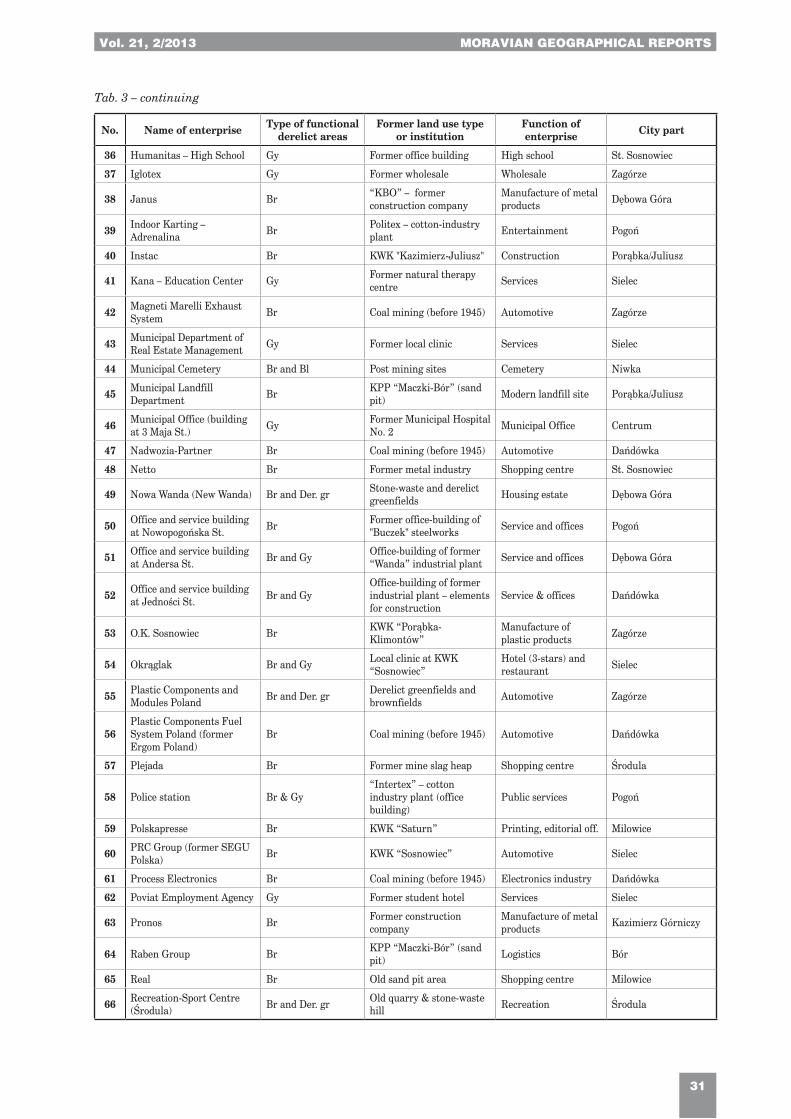
Vol. 21, 2/2013 MORAVIAN GEOGRAPHICAL REPORTS
31
No. Name of enterprise Type of functional derelict areas
Former land use type or institution
Function of enterprise City part
36 Humanitas – High School Gy Former office building High school St. Sosnowiec
37 Iglotex Gy Former wholesale Wholesale Zagórze
38 Janus Br “KBO” – former construction company
Manufacture of metal products Dębowa Góra
39 Indoor Karting – Adrenalina Br Politex – cotton-industry
plant Entertainment Pogoń
40 Instac Br KWK "Kazimierz-Juliusz" Construction Porąbka/Juliusz
41 Kana – Education Center Gy Former natural therapy centre Services Sielec
42 Magneti Marelli Exhaust System Br Coal mining (before 1945) Automotive Zagórze
43 Municipal Department of Real Estate Management Gy Former local clinic Services Sielec
44 Municipal Cemetery Br and Bl Post mining sites Cemetery Niwka
45 Municipal Landfill Department Br KPP “Maczki-Bór” (sand
pit) Modern landfill site Porąbka/Juliusz
46 Municipal Office (building at 3 Maja St.) Gy Former Municipal Hospital
No. 2 Municipal Office Centrum
47 Nadwozia-Partner Br Coal mining (before 1945) Automotive Dańdówka
48 Netto Br Former metal industry Shopping centre St. Sosnowiec
49 Nowa Wanda (New Wanda) Br and Der. gr Stone-waste and derelict greenfields Housing estate Dębowa Góra
50 Office and service building at Nowopogońska St. Br Former office-building of
"Buczek" steelworks Service and offices Pogoń
51 Office and service building at Andersa St. Br and Gy Office-building of former
“Wanda” industrial plant Service and offices Dębowa Góra
52 Office and service building at Jedności St. Br and Gy
Office-building of former industrial plant – elements for construction
Service & offices Dańdówka
53 O.K. Sosnowiec Br KWK “Porąbka-Klimontów”
Manufacture of plastic products Zagórze
54 Okrąglak Br and Gy Local clinic at KWK “Sosnowiec”
Hotel (3-stars) and restaurant Sielec
55 Plastic Components and Modules Poland Br and Der. gr Derelict greenfields and
brownfields Automotive Zagórze
56Plastic Components Fuel System Poland (former Ergom Poland)
Br Coal mining (before 1945) Automotive Dańdówka
57 Plejada Br Former mine slag heap Shopping centre Środula
58 Police station Br & Gy“Intertex” – cotton industry plant (office building)
Public services Pogoń
59 Polskapresse Br KWK “Saturn” Printing, editorial off. Milowice
60 PRC Group (former SEGU Polska) Br KWK “Sosnowiec” Automotive Sielec
61 Process Electronics Br Coal mining (before 1945) Electronics industry Dańdówka
62 Poviat Employment Agency Gy Former student hotel Services Sielec
63 Pronos Br Former construction company
Manufacture of metal products Kazimierz Górniczy
64 Raben Group Br KPP “Maczki-Bór” (sand pit) Logistics Bór
65 Real Br Old sand pit area Shopping centre Milowice
66 Recreation-Sport Centre (Środula) Br and Der. gr Old quarry & stone-waste
hill Recreation Środula
Tab. 3 – continuing
MORAVIAN GEOGRAPHICAL REPORTS 2/2013, Vol. 21
32
No. Name of enterprise Type of functional derelict areas
Former land use type or institution
Function of enterprise City part
67 Residential block at 11 Listopada St. Gy Abandoned hotel for
workers Residential function Dańdówka
68 Residential block at Czeladzka St. Gy Unfinished and abandoned
building Residential function Pogoń
69 Residential blocks at W. Polskiego St. Gy Unfinished and abandoned
buildings Residential function Dańdówka
70 Residental block at Mjr Hubala-Dobrzańskiego st. Gy Abandoned hotel for
workers Residential function Klimontów
71 Residential block at Kosynierów St. Gy Abandoned hotel for
workers Residential function Zagórze
72 Residential block at Mariacka St. Gy
“Metalowiec” – former community centre and cinema
Residential function Pogoń
73 Residential block at Sienkiewicza St. Gy Unfinished & abandoned
buildingResidential function and retail and services Centrum
74 Saltzgitter Mannesmann Br KPP “Maczki-Bór” (sand pit) Wholesale Bór
75 Selw-2 Br and Gy Steelwork “Buczek” Service and manufacture Środula
76 Silesian Logistics Centre Br Coal mining (before 1970) Logistics Jęzor
77 Silesian Revenue Office Gy Abandoned hotel for workers High school Dańdówka
78 Silesian University of Medicine Br Wasteland Administration Zagórze
79 Sistema Poland Br “Silma” – socialist electronics industry Wholesale Zagórze
80 Sosnowiec Park of Science and Technology Br KWK “Niwka-Modrzejów” Research
&Technology Niwka
81 Stelonex Br “Silma” – socialist electronics industry Logistics Zagórze
82 System Br “SPBP” – former contruction company
Furniture manufacture Dańdówka
83 Tesco (Sielec) Br Cotton-industry (before 1945) Retail Sielec
84 The Climbing Centre –Poziom 450 Br KWK “Sosnowiec” Recreation Sielec
85 The Jehovah’s Witnesses Convention Centre Br and Gy “Transgór” – former
logistics company Religious functions Niwka
86 TM Steel Br “SPBP” – former contruction company Wholesale Dańdówka
87 University of Silesia – Faculty of Philology Gy Abandoned old hospital High Education Pogoń
88 Watt Br Coal mining (before 1945) Engineering industry Niwka
89 Wrzosowe Ogrody (Heather Gardens) Br KWK “Sosnowiec” Housing estate Sielec
90 Zap Br and Der. gr Former mine slag heap and derelict greenfields Wholesale Środula
Tab. 3 – continuing
Tab. 4: Sosnowiec. Enterprises under construction (01.01.2013)Source: Authors
Name of enterprise
Function of enterprise Former land use type Former land use or
economic institution City part Will be open
Hotel Mercure Hotel Brownfields and Greyfields Mining power station Sielec 2013
Hotel ibis Style Hotel Brownfields Mining power station Sielec 2013
Kaufland Retail Brownfields Metal industry Stary Sosnowiec 2013
Vol. 21, 2/2013 MORAVIAN GEOGRAPHICAL REPORTS
33
Functional type of derelict area
I Sector II Sector III Sector Non-economic
New
typ
e of
fun
ctio
nal
lan
d us
e
FUNCT. AGRIC MININ INDUST LOG&C COMM RECR O. SER RESID MILIT O. FUN
AGRIC ∆ ∆ ∆ ∆ ∆ ∆ ∆ ∆ ∆ ∆
MININ ∆ ∆ ∆ ∆ ∆ ∆ ∆ ∆ ∆ ∆
INDUST ∆ X X ∆ ∆ ∆ ∆ ∆ ∆ ∆
LOG&C X X ∆ X ∆ ∆ ∆ ∆ ∆ ∆
COMM X X X ∆ X ∆ ∆ ∆ ∆ ∆
RECR - X X ∆ ∆ X ∆ ∆ ∆ ∆
O. SER X X X X ∆ ∆ X X ∆ ∆
RESID X X ∆ ∆ ∆ ∆ X X ∆ ∆
MILIT ∆ ∆ ∆ ∆ ∆ ∆ ∆ ∆ ∆ ∆
O. FUN ∆ X ∆ ∆ ∆ ∆ ∆ ∆ ∆ ∆
Tab. 5: Dynamic model of the functional land use transformationExplanations: AGRIC – agriculture; MININ – mining; INDUST – industry; LOG&C – logistics and communication; COMM – commerce (retail and wholesale); RECR – recreation and tourism; O.SER – other services; RESID – residential functions; MILIT – military; O.FUN – other functionsSource: Authors
Tab. 6: The number of previous and newly emerged functions of functionally derelict areas in the city of Sosnowiec (1990–2012). Note: Without change within the same typeSource: Authors
Previous functions Number Emerged functions Number
Mining 7 Other services 5
Agriculture 4 Commercial 3
Industry 3 Residential 3
Logistics and communication 1 Logistics and communication 2
Residential 1 Recreation 2
Other services 1 Industry 1
Other functions 1
expressed in numbers had its reference in the count of enterprises, too. Generally, the newest investments were observed in the post-mining and post-industrial brownfields and derelict greenfields.
Both the quality, as well as the quantity depictions showing the transformations in functionally derelict areas, may constitute a significant supplement (e.g. the employment structure) in defining general changes in the functions of the city.
4. Conclusions
Functionally derelict areas currently constitute a crucial problem in the spatial development of cities. On the one hand, they offer incentives for investment through their accessibility, price, location, and functional diversification. On the other hand, due to
their disadvantageous image, there may represent some barriers, too. Not every developer is able to undertake the challenge of locating an enterprise in the “wasteland”. The problem frequently arises from the fact that the investment site is an enclave, still surrounded by derelict areas, where the urban landscape is usually decomposed. Perceptually, it is the antithesis of development.
From this case study of Sosnowiec, however, where investment zones have developed in dispersed form and where the need to be a “pioneer” has always existed, this barrier can be broken. In this case, the diffusion model has become apparent – hierarchical and infectious. In the case of hierarchical diffusion – new investments were located in almost exclusively derelict areas, where the factor of low price, good transport accessibility and allotments of proper size were the most influential.
MORAVIAN GEOGRAPHICAL REPORTS 2/2013, Vol. 21
34
Following pioneer investments, new developments agglomerated around them in the process of a so-called infectious diffusion. From the perspective of over 20 years, it can be stated that this development model of functionally derelict areas, and particularly brownfields, is most welcome. It is recommended also from the viewpoint of economic, tax, social and spatial benefits.
The examined case of Sosnowiec also reveals that consistent and open urban policies focused on wasteland development may even create a model example of facing the problem for other post-mining and post-industrial cities. In Sosnowiec itself, a form of milieu has been shaped, which redefines the current development of the city.
References:ADAMSKI, T., OPRYCH, R. [eds.] (2012): Rewitalizacja terenów zdegradowanych a możliwości rozwoju regionu. Katowice,
Urząd Marszałkowski Województwa Śląskiego. 216 pp.
ALKER, S., JOY, V., ROBERTS, P., SMITH, N. (2000): The Definition of Brownfield. Journal of Environmental Planning and Management, Vol. 43, No. 1, p. 49–69.
FERBER, U., GRIMSKI, D., MILLAR, K., NATHANAIL, P. (2006): Sustainable Brownfield Regeneration: CABERNET Network Report. University of Nottingham, University Park, Nottingham, NG7 2RD, UK, 44 pp.
FRANZ, M., GÜLES, O, PREY, G. (2007): Place-making and “Green” Reuses of Brownfields in the Ruhr. Tijdschrift voor Economische en Sociale Geografie – 2008, Vol. 99, No. 3, p. 316–328.
FRANZ, M., PAHLEN, G., NATHANAIL, P.; OKUNIEK, N., KOJ, A. (2006): Sustainable development and brownfield regeneration – What defines the quality of derelict land recycling? Environmental Sciences Vol. 3, No. 2, p. 135–151.
GASIDŁO, K. (2010): Kierunki przekształceń przestrzeni przemysłu. Gliwice, Wydawnictwo Politechniki Śląskiej, 141 pp.
GASIDŁO, K., GORGOŃ, J. [eds.] (1999): Modelowe przekształcenia terenów poprzemysłowych i zdegradowanych. Katowice, UNDP POL, 175 pp.
GRIMSKI, D., FERBER, U. (2001): Urban brownfields in Europe. Land Contamination and Reclamation, Vol. 9, No. 1, p. 143–148.
HUDSON, R. (2005): Rethinking change in old industrial regions: reflecting on the experiences of North East England. Environment and Planning A, Vol. 37, No. 4, p. 581–596.
JARCZEWSKI, W. [ed.] (2009): Przestrzenne aspekty rewitalizacji. Śródmieścia, blokowiska, tereny poprzemysłowe, pokolejowe i powojskowe. Series: Rewiatalizacja Miast Polskich, Vol. 4. Kraków, Instytut Rozwoju Miast, 320 pp.
KOTLICKA, J. (2008): Przemiany morfologiczne terenów przemysłowych Łodzi. Łódź, Łódzkie Towarzystwo Naukowe, 233 pp.
KRZYSZTOFIK, R., RUNGE, J., KANTOR-PIETRAGA, I. (2012a): An Introduction to Governance of Urban Shrinkage. A Case of Two Polish Cities: Bytom and Sosnowiec. Sosnowiec, WNoZ, Uniwersytet Śląski, 129 pp.
KRZYSZTOFIK, R., RUNGE, J., KANTOR-PIETRAGA, I. (2012b): Paths of Environmental and Economic Reclamation: the Case of Post-Mining Brownfields. Polish Journal of Environmental Studies, Vol. 21, No. 1, p. 219–223.
KRZYSZTOFIK, R., RUNGE, J., KANTOR-PIETRAGA, I. (2012c): Governance of urban shrinkage: a tale of two Polish cities, Bytom and Sosnowiec, In: Churski, P. [ed.]: Contemporary Issues in Polish Geography. Bogucki Wydawnictwo Naukowe, Poznań, p. 201–224.
KIRKWOOD, N. [ed.] (2001): Manufactured Sites. Rethinking the Post-Industrial Landscape. London, New York, Taylor and Francis, 256 pp.
MORANCHO, A. B. (2003): A hedonistic valuation of urban green areas. Landscape and Urban Planning, Vol. 66, p. 35–41.
MŰLLER, B., FINKA, M., LINTZ, G. [eds.] (2005): Rise and Decline of Industry in Central and Eastern Europe. Berlin, Springer, 274 pp.
NATHANAIL, P., THORNTON, G., MILLAR, K. (2003): What’s in a Word: UK and international definitions of ‘brownfield’. Chapter 4.3: „MODEL 2: CABERNET A–B–C Model”, p. 43–45.
PIECH, M. (2004): Przemiany funkcjonalne terenów przemysłowych w latach 1988–1996. Łódź, Łódzkie Towarzystwo Naukowe, 212 pp.
POPESCU G., PĂTRĂŞCOIU R. (2012): Brownfields sites – between abandonment and redevelopment. Case study: Craiova city. Human Geographies – Journal of Studies and Research in Human Geography, Vol. 6, No. 1, p. 91–97.
SELLERS, G., MOFFAT, A. J., HUTCHINGS, T. R. (2006): Learning from experience: creating sustainable urban greenspaces from brownfield sites. In: Brebbia, C. A., Mander, U. [eds.]: Brownfields II. Prevention, Assessment, Rehabilitation and Development of Brownfield Sites, WIT Press, Southampton, p. 163–172.
Vol. 21, 2/2013 MORAVIAN GEOGRAPHICAL REPORTS
35
De SOUSA, C. A. (2008): Brownfields Redevelopment and the Quest for Sustainability. Current Issues in Urban and Regional Studies, Elsevier Publishing, London, 292 pp.
THORNTON, G., FRANZ, M., EDWARDS, D., PAHLEN, G., NATHANAIL, P. (2007): The challenge of sustainability: incentives for brownfield regeneration in Europe. Environmental science and policy, Vol. 10, No. 2, p. 116–134.
THORNTON, G., NATHANAIL, P., FRANZ, M., PAHLEN, G. (2007): The development of brownfield-specific sustainability and indicator framework for regenerating sites: proposing a new definition of “sustainable brownfield regeneration”. Land Contamination and Reclamation, Vol. 15, No. 1, p. 41–54.
TKOCZ, M., RILEY, R. (1999): Local respones to changed circumstances: coalmining in Upper Silesia, Geojurnal, Vol. 48, p. 279–290.
TOMERIUS S. (2000): Recycling Derelict Land in U.S. and German Cities – Transatlantic Sharing of Approaches, Strategies and Visions. Deutsches Institut für Urbanistik. Available at: www.difu.de/english/occasional/recycling.html.
VOJVODÍKOVÁ, B., POTUŽNÍK, M., BÜRGERMEISTEROVÁ, R. (2011): The database on brownfields in Ostrava (Czech Republic): some approaches to categorization. Moravian Geographical Reports, Vol. 19, No. 4, p. 50–60.
STANGEL, M. (2011): Transformation of Derelict Areas into Mixed-Use Urban Neighbourhoods – Case Studies in the Polish Cities. In: Schrenk, M., Popovich, V. V., Zeilie, P. [eds.]: Change for stability - lifecycles of cities and regions. Proceedings REAL CORP 2011. Essen, 18–20 May 2011, Essen, p. 1047–1052. Available at: http://corp.at/archive/CORP2011_138.pdf.
STEINER, M. (2003): Modernizing traditional industries in declining regions – Concepts of transformation in old and new market economies. In: Steiner, M. [ed.]: From old industries to new regions. Policies for structural transformations in accession countries. Graz, Leykam, p. 9–24.
Sustainable Brownfield Regeneration: CABERNET Network Report: Defining Brownfields: Scale and Nature. 2005. Available at: www.cabernet.org.uk/resourcefs/427.pdf.
TŐLLE, A., MUSZYŃSKA-JELESZYŃSKA, D., TADYCH, J, JASIŃSKA, M. (2009): Report about concepts and tools for brownfield redevelopment CENTRAL EUROPE Project 1CE084P4 COBRAMAN. Available at: www.cobraman-ce.eu.
WIRTH, P., ČERNIČ-MALI, B., FISCHER, W. [eds.] (2012): Post-Mining Regions in Central Europe – Problems, Potentials, Possibilities. Munich, Oekom Verlag, 269 pp.
www.environ.ie/en/Legislation/DevelopmentandHousing/Planning/FileDownLoad,25052.
www.umwelt.sachsen.de/umwelt/download/luft/CircUse_ToR_update.pdf.
Authors´ addresses:
Dr. Robert KRZYSZTOFIK, e-mail: [email protected]. Iwona KANTOR-PIETRAGA, e-mail: [email protected] SPÓRNA, M.SC., e-mail: [email protected] of Silesia, Department of Economic GeographyBędzińska street 60, 41-200 Sosnowiec, Poland
Initial submission 10 November 2012, final acceptance 10 April 2013
Please cite this article as:
KRZYSZTOFIK, R., KANTOR-PIETRAGA, I., SPÓRNA, T. (2013): A Dynamic Approach to the Typology of Functional Derelict Areas (Sosnowiec, Poland). Moravian Geographical Reports, Vol. 21, No. 2, p. 20–35.