1
North American Datum of 1983 (NAD 83) Universal Transverse Mercator, zone 12 FS-873-0403 The U.S. Department of Agriculture (USDA) prohibits discrimination in all its programs and activities on the basis of race, color, national origin, age, disability, and where applicable, sex, marital status, familial status, parental status, religion, sexual orientation, genetic information, political beliefs, reprisal, or because all or part of an individual's income is derived from any public assistance program. (Not all prohibited bases apply to all programs.) Persons with disabilities who require alternative means for communication of program information (Braille, large print, audiotape, etc.) should contact USDA's TARGET Center at (202) 720-2600 (voice and TDD). To file a compliant of discrimination, write to USDA, Director, Office of Civil Rights, 1400 Independence Avenue, S.W., Washington, D.C. 20250- 9410, or call (800) 795-3272 (voice) or (202) 720-6382 (TDD). USDA is an equal opportunity provider and employer. VICINITY MAP ID WY Pinedale Ranger District Bridger-Teton National Forest ) ! ! ! ! ! ! ! ! ! ! ! ! ! ! ! ! ! ! ! ! ! ! ! ! ! ! ! ! ! ! ! ! ! ! ! ! ! ! ! ! ! ! ! ! ! ! ! ! ! ! ! ! ! ! ! ! ! ! ! ! ! ! ! ! ! ! ! ! ! ! ! ! ! ! ! ! ! ! ! ! ! ! ! ! ! ! ! ! ! ! ! ! ! ! ! ! ! ! ! ! ! ! ! ! ! ! ! ! ! ! ! ! ! ! ! ! ! ! ! ! ! ! ! ! ! ! ! ! ! ! ! ! ! ! ! ! ! ! ! ! ! ! ! ! ! ! ! ! ! ! ! ! ! ! ! ! ! ! ! ! ! ! ! ! ! ! ! ! ! ! ! ! ! ! ! ! ! ! ! ! ! ! ! ! ! ! ! ! ! ! ! ! ! ! ! ! ! ! ! ! ! ! ! ! ! ! ! ! ! ! ! ! ! ! ! ! ! ! ! ! ! ! ! ! ! ! ! ! ! ! ! ! ! ! ! ! ! ! ! ! ! ! ! ! ! ! ! ! ! ! ! ! ! ! ! ! ! ! ! ! ! ! ! ! ! ! ! ! ! ! ! ! ! ! ! ! ! ! ! ! ! ! ! ! ! ! ! ! ! ! ! ! ! ! ! ! ! ! ! ! ! ! ! ! ! ! ! ! ! ! ! ! ! ! ! ! ! ! ! ! ! ! ! ! ! ! ! ! ! ! ! ! ! ! ! ! ! ! ! ! ! ! ! ! ! ! ! ! ! ! ! ! ! ! ! ! ! ! ! ! ! ! ! ! ! ! ! ! ! ! ! ! ! ! ! ! ! ! ! ! ! ! ! ! ! ! ! ! ! ! ! ! ! ! ! ! ! ! ! ! ! ! ! ! ! ! ! ! ! ! ! ! ! ! ! ! ! ! ! ! ! ! ! ! ! ! ! ! ! ! ! ! ! ! ! ! ! ! ! ! ! ! ! ! ! ! ! ! ! ! ! ! ! ! ! ! ! ! ! ! ! ! ! ! ! ! ! ! ! ! ! ! ! ! ! ! ! ! ! ! ! ! ! ! ! ! ! ! ! ! ! ! ! ! ! ! ! ! ! ! ! ! ! ! ! ! ! ! ! ! ! ! ! ! ! ! ! ! ! ! ! ! ! ! ! ! ! ! ! ! ! ! ! ! ! ! ! ! ! ! ! ! ! ! ! ! ! ! ! ! ! ! ! ! ! ! ! ! ! ! ! ! ! ! ! ! ! ! ! ! ! ! ! ! ! ! ! ! ! ! ! ! ! ! ! ! ! ! ! ! ! ! ! ! ! ! ! ! ! ! ! ! ! ! ! ! ! ! ! ! ! ! ! ! ! ! ! ! ! ! ! ! ! ! ! ! ! ! ! ! ! ! ! ! ! ! ! ! ! ! ! ! ! ! ! ! ! ! ! ! ! ! ! ! ! ! ! ! ! ! ! ! ! ! ! ! ! ! ! ! ! ! ! ! ! ! ! ! ! ! ! ! ! ! ! ! ! ! ! ! ! ! ! ! ! ! ! ! ! ! ! ! ! ! ! ! ! ! ! ! ! ! ! ! ! ! ! ! ! ! ! ! ! ! ! ! ! ! ! ! ! ! ! ! ! ! ! ! ! ! ! ! ! ! ! ! ! ! ! ! ! ! ! ! ! ! ! ! ! ! ! ! ! ! ! ! ! ! ! ! ! ! ! ! ! ! ! ! ! ! ! ! ! ! ! ! ! ! ! ! ! ! ! ! ! ! ! ! ! ! ! ! ! ! ! ! ! ! ! ! ! ! ! ! ! ! ! ! ! ! ! ! ! ! ! ! ! ! ! ! ! ! ! ! ! ! ! ! ! ! ! ! ! ! ! ! ! ! ! ! ! ! ! ! ! ! ! ! ! ! ! ! ! ! ! ! ! ! ! ! ! ! ! ! ! ! ! ! ! ! ! ! ! ! ! ! ! ! ! ! ! ! ! ! ! ! ! ! ! ! ! ! ! ! ! ! ! ! ! ! ! ! ! ! ! ! ! ! ! ! ! ! ! ! ! ! ! ! ! ! ! ! ! ! ! ! ! ! ! ! ! ! ! ! ! ! ! ! ! ! ! ! ! ! ! ! ! ! ! ! ! ! ! ! ! ! ! ! ! ! ! ! ! ! ! ! ! ! ! ! ! ! ! ! ! ! ! ! ! ! ! ! ! ! ! ! ! ! ! ! ! ! ! ! ! ! ! ! ! ! ! ! ! ! ! ! ! ! ! ! ! ! ! ! ! ! ! ! ! ! ! ! ! ! ! ! ! ! ! ! ! ! ! ! ! ! ! ! ! ! ! ! ! ! ! ! ! ! ! ! ! ! ! ! ! ! ! ! ! ! ! ! ! ! ! ! ! ! ! ! ! ! ! ! ! ! ! ! ! ! ! ! ! ! ! ! ! ! ! ! ! ! ! ! ! ! ! ! ! ! ! ! ! ! ! ! ! ! ! ! ! ! ! ! ! ! ! ! ! ! ! ! ! ! ! ! ! ! ! ! ! ! ! ! ! ! ! ! ! ! ! ! ! ! ! ! ! ! ! ! ! ! ! ! ! ! ! ! ! ! ! ! ! ! ! ! ! ! ! ! ! ! ! ! ! ! ! ! ! ! ! ! ! ! ! ! ! ! ! ! ! ! ! ! ! ! ! ! ! ! ! ! ! ! ! ! ! ! ! ! ! ! ! ! ! ! ! ! ! ! ! ! ! ! ! ! ! ! ! ! ! ! ! ! ! ! ! ! ! ! ! ! ! ! ! ! ! ! ! ! ! ! ! ! ! ! ! ! ! ! ! ! ! ! ! ! ! ! ! ! ! ! ! ! ! ! ! ! ! ! ! ! ! ! ! ! ! ! ! ! ! ! ! ! ! ! ! ! ! ! ! ! ! ! ! ! ! ! ! ! ! ! ! ! ! ! ! ! ! ! ! ! ! ! ! ! ! ! ! ! ! ! ! ! ! ! ! ! ! ! ! ! ! ! ! ! ! ! ! ! ! ! ! ! ! ! ! ! ! ! ! ! ! ! ! ! ! ! ! ! ! ! ! ! ! ! ! ! ! ! ! ! ! ! ! ! ! ! ! ! ! ! ! ! ! ! ! ! ! ! ! ! ! ! ! ! ! ! ! ! ! ! ! ! ! ! ! ! ! ! ! ! ! ! ! ! ! ! ! ! ! ! ! ! ! ! ! ! ! ! ! ! ! ! ! ! ! ! ! ! ! ! ! ! ! ! ! ! ! ! ! ! ! ! ! ! ! ! ! ! ! ! ! ! ! ! ! ! ! ! ! ! ! ! ! ! ! ! ! ! ! ! ! ! ! ! ! ! ! ! ! ! ! ! ! ! ! ! ! ! ! ! ! ! ! ! ! ! ! ! ! ! ! ! ! ! ! ! ! ! ! ! ! ! ! ! ! ! ! ! ! ! ! ! ! ! ! ! ! ! ! ! ! ! ! ! ! ! ! ! ! ! ! ! ! ! ! ! ! ! ! ! ! ! ! ! ! ! ! ! ! ! ! ! ! ! ! ! ! ! ! ! ! ! ! ! ! ! ! ! ! ! ! ! ! ! ! ! ! ! ! ! ! ! ! ! ! ! ! ! ! ! ! ! ! ! ! ! ! ! ! ! ! ! ! ! ! ! ! ! ! ! ! ! ! ! ! ! ! ! ! ! ! ! ! ! ! ! ! ! ! ! ! ! ! ! ! ! ! ! ! ! ! ! ! ! ! ! ! ! ! ! ! ! ! ! ! ! ! ! ! ! ! ! ! ! ! ! ! ! ! ! ! ! ! ! ! ! ! ! ! ! ! ! ! ! ! ! ! ! ! ! ! ! ! ! ! ! ! ! ! ! ! ! ! ! ! ! ! ! ! ! ! ! ! ! ! ! ! ! ! ! ! ! ! ! ! ! ! ! ! ! ! ! ! ! ! ! ! ! ! ! ! ! ! ! ! ! ! ! ! ! ! ! ! ! ! ! ! ! ! ! ! ! ! ! ! ! ! ! ! ! ! ! ! ! ! ! ! ! ! ! ! ! ! ! ! ! ! ! ! ! ! ! ! ! ! ! ! ! ! ! ! ! ! ! ! ! ! ! ! ! ! ! ! ! ! ! ! ! ! ! ! ! ! ! ! ! ! ! ! ! ! ! ! ! ! ! ! ! ! ! ! ! ! ! ! ! ! ! ! ! ! ! ! ! ! ! ! ! ! ! ! ! ! ! ! ! ! ! ! ! ! ! ! ! ! ! ! ! ! ! ! ! ! ! ! ! ! ! ! ! ! ! ! ! ! ! ! ! ! ! ! ! ! ! ! ! ! ! ! ! ! ! ! ! ! ! ! ! ! ! ! ! ! ! ! ! ! ! ! ! ! ! ! ! ! ! ! ! ! ! ! ! ! ! ! ! ! ! ! ! ! ! ! ! ! ! ! ! ! ! ! ! ! ! ! ! ! ! ! ! ! ! ! ! ! ! ! ! ! ! ! ! ! ! ! ! ! ! ! ! ! ! ! ! ! ! ! ! ! ! ! ! ! ! ! ! ! ! ! ! ! ! ! ! ! ! ! ! ! ! ! ! ! ! ! ! ! ! ! ! ! ! ! ! ! ! ! ! ! ! ! ! ! ! ! ! ! ! ! ! ! ! ! ! ! ! ! ! ! ! ! ! ! ! ! ! ! ! ! ! ! ! ! ! ! ! ! ! ! ! ! ! ! ! ! ! ! ! ! ! ! ! ! ! ! ! ! ! ! ! ! ! ! ! ! ! ! ! ! ! ! ! ! ! ! ! ! ! ! ! ! ! ! ! ! ! ! ! ! ! ! ! ! ! ! ! ! ! ! ! ! ! ! ! ! ! ! ! ! ! ! ! ! ! ! ! ! ! ! ! ! ! ! ! ! ! ! ! ! ! ! ! ! ! ! ! ! ! ! ! ! ! ! ! ! ! ! ! ! ! ! ! ! ! ! ! ! ! ! ! ! ! ! ! ! ! ! ! ! ! ! ! ! ! ! ! ! ! ! ! ! ! ! ! ! ! ! ! ! ! ! ! ! ! ! ! ! ! ! ! ! ! ! ! ! ! ! ! ! ! ! ! ! ! ! ! ! ! ! ! ! ! ! ! ! ! ! ! ! ! ! ! ! ! ! ! ! ! ! ! ! ! ! ! ! ! ! ! ! ! ! ! ! ! ! ! ! ! ! ! ! ! ! ! ! ! ! ! ! ! ! ! ! ! ! ! ! ! ! ! ! ! ! ! ! ! ! ! ! ! ! ! ! ! ! ! ! ! ! ! ! ! ! ! ! ! ! ! ! ! ! ! ! ! ! ! ! ! ! ! ! ! ! ! ! ! ! ! ! ! ! ! ! ! ! ! ! ! ! ! ! ! ! ! ! ! ! ! ! ! ! ! ! ! ! ! ! ! ! ! ! ! ! ! ! ! ! ! ! ! ! ! ! ! ! ! ! ! ! ! ! ! ! ! ! ! ! ! ! ! ! ! ! ! ! ! ! ! ! ! ! ! ! ! ! ! ! ! ! ! ! ! ! ! ! ! ! ! ! ! ! ! ! ! ! ! ! ! ! ! ! ! ! ! ! ! ! ! ! ! ! ! ! ! ! ! ! ! ! ! ! ! ! ! ! ! ! ! ! ! ! ! ! ! ! ! ! ! ! ! ! ! ! ! ! ! ! ! ! ! ! ! ! ! ! ! ! ! ! ! ! ! ! ! ! ! ! ! ! ! ! ! ! ! ! ! ! ! ! ! ! ! ! ! ! ! ! ! ! ! ! ! ! ! ! ! ! ! ! ! ! ! ! ! ! ! ! ! ! ! ! ! ! ! ! ! ! ! ! ! ! ! ! ! ! ! ! ! ! ! ! ! ! ! ! ! ! ! ! ! ! ! ! ! ! ! 600 713B 642 636A 670 680B 638A 640K 640C 671E 534 730 7699 680F 672B 640B 674B 7770 713A 680D 740 7770 7770A 600 ¬ « 352 650 680 660 661 617 741 670 609 696 630 625 759 632 615 612 637 664 610 611 658 605 640 684 (Loop) 647 614 743 607 627 762 649 711 631 534 647 740A 646 745 623 674C 766 747 622 674 751 648 608 636 712 688 666F 710 696 681 30680 671 638 769 651 730 693 756 621 672 643 628 676A 721 683 634 691 738 753 757 714 755 662 666D 686 713 637E 752 629 615B 618 682 735 689B 650 736 743A 616 663A 684C 685 612A 758 30420 637H 738H 748 641 605B 680H 746 613 664A 684F 680G 654 684A 763 698 665 738A 644 683D 744A 719 738B 674A 740B 635 646A 680I 692 630A 744 753G 680A 684D 753E 738C 604 640A 680C 732 736 676J 615C 753B 624 637D 751D 672A 637B 758B 753A 660C/D 758A 640J 683A 733 601A 660A 683F 630 610 763B 721A 683B 747A 738E 711A 676G 650 660 676 718 626 600 689 699 603 738 651A 600 660G 671A 753 718 740 717 666 683 0 663 660 680 716 666 620 615D 684E 601 768 767 768A 767A 610A 739 737 ¬ « 352 699 737A 762A 660E 661 666 666C 721B 622A 655 HALF MOON LAKE CG FREMONT LAKE C.G. TRAILS END CAMPGROUND Pinedale Daniel Junction Sunday Peak 5 " 9 " 9 " 9 " 9 " 9 " 9 " 9 109°45'0"W 109°45'0"W 109°52'30"W 109°52'30"W 110°0'0"W 110°0'0"W 110°7'30"W 110°7'30"W 109°30'0"W 109°30'0"W 109°37'30"W 109°37'30"W 43°30'0"N 43°30'0"N 43°22'30"N 43°22'30"N 43°15'0"N 43°15'0"N 43°7'30"N 43°7'30"N 43°0'0"N 43°0'0"N 42°52'30"N 42°52'30"N 570000 570000 580000 580000 590000 590000 600000 600000 610000 610000 620000 620000 4750000 4750000 4760000 4760000 4770000 4770000 4780000 4780000 4790000 4790000 4800000 4800000 4810000 4810000 4820000 4820000 See 'Green River Lakes Campground' Inset Map Willow Lake Fremont Lake Half Moon Lake GROS VENTRE WILDERNESS BRIDGER WILDERNESS Pinedale Ranger District Big Piney Ranger District Pinedale Ranger District Jackson Ranger District " 9 742 742B 742F 742A 742E 742C 742D 0 0.5 Miles Willow Lake Campground 751 751A 751B 751C 0 0.3 Willow Lake £ ¤ 89 £ ¤ 189 £ ¤ 191 £ ¤ 26 £ ¤ 89 £ ¤ 189 United States Department of Agriculture Forest Service WYOMING 2021 America's Great Outdoors National Forest Bridger-Teton Pinedale Ranger District, Use Map Motor Vehicle PURPOSE AND CONTENTS OF THIS MAP The designations shown on this motor vehicle use map (MVUM) were made by the responsible official pursuant to 36 CFR 212.51; are effective as of the date on the front cover of this MVUM; and will remain in effect until superceded by next year's MVUM. It is the responsibility of the user to acquire the current MVUM.This MVUM shows the National Forest System roads, National Forest System trails, and the areas on National Forest System lands in the Bridger-Teton National Forest that are designated for motor vehicle use pursuant to 36 CFR 212.51. This MVUM also identifies the vehicle classes allowed on each route and in each area; and any seasonal restrictions that apply on those routes and in those areas. Designation of a road, trail, or area for motor vehicle use by a particular class of vehicle under 36 CFR 212.51 should not be interpreted as encouraging or inviting use or implying that the road, trail, or area is passable, actively maintained, or safe for travel. Motor vehicle designations include parking along designated routes and at facilities associated with designated routes when it is safe to do so and when not causing damage to National Forest System resources. Seasonal weather conditions and natural events may render designated roads and trails impassable for extended periods. Designated areas may contain dangerous or impassable terrain. Many designated roads and trails may be passable only by high-clearance vehicles or four-wheel-drive vehicles. Maintenance of designated roads and trails will depend on available resources, and many may receive little maintenance. These designations apply only to National Forest System roads, National Forest System trails, and areas on National Forest System lands. ________________________________________ Forest Supervisor, Bridger-Teton National This motor vehicle use map identifies those roads, trails, and areas designated for the motor vehicle use under 36 CFR 212.51 for the purpose of enforcing the prohibition at 36 CFR 261.13. This is a limited purpose. The other public roads are shown for information and navigation purposes only and are not subject to designation under the Forest Service travel management regulation. PROHIBITIONS It Is prohibited to possess or operate a motor vehicle on National Forest System lands on the Bridger-Teton National Forest other than in accordance with these designations (CFR 261.13) Violators of 36 CFR 261.13 are subject to a fine of up to $5,000, imprisonment for up to 6 months, or both (18 U.S.C. 3571(e)).This prohibition applies regardless of the presence or absence of signs. This map does not display nonmotorized uses, over- snow uses, or other facilities and attractions on the Bridger-Teton National Forest. Obtain forest visitor information from the local national forest office. Designated roads, trails and areas may also be subject to temporary, emergency closures. As a visitor, you must comply with signs notifying you of such restrictions. A national forest may issue an order to close a road, trail or area on a temporary basis to protect the life, health, or safety of forest visitors or the natural or cultural resources in these areas. Such a temporary and/or emergency closures are consistent with the Travel Management Rule (36 CFR 212.52 (b), 36 CFR 261 subpart B). The designation "road or trail open to all motor vehicles" does not supersede State traffic law. INFORMATION SOURCES BRIDGER-TETON NATIONAL FOREST 340 North Cache P.O. Box 1888 Jackson, WY 83001 307-739-5500 PINEDALE RANGER DISTRICT 29 E. Fremont Lake Road P.O. Box 220 Pinedale, WY 82941 307-367-4326 BIG PINEY RANGER DISTRICT 10418 South Hwy 189 P.O. Box 218 Big Piney, WY 83113 307-276-3375 GREYS RIVER RANGER DISTRICT 671 North Washington Street Afton, WY 83110 307-886-5300 KEMMERER RANGER DISTRICT 308 Hwy 189 North Kemmerer, WY 83101 307-828-5100 JACKSON RANGER DISTRICT 25 Rosencrans Lane P.O. Box 1689 Jackson, WY 83001 307-739-5400 BLACKROCK RANGER DISTRICT P.O. Box 278 20250 East Hwy 26/287 Moran, WY 83013 307-543-2386 WYOMING GAME AND FISH DEP. Pinedale Office 432 E Mill Street Pinedale, WY 82941 307-367-4352 EMERGENCY PHONE NUMBERS Emergency Services................................911 Wyoming Highway Patrol.....1-800-442-9090 REPORT FIRES TO Ranger District Office or Fire Dispatch at 307-739-3630 www.fs.usda.gov/main/btnf/maps-pubs WEBSITE OPERATOR RESPONSIBILITIES Operating a motor vehicle on National Forest System roads, National Forest System trails, and in areas on National Forest System lands carries a greater responsibility than operating that vehicle in a city or other developed setting. Not only must you know and follow all applicable traffic laws, you need to show concern for the environment as well as other forest users. The misuse of motor vehicles can lead to the temporary or permanent closure of any designated road, trail, or area. As a motor vehicle operator, you are also subject to State traffic law, including State requirements for licensing, registration, and operation of the vehicle in question. Motor vehicle use, especially off-highway vehicle use, involves inherent risks that may cause property damage, serious injury, and possibly death to participants. Drive cautiously and anticipate rough surfaces and features, such as snow, mud, vegetation, and water crossings common to remote driving conditions. By your participation, you voluntarily assume full responsibility for these damages, risks, and dangers. Take care at all times to protect yourself and those under your responsibility. Much of the Bridger-Teton National Forest is remote. Medical assistance may not be readily available. Cellular telephones do not work in many areas of the Bridger-Teton National Forest. Take adequate food, water, first-aid supplies, and other equipment appropriate for the conditions and expected weather. ALWAYS REMEMBER TO RESPECT PRIVATE LAND! PROTECT YOUR PRIVILEGE. STAY ON DESIGNATED ROADS AND TRAILS AND IN DESIGNATED AREAS. Read and understand this map in its entirety. If you have questions, please contact the Bridger-Teton National Forest for clarification. As a motor vehicle operator on a National Forest System road, trail, or area you must comply with this map, as well as all Federal, State, and local laws and regulations. Compliance with these rules is your responsibility. This map and the other Bridger-Teton National Forest Motor Vehicle Use Maps are available for download at the website: www.fs.usda.gov/main/btnf/maps-pubs WEBSITE Seasonal Designation: This symbol, used in conjunction with one of the other road or trail symbols, indicates that the road or trail is open only during certain portions of the year. Refer to Seasonal and Special Designation Table for further instructions. Trails Open to Wheeled Vehicles 50" or less in Width: These trails are open only to wheeled, motor vehicles less than 50 inches in width at the widest point on the vehicle. Roads Open to Highway Legal Vehicles Only: These roads are open only to motor vehicles licensed under State law for general operation on all public roads within the state. EXPLANATION OF LEGEND ITEMS Trails Open to All Vehicles: These trails are open to all motor vehicles, including both highway legal and nonhighway legal vehicles. Special Vehicle Designation: This symbol indicates the road or trail is open to classes of vehicles other than those listed above. Refer to the Seasonal and Special Designation Table for further instructions. Roads Open to All Vehicles: These roads are open to all motor vehicles, including smaller off-highway vehicles that may not be licensed for highway use (but not to oversize or overweight vehicles under State traffic law). Short Route Identifier: This symbol is used for roads that are too short to show a symbol type on the map. The symbol contains the number of the road or trail. Users should refer to the corresponding number in the Short Route Table for designation information. 70333 Other Public Roads and Trails: These symbols are used to show routes the Forest Service does not have jurisdiction over and has not designated for motorized use. These symbols are part of the reference layers showing connections to towns and cities outside the forest boundary. Highways, U.S., State Other Public Roads Other Public Trails Legend ± 0 30 60 90 120 15 Miles 70333 Short Route Identifier Roads Open to Highway Legal Vehicles Roads Open to All Vehicles Trails Open to Wheeled Vehicles 50" or Less in Width Seasonal Designation (See Table) Highways, US, State Other Public Roads Peaks ) Forest or Unit Boundary National Forest System Lands Non-National Forest System Lands within the National Forest Wilderness Areas Political Boundary Lakes and Rivers Special Vehicle Designation (See Table) Burnt Lake £ ¤ 191 £ ¤ 189 191 ¬ « 354 See 'New Fork Lake Area' Inset Map 650 650A 650B 650C 650D Green River Lakes Campground Lower Green River Lakes Green River 0 0.1 0.2 0.3 Miles 741 749 749E 749 749G 749Q 749A 749F 749C 749J 749D 749I 749L Fremont Lake 0 0.5 1 Miles South Fremont Lake Area See 'South Fremont Lake Area' Inset Map FS Campground " 9 " 9 " 9 Whiskey Grove Campground Green River Lakes Mosquito Lake Fremont Lake Rd Skyline Drive Soda Lake / Willow Lake Rd Soda Lake Meadow Lake Little Half Moon Lake Fayette Lake Little Soda Lake New Fork Lake Rd Union Pass Road Forty Rod Road BRIDGER WILDERNESS Granite Lake Lake of the Woods Fish Lake Shoshone NF Rd 263 Union Pass £ ¤ 26 287 FITZPATRICK WILDERNESS (Shoshone NF) New Fork Lake Area ! ! ! ! ! ! ! ! ! ! ! ! ! ! ! ! ! ! ! ! ! ! ! ! ! ! ! ! ! ! ! ! ! ! ! ! ! ! ! ! ! ! ! ! ! ! ! ! ! ! ! ! ! ! ! ! ! ! ! ! ! ! ! ! ! ! ! ! ! ! ! ! ! ! ! ! ! ! ! ! ! ! ! ! ! ! ! ! ! ! ! ! ! ! ! ! ! ! ! ! ! ! ! ! ! ! ! ! ! ! ! ! ! ! ! ! ! ! ! ! ! ! ! ! ! ! ! ! ! ! ! ! ! ! ! ! ! ! ! ! ! ! ! ! ! ! ! ! ! ! ! ! ! ! ! ! ! ! ! ! ! ! ! ! ! ! ! ! ! ! ! ! ! ! ! ! ! ! ! ! ! ! ! ! ! ! ! ! ! ! ! ! ! ! ! ! ! ! ! ! ! ! ! ! ! ! ! ! ! ! ! ! ! ! ! ! ! ! ! ! ! ! ! ! ! ! ! ! ! ! ! ! ! ! ! ! ! ! ! ! ! ! ! ! ! ! ! ! ! ! ! ! ! ! ! ! ! ! ! ! ! ! ! ! ! ! ! ! ! ! ! ! ! ! ! ! ! ! ! ! ! ! ! ! ! ! ! ! ! ! ! ! " 9 " 9 " 9 730 738 735 736 738H 738A 733 738B 738D 738I 738C (Loop) 732 736A 736D 738E 736C 736B 731 730A 735 735A 730 730C 735B 732A 730B 730D 737A 738 736 0 1 2 0.5 Miles New Fork Lake New Fork Lake Campground New Fork Lake Group Campground Picnic Area " 5 Trail #7770 & #7770A are open to OHVs <= 64" wide Dispersed Camping Allowed ! ! ! ! ! ! ! ! Dispersed Camping Allowed: ! ! ! ! ! ! ! ! ! ! ! ! Motor vehicle use off of designated roads only for accessing dispersed campsites is permitted for up to 300 feet from the centerline of the road for the period of allowed use as shown on this map except in areas where there are Marked Designated Dispersed Sites.

A D S U S F OF THIS MAP G N I M O Y W - fs.usda.gov

  • Upload
    others

  • View
    2

  • Download
    0

Embed Size (px)

Citation preview

North American Datum of 1983 (NAD 83)Universal Transverse Mercator, zone 12FS-873-0403

The U.S. Department of Agriculture (USDA)prohibits discrimination in all its programsand activities on the basis of race, color,national origin, age, disability, and whereapplicable, sex, marital status, familialstatus, parental status, religion, sexualorientation, genetic information, politicalbeliefs, reprisal, or because all or part of anindividual's income is derived from anypublic assistance program. (Not allprohibited bases apply to all programs.)Persons with disabilities who requirealternative means for communication ofprogram information (Braille, large print,audiotape, etc.) should contact USDA'sTARGET Center at (202) 720-2600 (voiceand TDD). To file a compliant ofdiscrimination, write to USDA, Director,Office of Civil Rights, 1400 IndependenceAvenue, S.W., Washington, D.C. 20250-9410, or call (800) 795-3272 (voice) or (202)720-6382 (TDD). USDA is an equalopportunity provider and employer.

VICINITY MAPID WY

Pinedale Ranger

District

Bridger-TetonNational Forest

)

!

!

!!

!

!

!

!

!

!

!

!

!

!

!

!

!

!

!

!

!

!

!

!

!

!

!

!

!

!

!!

!

!

!

!

!!

!

!

!

!

!

!

!

!

!

!

!

!

!

!!

!

!

!

!

!

!

!

!!

!

!

!

!

!

! !

!

!

!

!

!

!

!

!

!

!

!

!

!

!

!

!

!

!

!

!

!

!

!

!

!

!

!!

!

!

! !

!

!

!

!

!

!

!

!

!

!

!

!

!

!

!

!!

!!

!

!

!

!

!

!!

!!

!

!

!

!

!!

!

!

!

!

!! !

!

!

!

!

!

!

!!

!

!

!

!

!

!

!

!!

!!

!!

!!

!

!!

!

!

!

!

!

!!

!

!!

!

!

!

!

!

!

!

!

!

!

!

!

!

!

!

!

!

!

!

!

!!

!

!

!

!

!

!

!

!!

!!

!!

!!

!

!!

!

!

!

!

!

!!

!

!!

!

!

!

!

!

!

!

!

!

!

!

!

!

!

!

!

!

!

!

!

!

!

! !

!!

! !

!

!

!

!

!

!

!

!

!

!

!

!

!

!

!

!

!

!

!

!

!

!

!

!

!

!

!

!

!

!

!

!

!

!

!

!

!!

!

!!

!!

!

!

!

!

!

!

!

!

!

!

!

!

!

!

!

!

!

!

!

!

!

!

!

!

!

!!

!

!!

!!

!!

!

!

!

!

!

!

!

!

!

!

!

!

!

!

!

!

!

!

!

!!

!

!

!

!

!

!

!

!!

!

!

!

!

!

!

!

!

!

!

!

!

!

!

!

!

!

!

!

!!

!

!

!

!

!!

!

!

!

!

!!

!

!

!

!

!

!

!

!

!

!

!

!

!

!

!

!!

!

!!

!

!

!

!

!

!

!

!

!!

!

!

!

!

!

!

!

!

!

!!

!

!

!

!

!

!

!

!

!

!

!

!

!

!

!

!

!

!

!

!

!

!

!

!

!

!

!

!

!

! !

!

!

! !

!

!

!

!

!

!

!

!

!

!

!

!

!

!

!

!!

!

!

!! !

!

! !

!!

!

!

!

!!

!

!

!

!

!

!

!

! ! !

!

!

!

!

!

!

!

!

!!

!

!

!

!!

!

!

!!!!

!!!

!

!

!!

!

!

!!

!

!

!

!

!

!

!!

!

!

!!

!!

!

!

!

!

!

!

!

!

!

!

!

!

!

!

!

!

!

!

!

!!

!

!

!

!

!

!

!!

!!

!

!

!!

!!

!

!

!

!

!

!

!

!

!

! !

!

!

!

!

!

!

!!

!

! !

!

!

!!

!

!

!

!

!

!

!

!

!

! !!

!

!

!

!

!

!

!

!!

!

!

!!

!!

!

!

!

!

!!

!

!

!!

!!

!

!

!

!

!

!

!

!

!

!

!

!

!

!

!

!

!

!

!

!!

!

!

!

!

!

!

!!

!!

!

!

!!

!!

!

!

!

!

!

!

!

!

!

!

!!

!

!

!

!

!!

!

!

!

!!

!

!!

!

!

!

!

!

!

!

!

!! !

!!

! !

!

!

!

!

!

!

!

!

!!

!

!

!

!

!

!

!

!

!

!

!

!

!

!

!

!!

!

!

!

!

!

!!

!

!

!

!

!!

!

!

!!

!

!

! !

!! !

!

!

!

!

!

!

!

!

!

!

!

!

!

!

!

!

!

!

! !

!

!

!!

!

!

!

!

!

!

!

!

!

!

!

!

!

!

!

!

!

!

!

!

!

!

!

!

!

!

!

!

!

!

!

!

!

!

!

!

!

!

!

!

!

!

!

!

!

!

!

!

!

!

!

!

!

!

!

!

!

!

!

!

!

!

!

!

!

!

!

!

!

!

!

!

!

!!

!!

!

!

!

!

!

!

!

!

!

!

!

!

!

!

!

!

!!

!!

!

!

!

!

!

!

!

!

!!

!

!

!

!

!

!

!

!

!

!

!

!

!

!

!

!

!

!

!

!

!

!

!

!

!

!

!

!

!

!

!

!

!!

!

!

!!

!

!

!

!

!

!

!

!

!

!

!

!

!!

!

!

!!

!

!

!

!

!

!

!

!

!

!

!

!

!

!

!

!!

!

!!

!!

!

!

!!

!

!

!

!

!

!

!

!

!

!

!

!

!

!

!

!

!

!

!!

!

!

!

!

!

!

!

!

!

!

! !

!

!

!

!

!

!

!

!!

!

!!

!

!

!!

!

!

!

!

!

!

!

!

!

!

!

!

!

!

!!

!

!

!

!

!

!!

!

!

!

!

!

!

!

!

!

!

!

!

!

!

!

!

!

!

!

!

!

!

!

!

!

!

!

!

!

!

!

!

!

!

!

!

!

!

!

!

!

!

!

!!

!

!

!

!!

!

!

!

!

!

!

!

!

!

!

!

!

!

!

!

!

!

!

!

!

!

!!

!!

!

!

!

!

! !!

!!

!

! !

!

!

!

!

!

!

!

!!

!

!

!

!

!

!

!

!

!

!

!

! !

!

!

!

!

!

!

!!

!

!

!!

!

!

!

!

!

!!

!

!

!

!

!

!

!

!!

!

!

!!

!

!

!

!

!

!!

!

!

!

! !

!

!!!

!

!!!

!

!

!

!

!

!

!!

!

!

!

!!

!

!

!

!

!

!!

!

!!

!

!!

!

!

!

!

!

!

!

!!

!

!!

!

!!

!

!

!

!

!

!

!

!

!!

!!

!

!

!!

!

! !

!

!!

!!

!

!

!

!

!

!

!

!!

!!

!

!

!! !

! !

!

!!

!!

!

!

!

!

!

!

!

!

!

!

!

!

!

!

!

!

!

!

!!

!

!

!

!

!

!

!

!!

!

!

!

!

!

!

!

!

!

!

!

!

!

!

!

!

!

!

!

!

!

!

!

!

!

!

!

!

!

!

!

!

!

!

!

!

!

!

!

!

!

!

!

!

!

!

!

!

!

!

!

!

!

!

!

!

!

!

!

!

!

!

!

!

!

!

!

!

!

!

!

!

!

!

!

!

!

!

!

!

!

!

!

! !

!

!

! !

!

!

!

!

!

!

!

!

!

!

!

!

!

!

!

!

!

!

!

!

!

!

!

!

!

!

!

!

!

!

!

!

!

!

!

!

!

!

!

!

!

!

!!

!

!

!

!

!

!!

!!

!

!

!

!

!

!

!

!

!

!!

!!

!!

!

!

!

!

!

!

!

!

!

!

!

!

!

!

!

!

!!

!

!

!

!!

!

!

!

!

!

!

!

!

!

!

!

!

!

!

!

!

!

!

!

!

!

!

!

!

!

!

!

!

!

!

!

!

!

!

!

!

!

!

!

!

!

!

!!

!

!!

!

!

!

!

!

!

!

!

!

!

!

!

!

!

!

!

!!

!

!

!

!

!!

!!

!

!

!!

!

!

!

!

!

!

!

!

!

!

!

!

!

!

!

!

!

!

!

!

!

!!

!

!

!!

!

!

!

!

!

!

!

!

!

!

!!

!

!

!

!!!

!

!

!

!

!

!

!

!

!

!

!

!

!

!

!

!

!

!

!

!

!

!

!

!!

!

!

!

!!!

!

!

!

!

!

!

!

!

!

!

!

!

!

!

!

!

!

!

!

!

!

!

!

!

! !

!

! !!

!

!

!

!!!

!

!!

!

!

!

!

!

!

!

!

!

!

!

!

!!

!

!

!!

!

!

!

!

!

!

!

!

!

!!

!

!

!!

!

!

!

!

!

!

!!

!

!!

!

!

!

!

!

!

!

!

!

!

!

!

!

!

!

!

!

!

! !

!

!

!

!

!!

!

!

!

!

!

!

!

!

!

!!

!!

!!

!

!

!

!

!!

!

!

!!

!

!

!

!

!

!

!

!

!

!

!

!

!

!

!

!

!

!

!

!

!

!

! !

! !

!

!

!

!

!

!

!

!

!

!

!

!

!

!

!

!

!

!

!

!

!

!

!

!

!

!

!

!!

!

!

!

!

!

!

!!

!

!

!

!

!

! !

!

!

!

!

!

!

!

!

!

!

!

!

!

!

!

!

!

!

!

!

!

!

!

!

!

!

!

!

!

!!

!

!

!!!

!

!

!

!

!!

!

!

!

!

!!

!

!

!

!!

!

!!!

!!

!

!!

!

! !

!

!

!

!

!

!

!

!

!

!

!

!

!

!

!

!

!

! !

!

!

!

! !

!

!!

!!

!

!

! !!

!

!

!

!

!

!

!

!

!

!

!

!

!

!!

!

! !

!!

!

!

!

!

!

!

!

!

!

!

!

!

!

!

!

!

!

!

!

!

!

!

!

!

!

!

!

!

!

!

!

!

!

!

!

!!

!

!!!

!

!

!

!!

!

!

!

!

!

!!

!

!

!

!

!

!

!

!

!

!

!

!

!

!

!

!

!

!

!

!

!

!

!

!

!

!

!

!

!

!

!

!

!

!

!

!

!

!

!

!

!

!

!

! !

!

!

!

!

!

!

!

!

!

!!

!!

!

!

!!

!

!

!

!

!

!

!

!

!! !

!

!

!

!

!

!

!

!

!

!

!

!

!

!

!

!

!!

!

!

!

!

!

!

!

!

!

!!

!

!

!

!

!

!

!

!

!!

!

!

!

!

!

!

!

!!

!

!

!

!

!

!

!

!

!

!

!

!

!!

!

!

!

!

!

!

!

!

!

!

!!

!

!

!!

!

!

!!

!

!!

!!

!

!

!

!

!

!!

!

!

!

!

!

!

!

!!

!!

!

!

!

!

!

!!

!

!

!

!!

!!

!

!

!

!!

!

!

!

!

!

!

!

!

!

!!

!

!!

!

!

!

!!

!

!!

!

!

!

!

!

!

!

!

!

!

!

!

!

!

!

!

!

!

!

!

!

!

!

!

!

!

!

!

!

!

!

!!

!

!

!

!

!

!

!!

!

!

!

!

!

!

!

!

!

!

!!

!

! !

!

!

!

!

!!

!

!

!

!!

!

!

!

!

!

!

!

!

!

!

!!

!

!

!

! !

!

!!

!

!!

!

!

!

!

!

!

!! !

!

! !

!

! !

!

!

!

!

!

!

!

!

!! !

!!

!

!

!

!

!!

!

!

!

!

!!

!

!

!

!

!

!

!

!

!

!

!

!

!

!

!

!

!

!

!

!

!

!

!

!

!

!

!

!

!

!

!

!

!

!

!

!

!

!

!

!

!

!

!

!!

!

!

!

!

!

!

!!

!

!

!

!

!

!

!

!

!

!

!

!

!!

!

!

!

!

!

!

!

!

!

!

!

!!

!

!

!

!

!

!

!

!

!

!

!

!

!

!

!

!

!

!

!

!

!

!!!

!

!!

!

!

!!

!

!

!

!

!

!

!

!

!

!

!

!

!

!

!

!

!!

!

!

!!

!

!!

!

!

!

!

!!

!

!

!!

!

!!

!

!

!

!

!

!

!

!

!

!

!

!

!

!

!

!

!

!

!

!

!

!

!

!

!

!

!

! !

!

!

!

!

!

!

!

!

!

!

!

!

!

!

!

!

!

!

!

!

!

!

!

!

!

!

!

!

!

!

!

!

!

!

!

!

!

!

!

!

!

!

!

!

!!

!

!

!

!

!

! !

!

!

! !

! !

!! !

!!

! !

!

!

!! !

!!

!

!

!

!

!

!!

!

!

!

!

!

!

!

!

!

!!

!

!

!

!

!

!!

!

! !

!

!

!

!

! !

!

!

!

!

!

!

!

!

!

!

!

!

600

713B

642

636A

670

680B

638A

640K

640C

671E

534

730

7699

680F

672B

640B

674B

7770

713A

680D

740

77707770A

600

¬«352

650

680

660

661

617

741

670

609

696

630

625

759

632

615

612

637

664

610

611

658

605

640

684 (Loop)

647

614

743

607

627

762

649

711

631

534

647

740A

646

745

623

674C

766

747

622

674

751

648

608

636

712

688

666F

710

696

681

30680

671638

769

651

730

693

756

621

672

643

628

676A

721

683

634

691

738

753

757

714

755

662666D

686

713

637E

752

629

615B

618

682

735

689B

650

736

743A

616

663A

684C

685

612A

758

30420

637H

738H

748

641

605B

680H

746

613

664A

684F 680G

654

684A

763

698

665

738A

644

683D

744A

719

738B

674A

740B

635

646A

680I

692

630A

744

753G

680A

684D

753E

738C

604

640A

680C

732

736

676J

615C

753B

624

637D

751D

672A

637B

758B75

3A

660C/D

758A

640J

683A

733

601A

660A

683F

630

610

763B

721A

683B

747A

738E

711A

676G

650

660

676

718

626

600

689

699

603

738

651A

600

660G

671A

753

718

740

717

666

683

30430

663

660

680

716

666

620

615D

684E

601

768

767

768A767A

610A739

737

¬«352

699

737A

762A

660E

661

666

666C

721B

622A655

HALFMOONLAKECG

FREMONTLAKEC.G.

TRAILS ENDCAMPGROUND

Pinedale

DanielJunction

SundayPeak

5

"9

"9

"9

"9

"9

"9

"9

109°45'0"W

109°45'0"W

109°52'30"W

109°52'30"W

110°0'0"W

110°0'0"W

110°7'30"W

110°7'30"W

109°30'0"W

109°30'0"W

109°37'30"W

109°37'30"W

43°30'0"N

43°30'0"N

43°22'30"N

43°22'30"N

43°15'0"N

43°15'0"N

43°7'30"N

43°7'30"N

43°0'0"N

43°0'0"N

42°52'30"N

42°52'30"N

570000

570000

580000

580000

590000

590000

600000

600000

610000

610000

620000

620000

4750000 4750000

4760000 4760000

4770000 4770000

4780000 4780000

4790000 4790000

4800000 4800000

4810000 4810000

4820000 4820000

See 'Green River LakesCampground' Inset Map

Willow Lake

Frem

ont L

ake

Half Moon Lake

GROS VENTREWILDERNESS

BRIDGERWILDERNESS

Pined

ale R

ange

r Dist

rict

Big Pi

ney R

ange

r Dist

rict

Pinedale Ranger

District

Jackson

Ranger District

"9

742

742B

742F

742A

742E

742C

742D

0 0.5Miles

Willow Lake Campground

751 751A751B

751C

0 0.3

Willow Lake

£¤89

£¤189£¤191

£¤26

£¤89

£¤189

United States Department of AgricultureForest Service

WYOMING 2021America's Great Outdoors

National ForestBridger-Teton

Pinedale Ranger District, Use MapMotor Vehicle

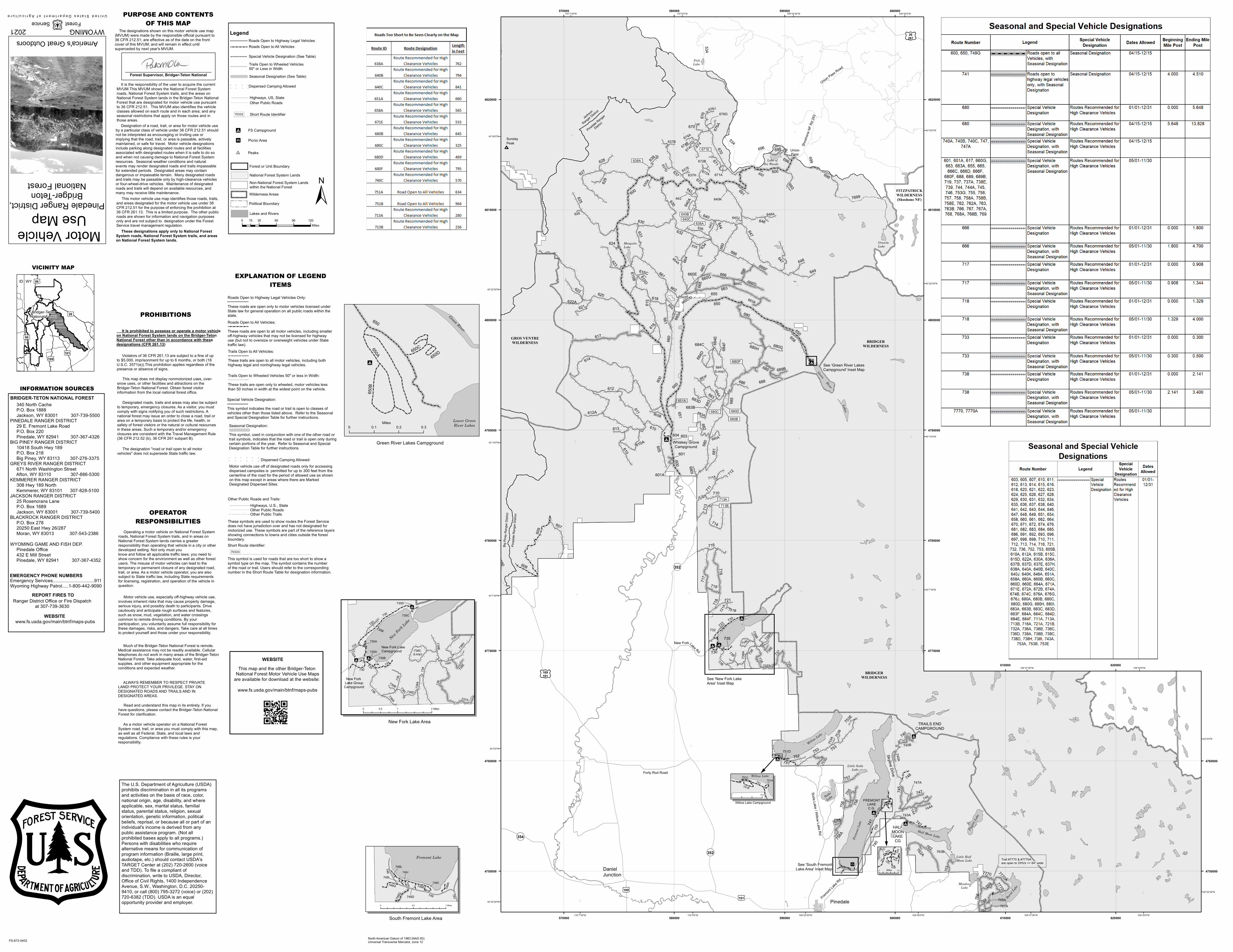
PURPOSE AND CONTENTSOF THIS MAP

The designations shown on this motor vehicle use map(MVUM) were made by the responsible official pursuant to36 CFR 212.51; are effective as of the date on the frontcover of this MVUM; and will remain in effect untilsuperceded by next year's MVUM.

It is the responsibility of the user to acquire the currentMVUM.This MVUM shows the National Forest Systemroads, National Forest System trails, and the areas onNational Forest System lands in the Bridger-Teton NationalForest that are designated for motor vehicle use pursuantto 36 CFR 212.51. This MVUM also identifies the vehicleclasses allowed on each route and in each area; and anyseasonal restrictions that apply on those routes and inthose areas. Designation of a road, trail, or area for motor vehicle useby a particular class of vehicle under 36 CFR 212.51 shouldnot be interpreted as encouraging or inviting use orimplying that the road, trail, or area is passable, activelymaintained, or safe for travel. Motor vehicle designationsinclude parking along designated routes and at facilitiesassociated with designated routes when it is safe to do soand when not causing damage to National Forest Systemresources. Seasonal weather conditions and naturalevents may render designated roads and trails impassablefor extended periods. Designated areas may containdangerous or impassable terrain. Many designated roadsand trails may be passable only by high-clearance vehiclesor four-wheel-drive vehicles. Maintenance of designatedroads and trails will depend on available resources, andmany may receive little maintenance.

These designations apply only to National ForestSystem roads, National Forest System trails, and areason National Forest System lands.

________________________________________Forest Supervisor, Bridger-Teton National

This motor vehicle use map identifies those roads, trails,and areas designated for the motor vehicle use under 36CFR 212.51 for the purpose of enforcing the prohibition at36 CFR 261.13. This is a limited purpose. The other publicroads are shown for information and navigation purposesonly and are not subject to designation under the ForestService travel management regulation.

PROHIBITIONS It Is prohibited to possess or operate a motor vehicleon National Forest System lands on the Bridger-TetonNational Forest other than in accordance with thesedesignations (CFR 261.13)

Violators of 36 CFR 261.13 are subject to a fine of upto $5,000, imprisonment for up to 6 months, or both (18U.S.C. 3571(e)).This prohibition applies regardless of thepresence or absence of signs.

This map does not display nonmotorized uses, over-snow uses, or other facilities and attractions on theBridger-Teton National Forest. Obtain forest visitorinformation from the local national forest office.

Designated roads, trails and areas may also be subjectto temporary, emergency closures. As a visitor, you mustcomply with signs notifying you of such restrictions. Anational forest may issue an order to close a road, trail orarea on a temporary basis to protect the life, health, orsafety of forest visitors or the natural or cultural resourcesin these areas. Such a temporary and/or emergencyclosures are consistent with the Travel Management Rule(36 CFR 212.52 (b), 36 CFR 261 subpart B).

The designation "road or trail open to all motorvehicles" does not supersede State traffic law.

INFORMATION SOURCESBRIDGER-TETON NATIONAL FOREST 340 North Cache P.O. Box 1888 Jackson, WY 83001 307-739-5500 PINEDALE RANGER DISTRICT 29 E. Fremont Lake Road P.O. Box 220 Pinedale, WY 82941 307-367-4326BIG PINEY RANGER DISTRICT 10418 South Hwy 189 P.O. Box 218 Big Piney, WY 83113 307-276-3375GREYS RIVER RANGER DISTRICT 671 North Washington Street Afton, WY 83110 307-886-5300KEMMERER RANGER DISTRICT 308 Hwy 189 North Kemmerer, WY 83101 307-828-5100JACKSON RANGER DISTRICT 25 Rosencrans Lane P.O. Box 1689 Jackson, WY 83001 307-739-5400BLACKROCK RANGER DISTRICT P.O. Box 278 20250 East Hwy 26/287 Moran, WY 83013 307-543-2386WYOMING GAME AND FISH DEP. Pinedale Office 432 E Mill Street Pinedale, WY 82941 307-367-4352

EMERGENCY PHONE NUMBERSEmergency Services................................911Wyoming Highway Patrol.....1-800-442-9090

REPORT FIRES TORanger District Office or Fire Dispatch

at 307-739-3630

www.fs.usda.gov/main/btnf/maps-pubsWEBSITE

OPERATORRESPONSIBILITIES

Operating a motor vehicle on National Forest Systemroads, National Forest System trails, and in areas onNational Forest System lands carries a greaterresponsibility than operating that vehicle in a city or otherdeveloped setting. Not only must youknow and follow all applicable traffic laws, you need toshow concern for the environment as well as other forestusers. The misuse of motor vehicles can lead to thetemporary or permanent closure of any designated road,trail, or area. As a motor vehicle operator, you are alsosubject to State traffic law, including State requirementsfor licensing, registration, and operation of the vehicle inquestion.

Motor vehicle use, especially off-highway vehicle use,involves inherent risks that may cause property damage,serious injury, and possibly death to participants. Drivecautiously and anticipate rough surfaces and features,such as snow, mud, vegetation, and water crossingscommon to remote driving conditions. By yourparticipation, you voluntarily assume full responsibility forthese damages, risks, and dangers. Take care at all timesto protect yourself and those under your responsibility.

Much of the Bridger-Teton National Forest is remote.Medical assistance may not be readily available. Cellulartelephones do not work in many areas of the Bridger-TetonNational Forest. Take adequate food, water, first-aidsupplies, and other equipment appropriate for theconditions and expected weather.

ALWAYS REMEMBER TO RESPECT PRIVATELAND! PROTECT YOUR PRIVILEGE. STAY ONDESIGNATED ROADS AND TRAILS AND INDESIGNATED AREAS.

Read and understand this map in its entirety. If youhave questions, please contact the Bridger-Teton NationalForest for clarification.

As a motor vehicle operator on a National ForestSystem road, trail, or area you must comply with this map,as well as all Federal, State, and local laws andregulations. Compliance with these rules is yourresponsibility.

This map and the other Bridger-Teton National Forest Motor Vehicle Use Maps

are available for download at the website: www.fs.usda.gov/main/btnf/maps-pubs

WEBSITE

Seasonal Designation:This symbol, used in conjunction with one of the other road ortrail symbols, indicates that the road or trail is open only duringcertain portions of the year. Refer to Seasonal and SpecialDesignation Table for further instructions.

Trails Open to Wheeled Vehicles 50" or less in Width:These trails are open only to wheeled, motor vehicles lessthan 50 inches in width at the widest point on the vehicle.

Roads Open to Highway Legal Vehicles Only:These roads are open only to motor vehicles licensed underState law for general operation on all public roads within thestate.

EXPLANATION OF LEGENDITEMS

Trails Open to All Vehicles:These trails are open to all motor vehicles, including both highway legal and nonhighway legal vehicles.

Special Vehicle Designation:This symbol indicates the road or trail is open to classes ofvehicles other than those listed above. Refer to the Seasonaland Special Designation Table for further instructions.

Roads Open to All Vehicles:These roads are open to all motor vehicles, including smalleroff-highway vehicles that may not be licensed for highway use (but not to oversize or overweight vehicles under Statetraffic law).

Short Route Identifier:

This symbol is used for roads that are too short to show asymbol type on the map. The symbol contains the numberof the road or trail. Users should refer to the correspondingnumber in the Short Route Table for designation information.

70333

Other Public Roads and Trails:

These symbols are used to show routes the Forest Servicedoes not have jurisdiction over and has not designated formotorized use. These symbols are part of the reference layersshowing connections to towns and cities outside the forestboundary.

Highways, U.S., StateOther Public RoadsOther Public Trails

Legend

±0 30 60 90 12015

Miles

70333 Short Route Identifier

Roads Open to Highway Legal VehiclesRoads Open to All Vehicles

Trails Open to Wheeled Vehicles 50" or Less in WidthSeasonal Designation (See Table)

Highways, US, StateOther Public Roads

Peaks)Forest or Unit BoundaryNational Forest System LandsNon-National Forest System Landswithin the National ForestWilderness Areas

Political Boundary

Lakes and Rivers

Special Vehicle Designation (See Table)

Burnt L

ake

£¤191

£¤189191

¬«354

See 'New Fork LakeArea' Inset Map

650

650A

650B

650C650D

Green River Lakes Campground

Lower GreenRiver Lakes

Green River

0 0.1 0.2 0.3Miles

741

749

749E

749749G

749Q 749A

749F 749C

749J

749D

749I

749L

Fremont Lake

0 0.5 1 Miles

South Fremont Lake Area

See 'South FremontLake Area' Inset Map

FS Campground"9

"9

"9 Whiskey GroveCampground

Green River

Lakes

MosquitoLake

Fremont

Lake R

d

Skyline Drive

Soda Lake / Willow Lake Rd

SodaLake

MeadowLake

Little Half Moon Lake

Fayet

te Lak

e

Little SodaLake

New ForkLake Rd

Union Pass Road

Forty Rod Road

BRIDGERWILDERNESS

GraniteLake

Lake of the Woods

FishLake

Shos

hone

NF R

d 263

UnionPass

£¤26287

FITZPATRICKWILDERNESS(Shoshone NF)

New Fork Lake Area

Narrows Campground

!

!

!

!

!

!

!

!

!

!!

!

!

!!

!

!

!

!

!

!

!

!

!

!

!

!

!

!

!

!

!

!

!

!

!

!

!

!

!

! ! !

!

!

!

! !!

!

!

!!

!

!

!

!

!

!

!

!

!

!

!

!

!

!

!

!!

!

!!

!!

!!

!

!!

!

!

!

!

!

!

!

!

!

!

!

!!

!

!

!

!

!

!

!!

!

!

!

!

!!

!

!

!

!

!

!

!

!

!

!!

!

!

!

!!

!

!

!

!

!

!

!

!

!

!

! !

!

!

!

!

!

!!!!

!

! !

!

!

!

!

!

!

!

!

!

!

!!

!

! !

!

!

!

!

!

!

!

!

!

!

!

!

!

!

!

!

!

!

!

!

!!

!!

!

!

!

!

!

!

!

!

!

!

!

!

!

!

!

!

!

!

! !

!!

!

!

!

!

!

!

!

!

!

!

!

!

!

!

!

!

!

!

!

!

!

!

!

!

!

!

!

!

!

!

!

!

!

!!

!

!

!

!

!

!

!

!!

!

!

!

!

!!

!

!

!!

!

!

!

!

!

!

!

!

!!

!

!

!! !

!

!

!

!

!

!

!

!

!

!

!

!

!

!

!

!

!

!

!

!

!

!

!

!

!

!

!

!

!

!

!

!

!

!

!

!

!

!

!!

!

!

!

!

!

"9

"9

"9

730

738735

736

738H

738A

733

738B

738D

738I

738C(Loop)

732

736A

736D

738E

736C

736B

731

730A

735

735A

730

730C

735B

732A

730B

730D

737A

738

736

0 1 20.5 Miles

New Fork Lake

New Fork Lake Campground

New Fork Lake Group

Campground

Picnic Area"5

Trail #7770 & #7770Aare open to OHVs <= 64" wide

Dispersed Camping Allowed! ! ! !

! ! ! !

Dispersed Camping Allowed:! ! ! ! ! !

! ! ! ! ! !

Motor vehicle use off of designated roads only for accessing dispersed campsites is permitted for up to 300 feet from the centerline of the road for the period of allowed use as shownon this map except in areas where there are Marked Designated Dispersed Sites.