Embed Size (px)
Citation preview

Developing Country Studies www.iiste.org
ISSN 2224-607X (Paper) ISSN 2225-0565 (Online)
Vol.4, No.5, 2014
66
A Critical Review of the Application of Planning Standards and Norms in the Planning of Bahir Dar and Hawassa Cities, Ethiopia
Mulugeta Worku Fetene (Corresponding author)∗
School of Graduate studies, Ethiopian Civil Service University, PO box 5648, Addis Ababa Ethiopia
Tel: +251 911907686 E-mail: [email protected]
Professor Kwame C Serbeh-Yiadom ∗∗
School of Graduate studies, Ethiopian Civil Service University, PO box 5648, Addis Ababa Ethiopia
Tel: +251 910124883 E-mail: [email protected]
Professor Melesse Asfaw ∗∗∗ School of Graduate studies, Ethiopian Civil Service University, PO box 5648, Addis Ababa Ethiopia
Tel: +251 935015427 E-mail: [email protected]
This Article is financed by the Ethiopian Civil Service University
Abstract The article evaluates the application of planning standards and norms in the 2006/7 Integrated Development Plan (IDP) of Bahir Dar and Hawassa Cities. Although planning standards and norms meant to standardize urban land use and function across urban centers of the country have been in existence at the Federal level since 2005, later revised in 2012, their implementation at the city level has not always been as required. This is a review of how the IDP’s of Bahir Dar and Hawassa Cities were prepared and have since performed, taking into account the planning standards and norms of the country. The findings expose gaps between what avails as rules and regulations of planning in Ethiopia and what is actual practice on ground in the two cities’ plan. In pursuance of the set objective, primary and secondary data was used. The primary data was collected from responses to questionnaires administered on selected households at the Kebele1 and Sub-city2 levels in Bahir Dar and Hawassa Cities, respectively. Secondary data used included the development planning schemes – IDPs - of the two cities, both the land use plan and the accompanying socio-economic report as well as the planning and zoning standard regulation of the country3. Other secondary data sources were relevant literature, proclamations4 and web-based information on urban planning in general. A descriptive-type analysis based on seven selected broad land use categories5 is used in comparing and contrasting the planning effectiveness of the two cities and to measure the extent of compliance with regulation. Based on the findings, it is concluded that a single broad land use category namely, infrastructure and transport complied and met the standard in both Bahir Dar and Hawassa Cities as required. The remaining six broad land use categories did not fit with the earmarked percentage proportions as per the standard for the respective land uses, and deviated by at least 25 percent and at most by 75 percent.
Key Words: Planning Standards and Norms, Land Use, Urban Plans, Structural Plan, Integrated Development Plan
∗ PhD candidate and lecturer in Urban Planning and Development at the Ethiopian Civil Service University, Addis Ababa. ∗∗ Associate Professor in Urban Planning and Development at the Ethiopian Civil Service University, Addis Ababa. ∗∗∗ PhD and PMP at the Ethiopian Civil Service University, Addis Ababa. 1 Kebele is the lowest administrative hierarchy accountable to the municipality in Bahir Dar 2 Sub-city is the lowest administrative hierarchy accountable to the municipality in Hawassa 3 Revised Standards for Structure Plan Preparation and Implementation, Addis Ababa 4 These are the laws – Acts, Decrees, etc., - passed from the Federal level of government 5 These categories are: housing, business & commerce, social services; green and recreation, sport & environmental; administrative ; and manufacturing and storage; infrastructure & transport

Developing Country Studies www.iiste.org
ISSN 2224-607X (Paper) ISSN 2225-0565 (Online)
Vol.4, No.5, 2014
67
I. Introduction
1.1. Conceptual Framework
The two cities whose urban planning standards and norms constitute the subject of this article are beneficiaries of the Integrated Development Plan (IDP) approach adopted in 2005 from South Africa. The IDP falls in the same category as strategic structural plans (Todes 2011) and hence it is important to shed light on its peculiarities as far as urban planning and processes are concerned. The term “urban planning’’ has been defined in many different ways. Whereas some consider it as an approach which utilizes directives on how land and land related subjects should be organized in a defined living space, others consider it as a process that promotes organization and learning (GTZ 1999).
Town planning is essentially concerned with shaping the future (Brook 2002, p.9; Ward 2004 ;), for one of the basic functions is the forecasting or projection of spatial patterns along with the location, density and intensity of land use (Todes 2011). Although rational ways of decision making about land use have traditionally occupied an important status in the planning process (Breheny and Hooper1985; Thomas 1994), the basis for the genesis of the urban planning movement as a radical reformist idea of improving the city begun in 1890 (Ward 2004, p.2) and encompasses the use, disposition, ownership and access to land (Kivell 2003). For others like GTZ (1999) apart from land reform, housing reform and the enhancement of community, the protection of amenities were considered as key factors. To give all these ideas a distinct identity, shape and coherence, the actual term town planning, although synonymously put with land use planning Kivell (2003), was coined almost certainly in 1905 (Ward 2004).
While spatial planning has recently become a generic term, each country has a name for its system of planning. For example, town and country planning (United Kingdom), physical planning (Sweden), land use planning (Ireland) Christou, et al (2006), urban planning (United States), and integrated development planning (South Africa). The aim of land use planning is directing and guiding the use of land and this will be so whether it is called land use planning, environmental planning, town and country planning, or urban and regional planning. Whereas this is true, there still remain questions as to what the limits of land use planning and the extent of its objectives are; is it aesthetic, efficiency, the assurance of equity, or sustainability? If all of these are objectives, how can they balance against each other to reflect optimum planning standards and norms? (Evans 2004, p. 1)
The ‘good governance’ agenda of international agencies like the World Bank and UN-Habitat have also spawned new interest in forms of integrated development planning in the context of decentralization of local government (Harrison 2006). Consequently, new forms of strategic spatial planning have emerged internationally as cities and regions attempt to adapt to economic restructuring and to the need to collaborate across growing city and regional linkages (Healy et al. 1997; Healey 2007).
As applied in urban planning, the term "norm" can be defined as a guideline of the social or institutional set of values which do shape and govern the behavioral pattern of society involving physical and social relations in a given space; while the term "standard" can also be defined as the level and quality of site planning and zoning, as it conforms with established land use policies and other regulations that would be required to make the built environment functional and desirable (MUDC,2012).
1.2. Background
In the context of Ethiopia the practice of modern urban planning is very recent though, it has experienced interesting transitions in approach from the conventional master planning to development planning, to action planning, to strategic structural planning, and to integrated development planning.
On the basis of policy, the government directed the country to adopt the integrated development planning from South Africa in 2006. The then Federal Urban Planning Institute (FUPI), in collaboration with regional counterparts RUPIs1, prepared plans for a number of cities in the country and the plans of Bahir Dar and Hawassa resulted from this initiative. The Integrated Development Planning (IDP) has been defined in local schemes2 as a process through which the municipalities prepare a strategic development plan, which guides and informs all the planning, budgeting, managing and decision-making in a municipality for a five year period. Since 2005, the Government enacted a proclamation decreeing that henceforth only Structural Plan, implemented
1 These include the Regional Urban Planning Institutes [RUPI] in the two regions, i.e. Southern Nations Nationalities People’s Regional State and Amhara Regional State. The RUPI in Amhara Regional State is still functional but the RUPI in SNNPRS is defunct. 2 The Bahir Dar Integrated Development Plan [BDIDP 2006 P.1] and Awash Integrated Development Plan [AIDP 2006.p.12]

Developing Country Studies www.iiste.org
ISSN 2224-607X (Paper) ISSN 2225-0565 (Online)
Vol.4, No.5, 2014
68
at the local level by an appropriate detailed Local Development Plan, be taken as the mandatory planning approach across urban centers of Ethiopia.
1.3. The problem The practice of preparing and implementing of urban plans of any type (development plan, master plan, structural plan, and integrated development plan) in Ethiopia is over 70 years. A little more than a third of the recognized1 urban centers in the country have plans for their development, although these plans are not uniform2 and the physical arrangement of land uses, infrastructure, and services lack acceptable norms and standard. To a large extent this problem emanates from failure of implementation of a uniform urban planning norms and standards across the country to help improve the efficiency of urban centers.
1.4. Objectives
The objective of this article is to evaluate the extent to which the 2006/7 integrated development plans (IDPs) of Bahir Dar and Hawassa conforms with or deviates from the approved permissible planning standards and norms as contained in the Revised Standards for Structure Plan Preparation and Implementation3. Cognizant of this, the specific objectives to be addressed include:
1. To evaluate existing and proposed land uses plans of the two cities against the planning standards and norms of the country; and
2. To analyze the level of consistency entailed in use of standards and norms in plan preparation of the two cities.
1.5 Hypothesis
H1: The distribution of land uses in Bahir Dar and Hawassa cities are depend on the planning standard
and norms of the country.
H0: The distribution of land uses in Bahir Dar and Hawassa cities not depend on the planning
standards and norms of the country.
1.6. Scope
The geographic scope of the study is defined by the urban planning limits of Bahir Dar and Hawassa. Thematically, the scope exclusively relies in analyzing the two cities plan vis-à-vis planning standards and norms. Time-wise, the study covers the planning period for the implementation of the IDP plans of the two cities.
1.7. Methodology
The article relies on both primary and secondary data sources. The primary data was collected from questionnaires administered on selected households in the two cities. Systematic sampling technique was used4 in the survey to select housing units/ buildings. In all, a total of 768 questionnaires were administered on households with an equal number of 384 in each of the two cities. The secondary data used were the planning schemes (including the socio-economic report and the land use plan) of the two cities and the planning and zoning standards of the Federation5. This is without ignoring the inclusion of literature review, proclamations and web-based sources.
The descriptive-type analysis was used to establish the peculiar characteristics of the two cities and the evaluation was made on the basis of the planning standards and norms of the country. The unit of analysis took
1 CSA 2007 census recorded 925 urban centers 2 Different plans were in use in the country (like the master plan, the development plan, the structure plan)
4 Sample was composed of selected housing units/ buildings at intervals of every 35th and 49th buildings in the seven sub-cities and nine kebeles of Hawassa and Bahir Dar respectively, into which the two cities were stratified. 5 Urban Planning Standards and Norms to standardize the urban development planning project efforts in the cities of the country.

Developing Country Studies www.iiste.org
ISSN 2224-607X (Paper) ISSN 2225-0565 (Online)
Vol.4, No.5, 2014
69
into account the land uses incorporated in the two cities respective planning schemes as analyzed based on the planning and zoning standards formerly developed by the then Ministry of Federal Affairs and later revised by the Ministry of Urban Development and Construction.
II. Discussion
2.1 Actual Proportion of Land Use Categories in the Urban Space
In broad terms the revised standard has set the minimum and maximum standards for seven general land use categories. These general land use categories are housing/residential; business & commercial centers and market places; social services (public facilities, cultural, archeological sites & special functions); green (recreation, sports and environmental sensitive area); administration; manufacturing &storage; and infrastructure & transport. A range of percentage land use share for each general category is stipulated in the standard as indicated below, though, the values fail to sum up to a total percentage figure of 100 in both the upper and lower limits. Nevertheless, it can still be used as a basis for preparing, implementing as well as evaluating plans and practices on the ground.
Table 1 also gives information on standards for the different categories against the plans of Bahir Dar and Hawassa Cities, for both existing and proposed land uses.
Table 1: Proportion of general land use classification as per the standard, BDIDP and AIDP
No Land use type % as per the standard *
Bahir Dar** Hawassa***
Existing Proposed Existing Proposed
1 Housing 40-50 26 22 37.69 27.25
2 Business & commerce /centers and market place
10-20 3 6 7.33 6.24
3 Social services (public facilities , cultural , archeological & special functions
10-20 18 28 16.89 16.35
4 Green, recreation, sport & environmental sensitive area
15-20 29 25 5.71 30.19
5 Administration 3-7 3 1 4.99 2.02
6 Manufacturing & storage 10-15 8 6 13.63 5.55
7 Infrastructure and transport 12-25 13 12 13.71 12.4
Source: *Ministry of Works and Urban Development (2006), **BDIDP (2006/7), *** AIDP (2006/7)
Taking the average of the standard values of the percentage proportion of land use for different categories, the following bar chart is produced to portray the extent of deviation and compliance. In the chart below, it is evident that the average land use values do not measure up to the stipulated standards. Again, it is clear that the contribution of administrative land use and business & commercial land use make up the lowest components of the city size in both cities. Similarly, the contribution of other land uses can be ascertained and compared between the cities.

Developing Country Studies www.iiste.org
ISSN 2224-607X (Paper) ISSN 2225-0565 (Online)
Vol.4, No.5, 2014
70
Graph 1: The average land use standard and the proportion the different land use in Bahir Dar & Hawassa
Source: Derived from table 1
Below is a detailed discussion of the seven land use categories as they feature in both the existing and the proposed plan of the two cities:
2.1. Residential Land Use
Compared to the standard the aspect of housing is less than by 50 percent in both existing and proposed for Bahir Dar; in the case of Hawassa both the existing and the proposed land use are also less than 50 percent. The aspect of housing is lower in Bahir Dar (for its proposal) and higher in Hawassa (for its existing) with corresponding values of 22 and 37.69 respectively. The other indicator considered is density. The urbanized area of Bahir Dar covers 6238.8 hectares and has a population of 277,064 and, by comparison, Hawassa’s is 4934.26 hectares with a population of 216,534. Interestingly, both cities exhibit the same gross density of 44 persons per hectare using their respective 2006 plans - BDIDP & AIDP – as the base. The standard set by the MWUD (2006) put the density of housing for cities like Bahir Dar and Hawassa at 400/ha. However, both cities fall far short of this by nearly 90 percent or 10 times and observers point to this anomaly as being responsible for the sprawl conditions evident in the two cities. This clearly demands for a policy that shape and limit sprawling expansion, and to promote infill.
2.2. Commerce and Trade Land Use
As per the standard, commercial and trading activities encompass an area coverage that can generally range from 10-20 percent of the total land area for cities like Bahir Dar and Hawassa. The apparent land use proportion in the two cities (for both existing and proposed) falls far short of this range. For instance, it was 3 and 6 percent in Bahir Dar for existing and proposed, respectively. Likewise, it was 7.33 and 6.24 percent in Hawassa for existing and proposed, respectively. This situation will have its own negative repercussion in the promotion of business and investment in the two cities and, hence, may impose unreasonable pressure on land use zone change which is bureaucratic in procedure and susceptible for corruption. From planning inception due attention should be given to the proportional allocation of land for this particular user to accommodate any anticipated future demand from this land use. This situation is best portrayed by the scattered and limited distribution of trade and commerce place polygon locations in the two cities (Map 1 and Map 2).

Developing Country Studies www.iiste.org
ISSN 2224-607X (Paper) ISSN 2225-0565 (Online)
Vol.4, No.5, 2014
71
Map 1: Proximity to commerce and trade in Bahir Dar
Source: Own, 2014
Map 2: Proximity to commerce and trade in Hawassa
Source: Own, 2014
2.3. Social Services Land Use
This category covers user-activities such as education, health, sport & recreation, worship places & cemeteries. The standard prescribes land allocation range is 10-20 percent of the total area of the city. The actual proportionate figures for existing and proposed plan for Hawassa fall within the earmarked limits. On the other hand, it is evident in Bahir Dar that for existing it is within the standard limit whereas for proposed plan it surpasses the set limit. The educational use of land in the urban space relies very much on distance parameters in the sense of ensuring that students do not go too far away from home to school. This standard and the actual ground situation as regards proximity of homes to educational services in the two cities are presented in the table below for ease of comparison.

Developing Country Studies www.iiste.org
ISSN 2224-607X (Paper) ISSN 2225-0565 (Online)
Vol.4, No.5, 2014
72
The table shows the distance of each sampled household to educational services of all levels ranging from kindergarten to post secondary school in Bahir Dar. In it only a third of the sampled households (34.1 percent) fall within the standard radius of catchment area for kindergarten. The majority of respondents (65.9 percent) got kindergarten services only by travelling a greater distance than the recommended limit. For primary schools, majority of the respondents (65.6 percent) acknowledged that distances were within the recommended limit.
Table2: Distance of the Respondent households from Educational services, Bahir Dar 2013
Distance(km)
From Kindergarten Primary school Secondary Post secondary
Fre
quen
cy
Per
cent
Cum
. P
erce
nt
Fre
quen
cy
Per
cent
Cum
. P
erce
nt
Fre
quen
cy
perc
ent
Cum
. P
erce
nt
Fre
quen
cy
Per
cent
Cum
. P
erce
nt
<1km 131 34.1 34.1 109 28.4 28.4 105 27.3 27.3 6 1.6 1.6
1-2km 210 54.7 88.8 143 37.2 65.6 129 33.6 60.9 133 34.6 36.2
2-3km 43 11.2 100 121 31.5 97.1 131 34.1 95.0 83 21.6 57.8
3-4km 11 2.9 100 18 4.7 99.7 55 14.3 72.1
4-5km 1 0.3 100 63 16.4 88.5
>5km 44 11.5 100
Total 384 100 384 100 384 100 384 100
*Standard <1km <2km 3-5km 3-5km
Source: Author’s Household survey, 2013 Again, household proximity to secondary schools falls within the required standard limit of 3-5km indicating full compliance with prescribed recommendation. For post secondary school, 88.5 percent of respondents indicate that the service falls within limit prescribed while 11.5 percent fall beyond the prescribed limit. The implication of this result is that whereas there is compliance in the distribution of secondary and post secondary educational services, the distribution of kindergarten and primary schools does not comply with stipulated standards.
In the same fashion the distance relationship between sampled households and educational services at all levels in Hawassa is depicted in the table below.

Developing Country Studies www.iiste.org
ISSN 2224-607X (Paper) ISSN 2225-0565 (Online)
Vol.4, No.5, 2014
73
Table 3: Distance of the Respondent households from Educational services, Hawassa 2013
Dis
tanc
e(km
)
Kindergarten Primary School Secondary Post-Secondary F
requ
ency
perc
ent
Cum
. Per
cent
Fre
quen
cy
perc
ent
Cum
. Per
cent
Fre
quen
cy
perc
ent
Cum
. Per
cent
Fre
quen
cy
perc
ent
Cum
. Per
cent
<1km 260 67.7 67.7 207 53.9 53.9 118 30.7 30.7 14 3.6 3.6
1-2km 113 29.4 97.1 144 37.5 91.4 150 39.1 69.8 159 41.4 45.0
2-3km 11 2.9 100 30 7.8 99.2 82 21.3 91.1 135 35.2 80.2
3-4km 3 0.8 100 25 6.5 97.6 49 12.8 93.0
4-5km 9 2.4 100 14 3.6 96.6
>5km 13 3.4 100
Total 384 100 384 100 384 100 384 100
*Standard <1km <2km 3-5km 3-5km
Source: Author’s Household survey, 2013 As can be seen in the table above, 33.3 percent and 9.6 percent of respondent households were receiving the kindergarten and primary school services beyond the standard distance limit. In the case of secondary and post-secondary services 100 percent of the respondent households did acknowledged the presence of these services within the stipulated distance limit. As a municipal service, the Fire Fighting Brigade is one of the most vital though its particular location is not considered by household respondents as of much consequence. However, the estimated distances from households are assessed for both cities with a view to providing some spatial perspective regarding this particular land use [Table 4].
Table 4: Sampled household’s estimated distance from fire brigade service in the two cities
Estimated Distance
Bahir Dar Hawassa
Frequency Percent Cum. Percent
Frequency Percent Cum. Percent
<1km 36 9.4 9.4 43 11.2 11.2
1-2 km 31 8.1 17.5 102 26.6 37.8
2-3km 55 14.3 31.8 50 13.0 50.8
3-4km 92 24 55.8 23 6.0 56.8
>=5km 170 44.2 100 166 43.2 100
Total 384 100 384 100
*Standard 2.5-5 km 2.5-5 km
Source: Author’s Household survey, 2013 The table shows that for both cities, with almost similar corresponding distance-related value of 66 percent and 67 percent for Bahir Dar and Hawassa respectively, households were within the stipulated catchment radius. The remaining 44 percent and 43 percent of respondents for Bahir Dar and Hawassa were outside of the catchment radius suggesting a need for the creation of additional fire fighting facilities to cover these locations.

Developing Country Studies www.iiste.org
ISSN 2224-607X (Paper) ISSN 2225-0565 (Online)
Vol.4, No.5, 2014
74
The overall situation in terms of the different services in the two cities is indicated in the following maps (Map 3 and Map 4), whereby service place polygon locations are found scattered.
Map 3: Proximity to services in Bahir Dar
Source: Own, 2014
The aggregate proximity to services of all type on the average in the two cites is reachable, with in less than 2 Kilometers radius distance. As can be seen in the maps the numbers of service place polygon locations in Bahir Dar are greater than of Hawassa.

Developing Country Studies www.iiste.org
ISSN 2224-607X (Paper) ISSN 2225-0565 (Online)
Vol.4, No.5, 2014
75
Map 4: Proximity to services in Hawassa
Source: Own, 2014 2.4. Green Land Use The proportion of this category of land use in actual physical representation in both cities exceeds the earmarked standard limit for both existing and proposed (Table 1).
2.5. Administration Land Use
While the existing land for administrative services falls within the standard limit, the proposed land for the same service is far below the standard (Table 1). This situation is same for both cities. Taking the proposed land use as a base the furthest distance to reach this service is 4km and 3km for Bahir Dar and Hawassa respectively(Map 5 and Map 6).

Developing Country Studies www.iiste.org
ISSN 2224-607X (Paper) ISSN 2225-0565 (Online)
Vol.4, No.5, 2014
76
Map 5: Proximity to Administrative places in Bahir Dar
Source: Own, 2014
2.6. Manufacturing & Storage Land Use
It is only in Hawassa that the existing provision for manufacturing and storage falls within the standard. Both the proportion of the existing and proposed in Bahir Dar and the proposed of Hawassa in this category, however, were below standard.
2.7. Infrastructure and Transport Land Use
Infrastructure and transport is the only land use category which falls within the limits of the standard for both the existing and proposed for both cities.
III. Conclusion
The conclusion is drawn from the following summation of the fit/unfit matrix table constructed to make a comprehensive case for compliance with standards and norms for the future planning of Ethiopia’s cities. In the table 1 denotes fit within the standard and 2 denotes unfit (either below or above the standard)

Developing Country Studies www.iiste.org
ISSN 2224-607X (Paper) ISSN 2225-0565 (Online)
Vol.4, No.5, 2014
77
Map 6: Proximity to Administrative places in Hawassa
Source: Own, 2014
Developing Country Studies www.iiste.org
ISSN 2224-607X (Paper) ISSN 2225-0565 (Online)
Vol.4, No.5, 2014
78
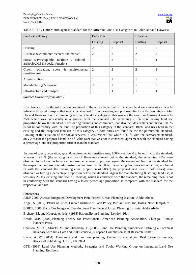
Table 5: Fit / Unfit Matrix against Standard for the Different Land Use Categories in Bahir Dar and Hawassa
Land use category Bahir Dar Hawassa
Existing Proposal Existing Proposal
Housing 2 2 1 2
Business & commerce /centers and market 2 2 2 2
Social services(public facilities , cultural , archeological & special functions
1 2 1 1
Green, recreation, sport & environmental sensitive area
2 2 2 2
Administration 1 2 1 2
Manufacturing & storage 2 2 1 2
Infrastructure and transport 1 1 1 1
Source: Extracted from table 1
It is observed from the information contained in the above table that of the seven land use categories it is only infrastructure and transport that meets the standard for both existing and proposed limits in the two cities - Bahir Dar and Hawassa. For the remaining six major land use categories this was not the case. For housing it was only 25% which was consistently in alignment with the standard. The remaining 75 % were having land use proportion below the standard. Considering business and commerce, that also includes centers and market 100 % is not in conformity with the land use proportion of this category in the standard. 100% land uses both in the existing and the proposed land use of this category in both cities are found below the permissible standard. Looking at the situation of the social services, it was evident that while 75% fit with the earmarked standard, only 25%(for the proposed land use of Bahir Dar) that was not in consistent agreement with the standard having a percentage land use proportion further than the standard.
In case of green, recreation, sport & environmental sensitive area, 100% was found to be unfit with the standard, whereas 25 % (the existing land use of Hawassa) showed below the standard, the remaining 75% were observed to be found as having a land use percentage proportion beyond the earmarked limit in the standard for the respective land use. For administration land use , while 50% ( the existing land uses in both cities) are found fit with the standard, the remaining equal proportion of 50% ( the proposed land uses in both cities) were observed as having a percentage proportion below the standard. Again for manufacturing & storage land use, it was only 25 % ( existing land use in Hawassa), which is consistent with the standard, the remaining 75% is not in conformity with the standard having a lower percentage proportion as compared with the standard for the respective land use.
References AIDP 2006. Awassa Integrated Development Plan, Federal Urban Planning Institute, Addis Ababa
Angel, S. (2012). Planet of Cities; Lincoln Institute of Land Policy; Purtian Press, Inc, Hollis, New Hampshire.
BDIDP, 2006. Bahir Dar Integrated Development Plan, Federal Urban Planning Institute, Addis Ababa
Breheny, M. and Hooper, A. (eds) (1985) Rationality in Planning, London: Pion
Brook, M.P. (2002).Planning Theory for Practitioners. American Planning Association, Chicago, Illinois; Planners Press.
Christou ,M. D. , Struckl ,M. and Biermann ,T. (2006), Land Use Planning Guidelines: Defining a Technical Data base with Risk Data and Risk Scenario, European Commission Joint Research Center.
Evans, A. W. (2004): Economics and Land use planning. Center for spatial and Real Estate Economics, Blackwell publishing Oxford, UK 2004.
GTZ (1999) Land Use Planning Methods, Strategies and Tools: Working Group on Integrated Land Use Planning, Eschborn.

Developing Country Studies www.iiste.org
ISSN 2224-607X (Paper) ISSN 2225-0565 (Online)
Vol.4, No.5, 2014
79
Harrison, P. (2006). On the Edge of reason: planning and the future of Southern African cities. Johannesburg: University of the Witwatersrand.
Healey, P. (2007). Urban complexity and Spatial strategies: Towards a rational planning for our times. London: Routledge.
Healy, P., Khakee, A., Mottee, A. & Needham, B. (1997). Making strategic spatial plans: Innovation in Europe. London: UCL Press.
Kivell .P. 2003. Land and the City: Patterns and processes of urban change. Routledge, London and New York
Ministry of Urban Development and Construction, 2012. Revised Standards for Structure Plan Preparation and Implementation, Addis Ababa.
Thomas, H. (ed.) (1994) Values and Planning, Aldershot: Avebury
Todes, A. 2011.Reinventing Planning: Critical Reflections: Urban Forum. Springer.
Ward. S.V. (2004). Planning and Urban Change, Second Edition, SAGE Publications Ltd London