Embed Size (px)
Citation preview

A Conservation Vision for Maine
Using Ecological Systems
Justin Schlawin and Andy Cutko
Maine Natural Areas Program
Maine Department of Agriculture, Conservation and Forestry
February 2014
Northern hardwood forest
Hemlock forest Shrub swamp
Cedar swamp

1
A Conservation Vision for Maine Using Ecological Systems
Contents
Summary ....................................................................................................................................................... 3
Introduction: ................................................................................................................................................. 4
Maine’s Conservation Lands: ........................................................................................................................ 4
Ecological Sections: ....................................................................................................................................... 5
Ecological Systems GIS Layer: ....................................................................................................................... 7
Consolidating Comparable Ecological Systems: ........................................................................................ 7
Requirements for Representation ................................................................................................................ 8
Isolating ‘quality’ patches for each ecological system type .................................................................... 12
Aggregation ............................................................................................................................................. 14
Results ......................................................................................................................................................... 15
Discussion ................................................................................................................................................... 21
Aroostook Hills and Lowland .................................................................................................................. 21
Laurentian Acadian Northern Hardwood Forest ................................................................................. 21
Alkaline Conifer‐Hardwood Swamp .................................................................................................... 21
Other Ecological Systems .................................................................................................................... 22
Boundary Plateau and St. John Uplands ................................................................................................. 22
Alkaline Conifer‐Hardwood Swamp .................................................................................................... 22
Laurentian‐Acadian Northern Hardwood Forest ................................................................................ 22
Other Ecological Systems .................................................................................................................... 23
Casco Bay – Penobscot Bay – Central Interior ........................................................................................ 23
Appalachian‐Acadian Pine‐Hemlock‐Hardwood Forest ...................................................................... 23
Laurentian Acadian Floodplain Forest ................................................................................................ 24
Other Ecological Systems .................................................................................................................... 24
Central‐ Western‐ White Mountains ...................................................................................................... 24

2
Southern Maine Ecological Systems .................................................................................................... 25
Other Ecological Systems .................................................................................................................... 25
Eastern Interior‐ East Coast .................................................................................................................... 25
Appalachian‐ Acadian Pine‐Hemlock‐Hardwood Forest ..................................................................... 26
Laurentian Acadian Northern Hardwood Forest ................................................................................. 26
Eastern Lowlands‐ Central Foothills ........................................................................................................ 26
Acadian Low Elevation Spruce‐Fir‐Hardwood Forest and Acadian Sub‐Boreal Spruce Flat ................ 26
Laurentian Acadian Northern Hardwood Forest ................................................................................. 27
Other Ecological Systems .................................................................................................................... 27
Seacoast Plain‐ Ossipee........................................................................................................................... 27
Appalachian‐Acadian Pine‐Hemlock‐Hardwood Forest ...................................................................... 28
North Atlantic Coastal Plain Hardwood Forest ................................................................................... 28
Northeastern Coastal and Interior Pine‐Oak Forest ............................................................................ 29
Other Ecological Systems .................................................................................................................... 29
Conclusions ................................................................................................................................................. 29
Bibliography ................................................................................................................................................ 31
Appendix 1. The Nature Conservancy’s ecoregions occurring in the state of Maine. ............................... 32
Appendix 2. Description of Ecological Systems layer. ................................................................................ 33
Appendix 3. Details of Ecological System Representation per Ecological Section ..................................... 51

3
Summary Maine has added nearly one million acres of conservation land in the last decade, and close to
20% of Maine’s land is now in some form of permanent conservation. From a biodiversity standpoint, a
region’s portfolio of conserved land should ideally represent the full variety of habitat types present in
that region. We used a regional GIS habitat layer, known as Ecological Systems, to determine how well
Maine’s conserved lands include the variety of habitats that occur in the state. We assessed all
conserved lands as well as the subset of conserved lands that are ‘reserved’ from forest management,
and we conducted the analysis statewide as well as within each of seven geographic regions. This effort
updates a previous assessment by the Maine Natural Areas Program nearly a decade ago (Cutko and
Frisina 2005).
Key findings of the assessment include:
Maine’s amount of conserved lands varies significantly by region, from 38% in northwest Maine
to 5% in central Maine. Generally, southern and central Maine have the least amount of
conserved lands, and these lands are in comparatively small parcels.
Less than 4% of Maine is in ‘reserve’ status (i.e., off limits to forest management). Proportions
of reserved lands also vary considerably, from 9% in Downeast Maine to less than 2% in the
southern Maine. Nationally, 16% of the United States is in ‘reserve’ status.
Wetlands are comparatively well represented within conserved lands throughout the state. In
four of Maine’s seven biophysical sections, wetlands are more than twice as abundant on
reserve lands as on the landscape as a whole.
Mountaintops (lands over 2700’ in elevation) are twice as abundant within conserved lands and
almost eight times as abundant within ‘reserved’ lands.
Each of 29 ecological system groups occurs at least once within conserved lands in Maine.
However, representation is poorer at the scale of seven biophysical sections. None of Maine’s
biophysical sections had adequate representation of ‘reserved’ examples of all the ecological
systems that occur in that section. Many upland forest types are under‐represented on
conserved lands in various parts of the state, and no common forest types are adequately
represented in ‘reserved’ lands in southern Maine.
Our intent with this analysis is not to propose a single habitat‐based solution for land conservation.
Rather, we hope this information will complement existing natural resource data and add to the growing
set of GIS‐based tools that may help conservation groups, state agencies, and others increase their
effectiveness at safeguarding biodiversity from a statewide perspective.
4
Introduction: Many factors are considered in evaluating where to purchase conservation land, including
scenic and recreational features, cost of land, availability of funding and potential partners, adjacency to
other conserved lands, habitat values, and others. From a biodiversity standpoint, a region’s portfolio
of conserved land should ideally represent the full variety of habitat types present within that region.
Ecological representation may be approached in a variety of ways. A Conservation Vision for Maine
Using Ecological Land Units (Cutko and Frisina 2005) examined the representation of Ecological Land
Units (ELUs) on conservation land in Maine. ELUs are enduring physical features of landform, surficial
and bedrock geology, and elevation. To conduct the 2005 analysis, Cutko and Frisina merged ELUs into
ecologically relevant groups and overlaid the most up‐to‐date conserved lands GIS layer. Since 2005
nearly one million acres of additional land have been conserved or digitized in a GIS environment in
Maine and new, more accurate GIS land cover layers have been made available. Consequently, we
sought to update and improve the 2005 analysis with the most recent information and tools.
Using a GIS landcover layer created by The Nature Conservancy in 2011, we have filtered for
‘quality’ occurrences of ecological systems statewide using a patch‐mosaic model. Using this model, we
have examined the representation of these occurrences found in ecological reserve (Gap 1 & 2) lands as
well as all conserved lands.
Maine’sConservationLands: Over one million acres of Maine
land have been conserved since 2000,
bringing the total conserved land in the
state to almost four million acres. Nearly
20% of Maine is now held in some form of
conservation, with 757,449.8 acres or
3.85% of the state off limits to timber
harvesting (i.e., US Fish and Wildlife
Service Gap 1 or Gap 2 status; see sidebar
at right).
The conserved lands layer used in
this study was developed collaboratively
by the Department of Agriculture,
Conservation and Forestry (ACF), the
Department of Inland Fisheries and
Wildlife (IFW) and The Nature
Conservancy (TNC). Prior to analysis, the
Maine Natural Areas Program
collaborated with land trusts around the
state to include their most recent
Definitions for Gap Status are as follows (from the USGS National
Gap Analysis Program):
GAP Status 1: Permanent protection from conversion of natural
land cover and a mandated management plan to maintain a
natural state within which disturbance events or are allowed to
proceed without interference or are mimicked through
management.
GAP Status 2: Permanent protection from conversion of natural
land cover and a mandated management plan to maintain a
primarily natural state, but which may receive uses or
management practices that degrade the quality of existing
natural communities, including suppression of natural
disturbance.
GAP Status 3: Permanent protection from conversion of natural
land cover for the majority of area. Subject to extractive uses of
either broad, low‐intensity type (e.g. logging) or localized intense
type (e.g.mining).
GAP Status 4: No known public/private institutional
mandates/legally recognized easements.

5
conserved lands data in our GIS layer. We obtained new data from over 70 organizations around the
state, many of which did not have parcel data digitized for the 2005 study. Collaborating with The
Nature Conservancy of Maine, Gap Status was classified for each parcel, and additional conserved lands
data was obtained.
In this study ‘Type 1’ Conservation Lands include all conserved lands, GAP Status 1, 2 and 3.
‘Type 2’ Conservation Lands are only conservation lands with GAP status 1 & 2, sometimes termed
‘forever wild’ or ‘reserve’ lands. These lands include places such as Acadia National Park, the National
Park Service’s Appalachian Trail, federal Wilderness Areas in the White Mountain National Forest and
Moosehorn Wildlife Refuge, State Ecological Reserves, land trust ownerships, and much of Baxter State
Park. Overlay analysis was performed independently for Type 1 and Type 2 Conservation lands.
EcologicalSections: Analyzing the representation of ecological systems solely at a statewide scale undervalues the
state’s regional variation. For example, spruce‐fir forest is very common in the northern part of the
state, while in southern Maine it is uncommon. To examine the representation of ecological systems
within conserved lands more finely, we examined regions of the state independently.
There are many ways of segmenting Maine, including political divisions such as township or
county lines, as well as ecological divisions that split the state into unique units defined by climate and
geography or by watershed. For this study, we use the biophysical sections from McMahon (1990) to
isolate regions of the state with similar landforms, climate, and vegetation. These sections correspond
roughly to a hierarchical system of ecoregions used by the US Forest Service (Bailey 1995). Provinces are
most general, sections are intermediate and subsections are the finest level of division (Figure 1).
We performed overlay analysis at the biophysical ‘section’ level, dividing Maine into seven
geographic units. This scale is consistent with that used for assessing the ecological representation of
Maine’s Ecological Reserves by the Ecological Reserves Scientific Advisory Committee, and it is also
compatible with The Nature Conservancy’s ecoregions, which form the outline for each group of
mapped ecological systems (Appendix 1) used in analysis.

6
Figure 1. Hierarchy of USFS Bailey Ecoregions in Maine.

7
EcologicalSystemsGISLayer: In the 2005 study, analyses were performed using a GIS layer of Ecological Land Units (ELUs).
This layer classified Maine’s landscape into units categorized by landform, geology and elevation.
Similar combinations of ELUs were grouped for analysis purposes. However, no land cover datasets were
incorporated into the 2005 analysis, and systematic ground truthing was not performed. As a result, the
2005 analysis describes landform types well but does not describe the vegetation represented by
ecological systems.
The Ecological Systems GIS layer, published in 2011, classifies terrestrial ecological systems
across the northeast by combining landform, geology, elevation, land cover data, USFS Forest Inventory
and Analysis (FIA) plot data, vegetation mapping data, and Natural Heritage community element
occurrences. The layer is a 30‐meter resolution raster dataset that covers Maine to Virginia. Ecological
systems were mapped independently in the three Nature Conservancy ecoregions (Appendix 1) and
merged. This layer classifies Maine into 72 land cover classes. For more information about the origin of
this layer, see Ferree (2011).
Generally speaking, ecological systems in this layer are coarsely defined, and they correlate with
natural communities described by the Maine Natural Areas Program (Gawler and Cutko 2010) on a one‐
to‐many basis. This layer has become an important tool to help Natural Areas Program staff identify
target areas for ecological inventory and model potential occurrences of uncommon or rare natural
community types. This layer is also the best available resource for representational analysis work. Full
descriptions of the ecological systems used in this study are in Appendix 2.
ConsolidatingComparableEcologicalSystems: Though the Ecological Systems GIS layer classifies Maine’s landscape into 72 unique types, many
of these types are too similar to be differentiated for purposes of this analysis. These systems were
aggregated for the following reasons:
1. Ecological systems were mapped separately in the Northern Appalachian – Boreal Forest, North
Atlantic Coast and Lower New England – Northern Piedmont TNC ecoregions (See Appendix 1),
and otherwise ecologically similar systems were given different names depending on the
ecoregion in which they occur;
2. Many wetland types were differentiated based on the type of water body to which they were
proximal (e.g., large river, smaller river). While this distinction is meaningful for some types of
wetlands in Maine, the scale of the layer is too coarse to determine adequate representation of
these differences; and
3. We are not confident in the differentiation of some of the small patch types that often co‐occur
on the ground. For example, Acidic Cliff, Acidic Talus, and Acidic Rocky Outcrop are
differentiated as three independent layers in the ecological systems layer.

8
Following a thorough examination, elements in the Ecological Systems were layer consolidated.
Ultimately, 32 combined units were used for further analysis including developed, open water and
agricultural land cover classes. (See Table 1 for original and grouped ecological systems.)
RequirementsforRepresentation We used two rules to determine adequate representation of each ecological system in
conservation lands:
1. Proportional Representation
Ecological Systems representation relative to each biophysical section was analyzed to determine if
ecological systems on conserved lands reflected their natural abundance on the landscape.
Following the methodology of Cutko and Frisina (2005), an ecological system is considered to be
adequately represented if it is at least half as abundant on conservation lands as in the biophysical
section as a whole. An ecological system is considered to be under represented if it is less than half
as abundant on conservation land as in the section. An ecological section is considered to be not
represented if the group does not occur in conserved lands but does occur in the ecological section.
Differing from Cutko and Frisina (2005), we first isolated ‘quality’ ecological systems based on the
patch type for each system (see following discussion on methods for isolating ‘quality’ patches).
Next we examined the total acreage of each ecological system within conserved lands, within each
ecological section. If the minimum patch size acreage was not met for a given patch, then it was not
considered conserved and was omitted from analysis.
2. Plurality
To account for adequate representation of diversity within each ecological system type, we
examined whether at least two unique patches over 1 kilometer apart were conserved in each
biophysical section. To isolate unique patches, all occurrences of a particular ecological section
occurring within 1 kilometer of another were aggregated and assigned a unique identifier (see
following section on methodology for aggregation). An ecological system was determined to be
plural if two or more system aggregates were conserved within a biophysical section and not plural
if less than two examples were conserved within a biophysical section.
All analyses were performed for Type 1 (all conserved land) and Type 2 (GAP 1 and 2) conservation lands
within each biophysical section. Ecological systems that did not occur within a biophysical section were
not analyzed.

9
Table 1. Original and merged ecological systems, from the Ecological Systems GIS layer. Descriptions of each ecological system are in Appendix 2.
Ecological System Name Merged Ecological System Name
Acadian Low Elevation Spruce‐Fir‐Hardwood Forest Acadian Low Elevation Spruce‐Fir‐Hardwood Forest
Acadian Maritime Bog Acadian Maritime Bog
Acadian Sub‐boreal Spruce Flat Acadian Sub‐boreal Spruce Flat
Acadian‐Appalachian Alpine Tundra Acadian‐Appalachian Alpine Tundra
Acadian‐Appalachian Montane Spr‐Fir‐Hwd Forest Acadian‐Appalachian Montane Spr‐Fir‐Hwd Forest
Acadian‐North Atlantic Rocky Coast Acadian‐North Atlantic Rocky Coast
Laurentian‐Acadian Acidic Cliff and Talus
Acidic Cliff, Talus and Rocky Outcrop N. Appalachian‐Acadian Rocky Heath Outcrop
North‐Central Appalachian Acidic Cliff and Talus
NLCD agricultural classes 81‐82 Agricultural
NLCD 52/71: shrublands/grasslands
Laurentian‐Acadian Alkaline Fen
Alkaline Conifer‐Hardwood Swamp
Laurentian‐Acadian Alkaline Conifer‐Hardwood Swamp: Isolated
Laurentian‐Acadian Alkaline Conifer‐Hardwood Swamp: Lake/pond: any size
Laurentian‐Acadian Alkaline Conifer‐Hardwood Swamp: Smaller river riparian
Laurentian‐Acadian Alkaline Conifer‐Hardwood Swamp: Larger river floodplain
North‐Central Interior and Appalachian Rich Swamp: Isolated
North‐Central Interior and Appalachian Rich Swamp: Lake/pond: any size
North‐Central Interior and Appalachian Rich Swamp: Smaller river riparian
Laurentian‐Acadian Pine‐Hemlock‐Hardwood Forest: typic
Appalachian‐Acadian Pine‐Hemlock‐Hardwood Forest
Laurentian‐Acadian Pine‐Hemlock‐Hardwood Forest: moist‐cool
Appalachian (Hemlock)‐Northern Hardwood Forest: typic
Appalachian (Hemlock)‐Northern Hardwood Forest: drier
Appalachian (Hemlock)‐Northern Hardwood Forest: moist‐cool
Laurentian‐Acadian Calcareous Cliff and Talus
Calcareous Cliff, Talus and Rocky Outcrop Laurentian‐Acadian Calcareous Rocky Outcrop
North‐Central Appalachian Circumneutral Cliff and Talus
Central Appalachian Alkaline Glade and Woodland Central Appalachian Alkaline Glade and Woodland

10
Central Appalachian Dry Oak‐Pine Forest Central Appalachian Dry Oak‐Pine Forest
Central Appalachian Pine‐Oak Rocky Woodland
North‐Central Appalachian Acidic Swamp: Larger river floodplain Central Appalachian Floodplain Forest
North‐Central Interior and Appalachian Rich Swamp: Larger river floodplain
NLCD developed classes 21‐24 & 31 Developed
Boreal‐Laurentian Bog
Laurentian‐ N. Appalachian‐Boreal Peatland
Boreal‐Laurentian‐Acadian Acidic Basin Fen
North‐Central Interior and Appalachian Acidic Peatland: Isolated/headwater streams
North‐Central Interior and Appalachian Acidic Peatland: Undifferentiated
North‐Central Interior and Appalachian Acidic Peatland: Lake/pond: any size
North‐Central Interior and Appalachian Acidic Peatland: Smaller river riparian
Laurentian‐Acadian Floodplain Forest Laurentian‐Acadian Floodplain Forest
Eastern Boreal Floodplain
Laurentian‐Acadian Freshwater Marsh: Isolated
Laurentian‐Acadian Freshwater Marsh Laurentian‐Acadian Freshwater Marsh: Lake/pond: any size
Laurentian‐Acadian Freshwater Marsh: Smaller river riparian
Laurentian‐Acadian Freshwater Marsh: Larger river floodplain
Laurentian‐Acadian Northern Hardwood Forest: typic Laurentian‐Acadian Northern Hardwood Forest
Laurentian‐Acadian Northern Hardwoods Forest: moist‐cool
Laurentian‐Acadian Northern Hardwood Forest, high conifer Laurentian‐Acadian Northern Hardwood Forest, high conifer
Laurentian‐Acadian Red Oak‐Northern Hardwood Forest Laurentian‐Acadian Red Oak‐Northern Hardwood Forest
Laurentian‐Acadian Wet Meadow‐Shrub Swamp: Isolated
Laurentian‐Acadian Wet Meadow‐Shrub Swamp Laurentian‐Acadian Wet Meadow‐Shrub Swamp: Lake/pond: any size
Laurentian‐Acadian Wet Meadow‐Shrub Swamp: Smaller river riparian
Laurentian‐Acadian Wet Meadow‐Shrub Swamp: Larger river floodplain
North Atlantic Coastal Plain Basin Peat Swamp: Isolated/headwater streams North Atlantic Coastal Plain Basin Peat Swamp
North Atlantic Coastal Plain Basin Peat Swamp: Smaller river riparian
North Atlantic Coastal Plain Hardwood Forest North Atlantic Coastal Plain Hardwood Forest
North Atlantic Coastal Plain Maritime Forest North Atlantic Coastal Plain Maritime Forest

11
North‐Central Appalachian Pine Barrens North‐Central Appalachian Pine Barrens
North‐Central Interior Wet Flatwoods North‐Central Interior Wet Flatwoods
Northeastern Coastal and Interior Pine‐Oak Forest Northeastern Coastal and Interior Pine‐Oak Forest
Northern Appalachian‐Acadian Conifer‐Hardwood Acidic Swamp: Isolated
Northern Appalachian‐Acadian Conifer‐Hardwood Acidic Swamp
Northern Appalachian‐Acadian Conifer‐Hardwood Acidic Swamp: Lake/pond: any size Northern Appalachian‐Acadian Conifer‐Hardwood Acidic Swamp: Smaller river riparian Northern Appalachian‐Acadian Conifer‐Hardwood Acidic Swamp: Larger river floodplain
North‐Central Appalachian Acidic Swamp: Isolated
North‐Central Appalachian Acidic Swamp: Lake/pond: any size
North‐Central Appalachian Acidic Swamp: Smaller river riparian
Northern Atlantic Coastal Plain Dune and Swale/Sandy Beach Northern Atlantic Coastal Plain Dune and Swale/Sandy Beach
NLCD‐NHD open water Open Water
North Atlantic Coastal Plain Tidal Salt Marsh: salt/brackish/oligohaline
Tidal Marsh Acadian Coastal Salt Marsh, Acadian Estuary Marsh
Acadian Estuary Marsh

12
Isolating‘quality’patchesforeachecologicalsystemtype In the 2005 study, only proportional representation of ELU groups in conserved lands was
analyzed. In other words, representation of ELU groups occurring on conserved land was analyzed
relative to total area of ELU groups occurring within a geographic area. However, the size of ELU patches
and adequate protection of ELU groups was not analyzed. In this analysis, we attempt to take a step
further than the previous study and isolate ‘quality’ (minimum size) patches of each ecological system
type for representational analysis.
Habitat or ecological system ‘Patches’ are relatively unique, dynamic homogenous units,
occurring naturally or as a result of human activity at various sizes and in various shapes (Forman 1995).
The scale of these patches differs based on the factors that influence their composition and structure,
including climate, topography, geology and disturbance. Patches are typically categorized into a series
of unique units which are then classified as small/large patch and matrix types.
The size at which these patches occur is relevant to their conservation value. For example, an
isolated three‐acre patch of Acadian Low Elevation Spruce‐Fir Hardwood Forest (a common, matrix –
forming ecological system) cannot be expected to contain the full range of ecological diversity inherent
in this natural community type. The scale of this small example of spruce‐fir forest is not representative
for its type, and would have a much lower conservation value than a large, representative example.
Conversely, a three acre patch of Calcareous Cliff, Talus and Rocky Outcrop (a small patch type) may
support the full range of ecological diversity expected for this system in Maine.
We chose to filter the ecological systems layer to remove examples below a minimum size
threshold prior to analysis, thereby removing ‘low quality’ examples of each type. We classified all
ecological systems as either small, medium, large patch or matrix types, based on the ecology of each
type and the average patch size within the ecological systems layer (See Table 2). The minimum size
threshold was set at 3 acres for small patch; 10 acres for medium patch; 50 acres for large patch; and
250 acres for matrix systems. All features that were below the minimum threshold for their type were
removed from the dataset. We define patches as being ‘quality examples’ for their type if they are
above this minimum size threshold.
For ‘quality’ ecological system patches to be captured in conserved lands in our analysis, the
above minimum patch size thresholds must be captured within the conserved lands boundary. If
partially conserved ecological system patches were below these size thresholds, they were not
considered captured within conservation lands.

13
Table 2. Grouped ecological systems, with patch size and minimum acreage classified for each type.
Merged Ecological Systems Patch size Minimum Acreage
Acadian Low Elevation Spruce‐Fir‐Hardwood Forest matrix 250
Acadian Maritime Bog large 50
Acadian Sub‐boreal Spruce Flat large 50
Acadian‐Appalachian Alpine Tundra small 3
Acadian‐Appalachian Montane Spruce‐Fir‐Hardwood Forest matrix 250
Acadian‐North Atlantic Rocky Coast small 3
Acidic Cliff, Talus and Rocky Outcrop small 3
Agricultural N/A N/A
Alkaline Conifer‐Hardwood Swamp small 3
Appalachian‐Acadian Pine‐Hemlock‐Hardwood Forest matrix 250
Calcareous Cliff, Talus and Rocky Outcrop small 3
Central Appalachian Alkaline Glade and Woodland small 3
Central Appalachian Dry Oak‐Pine Forest medium 10
Central Appalachian Floodplain Forest medium 10
Developed N/A N/A
Laurentian‐ N. Appalachian‐Boreal Peatland large 50
Laurentian‐Acadian Floodplain Forest medium 10
Laurentian‐Acadian Freshwater Marsh medium 10
Laurentian‐Acadian Northern Hardwood Forest matrix 250
Laurentian‐Acadian Northern Hardwood Forest, high conifer matrix 250
Laurentian‐Acadian Red Oak‐Northern Hardwood Forest matrix 250
Laurentian‐Acadian Wet Meadow‐Shrub Swamp medium 10
North Atlantic Coastal Plain Basin Peat Swamp large 50
North Atlantic Coastal Plain Hardwood Forest matrix 250
North Atlantic Coastal Plain Maritime Forest large 50
North‐Central Appalachian Pine Barrens large 50
North‐Central Interior Wet Flatwoods medium 10
Northeastern Coastal and Interior Pine‐Oak Forest matrix 250
Northern Appalachian‐Acadian Conifer‐Hardwood Acidic Swamp large 50
Northern Atlantic Coastal Plain Dune and Swale/Sandy Beach small 3
Open Water N/A N/A
Tidal Marsh medium 10

14
Aggregation To test the plurality of ecological systems conserved in each biophysical section, each unique
ecological system occurrence was assigned an identifier. ‘Unique’ systems were defined as groups of
features over one kilometer from another feature of the same type. This aggregate dataset provided
the base for each feature’s unique ‘aggregate id’. The ‘aggregate id’ was then spatially joined back to
the original feature without affecting the geometry of the original feature (e.g. Figure 2). Within each
ecological section, at least two examples of an ecological system had to occur within conserved lands for
that system type to be represented.
Figure 2. Floodplain Forest occurrences from the Ecological Systems GIS layer, overlaid by 1 kilometer Floodplain Forest aggregation zones. Each feature is assigned the ID of the aggregation zone in which it falls. For an ecological system to be adequately represented, sufficient acreage of features from at least two unique aggregates zones must occur in Type 1 and Type 2 conserved lands.

15
Results
Conserved Land
The distribution of Type 1 and Type 2 conserved lands in the biophysical sections of Maine is
shown in Figure 3 and Table 3.
Table 3. Distribution of conserved land in Maine’s seven biophysical sections. Values are represented in acres and as a percentage of total land area. Open water was excluded from analysis.
Biophysical section Type 1 Cons. Land
Acres (% of section)Type 2 Cons. Land
Acres (% of section) Total Land Area
Acres
Aroostook Hills and Lowlands 210,728 (8.8%) 20,067 (0.8%) 2,382,758
Boundary Plateau and St. John Uplands 1,318,743 (37.5%) 95,507 (2.7%) 3,512,934
Casco Bay ‐ Penobscot Bay ‐ Central Interior 184,386 (5.1%) 80,458 (2.2%) 3,646,120
Central ‐ Western ‐ White Mountains 1,242,366 (29.4%) 365,540 (8.6%) 4,232,247
Eastern Interior ‐ East Coast 253,913 (17.3%) 129,798 (8.9%) 1,464,628
Eastern Lowlands ‐ Central Foothills 509,104 (16.7%) 36,265 (1.2%) 3,042,033
Seacoast Plain – Ossipee 105,601 (7.6%) 29,814 (2.2%) 1,384,041
Total 3,824,842 (19.5%) 757,450 (3.9%) 19,664,758
Overlay analysis indicates that conserved lands, and especially Type 2 conserved lands, contain
considerably higher proportions of wetlands than occur on the landscape as a whole (Table 4).
Wetlands are generally well represented in conserved lands in all biophysical sections. In four of
Maine’s seven biophysical regions, wetlands are more than twice as abundant in Type 2 conserved lands
as on the landscape as a whole.
38%
5%
8%
17%
17%
29%
9% 3% 1%
9%
2%
2%
1%
9%
Figure 3. Proportions of Type 1, or all conserved land in Maine, by biophysical section (left) and proportions of Type 2, or ‘reserved,’ land (right).
16
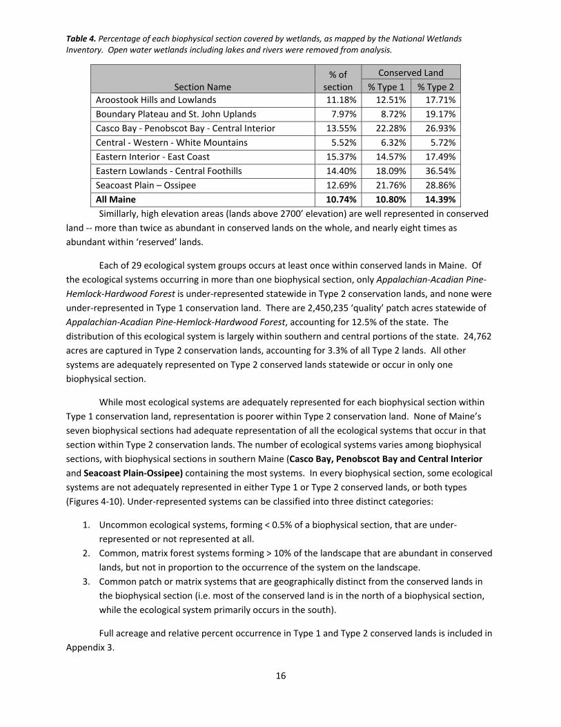
Table 4. Percentage of each biophysical section covered by wetlands, as mapped by the National Wetlands Inventory. Open water wetlands including lakes and rivers were removed from analysis.
Section Name % of
section
Conserved Land
% Type 1 % Type 2
Aroostook Hills and Lowlands 11.18% 12.51% 17.71%
Boundary Plateau and St. John Uplands 7.97% 8.72% 19.17%
Casco Bay ‐ Penobscot Bay ‐ Central Interior 13.55% 22.28% 26.93%
Central ‐ Western ‐ White Mountains 5.52% 6.32% 5.72%
Eastern Interior ‐ East Coast 15.37% 14.57% 17.49%
Eastern Lowlands ‐ Central Foothills 14.40% 18.09% 36.54%
Seacoast Plain – Ossipee 12.69% 21.76% 28.86%
All Maine 10.74% 10.80% 14.39%
Simillarly, high elevation areas (lands above 2700’ elevation) are well represented in conserved
land ‐‐ more than twice as abundant in conserved lands on the whole, and nearly eight times as
abundant within ‘reserved’ lands.
Each of 29 ecological system groups occurs at least once within conserved lands in Maine. Of
the ecological systems occurring in more than one biophysical section, only Appalachian‐Acadian Pine‐
Hemlock‐Hardwood Forest is under‐represented statewide in Type 2 conservation lands, and none were
under‐represented in Type 1 conservation land. There are 2,450,235 ‘quality’ patch acres statewide of
Appalachian‐Acadian Pine‐Hemlock‐Hardwood Forest, accounting for 12.5% of the state. The
distribution of this ecological system is largely within southern and central portions of the state. 24,762
acres are captured in Type 2 conservation lands, accounting for 3.3% of all Type 2 lands. All other
systems are adequately represented on Type 2 conserved lands statewide or occur in only one
biophysical section.
While most ecological systems are adequately represented for each biophysical section within
Type 1 conservation land, representation is poorer within Type 2 conservation land. None of Maine’s
seven biophysical sections had adequate representation of all the ecological systems that occur in that
section within Type 2 conservation lands. The number of ecological systems varies among biophysical
sections, with biophysical sections in southern Maine (Casco Bay, Penobscot Bay and Central Interior
and Seacoast Plain‐Ossipee) containing the most systems. In every biophysical section, some ecological
systems are not adequately represented in either Type 1 or Type 2 conserved lands, or both types
(Figures 4‐10). Under‐represented systems can be classified into three distinct categories:
1. Uncommon ecological systems, forming < 0.5% of a biophysical section, that are under‐
represented or not represented at all.
2. Common, matrix forest systems forming > 10% of the landscape that are abundant in conserved
lands, but not in proportion to the occurrence of the system on the landscape.
3. Common patch or matrix systems that are geographically distinct from the conserved lands in
the biophysical section (i.e. most of the conserved land is in the north of a biophysical section,
while the ecological system primarily occurs in the south).
Full acreage and relative percent occurrence in Type 1 and Type 2 conserved lands is included in
Appendix 3.
17
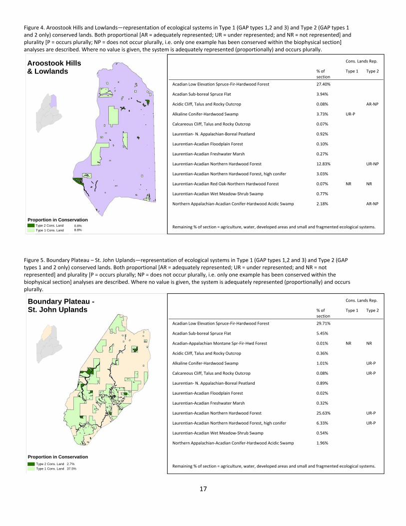
Figure 4. Aroostook Hills and Lowlands—representation of ecological systems in Type 1 (GAP types 1,2 and 3) and Type 2 (GAP types 1 and 2 only) conserved lands. Both proportional [AR = adequately represented; UR = under represented; and NR = not represented] and plurality [P = occurs plurally; NP = does not occur plurally, i.e. only one example has been conserved within the biophysical section] analyses are described. Where no value is given, the system is adequately represented (proportionally) and occurs plurally.
Figure 5. Boundary Plateau – St. John Uplands—representation of ecological systems in Type 1 (GAP types 1,2 and 3) and Type 2 (GAP types 1 and 2 only) conserved lands. Both proportional [AR = adequately represented; UR = under represented; and NR = not represented] and plurality [P = occurs plurally; NP = does not occur plurally, i.e. only one example has been conserved within the biophysical section] analyses are described. Where no value is given, the system is adequately represented (proportionally) and occurs plurally.
Proportion in Conservation
Aroostook Hills & Lowlands
Type 2 Cons. Land
Type 1 Cons. Land 0.8%8.8%
Boundary Plateau -St. John Uplands
Proportion in Conservation
Cons. Lands Rep.
% of section
Type 1 Type 2
Acadian Low Elevation Spruce‐Fir‐Hardwood Forest 27.40%
Acadian Sub‐boreal Spruce Flat 3.94%
Acidic Cliff, Talus and Rocky Outcrop 0.08% AR‐NP
Alkaline Conifer‐Hardwood Swamp 3.73% UR‐P
Calcareous Cliff, Talus and Rocky Outcrop 0.07%
Laurentian‐ N. Appalachian‐Boreal Peatland 0.92%
Laurentian‐Acadian Floodplain Forest 0.10%
Laurentian‐Acadian Freshwater Marsh 0.27%
Laurentian‐Acadian Northern Hardwood Forest 12.83% UR‐NP
Laurentian‐Acadian Northern Hardwood Forest, high conifer 3.03%
Laurentian‐Acadian Red Oak‐Northern Hardwood Forest 0.07% NR NR
Laurentian‐Acadian Wet Meadow‐Shrub Swamp 0.77%
Northern Appalachian‐Acadian Conifer‐Hardwood Acidic Swamp 2.18% AR‐NP
Remaining % of section = agriculture, water, developed areas and small and fragmented ecological systems.
Cons. Lands Rep.
% of section
Type 1 Type 2
Acadian Low Elevation Spruce‐Fir‐Hardwood Forest 29.71%
Acadian Sub‐boreal Spruce Flat 5.45%
Acadian‐Appalachian Montane Spr‐Fir‐Hwd Forest 0.01% NR NR
Acidic Cliff, Talus and Rocky Outcrop 0.36%
Alkaline Conifer‐Hardwood Swamp 1.01% UR‐P
Calcareous Cliff, Talus and Rocky Outcrop 0.08% UR‐P
Laurentian‐ N. Appalachian‐Boreal Peatland 0.89%
Laurentian‐Acadian Floodplain Forest 0.02%
Laurentian‐Acadian Freshwater Marsh 0.32%
Laurentian‐Acadian Northern Hardwood Forest 25.63% UR‐P
Laurentian‐Acadian Northern Hardwood Forest, high conifer 6.33% UR‐P
Laurentian‐Acadian Wet Meadow‐Shrub Swamp 0.54%
Northern Appalachian‐Acadian Conifer‐Hardwood Acidic Swamp 1.96%
Remaining % of section = agriculture, water, developed areas and small and fragmented ecological systems. Type 2 Cons. Land 2.7%
Type 1 Cons. Land 37.5%

18
Figure 6. Casco Bay, Penobscot Bay and Central Interior—representation of ecological systems in Type 1 (GAP types 1,2 and 3) and Type 2 (GAP types 1 and 2 only) conserved lands. Both proportional [AR = adequately represented; UR = under represented; and NR = not represented] and plurality [P = occurs plurally; NP = does not occur plurally, i.e. only one example has been conserved within the biophysical section] analyses are described. Where no value is given, the system is adequately represented (proportionally) and occurs plurally.
Figure 7. Central and Western Mountains—representation of ecological systems in Type 1 (GAP types 1,2 and 3) and Type 2 (GAP types 1 and 2 only) conserved lands. Both proportional [AR = adequately represented; UR = under represented; and NR = not represented] and plurality [P = occurs plurally; NP = does not occur plurally, i.e. only one example has been conserved within the biophysical section] analyses are described. Where no value is given, the system is adequately represented (proportionally) and occurs plurally.
Casco Bay Penobscot Bay Central Interior Proportion in Conservation
Central & Western Mountains
Proportion in Conservation
Cons. Lands Rep.
% of section
Type 1 Type 2
Acadian Low Elevation Spruce‐Fir‐Hardwood Forest 16.07%
Acadian Sub‐boreal Spruce Flat 1.85%
Acadian‐Appalachian Alpine Tundra 0.09%
Acadian‐Appalachian Montane Spr‐Fir‐Hwd Forest 9.31%
Acidic Cliff, Talus and Rocky Outcrop 1.37%
Alkaline Conifer‐Hardwood Swamp 0.79% UR‐P
Appalachian‐Acadian Pine‐Hemlock‐Hardwood Forest 4.80% UR‐P UR‐NP
Calcareous Cliff, Talus and Rocky Outcrop 0.27%
Central Appalachian Dry Oak‐Pine Forest 0.01% NR
Laurentian‐ N. Appalachian‐Boreal Peatland 0.42%
Laurentian‐Acadian Floodplain Forest 0.07%
Laurentian‐Acadian Freshwater Marsh 0.22%
Laurentian‐Acadian Northern Hardwood Forest 26.53%
Laurentian‐Acadian Northern Hardwood Forest, high conifer 4.62%
Laurentian‐Acadian Red Oak‐Northern Hardwood Forest 3.61% UR‐P UR‐P
Laurentian‐Acadian Wet Meadow‐Shrub Swamp 0.63%
Northern Appalachian‐Acadian Conifer‐Hardwood Acidic Swamp 0.76%
Remaining % of section = agriculture, water, developed areas and small and fragmented ecological systems.
Cons. Lands Rep.
% of section
Type 1 Type 2
Acadian Low Elevation Spruce‐Fir‐Hardwood Forest 4.05%
Acadian Maritime Bog 0.01% NR NR
Acadian Sub‐boreal Spruce Flat 0.56%
Acadian‐North Atlantic Rocky Coast 0.06%
Acidic Cliff, Talus and Rocky Outcrop 0.05%
Alkaline Conifer‐Hardwood Swamp 4.05%
Appalachian‐Acadian Pine‐Hemlock‐Hardwood Forest 30.80% UR‐NP
Calcareous Cliff, Talus and Rocky Outcrop 0.02%
Central Appalachian Dry Oak‐Pine Forest 0.03%
Laurentian‐ N. Appalachian‐Boreal Peatland 1.65%
Laurentian‐Acadian Floodplain Forest 0.21% UR‐P
Laurentian‐Acadian Freshwater Marsh 1.23%
Laurentian‐Acadian Northern Hardwood Forest 2.55%
Laurentian‐Acadian Northern Hardwood Forest, high conifer 0.08% NR NR
Laurentian‐Acadian Red Oak‐Northern Hardwood Forest 4.39%
Laurentian‐Acadian Wet Meadow‐Shrub Swamp 1.22%
North Atlantic Coastal Plain Maritime Forest 0.46%
Northern Appalachian‐Acadian Conifer‐Hardwood Acidic Swamp 0.59%
Northern Atlantic Coastal Plain Dune and Swale/Sandy Beach 0.03%
Tidal Marsh 0.25%
Remaining % of section = agriculture, water, developed areas and small and fragmented ecological systems. Type 2 Cons. Land 2.2%
Type 1 Cons. Land 5.1%
Type 2 Cons. Land 8.6%
Type 1 Cons. Land 29.4%
19
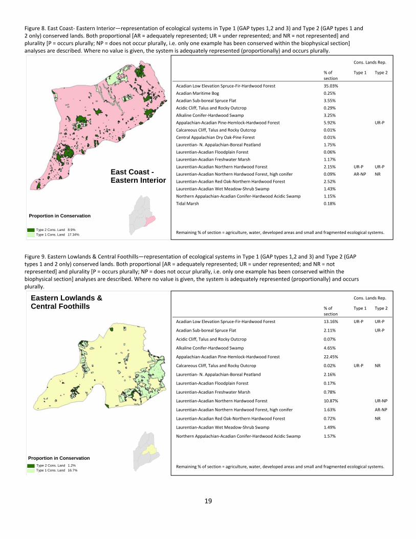
Figure 8. East Coast‐ Eastern Interior—representation of ecological systems in Type 1 (GAP types 1,2 and 3) and Type 2 (GAP types 1 and 2 only) conserved lands. Both proportional [AR = adequately represented; UR = under represented; and NR = not represented] and plurality [P = occurs plurally; NP = does not occur plurally, i.e. only one example has been conserved within the biophysical section] analyses are described. Where no value is given, the system is adequately represented (proportionally) and occurs plurally.
Figure 9. Eastern Lowlands & Central Foothills—representation of ecological systems in Type 1 (GAP types 1,2 and 3) and Type 2 (GAP types 1 and 2 only) conserved lands. Both proportional [AR = adequately represented; UR = under represented; and NR = not represented] and plurality [P = occurs plurally; NP = does not occur plurally, i.e. only one example has been conserved within the biophysical section] analyses are described. Where no value is given, the system is adequately represented (proportionally) and occurs plurally.
East Coast - Eastern Interior
Proportion in Conservation
Eastern Lowlands &Central Foothills
Proportion in Conservation
Cons. Lands Rep.
% of section
Type 1 Type 2
Acadian Low Elevation Spruce‐Fir‐Hardwood Forest 13.16% UR‐P UR‐P
Acadian Sub‐boreal Spruce Flat 2.11% UR‐P
Acidic Cliff, Talus and Rocky Outcrop 0.07%
Alkaline Conifer‐Hardwood Swamp 4.65%
Appalachian‐Acadian Pine‐Hemlock‐Hardwood Forest 22.45%
Calcareous Cliff, Talus and Rocky Outcrop 0.02% UR‐P NR
Laurentian‐ N. Appalachian‐Boreal Peatland 2.16%
Laurentian‐Acadian Floodplain Forest 0.17%
Laurentian‐Acadian Freshwater Marsh 0.78%
Laurentian‐Acadian Northern Hardwood Forest 10.87% UR‐NP
Laurentian‐Acadian Northern Hardwood Forest, high conifer 1.63% AR‐NP
Laurentian‐Acadian Red Oak‐Northern Hardwood Forest 0.72% NR
Laurentian‐Acadian Wet Meadow‐Shrub Swamp 1.49%
Northern Appalachian‐Acadian Conifer‐Hardwood Acidic Swamp 1.57%
Remaining % of section = agriculture, water, developed areas and small and fragmented ecological systems.
Cons. Lands Rep.
% of section
Type 1 Type 2
Acadian Low Elevation Spruce‐Fir‐Hardwood Forest 35.03%
Acadian Maritime Bog 0.25%
Acadian Sub‐boreal Spruce Flat 3.55%
Acidic Cliff, Talus and Rocky Outcrop 0.29%
Alkaline Conifer‐Hardwood Swamp 3.25%
Appalachian‐Acadian Pine‐Hemlock‐Hardwood Forest 5.92% UR‐P
Calcareous Cliff, Talus and Rocky Outcrop 0.01%
Central Appalachian Dry Oak‐Pine Forest 0.01%
Laurentian‐ N. Appalachian‐Boreal Peatland 1.75%
Laurentian‐Acadian Floodplain Forest 0.06%
Laurentian‐Acadian Freshwater Marsh 1.17%
Laurentian‐Acadian Northern Hardwood Forest 2.15% UR‐P UR‐P
Laurentian‐Acadian Northern Hardwood Forest, high conifer 0.09% AR‐NP NR
Laurentian‐Acadian Red Oak‐Northern Hardwood Forest 2.52%
Laurentian‐Acadian Wet Meadow‐Shrub Swamp 1.43%
Northern Appalachian‐Acadian Conifer‐Hardwood Acidic Swamp 1.15%
Tidal Marsh 0.18%
Remaining % of section = agriculture, water, developed areas and small and fragmented ecological systems. Type 2 Cons. Land 8.9%
Type 1 Cons. Land 17.34%
Type 2 Cons. Land 1.2%
Type 1 Cons. Land 16.7%

20
Figure 10. South Coastal & South West Interior—representation of ecological systems in Type 1 (GAP types 1,2 and 3) and Type 2 (GAP types 1 and 2 only) conserved lands. Both proportional [AR = adequately represented; UR = under represented; and NR = not represented] and plurality [P = occurs plurally; NP = does not occur plurally, i.e. only one example has been conserved within the biophysical section] analyses are described. Where no value is given, the system is adequately represented (proportionally) and occurs plurally.
Seacoast Plain- Ossipee
Proportion in Conservation
Cons. Lands Rep.
% of section
Type 1 Type 2
Acadian‐North Atlantic Rocky Coast 0.05%
Acidic Cliff, Talus and Rocky Outcrop 0.10%
Alkaline Conifer‐Hardwood Swamp 3.30%
Appalachian‐Acadian Pine‐Hemlock‐Hardwood Forest 25.59% UR‐NP
Calcareous Cliff, Talus and Rocky Outcrop 0.06%
Central Appalachian Alkaline Glade and Woodland 0.01% NR
Central Appalachian Dry Oak‐Pine Forest 0.17%
Central Appalachian Floodplain Forest 0.55%
Laurentian‐ N. Appalachian‐Boreal Peatland 0.17%
Laurentian‐Acadian Freshwater Marsh 0.93%
Laurentian‐Acadian Wet Meadow‐Shrub Swamp 1.18%
North Atlantic Coastal Plain Basin Peat Swamp 0.04% AR‐NP NR
North Atlantic Coastal Plain Hardwood Forest 0.95% NR
North Atlantic Coastal Plain Maritime Forest 0.13%
North‐Central Appalachian Pine Barrens 0.37% AR‐NP
North‐Central Interior Wet Flatwoods 0.13% UR‐NP UR‐NP
Northeastern Coastal and Interior Pine‐Oak Forest 13.00% UR‐NP
Northern Appalachian‐Acadian Conifer‐Hardwood Acidic Swamp 1.77%
Northern Atlantic Coastal Plain Dune and Swale/Sandy Beach 0.17%
Tidal Marsh 0.54%
Remaining % of section = agriculture, water, developed areas and small and fragmented ecological systems.
Type 2 Cons. Land 2.2%
Type 1 Cons. Land 7.6%

21
Discussion
This relative preponderance of wetlands and mountaintops within Maine’s conserved lands is
not surprising, given their high ecological and scenic importance, low development and forestry
potential, regulatory constraints, and inexpensive land values. An estimated 85% of Maine’s vertebrate
species use wetlands or riparian areas at some point during their life cycles (Boone and Krohn 1998).
Mountaintops provide habitat for a variety of rare plants and animals and may serve as important
refugia in a changing climate. As a result, the abundance of wetlands and high elevation areas in
Maine’s conservation lands has likely paid strong dividends for biodiversity.
In the following section, we examine under‐represented ecological systems in each biophysical
section to discern trends and limitations in the data, as well as identify anomalies resulting from our
rules for representation.
AroostookHillsandLowland
The Aroostook Hills and Lowland biophysical section has the least Type 2 conserved land in
Maine. Most of the conserved land is working forest fee and easement lands, with the exception of a
small section of Baxter State Park and a small handful of properties in the northeast of the section. The
distribution and low acreage of Type 2 conserved land accounts for the under‐representation of several
ecological systems.
LaurentianAcadianNorthernHardwoodForestLaurentian Acadian Northern Hardwood Forest is the second most common ecological system in
this section (Figure 4). It occupies many of the small ridges and hills that pepper the landscape, and it is
under‐represented because of the scarcity and patchiness of Type 2 conserved land. Only one example
is conserved in Type 2 conserved land (in Baxter State Park). In Type 1 conserved land, Laurentian
Acadian Northern Hardwood Forest is conserved on working forest easement land and in the Scopan
Unit (Maine BP&L). Laurentian Acadian Northern Hardwood Forest – High Conifer, a variant that may
occur on northerly aspects and has roughly 25% or more conifers in the overstory, is conserved in Baxter
State Park and in Aroostook State Park, both Type 2 conserved land.
AlkalineConifer‐HardwoodSwamp It is unusual that an ecological system would be adequately represented on Type 2 conserved
land but not on Type 1 conserved land. In the Aroostook Hills and Lowland biophysical section, Alkaline
Conifer‐Hardwood Swamp (roughly analogous to Northern White Cedar Swamp or Cedar‐Spruce
Seepage Forest and classified as a small patch type, following Gawler and Cutko 2010) is conserved in
Marble Fen and Woodland Bog (TNC), Baxter State Park, and Aroostook National Wildlife Refuge. Due to
the relatively low acreage of Type 2 conserved land in this biophysical section, these examples of
Alkaline Conifer‐Hardwood Swamp (764 total acres, Appendix 3) constitute 3.8% of Type 2 conserved
land area, while ‘quality’ examples of this system type only account for 3.7% of the total landscape.
The distribution of Type 1 conserved land accounts for the under‐representation of Alkaline
Conifer‐Hardwood Swamp. Large blocks of working forest easements occur on the western side of the

22
Aroostook Hills and Lowlands biophysical section. Because most of the Alkaline Conifer‐Hardwood
Swamp occurs on the lowlands in the eastern side of the section, it is not captured in Type 1 conserved
land.
OtherEcologicalSystems Several ecological systems are adequately represented in Type 2 conserved land in terms of
acreage, but do not occur plurally. These included Acidic Cliff, Talus and Rocky Outcrop and Northern
Appalachian‐Acadian Conifer Hardwood Acidic Swamp. The under representation of these systems is
largely a result of the relatively low amount of Type 2 conserved land in the Aroostook Hills and
Lowland. Additionally, for open upland types such as Acidic Cliff, Talus and Rocky Outcrop,
representation in Type 2 conservation lands is somewhat irrelevant—this system may be equally well
protected in Type 1 conserved lands as Type 2 conserved lands, unless the potential for mining exists.
Laurentian‐Acadian Red Oak‐ Northern Hardwood Forest is very rare in this region, and is, as a
result, not represented in conserved lands. Representation of rare or uncommon systems is better
described through analysis of Natural Areas Program element occurrence data, because the Ecological
Systems GIS layer is more likely to be inaccurate a fine scale.
BoundaryPlateauandSt.JohnUplands
There is more Type 1 conserved land in the Boundary Plateau and St. John Uplands than any of
the other biophysical sections, in terms of both total acreage and as a percentage of the biophysical
section (Table 3). Type 1 conserved land includes several large working forest easements and land
owned in fee by the state and private conservation groups. Type 2 conservation land is not nearly as
common and includes lands owned by The Nature Conservancy and ecoreserves owned and managed by
the Division of Parks and Public Lands. No systems are under‐represented in Type 1 conservation land,
but several systems are under‐represented in Type 2 conserved land.
AlkalineConifer‐HardwoodSwamp Most of the Alkaline Conifer‐Hardwood Swamp that occurs in Type 2 conserved land is in the
Division of Parks and Public Lands Chamberlain Lake Unit. Most of the examples of this system occur
along the east and southeast of the unit but do not intersect the largest piece of Type 2 conserved land:
The Nature Conservancy’s Upper St. John River Watershed Reserve. Alkaline Conifer‐Hardwood Swamp
is largely missing from the Type 2 conserved lands portfolio, but is captured numerous times in working
forest easements (Type 1).
Laurentian‐AcadianNorthernHardwoodForest Laurentian‐Acadian Northern Hardwood Forest and Laurentian‐Acadian Northern Hardwood
Forest, High Conifer are the second and third most dominant systems on the landscape. Their combined
acreage is actually higher than Acadian Low Elevation Spruce‐Fir‐Hardwood Forest. These types are
under‐represented because, though they occurred scattered throughout the smaller blocks of Type 2
conserved lands around the section, they are very scarce in TNC’s Upper St. John River Watershed

23
Reserve (~56,000 acres), the largest block of Type 2 conserved land in the Boundary Plateau and St.
John Uplands biophysical section. These systems are adequately represented in Type 1 conservation
lands.
OtherEcologicalSystems Acadian‐Appalachian Montane Spruce‐Fir‐Hardwood Forest is not represented in either
conserved land type. The only occurrence of this system in the Boundary Plateau and St. John Uplands
is on Russell Mountain in Russell Pond Township. It is not clear whether this occurrence should be
distinct from the surrounding Acadian Low Elevation Spruce‐ Fir Hardwood Forest. This can only be
assessed through field examination.
Differentiated between Type 1 and Type 2 conserved land for non‐forested upland types such as
Calcareous Cliff, Talus and Rocky Outcrop may be irrelevant. GAP 3 status is an equivalent level of
protection for these sites as GAP 1 or GAP 2, unless the potential for mining exists.
CascoBay–PenobscotBay–CentralInterior
The Casco Bay – Penobscot Bay – Central Interior has the least Type 1 conserved land
proportionally of any of the biophysical sections, but is roughly average for Type 2 conserved land.
Because this biophysical section contains the greatest number of ecological systems (tied with Seacoast
Plain – Ossipee), it is somewhat surprising that very few systems are under‐represented. This reason for
this has likely to do with the distribution of conserved lands: unlike northern and eastern sections, there
are no large (> 10,000 acres) blocks of conservation land. Rather, conserved lands are distributed more
evenly across the landscape. Because of this even distribution, ecological systems are not isolated
geographically from conserved lands. However, because parcel sizes are small for Type 2 conserved
lands, large ‘quality examples’ of matrix forest are not as well captured.
Appalachian‐AcadianPine‐Hemlock‐HardwoodForest Appalachian‐Acadian Pine‐Hemlock‐Hardwood Forest is the most common ecological system
within the section (30.8%, Appendix 3) and one of the most common in the state. Though this system is
the most common type conserved in Type 2 conserved land (11,762 acres, or 14.6%), this system is
under‐represented because it is proportionally far more common on the landscape as a whole, and
because parcel size of many Type 2 conserved lands was too small to capture contiguous blocks of this
type more than 250 acres, the minimum threshold. Additional Type 2 conservation of roughly 1,700
acres would be sufficient to achieve adequate proportional representation.
The reason that this system failed the plurality test was an anomaly of how our analysis was
structured. Because Appalachian‐Acadian Pine‐Hemlock‐Hardwood Forest is so abundant on the
landscape, a single ‘occurrence’ of this ecological system stretches from the western to eastern borders
of the state with no breaks of over 1 kilometer. Just one huge occurrence of Appalachian‐Acadian Pine‐
Hemlock‐Hardwood Forest is captured in conservation lands in parcels from the western to eastern ends
of the Casco Bay – Penobscot Bay –Central Interior biophysical section.
24
LaurentianAcadianFloodplainForest Hardwood floodplain forests are rare in Maine, in part because they occur on fertile alluvial soils
that have a high value for agriculture. As a result, floodplain forests have been greatly diminished from
their historic abundance. Alluvial wetlands have the highest rate of land conversion of any wetland type
in the northeast (Anderson and Sheldon 2011). Our analysis may over‐estimate the representation of
floodplain forest because we evaluate representation relative to current land cover rather than
underlying landforms. If analyzed with respect to its historic range in Maine, Laurentian Acadian
Floodplain Forest could potentially be under‐represented in all biophysical sections.
Laurentian Acadian Floodplain Forest is under‐represented within Type 2 conserved lands in the
Casco Bay‐ Penobscot Bay‐ Central Interior biophysical section, occurring on only a handful of
conserved rivershore wetlands. However, some GAP 3 (Type 1 conserved lands) occurrences of
Laurentian Acadian Floodplain Forest are on riparian islands where timber harvesting or other resource
extraction activities seem highly unlikely.
OtherEcologicalSystems A few small patches of Acadian Maritime Bog, an ecological system that is primarily restricted in
range to Downeast Maine and the Canadian Maritimes, occur near the easternmost edge of the Casco
Bay‐ Penobscot Bay‐ Central Interior biophysical section. The Acadian Maritime Bog ecological system
is closely associated with three rare (S3) Natural Areas Program community types: Maritime Slope Bog,
Maritime Huckleberry Bog and Deer‐Hair Sedge Bog Lawn. The patches of Acadian Maritime Bog in this
biophysical section are not mapped occurrences of any of these types and may be inaccurately mapped.
The Laurentian‐Acadian Northern Hardwood Forest, high conifer ecological system is uncommon
because it is at the southern end of its mapped range in this biophysical section. Most occurrences are
smaller than 250 acres and were therefore dropped from analysis. Though statewide this ecological
system is classified a matrix forest type, its distribution within the Casco Bay‐Penobscot Bay‐Central
Interior is more similar to large patch ecological systems.
Central‐Western‐WhiteMountains
Relative to other parts of Maine, the Central‐Western‐White Mountains has the largest amount
of Type 2 conserved land by acreage. Nearly all of the Type 2 conserved land statewide is in the Maine
Central Mountains subsection, including the White Mountain National Forest, Baxter State Park, the
Debsconeag Matrix (TNC) lands, and the Nahmakanta Ecological Reserve (BP&L). Much of the GAP 3
conservation land statewide is also here, including the Plum Creek and Katahdin Forest Project
Easements. Within the Central‐ Western‐ White Mountains ecoregion conservation land has a
northerly distribution, and ecological systems that primarily occur in the southern foothills are under‐
represented.

25
SouthernMaineEcologicalSystems Appalachian‐ Acadian Pine‐Hemlock‐Hardwood Forest and Laurentian‐Acadian Red Oak‐
Northern Hardwood Forest are both under‐ represented in the Central‐Western‐White Mountains
biophysical section. Both of these systems occurred exclusively in the White Mountains and Western
Maine Foothills subsections (See Fig. 1), where there is relatively less conserved land. Further analysis
should be performed within these two sub‐sections to determine adequate representation at a finer
scale.
OtherEcologicalSystems Alkaline – Conifer Hardwood Swamp is relatively uncommon in the Central‐ Western – White
Mountains. Though there are some small occurrences in several locations of Type 2 conserved lands,
including lands owned by the Appalachian Mountain Club, the state of Maine and The Nature
Conservancy, Alkaline – Conifer Hardwood Swamp is under‐represented. However, the Northern White
Cedar Woodland Fen Fringing the Moose River (and conserved by TNC) may be incorrectly mapped
within the ecological systems layer as Laurentian N. Appalachian Boreal Peatland. If this natural
community occurrence is included in the acreage for Alkaline – Conifer Hardwood Swamp, this system
would no longer be under‐ represented.
Additionally, some large examples of Alkaline – Conifer Hardwood Swamp do occur within the
Moosehead Forest Easement (GAP 3), and Plum Creek (the land manager/owner) is already
collaborating with the Maine Natural Areas Program and the Maine Department of Inland Fisheries and
Wildlife to manage appropriately for these features.
Central Appalachian Dry Oak‐ Pine Forest is rare in the Central – Western and White Mountains
and in Maine. This system is a matrix forest type in the mid‐Atlantic. It appears that for Maine,
occurrences of this system were mapped with a heavy reliance on enduring features of the landscape
(landform) rather than land cover. This system generally describes sites with good drainage; better data
needs to be collected before examining how this ecological system might influence conservation
planning.
EasternInterior‐EastCoast
Although the Eastern Interior‐ East Coast has an intermediate amount of Type 1 conservation
land compared to the other biophysical sections, it has the second highest amount of Type 2
conservation land in acres and the highest amount of Type 2 conservation land by percentage of the
section as a whole. Fully half of the conservation land in the Eastern Interior‐ East Coast is Type 2
conservation land, driven by Acadia National Park, the Cutler Coast (BP&L), Moosehorn National Wildlife
Refuge, and the Spring River/ Donnell Pond matrix (TNC, BP&L). Under‐represented systems occur
primarily in central and northwestern portions of the section, outside of the large blocks of conservation
lands.

26
Appalachian‐AcadianPine‐Hemlock‐HardwoodForest Appalachian‐ Acadian Pine‐Hemlock‐Hardwood Forest occurs in The Nature Conservancy’s
Lower Penobscot Forest Conservation Easement and in a few other scattered conserved lands. However,
this system is under‐represented because it occurs primarily in the northwestern corner of the Eastern
Interior‐ East Coast section (where there are no large blocks of Type 2 conservation land). Immediately
across the northern border in the Eastern Lowlands – Central Foothills, this system is adequately
represented in Type 2 conservation lands. Thus, under‐representation may be a result of the somewhat
coarse location of the ecoregion boundary.
LaurentianAcadianNorthernHardwoodForest Laurentian Acadian Northern Hardwood Forest and Laurentian Acadian Northern Hardwood
Forest, high conifer are mesic upland ecological systems that typically occur in areas with more fertile
soils, although they do have a broad range of tolerances. Northern hardwood forest is relatively
uncommon in the Eastern Interior‐ East Coast, due to the acidic soils and cool coastal influence that
favor spruce and fir. Within this section, this system occurs on upland ridges in the central and
northwestern areas where there is less conservation land.
Among GAP 1 and GAP 2 lands, Laurentian Acadian Northern Hardwood Forest is represented in
Acadia National Park, Spring River Matrix/Donnell Pond, and privately conserved land along the coast. It
is also conserved in GAP 3 lands in the New England Forestry Foundation’s Downeast Lakes easements.
EasternLowlands‐CentralFoothills
Several large conservation projects in the last few years have added considerably to the total
acreage conserved in the Eastern Lowlands‐ Central Foothills. However, only 7.1% of this conserved
land and 1.2% of the biophysical section is in ‘ecological reserve’. Conservation lands are also highly
concentrated, with most conservation lands in the southeastern third of the section. These factors
account for the under‐representation of ecological systems in Type 1 and Type 2 conserved lands in this
biophysical section.
AcadianLowElevationSpruce‐Fir‐HardwoodForestandAcadianSub‐BorealSpruceFlat Acadian Low Elevation Spruce‐Fir‐Hardwood Forest is under‐represented because of the uneven
distribution of Type 1 and Type 2 conservation land. In the southeastern corner of the section, the large
blocks of conserved lands are dominated by Appalachian‐Acadian Pine‐Hemlock‐Hardwood Forest
(which is very well represented), and have relatively few examples of Acadian Low Elevation Spruce‐Fir‐
Hardwood Forest. Under the thresholds established in this study, approximately 3,000 additional acres
would have to be conserved for this type to be adequately represented (Type 1 conservation land only).
Acadian Low Elevation Spruce‐Fir‐Hardwood Forest and Acadian Sub‐Boreal Spruce Flat are also
under‐represented in Type 2 conservation land. Most of the Type 2 conserved land is in southern parts
of the section, where these two ecological systems are less common.

27
LaurentianAcadianNorthernHardwoodForest Significant Type 1 conservation lands in this biophysical section are: Atkinson Fee and Easement
Lands, Penobscot Forest Easement Lands, Downeast Lakes Land Trust lands, the Crystal Bog Preserve
and scattered small parcels and conservation lands that fringe the edge of the section. These properties
do not overlap with significant bands of Laurentian Acadian Northern Hardwood Forest, which occurs
scattered throughout the Eastern Lowlands‐ Central Interior section. The only places where this system
is captured in Type 2 Conservation Lands are the Debsconeag and Trout Mountain Preserves (TNC) in
the northwest corner of the section.
OtherEcologicalSystems Calcareous Cliff, Talus and Rocky Outcrop is scattered across the Lowlands‐ Central Interior
section and is indicative of exposed, circumneutral bedrock. In a couple of instances, this system
overlaps with MNAP mapped occurrences of moderately rich forest types. However, the inaccuracy and
scale at which this ecological system is mapped make it challenging for informing conservation
decisions. Natural Areas Program mapped exemplary natural communities are likely a better resource
for tracking conservation of calcareous outcrop natural communities.
Laurentian‐ Acadian Red Oak‐ Northern Hardwood Forest (A close associate of Laurentian
Acadian Northern Hardwood Forest) is not represented at all. This is a result of the sparseness of this
type in the region and the relatively low acreage of Type 2 conservation lands.
SeacoastPlain‐Ossipee
The Seacoast Plain‐ Ossipee biophysical section is the smallest in physical area and has the least
Type 1 conserved land by acres and the second least Type 1 lands by percentage. This section has
relatively more Type 2 conserved land (Table 3). Larger parcels of GAP 3 conserved lands include
working forest easements, MDIFW Wildlife Management Areas and Water District and other lands on
Mount Agamenticus. Large parcels of Type 2 lands include The Nature Conservancy’s Waterboro
Barrens Preserve, Saco Heath (also TNC), Rachel Carson National Wildlife Refuge, Loon Echo Land Trust’s
Pleasant Mountain property and Sebago Lake State Park. Conservation lands are reasonably well
distributed geographically.
The ecological systems GIS layer for the Seacoast Plain‐ Ossipee biophysical section was
developed separately from the rest of Maine because occurs in the a different TNC ecoregion: the
Lower‐ New England‐ Northern Piedmont. Though we merged many of the ecological systems within this
section with their northern counterparts, a number of unique systems in this section could not be
merged. Some unique systems, like North‐Central Appalachian Pine Barrens, accurately represent
features that occur exclusively in this biophysical section. Other ecological systems mapped here, such
as North‐Central Interior Wet Flatwoods (a seasonal wetland type from southern Appalachia dominated
by swamp white oak, bur oak and pin oak), do not occur in Maine, but mapped occurrences may
describe natural communities that are similar to their southern counterparts and contain plants with
more northern distribution. The North‐Central Interior Wet Flatwoods likely describes variants of red

28
maple swamps in southern Maine (for full system descriptions, see Appendix 2). This added degree of
regional variation adds uncertainty about representation, which is discussed further on a system‐by‐
system basis.
Several general and important trends are apparent from the results. Nearly all systems are
adequately represented in Type 1 conserved lands. A very high percentage of Type 1 and Type 2
conserved lands are wetlands (Table 3), driven by conservation of wetlands in the Saco River floodplain,
coastal saltmarshes, and other sites; nearly all wetland types are well represented. Conversely, all
matrix forest types are under‐represented in Type 2 conserved lands.
Appalachian‐AcadianPine‐Hemlock‐HardwoodForest In southern Maine, this system differs from Northeastern Coastal and Interior Pine‐Oak Forest
by being primarily deciduous (differing slightly from northern biophysical sections because of how
original ecological systems were merged). Additionally, because of how systems were derived within the
layer, there is an artificial boundary line ~12 miles from the coast where this system is no longer mapped
(coastal hardwoods are mapped as North Atlantic Coastal Plain Hardwood Forest), which could
potentially skew results.
Though this is the best‐conserved ecological system in Type 2 conserved land, it is still under
represented because it is not conserved proportionally to its occurrence on the landscape as a whole.
This system is captured in Type 2 conserved lands on Pleasant Mountain (Loon Echo Land Trust), the
Heald and Bradley Pond Reserve (Greater Lovell Land Trust), the Sawyer Mountain Highlands (Francis
Small Heritage Trust), Perly Mills Community Forest and Bald Pate Mountain (both Loon Echo Land
Trust). Though it is the dominant ecological system in many other conserved land parcels, it is not
considered captured for representation due to small parcel size. To meet the minimum threshold for
representation, at least 250 contiguous acres of a matrix ecological system would have to be conserved.
Parcels of 500 acres or over had much better chances for capturing matrix ecological systems, because
ecological systems will rarely conform to a parcel’s boundary.
NorthAtlanticCoastalPlainHardwoodForest North Atlantic Coastal Plain Hardwood Forest is mapped in an inverse distribution from
Appalachian‐Acadian Pine‐Hemlock‐Hardwood Forest: it is mapped only within ~12 miles of the coast
(this ecological system comes from TNC’s North Atlantic Coast ecoregion). According to the description
(Appendix 2), this system is not known to occur in Maine. However, mapped occurrences in Maine
correspond to site conditions and land cover comparable to where this system occurs farther south.
This system appears to differ from Northeastern Coastal and Interior Pine‐Oak Forest in that it is almost
entirely deciduous.
This forest type occurs on Type 1 conserved lands on Mount Agamenticus (conserved by various
organizations), The Kennebunk Plains (MDIFW), and Blackstrap Hill Matrix (Falmouth Land Trust). There
is nearly enough contiguous Type 2 conserved land acreage at Blackstrap Hill for North Atlantic Coastal
Plain Hardwood Forest to be captured in Type 2 conserved land. Elsewhere, Type 2 conserved land
parcels are too small to capture this matrix system.

29
NortheasternCoastalandInteriorPine‐OakForest This is an ecological system that bridges both TNC’s ‘North Atlantic Coast’ and ‘Lower New
England‐Northern Piedmont’ ecoregions. It represents sites with higher cover of conifers than either
Appalachian‐Acadian Pine‐Hemlock‐Hardwood Forest or North Atlantic Coastal Plain Hardwood Forest.
This system is conserved in Type 2 conserved lands only in TNC’s Bull Ring Preserve, but is captured in
many parcels of Type 1 conservation land, including the Massabesic Experimental Forest (USFWS),
Mount Agamenticus (multiple conservation organizations), the Pine River conservation easement (BP&L)
and others. Though this ecological system forms significant coverage of many Type 1 conservation land
parcels, most are too small to capture contiguous forest blocks > 250 acres.
OtherEcologicalSystems Three other ecological systems are underrepresented or not represented proportionally (Central
Appalachian Alkaline Glade and Woodland, North Atlantic Coastal Plain Basin Peat Swamp, North‐
Central Interior Wet Flatwoods) and one additional system does not occur plurally (North‐Central
Appalachian Pine Barrens). Appalachian Alkaline Glade and Woodland describes woodlands over
calcareous bedrock and is associated in Maine with Ironwood‐Oak‐Ash Woodland (Gawler and Cutko
2010). North Atlantic Coastal Plain Basin Peat Swamp is associated with Atlantic White Cedar Swamp
(Gawler and Cutko 2010). Both of these natural communities are tracked by the Maine Natural Areas
Program; for these systems, representational analysis of MNAP natural community data would be more
accurate.
North Central Interior Wet Flatwoods, as mentioned above, is an ecological system from
southern New England and extending to the Midwest. The mapped locations of this system in Maine
are uncommon and could represent a range of areas where this community could potentially occur
under scenarios of climate change. Because of uncertainty in the data, it is unclear what
recommendations should be made regarding representation of this type.
Although only one contiguous example of North‐Central Appalachian Pine Barrens is conserved
in Type 2 conserved lands, this system is well represented proportionally. 9.3% of all examples of this
system are conserved in Type 2 lands, and 44.4% of all examples are conserved in Type 1 conservation
lands. Because North‐Central Appalachian Pine Barrens is a system that requires disturbance to persist,
some management and harvesting may be in concert with the conservation of this system. GAP 3 lands
may conserve this system as equally as GAP 1 or GAP 2 lands as long as a proper disturbance regime is
established.
Conclusions Representational analysis using ecological systems may be the best resource for examining
representation of common habitats within conservation lands. Data for rare ecological systems is likely
to be less accurate than Maine Natural Areas Program natural community data; Natural Areas Program
data for rare natural communities should drive management recommendations for the associated rare
ecological systems.

30
Nearly 20% of Maine is now in some form of conservation, and less than 4% is reserved from
timber harvesting. Wetlands and mountaintops are comparatively well represented in the state’s
conserved lands. Many forested ecological systems are well represented statewide, but multiple
systems are under‐represented within each biophysical section. According to our criteria, no biophysical
section has all of its ecological systems adequately represented. Statewide, Appalachian‐Acadian Pine‐
Hemlock Hardwood Forest, a common forest type occurring in southern and central areas of the state, is
under represented in GAP 1 and 2 (Type 2) conservation lands. Similarly, in the Seacoast Plain‐Ossipee
and Casco Bay‐ Penobscot Bay‐ Central Interior sections, all common upland forest types are under‐
represented in GAP 1 and 2 lands. Under representation of these systems occurs primarily because
parcels of conservation lands are generally too small to capture 250 acre blocks of this ecological system
in southern Maine. This result corroborates findings for the entire northeast U.S. (Virginia to Maine),
where oak‐pine forests are less well conserved than other forest types (Anderson and Sheldon 2011).
In the Aroostook Hills and Lowlands, Boundary Plateau and St. John Uplands, Eastern Interior‐
East Coast and Eastern Lowlands, Central Foothills, Laurentian Acadian Northern Hardwood Forest is
under represented in GAP 1 and 2 (Type 2) conserved lands. However, because this system is
adequately represented in the Central, Western and White Mountains, largely in Baxter State Park,
Laurentian Acadian Northern Hardwood Forest is adequately represented statewide. In the northeast
region (Virginia‐Maine), 8% of northern hardwood forests are in GAP 1 and GAP 2 lands, a result of large
areas of ‘reserved’ land in the White Mountains National Forest and in the Adirondack State Park, a
relatively high amount (Anderson and Sheldon 2011). However, conservation of northern hardwood
forest in low elevation settings has not been separately examined, and is likely similar to Maine. In
another analysis, rich site geophysical setting types at low elevations (often characteristic of northern
hardwoods) were under‐represented on the Northern Appalachian Region (Coker 2013).
Representational analysis using the ecological systems layer, and using rules established in this
study, allows us to optimize patterns of conservation that yield the best representation of natural
systems. If the rules of this study are to be followed, a theoretical landscape for optimal representation
would contain conserved land that is well distributed and a high percentage of conserved land in
contiguous units 500 acres or more. Future efforts should focus on identification of large occurrences of
under‐represented ecological systems to assist conservation organizations to strengthen their portfolio
of conserved land.

31
Bibliography
Anderson, M.G. and A. Olivero Sheldon. 2011. Conservation Status of Fish, Wildlife, and Natural Habitats in
the Northeast Landscape: Implementation of the Northeast Monitoring Framework. The Nature
Conservancy, Eastern Conservation Science. 289 pp.
Bailey, Robert. 1995 Description of the Ecoregions of the United States. 2d ed. Rev. and expanded 1st ed.
1980). Misc. Publ. No. 1391 (rev.) Washington DC: USDA Forest Service. 108p. with separate map at
1:7,500,000.
Boone, R.B. and W.B. Krohn. 1998. Maine Gap Analysis vertebrate data ‐ Part I: distribution, habitat relations, and status of amphibians, reptiles, and mammals in Maine. Maine Cooperative Fish and Wildlife Research Unit, University of Maine, Orono, Maine, USA. 175 pp. + appendices.
Coker, Dan. 2013. Representation of geophysical settings in conserved lands in the Northern Appalachian
Region. Unpublished data. Cutko, Andrew and Rick Frisina. 2005. “A Conservation Vision Using Ecological Land Units.” Maine Natural
Areas Program, Department of Conservation.
http://www.maine.gov/doc/nrimc/mnap/about/publications/elu.htm. Accessed 5/3/13.
Feree, Charles. 2011. NE Terrestrial Habitat Mapping Project.
http://conserveonline.org/workspaces/ecs/documents/ne‐terrestrial‐habitat‐mapping‐project.
Accessed 5/3/13.
Forman, Richard. 1995. Land Mosaics: the ecology of landscapes and regions. Cambridge University Press,
Cambridge, U.K.
Gawler, Susan and Andrew Cutko. 2010. Natural Landscapes of Maine: A Guide to Natural Communities and
Ecosystems. Maine Natural Areas Program, Maine Department of Conservation, Augusta Maine.
McMahon, J.S. 1990. The biophysical regions of Maine: patterns in the landscape and vegetation. M.S.
Thesis, University of Maine, Orono. 120 pp.

32
Appendix1.TheNatureConservancy’secoregionsoccurringinthestateofMaine.Ecological Systems were mapped independently in each of the three ecoregions.

33
Appendix2. Description of Ecological Systems layer.
Descriptions are from companion materials to the Ecological Systems GIS layer (Feree 2011).
Merged System Type Original System Type (if different) Description
Acadian Low Elevation Spruce‐Fir‐
Hardwood Forest & Acadian Sub‐
boreal Spruce Flat
This system represents the Acadian and northern Appalachian red spruce‐fir forest.
The low‐ to mid‐elevation matrix forests are dominated by red spruce and balsam fir;
black and white spruce are sometimes associates. Yellow birch is a typical hardwood
associate; paper birch, beech, and red or sugar maple are often present. The soils are
acidic and usually rocky, mostly well‐ to moderately well‐drained but with some
somewhat poorly drained patches at the slope bottoms. This habitat includes both
uplands and seasonally wet areas (flats), but not saturated conifer swamps. In
earlier successional patches, paper birch, aspen, and larch are mixed in with the
spruce and fir. Blowdowns with subsequent gap regeneration are the most frequent
form of natural disturbance, with large‐scale fires important at longer return
intervals.
Acadian Maritime Bog
These acidic peatlands occur along the north Atlantic Coast from downeast Maine
east into the Canadian Maritimes. When these form in basins, they develop raised
plateaus with undulating sedge and dwarf‐shrub vegetation. They may also occur as
"blanket bogs" over a sloping rocky substrate in extreme maritime settings; here,
dwarf‐shrubs and peat‐mosses are the dominant cover. Species characteristic of this
maritime setting include crowberry and baked‐apple berry. Typical bog heaths such
as sheep laurel, bog laurel, huckleberry, and Labrador tea are also present. Peatland
morphology and certain coastal species distinguish these from more inland raised
bogs. The distribution is primarily Canadian, and these peatlands are rare in the U.S.

34
Acadian‐Appalachian Alpine
Tundra
This system encompasses vegetation above treeline on northeastern mountains.
Wind, snow, and cloud‐cover fog are prominent environmental factors. Most of the
cover is dwarf‐shrubland, lichen, or sparse vegetation; islands of taller shrubs may
occur in protected spots. The dominant plants are dwarf heaths (bilberry is
diagnostic and often dominant) and cushion‐plants such as diapensia. Bigelow’s
sedge is a characteristic and, in some places, locally dominant herb. This system
includes wetland depressions, such as small alpine bogs, within the surrounding
upland matrix.
Acadian‐Appalachian Montane Spr‐
Fir‐Hwd Forest
This is the matrix forest system in the spruce‐fir region of the northern Appalachian
Mountains. It occurs mostly upwards of 1500’ elevation and is restricted to
progressively higher elevations southward. Northward, it is often contiguous with
Acadian Low‐Elevation Spruce‐Fir Forest. It often forms a mosaic of strongly
coniferous patches and mixed patches, with occasional smaller inclusions of northern
hardwoods or stands of paper birch, but is overall more than 50% coniferous. Red
spruce and balsam fir are the dominant conifers. Gaps formed by wind, snow, ice,
and harvesting are the major replacement agents; fires may be important but only
over a long return interval.
Acadian‐North Atlantic Rocky Coast
This system encompasses non‐forested uplands along the immediate Atlantic Coast,
from north of Cape Cod to the Canadian Maritimes. It is often a narrow zone
between the high tide line and the upland forest; this zone becomes wider with
increasing maritime influence. The substrate is rock, sometimes with a shallow soil
layer, and tree growth is prevented by extreme exposure to wind, salt spray, and fog.
Slope varies from flat rock to cliffs. Cover is patchy shrubs, dwarf‐shrubs and sparse
vascular vegetation, sometimes with a few stunted trees. Many coastal islands have
graminoid‐shrub areas that were maintained by sheep grazing and now persist even
after grazing has ceased.

35
Acidic Cliff, Talus and Rocky
Outcrop
North‐Central Appalachian Acidic
Cliff and Talus
These sparsely vegetated to partially wooded cliffs and talus slopes in the Central
Appalachians occur at low to mid elevations from central New England south to
Virginia, and up to 4500’ in West Virginia. It consists of vertical or near‐vertical cliffs
and the talus slopes below, formed on hills of granitic, sandstone, or otherwise acidic
bedrock. In some cases, especially in periglacial areas, this system may take the form
of upper‐slope boulderfields without adjacent cliffs, where talus forms from
freeze/thaw action on the bedrock. Most of the substrate is dry and exposed, but
small (occasionally large) areas of seepage are often present.. The vegetation is
patchy and often sparse, punctuated with patches of small trees. Red‐cedar is a
characteristic tree species, poison ivy a characteristic woody vine, and rock polypody
a characteristic fern. Virginia pine is often present (within its range).
Acidic Cliff, Talus and Rocky
Outcrop
Laurentian‐Acadian Acidic Cliff and
Talus
This acidic cliff system occurs at low to mid elevations, well below treeline, from New
England west to the Great Lakes. It consists of near‐vertical cliffs and the talus slopes
below, formed on hills of granitic or otherwise acidic bedrock. Most of the substrate
is dry and exposed, but small areas of seepage are often present and vegetation
tends to be more well developed there. The vegetation is patchy and often sparse,
punctuated with patches of small birch or spruce. In north‐facing or other sheltered
settings where cold air accumulates at the bottom of slopes, a distinctive shrubland
of heaths and reindeer lichens can develop. This system differs from the more
southerly North‐Central Appalachian Acidic Cliff and Talus in the more boreal
affinities of its flora (spruce rather than red‐cedar).

36
Acidic Cliff, Talus and Rocky
Outcrop
Northern Appalachian‐Acadian
Rocky Heath Outcrop
This semi‐treed system ranges across New England and adjacent Canada, and
southward at higher elevations to northern Pennsylvania, on ridges or summits of
resistant acidic bedrock. It occurs primarily at low to mid elevations up to about
2500’. It often occurs as a mosaic of woodlands and open glades. Red oak and
various conifers, including white pine and red spruce, are characteristic trees, and
are often stunted in form. Low heath shrubs, including sheep laurel, lowbush
blueberry, huckleberry, and chokeberry, are typically present. Exposure and
occasional fire are the major factors in keeping the vegetation relatively open.
Alkaline Conifer‐Hardwood Swamp Laurentian‐Acadian Alkaline
Conifer‐Hardwood Swamp
These forested wetlands are uncommon in the glaciated northeast except in areas
with extensive limestone or similar substrate. The higher pH and nutrient level are
associated with a rich flora. The substrate is typically mineral soil, but there may be
some peat. Northern white cedar is a diagnostic tree and may dominate the canopy
or be mixed with other conifers or with deciduous trees, most commonly red maple
or black ash. Some examples can be almost entirely deciduous and dominated by
black ash. Red‐osier dogwood is a common shrub. The moss layer is often extensive.
Alkaline Conifer‐Hardwood Swamp Laurentian‐Acadian Alkaline Fen
These fens, distributed across glaciated Northeast, develop in open basins where
bedrock or other substrate influence creates circumneutral to calcareous conditions.
They are most abundant in areas of limestone bedrock, and widely scattered in areas
where calcareous substrates are scarce. Shore fens, which are peatlands that are
occasionally flooded along stream and lakeshores, are also included here because
flooding tends to create moderately alkaline conditions. The vegetation may be
graminoid‐dominated, shrub‐dominated, or a patchwork of the two; shrubby
cinquefoil is a common and diagnostic shrub. The herbaceous flora is usually species‐
rich. Peat moss dominates the substrate, but certain other mosses are indicator
bryophytes.

37
Alkaline Conifer‐Hardwood Swamp North‐Central Interior and
Appalachian Rich Swamp
These forested wetlands are scattered throughout the Northeast from southern New
England south, at low to mid elevations. They are found in basins where higher pH
and/or nutrient levels are associated with a rich flora. Species include red maple and
black ash, as well as calciphilic herbs. Conifers may include larch, but typically not
northern white cedar, which is characteristic of more northern wetlands. There may
be shrubby or herbaceous openings within the swamp. The substrate is primarily
mineral soil, but there may be some peat development.
Appalachian‐Acadian Pine‐
Hemlock‐Hardwood Forest
Laurentian‐Acadian Pine‐Hemlock‐
Hardwood Forest
This conifer forest system ranges from the northeastern U.S. and adjacent Canada
west to the Great Lakes and upper Midwest. The dryish forests usually occur on low‐
nutrient soils at low elevations, mostly less than 2000’. White pine, hemlock, and
red oak are typical canopy dominants. Red maple (or black birch at the southern
periphery of the range) is also common. (Oaks besides red oak are essentially absent
from this system, being more representative of systems in the Central Interior‐
Appalachian Division to the south.) This is a widespread, matrix forest type in the
glaciated northeast. Gap replacement and infrequent fire are the major natural
regeneration modes.
Appalachian‐Acadian Pine‐
Hemlock‐Hardwood Forest
Appalachian (Hemlock)‐Northern
Hardwood Forest
This forested system is one of the matrix forest types of the northeast, ranging from
central New England west to Lake Erie and south to the higher elevations of Virginia
and West Virginia. Northern hardwoods such as sugar maple, yellow birch, and
beech are characteristic, either forming a deciduous canopy or mixed with hemlock
(or in some cases white pine). Other common and sometimes dominant trees include
red oak, tuliptree, black cherry, and black birch. It is of more limited extent and more
ecologically constrained in the southern part of its range. Fire suppression appears
to have increased the extent of this system.
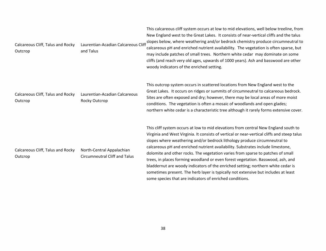
38
Calcareous Cliff, Talus and Rocky
Outcrop
Laurentian‐Acadian Calcareous Cliff
and Talus
This calcareous cliff system occurs at low to mid elevations, well below treeline, from
New England west to the Great Lakes. It consists of near‐vertical cliffs and the talus
slopes below, where weathering and/or bedrock chemistry produce circumneutral to
calcareous pH and enriched nutrient availability. The vegetation is often sparse, but
may include patches of small trees. Northern white cedar may dominate on some
cliffs (and reach very old ages, upwards of 1000 years). Ash and basswood are other
woody indicators of the enriched setting.
Calcareous Cliff, Talus and Rocky
Outcrop
Laurentian‐Acadian Calcareous
Rocky Outcrop
This outcrop system occurs in scattered locations from New England west to the
Great Lakes. It occurs on ridges or summits of circumneutral to calcareous bedrock.
Sites are often exposed and dry; however, there may be local areas of more moist
conditions. The vegetation is often a mosaic of woodlands and open glades;
northern white cedar is a characteristic tree although it rarely forms extensive cover.
Calcareous Cliff, Talus and Rocky
Outcrop
North‐Central Appalachian
Circumneutral Cliff and Talus
This cliff system occurs at low to mid elevations from central New England south to
Virginia and West Virginia. It consists of vertical or near‐vertical cliffs and steep talus
slopes where weathering and/or bedrock lithology produce circumneutral to
calcareous pH and enriched nutrient availability. Substrates include limestone,
dolomite and other rocks. The vegetation varies from sparse to patches of small
trees, in places forming woodland or even forest vegetation. Basswood, ash, and
bladdernut are woody indicators of the enriched setting; northern white cedar is
sometimes present. The herb layer is typically not extensive but includes at least
some species that are indicators of enriched conditions.

39
Central Appalachian Alkaline Glade
and Woodland
This system occurs at low to moderate elevations from the Central Appalachians
down into the Ridge and Valley. It consists of woodlands and open glades on thin
soils over limestone, dolostone or similar calcareous rock. In some cases, the
woodlands grade into closed‐canopy forests. Red‐cedar is a common tree, filling in in
the absence of fire, and chinquapin oak is indicative of the limestone substrate.
Prairie grasses are the dominant herbs (big bluestem, Indian grass, little bluestem,
grama); forb richness is often high. Fire is sometimes an important natural
disturbance vector, but open physiognomies may also be maintained by drought and
landslides.
Central Appalachian Dry Oak‐Pine
Forest
Central Appalachian Dry Oak‐Pine
Forest
These oak and oak‐pine forests cover large areas in the Central Appalachians and
northern Piedmont, with a more limited range in New England and north to the
Champlain Valley. The low‐ to mid‐elevation setting ranges from rolling hills to steep
slopes, with occasional occurrences on more level, ancient alluvial fans. The soils are
coarse and infertile; they may be deep (on glacial deposits in the northern part of the
system's range), or more commonly shallow, on rocky slopes of acidic rock. The well‐
drained soils and exposure create dry conditions. The forest is mostly closed‐canopy
but can include patches of more open woodlands. It is dominated by a variable
mixture of dry‐site oak and pine species such as chestnut oak, white oak, red oak,
black oak, scarlet oak, pitch pine, and white pine. The system may include areas of
oak forest, pine forest (usually small), and mixed oak‐pine forest. A heath shrub layer
(hillside blueberry, huckleberry, and mountain laurel, etc.), often dense, is
characteristic. Small hillslope pockets with impeded drainage may support small
isolated wetlands with red maple and black gum characteristic. Disturbance agents
include fire, windthrow, and ice damage. Increased site disturbance generally leads
to secondary forest vegetation with a greater proportion of Virginia pine and weedy
hardwoods such as red maple. In the absence of fire, this system is believed to
succeed to northern hardwood and hemlock forests.

40
Central Appalachian Dry Oak‐Pine
Forest
Central Appalachian Pine‐Oak
Rocky Woodland
This system of the Central Appalachians encompasses open or sparsely wooded
hilltops and outcrops or rocky slopes, mostly at lower elevations, but occasionally up
to 4000 feet in West Virginia. The substrate rock is granitic or of other acidic
lithology, including traprock in New England. The vegetation is patchy, with
woodland as well as open portions. Pitch and/or Virginia pines are diagnostic and
often are mixed with dry‐site oaks (including black oak and scarlet oak) and sprouts
of chestnut. Some areas have a fairly well‐developed heath shrub layer, others a
graminoid layer. Conditions are dry and nutrient‐poor, and at many, if not most,
sites, a history of fire is evident.
Central Appalachian Floodplain
Forest
This system encompasses floodplains of rivers in Atlantic drainages from southern
New England to Virginia. It is most common on medium to large rivers, but can occur
on smaller rivers where the stream gradient is low and a broad floodplain develops.
It can include a complex of wetland and upland vegetation on deep alluvial deposits,
on depositional bars, and (rarely) on bedrock where rivers cut through resistant
geology. This complex includes floodplain forests in which silver maple, sycamore,
and cottonwood are characteristic, as well as herbaceous sloughs, shrub wetlands,
riverside prairies and woodlands. Most areas are underwater each spring;
microtopography determining how long the various habitats are inundated.
Depositional and erosional features may both be present depending on the
particular floodplain.
Laurentian‐ N. Appalachian‐Boreal
Peatland Boreal‐Laurentian Bog
These raised peatlands are found at the near‐boreal latitudes of glaciated
northeastern and north‐central United States and adjacent Canada, where climate
allows the rate of peat accumulation to exceed its decomposition, resulting in acidic
peatlands. The surface of the bog typically is over the water table (ombrotrophic).
Peat mosses form the substrate. Black spruce and larch are the characteristic trees;
they are sparse to patchy, with the vegetation dominated by low heath shrubs
(sheep laurel, bog laurel, Labrador tea, leatherleaf) and patches of sedge and
bryophyte lawns. Typical forbs include sundews, pitcher plants, and several orchids.
While the raised portion defines these bogs, fen vegetation is often present along

41
the wetter perimeter.
Laurentian‐ N. Appalachian‐Boreal
Peatland
Boreal‐Laurentian‐Acadian Acidic
Basin Fen
Almost intermediate between a marsh and a bog, these fens develop in relatively
shallow basins with nutrient‐poor and acidic conditions. They are common across
the glaciated Northeast. Many occur in association with lakes or streams; some occur
as kettlehole fens (usually called kettlehole "bogs") associated with eskers or other
glacial deposits. These fens often form a floating peat‐based mat over water. The
substrate is peat moss, and vegetation typically includes patches of grass/sedge and
dwarf‐shrub dominance. Leatherleaf is usually present and often dominant. North of
46 N latitude, distinctive ribbed fens may be found in which a pattern of narrow low
ridges are oriented at right angles to the direction of the drainage, with wetter pools
or depressions between the ridges.

42
Laurentian‐ N. Appalachian‐Boreal
Peatland
North‐Central Interior and
Appalachian Acidic Peatland
These open “bogs” occur in basins south of the coldest regions of the Northeast
down to near the glacial boundary. They are found mostly in areas where glacial
stagnation left coarse deposits and glacial depressions (many are "kettleholes"). The
basins are generally closed, i.e., without inlets or outlets of surface water. The
nutrient‐poor substrate and the reduced throughflow of water create conditions
fostering the development of peat and peatland vegetation. In deeper basins, the
vascular vegetation grows on a peat mat over water, with no mineral soil
development. Heath shrubs and dwarf‐shrubs (e.g., leatherleaf) dominate, with
patches of sedges and forbs. Some peatlands may have a sparse tree layer. Although
these are often called bogs, in most cases they are technically fens (albeit nutrient‐
poor ones), as the vegetation remains in contact with the groundwater.
Laurentian‐Acadian Floodplain
Forest
Laurentian‐Acadian Floodplain
Forest & Eastern Boreal Floodplain
These floodplains occur in the northeastern U.S. north of the range of sycamore.
Most occur along medium to large rivers where topography and process have
resulted in the development of a complex of upland and wetland, temperate, alluvial
vegetation. This complex includes silver maple floodplain forests as well as
herbaceous sloughs and shrub wetlands. Most areas are underwater each spring, the
length of inundation dependent on both overall water level and local
microtopography. Associated trees include red maple and musclewood, the latter
frequent but never abundant. On terraces or in higher‐pH areas, sugar maple or red
oak may be locally prominent, with yellow birch and ash associates. Black willow is
characteristic of the levees adjacent to the channel. The herb layer often features
abundant spring ephemerals, giving way to fern dominance in many areas by mid‐
summer. Non‐forested wetlands associated with these systems include shrubby or
sedge/grass vegetation. Two uncommon expressions occur along sub‐boreal rivers in
northernmost New England, north of the range of silver maple: ice‐scour rivershores
dominated by diverse herb and shrub associations, and boreal floodplain forests
characterized by balsam poplar.
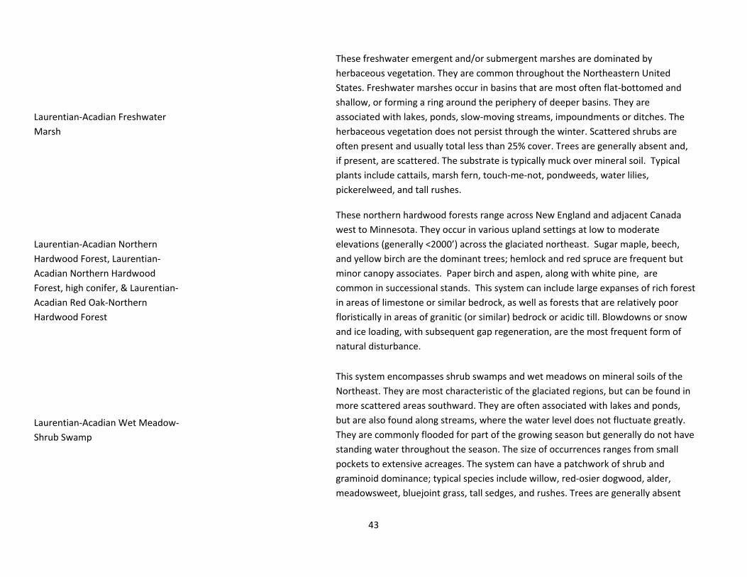
43
Laurentian‐Acadian Freshwater
Marsh
These freshwater emergent and/or submergent marshes are dominated by
herbaceous vegetation. They are common throughout the Northeastern United
States. Freshwater marshes occur in basins that are most often flat‐bottomed and
shallow, or forming a ring around the periphery of deeper basins. They are
associated with lakes, ponds, slow‐moving streams, impoundments or ditches. The
herbaceous vegetation does not persist through the winter. Scattered shrubs are
often present and usually total less than 25% cover. Trees are generally absent and,
if present, are scattered. The substrate is typically muck over mineral soil. Typical
plants include cattails, marsh fern, touch‐me‐not, pondweeds, water lilies,
pickerelweed, and tall rushes.
Laurentian‐Acadian Northern
Hardwood Forest, Laurentian‐
Acadian Northern Hardwood
Forest, high conifer, & Laurentian‐
Acadian Red Oak‐Northern
Hardwood Forest
These northern hardwood forests range across New England and adjacent Canada
west to Minnesota. They occur in various upland settings at low to moderate
elevations (generally <2000’) across the glaciated northeast. Sugar maple, beech,
and yellow birch are the dominant trees; hemlock and red spruce are frequent but
minor canopy associates. Paper birch and aspen, along with white pine, are
common in successional stands. This system can include large expanses of rich forest
in areas of limestone or similar bedrock, as well as forests that are relatively poor
floristically in areas of granitic (or similar) bedrock or acidic till. Blowdowns or snow
and ice loading, with subsequent gap regeneration, are the most frequent form of
natural disturbance.
Laurentian‐Acadian Wet Meadow‐
Shrub Swamp
This system encompasses shrub swamps and wet meadows on mineral soils of the
Northeast. They are most characteristic of the glaciated regions, but can be found in
more scattered areas southward. They are often associated with lakes and ponds,
but are also found along streams, where the water level does not fluctuate greatly.
They are commonly flooded for part of the growing season but generally do not have
standing water throughout the season. The size of occurrences ranges from small
pockets to extensive acreages. The system can have a patchwork of shrub and
graminoid dominance; typical species include willow, red‐osier dogwood, alder,
meadowsweet, bluejoint grass, tall sedges, and rushes. Trees are generally absent

44
and, if present, are scattered.
North Atlantic Coastal Plain Basin
Peat Swamp
This system of the coastal plain from Massachusetts south to Virginia is comprised of
acidic peat swamps formed in basins of various sizes. Atlantic white cedar is
characteristic and often dominant; red maple may also be an important species,
especially after logging. The saturated hydrology is evidenced by Sphagnum‐based
hummock‐and‐hollow microtopography.
North Atlantic Coastal Plain
Hardwood Forest
This system is comprised of dry hardwood forests largely dominated by oaks, ranging
from sandy glacial and outwash deposits of Cape Cod and Long Island south through
the coastal plain of Maryland and Virginia (to about the James River). White, red,
chestnut, and scarlet oaks are typical, and holly is sometimes present. Sassafras,
birch, aspen, and hazelnut are common associates in earlier‐successional areas. In
the northern half of the range, conditions can grade to dry‐mesic, reflected in the
local abundance of beech . These forests occur on acidic, sandy to gravelly soils with
a thick duff layer, often with a heath shrub layer.

45
North Atlantic Coastal Plain
Maritime Forest
This system encompasses a range of woody vegetation present on barrier islands and
near‐coastal strands, from southeastern Virginia (Virginia Beach) northward along
the extent of the Atlantic Coastal Plain. It includes forests and shrublands whose
structure and composition are influenced by proximity to marine environments,
including both upland and wetlands. Vegetation includes narrow bands of forests,
often featuring stunted trees with contorted branches and dense vine layers. A range
of trees may be present depending upon actual location and degree of protection
from most extreme maritime influences.
North‐Central Appalachian Pine
Barrens
These pine barrens occur on glacial sandplains of inland regions of New England and
New York, as well as some occurrences in the coastal plain north of Cape Cod and a
disjunct area in the Poconos. Substrates include outwash plains, stabilized sand
dunes, and glacial till. The soils are consequently coarse‐textured, acidic, well‐
drained to xeric, and low in nutrients. Pitch pine is the usual dominant; open
woodland is the typical cover but some include patches of closed‐canopy forest.
Red oak, white pine, and gray birch are common associates. A tall‐shrub layer of
scrub oak or dwarf chinkapin oak is commonly present. A well‐developed low‐shrub
layer is typical, with lowbush blueberry, huckleberry, and sweetfern characteristic.
The barrens are often a physiognomic patchwork, ranging from nearly closed‐canopy
forest to open pine woodlands, to scrub oak shrublands, to herbaceous/dwarf‐shrub
frost pockets. Small changes in elevation can create pockets with saturated soil,
where shrubs such as hazelnut, buttonbush, highbush blueberry, and alder can form
dense cover. Grassy areas dominated by little bluestem with native wild lupine,
bushclover, and other forbs provide habitat for several rare invertebrates including
the Karner blue butterfly and frosted elfin. Important vertebrate species include the
hognose snake, whippoorwill, nighthawk, pine barrens treefrog, and others. These
barrens always have a history of recurrent fires, and fire is required to maintain
them.

46
North‐Central Interior Wet
Flatwoods
This small‐patch system is found throughout the northern glaciated Midwest ranging
east into Lower New England and the Champlain Valley. It usually occurs on poorly
drained uplands or in depressions associated with glacial features such as tillplains,
lakeplains or outwash plains. Soils often have an impermeable clay layer that can
create a shallow, perched water table. Saturation can vary, with ponding common
during wetter seasons, and drought possible during the summer and autumn
months. These fluctuating moisture levels can lead to complexes of forest upland
and wetland species occurring within this system. Pin oak dominates in many areas;
other common trees (sometimes dominant) include swamp white oak, bur oak,
and/or red maple. Areas with more dense tree cover have less shrub and
herbaceous cover, while those with moderate tree canopy cover tend to have a
dense understory. Some common species include buttonbush, winterberry, alder,
and sedges. Flooding, drought and fire can influence this system.

47
Northeastern Coastal and Interior
Pine‐Oak Forest
(Same description as Central
Appalachian Dry Oak‐Pine Forest)
These oak and oak‐pine forests cover large areas in the Central Appalachians and
northern Piedmont, with a more limited range in New England and north to the
Champlain Valley. The low‐ to mid‐elevation setting ranges from rolling hills to steep
slopes, with occasional occurrences on more level, ancient alluvial fans. The soils are
coarse and infertile; they may be deep (on glacial deposits in the northern part of the
system's range), or more commonly shallow, on rocky slopes of acidic rock. The well‐
drained soils and exposure create dry conditions. The forest is mostly closed‐canopy
but can include patches of more open woodlands. It is dominated by a variable
mixture of dry‐site oak and pine species such as chestnut oak, white oak, red oak,
black oak, scarlet oak, pitch pine, and white pine. The system may include areas of
oak forest, pine forest (usually small), and mixed oak‐pine forest. A heath shrub layer
(hillside blueberry, huckleberry, and mountain laurel, etc.), often dense, is
characteristic. Small hillslope pockets with impeded drainage may support small
isolated wetlands with red maple and black gum characteristic. Disturbance agents
include fire, windthrow, and ice damage. Increased site disturbance generally leads
to secondary forest vegetation with a greater proportion of Virginia pine and weedy
hardwoods such as red maple. In the absence of fire, this system is believed to
succeed to northern hardwood and hemlock forests.
Northern Appalachian‐Acadian
Conifer‐Hardwood Acidic Swamp
Northern Appalachian‐Acadian
Conifer‐Hardwood Acidic Swamp
These forested wetlands are common in the glaciated Northeast. They occur on
mineral soils (sometimes with a thin to moderate upper layer of peat) that are
nutrient‐poor. These basin wetlands remain saturated for all or nearly all of the
growing season, and may have standing water seasonally. Red maple, red spruce,
and balsam fir are the most typical trees; ash may be common in some locations.
The herbaceous and shrub layers tend to be fairly species‐poor; catberry, tall ferns
(cinnamon, interrupted, sensitive), and wetland sedges are typical and may be
extensive.

48
Northern Appalachian‐Acadian
Conifer‐Hardwood Acidic Swamp
North‐Central Appalachian Acidic
Swamp
These swamps are distributed from central New England through the Central
Appalachians south to Virginia and west to Ohio. They are found at low to mid
elevations (generally <2000’) in poorly drained depressions. The acidic substrate is
mineral soil, often with a component of organic muck; if peat is present, it usually
forms a thin layer over the mineral soil rather than a true peat substrate. Hemlock is
usually present and may be dominant. It is often mixed with deciduous wetland trees
such as red maple or black gum. Basin swamps tend to be more nutrient‐poor than
seepage swamps; in some settings, the two occur adjacent to each other with the
basin swamp vegetation surrounded by seepage swamp vegetation on its upland
periphery.
Northern Atlantic Coastal Plain
Dune and Swale/Sandy Beach
This system includes sparsely vegetated sand beaches along the northeast coast.
They generally extend seaward from foredunes but may include flats behind
breached foredunes. Although these habitats are situated just above the mean high
tide limit, they are constantly impacted by waves and may be flooded by high spring
tides and storm surges. Constant salt spray and rainwater maintain generally moist
conditions. Substrates consist of unconsolidated sand and shell sediments that are
constantly shifted by winds and floods. Dynamic disturbance regimes largely limit
vegetation to pioneering, salt‐tolerant, succulent annuals. Sea‐rocket and Russian
thistle are usually most numerous and characteristic, with other scattered maritime
environment associates.

49
Tidal Marsh
North Atlantic Coastal Plain Tidal
Salt Marsh:
salt/brackish/oligohaline
This system encompasses the intertidal marshes of the North Atlantic Coastal Plain
from Chesapeake Bay north to Cape Cod, and sporadically to the southern Maine
coast. It includes a number of different broad vegetation types including salt pannes,
salt marshes, and salt shrublands. This system occurs on the bay side of barrier
beaches and the outer mouth of tidal rivers where salinity is not much diluted by
freshwater input. The typical salt marsh profile, from sea to land, features a low
regularly flooded marsh strongly dominated by salt marsh cordgrass; a higher
irregularly flooded marsh dominated by saltmeadow cordgrass and saltgrass; low
hypersaline pannes characterized by saltwort; and a salt scrub ecotone
characterized by marsh elder, groundsel‐tree, and switchgrass. Salt marsh "islands"
of slightly higher elevation also support red‐cedar. For the purposes of this
classification, these include the uncommon salt ponds sometimes found behind
barrier beaches, which are treated elsewhere as a separate system (Northern
Atlantic Coastal Plain Salt Pond Marsh).
Tidal Marsh Acadian Coastal Salt Marsh,
Acadian Estuary Marsh
This system covers saltwater marshes of the Gulf of Maine along the immediate
ocean shore and near estuary mouths. Sometimes called "salt meadows," these
marshes display strong graminoid dominance, with patchy forbs. Salt hay and
smooth cordgrass are the major dominants. These marshes may be extensive where
the local topography allows; however, they are generally not associated with sand
beach and dune systems, being more characteristic of the primarily rocky portions of
the Gulf of Maine coast. Where the coastal topography becomes more dissected,
they are commonly seen as a fairly narrow fringe along tidal shorelines. For the
purposes of this classification, these include the uncommon salt ponds sometimes
found behind barrier beaches, which are treated elsewhere as a separate system
(Northern Atlantic Coastal Plain Salt Pond Marsh).

50
Tidal Marsh Acadian Estuary Marsh
These marshes are found along brackish estuaries of the Gulf of Maine, and include
both emergent and submergent vegetation. Dominance ranges from extensive
bulrush beds and tall grasses and sedges to sparsely vegetated mudflats, all tidally
influenced. These marshes grade into the salt marsh system at the mouth of
estuaries.

51
Appendix3.DetailsofEcologicalSystemRepresentationperEcologicalSection
A. Number of unique patches of each ecological system, over 1km apart from a similar system of the same type; B. total acres of each ecological system and
acres and percent of each ecological system conserved; C. Proportion of conserved lands and all lands occupied by each ecological system [(acres of each
ecological system)/(total acres conserved or total acres)]; and D. Representation of ecological systems in conserved land. Both proportional [AR = adequately
represented; UR = under represented; and NR = not represented] and plurality [P = occurs plurally; NP = does not occur plurally, i.e. only one example has been
conserved within the biophysical section] analyses are described. Where no description is given, the system is adequately represented (proportionally) and
occurs plurally. All analyses were done by first filtering ‘quality’ examples of ecological systems based on acreage, and were performed for both Type 1 (Gap
status 1,2 and3) and Type 2 (Gap status 1 and 2 only).

52
A. # unique patches B. Acres C. relative % of total area D. Cons. Lands Rep.
Type 1
Cons. Land
Type 2
Cons. Land
All land
area
Type 1 Cons.
Land (%)
Type 2 Cons.
Land (%)
All land
area
Type 1
Cons. Land
Type 2
Cons. Land
All land
area Type 1 Type 2
Aroostook Hills and Lowlands 206 38 1641 137,850
(10.45%)
10,777
(0.82%) 1,319,475 65.4% 53.7% 55.4%
Acadian Low Elevation Spruce‐Fir‐Hardwood Forest 3 2 51 72,727
(11.14%)
4,516
(0.69%) 652,825 34.5% 22.5% 27.4%
Acadian Sub‐boreal Spruce Flat 25 3 190 18,648
(19.86%)
1,328
(1.41%) 93,880 8.8% 6.6% 3.9%
Acidic Cliff, Talus and Rocky Outcrop 7 1 69 162 (8.51%) 129 (6.77%) 1,905 0.1% 0.6% 0.1%
AR‐NP
Alkaline Conifer‐Hardwood Swamp 26 6 154 3,036
(3.42%) 764 (0.86%) 88,790 1.4% 3.8% 3.7% UR‐P
Calcareous Cliff, Talus and Rocky Outcrop 7 2 60 237
(14.06%) 36 (2.11%) 1,685 0.1% 0.2% 0.1%
Laurentian‐ N. Appalachian‐Boreal Peatland 23 3 106 3,229
(14.74%) 553 (2.52%) 21,902 1.5% 2.8% 0.9%
Laurentian‐Acadian Floodplain Forest 4 2 47 298
(12.65%)
256
(10.88%) 2,355 0.1% 1.3% 0.1%
Laurentian‐Acadian Freshwater Marsh 21 7 216 840
(12.86%) 343 (5.25%) 6,530 0.4% 1.7% 0.3%
Laurentian‐Acadian Northern Hardwood Forest 10 1 92 20,267
(6.63%) 306 (0.1%) 305,630 9.6% 1.5% 12.8%
UR‐NP

53
Laurentian‐Acadian Northern Hardwood Forest, high conifer 16 2 117 9,995
(13.85%)
1,769
(2.45%) 72,151 4.7% 8.8% 3.0%
Laurentian‐Acadian Red Oak‐Northern Hardwood Forest
3 0 (0%) 0 (0%) 1,553
0.1% NR NR
Laurentian‐Acadian Wet Meadow‐Shrub Swamp 37 8 348 2,102
(11.48%) 515 (2.81%) 18,310 1.0% 2.6% 0.8%
Northern Appalachian‐Acadian Conifer‐Hardwood Acidic Swamp 27 1 188 6309
(12.14%) 263 (0.51%) 51,960 3.0% 1.3% 2.2%
AR‐NP
Boundary Plateau and St. John Uplands 1036 142 2638 917,478
(36.12%)
47,769
(1.88%) 2,540,260 69.6% 50.0% 72.3%
Acadian Low Elevation Spruce‐Fir‐Hardwood Forest 14 2 33 415,089
(39.77%)
23,558
(2.26%) 1,043,676 31.5% 24.7% 29.7%
Acadian Sub‐boreal Spruce Flat 156 23 345 86,643
(45.26%)
6,418
(3.35%) 191,438 6.6% 6.7% 5.4%
Acadian‐Appalachian Montane Spr‐Fir‐Hwd Forest
1 0 (0%) 0 (0%) 304
0.0% NR NR
Acidic Cliff, Talus and Rocky Outcrop 117 6 517 3,126 (25%) 748 (5.98%) 12,503 0.2% 0.8% 0.4%
Alkaline Conifer‐Hardwood Swamp 76 10 157 12,274
(34.61%) 477 (1.35%) 35,463 0.9% 0.5% 1.0%
UR‐P
Calcareous Cliff, Talus and Rocky Outcrop 63 2 142 1,024
(37.44%) 25 (0.91%) 2,734 0.1% 0.0% 0.1%
UR‐P
Laurentian‐ N. Appalachian‐Boreal Peatland 67 9 138 14,469
(46.38%)
2,115
(6.78%) 31,201 1.1% 2.2% 0.9%
Laurentian‐Acadian Floodplain Forest 14 4 21 445
(56.19%)
135
(17.05%) 792 0.0% 0.1% 0.0%
Laurentian‐Acadian Freshwater Marsh 93 30 214 4,943
(43.41%)
1,532
(13.45%) 11,387 0.4% 1.6% 0.3%

54
Laurentian‐Acadian Northern Hardwood Forest 53 4 113 297,450
(33.04%)
5,018
(0.56%) 900,392 22.6% 5.3% 25.6%
UR‐P
Laurentian‐Acadian Northern Hardwood Forest, high conifer 84 4 245 46,348
(20.85%)
1,973
(0.89%) 222,318 3.5% 2.1% 6.3%
UR‐P
Laurentian‐Acadian Wet Meadow‐Shrub Swamp 160 34 362 7,356
(38.46%)
1,652
(8.64%) 19,127 0.6% 1.7% 0.5%
Northern Appalachian‐Acadian Conifer‐Hardwood Acidic Swamp 139 14 350 28,312
(41.08%)
4,118
(5.97%) 68,926 2.1% 4.3% 2.0%
Casco Bay ‐ Penobscot Bay ‐ Central Interior 372 183 3381 84,705
(4.44%)
39,485
(2.07%) 1,906,300 45.9% 49.1% 52.3%
Acadian Low Elevation Spruce‐Fir‐Hardwood Forest 6 4 74 3,767
(2.55%)
2,339
(1.59%) 147,503 2.0% 2.9% 4.0%
Acadian Maritime Bog
3 0 (0%) 0 (0%) 280
0.0% NR NR
Acadian Sub‐boreal Spruce Flat 9 7 125 782 (3.83%) 594 (2.9%) 20,436 0.4% 0.7% 0.6%
Acadian‐North Atlantic Rocky Coast 23 10 60 324
(15.16%) 133 (6.23%) 2,140 0.2% 0.2% 0.1%
Acidic Cliff, Talus and Rocky Outcrop 23 12 82 441
(25.84%)
351
(20.58%) 1,706 0.2% 0.4% 0.0%
Alkaline Conifer‐Hardwood Swamp 81 38 524 10,329
(6.99%)
5,386
(3.65%) 147,704 5.6% 6.7% 4.1%
Appalachian‐Acadian Pine‐Hemlock‐Hardwood Forest 2 1 47 31,916
(2.84%)
11,762
(1.05%) 1,123,013 17.3% 14.6% 30.8%
UR‐NP
Calcareous Cliff, Talus and Rocky Outcrop 6 2 52 38 (6.67%) 13 (2.33%) 565 0.0% 0.0% 0.0%
Central Appalachian Dry Oak‐Pine Forest 2 1 45 25 (2.7%) 12 (1.27%) 931 0.0% 0.0% 0.0%

55
Laurentian‐ N. Appalachian‐Boreal Peatland 23 12 122 11,957
(19.87%)
8,599
(14.29%) 60,165 6.5% 10.7% 1.7%
Laurentian‐Acadian Floodplain Forest 10 3 105 298 (3.87%) 44 (0.58%) 7,705 0.2% 0.1% 0.2%
UR‐P
Laurentian‐Acadian Freshwater Marsh 79 33 876 3,156
(7.03%) 1,346 (3%) 44,893 1.7% 1.7% 1.2%
Laurentian‐Acadian Northern Hardwood Forest 4 3 113 3,506
(3.77%)
1,136
(1.22%) 92,972 1.9% 1.4% 2.5%
Laurentian‐Acadian Northern Hardwood Forest, high conifer
7 0 (0%) 0 (0%) 2,849
0.1% NR NR
Laurentian‐Acadian Red Oak‐Northern Hardwood Forest 8 2 96 10,646
(6.65%)
4,399
(2.75%) 160,191 5.8% 5.5% 4.4%
Laurentian‐Acadian Wet Meadow‐Shrub Swamp 55 25 772 2,771
(6.22%) 872 (1.96%) 44,579 1.5% 1.1% 1.2%
North Atlantic Coastal Plain Maritime Forest 10 10 26 1,558
(9.21%) 961 (5.68%) 16,923 0.8% 1.2% 0.5%
Northern Appalachian‐Acadian Conifer‐Hardwood Acidic Swamp 7 5 136 851 (3.97%) 596 (2.78%) 21,434 0.5% 0.7% 0.6%
Northern Atlantic Coastal Plain Dune and Swale/Sandy Beach 8 6 46 205
(18.64%)
177
(16.06%) 1,102 0.1% 0.2% 0.0%
Tidal Marsh 16 9 70 2,134
(23.18%) 765 (8.31%) 9,206 1.2% 1.0% 0.3%
Central ‐ Western ‐ White Mountains 1158 354 3683 883,761
(29.24%)
266,953
(8.83%) 3,022,392 71.1% 73.0% 71.4%
Acadian Low Elevation Spruce‐Fir‐Hardwood Forest 35 10 118 277,152
(40.75%)
79,800
(11.73%) 680,108 22.3% 21.8% 16.1%
Acadian Sub‐boreal Spruce Flat 140 32 347 30,337
(38.78%)
5,999
(7.67%) 78,226 2.4% 1.6% 1.8%

56
Acadian‐Appalachian Alpine Tundra 9 6 9 3,550
(99.04%)
2,472
(68.94%) 3,585 0.3% 0.7% 0.1%
Acadian‐Appalachian Montane Spr‐Fir‐Hwd Forest 38 26 67 143,846
(36.52%)
61,491
(15.61%) 393,850 11.6% 16.8% 9.3%
Acidic Cliff, Talus and Rocky Outcrop 267 97 821 26,401
(45.55%)
17,047
(29.41%) 57,966 2.1% 4.7% 1.4%
Alkaline Conifer‐Hardwood Swamp 93 18 387 9,019
(26.97%) 882 (2.64%) 33,444 0.7% 0.2% 0.8%
UR‐P
Appalachian‐Acadian Pine‐Hemlock‐Hardwood Forest 5 1 32 9,680
(4.76%) 954 (0.47%) 203,295 0.8% 0.3% 4.8% UR‐P UR‐P
Calcareous Cliff, Talus and Rocky Outcrop 72 24 271 3,720 (33%) 1,756
(15.58%) 11,272 0.3% 0.5% 0.3%
Central Appalachian Dry Oak‐Pine Forest 4
24 72 (19.54%) 0 (0%) 370 0.0%
0.0%
NR
Laurentian‐ N. Appalachian‐Boreal Peatland 32 5 83 10,014
(56.61%)
4,241
(23.97%) 17,689 0.8% 1.2% 0.4%
Laurentian‐Acadian Floodplain Forest 9 5 46 494
(17.51%) 242 (8.58%) 2,819 0.0% 0.1% 0.1%
Laurentian‐Acadian Freshwater Marsh 98 28 337 2,606
(28.63%) 651 (7.15%) 9,105 0.2% 0.2% 0.2%
Laurentian‐Acadian Northern Hardwood Forest 47 17 115 259,621
(23.12%)
55,864
(4.97%) 1,122,975 20.9% 15.3% 26.5%
Laurentian‐Acadian Northern Hardwood Forest, high conifer 83 20 246 73,369
(37.49%)
27,567
(14.09%) 195,704 5.9% 7.5% 4.6%
Laurentian‐Acadian Red Oak‐Northern Hardwood Forest 10 3 54 15,776
(10.32%)
2,172
(1.42%) 152,872 1.3% 0.6% 3.6% UR‐P UR‐P
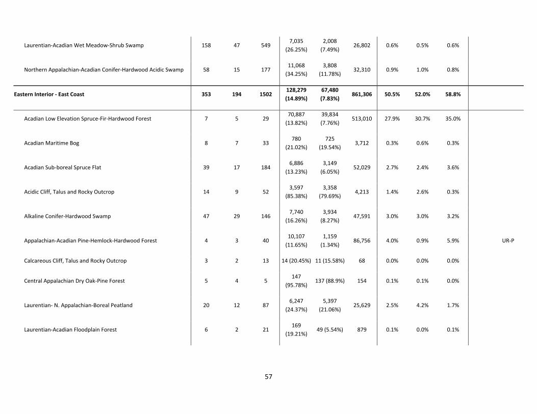
57
Laurentian‐Acadian Wet Meadow‐Shrub Swamp 158 47 549 7,035
(26.25%)
2,008
(7.49%) 26,802 0.6% 0.5% 0.6%
Northern Appalachian‐Acadian Conifer‐Hardwood Acidic Swamp 58 15 177 11,068
(34.25%)
3,808
(11.78%) 32,310 0.9% 1.0% 0.8%
Eastern Interior ‐ East Coast 353 194 1502 128,279
(14.89%)
67,480
(7.83%) 861,306 50.5% 52.0% 58.8%
Acadian Low Elevation Spruce‐Fir‐Hardwood Forest 7 5 29 70,887
(13.82%)
39,834
(7.76%) 513,010 27.9% 30.7% 35.0%
Acadian Maritime Bog 8 7 33 780
(21.02%)
725
(19.54%) 3,712 0.3% 0.6% 0.3%
Acadian Sub‐boreal Spruce Flat 39 17 184 6,886
(13.23%)
3,149
(6.05%) 52,029 2.7% 2.4% 3.6%
Acidic Cliff, Talus and Rocky Outcrop 14 9 52 3,597
(85.38%)
3,358
(79.69%) 4,213 1.4% 2.6% 0.3%
Alkaline Conifer‐Hardwood Swamp 47 29 146 7,740
(16.26%)
3,934
(8.27%) 47,591 3.0% 3.0% 3.2%
Appalachian‐Acadian Pine‐Hemlock‐Hardwood Forest 4 3 40 10,107
(11.65%)
1,159
(1.34%) 86,756 4.0% 0.9% 5.9%
UR‐P
Calcareous Cliff, Talus and Rocky Outcrop 3 2 13 14 (20.45%) 11 (15.58%) 68 0.0% 0.0% 0.0%
Central Appalachian Dry Oak‐Pine Forest 5 4 5 147
(95.78%) 137 (88.9%) 154 0.1% 0.1% 0.0%
Laurentian‐ N. Appalachian‐Boreal Peatland 20 12 87 6,247
(24.37%)
5,397
(21.06%) 25,629 2.5% 4.2% 1.7%
Laurentian‐Acadian Floodplain Forest 6 2 21 169
(19.21%) 49 (5.54%) 879 0.1% 0.0% 0.1%

58
Laurentian‐Acadian Freshwater Marsh 89 48 354 4,423
(25.72%)
2,982
(17.34%) 17,195 1.7% 2.3% 1.2%
Laurentian‐Acadian Northern Hardwood Forest 7 3 41 2,720
(8.65%)
1,188
(3.78%) 31,449 1.1% 0.9% 2.1% UR‐P UR‐P
Laurentian‐Acadian Northern Hardwood Forest, high conifer 1
5 341
(25.07%) 0 (0%) 1,359 0.1%
0.1% AR‐NP NR
Laurentian‐Acadian Red Oak‐Northern Hardwood Forest 10 3 48 7,705
(20.91%)
2,679
(7.27%) 36,844 3.0% 2.1% 2.5%
Laurentian‐Acadian Wet Meadow‐Shrub Swamp 67 34 305 4611
(22.01%)
1,584
(7.56%) 20,945 1.8% 1.2% 1.4%
Northern Appalachian‐Acadian Conifer‐Hardwood Acidic Swamp 15 9 102 1,608
(9.58%)
1,103
(6.57%) 16,780 0.6% 0.8% 1.1%
Tidal Marsh 11 7 37 298
(11.08%) 192 (7.13%) 2,692 0.1% 0.1% 0.2%
Eastern Lowlands ‐ Central Foothills 533 64 2884 337,765
(17.95%)
19,870
(1.06%) 1,881,200 66.3% 54.8% 61.8%
Acadian Low Elevation Spruce‐Fir‐Hardwood Forest 21 3 113 30,831
(7.7%) 1,596 (0.4%) 400,190 6.1% 4.4% 13.2% UR‐P UR‐P
Acadian Sub‐boreal Spruce Flat 44 3 311 8,188
(12.74%) 248 (0.39%) 64,246 1.6% 0.7% 2.1%
UR‐P
Acidic Cliff, Talus and Rocky Outcrop 38 4 118 659
(32.86%) 103 (5.12%) 2,007 0.1% 0.3% 0.1%
Alkaline Conifer‐Hardwood Swamp 31 7 219 33,587
(23.75%)
3,056
(2.16%) 141,400 6.6% 8.4% 4.6%
Appalachian‐Acadian Pine‐Hemlock‐Hardwood Forest 22 3 114 179,616
(26.3%) 6,861 (1%) 683,002 35.3% 18.9% 22.5%

59
Calcareous Cliff, Talus and Rocky Outcrop 5
46 27 (5.61%) 0 (0%) 476 0.0%
0.0% UR‐P NR
Laurentian‐ N. Appalachian‐Boreal Peatland 53 8 222 15,328
(23.38%) 2,885 (4.4%) 65,558 3.0% 8.0% 2.2%
Laurentian‐Acadian Floodplain Forest 16 4 61 976
(19.01%) 178 (3.47%) 5,132 0.2% 0.5% 0.2%
Laurentian‐Acadian Freshwater Marsh 92 7 529 5,650
(23.89%) 1,231 (5.2%) 23,656 1.1% 3.4% 0.8%
Laurentian‐Acadian Northern Hardwood Forest 33 1 170 37,583
(11.36%) 349 (0.11%) 330,797 7.4% 1.0% 10.9%
UR‐NP
Laurentian‐Acadian Northern Hardwood Forest, high conifer 11 1 104 4,702
(9.48%) 349 (0.7%) 49,620 0.9% 1.0% 1.6%
Laurentian‐Acadian Red Oak‐Northern Hardwood Forest 7
42 3,905
(17.81%) 0 (0%) 21,923 0.8%
0.7%
NR
Laurentian‐Acadian Wet Meadow‐Shrub Swamp 124 18 656 11,720
(25.78%) 1,136 (2.5%) 45,458 2.3% 3.1% 1.5%
Northern Appalachian‐Acadian Conifer‐Hardwood Acidic Swamp 36 5 179 4,993
(10.46%)
1,879
(3.94%) 47,735 1.0% 5.2% 1.6%
Seacoast Plain ‐ Ossipee 201 90 1334 47,984
(7.05%)
11,423
(1.68%) 681,037 45.4% 38.3% 49.2%
Acadian‐North Atlantic Rocky Coast 8 6 22 117
(15.92%)
101
(13.82%) 733 0.1% 0.3% 0.1%
Acidic Cliff, Talus and Rocky Outcrop 8 5 49 245
(17.89%)
140
(10.23%) 1,372 0.2% 0.5% 0.1%
Alkaline Conifer‐Hardwood Swamp 22 15 131 3,854
(8.45%)
1,478
(3.24%) 45,620 3.7% 5.0% 3.3%
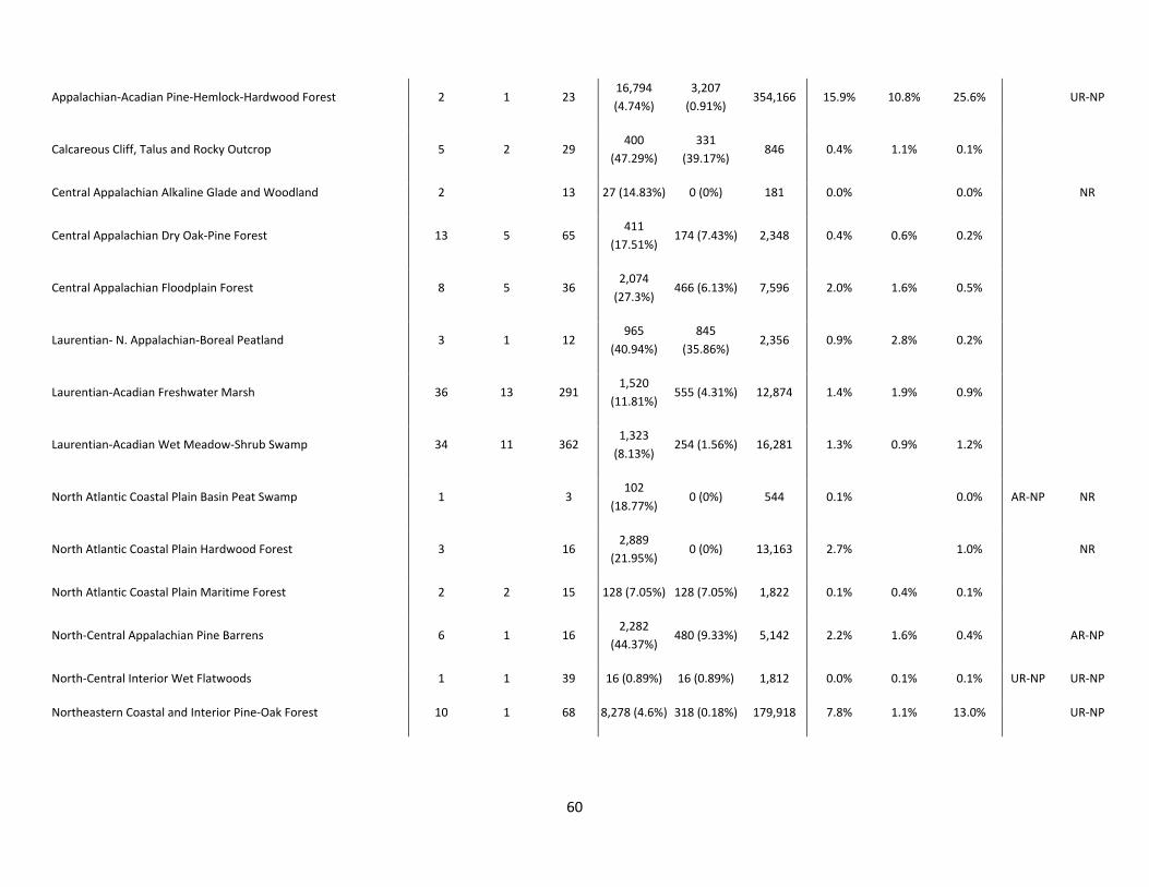
60
Appalachian‐Acadian Pine‐Hemlock‐Hardwood Forest 2 1 23 16,794
(4.74%)
3,207
(0.91%) 354,166 15.9% 10.8% 25.6%
UR‐NP
Calcareous Cliff, Talus and Rocky Outcrop 5 2 29 400
(47.29%)
331
(39.17%) 846 0.4% 1.1% 0.1%
Central Appalachian Alkaline Glade and Woodland 2
13 27 (14.83%) 0 (0%) 181 0.0%
0.0%
NR
Central Appalachian Dry Oak‐Pine Forest 13 5 65 411
(17.51%) 174 (7.43%) 2,348 0.4% 0.6% 0.2%
Central Appalachian Floodplain Forest 8 5 36 2,074
(27.3%) 466 (6.13%) 7,596 2.0% 1.6% 0.5%
Laurentian‐ N. Appalachian‐Boreal Peatland 3 1 12 965
(40.94%)
845
(35.86%) 2,356 0.9% 2.8% 0.2%
Laurentian‐Acadian Freshwater Marsh 36 13 291 1,520
(11.81%) 555 (4.31%) 12,874 1.4% 1.9% 0.9%
Laurentian‐Acadian Wet Meadow‐Shrub Swamp 34 11 362 1,323
(8.13%) 254 (1.56%) 16,281 1.3% 0.9% 1.2%
North Atlantic Coastal Plain Basin Peat Swamp 1
3 102
(18.77%) 0 (0%) 544 0.1%
0.0% AR‐NP NR
North Atlantic Coastal Plain Hardwood Forest 3
16 2,889
(21.95%) 0 (0%) 13,163 2.7%
1.0%
NR
North Atlantic Coastal Plain Maritime Forest 2 2 15 128 (7.05%) 128 (7.05%) 1,822 0.1% 0.4% 0.1%
North‐Central Appalachian Pine Barrens 6 1 16 2,282
(44.37%) 480 (9.33%) 5,142 2.2% 1.6% 0.4%
AR‐NP
North‐Central Interior Wet Flatwoods 1 1 39 16 (0.89%) 16 (0.89%) 1,812 0.0% 0.1% 0.1% UR‐NP UR‐NP
Northeastern Coastal and Interior Pine‐Oak Forest 10 1 68 8,278 (4.6%) 318 (0.18%) 179,918 7.8% 1.1% 13.0%
UR‐NP

61
Northern Appalachian‐Acadian Conifer‐Hardwood Acidic Swamp 17 6 99 2,302
(9.39%) 598 (2.44%) 24,512 2.2% 2.0% 1.8%
Northern Atlantic Coastal Plain Dune and Swale/Sandy Beach 8 5 19 160 (6.94%) 115 (5%) 2,300 0.2% 0.4% 0.2%
Tidal Marsh 12 10 26 4,096
(54.96%)
2,216
(29.74%) 7,453 3.9% 7.4% 0.5%