Embed Size (px)
Citation preview
A
rso
wustar©
K
1
1a
ds(mm(tEe
0d
Available online at www.sciencedirect.com
Landscape and Urban Planning 86 (2008) 47–59
A conceptual model of ecological connectivity in the ShellharbourLocal Government Area, New South Wales, Australia
Kellie Parker a, Lesley Head a,∗, Laurie A. Chisholm a, Nick Feneley b
a GeoQuEST Research Centre, School of Earth and Environmental Sciences,University of Wollongong, Northfields Avenue, Wollongong, NSW 2522, Australia
b Shellharbour City Council, PO Box 155, Shellharbour City Centre 2529, Australia
Received 13 September 2006; received in revised form 25 October 2007; accepted 17 December 2007Available online 20 February 2008
bstract
The conservation of biological diversity in landscapes dominated by human use is emerging as an increasingly significant challenge, given theate at which the Earth’s remaining vegetation resources are being lost. Whilst traditional approaches to conservation have relied upon the ability ofpecies to persist within the scattered fragments to which they have been confined, recent scientific evidence suggests that the long-term viabilityf fragmented populations may only be secured through the establishment of ecological connectivity between existing fragments.
In the absence of a suitable methodology within which to design connective habitat configurations, a conceptual approach to landscape designas devised for a highly urbanised environment within the Shellharbour Local Government Area (LGA), New South Wales (NSW). This approachtilises beneficial landscape attributes advocated in the literature, and tailors existing rapid assessment methodologies traditionally used to provide
imple measures of ecosystem health. Using this methodology, conservationally significant stepping-stone sites were identified between selectederminal habitat patches. The determination of an optimal corridor configuration linking these patches was found to heavily utilise riparian habitatnd adjacent residential yard space. Planting endemic species in these areas will support ecological flow by increasing the area of core habitatelative to edge habitat.2008 Elsevier B.V. All rights reserved.
abvaowF
tiHi
eywords: Urban; Fragments; Ecological connectivity; Rapid assessment
. Introduction
.1. Linking habitats to enhance biodiversity in developedreas
The current rate and intensity of the destruction and degra-ation of the Earth’s remaining vegetation resources poses aignificant threat to the conservation of biological diversityBennett, 2003; Pirnat, 2000; Marzluff and Ewing, 2001). Inany countries including Australia, entire landscapes have beenodified to accommodate for a range of anthropogenic activities
Marzluff and Ewing, 2001). Of these, urbanisation is considered
o exert the greatest local pressure on biodiversity (Marzluff andwing, 2001). This is due to the stark contrast between the urbannvironment and the pre-existing natural condition (Marzluff∗ Corresponding author.E-mail address: [email protected] (L. Head).
oa
amBt
169-2046/$ – see front matter © 2008 Elsevier B.V. All rights reserved.oi:10.1016/j.landurbplan.2007.12.007
nd Ewing, 2001). In such areas, the majority of the remainingiological diversity is located in small fragments of indigenousegetation that have been set aside during development (Rudd etl., 2002). These fragments are commonly subject to high levelsf disturbance, due to the nature of human activities undertakenithin or adjacent to these areas (Marzluff and Ewing, 2001;ernandez-Juricic, 2000).
For more than 30 years, it has been suggested that enhancinghe degree of connectivity between remaining habitat patchess essential in order to conserve biodiversity (Diamond, 1975;anski and Gilpin, 1997; Forman, 1995; Bennett, 1990). This
s supported by accumulating experimental evidence from fieldbservations of species movements (Beier, 1995; Berggren etl., 2002; Manserg and Scotts, 1989).
The most widely accepted, yet highly debated means of
chieving habitat continuity is through the establishment andaintenance of corridors (Osborn and Parker, 2003; Fleury andrown, 1997; Palmores, 2001). For the purpose of this study, theerm corridor is used to describe linear landscape elements that
4 d Urb
ce
rpcadbpLhtaa
arigttgr(rvopgdti2
1c
dgtofl
ptJ
atnoFpea
cla
ocHunicAshVtnr
cspaste
gsgrthrsfrl
oHers
ctdta
2
8 K. Parker et al. / Landscape an
onnect isolated yet viable habitat patches in order to supportcological flow (Viles and Rosier, 2001).
Despite the obvious advantages of increased immigrationates, foraging area and escape cover for movement betweenatches, a number of criticisms have been raised regarding theontribution of corridors to biodiversity conservation. Theserguments are largely centred on the possibility that corri-ors may compromise the integrity of existing habitat patchesy facilitating the spread of pests, diseases, invasive species,redators and natural disturbances such as fire (Bennett, 2003;inehan et al., 1995). However, it must be realised that if existingabitat remnants are left to persist without sufficient immigrationo maintain genetic diversity, continued losses of biodiversity iscertainty (Marzluff and Ewing, 2001; Bennett, 2003; Cornelisnd Hermy, 2004).
It should also be noted that a host of additional benefits mayccrue to the human community from the establishment of cor-idors in urban settings. These benefits have been demonstratedn various greenway projects worldwide. Similarly to corridors,reenways provide connectivity between urban places throughhe establishment of green spaces, however, they traditionallyake the form of boulevards and parkways. Thus far, the design ofreenways has largely focussed on enhancing transport routes,ecreational pursuits, and the aesthetic quality of urban livingSearns, 1995; Bryant, 2006). Whilst the additional benefits ofe-establishing nature for the purpose of biodiversity conser-ation is often referred to in greenway literature, the notionf extending the greenway concept to serve as a conservationlanning strategy has only recently been explored with any realusto. It is becoming rapidly accepted that by incorporating bio-iversity based objectives into the planning of green networks,he sustainability of urban environments will be substantiallyncreased, as will be the range of benefits achieved (Bryant,006).
.2. The development of corridors as tools of landscapeonnectivity
In recent times, corridors have been used extensively as bio-iversity conservation tools in rural environments. However, thereater abundance of intact habitat in such environments rela-ive to urban settings has largely negated the need to determineptimal corridor attributes capable of maximising ecologicalow.
Thus far, the majority of studies that examine the notion ofroviding ecological connectivity in urban environments targethe use of road reserves as suitable landscape links (Fernandez-uricic, 2000; Pirnat, 2000; Viles and Rosier, 2001).
Fernandez-Juricic (2000), in his study of bird species richnessnd persistence in Madrid, Spain, successfully demonstratedhat wooded streets could function as valuable elements of con-ectivity in the urban environment. By examining the effectsf street location, vegetation structure and human disturbance,
ernandez-Juricic (2000) found that roadside vegetation couldrovide essential intermediate habitat for avian species betweenxisting forest fragments and the urban matrix. Similarly, Vilesnd Rosier (2001) concluded that road reserves offer signifi-sro
an Planning 86 (2008) 47–59
ant advantages in enhancing biodiversity conservation in urbanandscapes, as these areas are in public ownership and are alreadyrranged in network-style configurations.
Interestingly, despite the large area covered by privatelywned land, the contribution of such areas to urban connectivityonfigurations is yet to attract comparable research attention.owever, evidence is emerging to suggest the optimal config-ration of habitat networks in urban environments will requireot only the use of yard space but also the involvement of res-dents and landholders if local biodiversity is to be adequatelyonserved into the future (Savard et al., 2000; Rudd et al., 2002).ttempts to apply these principles have been initiated in plans
uch as ‘Green Web Sydney’ (Sutherland Shire Council, 2001)ere in Australia, and ‘Green Links’ devised for the Greaterancouver area, Canada (Schaefer, 2003). These strategies aim
o establish habitat connectivity across urban areas by plantingative vegetation along optimal corridor routes, comprising bothesidential yard space and publicly owned areas.
The limited number of studies that have attempted to designorridor configurations in urban environments have employedurrogate species approaches. These approaches work off theremise that by satisfying the environmental requirements ofsingle species or group of species perceived to be the most
ensitive to a host of identified threats, protection will be affordedo all other species with lesser responses to these threats (Ruddt al., 2002; Linehan et al., 1995; Fleury and Brown, 1997).
The usefulness of such an approach is highly questionableiven that considerable difficulty is not only associated with theelection of the most sensitive species or group of species in aiven area of habitat, but also in the identification of the completeange of threats exerting pressure on the species present. Fur-hermore, given the enormous array of species within any givenabitat patch, it is highly unlikely that meeting the ecologicalequirements of a single ‘representative’ species, or group ofpecies, will sufficiently cater for all others present. To date, aeasible alternative within which to design a landscape configu-ation capable of supporting biodiversity conservation remainsargely unexplored.
Land use planners are displaying an increased awarenessf the value of biological resources situated in urban areas.owever, time and resource constraints continue to restrict
valuations of existing natural landscape elements and the prepa-ation of citywide conservation strategies that recognise and linkignificant habitat remnants.
The present study seeks to provide a useful, rapid andost-effective methodology that will enable planners to bet-er incorporate biodiversity-based objectives in urban planningecisions. A case study of a connectivity strategy devised withinhe Shellharbour LGA is presented below that may have broaderpplicability to other established and developing urban settings.
. Study area
The Shellharbour LGA is located approximately 100 kmouth of Sydney and covers an area of 154 km2. It is aapidly developing city experiencing one of the highest ratesf urban development in New South Wales. Its current config-
d Urb
uarm
catdEctibto
Ra7dweS‘u1
Pw(oataThC
mctBYa
riSFBt
FR
K. Parker et al. / Landscape an
ration features concentrated areas of residential, commercialnd industrial premises, an intricate network of transportationoutes, and a highly scattered distribution of vegetation frag-ents possessing varied levels of health and biodiversity.The highly developed landscape that lies between two of the
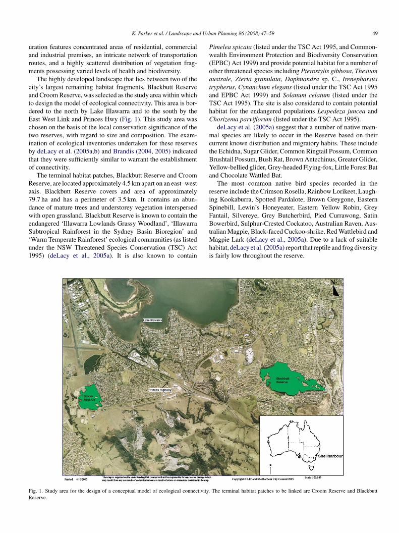
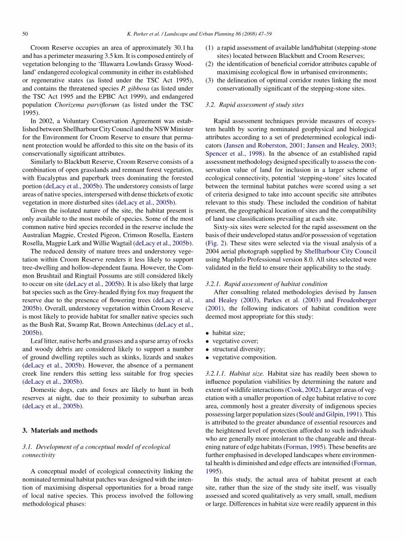
ity’s largest remaining habitat fragments, Blackbutt Reservend Croom Reserve, was selected as the study area within whicho design the model of ecological connectivity. This area is bor-ered to the north by Lake Illawarra and to the south by theast West Link and Princes Hwy (Fig. 1). This study area washosen on the basis of the local conservation significance of thewo reserves, with regard to size and composition. The exam-nation of ecological inventories undertaken for these reservesy deLacy et al. (2005a,b) and Brandis (2004, 2005) indicatedhat they were sufficiently similar to warrant the establishmentf connectivity.
The terminal habitat patches, Blackbutt Reserve and Croomeserve, are located approximately 4.5 km apart on an east–westxis. Blackbutt Reserve covers and area of approximately9.7 ha and has a perimeter of 3.5 km. It contains an abun-ance of mature trees and understorey vegetation interspersedith open grassland. Blackbutt Reserve is known to contain the
ndangered ‘Illawarra Lowlands Grassy Woodland’, ‘Illawarraubtropical Rainforest in the Sydney Basin Bioregion’ and
Warm Temperate Rainforest’ ecological communities (as listednder the NSW Threatened Species Conservation (TSC) Act995) (deLacy et al., 2005a). It is also known to containMhi
ig. 1. Study area for the design of a conceptual model of ecological connectivity.eserve.
an Planning 86 (2008) 47–59 49
imelea spicata (listed under the TSC Act 1995, and Common-ealth Environment Protection and Biodiversity Conservation
EPBC) Act 1999) and provide potential habitat for a number ofther threatened species including Pterostylis gibbosa, Thesiumustrale, Zieria granulata, Daphnandra sp. C., Irenepharsusrypherus, Cynanchum elegans (listed under the TSC Act 1995nd EPBC Act 1999) and Solanum celatum (listed under theSC Act 1995). The site is also considered to contain potentialabitat for the endangered populations Lespedeza juncea andhorizema parviflorum (listed under the TSC Act 1995).
deLacy et al. (2005a) suggest that a number of native mam-al species are likely to occur in the Reserve based on their
urrent known distribution and migratory habits. These includehe Echidna, Sugar Glider, Common Ringtail Possum, Commonrushtail Possum, Bush Rat, Brown Antechinus, Greater Glider,ellow-bellied glider, Grey-headed Flying-fox, Little Forest Batnd Chocolate Wattled Bat.
The most common native bird species recorded in theeserve include the Crimson Rosella, Rainbow Lorikeet, Laugh-ng Kookaburra, Spotted Pardalote, Brown Greygone, Easternpinebill, Lewin’s Honeyeater, Eastern Yellow Robin, Greyantail, Silvereye, Grey Butcherbird, Pied Currawong, Satinowerbird, Sulphur-Crested Cockatoo, Australian Raven, Aus-
ralian Magpie, Black-faced Cuckoo-shrike, Red Wattlebird and
agpie Lark (deLacy et al., 2005a). Due to a lack of suitableabitat, deLacy et al. (2005a) report that reptile and frog diversitys fairly low throughout the reserve.
The terminal habitat patches to be linked are Croom Reserve and Blackbutt
5 d Urb
avloatp1
lfnc
cwpav
ocAR
ttmtbr2ia2
ao(c(
r(
3
3c
ntom
(
(
(
3
tacSaseborpo
b(2uv
3
a(d
••••
3ieeapitweft
0 K. Parker et al. / Landscape an
Croom Reserve occupies an area of approximately 30.1 hand has a perimeter measuring 3.5 km. It is composed entirely ofegetation belonging to the ‘Illawarra Lowlands Grassy Wood-and’ endangered ecological community in either its establishedr regenerative states (as listed under the TSC Act 1995),nd contains the threatened species P. gibbosa (as listed underhe TSC Act 1995 and the EPBC Act 1999), and endangeredopulation Chorizema parviflorum (as listed under the TSC995).
In 2002, a Voluntary Conservation Agreement was estab-ished between Shellharbour City Council and the NSW Ministeror the Environment for Croom Reserve to ensure that perma-ent protection would be afforded to this site on the basis of itsonservationally significant attributes.
Similarly to Blackbutt Reserve, Croom Reserve consists of aombination of open grasslands and remnant forest vegetation,ith Eucalyptus and paperbark trees dominating the forestedortion (deLacy et al., 2005b). The understorey consists of largereas of native species, interspersed with dense thickets of exoticegetation in more disturbed sites (deLacy et al., 2005b).
Given the isolated nature of the site, the habitat present isnly available to the most mobile of species. Some of the mostommon native bird species recorded in the reserve include theustralian Magpie, Crested Pigeon, Crimson Rosella, Easternosella, Magpie Lark and Willie Wagtail (deLacy et al., 2005b).
The reduced density of mature trees and understorey vege-ation within Croom Reserve renders it less likely to supportree-dwelling and hollow-dependent fauna. However, the Com-
on Brushtail and Ringtail Possums are still considered likelyo occur on site (deLacy et al., 2005b). It is also likely that largeat species such as the Grey-headed flying fox may frequent theeserve due to the presence of flowering trees (deLacy et al.,005b). Overall, understorey vegetation within Croom Reserves most likely to provide habitat for smaller native species suchs the Bush Rat, Swamp Rat, Brown Antechinus (deLacy et al.,005b).
Leaf litter, native herbs and grasses and a sparse array of rocksnd woody debris are considered likely to support a numberf ground dwelling reptiles such as skinks, lizards and snakesdeLacy et al., 2005b). However, the absence of a permanentreek line renders this setting less suitable for frog speciesdeLacy et al., 2005b).
Domestic dogs, cats and foxes are likely to hunt in botheserves at night, due to their proximity to suburban areasdeLacy et al., 2005b).
. Materials and methods
.1. Development of a conceptual model of ecologicalonnectivity
A conceptual model of ecological connectivity linking theominated terminal habitat patches was designed with the inten-ion of maximising dispersal opportunities for a broad rangef local native species. This process involved the followingethodological phases:
1
sao
an Planning 86 (2008) 47–59
1) a rapid assessment of available land/habitat (stepping-stonesites) located between Blackbutt and Croom Reserves;
2) the identification of beneficial corridor attributes capable ofmaximising ecological flow in urbanised environments;
3) the delineation of optimal corridor routes linking the mostconservationally significant of the stepping-stone sites.
.2. Rapid assessment of study sites
Rapid assessment techniques provide measures of ecosys-em health by scoring nominated geophysical and biologicalttributes according to a set of predetermined ecological indi-ators (Jansen and Roberston, 2001; Jansen and Healey, 2003;pencer et al., 1998). In the absence of an established rapidssessment methodology designed specifically to assess the con-ervation value of land for inclusion in a larger scheme ofcological connectivity, potential ‘stepping-stone’ sites locatedetween the terminal habitat patches were scored using a setf criteria designed to take into account specific site attributeselevant to this study. These included the condition of habitatresent, the geographical location of sites and the compatibilityf land use classifications prevailing at each site.
Sixty-six sites were selected for the rapid assessment on theasis of their undeveloped status and/or possession of vegetationFig. 2). These sites were selected via the visual analysis of a004 aerial photograph supplied by Shellharbour City Councilsing MapInfo Professional version 8.0. All sites selected werealidated in the field to ensure their applicability to the study.
.2.1. Rapid assessment of habitat conditionAfter consulting related methodologies devised by Jansen
nd Healey (2003), Parkes et al. (2003) and Freudenberger2001), the following indicators of habitat condition wereeemed most appropriate for this study:
habitat size;vegetative cover;structural diversity;vegetative composition.
.2.1.1. Habitat size. Habitat size has readily been shown tonfluence population viabilities by determining the nature andxtent of wildlife interactions (Cook, 2002). Larger areas of veg-tation with a smaller proportion of edge habitat relative to corerea, commonly host a greater diversity of indigenous speciesossessing larger population sizes (Soule and Gilpin, 1991). Thiss attributed to the greater abundance of essential resources andhe heightened level of protection afforded to such individualsho are generally more intolerant to the changeable and threat-
ning nature of edge habitats (Forman, 1995). These benefits areurther emphasised in developed landscapes where environmen-al health is diminished and edge effects are intensified (Forman,995).
In this study, the actual area of habitat present at eachite, rather than the size of the study site itself, was visuallyssessed and scored qualitatively as very small, small, mediumr large. Differences in habitat size were readily apparent in this
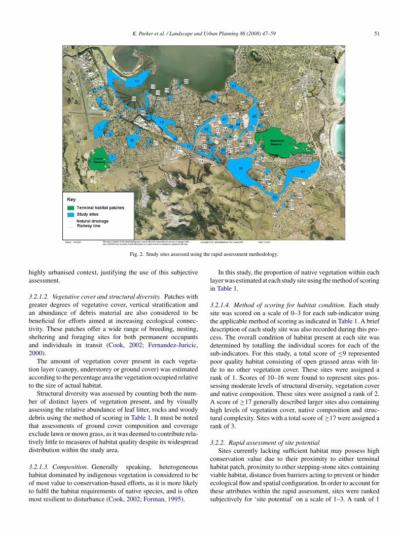
K. Parker et al. / Landscape and Urban Planning 86 (2008) 47–59 51
g the
ha
3gabtsa2
tat
badtetd
3hotm
li
3stdcdsptrsaAhtr
3
ch
Fig. 2. Study sites assessed usin
ighly urbanised context, justifying the use of this subjectivessessment.
.2.1.2. Vegetative cover and structural diversity. Patches withreater degrees of vegetative cover, vertical stratification andn abundance of debris material are also considered to beeneficial for efforts aimed at increasing ecological connec-ivity. These patches offer a wide range of breeding, nesting,heltering and foraging sites for both permanent occupantsnd individuals in transit (Cook, 2002; Fernandez-Juricic,000).
The amount of vegetation cover present in each vegeta-ion layer (canopy, understorey or ground cover) was estimatedccording to the percentage area the vegetation occupied relativeo the size of actual habitat.
Structural diversity was assessed by counting both the num-er of distinct layers of vegetation present, and by visuallyssessing the relative abundance of leaf litter, rocks and woodyebris using the method of scoring in Table 1. It must be notedhat assessments of ground cover composition and coveragexclude lawn or mown grass, as it was deemed to contribute rela-ively little to measures of habitat quality despite its widespreadistribution within the study area.
.2.1.3. Composition. Generally speaking, heterogeneous
abitat dominated by indigenous vegetation is considered to bef most value to conservation-based efforts, as it is more likelyo fulfil the habitat requirements of native species, and is oftenost resilient to disturbance (Cook, 2002; Forman, 1995).
vets
rapid assessment methodology.
In this study, the proportion of native vegetation within eachayer was estimated at each study site using the method of scoringn Table 1.
.2.1.4. Method of scoring for habitat condition. Each studyite was scored on a scale of 0–3 for each sub-indicator usinghe applicable method of scoring as indicated in Table 1. A briefescription of each study site was also recorded during this pro-ess. The overall condition of habitat present at each site wasetermined by totalling the individual scores for each of theub-indicators. For this study, a total score of ≤9 representedoor quality habitat consisting of open grassed areas with lit-le to no other vegetation cover. These sites were assigned aank of 1. Scores of 10–16 were found to represent sites pos-essing moderate levels of structural diversity, vegetation covernd native composition. These sites were assigned a rank of 2.
score of ≥17 generally described larger sites also containingigh levels of vegetation cover, native composition and struc-ural complexity. Sites with a total score of ≥17 were assigned aank of 3.
.2.2. Rapid assessment of site potentialSites currently lacking sufficient habitat may possess high
onservation value due to their proximity to either terminalabitat patch, proximity to other stepping-stone sites containing
iable habitat, distance from barriers acting to prevent or hindercological flow and spatial configuration. In order to account forhese attributes within the rapid assessment, sites were rankedubjectively for ‘site potential’ on a scale of 1–3. A rank of 1
52 K. Parker et al. / Landscape and Urban Planning 86 (2008) 47–59
Table 1Indicators and methods of scoring used to rapidly assess the condition of vegetation in study sites
Category Indicator Sub-indicator Score Method of scoring
Habitat condition Size Relative habitat size 0–3 0 = very small; 1 = small; 2 = medium; 3 = large
Cover Canopy cover 0–3 0 = absent; 1 = 1–29%; 2 = 30–59%; 3 ≥ 60% coverUnderstorey cover 0–3 0 = absent; 1 = 1–29%; 2 = 30–59%; 3 = ≥60% coverGround covera 0–3 0 = absent; 1 = 1–29%; 2 = 30–59%; 3 = ≥60% cover
Structural diversity Number of layers 0–3 0 = no layers; 1 = layer; 2 = 2 layers; 3 = ground cover,understorey and canopy layers present
Leaf litter 0–3 0 = none; 1 = 1–29%; 2 = 30–59%; 3 = ≥60% ground coverLogs and rocks 0–3 0 = none; 1 = small quantities; 2 = abundant but some
removed; 3 = relatively intact
Composition Natives in canopy 0–3 0 = ≤20%; 1 = 21–50%; 2 = 51–80%; 3 = ≥81%Natives in understorey 0–3 0 = ≤20%; 1 = 21–50%; 2 = 51–80%; 3 = ≥81%
ra
A denbe
wartto
3
hpposPcc
ast
3
wsAgw
fc1
3
tcpsqfbd(B
3
eclaa
TM
R
1
2
3
C
Natives in ground cove
dapted from sources: Jansen and Healey (2003), Parkes et al. (2003) and Freua Ground cover excludes lawn.
as awarded to sites deemed to be of least worth to efforts aimedt establishing ecological connectivity across the study area. Aank of 2 was awarded to sites possessing moderate conserva-ion value, whereas sites achieving a rank of 3 were consideredo have greatest functional value according to the previouslyutlined attributes.
.2.3. Land use compatibilityThe future success of conservation efforts within the Shell-
arbour LGA will largely depend on the nature of land useermitted across the study area. For this reason, land use com-atibility was considered to comprise an important componentf the rapid assessment. Land use zones governing each of theites were obtained from the Shellharbour Local Environmentlan (2000). Table 2 displays the ranks awarded to land uselassifications present within the study area on the basis of theirompatibility to biodiversity conservation-based efforts.
As some study sites were undergoing development, orppeared to be earmarked for development, the area of eachite available for inclusion in the model was recorded to ensurehe final configuration of ecological connectivity was realistic.
.2.4. Final site classificationThe final rankings for each of the rapid assessment categories
ere totalled for each site to reveal the most conservationally
ignificant sites. Final scores were grouped into three classes:, B and C. Sites belonging to class A were deemed to be ofreatest value with scores ranging from 7 to 9. Class B sitesere considered to be of moderate value with scores rangingaaft
able 2ethod of ranking used to assess the compatibility of land use classifications prevail
ank Method of ranking
Land uses classified as: 1(c) Rural
Land uses classified as: 5(a) Speci
Land uses classified as: 4(a3) Airp7(d) Environmental Protection (Sc
ategory: land use; Indicator: land use classification.
0–3 0 = ≤20%; 1 = 21–50%; 2 = 51–80%; 3 = ≥81%
rger (2001).
rom 4 to 6. Of least value to the proposed model of ecologicalonnectivity were class C sites consisting of scores ranging fromto 3.
.3. Corridor delineation
Corridor scenarios were proposed between the terminal habi-at patches to link the available areas of land identified withinlass A sites. These scenarios were identified from the aerialhotograph using MapInfo Professional version 8.0, before sub-equent validation in the field. Corridor scenarios were assignedualitatively by taking into account a number of corridor designeatures deemed capable of maximising ecological flow for aroad range of indigenous species. These features include corri-or structure, composition, continuity, shape, length and widthForman, 1995; Cook, 2002; Soule and Gilpin, 1991; Fleury andrown, 1997).
.3.1. Corridor structure and compositionThe structure and composition of habitat corridors is consid-
red to exert a major influence on the functionality of ecologicalonnectivity configurations. These characteristics are particu-arly significant as they largely control the diversity of speciesnd number of individuals that may be accommodated withincorridor in terms of suitability to mode of dispersal, resource
vailability, and provision of escape cover (Cook, 2002; Fleurynd Brown, 1997). Lindenmayer et al. (1993) present evidenceor the influence of structure on corridor utility, observing thathe Greater Glider and Mountain Brushtail Possum were rarely
ing in the study area with biodiversity conservation-based efforts
C Zone; 2(e) Mixed Use Residential E Zone; 4(a) Light Industrial Zone
al Uses Zone; 6(a) Public Open Space; 6(b) Private Open Space
ort Light Industrial Zone; 7(a) Environmental Protection (Wetlands) Zone;enic) Zone
d Urb
daemtb
3
irBmgciF
aeswwagwdted(
3
sve1aadaltdhafc
3
ocsrt
i1wstalmts
3
ebiOrg1cpi1hetoamio
wehimp
4
4
tiab
4
K. Parker et al. / Landscape an
etected in corridors offering few nest sites. Similarly, Catlingnd Burt (1995) suggest that a well-developed understorey isssential to facilitate passage of small ground dwelling mam-als in south-eastern New South Wales, Australia as it provides
he necessary cover to reduce the risks associated with movementetween preferred habitat patches.
.3.2. Corridor continuityAchieving corridor continuity has been presented as an
mportant prerequisite to facilitating ecological flow betweenemnant populations (Bennett, 1990; Cook, 2002; Fleury andrown, 1997). This is because impediments to the dispersal origration of species such as barriers (physical obstructions) or
aps (interruptions to continuity) commonly increase the diffi-ulty and risk associated with migration and dispersal by forcingndividuals to enter inhospitable environments (Cook, 2002;leury and Brown, 1997).
The clearing of vegetation for housing and the constructionnd use of roads and buildings are considered to be the great-st obstructions to individual movements. Landscape featuresuch watercourses may also act as natural barriers for speciesith incompatible dispersal modes (Forman, 1995). It is alsoidely agreed that the dispersal ranges and behavioural char-
cteristics of different species, the extent of contrast betweenap and corridor habitat, and the size of imposed obstructionsill determine the extent to which movement is restricted forifferent species (Fleury and Brown, 1997). Ultimately, specieshat have incompatible modes of dispersal, are not adapted todge environments, possess wide home ranges and exist at lowensities are considered to be the most vulnerable to edge affectsFleury and Brown, 1997; Bennett, 2003).
.3.3. Corridor shapeInitial investigations concerning the influence of corridor
hape on the ease of passage of individuals have indicated thatariations in the two-dimensional form of corridors may influ-nce the probability of successful passage (Soule and Gilpin,991; Fleury and Brown, 1997). Soule and Gilpin (1991) usingsimulation study suggest that corridor forms deviating fromsimple rectangular configuration often pose difficulties for
ispersing individuals, with significant increases in resistancessociated with bends and width deviations in these landscapeinkages. The success of rectangular corridors was attributed tohe minimal amount of time spent in the outer edge of the corri-or where conditions are less favourable and mortality rates areighest, and the consistent direction of ecological flow (Soulend Gilpin, 1991). Whilst these results are intuitively appealing,urther investigation is required to validate the significance oforridor configuration in the field.
.3.4. Corridor lengthThe limited amount of literature investigating the influence
f corridor length on the effectiveness of connective landscape
onfigurations is consistent with observations obtained in othertudies of landscape variables, in that the length of corridorsequired to maximise efficiency appears to be closely related tohe dispersal capacity, speed of passage and life expectancy ofbsfia
an Planning 86 (2008) 47–59 53
ndividual species (Soule and Gilpin, 1991; Fleury and Brown,997). In general, shorter corridors are more beneficial to speciesith higher mortality rates as well as those with slower dispersal
peeds and ranges, as they minimise the probability of preda-ion and reduce the energy costs associated with dispersal (Soulend Gilpin, 1991). Because urban environments rarely supportarger mammals that would require longer corridors to comple-
ent their migratory behaviour, Soule and Gilpin (1991) arguehat urban corridors should connect key areas of habitat via thehortest and most direct route.
.3.5. Corridor widthWhilst it is generally agreed that corridors must be wide
nough to provide shelter, resources and facilitate passageetween habitat patches (Fleury and Brown, 1997), the spec-fication of a desired corridor width remains an impractical task.nce again this is due to the widely varying environmental
equirements of the many species that may potentially use aiven corridor (Loney and Hobbs, 1991; Fleury and Brown,997). However, many authors suggest that despite the asso-iated advantages of streamlining migration between habitatatches, narrow corridors may not be as beneficial to dispersingndividuals as wider corridors (Soule and Gilpin, 1991; Forman,995). This may be attributed to that fact that narrower corridorsave a high ratio of edge to interior habitat, resulting in height-ned levels of mortality for some species not as well adaptedo the varied edge conditions and the associated increased riskf predation (Soule and Gilpin, 1991; Forman, 1995). It haslso been noted by Lindenmayer (1994) that wider corridorsay capture a wider variety of habitat types and thus possess an
ncreased capacity to support the movement of a greater diversityf species with differing requirements.
Whilst further research is required to determine exactly howide is in fact ‘wide enough’, it is suggested here that in urban
nvironments where the availability of space and pre-existingabitat is limited, corridor design efforts should seek to max-mise the width of corridors in the area available so as to
inimise edge effects and encourage passage between habitatatches.
. Results
.1. Rapid assessment of study sites
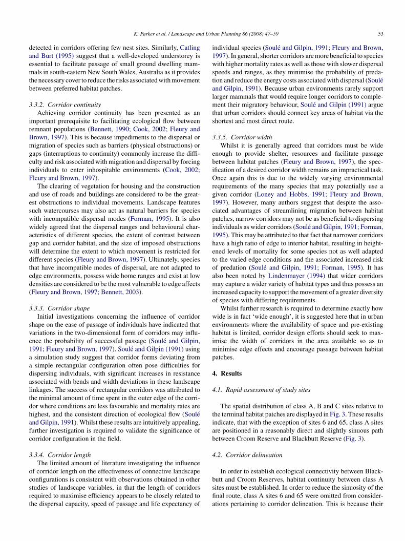
The spatial distribution of class A, B and C sites relative tohe terminal habitat patches are displayed in Fig. 3. These resultsndicate, that with the exception of sites 6 and 65, class A sitesre positioned in a reasonably direct and slightly sinuous pathetween Croom Reserve and Blackbutt Reserve (Fig. 3).
.2. Corridor delineation
In order to establish ecological connectivity between Black-
utt and Croom Reserves, habitat continuity between class Aites must be established. In order to reduce the sinuosity of thenal route, class A sites 6 and 65 were omitted from consider-tions pertaining to corridor delineation. This is because their
54 K. Parker et al. / Landscape and Urban Planning 86 (2008) 47–59
s dete
pdod
•••
oiIaa
taWtaiThmaet
o(ic2sdeebb
5
5c
mnaro
Fig. 3. Study site classifications a
osition in the landscape deviated significantly from the generalirection of ecological flow created by the spatial configurationf the rest of class A sites. Ultimately, corridor scenarios wereevised for three linkage opportunities between:
Croom Reserve and site 2 (Link 1) (Fig. 4);sites 2 and 24 (Link 2) (Fig. 5);sites 24 and Blackbutt Reserve (Link 3) (Fig. 6).
Corridor widths were assigned by maximising the amountf available space although attention was also paid to maintain-ng relatively consistent corridor widths across the study area.t must be noted that all corridor scenarios assumed movementcross road barriers was feasible, as they were largely unavoid-ble given the highly developed nature of the study area.
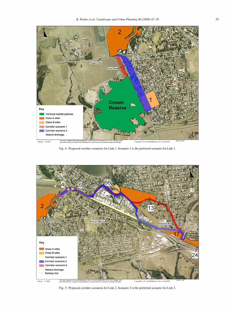
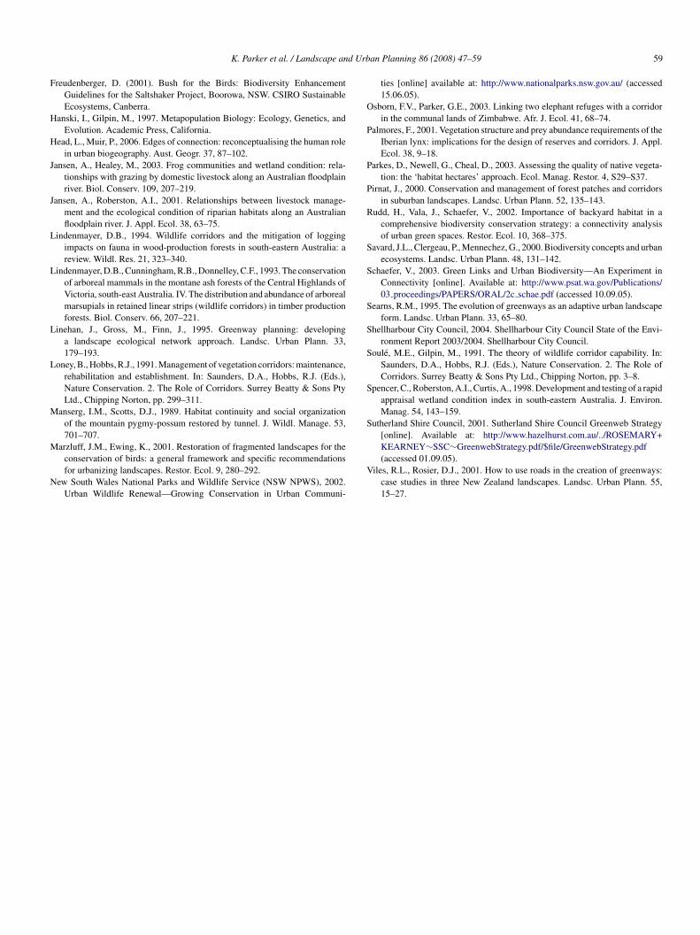
Table 3 indicates that corridor scenario 1 for Link 1 possessedhe greatest potential to enhance ecological flow across the studyrea based on the ecological and spatial attributes examined.
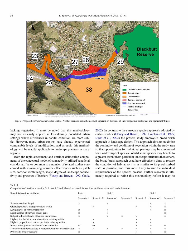
hilst it would seem that the most direct route for Link 2, inhis case scenario 1, would be particularly beneficial to individu-ls making passage between the terminal habitat patches, onsitenvestigations revealed scenario 3 as the preferred path (Fig. 5).his is due to the fact that this scenario possessed reasonablyigh levels of vegetation cover and structural diversity along the
ajority of its length relative to the other scenarios. There waslso potential along this route to expand the current area of veg-tation without compromising visibility of the train station fromhe road, a potentially significant community safety concern.
avta
rmined by the rapid assessment.
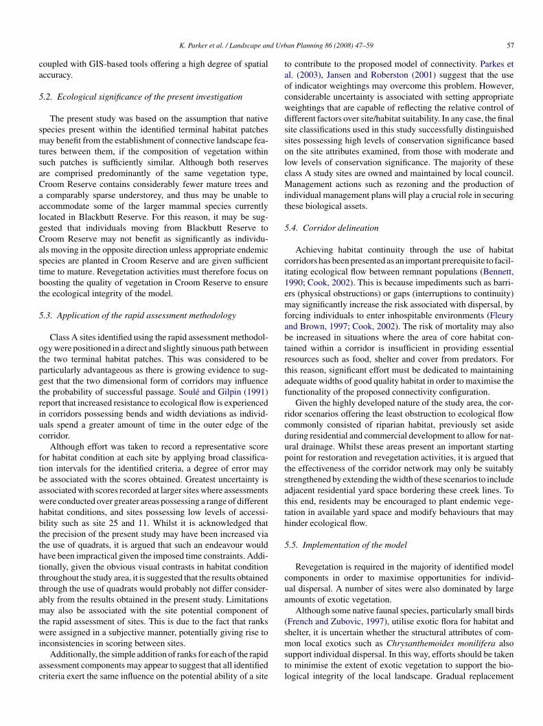
Neither corridor scenario for Link 3 could be deemed superiorn the basis of their respective ecological and spatial attributesFig. 6). Both routes are of similar length and width and arenterrupted by a similar number of roads. Because, site 38 isurrently undergoing subdivision it is envisaged that scenariowill eventually feature a comparable amount of vegetation to
cenario 1 and will also be subject to a similar degree of humanisturbance. As it is uncertain whether it is preferential to utilizexisting poorer quality habitat or start from scratch by plantingndemic species on available land, either scenario 1 or 2 maye used for the purpose of establishing ecological connectivityetween the terminal habitat patches.
. Discussion
.1. Development of the conceptual model of ecologicalonnectivity
A rapid assessment methodology was used to identify theost conservationally significant areas for inclusion in a con-
ectivity strategy to link Blackbutt and Croom Reserves. Thispproach was selected because of its ability to provide rapid,epeatable results, without demanding an in-depth knowledgef the floral species present (Parkes et al., 2003). The use of
rapid assessment methodology was also favoured as it pro-ided a means within which to evaluate sites on the basis ofheir ability to support a wide range of species, not only inreas containing significant habitat, but also in sites currently
K. Parker et al. / Landscape and Urban Planning 86 (2008) 47–59 55
Fig. 4. Proposed corridor scenarios for Link 1. Scenario 1 is the preferred scenario for Link 1.
Fig. 5. Proposed corridor scenarios for Link 2. Scenario 3 is the preferred scenario for Link 2.
56 K. Parker et al. / Landscape and Urban Planning 86 (2008) 47–59
eeme
lmstcor
nccst
2eRatsfat
TC
B
SGLLSHHISP
Fig. 6. Proposed corridor scenarios for Link 3. Neither scenario could be d
acking vegetation. It must be noted that this methodologyay not as easily applied in less densely populated urban
ettings where differences in habitat condition are more sub-le. However, many urban centres have already experiencedomparable levels of modification, and as such, this method-logy will be readily applicable to landscape planners in manyegions.
Both the rapid assessment and corridor delineation compo-ents of the conceptual model of connectivity utilised beneficial
orridor attributes common to a number of related studies con-erned with maximising corridor effectiveness such as patchize, corridor width, length, shape, degree of landscape connec-ivity and presence of barriers (Fleury and Brown, 1997; Cook,tsrm
able 3omparison of corridor scenarios for Links 1, 2 and 3 based on beneficial corridor at
eneficial corridor attributes Link 1
Scenario 1 Sce
hortest corridor length ×reatest potential average corridor width ×owest level of corridor sinuosity ×east number of barriers and/or gaps ×ubject to lowest levels of human disturbance ×ighest level of structural diversity in existing habitat ×ighest proportion of native species in existing habitat ×
ncorporates greatest amount of riparian habitat na naituated on land possessing a compatible land use classification × ×referred corridor scenario ×
d superior on the basis of their respective ecological and spatial attributes.
002). In contrast to the surrogate species approach adopted byarlier studies (Fleury and Brown, 1997; Linehan et al., 1995;udd et al., 2002) the present study employs a broad-brushpproach to landscape design. This approach aims to maximisehe continuity and condition of vegetation within the study areao that opportunities for individual passage may be maximisedor a wide range of species. Whilst some species may benefit togreater extent from particular landscape attributes than others,
he broad-brush approach used here effectively aims to restore
he condition of habitat so it is as similar to its pre-disturbedtate as possible, and thus most likely to suit the individualequirements of the species present. Further research is ulti-ately required to refine this methodology before it may betributes advocated in the literature
Link 1 Link 1
nario 2 Scenario 1 Scenario 2 Scenario 3 Scenario 1 Scenario 2
× × ×× × ×
× × ×× ×× × × ×
× ×× ×× na na
× × × × ×× × ×
d Urb
ca
5
smtsaCaalgCastbt
5
otpgtriuc
ftbawhbtthtttamtwi
ac
taocwdssolcMit
5
ci1emfabtrtaf
rcduptsatth
5
cua
(s
K. Parker et al. / Landscape an
oupled with GIS-based tools offering a high degree of spatialccuracy.
.2. Ecological significance of the present investigation
The present study was based on the assumption that nativepecies present within the identified terminal habitat patchesay benefit from the establishment of connective landscape fea-
ures between them, if the composition of vegetation withinuch patches is sufficiently similar. Although both reservesre comprised predominantly of the same vegetation type,room Reserve contains considerably fewer mature trees andcomparably sparse understorey, and thus may be unable to
ccommodate some of the larger mammal species currentlyocated in Blackbutt Reserve. For this reason, it may be sug-ested that individuals moving from Blackbutt Reserve toroom Reserve may not benefit as significantly as individu-ls moving in the opposite direction unless appropriate endemicpecies are planted in Croom Reserve and are given sufficientime to mature. Revegetation activities must therefore focus onoosting the quality of vegetation in Croom Reserve to ensurehe ecological integrity of the model.
.3. Application of the rapid assessment methodology
Class A sites identified using the rapid assessment methodol-gy were positioned in a direct and slightly sinuous path betweenhe two terminal habitat patches. This was considered to bearticularly advantageous as there is growing evidence to sug-est that the two dimensional form of corridors may influencehe probability of successful passage. Soule and Gilpin (1991)eport that increased resistance to ecological flow is experiencedn corridors possessing bends and width deviations as individ-als spend a greater amount of time in the outer edge of theorridor.
Although effort was taken to record a representative scoreor habitat condition at each site by applying broad classifica-ion intervals for the identified criteria, a degree of error maye associated with the scores obtained. Greatest uncertainty isssociated with scores recorded at larger sites where assessmentsere conducted over greater areas possessing a range of differentabitat conditions, and sites possessing low levels of accessi-ility such as site 25 and 11. Whilst it is acknowledged thathe precision of the present study may have been increased viahe use of quadrats, it is argued that such an endeavour wouldave been impractical given the imposed time constraints. Addi-ionally, given the obvious visual contrasts in habitat conditionhroughout the study area, it is suggested that the results obtainedhrough the use of quadrats would probably not differ consider-bly from the results obtained in the present study. Limitationsay also be associated with the site potential component of
he rapid assessment of sites. This is due to the fact that ranksere assigned in a subjective manner, potentially giving rise to
nconsistencies in scoring between sites.Additionally, the simple addition of ranks for each of the rapid
ssessment components may appear to suggest that all identifiedriteria exert the same influence on the potential ability of a site
mstl
an Planning 86 (2008) 47–59 57
o contribute to the proposed model of connectivity. Parkes etl. (2003), Jansen and Roberston (2001) suggest that the usef indicator weightings may overcome this problem. However,onsiderable uncertainty is associated with setting appropriateeightings that are capable of reflecting the relative control ofifferent factors over site/habitat suitability. In any case, the finalite classifications used in this study successfully distinguishedites possessing high levels of conservation significance basedn the site attributes examined, from those with moderate andow levels of conservation significance. The majority of theselass A study sites are owned and maintained by local council.anagement actions such as rezoning and the production of
ndividual management plans will play a crucial role in securinghese biological assets.
.4. Corridor delineation
Achieving habitat continuity through the use of habitatorridors has been presented as an important prerequisite to facil-tating ecological flow between remnant populations (Bennett,990; Cook, 2002). This is because impediments such as barri-rs (physical obstructions) or gaps (interruptions to continuity)ay significantly increase the risk associated with dispersal, by
orcing individuals to enter inhospitable environments (Fleurynd Brown, 1997; Cook, 2002). The risk of mortality may alsoe increased in situations where the area of core habitat con-ained within a corridor is insufficient in providing essentialesources such as food, shelter and cover from predators. Forhis reason, significant effort must be dedicated to maintainingdequate widths of good quality habitat in order to maximise theunctionality of the proposed connectivity configuration.
Given the highly developed nature of the study area, the cor-idor scenarios offering the least obstruction to ecological flowommonly consisted of riparian habitat, previously set asideuring residential and commercial development to allow for nat-ral drainage. Whilst these areas present an important startingoint for restoration and revegetation activities, it is argued thathe effectiveness of the corridor network may only be suitablytrengthened by extending the width of these scenarios to includedjacent residential yard space bordering these creek lines. Tohis end, residents may be encouraged to plant endemic vege-ation in available yard space and modify behaviours that mayinder ecological flow.
.5. Implementation of the model
Revegetation is required in the majority of identified modelomponents in order to maximise opportunities for individ-al dispersal. A number of sites were also dominated by largemounts of exotic vegetation.
Although some native faunal species, particularly small birdsFrench and Zubovic, 1997), utilise exotic flora for habitat andhelter, it is uncertain whether the structural attributes of com-
on local exotics such as Chrysanthemoides monilifera alsoupport individual dispersal. In this way, efforts should be takeno minimise the extent of exotic vegetation to support the bio-ogical integrity of the local landscape. Gradual replacement

5 d Urb
od
5
vlutwSmbgimrafialp
ogCtic
tomfmifa
6
tseebb
hcotowb
igeaHefuoaabil
A
f
R
B
B
B
B
B
B
B
C
C
C
d
d
D
F
F
8 K. Parker et al. / Landscape an
f exotic species with local native alternatives will minimiseisturbance to individuals currently using these sites.
.6. Management issues
Engaging identified residents and landholders in conser-ation-based activities may present a significant challenge toocal government, given statewide knowledge and support ofrban biodiversity issues is generally low. A survey conducted byhe NSW National Parks and Wildlife Service (NPWS) (2002)hich examined the attitudes of urban residents in the greaterydney area to the conservation of wildlife in urban environ-ents, indicated that the majority of respondents perceived
iodiversity to be a ‘distant issue’ of primary significance toovernment authorities and environmental experts. The major-ty of respondents also indicated that they felt it was necessary to
ake the distinction between urban areas and the natural envi-onment, with existing areas of habitat in urban areas thought ofs ‘left over bits and pieces’, rather than components of a modi-ed and disturbed ecosystem (NSW NPWS, 2002). However, inmore in-depth study, Head and Muir (2006) have shown high
evels of engagement among residents who share a border withublic bushland.
Attempts to modify attitudes that may prevent the alignmentf community behaviours with biodiversity conservation-basedoals have been successful in the Greater Vancouver Area,anada. Here community workshops, contests, murals, adver-
isements and educational materials have significantly raisedndividual levels of stewardship for the environment and appre-iation for urban biodiversity (Schaefer, 2003).
Finally, it is also important to note that a number of addi-ional management issues such as maintaining adequate levelsf security, minimising fire hazard, assigning maintenance andonitoring responsibilities as well as identifying cost bearers
or activities undertaken on private and government owned land,ay also influence the success of efforts to implement connectiv-
ty strategies in urban environments. The consideration requiredor each of these issues will vary depending on local conditionsnd priorities.
. Conclusions
The rapid assessment methodology developed specifically forhis study was found to be particularly useful in identifying studyites of conservation significance for inclusion in the model ofcological connectivity. Such sites were found to be larger areasither presently containing good quality habitat or capable ofeing sufficiently revegetated, located in a relatively direct pathetween Blackbutt and Croom Reserves.
The delineation of corridor linkages revealed that riparianabitat has a particularly significant role to play in achievingonnectivity between the terminal habitat patches. Such areas,riginally set aside during subdivision, were commonly found
o possess superior levels of habitat quality and continuity. Inrder to maximise the efficacy of the proposed ecological net-ork, it is recommended that the width of these riparian corridorse extended through the use of adjacent nature strips and res-F
F
an Planning 86 (2008) 47–59
dential yard space. However, enlisting the participation of theeneral community presents a significant challenge to local gov-rnment. Strategies seeking to encourage participation shouldim to enhance levels of appreciation for native biodiversity.ighlighting the need for united action may also inspire height-
ned levels of stewardship for the local environment. Whilsturther study is required to refine present understandings ofrban landscape attributes on species movements, the methodol-gy outlined in the present study may be used as a broad habitatssessment tool where a lack of time and resources preventsmore exhaustive investigation. This will enable planners to
ridge the gap in scientific knowledge that has previously lim-ted the incorporation of biodiversity-based objectives in urbanand use decisions.
cknowledgements
The authors would like to thank Shellharbour City Councilor supplying the aerial photograph used in this study.
eferences
eier, P., 1995. Dispersal of juvenile cougars in fragmented habitat. J. Wildl.Manag. 59, 228–237.
ennett, A.F., 1990. Habitat Corridors: Their Role in Wildlife Management andConservation. Department of Conservation and the Environment, Victoria.
ennett, A.F., 2003. Linkages in the Landscape: The Role of Corridors andConnectivity in Wildlife Conservation. International Union for Conservationof Nature and Natural Resources. Gland, Switzerland, Cambridge.
erggren, A., Birath, B., Kindvall, O., 2002. Effect of corridors and habitat edgeson dispersal behaviour, movement rates and movement angles in Roesel’sBush-Cricket (Metrioptera roeseli). Conserv. Biol. 16, 1562–1569.
randis, C., 2004. Status of the Birds of Blackbutt Reserve, Shellharbour,NSW. Unpublished report held by Shellharbour City Council. Illawarra BirdObservers Club, Inc.
randis, C., 2005. Status of the Birds of Croom Sporting Complex and LightRailway Reserves, Albion Park Rail, Shellharbour, NSW. Unpublishedreport held by Shellharbour City Council. Illawarra Bird Observers Club,Inc.
ryant, M.M., 2006. Urban landscape conservation and the role of ecologicalgreenways at local and metropolitan scales. Landsc. Urban. Plann. 76, 23–44.
atling, P.C., Burt, R.J., 1995. Studies of the ground-dwelling mammals ofeucalypt forests in south-eastern New South Wales: the effect of habitatvariables on distribution and abundance. Wildl. Res. 22, 271–288.
ook, E.A., 2002. Landscape structure indices for assessing urban ecologicalnetworks. Landsc. Urban Plann. 58, 269–280.
ornelis, J., Hermy, M., 2004. Biodiversity relationships in urban and suburbanparks in Flanders. Landsc. Urban Plann. 69, 385–401.
eLacy, C., Chamberlain, S., Welsh, M., 2005a. Blackbutt Reserve, BlackbuttShellharbour: Bushfire Management Plan. Bangalay Botanic Surveys.
eLacy, C., Chamberlain, S., Welsh, M., 2005b. Croom Regional Sports Com-plex and Reserve, Croom: Bushfire Management Plan. Bangalay BotanicSurveys.
iamond, J.M., 1975. The island dilemma: lessons of modern biogeographicstudies for the design of natural reserves. Biol. Conserv. 7, 129–146.
ernandez-Juricic, E., 2000. Avifaunal use of wooded streets in an urban land-scape. Conserv. Biol. 14, 513–521.
leury, A.M., Brown, R.D., 1997. A framework for the design of wildlife conser-vation corridors with specific application to southwestern Ontario. Landsc.
Urban Plann. 37, 163–186.orman, R.T.T., 1995. Land Mosaics: The Ecology of Landscapes and Regions.Cambridge University Press, Cambridge.
rench, K., Zubovic, A., 1997. Effects of the weed Chrysanthemoides moniliferaBitou Bush on bird communities. Wildl. Res. 24, 727–735.
d Urb
F
H
H
J
J
L
L
L
L
M
M
N
O
P
P
P
R
S
S
S
S
S
S
S
K. Parker et al. / Landscape an
reudenberger, D. (2001). Bush for the Birds: Biodiversity EnhancementGuidelines for the Saltshaker Project, Boorowa, NSW. CSIRO SustainableEcosystems, Canberra.
anski, I., Gilpin, M., 1997. Metapopulation Biology: Ecology, Genetics, andEvolution. Academic Press, California.
ead, L., Muir, P., 2006. Edges of connection: reconceptualising the human rolein urban biogeography. Aust. Geogr. 37, 87–102.
ansen, A., Healey, M., 2003. Frog communities and wetland condition: rela-tionships with grazing by domestic livestock along an Australian floodplainriver. Biol. Conserv. 109, 207–219.
ansen, A., Roberston, A.I., 2001. Relationships between livestock manage-ment and the ecological condition of riparian habitats along an Australianfloodplain river. J. Appl. Ecol. 38, 63–75.
indenmayer, D.B., 1994. Wildlife corridors and the mitigation of loggingimpacts on fauna in wood-production forests in south-eastern Australia: areview. Wildl. Res. 21, 323–340.
indenmayer, D.B., Cunningham, R.B., Donnelley, C.F., 1993. The conservationof arboreal mammals in the montane ash forests of the Central Highlands ofVictoria, south-east Australia. IV. The distribution and abundance of arborealmarsupials in retained linear strips (wildlife corridors) in timber productionforests. Biol. Conserv. 66, 207–221.
inehan, J., Gross, M., Finn, J., 1995. Greenway planning: developinga landscape ecological network approach. Landsc. Urban Plann. 33,179–193.
oney, B., Hobbs, R.J., 1991. Management of vegetation corridors: maintenance,rehabilitation and establishment. In: Saunders, D.A., Hobbs, R.J. (Eds.),Nature Conservation. 2. The Role of Corridors. Surrey Beatty & Sons PtyLtd., Chipping Norton, pp. 299–311.
anserg, I.M., Scotts, D.J., 1989. Habitat continuity and social organizationof the mountain pygmy-possum restored by tunnel. J. Wildl. Manage. 53,701–707.
arzluff, J.M., Ewing, K., 2001. Restoration of fragmented landscapes for theconservation of birds: a general framework and specific recommendationsfor urbanizing landscapes. Restor. Ecol. 9, 280–292.
ew South Wales National Parks and Wildlife Service (NSW NPWS), 2002.Urban Wildlife Renewal—Growing Conservation in Urban Communi-
V
an Planning 86 (2008) 47–59 59
ties [online] available at: http://www.nationalparks.nsw.gov.au/ (accessed15.06.05).
sborn, F.V., Parker, G.E., 2003. Linking two elephant refuges with a corridorin the communal lands of Zimbabwe. Afr. J. Ecol. 41, 68–74.
almores, F., 2001. Vegetation structure and prey abundance requirements of theIberian lynx: implications for the design of reserves and corridors. J. Appl.Ecol. 38, 9–18.
arkes, D., Newell, G., Cheal, D., 2003. Assessing the quality of native vegeta-tion: the ‘habitat hectares’ approach. Ecol. Manag. Restor. 4, S29–S37.
irnat, J., 2000. Conservation and management of forest patches and corridorsin suburban landscapes. Landsc. Urban Plann. 52, 135–143.
udd, H., Vala, J., Schaefer, V., 2002. Importance of backyard habitat in acomprehensive biodiversity conservation strategy: a connectivity analysisof urban green spaces. Restor. Ecol. 10, 368–375.
avard, J.L., Clergeau, P., Mennechez, G., 2000. Biodiversity concepts and urbanecosystems. Landsc. Urban Plann. 48, 131–142.
chaefer, V., 2003. Green Links and Urban Biodiversity—An Experiment inConnectivity [online]. Available at: http://www.psat.wa.gov/Publications/03 proceedings/PAPERS/ORAL/2c schae.pdf (accessed 10.09.05).
earns, R.M., 1995. The evolution of greenways as an adaptive urban landscapeform. Landsc. Urban Plann. 33, 65–80.
hellharbour City Council, 2004. Shellharbour City Council State of the Envi-ronment Report 2003/2004. Shellharbour City Council.
oule, M.E., Gilpin, M., 1991. The theory of wildlife corridor capability. In:Saunders, D.A., Hobbs, R.J. (Eds.), Nature Conservation. 2. The Role ofCorridors. Surrey Beatty & Sons Pty Ltd., Chipping Norton, pp. 3–8.
pencer, C., Roberston, A.I., Curtis, A., 1998. Development and testing of a rapidappraisal wetland condition index in south-eastern Australia. J. Environ.Manag. 54, 143–159.
utherland Shire Council, 2001. Sutherland Shire Council Greenweb Strategy[online]. Available at: http://www.hazelhurst.com.au/../ROSEMARY+
KEARNEY∼SSC∼GreenwebStrategy.pdf/$file/GreenwebStrategy.pdf(accessed 01.09.05).iles, R.L., Rosier, D.J., 2001. How to use roads in the creation of greenways:case studies in three New Zealand landscapes. Landsc. Urban Plann. 55,15–27.