Embed Size (px)
Citation preview

A comparison of kinship family survival in York and
Swaledale in the nineteenth century
Thesis submitted for the degree of
Doctor of Philosophy
at the University of Leicester
by
Philip Anthony Batman
MA(Leic), MD(Cantab), FRCPath
Centre for English Local History
University of Leicester
April 2020

ii
Abstract
A comparison of kinship family survival in York and Swaledale in
the nineteenth century
Philip Anthony Batman
Kinship networks were fundamental in importance to family life in both the urban and rural
settings in nineteenth-century England. They could also be crucial in facilitating the process
of migration. This thesis explores the ways in which kinship families over the nineteenth
century responded to the stimulus to migrate. Kinship families are defined as several
households in a community headed by people with the same surname who were related by
lineage or marriage. Groups of people are quantified by a simple numerical index (surname
index), then tracked across historical time using decennial census data, baptismal parish
registers and memorial inscriptions. The surname index is an innovative powerful
demographic tool for analysing, measuring and comparing sectors of the population within
and between different communities and across time. People induced to migrate could follow
the path of others who had gone before. The index in this study has been used to apply a
measure to such chain migration of people with the same surname moving into York and out
of Swaledale in the Northern Pennines.
Migrant families came into York from mid-century to work on the railways or in flight from
Ireland at the time of the Irish potato famine, and out of rural Swaledale during collapse of
the lead-mining industry. Marked rural-urban differences are found in these migrations.
Railway kinship families formed a new community which grew for the remainder of the
century. Irish families arrived en masse and concentrated in an impoverished slum district of
York. Relatives often chose to live in close proximity. Holding of land was key to survival
for Swaledale families. Predominantly large kinship families migrated out of Swaledale to
other mining areas including North America.
The thesis furthers the debate about migration and kinship by showing that the impetus to
migrate could affect kinship families in different ways from non-kinship families, and that
complementary quantifiable chain migrations of related kin gathered pace into an urban and
out of a rural setting during the nineteenth century.

iii
For my family,
given and chosen

iv
Acknowledgements
This thesis has been many years in the writing and I have incurred many debts along the way.
The work has been a great personal pleasure, and in dark times it has been my refuge and
salvation. There are a few people to whom I should like to give my special thanks. My three
supervisors in Leicester have been magnificent, each in their own individual way: Prof Kevin
Schürer for giving my work structure and intellectual rigour; Prof Simon Gunn for making
me realise that numerical ‘indices’ are not an end in themselves; and Prof Keith Snell for
inspirational ideas. There are also some people I should like to thank from times beyond
Leicester who have been cornerstones of my life: Prof George Griffin, a physician and
mentor who introduced me to the joy of finding out new things; and James Turnbull (a
coroner), Denis Parker (a colleague), and Monica Barry and Bonnie Kelly (friends) who
helped me believe in myself when I needed to. Finally my own family to whom this work is
dedicated. The focus of my interest is family life, and I could not function without my own:
my children Tom and Emma, for never making the mistake of taking me (too) seriously; and
my late beloved wife Miche, for giving me all the space I ever needed and taking delight in
any path we chose to take, and in our family, which she left far too early.
I should also like to acknowledge City of York Council/Explore Libraries and Archives, for
permission to reproduce: Figure 26 Terraced railway housing including St Paul’s Terrace and
Railway Terrace in the 1950s (image number 6259); Figure 27 Back yards of railway housing
in the Holgate area of York in the 1950s (image number 6450); Figure 28 Entrance to Mount
Terrace from Holgate Road in 1922 (image number 241); Figure 37 Long Close Lane in the
early twentieth century (image number 157a206).
Publications
Three publications have arisen from this thesis:
1. P. Batman, ‘Surname Indices: The effects of parliamentary enclosure of the fields on
kinship families during the nineteenth century’, Family and Community History, 20 (2017),
pp. 102-120; 2. P. Batman, ‘The plight of Irish potato famine migrants in Victorian
Walmgate: a study of immigrants in Long Close Lane and Hope Street’, York Historian, 36
(2019), pp. 39-54; 3. P. Batman, ‘The trajectories of railway families in Victorian York’, in
D. Turner (ed.), Making the Connections – Transport and its Place in History (London,
forthcoming).

v
Table of Contents
Abstract ii
Dedication iii
Acknowledgements iv
Table of Contents v
Abbreviations and Definitions ix
List of Figures xi
List of Tables xvi
Chapter 1: Introduction: Kinship Families and Migration 1
Structure 1
Kinship and Migration 2
Research Questions and Outline of Chapters 4
Historiography: Rural and Urban Kinship Families in the Nineteenth
Century
6
Historiography: Rural and Urban Migrations in the Nineteenth Century 19
Demographics of York in the Nineteenth Century 22
Demographics of Swaledale in the Nineteenth Century 30
Chapter 2: Surname Indices: Concept and Application 39
Measurements of Kinship 39
Concept of Surname Indices 41
Census, Fathers’ and Memorial Surname Indices 42
CSIs: Isonymic, Kinship and Isolated Families 43
FSIs: Fertile Kinship Families 45
MSIs: Family Visibility 46
Surname Indices: Assumptions and Flaws in the Methodology 47
Isonymic and Kinship Families 47
Sample Sizes 48

vi
Selected Populations 48
Summary critique of the Surname Index formulated following
viva discussion with examiners
49
Surname Indices: The effects of parliamentary enclosure of the fields on
kinship families during the nineteenth century
50
Enclosure of the fields: Landholding patterns in two parishes 51
Surname Indices of Populations in Bolton Percy and Poppleton 55
Conclusions: Enclosure and kinship families 64
Chapter 3: Surname Indices and Migration: Kinship Families of York:
Holgate
71
Surname Indices of Holgate 72
The Four Streets of Holgate 78
Kinship Families of Holgate 81
Surname Indices and Migration: Kinship Families of York: Walmgate 88
Surname Indices of Walmgate 92
The Two Streets of Walmgate 96
Kinship Families of Walmgate 98
Chapter 4: Surname Indices and Migration: Kinship Families of
Swaledale
108
Surname Indices 109
Kinship Families 120
Age Cohorts in Migrant Populations 141
Age Cohorts in York Population 142
Age Cohorts in Swaledale Population 143
Chapter 5: Persistent Families of York and Swaledale 145
Holgate 145
Walmgate 152
Swaledale 157

vii
Chapter 6: Community and Kinship Families in York and Swaledale: York 160
Holgate 165
Residential Persistence 168
Family Migration into Holgate 171
Railway Community 175
Family History 181
Walmgate 183
The Irish Potato Blight and its Aftermath 183
Irish Famine Immigrants in York 187
Irish Famine Immigrants in Other English Towns 192
Alienation and Integration of the Irish in York 197
Family History 207
Community and Kinship Families in York and Swaledale: Swaledale 208
Kinship Families 208
Landownership and Lead mining 212
Inheritance 217
Dual Occupations 219
Poverty 220
Community Spirit 221
Family History 224
Chapter 7: Rural and Urban Comparisons 228
Is there a simple reproducible way of finding and tracking kinship families
in populations affected by migration?
228
What were the motivations of kinship families to migrate into York or out
of Swaledale?
230
Was there a pattern of migration of kinship families into York and out of
Swaledale?
234
Did kin move together in a chain migration? 237
How did migrant kinship families interact with their new community, and
did migration change these kinship bonds?
240

viii
Conclusions 242
Appendix 1 Census surname index data 245
Appendix 2 Fathers’ surname index data 247
Appendix 3 Cohorts surname index data 249
Appendix 4 Isonymic Families of Holgate Road 1841 to 1901 250
Appendix 5 Isonymic Families of St Paul’s Terrace 1881 to 1901 252
Appendix 6 Isonymic Families of Railway Terrace 1881 to 1901 252
Appendix 7 Isonymic Families of St Paul’s Square 1861 to 1901 252
Appendix 8 Isonymic Families of Long Close Lane 1841 to 1901 253
Appendix 9 Isonymic Families of Hope Street 1841 to 1901 254
Appendix 10 Family Plots of Long Close Lane and Hope Street 256
Appendix 11 Swaledale Household Heads 1841 to 1901: Increased and
decreased households with shared surname
266
Appendix 12 Alderson Family Plot 267
Appendix 13 Harker Family Plot 275
Appendix 14 Metcalfe Family Plot 279
Appendix 15 Occupations of Household Heads of Five Kinship Families in
Swaledale Districts
283
Appendix 16 Household Heads and Persistent Surnames of Holgate Road 287
Appendix 17 Household Heads and Persistent Surnames of St Paul’s Terrace 291
Appendix 18 Household Heads and Persistent Surnames of Railway Terrace 293
Appendix 19 Household Heads and Persistent Surnames of St Paul’s Square 295
Appendix 20 Household Heads and Persistent Surnames of Hope Street 297
Appendix 21 Household Heads and Persistent Surnames of Long Close Lane 302
Appendix 22 Persistent Family Plots of Swaledale 304
Bibliography 308

ix
Abbreviations
Surname Indices
SI Surname index
CSI Census surname index
CSI(H) Census surname index from household heads
CSI(A) Census surname index from adult population
CSI(T) Census surname index from total population
CSI(C) Census surname index from population cohorts
FSI Fathers’ surname index
MSI Memorial surname index
Topography
BP Bolton Percy
AR Appleton Roebuck
Pn Poppleton
NP Nether Poppleton
UP Upper Poppleton
HR Holgate Road
SPT St Paul’s Terrace
RT Railway Terrace
SPS St Paul’s Square
LCL Long Close Lane
HS Hope Street
A’dale Arkengarthdale
Demographics
MHS Mean household size
APH Mean number of adults per household
CPH Mean number of children per household

x
References
NYCRO North Yorkshire County Record Office
Y.H. York Herald
Definitions
A Household: All the people in a house enumerated in a census
schedule and led by an individual (a household head)
A Kinship Family: A group of households led by heads with the same
surname who had an ancestor in common (ie they were
related by birth) or were related by marriage
Family size equates with number of households
An Isonymic Family: A group of households led by heads with the same
surname
Isonymic Household Heads: Two or more heads with the same surname, who may or
may not have been shown to have an ancestor in
common (ie to be related by birth) or to be related by
marriage
Migration: A change of permanent residence
Immigration: A move from another country to take up residence in
England
Emigration: A residential move from England to another country
In-migration: A move into a different part of England to reside
permanently
Out-migration: A move out of a part of England to reside permanently
in a different part of England

xi
List of Figures
Figure 1 Six York Parishes in 1852 25
Figure 2 Hay meadows near Muker village in Upper Swaledale (photographed
by the author)
31
Figure 3 The four districts, villages and River Swale in Upper Swaledale 33
Figure 4 Population of Swaledale during the nineteenth century 35
Figure 5 Painting of All Saints Church, Bolton Percy 53
Figure 6 Total Population of Bolton Percy and Poppleton townships 1841 to
1901
54
Figure 7 Land acreages awarded at enclosure of Bolton Percy and Poppleton
parishes
55
Figure 8 Adult population size and census surname indices of Bolton Percy and
Poppleton parishes
56
Figure 9 Adult population size and census surname indices of Bolton Percy and
Appleton Roebuck townships
57
Figure 10 Adult population size and census surname indices of Nether and Upper
Poppleton townships
58
Figure 11 Census and fathers’ surname indices of Bolton Percy and Appleton
Roebuck townships
60
Figure 12 Census and fathers’ surname indices of Nether and Upper Poppleton
townships
60
Figure 13 Surname indices from surviving nineteenth-century memorials in the
churchyards of Bolton Percy and Poppleton townships
63
Figure 14 The Churchyard of St Everilda’s, Nether Poppleton (photographed by
the author)
64
Figure 15 Kinship family heads employed on the land of Bolton Percy and
Poppleton parishes
67
Figure 16 Total acreages farmed by kinship families in Bolton Percy and
Poppleton parishes
67
Figure 17 A deserted windmill in the parish fields of Bolton Percy (photographed
by the author)
69

xii
Figure 18 Holgate area of York (map published in 1893; Ordnance Survey,
1:1056 edition)
72
Figure 19 Surname index derived from census household heads and number of
household heads in Holgate Road
73
Figure 20 Surname index derived from census household heads and number of
household heads in St Paul’s Terrace
73
Figure 21 Surname index derived from census household heads and number of
household heads in Railway Terrace
74
Figure 22 Surname index derived from census household heads and number of
household heads in St Paul’s Square
74
Figure 23 Mean household size of houses in Holgate Road, St Paul’s Terrace,
Railway Terrace and St Paul’s Square
76
Figure 24 Number of children per household in Holgate Road, St Paul’s Terrace,
Railway Terrace and St Paul’s Square
76
Figure 25 Railway and St Paul’s Terraces, St Paul’s Square and Holgate Road
(map published in 1893; Ordnance Survey, 1:1056 edition)
79
Figure 26 Terraced railway housing including St Paul’s Terrace and Railway
Terrace in the 1950s
80
Figure 27 Back yards of railway housing in the Holgate area of York in the 1950s 81
Figure 28 Entrance to Mount Terrace from Holgate Road in 1922 81
Figure 29 Distribution of heads of household of kinship families in Holgate
streets in 1891
83
Figure 30 Walmgate area of York (map published in 1893; Ordnance Survey,
1:1056 edition)
88
Figure 31 Surname indices of the total populations of Long Close Lane 93
Figure 32 Surname indices of the total populations of Hope Street 93
Figure 33 Surname indices of the adult populations of Long Close Lane 94
Figure 34 Surname indices of the adult populations of Hope Street 94
Figure 35 Surname indices of the household heads of Long Close Lane and Hope
Street
95
Figure 36 Long Close Lane and Hope Street (map published in 1893; Ordnance
Survey, 1:1056 edition)
97
Figure 37 Long Close Lane in the early twentieth century 97

xiii
Figure 38 Distribution of isonymic heads of household of Irish (red) and non-
Irish (blue) families in Walmgate streets by 1891
99
Figure 39 New isonymic family arrivals in Long Close Lane 99
Figure 40 New isonymic family arrivals in Hope Street 100
Figure 41 Number of people with the surname Brannan at the census of 1881 104
Figure 42 Number of people with the surname Calpin at the census of 1881 106
Figure 43 The four districts, villages, hamlets and River Swale in Upper
Swaledale
108
Figure 44 Total population of Swaledale and surname indices during the
nineteenth century
109
Figure 45 Adult population and surname indices of Muker 111
Figure 46 Adult population and surname indices of Melbecks 111
Figure 47 Adult population and surname indices of Arkengarthdale 112
Figure 48 Adult population and surname indices of Reeth 112
Figure 49 Total populations and number of households in the four districts of
Swaledale
113
Figure 50 Total population, mean household size, and average number of adults
and children per household in Muker
114
Figure 51 Total population, mean household size, and average number of adults
and children per household in Melbecks
114
Figure 52 Total population, mean household size, and average number of adults
and children per household in Arkengarthdale
114
Figure 53 Total population, mean household size, and average number of adults
and children per household in Reeth
115
Figure 54 Number of fathers and fathers’ surname indices of St Mary Church,
Muker
116
Figure 55 Number of fathers and fathers’ surname indices of St Mary
Langthwaite, Arkengarthdale
117
Figure 56 Number of fathers and fathers’ surname indices of St Andrews Church,
Grinton
117
Figure 57 Number of fathers and fathers’ surname indices of Reeth
Congregational Church, and Reeth Wesleyan Methodists Church
118
Figure 58 Average number of baptisms per father in Swaledale parishes 118

xiv
Figure 59 Memorial surname indices of gravestones in Swaledale 120
Figure 60 The four districts, villages, River Swale and main mines in Upper
Swaledale
121
Figure 61 Combined numbers of mining household heads of 5 families in
Swaledale districts between 1841 and 1901
125
Figure 62 Numbers of mining household heads of 5 individual families in
Swaledale between 1841 and 1901
125
Figure 63 Combined numbers of farming household heads of 5 families in
Swaledale districts between 1841 and 1901
126
Figure 64 Numbers of farming household heads of 4 individual families in
Swaledale between 1841 and 1901
126
Figure 65 Numbers of farming household heads of the Harker family in
Swaledale between 1841 and 1901
127
Figure 66 Occupations of Alderson household heads in Muker district 129
Figure 67 Occupations of Harker household heads in Muker district 130
Figure 68 Occupations of Alderson household heads in Melbecks district 132
Figure 69 Occupations of Harker household heads in Melbecks district 132
Figure 70 Ruins of the Old Gang Smelt Mill, Melbecks Moor 133
Figure 71 Occupations of Peacock household heads in Melbecks district 133
Figure 72 Occupations of Alderson household heads in Arkengarthdale district 134
Figure 73 Occupations of Harker household heads in Arkengarthdale district 135
Figure 74 Occupations of Alderson household heads in Reeth district 136
Figure 75 Occupations of Peacock household heads in Reeth district 137
Figure 76 Cohort surname indices derived from York and Swaledale populations
between 1851 and 1901
142
Figure 77 Cohort surname indices derived from populations of streets of Holgate
and Walmgate
142
Figure 78 Cohort surname indices derived from populations of Swaledale 143
Figure 79 Number of persistent isonymic heads of household in Holgate streets
in 1881 and 1891
146
Figure 80 Persistent isonymic heads of household in Holgate streets in 1881 and
1891 expressed as percentage of total number of households
147

xv
Figure 81 Number of persistent isonymic heads of household in Walmgate streets
between 1851 and 1891
153
Figure 82 Persistent isonymic heads of household in Walmgate streets between
1851 and 1891 expressed as percentage of total number of households
153
Figure 83 Number of household heads of persistent families in Swaledale
between 1841 and 1901
158
Figure 84 Patrick and Sarah Calpin and their daughter Hannah 207
Figure 85 Annual number of farm holdings by size category in Swaledale 213
Figure 86 Total population of Holgate and Walmgate streets of York and
surname indices derived from household heads
229
Figure 87 Total population of Upper Swaledale and surname indices derived
from household heads
229
xvi
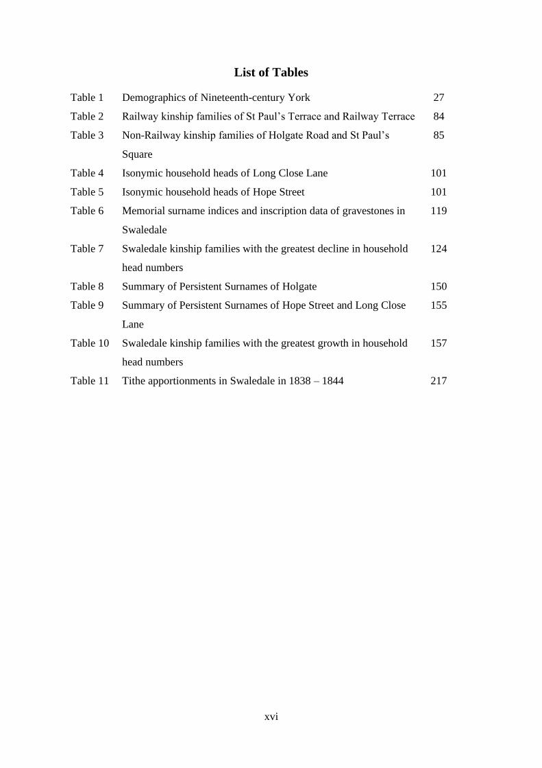
List of Tables
Table 1 Demographics of Nineteenth-century York 27
Table 2 Railway kinship families of St Paul’s Terrace and Railway Terrace 84
Table 3 Non-Railway kinship families of Holgate Road and St Paul’s
Square
85
Table 4 Isonymic household heads of Long Close Lane 101
Table 5 Isonymic household heads of Hope Street 101
Table 6 Memorial surname indices and inscription data of gravestones in
Swaledale
119
Table 7 Swaledale kinship families with the greatest decline in household
head numbers
124
Table 8 Summary of Persistent Surnames of Holgate 150
Table 9 Summary of Persistent Surnames of Hope Street and Long Close
Lane
155
Table 10 Swaledale kinship families with the greatest growth in household
head numbers
157
Table 11 Tithe apportionments in Swaledale in 1838 – 1844 217
1
A comparison of kinship family survival in York and Swaledale in
the nineteenth century
Chapter 1
Introduction: Kinship Families and Migration
‘There is an enormous literature on the family … - a reflection of its importance for the
continuation of society and the happiness, and misery, of individuals. The family, we are
constantly told, is the backbone of society. …’1
Structure
This thesis explores aspects of the history of family life, and in particular focusing on the
ways in which families have reacted and responded to forces often beyond their control. The
study concentrates on families energised by one such universal force, the impetus to migrate.
The work evolved from an interest in the structure and functioning of ‘kinship’ (or dynastic)
families, and the search for a way in which such families could be followed and studied over
time and between places.
Research studies in both the arts and sciences have traditionally approached the unknown
from a pre-existing knowledge base and then applied or devised methods to question
assumptions and test resulting hypotheses. This study, however, adopts the opposite
approach, whereby discussion and theories evolve from collected data.2 Demographic data
have been analysed by an innovative method or tool, a ‘surname index’. This method suffers
from the specific disadvantages and limitations particular to any tool, but it provides a
powerful way of comparing the structure of local communities. It has been used in this thesis
1 Opening introductory comment of Elizabeth Bott’s anthropological work: E. Bott, Family and Social Network:
Roles, Norms, and External Relationships in Ordinary Urban Families (1957, London, 1971), p. 1.
2 This approach has been applied to social science data, as proposed in B.G. Glaser and A.L. Strauss, The
Discovery of Grounded Theory (New York, 1999). One example of such an avenue of historical research into
migration is ‘cluster analysis’ of populations: N. Spencer and D.A. Gatley, ‘Investigating population mobility in
mid-nineteenth-century England and Wales’, Local Population Studies, 65 (2000), p. 47. Similar ideas have
been used in scientific studies, for example Darwin’s theory of evolution derived from data amassed from the
fossil record: J. Browne, Charles Darwin: Volumes I and II of a Biography (London, 2003). Pryce has provided
a detailed criticism of the methodology of relying on available data to study migration rather than the rigorous
testing of specific research questions or hypotheses: W.T.R. Pryce, ‘A migration typology and some topics for
the research agenda’, Family & Community History, 3 (2000), p. 65.

2
to identify and track a section of some populations and explore aspects of belonging and
ideas about migration.
Two areas of Yorkshire that witnessed mass migrations in the nineteenth century have been
chosen for study. They were selected specifically because of marked demographic and
economic contrasts between the two. The compact and densely-populated City of York
experienced large immigrations, while the dispersed population of rural Swaledale in the
Pennine hills suffered mass out-migration. The people of York and Swaledale are described
in the study in both quantitative and qualitative terms from the rich historical documentary
evidence.
A preliminary study of the application of the index to populations of two adjacent but
contrasting villages is presented before the index is applied to the migrant populations of
York and Swaledale. The full potential of the method can be seen in this example in the
varying responses of discrete sectors of the two villages to the same historical event, namely
enclosure of the fields, before selective facets of the index as defined by the available
evidence are used to study migrations.
Kinship and Migration
Kinship, by which is loosely meant ties of family and communal interest, is a concept that
changes radically over historical time and place.3 Migration is an event that uproots families
and impacts upon their economic survival. This thesis is an attempt to marry these two
notions with a study of ‘kinship families’ caught up in some mass migrations of the
nineteenth century.
Emigration from Britain reached a crescendo in the middle of the nineteenth century.4 These
mass movements of people were associated with variable dynamics and they were responses
to widely different pressures. There was also a vast internal readjustment of population in
this century as agriculture was divested of much of the rural population in the wake of urban
3 See M. Murphy, ‘Changes in family and kinship networks consequent on the demographic transitions in
England and Wales’, Continuity and Change, 25 (2010), p. 109; N. Tadmor, ‘Early modern English kinship in
the long run: reflections on continuity and change’, Continuity and Change, 25 (2010), p. 15.
4 E. Richards, ‘Malthus and the uses of British emigration’, in K. Fedorowich and A.S. Thompson (eds),
Empire, Migration and Identity in the British World (Manchester, 2013), p. 48. See also D.E. Baines, Migration
in a Mature Economy: Emigration and Internal Migration in England and Wales, 1861 – 1900 (Cambridge,
1986), pp. 178 – 212.

3
demographic development.5 The study makes urban and rural Yorkshire comparisons over
this period of marked agrarian and urban migration and change. Certain districts of Victorian
York (representative of different social and industrial elements) are contrasted with
Swaledale, in an attempt to answer questions about urban and rural changes and continuities,
and the effects of migration upon community and kinship family persistence.
Districts chosen for study in York are parishes in Walmgate and Micklegate, in which people
lived in polarised living conditions. Each of the study areas experienced significant
migration in the nineteenth century, namely Irish famine migrants moving into Walmgate,
railway migrant workers in Micklegate, and the out-migration of lead miners from Swaledale
as their industry collapsed. The fortunes of these migrants, and their integration into the
indigenous families, are an important part of the study.
An attempt is made in this thesis to apply a measure along the chain migration of kinship
families. Kinship families in this context are defined as several households in a community
headed by people with the same surname who were related by birth (ancestral lineage) or
marriage. A simple numerical index (surname index) is described in which the number of
specific surnames is assessed in relation to the total number of individuals in the population.
It is a measure of the density or concentration of surnames. A low surname index implies
that there were numerous people in the population with the same surname, and therefore
potentially several groups of individuals whose members were related by birth or marriage.
These indices provide no more than a number which can be used to compare populations;
they provide no information about specific families. Once changes in the density in census
returns of household heads with the same surname (isonymic heads) over the nineteenth
century have been plotted by surname indices, however, individual kinship families are found
and examined by reference to household structures in the censuses and parish registers.
Kinship was of variable significance in different social groups and in different settings, and
was arguably of greatest significance in the lives of migrant families.6 Once having
5 R. Woods, The Population of Britain in the Nineteenth Century (London, 1992).
6 See, for example: M. Anderson, Family Structure in Nineteenth Century Lancashire (Cambridge, 1971), pp.
152 - 161; C. Pooley and J. Turnbull, Migration and Mobility in Britain since the Eighteenth Century (London,
1998), pp. 299 – 317; and ‘Family employment, paternal impact and family migration’ in S. McMullon,
‘Migration to Fletton 1841 – 1911: An exploration of family migration, the creation of community and social
mobility through marriage’ (unpub. PhD. Thesis, University of Leicester, 2019).

4
identified these families, this thesis sets out to describe them in different rural and urban
contexts characterised by migration. Migrant families, having overcome any uncertainty of
travel, may have moved with or followed kin to the same location. What induced kinship
families to migrate, and in particular if and why related households should migrate together,
are the central questions of this thesis.
Research Questions and Outline of Chapters
Several research questions are posed and answered in this thesis:
Question 1: Did the nature of kinship bonds and kinship families differ in urban and rural
contexts?
Question 2: Is there a simple reproducible way of finding and tracking kinship families in
populations affected by migration?
Question 3: What were the motivations of kinship families to migrate into York or out of
Swaledale?
Question 4: Was there a pattern of migration of kinship families into York and out of
Swaledale?
Question 5: Did kin move together in a chain migration?
Question 6: How did migrant kinship families interact with their new community, and did
migration change these kinship bonds?
The nature of kinship bonds and kinship families in urban and rural contexts is addressed in
general terms in the historiography of this Introduction (Chapter 1).
The concept and calculation of surname indices are described in depth in Chapter 2 (Surname
Indices: Concept and Application), as they are applied to people enumerated in decennial
censuses, fathers identified in baptismal parish registers, or the deceased memorialised on
churchyard gravestones. The major theoretical and practical disadvantages of surname
indices are discussed at some length. A range of surname indices derived from populations in
two rural parishes near York are then described in detail in order to show how the
methodology may highlight different reactions of rural communities to a major historical
event, namely enclosure of the fields.

5
The surname indices plotted from census data of four streets in Holgate and two streets in
Walmgate in York are presented in Chapter 3 (Surname Indices and Migration: Kinship
Families of York). Differing trends in the migration of kinship families into these streets are
shown, followed by detailed histories of some individual kinship families. In the urban
parishes of York the surnames of all the heads of household of the four streets in Holgate and
the two streets in Walmgate were retrieved from the decennial census returns, and kinship
families are identified as those families with a surname shared by at least two related heads of
household in a street at any census. The kinship families in Holgate are further subdivided
into those that had an employment connection on the railway, and those that did not. This
analysis of the two streets in Walmgate yielded many more isonymic families than could be
described in any detail. Accordingly only those isonymic families with the greatest number
of family heads enumerated from all the censuses between 1841 and 1901 were chosen for
study in each street. The families in Walmgate were further subdivided into those whose first
arrival was born in Ireland, and those who were born elsewhere.
The surname indices plotted from census data in Upper Swaledale are presented in Chapter 4
(Surname Indices and Migration: Kinship Families of Swaledale), together with indices
derived from baptismal registers and gravestones and data on household composition. All of
the families identified in the census returns of the nineteenth century in the dale are kinship
families, in the sense that every head of household shared a surname with numerous other
heads in a complex web of descent and intermarriage. No isolated families were identified in
any census return. This is a reflection not only of the larger geographical area and larger
population than either of the districts of York studied, but also a relatively high rate of
endogamy. Faced with an overwhelming number of kinship families, the thesis examines the
trajectories of the five largest families in 1841 that subsequently declined in strength either
within the dale and/or by emigration.
Households that persisted over prolonged periods of time are compared between streets of
Holgate and Walmgate in Chapter 5 (Persistent Families of York and Swaledale), and eleven
kinship families that grew in size in Swaledale are compared with kinship families that
diminished in size over the second half of the nineteenth century.
An attempt is made in Chapter 6 (Community and Kinship Families in York and Swaledale)
to describe changes in the communities of Holgate, Walmgate and Swaledale over the course
6
of the century that had a bearing on resident families in the wake of migrations into York and
out of Swaledale.
In a summary of responses to the research questions outlined above, Chapter 7 (York and
Swaledale: Urban and Rural Comparisons) draws together and compares the surname
indices and kinship family characteristics in the migrant populations moving into York and
out of Swaledale.
Historiography: Rural and Urban Kinship Families in the Nineteenth Century
This section presents a discussion about how families functioned within their wider
community, and in particular about the importance of kinship.7 It explores the historiography
of kinship in both the rural and urban settings, and then looks at ‘core families’, a close-knit
subset of family networks that are described in English rural parishes. Whether core families,
or families with similar attributes, lived also in the town or city community is a further
consideration.
An influential theory on rural and urban kinship changes was proposed by Talcott Parsons.8
His thesis was that the process of industrialisation fragmented the family, first by disrupting it
from kinship networks.9 The traditional view of family structure in preindustrial England
was that households consisted of large extended families comprised not only of parents and
children but other related kin. It was argued that industrialisation of a community would
result in the disintegration of this family group into smaller nuclear families consisting only
of parents and their unmarried children. Such nuclear families, organised on so-called
structural functionalistic terms, would be better suited to an industrial society, enabling their
7 For discussions about the family and kinship, see for example M. Anderson, ‘The social implications of
demographic change’, in F.M.L. Thompson (ed.), The Cambridge Social History of Britain, 1750 – 1950:
Volume 2. People and their Environment (Cambridge, 1990), p. 46 – 56.
8 T. Parsons, Sociological Theory and Modern Society (New York, 1967).
9 M. Segalen, Historical Anthropology of the Family (Cambridge, 1986), pp. 73-99. Parson’s work from the
1940s and 1950s has been criticised because it was not based on field research and it was confined to the middle
class (Bott, Family and Social Network, p. 115). A major flaw seen in his theory is the assumption that families
changed only in response to economic developments, ignoring the possibility that families could shape historical
processes; see L. Davidoff, M. Doolittle, J. Fink and K. Holden, The Family Story: Blood, Contract and
Intimacy, 1830-1960 (Harlow, 1999), p. 24.

7
members to move freely to where the economic system needed them.10 This ‘master
narrative’ was revised in the 1960s to the 1980s, when it was argued that the nuclear family
and relatively weak kinship ties enabled modernisation and industrialisation to take place.
The major difference then between the master narrative and the revisionist approaches lies in
chronological and causal features.11
Studies of urban families, however, have found considerable historical variation on this
theme, and it is impossible to make generalisations about changes in family structure or size.
Laslett among others has found that the nuclear family was typical of English society from at
least the middle ages. He pronounced in 1972, however, that ‘… it would be questionable to
assert that the transformation of English society by industrialisation was accompanied by any
decrease in the size of the average household until very late on in that process’.12 Janssens
carried out a dynamic study of families in a nineteenth-century Dutch town overtaken by
migration and a process of industrialisation. Her study examined changes in family life-cycle
patterns. She addressed the question whether industrial turmoil loosened kinship ties or
indeed activated families’ extended kin networks. By looking in detail at the life cycles of
two groups of families separated by several decades of urbanisation, the study assessed the
inclusion of kin members into the households. The time kin resided with a family was
determined by a number of factors, including the wish to pass down the family property to
the next generation, the boarding of young migrant kin in search of employment, mortality
characteristics and the passage into old age of solitary parents, and the age at which children
married and left the family home. Janssens concluded that the process of industrialisation
was indeed responsible for a considerable strengthening of kin co-residence.
Janssens also looked in great detail at the reasons families chose or were obliged to take kin
into their household. The main reason for inviting parents into the household was their
10 A. Janssens, Family and Social Change: The Household as a Process in an Industrializing Community
(Cambridge, 1993), pp. 1-6. See also S. Ruggles, Prolonged Connections: The Rise of the Extended Family in
Nineteenth Century England and America (Madison, 1987), pp. 127 – 134.
11 See P. Laslett, ‘Introduction: the history of the family’, in P. Laslett and R. Wall (eds), Household and Family
in Past Time (Cambridge, 1972), p. 1; and Tadmor, ‘Early modern English kinship’, p. 15. See also Wall’s
concept of an adaptive family economy in R. Wall, ‘Work, welfare and the family: An illustration of the
adaptive family economy’ in L. Bonfield, R.M. Smith and K. Wrightson (eds), The World We Have Gained
(Oxford, 1986).
12 Laslett and Wall, Household and Family, p. 126.

8
failing health or poverty. Towards the other end of the family cycle, the balance was tipped
and married children would move back into the parental home to strengthen its economic
base.13 The breakdown of a rural economy towards the end of the nineteenth century in this
Dutch community had no major impact upon family behaviour. Industrialisation did not
dissolve the ties of kinship. The increasingly dynamic behaviour of young people, on the
contrary, stimulated rather than inhibited the formation of the extended household. The
working class formed smaller extended families than the upper classes, due largely it was
argued to the latter's larger cohesive kin network. The middle classes in this work were
championed as the bastions of family and urban kinship. Clearly Janssens’ large detailed
study of an urban community experiencing industrialisation does not bear out the predictions
of Parsons’ theory of changes in family structure.
The frequency of extended family households probably increased from pre-industrial times
until the late nineteenth century. Ruggles estimated that the proportion of extended
households doubled between 1750 and about 1875 in England, and that about one fifth of
households included extended kin between 1850 and 1885. Most of these households came
to consist of nuclear families together with parents or siblings of the husband or wife.14
Schürer has widened this debate, confirming that extended family households became more
common in the later nineteenth century, and that the proportion of such households changed
with place.15 Farmers were among the social group with the highest proportion of extended
households. The nature of family support in Schürer’s study also changed over time. Reay
has thrown light on the role of village extended and kinship families in the rural Blean area of
Kent in the nineteenth century. His work challenged the orthodoxies associated with the
‘autonomous nuclear family’. The analysis of complex and extended household structures
balances the argument that geographical mobility at the time weakened kinship, released
children from parental influence, and encouraged them to rely on their own efforts. It was
common in the Blean for farming households to pass through an extended period with
13 Janssens, Family and Social Change, pp. 24-28 and 78–95.
14 Ruggles, Prolonged Connections, pp. 4 – 9.
15 K. Schürer, E.M. Garrett, H. Jaadla and A. Reid, ‘Household and family structure in England and Wales, 1851
– 1911: continuities and change’, Continuity and Change, 33 (2018), p. 365. Laslett set discussions about the
dynamics of family size and the opportunities for marriage in P. Laslett, ‘Misbeliefs about our ancestors: The
absence of child marriage and extended family households from the English past’ in The World We Have Lost
further explored (London 1965, 1994 reprint), pp. 81 – 105.

9
resident kin. Reay surmises that extended families may have served differing economic and
social purposes according to family position and status. The extended family of the villager
was a means of conserving land and caring for older family members. The economies of the
small farmers’ household, where all family members played their role from a very early age,
were adaptable to the needs of kin and encouraged longer term residence.16 There were clear
differences in the social status of households with or without resident kin. The households of
labouring families predominated among those families with kin links. His study provided
strong evidence that kin links were a significant factor in daily life in a rural community.
Moving away from households listed in census records, King has shown through a study of
poor law records in early nineteenth-century Lancashire that there was constant redistribution
of kin between related households, which consequently varied in both form and size.17
Ruggles had concluded that demographic change was critically important to the rise of the
extended family, and considered the possible motives for living in such a form: the
agricultural way of life, a means of coping with a lack of property, or a rise in the standard of
living. He rejected the notion that these factors were sufficient to account for the growth of
extended families; he proposed that the insecurity and sentimentality felt by Victorian
families influenced their choice of this family life.18
The move to an urban environment produced several changes in the households of migrant
Irish people, a focus of much of this thesis. In the decades before the potato famine, most
rural Irish families were nuclear and similar in composition to preindustrial English
households.19 Fertility was probably higher in Ireland than in England in the decade before
the famine, however, and there were generally more children in pre-famine Irish households.
16 B. Reay, Microhistories: Demography, Society and Culture in Rural England, 1800-1930 (Cambridge, 1996),
pp. 156 -165. Winstanley has shown the growing importance in the late nineteenth century of the contribution
of small farms to agricultural production and of the family members who worked them: M. Winstanley,
‘Industrialization and the small farm: Family and household economy in nineteenth-century Lancashire’, Past
and Present, 152 (1996), p. 157.
17 S.A. King, ‘The English protoindustrial family: old and new perspectives’, History of the Family, 8 (2003), p.
21. For the Irish perspective see M. Cohen, ‘Peasant differentiation and proto-industrialisation in the Ulster
countryside: Tullyish 1690-1825’, Journal of Peasant Studies, 17 (1990), p. 413.
18 Ruggles, Prolonged Connections, pp. 127 - 135. See also C. Nelson, Family Ties in Victorian England
(Westport, 2007), pp. 1 – 14 for a discussion of the Victorian attitudes to the family, and L. Davidoff, Thicker
Than Water: Siblings and their Relations, 1780 – 1920 (Oxford, 2012).
19 L. Lees, Exiles of Erin: Irish Migrants in Victorian London (Manchester, 1987), pp. 123 – 130.

10
Extended families were usually transient within a minority of households. Lees has found
that the family patterns of the urban and rural Irish had diverged by the middle of the
nineteenth century. Whether they had migrated into a city at home or overseas, their
households retained the same structure but became smaller, they married earlier, and they had
fewer children.
Within the group of kinship families, those individuals related by genealogy, are found the
‘core’ families of English old villages. They were, in essence, those people who ‘were’ the
village; they cemented the local society.20 Membership of a core family fulfilled a basic
human need of belonging in their hierarchical society. In their seminal works on such
families and their communities, Jean Robin and Marilyn Strathern analysed in considerable
detail the interactions of all family groups between the mid-nineteenth century and mid-
twentieth century in the village of Elmdon in north-west Essex.21 Strathern suggested that
these were the people who rarely moved away.22 They were content largely to live out their
lives within the confines of the village. The typical villager displayed a vague constellation
of attributes, such as rural born and bred, narrow vision and horizon, and long association
with the place. The study posed numerous questions about these families, notably who
exactly were 'real village' people, were these the longest established families as checked
through the parish registers, were they the owners of land passed on by inheritance, and were
these the agricultural labourers of the community? The village society of Elmdon included a
number of subcultures based mainly on class, in which there was a hierarchical ladder of
respect and subservience. They had clearly differentiated patterns of life, marriage and the
burial of their dead, and many other distinct patterns of behaviour. Postles and Postles
suggest that core families became consolidated in the early modern period when a nucleus of
20 D. Hey, The Grass Roots of English History: Local Societies in England before the Industrial Revolution
(London, 2016), pp. 183 – 185; G. Redmonds, T. King and D. Hey, Surnames, DNA, and Family History
(Oxford, 2011), p. 217.
21 J. Robin, Elmdon: Continuity and Change in a North-west Essex village 1861-1964 (Cambridge, 1980).
Other studies of parishes in Wales and Cumberland in the twentieth century stress also the stability of some
rural populations, the cohesion of family, kindred and neighbours, and the sense of ‘belonging’ that these
communities could engender: A.D. Rees, Life in a Welsh Countryside: A Social Study of Llanfihangel yng
Ngwynfa (Cardiff, 1951); W.M. Williams, The Sociology of an English Village: Gosforth (London, 1956).
22 M. Strathern, Kinship at the Core: An Anthropology of Elmdon a Village in North-west Essex in the Nineteen-
sixties (Cambridge, 2009), pp. xi-xxxiv & 1-34.

11
surnames in the community became persistent, and that their behaviour on occasion may have
been a force for change rather than continuity.23
Birth into a ‘core’ family gave individuals in their own opinion an inalienable status, which
could set them apart from other villagers and provide some buffer and support against the
vicissitudes of daily life. There was a close connection between being a core family member
and one's image of belonging to the parish.24 The notion or concept of belonging to a place
outweighs the significance of the place itself, and a way of life or length of association with a
village is not crucial to these ideas. To be understood in relation to a local context and to be
seen as an integral part of a community is perhaps a fundamental human requirement of our
past and modern society.
Core families tended in the nineteenth century to be mainly farmers and farm labourers, who
married among themselves or a spouse from a nearby village. They chose to live in close
proximity, and indeed to be buried close together. They lived in villages through long
association among close kin relationships, and attachment to the community of one's birth
was often crucial. The core families of rural communities cannot be classified by a simple
system and divided from the rest of the population. Their exclusiveness and their boundaries
were largely a matter of image. They did not form a discrete segment of the population
which could be separated off sociologically from the rest of the village. They are best
regarded not as a set of families with specific kinship lines or precise tight genealogies but
rather as those families who 'belonged' to the fabric of the parish. These families are an
image, an idea, whose identity was deeply rooted in a particular place.25 To be born into a
core village family was arguably then great good fortune, if only because of the comfort in
numbers and group solidarity it could provide.
23 S. and D. Postles, ‘Surnames and stability: a detailed case study’, in D. Hooke and D. Postles (eds), Names,
Time and Place. Essays in Memory of Richard McKinley (Oxford, 2003), p.193. Furthermore, close kin links
may also be found in an area which had been occupied for generations by the same families without a
corresponding growth of social relationships based upon them (Rees, Life in a Welsh Countryside, p. 73).
24 K.D.M. Snell, Parish and Belonging: Community, Identity and Welfare in England and Wales 1700 – 1950
(Cambridge, 2006), pp. 94 – 95 & 108; Hey, The Grass Roots of English History, pp. 183 – 185. See also D.
Maund, ‘Territory, core families and migration: a Herefordshire study’, The Local Historian, 49 (2019), p. 221;
and P. Batman, Four Faces: The Batman Family of York (York, 2014), pp. 44 – 63.
25 Strathern, Kinship at the Core, p. 147; M. Strathern, After Nature: English Kinship in the Late Twentieth
Century (Cambridge, 1992), p. 11.

12
Core families and kinship networks were clearly of importance in village society, but whether
they existed and were of such importance in industrialised urban societies is open to
question.26 Urban societies, geared towards an industrial mode of production, arguably may
not have required or developed kinship families beyond the domestic group. This section
explores now the role of kinship family networks in nineteenth-century towns and cities.
Anderson has shown that the smooth transition from rural to urban life was eased greatly by
some degree of functioning kin relationship. Those families who did not benefit from this not
only believed that they were, but often were in reality, at a disadvantage in terms of material
help and emotional support.27 This functional relationship was based on the principle of
mutual advantage, whereby kin weighed up the advantages and disadvantages of co-residence
or support rather than through any sense of family obligation. Close kin were prepared to
give practical support over the longer term, but more distant kin would tend to give day to
day help with mutual benefit only in the short term. Practical help has rarely been given to
distant relatives by right.28 Within urban working-class communities, the unpredictability of
industrial wage labour and high levels of migration favoured an increased dependence upon
kin.29 Unlike the rural economy, Anderson's study of Preston found that the working classes
with no ownership of property could utilise family and kinship relationships to provide more
secure employment. On the other hand, urban children were more liable to break family
bonds when life chances other than employment seemed a better prospect in relationships
outside the kin family.30 In marked contrast to the absolute dependence of family members
upon each other in a rural setting for crucially important needs, Anderson found more diverse
family behaviour in the urban scene.31 There was a steady flow of support and assistance
between kin who had stayed at home and those who had moved into the towns. The kinship
26 Bell and Newby discuss and quote ideas on ‘folk’ societies, in which ‘members … always remain within a
small territory …’ ‘In such a society there is little change, and members have a strong sense of belonging
together.’ They characterize urban society as ‘… lacking a strong sense of group solidarity …’ (C. Bell and H.
Newby, Community Studies (1971, London, 1975, p. 44).
27 Anderson, Family Structure, pp. 1-2.
28 J. Finch, ‘Do families support each other more or less than in the past?’, in M. Drake (ed.), Time, Family and
Community. Perspectives on Family and Community History (Oxford, 1994),pp. 94-99.
29 Janssens, Family and Social Change, pp. 110 – 158.
30 Anderson, Family Structure, pp. 123-124.
31 Anderson, Family Structure, pp. 96-99.
13
links were seemingly then not an archaic survival of rural core families, but rather new
responses or adaptations to new conditions. The networks in the new urban society derived
strength from their former stability and were able to reorganise in relation to other
associations, such as those of neighbourhood.
Returning in summary to Parsons’ theory, there is clearly no structural fit between the
changes to the society and the emergence of the isolated urban nuclear family. On the
contrary, the extended family form may even in some contexts have become more successful
as the process of industrialisation transformed social and economic structures. Offspring
often took advantage of accommodation in the parental home for longer because of the
greater availability of work nearby.32 Work on the extended households in urban life has also
noted that parents were often taken back into the family as long as they had something to
contribute in return.33 The number of kin in the extended household rose during
industrialisation up until the middle of the nineteenth century and has remained fairly
constant thereafter. The relatively small change which has occurred in household size as a
consequence of falling fertility is of more recent change than the industrial revolution.34 The
generalisation that an urban life should disrupt kinship networks by social isolation of the
nuclear family from kin has therefore been shown to be poorly founded.
Close kin clearly were important in the industrial town of Preston in Anderson’s ground-
breaking study. Just how important these family links were generally or in other contexts,
however, is open to question.35 In pre-industrial times of lower life expectancy, there were
32 Finch, ‘Do families support each other’, p. 93. See also Schürer, Garrett, Jaadla and Reid, ‘Household and
family structure’, p. 365.
33 Finch, ‘Do families support each other’, p. 102. The taking of children or parents back into the extended
household at different times reinforces the point that the composition of families could change significantly even
though the average size of the household could remain the same for centuries (Davidoff et al, The Family Story,
p. 37). Thomson reinforces this view somewhat in suggesting that impoverished elderly parents were not in
general taken back into the children’s home (D. Thomson, ‘The welfare of the elderly in the past: a family or
community responsibility?’, in M. Pelling and R.M. Smith (eds), Life, Death and the Elderly: Historical
Perspectives (London, 1991), p. 209.).
34 Finch, ‘Do families support each other’, p. 92. The Cambridge Group for the History of Population and Social
Structure has shown many long-standing continuities in family structure throughout industrial development and
population change (Davidoff et al, The Family Story, p. 32.).
35 Wall argues that a variety of evidence suggests that kin were of limited importance (R. Wall, ‘Economic
collaboration of family members within and beyond households in English society, 1600 – 2000’, Continuity
and Change, 25 (2010), pp. 98 – 101.

14
fewer relatives alive to provide help, and large numbers of the population did not have the
financial resources to do so.36 These considerations have led to the view that the community
or state rather than family and kin would support the disadvantaged and needy, particularly
the elderly.37 The proximity of kin, of course, was no guarantee that family would have made
use of them, but Reay provides ample evidence that people would turn to their relatives for
help.38 Grandparents took in illegitimate children, who often depended upon relatives for
support. Kin could provide economic support in times of hardship. Old age did not always
mean a total reliance on the poor law. Oral history testimonies from the twentieth century
from rural Kent provided insight into the kinship interactions which Reay suggests percolated
down from the nineteenth century. Anderson also notes, however, that although many people
managed to maintain relationships with their family, this was not always the case. Kin
relationships, and indeed communities, may be defined as much by antagonism, fear and
suspicion as by neighbourly good will. Some individuals came to the view that they
contributed either in monetary or other forms of support more to their family than the family
gave to them. Relatives could die without the knowledge or regard of their kin, having
withdrawn from the fold to form new and more profitable social relationships which
benefited themselves.39 Similarly, the co-residence or proximity of kin is not proof of a close
supportive network; it may merely reflect the limited availability of houses or lack of
information for families on housing vacancies.40 In other words, although kinship links
existed in urban life, this is no guarantee that the relationships were functional or beneficial.
36 P. Laslett, ‘Family, kinship and collectivity as systems of support in pre-industrial Europe: a consideration of
the ‘nuclear-hardship’ hypothesis’, Continuity and Change, 3 (1988), p. 153.
37 D. Thomson, ‘Welfare and the historians’, in L. Bonfield, R.M. Smith and K. Wrightson (eds), The World We
Have Gained (Oxford, 1986); Thomson, ‘The welfare of the elderly in the past’, p. 198. Thomson argues that
the Poor Law Act of 1601 placed limited legal duty to provide assistance upon the relatives of impoverished
elderly parents, but rather upon the poor law authorities. Snell and Millar argue that early nineteenth-century
English society paid higher benefits relative to income of the working class than was the case in the late
twentieth century (K.D.M. Snell and J. Millar, ‘Lone-parent families and the Welfare State: past and present’,
Continuity and Change, 2 (1987), p. 387.
38 Reay, Microhistories, p. 168. See also B. Reay, ‘Kinship and the neighbourhood in nineteenth-century rural
England: the myth of the autonomous nuclear family’, Journal of Family History, 21 (1996), p. 87.
39 Anderson, Family Structure, p. 66; Davidoff et al, The Family Story, pp. 78-79.
40 R. Dennis and S. Daniels, ‘Community and the social geography of Victorian cities’, in M. Drake (ed.), Time,
Family and Community. Perspectives on Family and Community History (Oxford, 1994), p. 214.

15
Aside from kin, was neighbourhood important to the town dweller? The degrees to which
residents stayed in the same house or moved away determined the character of social areas
and the stability of communities.41 The dominant form of tenure in the nineteenth century
was rented accommodation, with its associated implications for moving house. The Victorian
poor tended to move often but generally over short distances, while the middle classes were
rather less mobile.42 The middle-class families had more secure incomes and were more
likely to own the house in which they lived or rented accommodation on more secure terms
than the poor. The critical influence of mobility or persistence of families on community was
not the occupational status of these people, but the ownership or class of their housing. Rent-
paying working-class residents showed short distance moves and circular mobility because of
little emotional attachment to their dwellings and minimal removal costs, but often
commitment to their locality.43 Neighbourhoods varied in the extent to which residents
stayed or left. In some working-class districts of York, for example, only 21% of working-
class families in 1851 were recorded at the same address 10 years later.44 Communities were
most likely to develop where families had lived and worked in the same neighbourhood over
a lengthy period, and when neighbours were also kin.45 Affinity was felt by urban residents
even with a stranger who was known to have been born or brought up in the same street.46
The mobility of families within towns did not disturb this frequent neighbourly feeling.
Anderson found that women in Preston could be more dependent on their neighbours than
husbands, given the segregation of their roles and the callousness of some husbands.47
Women were more likely to maintain interest in female kin for daily support, and the men
more likely to help kin secure employment.48 Casual labourers with no permanent work may
41 M. Pacione, Urban Geography (2001, London, 2009), pp. 51-52.
42 R. Dennis, English Industrial Cities of the Nineteenth Century: A Social Geography (Cambridge, 1984), pp.
258-259.
43 Pooley and Turnbull, Migration and Mobility, pp. 51 – 91; Dennis and Daniels, ‘Community and the social
geography of Victorian cities’, p. 205.
44 Dennis, English Industrial Cities, p. 255.
45 Dennis, English Industrial Cities, p. 250.
46 R. Parkinson, On the Present Condition of the Labouring Poor in Manchester (London, 1841), cited by
Anderson, Family Structure, p. 103.
47 Anderson, Family Structure, p. 104.
48 Finch, ‘Do families support each other’, p. 100.

16
have been more dependent upon neighbours and local tradesmen than kin for temporary
credit in times of crisis. However, kin were generally preferred over neighbours or friends
for support, given the high population turnover of some communities.49 The terms under
which houses were occupied had considerable influence therefore on the residents’ concept of
neighbourliness. The sense of community was determined possibly by households who
moved only short distances, either because they chose to remain in a familiar comfortable
environment, or because they were constrained by financial pressures or ignorance of where
else to go. Arguably, however, whether neighbours stayed or left had less to do with the
families’ feeling of community than whether they shared with them the same workplace or
congregation in church or chapel.50
Kin could provide a structured link, which could form the basis of mutual help, and they
provided the main source of aid. Neighbours could not provide this reciprocal support in a
mobile society. Critical life situations such as sickness, unemployment, untimely death or
other disaster were common, leaving widows and orphans, and temporary or permanent
arrangements for the substitution of family roles were pressing issues.51 Kin were the most
active of those who could provide this assistance in times of crisis. The role of kin in helping
relatives find employment was important, but these other critical events further encouraged
people to remain in a functional kinship system. In nineteenth-century Preston, Anderson
found kin made strenuous efforts to be neighbours. Several couples chose not to live with
their parents, but nearby. He cites numerous examples of people who were probably related
and who lived in close proximity.52
Financial considerations and responsibilities also played their part in kin relations both in the
rural and urban settings. The children of rural core families often were dependent on their
parents for employment. They often benefited also from gifts from their parents during their
lifetime and inheritances, factors which helped bond children to their parents and in turn gave
49 Dennis and Daniels, ‘Community and the social geography of Victorian cities’, p. 213.
50 Dennis, English Industrial Cities, pp. 264-269.
51 Anderson, Family Structure, p. 136; P. Joyce, Visions of the People: Industrial England and the Question of
Class 1848-1914 (Cambridge, 1991), p. 158.
52 Anderson, Family Structure, pp. 56-60.

17
parents influence over them.53 These considerations made abandoning relationships with
family and kin a precarious affair. In the earlier part of the nineteenth century a change took
place in some regions in inheritance practices which affected the fortunes of children.54
Before this time families with wealth typically bequeathed heavily in favour of the eldest son,
but subsequently other children came to inherit roughly equal proportions from their parents’
resources. There was furthermore under the poor law a requirement for children to support
their parents financially. According to Finch, there is no good indication that people took on
automatic responsibility for infirm, unemployed or impoverished relatives. Financial
relationships between kin typically were two-way exchanges rather than one-way assistance.
This author also cites circumstances in which people tried to evade their financial
responsibilities to family and quotes examples of children distancing themselves from their
parents as a way of avoiding maintenance payments. Wall redresses the balance by citing
cases of children supporting disadvantaged parents even when they lived elsewhere.55
The discussion so far has assumed that kinship and neighbourhood ties were similar across
the social spectrum. However, different social groups could adopt different strategies in an
attempt to adapt or maintain their networks. Within the rural context, there were clear links
between family and social class. The larger the farm and the greater therefore the presumed
wealth, the larger and more complex were the family forms. Kinship recognition was deeply
engrained also in landed gentry culture.56 Social category is a major factor also in the
formation of relationships within the urban kinship group. Urban kinship families provided a
continuity of culture through the generations, particularly among the middle classes.57 In the
supposedly anonymous urban community also, status could replace a rural network of mutual
acquaintance. The town dweller may not have the long genealogy of the rural core family,
53 Anderson, Family Structure, pp. 120-123.
54 Finch, ‘Do families support each other’, p. 96.
55 Wall, ‘Economic collaboration of family members’, p. 93.
56 M. Rothery, ‘Communities of kin and English landed gentry families of the nineteenth and early twentieth
centuries’, Family & Community History, 21 (2018), p. 112; L. Boothman, ‘Studying the stayers: Kinship and
social status in Long Melford, Suffolk, 1661-1861’, Local Population Studies, 101 (2018), p. 4.
57 Morris has shown the importance of the ‘property cycle’ in relation to the life cycle of professional and
business men in nineteenth-century Leeds, and the role of family networks in mitigating personal and financial
risk: R.J. Morris, Men, Women and Property in England, 1780 – 1870 (2005, Cambridge, 2008); R.J. Morris,
‘Family strategies and the built environment of Leeds in the 1830s and 1840s’, Northern History, 37 (2000), p.
193.
18
and may have been identified by more visible criteria. For the rural worker, a trade was
commonly passed from father to son, but into the nineteenth century, as both father and son
were often hourly paid workers in different urban factories, a break in this transmission could
occur.58 Kinship, however, could provide a way into the labour market, especially with an
employee’s first job. Young people often had the opportunity to work in their home area,
once the great population movements of the Industrial Revolution were over. Nepotism
played its part in urban working-class life. In the rural setting, endogamy united kindred
groups of a similar social category; in the urban setting, interwoven family marriage
strategies might bring together two complementary businesses.59
Did the importance of kinship ties change over historical time? In the towns of the nineteenth
century institutionalised means of assistance and support were either inadequate or provided
only at a cost which entailed a significant disadvantage. It was thus vital for kin to make
every effort to keep in a reciprocal relationship with other kin if critical life situations were to
be eased.60 Towards the end of the century, the urban working class developed a more
functional and less manipulative orientation to kinship. The introduction of the old age
pension possibly transferred some of the economic burden of old age from kin, so that a
stronger commitment to kinship developed. Anderson argues that traditional community
solidarity could then become possible.61 He suggests that the urban working class has
evolved from a preindustrial kinship network weakened because the problems were
insuperable, to a functional system at the end of the century, to a modern setting where
58 Davidoff discusses the interplay of kinship and work in working-class communities: Davidoff et al, The
Family Story, pp. 116 – 117.
59 Davidoff notes that the middle classes relied on the trust funds of close kin, typically wives and female
relatives, to form business partnerships and foster their entrepreneurial ambitions: Davidoff et al, The Family
Story, p. 24.
60 Anderson, Family Structure, p. 137.
61 Anderson, Family Structure, pp. 178-179. The old age pension was introduced in limited form in 1908, when
people over 70 years old and subject to an income test and character reference were eligible (Finch, ‘Do families
support each other’, p. 103). Thomson, however, maintains that elderly persons in the mid-nineteenth century
received a weekly pension from the poor law authority with a relative value in excess of pensions paid by the
late twentieth century welfare state. His timetable of fluctuating benefit is that welfare for the elderly was at its
height in the early nineteenth century, and declined after 1870 when it was felt that the aged did not need or
deserve community assistance and kin were capable of helping them: Thomson, ‘The welfare of the elderly in
the past’, pp. 209 & 216.

19
kinship is again weakened because resources can cope with the urban family stresses and
strains.
Historiography: Rural and Urban Migrations in the Nineteenth Century
Family and neighbours thus all played their part in the urban milieu. These social networks
became particularly significant to newcomers or outsiders. Many authors have emphasised
the active role played by kinship families in immigrant, political, religious and other minority
groups.62 Contact with kin could soften harsh new contact with an alien society and provide
feelings of stability, belonging and identity. Migration of all societies presents new special
problems which must be confronted if the migrant is to adapt to a new community. Migrants
faced new problems which they could not overcome without some form of assistance.
Almost all studies in the urban industrial setting indicate that kinship bonds were a major
source of this help. The earliest studies of kinship among immigrants dealt with easily
identifiable groups. Firth examined working-class people in south London contrasted with an
ethnic group of Italian origin in the mid-twentieth century.63 He found that these families had
important and extensive relationships with their relatives. He coined the term ‘kin universe’
for the number of relatives of the family beyond any household, and found that the number
was usually greater than a hundred. Families migrating from a rural to an urban setting often
built up important kinship webs in the towns. Anderson contrasts this with the view that
migration tended to disrupt kinship bonds. His analysis of nineteenth-century Preston found
that a high proportion of migrants lived with kin and that many more lived near them.
Although kin could not provide solutions to all the problems of urban industrial life, they
remained the most important source of support for the majority of the population.64 The
migrants in Preston maintained some important relationships with their kin left behind in the
country, and some of their patterns of family structure in the town resembled their former
rural pattern. Town and country people could form one kinship network with movement of
62 For reviews see Pooley and Turnbull, Migration and Mobility; Tadmor, ‘Early modern English kinship’, p.
15. For a study of religious immigrants see J.A. Garrard, The English and Immigration, A Comparative Study of
the Jewish Influx 1880-1910 (Oxford, 1971), and for a study of kin in a minority group see M. Prior, Fisher
Row: Fishermen, Bargemen, and Canal Boatmen in Oxford, 1500 – 1900 (Oxford, 1982).
63 R. Firth (ed.), Two Studies of Kinship in London (London, 1956), p. 67.
64 Anderson, Family Structure, p. 61. Schürer suggests, however, that although Anderson found a high
proportion of extended households with co-residing relatives, Preston was an exceptional case (Schürer, Garrett,
Jaadla and Reid, ‘Household and family structure’, p. 395).

20
people from one to the other with exchange of services. Migrants into Preston moved along
kinship channels opened up for them by kin and help flowed in both directions.65 Immigrant
minority groups in towns in general remained within a limited and familiar district, whereas
indigenous families were both able and willing to move more freely within the town.66
People born in the same community tended to move into the same street of the town, even if
they were not kin.67 They could then provide help for new arrivals in many ways, including
temporary accommodation, employment and help with adaptation to an urban life. Clustering
of migrants could provide comfort against the culture shock of life in a new environment.
Relatives making the effort to welcome immigrants may also have benefited financially by
their arrival. On the other hand, migration may have hindered the ability of kin to provide
regular assistance.68 Kinship in such immigrant groups had both positive and negative
aspects in the host society, at one and the same time a help to integration but slowing also the
process of assimilation into the dominant group.
Finally it is important also to consider and explore some aspects of the motivations and
psychology of migrant families, and in particular of kinship families tempted or induced to
migrate, within the shores of England or overseas in the nineteenth century.69 Migration
reached a peak in the middle decades of this century.70 Uprooting and moving a family
within the British Isles was always simpler than emigration. Most emigrations began with
the imperceptible movement of small numbers of people over many years, which evolved
over the course of time into a massive aggregate exodus. One of the most eminent
philosophers of emigration was Thomas Robert Malthus (1766-1834). Arguing in his writing
that population tended always to expand to the limits of subsistence, he urged emigration as a
solution to the problems of poverty and overcrowding in Britain in the late eighteenth and
65 Anderson, Family Structure, pp. 79 and 159-160.
66 Dennis, English Industrial Cities, p. 261.
67 Anderson, Family Structure, pp. 101 and 158.
68 Wall, ‘Economic collaboration of family members’, p. 85.
69 C.G.N. Mascie-Taylor and G.W. Lasker, Biological Aspects of Human Migration (Cambridge, 1989) provides
an overview of genetic and evolutionary aspects of migration. Pooley discusses the individual experience and
impact of migration in C. Pooley, ‘How people moved: researching the experience of mobility in the past’,
Local Population Studies, 82 (2009), p. 63.
70 Richards, ‘Malthus’, p. 49.

21
early nineteenth century.71 Ernst Georg Ravenstein (1834-1913) is perhaps a lesser-known
authority on the subject of population dynamics who published his ‘laws’ of migration in the
late nineteenth century.72 Unlike the works of Malthus, however, it is possible to scrutinise
the movements of individual families in the light of his eleven laws. His first law states that
most migrants travelled only a short distance. He suggested also that these individuals or
families did not travel directly to their ultimate destination, but by a series of steps of
‘intervening’ opportunities.73 Migrants moving long distances, on the other hand, tended to
settle in a large centre of commerce or industry, and these workers in general possessed more
skill or education than short-distance migrants. The basis of Ravenstein’s fifth law was that
people born in towns were less liable to migrate than those born in the countryside, and his
sixth that women were more likely than men to migrate within the region of their birth. This
he attributed to the urban demand for domestic servants, the movement of women at
marriage, and the dearth of opportunities for female rural employment. Most migrants were
adults, whole families emigrating only under exceptional circumstances. Nineteenth-century
towns grew more by in-migration than by indigenous expansion. These urban migrants
tended to be young and then married in the towns, where their offspring enlarged the
population further. The rural exodus to the towns gathered momentum as industry and
commerce developed and as transport improved, the basis for Ravenstein’s ninth and tenth
laws.74
71 Richards, ‘Malthus’, pp. 43-45. Richards suggests that Malthus’ predictions about population and emigration
were not borne out by history and that his arguments were incorrect.
72 E.G. Ravenstein, ‘The laws of migration’, Journal of the Statistical Society of London, 48 (1885), p. 167; E.G.
Ravenstein, ‘The laws of migration’, Journal of the Royal Statistical Society, 52 (1889), p. 241.
73 Evidence of step-migration is discussed in: P. Aslett et al, Victorians on the Move: Research in the Census
Enumerators’ Books 1851 – 1881 (Thornborough, 1984), p. 14. Schürer cites Clark’s notion of ‘subsistence’
and ‘betterment’ migratory movements, the former undertaken by vagrants and paupers in an undirected fashion
often over long distance and the latter predetermined short distance moves (K. Schürer, ‘The role of the family
in the process of migration’, in C.R. Pooley and I.D. Whyte (eds), Migrants, Emigrants and Immigrants
(Cambridge, 1991), p. 108; P. Clark, ‘The migrant in Kentish towns 1580 – 1640’, in P. Clark and P. Slack
(eds), Crisis and Order in English Towns 1500 – 1700 (London, 1972), p. 117).
74 Ravenstein’s laws are discussed in: D.B. Grigg, ‘E.G. Ravenstein and the Laws of Migration’, in M. Drake
(ed.), Time, Family and Community. Perspectives on Family and Community History (Oxford, 1994), p. 147. 1.
The majority of migrants go only a short distance; 2. Migration proceeds step by step; 3. Migrants going long
distances generally go by preference to one of the great centres of commerce or industry; 4. Each current of
migration produces a compensating counter current; 5. The natives of towns are less migratory than those of
rural areas; 6. Females are more migrate through than males within the kingdom of their birth, but males more
frequently venture beyond; 7. Most migrants are adults: females rarely migrate out of their county of birth; 8.

22
Ravenstein’s eleventh law, namely that the major causes of migration were economic, is, on
the face of it, obvious. Progressive rural unemployment set in after 1850, and the population
fell in many places in the face of intractable persistent poverty.75 This stagnation and decline
often reflected population pressure on the availability of land. In many rural areas the
population was smaller in 1901 than it had been 50 years before. However, inert people in
the countryside experiencing considerable hardship often chose to remain on the land despite
their poor living standards. The tide of rural out-migration showed little correlation with
prosperity in agriculture in the second half of the nineteenth century. When economic
motives predominated, the ‘push’ of increasing poverty in the countryside was balanced
against the ‘pull’ exercised by the prospect of higher wages elsewhere. The decision to
migrate then represented the triumph of hope over unhappiness.76 The pressure to migrate,
however, was not always necessarily or primarily economic. For women one of the
motivations may have been the prospect of marriage. The lure of town life held attractions
for some country dwellers. Life was more intense in the town than the village, and the young
in their prime could escape from the old, the traditional family ties, and the severe restraints
on behaviour inherent in rural family life. There was also of course greater opportunity to
move in the later nineteenth century, when a tangible effect of the railway was to enable more
people to move short distances.77
Demographics of York in the Nineteenth Century
This section begins with a broad overview of some important changes which occurred in the
population of York across the nineteenth century, both in its size and in its composition. In
the two centuries before the Victorian era York was an agricultural and social centre of
Large towns grow more by migration than by natural increase; 9. Migration increases in volume as industries
and commerce develop and transport improves; 10. The major direction of migration is from rural areas to the
towns; 11. The major causes of migration are economic.
75 Richards, ‘Malthus’, pp. 54–55. J.A. Banks, ‘The contagion of numbers’, in H.J. Dyos and M. Wolff (eds),
The Victorian City: Images and Realities, volume 1 (London, 1973), p. 105. Grigg, ‘Ravenstein’, p. 158. For a
discussion of the migration of families in rural depopulation, see also: Schürer, ‘The role of the family’, p. 106.
76 Richards, ‘Malthus’, p. 46. The social and economic consequences of enclosure, agricultural depression and
unemployment in Victorian rural England are also described in G.E. Mingay, Rural Life in Victorian England
(Stroud, 1998).
77 Banks, ‘The contagion of numbers’, pp. 112-117.

23
northern England.78 It was the largest corn and market town in the country in the eighteenth
century. In fact the City’s only trading role at the beginning of the nineteenth century was as
a hub where countryside produce could be brought for sale and goods and services sold.79
Small family concerns produced what little manufacturing there was. Gentry families had
been attracted to build large town houses, and domestic servants made the biggest group of
workers in the City. The fortunes and affluence of York at this time were in decline.80 The
City corporation’s neglect of the Ouse navigation had hindered the establishment of factories,
and it no longer held the status of the northern metropolis which it had enjoyed in the
eighteenth century.81
In the early nineteenth century the inhabitants of York generally were born within the City
walls or surrounding prosperous country district. The population grew from 16,846 in 1801
to 28,842 in 1841 (an increase of 71%), attributed almost entirely to indigenous growth and
influx from towns and villages nearby. The North Eastern Railway arrived in York in 1839,
and thereafter the population of the City grew over three- and four-fold by 1881 and
1901from its size at the start of the century.82 The City had formerly been occupied by
‘resident gentry who relied for their connections with the outer world upon posting and
coaches’.83 With the arrival of steam the gentry could now travel and they left the City.
River transport, which for centuries had played to York’s advantage, was superseded by the
78 P. Brears, ‘York and the gentry: The York season and the country house’, in E. White (ed.), Feeding a City:
York. The Provision of Food from Roman Times to the Beginning of the Twentieth Century (Totnes, 2000), pp.
150-167. See also W.A. Armstrong, ‘A note on the household structure of mid-nineteenth-century York in
comparative perspective’, in P. Laslett and R. Wall (eds), Household and Family in Past Time (Cambridge,
1972), p. 205.
79 H. Murray, ‘Rebirth and growth: Nineteenth-century York’, in E. White (ed.), Feeding a City: York. The
Provision of Food from Roman Times to the Beginning of the Twentieth Century (Totnes, 2000) , pp. 187-202.
80 Brears notes that York was described as ‘Poor, Proud and Pretty’ by the mid-nineteenth century (Brears,
‘York and the gentry’, p. 167). Prosperity in the form of a flourishing tourist industry was not destined to return
to York until the 1960s and 1970s.
81 The management of the affairs of the Ouse Navigation by the City Corporation are documented further in A.
Armstrong, Stability and Change in an English County Town: A social study of York 1801-51 (Cambridge,
1974), pp. 23 – 24.
82 S. Rankin and D. Thompson, York 100 1877-1977: The Story of a Station (York, 1977), p. 3. The York and
Midland Railway Company formed in 1835, an Act of Parliament was obtained in 1836, and the first train ran
on 29 May 1839. 83 B.S. Rowntree, Poverty: A Study of Town Life (1901; Bristol, 2000), p. 9.

24
railways which allowed goods to be transported easily to all inland towns. With the railway
boom there came to York new and expanding industries, particularly confectionery.
The York Registration District of the mid-nineteenth century consisted of seven subdistricts,
four of which, namely Skelton, Flaxton, Dunnington and Escrick, comprised only rural areas
with no urban component.84 The other three subdistricts, namely Bootham, Walmgate and
Micklegate, although each also lay predominantly in the countryside around the City,
encompassed between them the entire urban population of York. Elite family groups in
Victorian York tended to reside in the central districts. There were some differences in
residence according to family, occupational and ethnic groups. These configurations had
deep historical roots in the City. However, distinct neighbourhoods of similar class residents,
such as exist in modern York, did not exist in the Victorian City. Working class ghettos were
not a feature of York, and the professional and wealthy merchant classes had not abandoned
less salubrious central districts of the City. Most subdistricts housed a significant
representation of both higher class and labouring residents. However, these socially polarised
families were not distributed randomly, and there were broad differences in social class
between the subdistrict of Walmgate on the one hand, and Bootham and Micklegate on the
other (Figure 1).85
Armstrong’s classic monograph on the population of York over the first half of the nineteenth
century shows that although there was a tendency for different social classes of families to
mix in different areas of the City, there was some class differential between Walmgate and
Bootham/Micklegate. Significantly more household heads that had been born in York in
social classes I and II lived in Bootham or Micklegate in 1851 than in Walmgate. The
distribution of the lower social classes at that census, however, was more evenly spread, and
in fact, there were relatively more lower social class families in Micklegate than in
Walmgate. Armstrong's analysis of the Registrar General’s annual reports shows that death
rates in Walmgate were consistently higher than those of the other two subdistricts between
1843 and 1851, and that Micklegate had a lower mortality throughout this period than the
84 Armstrong, Stability and Change, pp. 76 – 81. Similarly in the nearby City of Leeds, Ward has found
residential patterns of people with middle-class occupations alongside working-class neighbours between 1841
and 1871: D. Ward, ‘Environs and neighbours in the “Two Nations” residential differentiation in mid-nineteenth
century Leeds’, Journal of Historical Geography, 6 (1980), p. 133.
85 The growth of population in York, including the Irish immigrants, is described in: Armstrong, Stability and
Change, pp. 76 – 107.
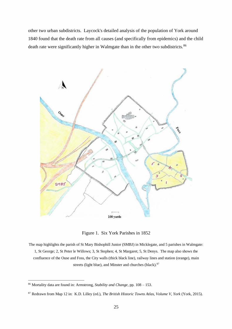
25
other two urban subdistricts. Laycock's detailed analysis of the population of York around
1840 found that the death rate from all causes (and specifically from epidemics) and the child
death rate were significantly higher in Walmgate than in the other two subdistricts.86
Figure 1. Six York Parishes in 1852
The map highlights the parish of St Mary Bishophill Junior (SMBJ) in Micklegate, and 5 parishes in Walmgate:
1, St George; 2, St Peter le Willows; 3, St Stephen; 4, St Margaret; 5, St Denys. The map also shows the
confluence of the Ouse and Foss, the City walls (thick black line), railway lines and station (orange), main
streets (light blue), and Minster and churches (black).87
86 Mortality data are found in: Armstrong, Stability and Change, pp. 108 – 153.
87 Redrawn from Map 12 in: K.D. Lilley (ed.), The British Historic Towns Atlas, Volume V, York (York, 2015).

26
York in 1841, before the arrival of the famine immigrants, housed 430 people who had been
born in Ireland.88 The Irish were distributed throughout all but one of York's 34 parishes,
although it was notable even then that the immigrants tended to concentrate in the poorest
districts. Finnegan notes that their concentration was even more apparent in individual streets
and courts in the City. These immigrants, however, were represented in every social class,
although more than a quarter were present in the lowest social class. They were also
employed in a wide variety of occupations, and less than a quarter of this population were
labourers. The small Irish community of York in 1840, although living in overcrowded
unhealthy slums similar to those of the non-Irish poor, did not stand out from the rest of
York's population.
Armstrong took data from his own calculations of mortality rates, the value of properties
from rate assessments and property taxes and the proportion of all higher class household
heads, and confirmed that Walmgate was indeed the least favourable subdistrict as regards
mortality rates. The correlation is confirmed between the worst drainage, highest death rate,
and the highest proportion of poor households. A compilation of some of York’s nineteenth-
century demographics is presented in Table 1. However, Amstrong has shown that the
subdistrict with the most favourable mortality rate, namely Micklegate, was not the
subdistrict where individual wealth was highest and where most upper-class householders
lived. Micklegate housed a large component of lower middle-class families and respectable
artisans. Bootham, in fact, had the highest percentage of upper-class households, and the
highest rateable and taxable assessments of its properties. Although Bootham boasted several
fashionable high-class streets in the City, it also contained the crowded market and
commercial district of the City and one particular quarter, the Bedern, where squalor and
poverty surpassed even the worst streets in Walmgate. Armstrong has argued that higher-
class people tended to live in more sanitary districts of the City, but it was place of residence
rather than social class and wealth which was more important in explaining differential
mortality.89
88 See F. Finnegan, Poverty and Prejudice: A Study of Irish Immigrants in York 1840-1875 (Cork, 1982), pp. 5 –
16 for York’s pre-famine Irish community.
89 Armstrong, Stability and Change, pp. 129 – 139.

27
WALMGATE BOOTHAM MICKLEGATE
1 % York-born household heads in Class I-II in 1851
census sample
12 29.2 27.3
% York-born household heads in Class IV-V in 1851
census sample
21.6
19.1
25.5
2 Death rate per 1000 in Walmgate (with Hungate) in
1898
27.8 Death rate across York
18.5 in 1898
Infant death rate per 1000 in Walmgate (with
Hungate) in 1898
247
Infant death rate across York
175 in 1898
3 Death rate per 1000 in 1839-41 27.7 25.4 25.6
Infant death rate per 1000 in
1839-41
104.1
100.9
84.0
4 Average mortality rate 1841-51
% of all rate assessments £10 or over 1850-51
Annual value of house property divided by population
1841
% Household heads in Class I-II in 1851 census
sample
27.2
15.3
£2.41
15.8
24.9
56.2
£3.35
27.9
21.4
35.7
£3.10
24.2
5 Crude birth rates 1839-41
Births per 1000 females aged 15-44 in 1850-52
Illegitimate births per 1000 females aged 15-44 in
1850-52
32.2
157.4
12.2
28.9
94.9
7.2
27.1
109.3
5.4
6 % of children attending school by age group in 1826
Aged 6-10
Aged 10-12
70.8
61.8
78.1
70.2
78.3
74.3
1851 Census 1901 Census
Population Size No. Irish born Population Size
Walmgate
St George
2095
412
2212
Micklegate
SMBJ (part of)
3526
121
Holgate
(Part of SMBJ) 571
(St Paul’s) 3302
Table 1. Demographics of Nineteenth-century York
28
Fertility, however, may have depended more on the social than the physical environment.90
Where families lived in York had more influence on their health than their income or status.
Some higher class residents of the City were probably influenced by commercial or other
factors to live in districts which generally fell short of their expectations.
The 1840s were a turning point in the demographic history of York. This decade heralded
two mass migrations into the City, one driven by the Industrial Revolution and the other by
an ecological disaster. The arrival of the railway brought not only a revolutionary mode of
transport, but also an expansive workforce to service this new burgeoning industry. The
other influx was not a workforce, but a desperate impoverished people fleeing the potato
famine in Ireland.
The first wave of starving famine immigrants began to arrive in York in late 1846.91 The
Irish in York in 1851 have been estimated at 7.2% of the population, a comparable level with
other towns in central and north east England.92 The Irish arrivals tended to cluster in the
lowest two social classes, and they tended to form a homogeneous group of low social class
people wherever they were encountered. There was a high proportion of Irish immigrants in
Walmgate Ward. The parishes of St George, St Margaret, St Peter le Willows and St Dennis
were heavily populated by these immigrants. Other enclaves of these people were in the
Bedern and in the Water Lanes in St Mary Castlegate. They tended to colonise particular
streets or blocks of buildings, possibly adopting distinctive cohesive residential patterns at the
street or even court level.
The other wave of mass migration into York in mid-nineteenth century was the employees of
the North Eastern Railway Company. Just as Walmgate attracted poor Irish immigrants,
Micklegate tended to attract skilled railwaymen, many of whom came from the Northern
90 E. Garrett, A. Reid, K. Schürer and S. Szreter, Changing Family Size in England and Wales: Place, Class and
Demography, 1891 – 1911 (Cambridge, 2001), pp. 11 and 399. Szreter has shown that the same social class
could show different fertility depending upon place of residence. 'Where a couple lived largely dictated the life
chances of their children; who they lived amongst provided their guidelines for “acceptable” behaviour in … the
number of children they were likely to have.’
91 Finnegan, Poverty and Prejudice, pp. 5 – 38.
92 Finnegan, Poverty and Prejudice, p. 69; levels in other towns have been estimated as: Manchester 13.1%,
Bradford 8.9%, Leeds 4.9%, Preston 7.4% and Bolton 7.3% (R. Swift (ed.), Irish Migrants in Britain 1815 –
1914: A Documentary History (Cork, 2009), p. 35).

29
counties of Northumberland and Durham.93 The houses in the railway development were
typically through two-up two-down terraced housing, with back and front door access and a
small backyard with a privy.94 They were built to accommodate the new arrivals in straight
lines in former rectangular fields outside the City walls with the aim of simplifying the
building process, maximising the use of land, and reducing costs.
Rowntree’s pioneering study of poverty in York at the end of the nineteenth century took in
the railway and Irish enclaves and confirmed the mix of lower-class households across the
City. His surveyors visited areas in the vicinity of the railway, and found ‘row after row of
small uninteresting two-storeyed houses, built of dingy York bricks, and roofed with slates,
with here and there a small shop’. Their description of the slum dwellings at the other end of
the working-class housing scale was less precise but just as revealing: they had the ‘general
appearance of dilapidation and carelessness … of the condition and character of the
tenants’.95 Rowntree distinguished between working-class households and others on the basis
of whether they kept servants, and found that 71% of the population were working class by
this definition. Most of the poor lived within the historic City walls. The standard of living
of working-class families was grouped into four categories on the basis of weekly income in
this survey. Families in each category were scattered over all the working-class areas of the
City, and houses in the lower two categories of income were found in the slum districts.
Some districts were populated by families only in the highest working-class income band,
chiefly skilled workers and those holding positions with some responsibility, including
railway workers.96
93 Armstrong, Stability and Change, p. 94.
94 R. Rodger, Housing in Urban Britain, 1780-1914 (Cambridge, 1995), pp. 30 – 34.
95 Rowntree, Poverty, pp. 202 & 154. These were Rowntree’s descriptions of houses in the Leeman Road
district of York alongside the railway approach to the station, and of the Walmgate district within the City walls.
Rowntree’s survey of York in the autumn of 1899 took details from 11,560 families living in 388 streets within
a total population of 46,754 people. His enquiry collected information about housing, occupation, income and
number and age of children of every wage-earning family (Rowntree, Poverty, p. vii).
96 Rowntree, Poverty, pp. 26 - 76. Rowntree tells us that this highest category (D) housed ‘thoughtful’ men,
leaders of Trade Unions, the Co-operative Movement, and Friendly Societies. Such a diffuse scattering of
housing of different standards did not obtain in other Victorian cities, where there tended to be slums in the
centre, respectable working-class housing in the next ring, and middle-class villas at the periphery (Rodger,
Housing, p.3).

30
These surveys of the population of York in the nineteenth century show that Walmgate
without doubt was the most impoverished subdistrict of the City, and that life expectancy was
highest in Micklegate. The parish of St George in Walmgate showed the largest influx of
Irish famine immigrants of any of the York parishes. Its population doubled in the decade
after 1841, although only a small fraction of this increase is attributable to the influx of the
Irish. The parish of St Mary Bishophill Junior in Micklegate subdistrict included the area of
Holgate (later the parish of St Paul) whose land and population were disrupted in the later
nineteenth century by the arrival of the railway and its workers (see Table 1). After the influx
of these immigrants, Rowntree found that poverty levels in similar streets neighbouring
Holgate were somewhat higher than the average over the City as a whole, but considerably
lower than in Walmgate within the City walls.97
Two parishes in the subdistricts of Walmgate and Micklegate were chosen for this study of
kinship families. The parishes were chosen because of their wide variety of characteristics,
namely somewhat polarised demographics in the first half of the nineteenth century, and then
the arrival of two large migrant populations in the second half of the century, one
impoverished and in flight from a natural disaster in Ireland and the other wealthy by
comparison and attracted to York by an opportunity created by the new railway industry. The
streets studied in Holgate are the working-class terraced housing of St Pauls Terrace and
adjoining Railway Terrace, and the more prosperous and elite housing of Holgate Road and
St Paul’s Square. The streets studied in Walmgate are the slum terraced housing of Long
Close Lane and adjoining Hope Street. Subsequent chapters examine in detail these streets
and the families that lived in them.
Demographics of Swaledale in the Nineteenth Century
Swaledale, the most northerly and remote of the Yorkshire Pennine Dales, is today a sparsely
populated landscape. There is little human presence. This solitude was not always the case,
however, and the scars of Victorian lead mining on the dalesides are a visible reminder of a
past age of intense activity. The valley then was a turmoil of heavy industry (Figure 2).
97 Rowntree, Poverty, p. 202. Such streets included parts of Nunnery Lane and Leeman Road, both similar in
housing style to the railway streets of Holgate. 37% of the population of areas such as these were living in
poverty, compared with 28% of the total population of the City and 69% of the population of Walmgate within
the City walls.
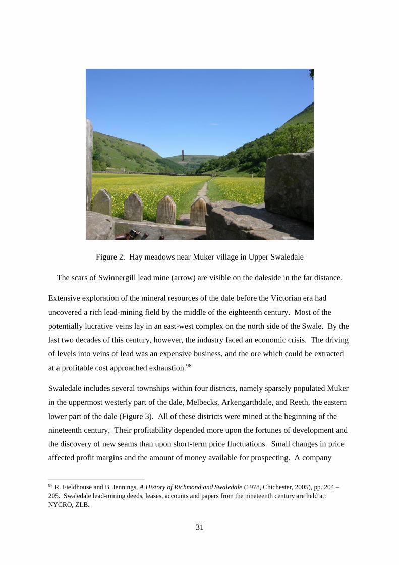
31
Figure 2. Hay meadows near Muker village in Upper Swaledale
The scars of Swinnergill lead mine (arrow) are visible on the daleside in the far distance.
Extensive exploration of the mineral resources of the dale before the Victorian era had
uncovered a rich lead-mining field by the middle of the eighteenth century. Most of the
potentially lucrative veins lay in an east-west complex on the north side of the Swale. By the
last two decades of this century, however, the industry faced an economic crisis. The driving
of levels into veins of lead was an expensive business, and the ore which could be extracted
at a profitable cost approached exhaustion.98
Swaledale includes several townships within four districts, namely sparsely populated Muker
in the uppermost westerly part of the dale, Melbecks, Arkengarthdale, and Reeth, the eastern
lower part of the dale (Figure 3). All of these districts were mined at the beginning of the
nineteenth century. Their profitability depended more upon the fortunes of development and
the discovery of new seams than upon short-term price fluctuations. Small changes in price
affected profit margins and the amount of money available for prospecting. A company
98 R. Fieldhouse and B. Jennings, A History of Richmond and Swaledale (1978, Chichester, 2005), pp. 204 –
205. Swaledale lead-mining deeds, leases, accounts and papers from the nineteenth century are held at:
NYCRO, ZLB.

32
fortunate enough to find a rich deposit of ore could make a profit even with lead at a low
price, but a high price would not ensure prosperity if the workings were meagre. Output and
profits varied from year to year.
Prices of lead rose towards the end of the Napoleonic Wars in 1815, fell in a post-war
depression, but recovered thereafter to reach a peak in 1825. However, all the lead-mining
areas of Britain suffered a prolonged depression beginning with the general trade slump of
1826. Trade recovered in the dale in 1827, but the price of lead continued to fall. A major
cause of the decline was competition in the market from lead exported from Spain. The
depression lifted to an extent in the 1830s in the Swaledale mines when they were managed
effectively by a small group of local investors. However, the terminal collapse of the
industry set in when the main seams of lead in the major mines became exhausted in the late
1870s. The demise was a slow process, picking off districts and townships selectively. The
mines in Muker failed early, the Old Gang mine in Melbecks between 1871 and 1891, and the
Arkengarthdale mines between 1881 and 1901. The mines were finally abandoned at the
outbreak of the Great War in 1914.99
99 A. Raistrick, Mines and Miners of Swaledale (Clapham, 1955); Fieldhouse and Jennings, History of Richmond
and Swaledale, pp. 218 – 219 & 226 – 228. British exports of lead averaged 18,000 tons a year in the years
1816-20. They fell to about 10,000 tons a year in 1829-33. Lead production in Spain and other countries had
increased significantly by the late 1870s. From being the world’s largest producer of lead in the 1820s, Britain
by 1880 imported nearly twice as much lead as was mined at home.

33
Figure 3. The four districts, villages and River Swale in Upper Swaledale
(Redrawn from the OS map of Swaledale 1856-7, original magnification six-inch to the mile
(1:10,560))
The population of Swaledale enjoyed rapid growth in the early decades of the nineteenth
century, reaching a peak in 1821 (Figure 4). By 1911 Swaledale had lost two thirds of its
population since this summit almost a century before.100 The strength of the dale’s
agricultural base enabled the economy to survive this industrial and demographic collapse.
Landholding in Swaledale in the nineteenth century was not dominated by large estates or
aristocratic control.101 There was agricultural self-sufficiency and a buoyant non-agricultural
workforce such that local demand for both owning and renting small plots of land was high.
Competition for the limited proportion of cultivated land in this upland landscape remained
100 C. Hallas, Rural Responses to Industrialization: The North Yorkshire Pennines 1790-1914 (Bern, 1999), pp.
16 – 50.
101C.S. Hallas, ‘Yeomen and peasants? Landownership patterns in the North Yorkshire Pennines, c. 1770 –
1900’, Rural History, 9 (1998), p. 157.

34
strong even after the collapse of the lead industry. Open field farming had virtually
disappeared from Swaledale by the seventeenth century, and arable farming was almost non-
existent in the upper dale in the 1800s. There were only about 120 acres of ploughing in
Swaledale above Grinton during the 1820s and 200 acres in Grinton parish in 1840, most of
which was at Reeth.102 The predominant category of landowner in the nineteenth century
was the lesser yeoman and small proprietor.103 Many owners of medium-sized estates, while
occupying part of their land, also let some of their holding at relatively high rents and
engaged in other activities such as lead mining or the textile industry.
In the mid-nineteenth century 25.1% of the occupied population of Swaledale owned some
land but this proportion had fallen to 9.6% by the 1870s.104 The changing status or
occupations of individuals are noted in the censuses and directories.105 Many yeomen had a
diversity of activities including lead and coal mining. Similarly where the lead industry
predominated small owner-occupied holdings were popular as a secondary source of income
and as a buffer against hard times in the mining industry. As miners sold their plots of land
and left the dale, small yeomen were able to expand their holdings. As lead mining went into
decline and demand for land from dual-occupation lead miners fell, the overall number of
small owned holdings also fell. The pattern of landholding was complicated further by the
practice of primogeniture which had become the dominant mode of inheritance by the
nineteenth century.106 Inheritors of small subdivided holdings could be constrained to sell
their apportionment, encouraging the consolidation of ownership to holdings of moderate size
of widely dispersed lands.
102 M. Hartley and J. Ingilby, Life and Tradition in the Yorkshire Dales (London, 1968); Fieldhouse and
Jennings, History of Richmond and Swaledale, p. 466.
103 Owners in 1873 in this category held 73% of Swaledale excluding common land (Hallas, ‘Yeomen and
peasants?’ p. 160); common land comprised at least 60% of the total area (W.G. Hoskins and L.D. Stamp, The
Common Land of England and Wales (London, 1963), pp. 340 – 341).
104 Hallas, ‘Yeomen and peasants?’, p. 165.
105 The census enumerators in Swaledale recorded these household heads as ‘farmer’, ‘lead miner’ and ‘lead
miner and farmer’, and these descriptions have been used in the tables and figures for specific individuals in this
study. Householders and enumerators were instructed to list occupations in order of importance, the Census
Report claiming that the ‘first occupation was generally taken’ (P.M. Tillot, ‘Sources of inaccuracy in the 1851
and 1861 censuses’, in E.A. Wrigley (ed.), Nineteenth-century Society: Essays in the Use of Quantitative
Methods for the Study of Social Data (Cambridge, 1972), p. 117).
106 Hallas, ‘Yeomen and peasants?’, pp. 161 – 162.

35
Owner-occupiers of land showed a high degree of resilience in confronting the initial impact
of the late nineteenth-century depression. Small owners were particularly vulnerable,
however, and as the population declined and the impact of national agricultural depression
took effect they sold their holdings.107 In the depths of the 1890s depression proportionally
more dalesmen were farming the land they owned, but the protracted nature of the depression
eventually took its toll. Increasing numbers of owner-occupiers were obliged to sell their
land so that by 1917 the proportion of dalesmen renting their holdings exceeded a previous
peak of 1887.108
Figure 4. Population of Swaledale during the nineteenth century
The population trends in Swaledale reflect the dale's reliance upon the lead mining
industry.109 In the early years of the nineteenth century, the greatest growth in population
occurred in townships with a substantial lead industry; similarly, the most severe losses in the
second half of the century occurred in those townships where the lead industry had been most
107 Hallas, ‘Yeomen and peasants?’, pp. 161 – 168.
108 Proportion of dalesmen renting their holdings in 1915 = 96.6; in 1887 = 93.7; Table 6 in Hallas, ‘Yeomen
and peasants?’, p. 168.
109 See ‘Lead mining in Swaledale since 1540’, in Fieldhouse and Jennings, History of Richmond and
Swaledale, pp. 204 – 231.
2000
3000
4000
5000
6000
7000
8000
To
tal P
opula
tio
n
Year
36
influential. The population changes thus varied considerably between townships. The entire
dale suffered severe difficulties following the near total collapse of its lead industry towards
the end of the nineteenth century, when a large proportion of the population left the dale.
The dale experienced considerable ebbs and flows of migration over the course of the
nineteenth century. The Melbecks and Arkengarthdale regions experienced a considerable
influx of migrants at the end of the eighteenth century and in the first decade of the
nineteenth. In Arkengarthdale the population increase is attributed to an influx of
mineworkers from the agricultural districts of the North Riding and South Durham. Those
miners who were already established when the migrants arrived retained their smallholding.
However, most of the migrants were unable to rent a holding of land. The population growth
caused poor relief expenditure to rise, particularly when there was a slump in the mines for
any reason.110 More than half the paupers in Reeth in 1817 were migrant miners. The
pressures felt by lead-mining parishes were aggravated by the decision taken in 1816 to
exempt the lead mines from poor rates. The mine owners were able to avoid this liability to
pay rates until 1874, throwing the burden onto the occupiers of land. Poor miners with a dual
occupation on the land then subsidised their inadequate earnings at the mines from the rates
they had contributed from their smallholdings.
Out-migration from the Yorkshire mines in the economic depression of the 1820s was
predominantly to the textile or mixed textile coal districts of Lancashire and the West Riding
of Yorkshire.111 The poorest families generally could not raise enough capital to leave, and
early migrants were from the farming classes rather than labourers. Some families emigrated
to the United States or Canada, with a further wave of emigration in the early 1840s to North
America.112 Waves of migration occurred particularly in the 1830s, 1840s, 1870s and 1880s,
110 See ‘Parish relief’ and ‘Poor law unions’, in Fieldhouse and Jennings, History of Richmond and Swaledale,
pp. 289 – 316.
111 The social conditions and population movements in the mining areas in decline are described in: Raistrick
and Jennings, A History of Lead Mining, pp. 324 – 327. The first farmers and tradesmen to emigrate to America
in the late 1820s and 1830s were men with capital released by the sale of farms (Richards, ‘Malthus’, p. 53).
Morris suggests that recent arrivals to the dales without mining or farming work were the first to migrate to the
mills of Lancashire or South Yorkshire or the coalfields from about 1830 (D. Morris, The Dalesmen of the
Mississippi River (York, 1989), p.2.). See also M. Hartley and J. Ingilby, Dales Memories (Clapham, 1986).
112 See C.J. Erickson, ‘Emigration from the British Isles to the U.S.A. in 1841: Part I. Emigration from the
British Isles’, Population Studies, 43 (1989), p. 347, and C.J. Erickson, ‘Emigration from the British Isles to the
U.S.A. in 1841: Part II. Who were the English emigrants’, Population Studies, 44 (1990), p. 21.

37
this final decade accounting for more than a third of the total migration from Wensleydale
and Swaledale.113 Lead miners were the most mobile section of the population.114
Sometimes parishes offered financial encouragement to their poor to emigrate.115 On the
other hand, parishes may have found themselves liable for relieving paupers who had
emigrated but had not been accepted in their adopted residence. Of 77 adults receiving
pensions from Muker in 1835, for example, only 33 lived in the township: 18 others lived
elsewhere in the dale and 18 in the industrial towns of the West Riding of Yorkshire and
Lancashire. In the same parish of Muker inhabitants agreed not to sell land to immigrants,
thus preventing them from obtaining legal settlement and an entitlement to relief. The
emigrant families of the later depression towards the end of the century left for the same areas
as their predecessors in general, namely to East Lancashire and the industrial West Riding.
The Burnley area of Lancashire attracted a substantial influx, with work in the coal mines and
textile mills. A smaller proportion of the migrants emigrated abroad, on this occasion to
Australia as well as North America.116
Numerous dales yeomen families persisted and survived throughout this century. Many were
anxious to remain in the dale even when this was not their best chance of survival. They drew
increasingly during this period on members of their family to provide the agricultural
workforce.117 The declining population lived off larger plots of land during the lead
industry’s demise. Many deserted farms and cottages, most of late eighteenth or nineteenth
century origin, today lie high on the daleside as reminders of an era long gone. Lead mining
in this community has now disappeared, and so too almost has the small family farm.
*
113 Hallas, Rural Responses to Industrialization, p. 274 and 292. Migration to Lancashire also increased in the
1890s as the local economy there boomed; see W.H. Long and G.M. Davies, Farm Life in a Yorkshire Dale
(Clapham, 1948).
114 C.S. Hallas, ‘Migration in nineteenth-century Wensleydale and Swaledale’, Northern History, 27 (1991), p.
153 – 155.
115 See G. Howells, ‘“For I was tired of England sir”: English pauper emigrant strategies, 1834 – 1860’, Social
History, 23 (1998), p. 181.
116 NYCRO, ZRD: Muker select vestry and overseers account book 1797 – 1840, Muker select vestry minutes
1819 – 1837; Fieldhouse and Jennings, History of Richmond and Swaledale, pp. 301 – 303.
117 Hallas, Rural Responses to Industrialization, pp. 26, 71 and 294; Richards, ‘Malthus’, p. 58.

38
This Introduction has attempted to place rural and urban kinship families in historical context
and to consider some migrations into York and out of Swaledale. Chapter 2 describes a novel
method of quantifying, tracking and comparing these families.

39
Chapter 2
Surname Indices: Concept and Application
‘… you know, there is no such thing as society. There are individual men and women, and
there are families.’1
Measurements of Kinship
A substantial body of literature links the study of surnames with the history of the family and
population change. All methods of measuring surname density and drawing inferences about
migration have their sampling problems and particular disadvantages. This thesis adds to the
debate with a novel method of exploiting surname densities that is then used to address the
research questions posed in the Introduction.
Many studies aim to address the stability of populations and the identity, behaviour and
divisions of villages, towns, parishes or regions by examining the distribution and density of
individuals with the same surname in the populations.2 Lasker and others have attempted to
measure the degree of ‘biological’ or genetic kinship between and within communities
subject to past migrations by estimating the frequencies of individuals with shared surnames.3
1 Margaret Thatcher, former British Prime Minister, talking to Women's Own magazine, 31.10.1987.
2 G. Redmonds, T. King and D. Hey, Surnames, DNA, and Family History (Oxford, 2011); S. and D. Postles,
‘Surnames and stability: a detailed case study’, in D. Hooke and D. Postles (eds), Names, Time and Place.
Essays in Memory of Richard McKinley (Oxford, 2003), p.193; G. Lasker, ‘Using surnames to analyse
population structure’, in D. Postles (ed.), Naming, Society and Regional Identity (Oxford, 2002), p. 5; K.
Schürer, ‘Surnames and the search for regions’, Local Population Studies, 72 (2004), p. 50; D. Hey, ‘The local
history of family names’, The Local Historian, 27 (1997), p. i; R. Watson, ‘A study of surname distribution in a
group of Cambridgeshire parishes 1538 – 1840’, Local Population Studies, 15 (1975), p. 23; K.D.M. Snell,
‘English rural societies and geographic marital endogamy, 1700 – 1837’, Economic History Review, 55 (2002),
p. 262; D.S. Smith, ‘“All in some degree related to each other”: A demographic and comparative resolution of
the anomaly of New England kinship’, The American Historical Review, 94 (1989), p. 44. See also E.A.
Wrigley, Population and History (1969, London, 1973); and D.E.C. Eversley, P. Laslett and E.A. Wrigley, An
Introduction to English Historical Demography: From the Sixteenth to the Nineteenth Century (London, 1966).
3 G.W. Lasker, ‘A coefficient of relationship by isonymy: a method for estimating the genetic relationship
between populations’, Human Biology, 49 (1977), p. 489; J.H. Relethford, ‘Estimation of kinship and genetic
distance from surnames’, Human Biology , 60 (1988), p. 475; D. Souden and G. Lasker, ‘Biological inter-
relationships between parishes in East Kent: An analysis of marriage duty act returns for 1705’, Local
Population Studies, 21 (1978), p. 30; Küchemann, G.W. Lasker and D.I.Smith, ‘Historical changes in the
coefficient or relationship by isonymy among the populations of the Otmoor villages’, Human Biology, 51
(1979), p. 63; G.W. Lasker, ‘Evidence from surnames on the population structure of villages surrounding the
Otmoor’, in G.A. Harrison (ed.), The Human Biology of the English Village (Oxford, 1995), p. 137; M.T. Smith
and B.L. Hudson, ‘Isonymic relationships in the parish of Fylingdales, North Yorkshire in 1851’, Annals of
Human Biology, 11 (1984), p. 141; M.T. Smith, B.L. Smith and W.R. Williams, ‘Changing isonymic

40
Smith and colleagues have developed the concept of random isonymy, by which a score
obtained by multiplying the relative frequency of every surname in one population by the
relative frequency of the same surname in another population quantifies the surname
distributions between the two.4 A map subsequently generated by a statistical technique,
non-metrical multidimensional scaling, visualises the geographical distribution of surnames.
Other authors including Anderson have looked at ‘functional’ or ‘behavioural’ kinship within
a community with an analysis of the frequency of people with the same surname.5 Another
analytical line of enquiry into kin relations, the technique of micro-simulation, although
diverting from the situation in real historical communities or named individuals, uses the
rates of fertility, nuptiality and mortality in a population to estimate the number of kin a
person would possess during different stages of the life cycle.6
Many of the studies of kin outlined above have developed from an analysis of individuals in a
population with the same surname. These enquiries permit exploration of kinship ties after
the identification of individuals. The concept of surname indices developed in this thesis,
however, departs from this approach. The indices measure not the density of people, but the
density of surnames. They identify a subgroup of kin, i.e. those with the same surname,
before the identification of the individuals, whose connections are then explored with
reference to the censuses and family reconstitution techniques once the numerical analysis of
relationships in Fylingdales parish, North Yorkshire, 1841 – 1881’, Annals of Human Biology, 11 (1984), p.
449; M. Smith, ‘The inference of genetic structure and the micro-evolutionary process from the distribution and
changing pattern of surnames’, in D. Postles (ed.), Naming, Society and Regional Identity (Oxford, 2002), p. 25.
4 M.T. Smith and D.M. MacRaild, ‘Nineteenth-century population structure of Ireland and of the Irish in
England and Wales: an analysis by isonymy’, American Journal of Human Biology, 21 (2009), p. 283; M. Smith
and D.M. MacRaild, ‘The origins of the Irish in Northern England: an isonymic analysis of data from the 1881
census’, Immigrants & Minorities, 27 (2009), p. 152.
5 M. Anderson, Family Structure in Nineteenth Century Lancashire (Cambridge, 1971), p. 61. Anderson’s
labour-intensive method of finding kin by trawling through surnames in census data suffers from serious
disadvantages, not least the difficulty in covering the whole population and the lack of specificity in birthplaces.
See also A. Plakans, ‘Kinship’, in P.N. Stearns (ed.), Encyclopedia of European Social History from 1350 to
2000 (New York, 2001), p. 101 for a discussion of approaches to measurement and meaning of kinship.
6 R. Wall, ‘Economic collaboration of family members within and beyond households in English society, 1600 –
2000’, Continuity and Change, 25 (2010), p. 95; Z. Zhao, ‘The demographic transition in Victorian England in
English kinship networks’, Continuity and Change, 11 (1996), p. 243; M. Murphy, ‘Changes in family and
kinship networks consequent on the demographic transitions in England and Wales’, Continuity and Change, 25
(2010), p. 109; J.E. Smith and J.E. Oeppen, ‘Estimating numbers of kin in historical England using demographic
microsimulation’, in D. Reher and R.S. Schofield (eds), Old and New Methods in Historical Demography
(Oxford, 1993), p. 280.

41
the whole population has been completed. Errors that may be introduced into a study by the
failure to identify specific individuals in a population before an analysis is undertaken are
thus avoided. The indices cannot be interpreted with any degree of accuracy without
reference to the size and number of groups of people with the same surname from which the
indices have been derived. Referral back to the listings of all these individuals in the
transcripts from which they have been taken minimises the theoretical risks of misinterpreting
the number or sizes of kinship families at each data point in the surname indices.7 This
method allows the measurement of the size of possible kin groups at different or consecutive
points in historical time in the same population, and comparisons between different
populations. How these indices changed over time or varied between groups of people can
provide unforeseen insights into communal motivations and behaviour.
Concept of Surname Indices
This chapter explains the new concept and idea, and goes on to illustrate the method by
relating changes in surname and family density to an historical event through family
reconstitution methods in two rural parishes near York. The limitations and disadvantages of
the technique are described in detail. Kinship families in this context indicate households in a
community led by people with the same surname, generated by descent or marriage. In
contrast isolated families refer to those households headed by an individual with a surname
unique in the neighbourhood. An index is described in which the number of specific
surnames is assessed in relation to the total number of individuals in the population. A
population with a small number of surnames relative to its size contains a relatively large
family or a large number of isonymic families (families with the same surname); by contrast,
a population with a large number of surnames relative to its size may contain relatively few
kin networks. As an extreme hypothetical example, if there is only one surname in a
population of 100 individuals, it is probable that all these individuals belong to one kinship
family (a low index); if, on the other hand, there are 100 surnames in this population, then
there are present 100 isolated but no kinship families (a high index). The lower the index, the
lower is the density of isolated surnames; or the larger is the size or number of probable kin
groups. The higher the index, the greater is the concentration of isolated families with few
7 Surname indices are thus applicable only to micro-historical studies. Cheshire discussed the difficulty of
interpreting the relative number of surnames per head of population without knowledge of the frequency
distribution of surnames: J.A. Cheshire, ‘Surnames Diversity’, in ‘Population Structure and the Spatial Analysis
of Surnames’ (unpub. PhD thesis, UCL Department of Geography, 2011), pp. 82 – 84.

42
kin networks. This index was used to provide a means of assessing whether a population
may have harboured a relatively large or small number of kinship families. Over the course
of the nineteenth century, migration into a parish, industrialisation and growth of a more
complex occupational mix would tend to dilute the concentration of surnames in a rural
village and elevate such an index.8
The index was therefore named a ‘surname index’ for each population examined, and was
defined as the number of surnames divided by the size of the population, and the figure
multiplied by 100 in order to avoid presentation as a fraction. The surname index may be
derived from a list of names in any defined population either at a point in time or over a
period of time, the denominator (the number of individuals) varying according to the
population under examination. The index bears no relation to the number of individuals with
a particular surname (in other words, it differs from surname density), and it is not
proportional to the size of the population. A surname index derived from census data gives
the proportion of people with shared surnames in a population, and no inherent information
on the number or sizes of groups of individuals with the same surname; the interpretation of
census surname indices therefore depends on other qualitative information on families
gathered from census enumeration data and family reconstitutions. Indices varying over a
period of time also give no insights into the cause of any change in population size, for
example migration or altered fertility. Examples of lists of people from whom surname
indices may be calculated include the parish population taken from a decennial census,
baptisms recorded in a parish register, and surviving memorials in a graveyard. Such indices
may therefore provide information on different sections of the same community.
Census, Fathers’ and Memorial Surname Indices
This section describes the methods by which surname indices are calculated from people
listed in census enumerators’ books, fathers listed in parish baptismal registers, and people
memorialised on gravestones.
The forename and surname and ages of all the people in these listings are transcribed into
separate fields in a Microsoft Excel spreadsheet. The surnames are then sorted into
8 Smith discusses the application of quantitative studies of surname distributions to historical questions related
to industrial development, land tenure and inheritance, enclosure and epidemic disease in: M. Smith, ‘Isonymy
analysis: The potential for application of quantitative analysis of surname distributions to problems in historical
research’, in M. Smith (ed.), Human Biology and History (London, 2002), p. 112.
43
alphabetical order. Duplicate surnames are removed from this list, and the total number of
surnames in the population is then counted. This is related to the number of people in the
population to derive the surname index. Referral back to the sorted spreadsheet of surnames
of every individual then provides the number and sizes of groups of people sharing the same
surname. These groups of people found at each census are tracked backwards and forwards
at other censuses and reproduced in Appendices in this thesis. The identification of specific
groups of people with the same surname at each data-point in the surname index plots
minimises the risk of misinterpreting changes in surname indices over time or between
populations.
1. Census Surname Indices (CSIs): Isonymic, Kinship and Isolated Families
Census surname indices are measured in a population from the census data for the decennial
census years of 1841 onwards. The surnames in the census are sorted into alphabetical order,
and the number of surnames (ie not the number of individuals with a particular surname) is
measured in relation to the total number of people in the population. Lower surname indices
calculated from such census data imply fewer surnames in the parish and thereby larger or
more numerous potential kinship families. Higher indices imply a more dilute concentration
of surnames and fewer potential kinship families in the study group.
The finding of kinship families in a population, ie several households headed by closely
related people with the same surname, implies the growth or immigration of households from
the same or other generations of the same family. The finding of isolated families, ie
households with a surname unique in the population, implies that the family had not had the
desire or capability of forming more than one household. A falling census surname index
over time thereby suggests the net growth of kinship families, and a rising census surname
index over time implies the net influx of isolated families.
Once census surname indices have been plotted over time in a parish, comparisons in family
dynamics may be made and correlations attempted with historical events such as enclosure of
the fields or mass migration. Comparisons of the size and/or number of isonymic families are
also then possible with other parishes and regions, and with surname indices derived from
other data.

44
CSI derived from census household heads (CSI(H))
This index relates the number of surnames of household heads (HHs) to the total number of
household heads. It is the most sensitive index of potential kinship families in the population
as it is not affected by differences in fertility or the retention of children in households. The
lower the index the greater is the number of families headed by a person with a shared
surname.
CSI derived from adult census population (CSI(A))
This index relates the number of surnames of adults (16 years and older) to the total number
of adults. In comparison with the index derived from household heads, the number of
additional surnames is always lower than the number of additional people, since adults in a
household often share the same surname as the household head. Consequently CSI(A) is
always smaller than CSI(H) from the same population.
CSI derived from total census population (CSI(T))
This index relates the number of surnames of all individuals to the total number of people
(adults and children) in a population. In comparison with the index derived from adults only,
the number of additional surnames of children is always far lower than the number of
additional children, since almost all children in a household share the same surname as an
adult. Consequently CSI(T) is always smaller than CSI(A) in a population.
The ratio of the total number of people in a population (denominator of SI(T)) to the number
of household heads gives the average number of people per household (or mean household
size (MHS)). This definition of household size gives no indication of the relationship of
individuals in the household to the household head.9 The ratio of the number of adults in a
9 MHS as derived from Surname Index calculations cannot therefore be compared with MHS in some other
studies. Schürer quotes Laslett’s definition of household as ‘a head, plus a spouse if present, any co-resident
children and other kin, as well as servants’ and houseful as household ‘plus other residents attached to but not
within the household, namely boarders, lodgers and any visitors’ (K. Schürer, E.M. Garrett, H. Jaadla and A.
Reid, ‘Household and family structure in England and Wales, 1851 – 1911: continuities and change’, Continuity
and Change, 33 (2018), p. 370). Household in this thesis may correspond therefore with houseful in other
studies. The definition corresponds with the meaning of a ‘family’ as used in the 1851 census as ‘the persons
under one head; who is the occupier of the house, … while the other members of the family are, the wife,
children, servants, relatives, visitors, and persons constantly or accidentally in the house’ (Wall, ‘Economic
collaboration of family members’, p. 83). Ruggles defines a family as any group of related people who reside
together (S. Ruggles, Prolonged Connections: The Rise of the Extended Family in Nineteenth Century England
and America (Madison, 1987), p. 11.

45
population (denominator of SI(A)) to the number of household heads (denominator of SI(H))
gives the average number of adults per household (A/H). The difference between the total
number of people and the total number of adults gives the total number of children in a
population. The ratio of the total number of children to the number of household heads gives
the average number of children per household (CPH).
CSI derived from cohorts of the census population (CSI(C))
This index relates the number of surnames of people identified from a census in a specific age
range (or cohort) to the total number of people in that sample.
An index derived from a young age cohort (children) tends to be low because siblings share
the same surname in each nuclear family; an index derived from an old age cohort tends to be
high because mortality reduces the number of people with shared surnames.
2. Fathers’ Surname Indices (FSIs): Fertile Kinship Families
Fathers’ surname indices are derived from the number of surnames of fathers relative to the
number of fathers in the parish registers over a period of time. The names of all children are
taken from the register, children without a paternal surname are omitted, the surnames are
sorted into alphabetical order, and the number of surnames (ie not the number of individuals
with a particular surname) is measured in relation to the total number of fathers (identified by
forename and surname) (Fathers surname index (FSI) = (Number of surnames of
fathers/Number of fathers) x 100). A rising or relatively high FSI implies a larger number of
fathers’ surnames, and fewer isonymic fertile men in the parish (and vice versa). The data are
calculated in a moving 20-year cycle.
A rising number of fathers in a population over a period of time with a falling FSI implies
progressively more numerous fertile isonymic men, and with a rising FSI a progressive
increase in the number of isolated (or non-kinship) fertile men in the population. A falling
number of fathers over time with a falling FSI, on the other hand, implies that residual fertile
men were drawn from an increasing number or size of isonymic groups, while a rising FSI
with decreasing number of fathers suggests that residual fertile men increasingly came from
isolated families.
The ratio of the number of baptisms to the number of fathers over a period of time gives a
measure of the average number of children fathered by one man. This number bears no
46
relation to the crude birth rate, or the ratio of the number of births to the entire population in a
year.10
Surname indices derived from census data (CSIs) and those derived from baptismal registers
(FSIs) are thus drawn from different population groups but have similar implications. The
census surname index relates the number of surnames of people to the size of the population
at a point in time. The fewer is the number of surnames (and the lower the index), the more
likely it is that people of the same surname form discrete kin-related households or families
in the community. Fathers’ surname indices, on the other hand, relate the number of
surnames of fathers in a community to the number of fathers over a period of time. The
smaller the number of surnames of fathers relative to the number of fathers (and the smaller
the index), the more likely it is that some of these men were related kin. Thus census
surname indices describe the population at a fixed point; the fathers’ surname indices
describe a subgroup of the adult population, namely married fertile men over a period of
time. A low census or fathers’ surname index implies more potential kinship families.
Comparison of census and fathers’ surname indices over a period of time in a parish may give
insights into the behaviour of these families.
3. Memorial Surname Indices (MSIs): Family visibility
A survey of parish church and chapel iconography and the distribution and memorialisation
of gravestones of the villagers provides important evidence on the status of families and
landowners in the community.11 A surname index of the surviving memorials in a graveyard
may be calculated, in which the enumerator is the total number of surnames recorded in the
memorial inscriptions, and the denominator the total number of people memorialised. A high
surname index in this context implies the memorialisation of a large number of isolated
families from the parish, whereas a lower index implies the memorialisation of more
individuals from relatively fewer families. The parishioners saw a visible reminder of large
or kinship families of elevated standing (or core families) in a graveyard with a low surname
index.
10 See M. Drake, ‘Rates and Ratios’, in M. Drake and R. Finnegan (eds), Sources and Methods for Family and
Community Historians: A Handbook (Cambridge, 1994), p. 182.
11 K.D.M. Snell, ‘Gravestones, belonging and local attachment in England’, Past & Present, 179 (2003), p. 97.

47
Surname indices: Assumptions and Flaws in the Methodology
The surname indices used in this thesis are defined as follows: Census surname index (CSI) =
(Number of surnames of enumerated people/Number of people) x 100; Fathers’ surname
index (FSI) = (Number of surnames of fathers/Number of fathers) x 100; Memorial surname
index (MSI) = (Number of surnames recorded on gravestones/Number of people
memorialised) x 100. Subgroups of CSIs are those derived from household heads only
(CSI(H)), adults only (CSI(A)), total population (CSI(T)), and age cohorts (CSI(C)).
These indices provide no more than a number which can be used to compare populations.
They provide no information about specific families.
There are three significant flaws in the methodology, which may become apparent when
changes in the index are viewed alongside reconstituted families.12
1. Isonymic and Kinship Families
Any surname index measures the concentration of people with the same surname, ie isonymic
people. Kinship family members by the definition used in this thesis are isonymic, but not all
isonymic people may be related by kinship.13 Kinship implies a broader concept even than
individuals resident in a household and related individuals resident elsewhere. Kin may be
conceptualised as a ‘wide range of relations, half-relations, and relations-in-law, and also
non-related individuals’, bound together by a ‘series of contractual, occupational and
affective relationships’.14 This caveat applies particularly to people with a common surname,
eg Smith in an English population or Kelly in an Irish population. Notions of the meaning
and significance of kinship bonds have changed radically over historical time.15 This thesis
12 Some implications of different definitions of household and kin are discussed in Schürer, Garrett, Jaadla and
Reid, ‘Household and family structure’, p. 365.
13 Lasker maintained that people with the same surname can be assumed ultimately to be members of the same
lineage, since lines of descent disappear over time so that the remaining individuals are increasingly likely to be
related: Lasker, ‘Using surnames’, p. 5. This view, however, is an oversimplification; see Redmonds, King and
Hey, Surnames.
14 N. Tadmor, ‘Early modern English kinship in the long run: reflections on continuity and change’, Continuity
and Change, 25 (2010), pp. 24 and 31.
15 N. Tadmor, Family and Friends in Eighteenth-Century England: Household, Kinship and Patronage
(Cambridge, 2000); P.P Schweitzer (ed.), Dividends of Kinship: Means and Uses of Social Relatedness
(London, 2000); M. Segalen, Historical Anthropology of the Family, Cambridge, 1986); K.D.M. Snell, Spirits
of Community: English Senses of Belonging and Loss, 1750-2000 (London, 2016), pp. 241-245.

48
assumes that isonymic people are kin in small rural parishes and in regions with a high rate of
endogamy (such as Swaledale), but not necessarily so in urban communities that attract
incomers.16
The definition of kinship in this thesis is numeric and narrow, and excludes many family
members and associates in a community who were regarded as kin. Surname indices notably
exclude affinal kin members who have changed surname by marriage as well as others related
through marriage. Surnames which are phonetically similar or which vary by a single letter
(eg Brannan, Brannon, Brannen and Brenan) in this work are regarded as the same name.
The age at which children became adults was arbitrarily chosen as 16 years in this study,
based upon the approximate age throughout the nineteenth century at which Pooley and
Turnbull estimate the rate of migration of children to begin to change into the adult pattern.17
2. Sample Sizes
The larger the discrepancy between the number of surnames and the number of individuals in
a population, the less is the change in surname index for the addition (or subtraction) of a
given number of surnames. In other words, the addition of one surname to a population of
(say) 100 people produces a smaller change in surname index than if there had been only 50
people in the population. A worked example of this issue appears in this chapter.
3. Selected Populations
The recording of surnames in populations is often incomplete, and this applies uniformly with
memorial inscriptions on gravestones. The number of gravestones standing in churchyards
may be insignificant in comparison with the number of burials. Surnames may be illegible on
16 A high rate of endogamy existed also in parts of Wales, where Rees went so far as to claim that ‘every
household is bound to every other by kinship ties, …’, many neighbours sharing the same surname. Rees quotes
a saying that the neighbourhood was like a dog: ‘If you tread on its tail at one end of the valley, it will bark at
the other end’. In this valley the emotional significance of kinship ‘pervaded everything’ (A.D. Rees, Life in a
Welsh Countryside: A Social Study of Llanfihangel yng Ngwynfa (Cardiff, 1951), p. 75 – 77 & 80). Similarly in
Gosforth, Cumberland, there were families in the twentieth century that had lived in the same place for in excess
of four centuries (W.M. Williams, The Sociology of an English Village: Gosforth (London, 1956), p. 2).
17 C. Pooley and J. Turnbull, Migration and Mobility in Britain since the Eighteenth Century (London, 1998), p.
207. This approximation has been challenged in K. Schürer, ‘Leaving home in England and Wales, 1850 –
1920’, in J. Lee, M. Oris and F. van Poppel (eds), The Road to Independence: Leaving Home in Western and
Eastern Societies, 16th – 20th Centuries (Oxford, 2004), p. 33; and J. Day, ‘Leaving Home and Migrating in
Nineteenth-Century England and Wales: Evidence from the 1881 Census Enumerators’ Books (CEBs)’ (unpub.
PhD. Thesis, University of Cambridge, 2015).

49
surviving gravestones. The parishioners willing and able to erect lasting gravestones are also
self-selected by wealth and social standing in the community. Memorials are therefore class
specific. The deceased memorialised on tablets and tombs within churches are more highly
selected by the parish elite and therefore excluded from analysis, as are names remembered
on war memorials.
However, there exists a growing historiography of graveyard and gravestone studies, which
have arrived at consistent reproducible conclusions from a variety of churches and
approaches.18 The loss of names and gravestones in any churchyard is also a random process
dictated largely by natural deterioration and little active human intervention, and there is no
reason to suppose that legible tombstones erected over a period of time are not representative
of all the parishioners who had stones inscribed. Memorial surname indices may reveal the
effects of migration, the nature of local elites, or the entry of lower status people in the parish.
Baptismal parish registers also are occasionally incomplete. Years for which no registers are
available are excluded from the calculation of Fathers’ Surname Indices, as are years for
which the number of entries is not broadly similar to the numbers in adjacent years.
4. Summary critique of the Surname Index formulated following viva discussion with
examiners
The Surname Index employed in this thesis is a measure of surname diversity within a
population or sample, calculated as (number of surnames in population)/(number of
individuals in population), multiplied by 100 to yield an integer or percentage rather than a
fraction. This measure has been demonstrated and critiqued by James Cheshire in his 2011
PhD thesis, and whilst it can be effective (though not infallible), for example in
demonstrating increased surname diversity in cities, which tend to be migration sinks, it can
be very hard to interpret in other contexts. The reasons for this limitation of the surname
index are as follows:
18 Snell, ‘Gravestones’, Figures 1 - 3; C. Rawding, ‘The iconography of churches: a case study of landownership
and power in nineteenth-century Lincolnshire’, Journal of Historical Geography, 16 (1990), p. 157; K.D.M.
Snell, Parish and Belonging: Community, Identity and Welfare in England and Wales 1700 – 1950 (Cambridge,
2006), pp. 454 – 495; S. Tarlow, Bereavement and Commemoration: An Archaeology of Mortality (Oxford,
1999); H. Lees, English Churchyard Memorials (Stroud, 2000); H. Mytum, Recording and Analysing
Graveyards (York, 2000); K.D.M. Snell and R. Jones, ‘Churchyard memorials: ‘Dispensing with God
gradually’: Rustication, decline of the Gothic and the emergence of Art Deco in the British Isles’, Rural History,
29 (2018), p. 45.

50
1) Because the number of repetitions of each surname is not preserved in the index, the index
gives no insight into family structure and kinship. For example, a population of 100 people
with a surname index of 50 could comprise 50 different surnames each held by 2 people, or
51 people with one surname and 49 people with unique surnames; the index itself does not
tell us which of these or of any other possibilities is actually the case. Thus, in general, we
cannot infer that two populations with the same surname index have the same kinship
structure. 2) Because individual surnames are not preserved in the index, the index is
inappropriate for tracking change or stability through time in population structure. From
census decade to decade, for example, new surnames might enter the population, old
surnames leave, and – as an extreme hypothetical example – the index itself will not tell us
even if all the surnames observed in one decade have been replaced by new ones in the next.
3) The surname index is very sensitive to population and sample size, and this has probably
played an important role in shaping the results of the analyses conducted.
Because of these limitations, whilst the index may sometimes produce results that appear
consistent with inference from conventional approaches, it can never be relied upon to do so.
For that reason, inference from the statistic itself must be discounted in the following
passages of the thesis:
Chapter 2 Surname Indices: Concept and Application pp. 39-70; p.56, Fig. 8, p. 57, Fig. 9, p.
58, Fig. 10, p. 60, Figs. 11, 12, p. 63, Fig. 13.
Chapter 3 York pp. 71-107; Holgate p. 73, Figs. 19, 20, p. 74, Figs. 21, 22; Walmgate p. 93,
Figs. 31, 32, p. 94, Figs. 33, 34, p. 95, Fig. 35.
Chapter 4 Swaledale pp. 108-144; p. 109, Fig. 44, p. 111, Figs. 45, 46, p. 112, Figs. 47, 48, p.
116, Fig. 54, p. 117, Figs. 55, 56, p. 118, Fig. 57, p. 142, Figs. 76,77, p. 143, Fig. 78.
Chapter 7 Rural and Urban Comparisons pp. 228-241; p. 229, Figs 86, 87.
Surname Indices: The effects of parliamentary enclosure of the fields on kinship
families during the nineteenth century
This chapter turns now to an example of how surname indices can be exploited to provide
insights on how kinship families may have been affected by an historical event in their
community, in this example enclosure of the village fields. The enclosure movement had a
profound influence on rural society in many ways, including family survival. Of fundamental
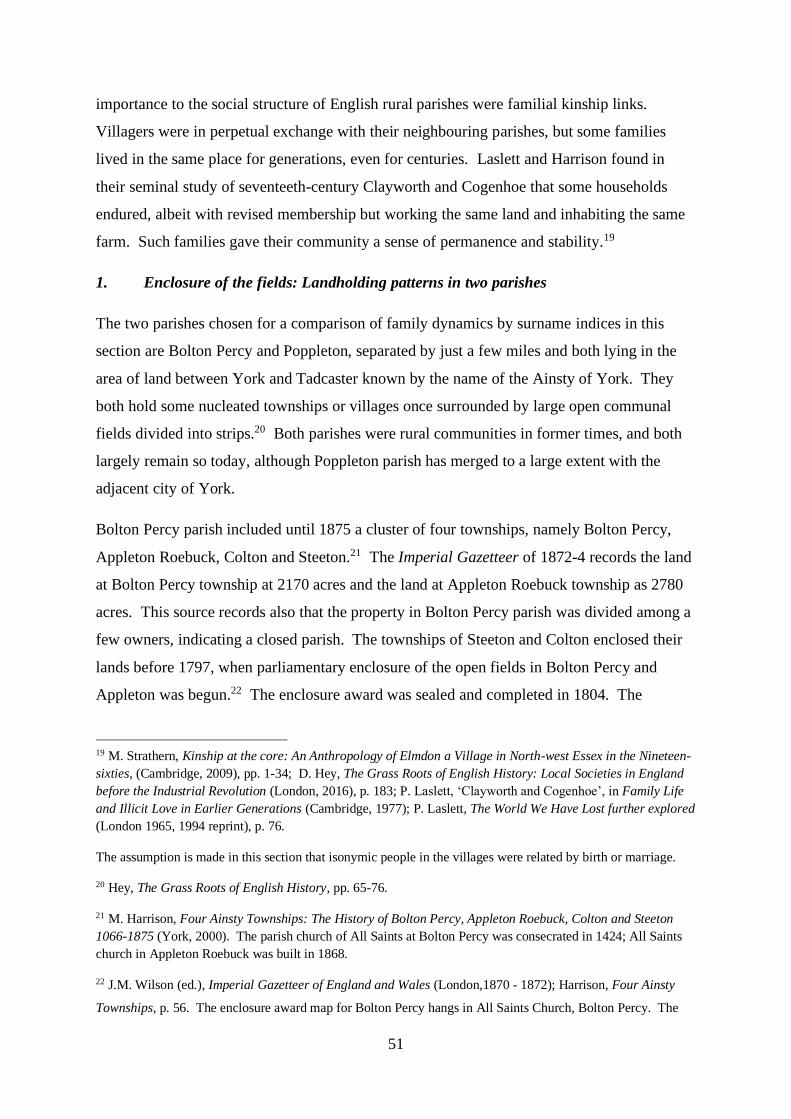
51
importance to the social structure of English rural parishes were familial kinship links.
Villagers were in perpetual exchange with their neighbouring parishes, but some families
lived in the same place for generations, even for centuries. Laslett and Harrison found in
their seminal study of seventeeth-century Clayworth and Cogenhoe that some households
endured, albeit with revised membership but working the same land and inhabiting the same
farm. Such families gave their community a sense of permanence and stability.19
1. Enclosure of the fields: Landholding patterns in two parishes
The two parishes chosen for a comparison of family dynamics by surname indices in this
section are Bolton Percy and Poppleton, separated by just a few miles and both lying in the
area of land between York and Tadcaster known by the name of the Ainsty of York. They
both hold some nucleated townships or villages once surrounded by large open communal
fields divided into strips.20 Both parishes were rural communities in former times, and both
largely remain so today, although Poppleton parish has merged to a large extent with the
adjacent city of York.
Bolton Percy parish included until 1875 a cluster of four townships, namely Bolton Percy,
Appleton Roebuck, Colton and Steeton.21 The Imperial Gazetteer of 1872-4 records the land
at Bolton Percy township at 2170 acres and the land at Appleton Roebuck township as 2780
acres. This source records also that the property in Bolton Percy parish was divided among a
few owners, indicating a closed parish. The townships of Steeton and Colton enclosed their
lands before 1797, when parliamentary enclosure of the open fields in Bolton Percy and
Appleton was begun.22 The enclosure award was sealed and completed in 1804. The
19 M. Strathern, Kinship at the core: An Anthropology of Elmdon a Village in North-west Essex in the Nineteen-
sixties, (Cambridge, 2009), pp. 1-34; D. Hey, The Grass Roots of English History: Local Societies in England
before the Industrial Revolution (London, 2016), p. 183; P. Laslett, ‘Clayworth and Cogenhoe’, in Family Life
and Illicit Love in Earlier Generations (Cambridge, 1977); P. Laslett, The World We Have Lost further explored
(London 1965, 1994 reprint), p. 76.
The assumption is made in this section that isonymic people in the villages were related by birth or marriage.
20 Hey, The Grass Roots of English History, pp. 65-76.
21 M. Harrison, Four Ainsty Townships: The History of Bolton Percy, Appleton Roebuck, Colton and Steeton
1066-1875 (York, 2000). The parish church of All Saints at Bolton Percy was consecrated in 1424; All Saints
church in Appleton Roebuck was built in 1868.
22 J.M. Wilson (ed.), Imperial Gazetteer of England and Wales (London,1870 - 1872); Harrison, Four Ainsty
Townships, p. 56. The enclosure award map for Bolton Percy hangs in All Saints Church, Bolton Percy. The

52
principal landowners at the time were Sir William Milner, the lord of the manors of Appleton
and Bolton, Sir Thomas Turner Slingsby, lord of the manor of Woolas in Appleton, and
Frances Cotton who had inherited lands in Appleton. The rector was allocated an allotment
in return for his open fields and ings, one fifth of the remainder of the open fields as
compensation for tithes due, and an annual tithe rent from the rest of the lands valued outside
the open fields. Exchanges of land also took place between Sir William Milner and the
rector, and the rector's allocation at enclosure was a large compact acreage. The township of
Bolton Percy was dominated by the church rather than the squire. The rector was provided
with a very rich living, including a substantial rectory, gatehouse and tithe barn. The absence
of a resident lord of the manor generated ecclesiastical dominance, and consecutive rectors
imposed heavy burdens on the parish in order to enhance the status of themselves and their
church (Figure 5).23 Although the parish of Bolton Percy was dominated by the Anglican
Church, Nonconformism also took root. Methodism grew following enclosure and its
membership increased with population.24 Following parliamentary enclosure of Appleton,
the Milner family of Nun Appleton and large farmers in the township required an expanded
labour force, and the population there outstripped the township of Bolton Percy.
enclosure awards for Bolton Percy and Poppleton are held at the Borthwick Institute for Historical Research,
University of York: PR. BP100 & PR. Pop 1.
23 E. Bogg, Lower Wharfeland: The Old City of York and the Ainsty, the Region of Historic Memories (York,
1904), p. 12.
24 Harrison, Four Ainsty Townships, pp. 52 – 58, 64 – 65 & 121 – 129.

53
Figure 5. Painting of All Saints Church, Bolton Percy
The two townships of Poppleton also comprise mixed but largely arable land considerably
smaller in acreage than the parish of Bolton Percy. Nether Poppleton stands on the River
Ouse, and comprised 1150 acres listed in the Imperial Gazetteer of 1872-4. Upper Poppleton
comprised at that time 1340 acres. The lord of the manor of Poppleton, Richard Wilson at
the time of enclosure, was not a native of Poppleton and lived in a manor house near
Wetherby.25 The Enclosure Act was passed in 1769 in Poppleton, and the land divided six
years later. The living of both townships was a curacy. Nether Poppleton tithes were
abolished by the enclosure award, and as compensation the vicar of Nether Poppleton
received land there. The Anglican chapel at Upper Poppleton in 1857 was united with the
vicarage at St Mary Bishophill Junior in neighbouring York, but in 1891 was replaced by All
Saints Church consolidated with the vicarage of St Everilda’s Church in Nether Poppleton.26
The populations of Bolton Percy and Poppleton townships across the censuses of the
nineteenth century are shown in Figure 6.
25 P. Bebb, Georgian Poppleton (1714-1830) (York, 1994), pp. 6-12.
26 Enclosure awards and Parish records for Poppleton held at the Borthwick Institute for Historical Research,
University of York: PR. Pop 1. The parish church is All Saints Church, Upper Poppleton.

54
Figure 6. Total Population of Bolton Percy and Poppleton townships 1841 to 1901
All four townships in Bolton Percy and Poppleton showed a similar population trend in the
years up to and including the third quarter of the nineteenth century, namely a period of
growth followed by decline into an agricultural depression. Three of the four townships
(Bolton Percy, Appleton Roebuck and Upper Poppleton) then followed the same pattern in
population figures in the last quarter of the century, namely a slump during agricultural
depression and an upturn in the last decade of the century. The population in Nether
Poppleton bucked the trend of its neighbouring township, however, where there was by
contrast a growth in the population during the years of more widespread depression followed
by a downturn towards the turn of the century. The most likely explanation of this boom in
Nether Poppleton in the face of agricultural depression would seem to be a rural specialism
which could flourish despite hard times in farming generally. Market gardening may have
provided this opportunity.
The enclosure of the open fields of Poppleton took place relatively early in the enclosure
movement in 1775, and a quarter of a century or so later in the parish of Bolton Percy. Both
were ‘closed’ communities. The distribution of plot sizes in these two parishes was the same
in one important respect, namely that more than half the land in each was owned by the
gentry, Sir William Mordaunt Milner, Thomas Turner Slingsby and Frances Cotton in Bolton
Percy (85% of the land), and in Poppleton the Lord of the Manor Richard Wilson and
William Thompson of York (53% of the land). A significant difference exists, however,

55
between the enclosures of the two parishes for landed owners below the level of gentry and
clergy, on account of the fact that more landowners were allocated enclosures in Poppleton
than in Bolton Percy in spite of the smaller total acreage available (Figure 7). Because the
gentry and clergy were allocated such a large acreage in the enclosure of Bolton Percy
(indeed, more land than the total acreage of the parish of Poppleton), the larger population of
landed villagers in Poppleton still tended to receive after enclosure a greater allocation of
land than the villagers in Bolton Percy. Landed villagers in Bolton Percy, though fewer in
number, received less land. The map of Bolton Percy, once the enclosure award had been
implemented, showed less residual land occupied by fewer landowners with yet smaller
individual plots than their neighbours in Poppleton. The rector of Bolton Percy also fared
considerably better (although many years later) in the stakes for land than his counterpart the
curate of Nether Poppleton, receiving four times his acreage of land. It would appear from
this look at the figures that enclosure had favoured the gentry and clergy in Bolton Percy, and
the smaller landowner in Poppleton.
Figure 7. Land acreages awarded at enclosure of Bolton Percy and Poppleton parishes
2. Surname Indices of Populations in Bolton Percy and Poppleton
Census Surname Indices: Kinship and Isolated Families
The decennial censuses of 1841 to 1891 for the townships of Bolton Percy and Appleton
Roebuck in the parish of Bolton Percy and the townships of Nether and Upper Poppleton in

56
the parish of Poppleton were retrieved and the surnames of all individuals in the townships
were transcribed. Surname indices for each parish and township were plotted over time.
A detailed look at the trends in surname indices viewed against adult population size in these
two parishes illuminates clear differences (Figure 8).27 The adult population in both parishes
fell after 1850 for a period of time, and then grew. The decline lasted for 20 years longer in
Bolton Percy than in Poppleton. Throughout this turbulent period, the surname index fell in
four of the six decades and kinship families grew in Poppleton; the surname index rose in
five of these decades and isolated families had more success in Bolton Percy.
Figure 8. Adult population size and census surname indices of Bolton Percy and Poppleton
parishes
27 The smallest number of surnames in a parish census population in this study was 122, and the largest was 213.
The smallest parish adult census population was 329, and the largest was 553. The arrival of 2 new isolated
families (say of 8 people with 4 adults) in the smaller population would raise the index by 0.1 (from (122/329) x
100 =37.1 to (124/333) x 100 = 37.2). The arrival of 2 new kinship families (say of 12 people with 4 adults) in
the larger population would raise the index by 0.1 (from (213/553) x 100 = 38.5 to (215/557) x 100 = 38.6). The
differences in surname indices of the sizes seen in Bolton Percy and Poppleton therefore imply significant
differences between and within the two parishes in numbers of surnames and/or population.
30
35
40
45
50
55
60
65
70
75
80
200
250
300
350
400
450
500
550
600
Surn
ame
Index
Adult
Po
pula
tio
n BP Parish
Population
Pn Parish
Population
BP Parish CSI
Pn Parish CSI

57
Figure 9. Adult population size and census surname indices of Bolton Percy and Appleton
Roebuck townships
The plot of adult population size in both townships in Bolton Percy parish shows a decade of
growth up until 1851 (Figure 9). During this period of growth in Bolton Percy township, the
surname index fell, suggesting expansion in kinship family membership over this period.
The opposite effect in the surname index is seen in Appleton Roebuck township over this
same period, suggesting that isolated families contributed disproportionately to the rise in
adult population size. The adult population size in Bolton Percy township over the second
half of the nineteenth century stagnated, as did its kinship families. The adult population in
Appleton Roebuck, on the other hand, initially fell after mid-century, and then stabilised
towards the end of the nineteenth century. The surname index in Appleton Roebuck rose
steadily over this half century, suggesting a disproportionate loss of kinship family members
from the adult population pool.

58
Figure 10. Adult population size and census surname indices of Nether and Upper Poppleton
townships
The adult population size in the two townships of Nether and Upper Poppleton varied
markedly in the second half of the nineteenth century. Both rose then fell up until the census
of 1871, but thereafter the two township populations grew or declined in opposing patterns
(Figure 10). The surname indices in these two townships show opposite patterns also in the
quarter-century before 1871. The surname index in Nether Poppleton varied with the adult
population size over this quarter, suggesting that as the population size rose initially the
concentration of kinship families was diluted accordingly, only to concentrate as the adult
population then fell. The reverse pattern in surname indices occurred in Upper Poppleton,
varying inversely with changes in the adult population size. With the initial rise in adult
population, kinship families grew, and then these families decreased in size or number as the
adult population fell. Thus kinship families contributed to the changes in adult population
size in Upper Poppleton, but isolated families effected changes in the adult population in
Nether Poppleton.
The year 1871 was a turning point in demography in the parish of Poppleton. In Nether
Poppleton thereafter, the adult population rose then fell, whilst the surname index fell then
rose, only to fall again in the last decade of the century. Kinship families waxed and waned
30
40
50
60
70
80
90
100
110
120
0
50
100
150
200
250
300
350
400
450
1841 1851 1861 1871 1881 1891 1901
Surn
ame
Index
Ad
ult
Po
pu
lati
on
Year
NP AdultPopulation
UP AdultPopulation
NP CSI
UP CSI

59
in number, concentrating during times of depopulation and even in periods of growth of the
village. The converse occurred in Upper Poppleton. The adult population fell then grew, as
did the surname index. It appears that kinship families stayed during a period of village
depopulation, but were diluted by an influx of isolated families on village resurgence.
In summary, the demographic changes in adult population size have varying causes and
effects in the two parishes in the latter decades of the nineteenth century. After a decade of
growth of kinship families in the township of Bolton Percy after 1841, the trajectory of these
families in the parish was relentlessly downwards until the end of the century. Their number
declined even in relation to a steady decline in the population of the parish and in spite of an
upswing in population size in the final decade of our period. Kinship families were more
volatile in Poppleton townships. They were possibly static in number in Nether Poppleton
before 1871, diluting as population grew and concentrating as it fell. Upper Poppleton
housed a more labile kinship family membership. Here they concentrated even as the
population grew, then diluted even as the population declined. In the years of agricultural
depression after 1871, kinship families had their heyday in the Poppleton townships. They
grew in Nether Poppleton ahead of the population increase and in Upper Poppleton in spite of
the population fall. These families again appear static in number towards the end of the
century in Poppleton, diluting in Upper Poppleton as its population expanded, and
concentrating in Nether Poppleton’s dwindling size.
Fathers’ Surname Indices: Fertile Kinship Families
Fathers’ surname indices, expressed as the ratio of the number of surnames of fathers to the
number of fathers, measures a subset of a community, ie fertile men that fathered children.
Fathers’ and census surname indices plotted over the same timespan in a parish show how
fathers compared against the population as a whole. Furthermore, plots of these two indices
from the year of enclosure of the fields, rather than against calendar year, show how this
event may have influenced kinship families over many decades and in different parishes.

60
Figure 11. Census and fathers’ surname indices of Bolton Percy and Appleton Roebuck
townships (markers in the CSI plots indicate 1841 to 1891 censuses)
Figure 12. Census and fathers’ surname indices of Nether and Upper Poppleton townships
(markers in the CSI plots indicate 1841 to 1891 censuses)

61
The baptismal record begins in the Bolton Percy townships 15 years before enclosure, and the
1841 census was recorded 37 years after it (Figure 11).28 The two townships of Poppleton
parish were enclosed 14 and 16 years before the baptismal record begins, and 66 years before
the 1841 census was taken (Figure 12). In the two townships of Bolton Percy and Appleton
Roebuck, kinship families bearing children flourished in the years before enclosure, but this
trend came to a halt within a decade of the Act. Thereafter, and for at least a further 70 years
in both townships, these kinship families declined in number and/or size. The same pattern
of dwindling kinship families is seen from the censuses of Appleton Roebuck beginning 40
years or so after enclosure. Kinship families as a whole had a little more success in Bolton
Percy township many decades after enclosure.
This pattern was repeated in Nether Poppleton. Fertile kinship families tended to proliferate
for 40 years after enclosure, but thereafter they went into decline in size and/or number for
the next six decades. As in Bolton Percy township, however, fertile and other kinship
families together continued to grow to an extent over this later period. Upper Poppleton
township, on the other hand, witnessed the consolidation of all kinship families, as measured
from the baptismal registers and censuses, from the time of enclosure or thereabouts and for
at least another century.
The censuses show that the fortunes of kinship families varied in the early decades after
1840. In the later decades of the nineteenth century, these families flourished in Poppleton,
but floundered somewhat in Bolton Percy or left the parish as the population stagnated. The
creation of similar open fields in these two parishes may relate more to their similar soil type
than to any population pressures.29 The linkage of the fathers’ surname indices to the year of
enclosure, however, and the similarity in patterns between two parishes in its immediate
28 Parish Registers of Bolton Percy and Poppleton are held at the Borthwick Institute: MF 644, 629, 753 & 754.
The baptismal records began in Bolton Percy and Appleton Roebuck townships in 1780, in Nether Poppleton
township in 1782, and in Upper Poppleton township in 1829. Entries for Poppleton in the registers of St Mary
Bishophill Junior, York, are included with Upper Poppleton baptisms from 1776 to 1812. There is consequently
a gap in the registration between 1813 and 1828. FSIs are calculated from a moving 20 year cycle, and the mid-
point of each cycle is plotted against year after enclosure. The first mid-point of FSIs of the Bolton Percy
townships, 1789, is plotted at 15 years before enclosure in 1804; the first mid-point of Nether Poppleton
township, 1791, is plotted at 16 years after enclosure in 1775; and the first mid-point of Upper Poppleton
township, 1789, is plotted at 14 years after enclosure in 1775. The gap in the registers of Upper Poppleton
causes a gap in the mid-points of FSIs between 1803 and 1837.
29 T. Williamson, Shaping Medieval Landscapes: Settlement, Society, Environment (Bollington, 2003), pp. 1-27.

62
aftermath, suggest that it was enclosure of the fields that influenced the trajectory of kinship
families. Enclosure possibly applied the brakes to kinship family consolidation in Bolton
Percy parish within a generation and in Nether Poppleton township after a few generations,
and set them into decline over many decades. It applied no such check on kinship families in
Upper Poppleton, where they continued to proliferate for at least another century. The
relative success of these families in Poppleton may have been generated by enclosure of the
fields, which had favoured the small landowner. Their relative failure in Bolton Percy may
have had its origins in the same movement, which in their case had favoured the gentry and
clergy.
Memorial Surname Indices: Family visibility
Local information regarding personal standing of families in rural parishes may be gathered
from the distribution of graves in church burial grounds.30 The surname indices of the
surviving memorials in the graveyards of the four parish churches of Bolton Percy and
Poppleton parishes are shown in Figure 13.31
30 Rawding, ‘The iconography of churches’, pp. 157-176.
31 Memorial transcriptions were transcribed by members of the City of York and District Family History
Society: CDs of YDFHS Monumental Inscriptions of Bolton Percy All Saints Church 2009 and Appleton
Roebuck All Saints 2008, and Microfiches of YDFHS Memorial Inscriptions of St Everilda’s Nether Poppleton
and All Saints Upper Poppleton.
The surname indices are derived from memorials of individuals who died between 1800 and 1900. The number
of people memorialised in the parishes of Bolton Percy and Poppleton is the sum of the number of people
memorialised in the churchyards in each of the two townships in each parish.

63
Figure 13. Surname indices from surviving nineteenth-century memorials in the churchyards
of Bolton Percy and Poppleton townships
The memorials show a clear inverse correlation between the surname indices and the number
of people memorialised between 1800 and 1900. The larger the churchyard, the lower is the
surname index and the greater is the density of kinship family members remembered there.
Kinship family members were memorialised in greater density in Poppleton than in Bolton
Percy parishes although the total population of Bolton Percy parish consistently outnumbered
Poppleton parish between 1841 and 1901 (see Figure 6), and in greater density in the larger
churchyard in each parish. The differences in the concentrations of surnames on the
tombstones mirrors the situation derived from the censuses and baptisms of the two parishes
in the second half of the nineteenth century. Put another way, kinship families that had
tended to proliferate or decline in the parish following enclosure memorialised their kinsmen
after death in a similar concentration in the churchyards (Figure 14).

64
Figure 14. The Churchyard of St Everilda’s, Nether Poppleton
3. Conclusions: Enclosure and kinship families
The surname indices in this chapter have been derived from two rural parishes adjacent to
York. Three sections of the community of the nineteenth century in each parish have been
analysed, namely the adults enumerated in the decennial censuses, fertile men able to father
children listed in the parish baptismal registers, and individuals memorialised on surviving
gravestones in the churchyards. An attempt has been made to relate changes in the indices
over time to enclosure of the open fields in the parishes.
Enclosure clearly favoured the gentry and clergy in Bolton Percy, and the smaller landowner
in Poppleton. Using this example of the novel methodology of surname index analysis to
follow kinship families, it is equally clear that kinship families flourished in number in
Poppleton and dwindled in Bolton Percy in the decades after enclosure. The effects of
enclosure upon parish society and families in England remain controversial to this day.32 The
process in many cases probably reinforced rather than began an old tendency towards larger
32 K.D.M. Snell, Annals of the Labouring Poor: Social Change and Agrarian England, 1660 – 1900
(Cambridge, 1985), p. 144; L. Shaw-Taylor, ‘Labourers, cows, common rights and Parliamentary enclosure: the
evidence of contemporary comment c. 1760-1810’, Past and Present, 171(2001), pp. 95-126. See also R.C.
Allen, Enclosure and the Yeoman: The Agricultural Development of the South Midlands 1450 – 1850 (Oxford,
1992); and N. Verdon, Rural Women Workers in Nineteenth Century England (Woodbridge, 2002).

65
farms and more distinct social divisions. The engrossing of farms had an adverse effect on
many small tenants. Some small owners, losing out on pasturage on the commons and
saddled with the expenses of fencing small acreages, were left with a plot too small to be
viable and decided to sell out. Enclosure could prove to be particularly unfavourable to the
small farmer when it entailed a drastic change in land use.33 The division of land could
concentrate ownership into the hands of a few men.34 On the other hand, its effects may have
been minimal when the changes merely augmented or intensified a local specialisation which
had been determined by other factors. Dairy farming was essentially the province of the
small family farmer, whose income could be supplemented by other earnings. Market
gardening of fruit and vegetables to service the growing towns of the eighteenth and
nineteenth centuries was particularly suited to small acreages.35 This form of agriculture
flourished near York, notably in Poppleton.
Employment on the land was disturbed by enclosure, and Snell suggests that the decade after
the award witnessed a propulsion into a new work regime rather than a more gradual
acclimatisation. Some have argued that there was a lower demand for labour in some
enclosed villages. The consensus now is that the enclosure movement often boosted rural
population growth, albeit within the terms of a more fully proletarianised rural labour force.
The movement did not always adversely affect the small landowner and tenant farmer, who
grew in number in many regions during the period. However, small owner occupiers fell to a
low ebb towards the end of the nineteenth century. Some survivors had become substantial
commercial farmers, some had found their main occupation outside agriculture, and some had
become absorbed into the declining number of agricultural labourers.36
Enclosure could affect family structure. It probably removed some restraints on marriage,
which had hitherto been linked to couples’ savings in an open-field context. Snell and
Wrigley and Schofield attribute a falling marriage age, and rising fertility in some regions in
33 G.E. Mingay, Enclosure and the Small Farmer in the Age of the Industrial Revolution (London, 1968), pp.
20-24.
34 T. Williamson and L. Bellamy, Property and Landscape: A Social History of Land Ownership and the
English Countryside (London, 1987), p. 115.
35 Mingay, Enclosure and the Small Farmer, pp. 13-19; A. Howkins, Reshaping Rural England: a Social
History, 1850-1925 (London, 1991), p. 40.
36 Snell, Annals of the Labouring Poor, pp. 150, 219 & 139; Mingay, Enclosure and the Small Farmer, p. 9.

66
the period after enclosure, to changes in employment and wages, including changing real
wages, pressure on women to marry early as insurance against unemployment, and decline of
service and apprenticeship and disincentive to save.37 One social effect of enclosure could
therefore be a rising birth rate. Many factors affected the mobility of families. One was the
passing down from father to son of legal settlement and the right to parish relief, perhaps
encouraging a persistence in the village of successive generations of the family. Tied
cottages could inhibit mobility. The age at which young men left the family home also rose,
notably with the decline of service, encouraging closer contact between the generations.
Rising life expectancy promoted the villagers’ perception of a stable immobile core of the
community, fostered also by the continuity from generation to generation of some core
village families.38
The effects of enclosure upon landholding patterns, family structure and stability of
occupational kinship groups are also debated. Further changes in kinship families following
the period of enclosure of the two chosen parishes can be explored in this study. The
surnames of all household heads of the two parishes were retrieved from the censuses
between 1841 and 1901. All those household heads who shared a surname with at least one
other head of household in the same parish were counted, and subdivided into farmers,
market gardeners (in Poppleton) and agricultural labourers. The total acreage of land farmed
by these kinship family farmers and as recorded in the censuses was also tabulated. The total
number of these family heads employed on the land is shown in Figure 15, and the total
acreages of land farmed by kinship families in their own parishes are shown in Figure 16.
37 Snell, Annals of the Labouring Poor, p. 210; E.A. Wrigley and R.S. Schofield, The Population History of
England 1541 – 1871. A Reconstruction (Cambridge, 1989), p. xxii.
38 Snell, Annals of the Labouring Poor, pp. 334 – 339 & 364. The influences of extended families and
inheritance are discussed further in B. Reay, Microhistories: Demography, Society and Culture in Rural
England, 1800-1930 (Cambridge, 1996), p. 161; Mingay, Enclosure and the Small Farmer, p. 27; and R. Wall,
‘Real property, marriage and children: the evidence from four pre-industrial communities’, in R.M. Smith (ed.),
Land, Kinship and Life-Cycle (Cambridge, 2002), p. 443.

67
Figure 15. Kinship family heads employed on the land of Bolton Percy and Poppleton
parishes
Figure 16. Total acreages farmed by kinship families in Bolton Percy and Poppleton parishes
Harrison tells us that the agricultural labour force increased in size after the enclosure of
Bolton Percy parish, when new houses and new outlying farms were built.39 The number of
39 Harrison, Four Ainsty Townships, pp. 67 and 156.

68
kinship family heads employed on the land of Bolton Percy fell markedly over the second
half of the nineteenth century, but the number of such family heads rose to a maximum in
1881 in Poppleton. The numbers of these men fell in tandem in both parishes in the final
decade of the century. The acreage of land held by kinship families in Bolton Percy fell
steeply between 1851 and 1881. This acreage held in Poppleton fell at the same rate until
1871, after which it recovered somewhat. Rural depopulation therefore affected landed
kinship families in the second half of the nineteenth century in both parishes, but the effect
was dampened somewhat in the parish in which enclosure had favoured the small landowner.
The methodology of surname index analysis provides no more than an aggregate measure of
kinship relationships. The indices derived from three sectors of the population in each of
these parishes indicate similar patterns and trends. They show in two adjacent rural parishes
over most of our study period and in relation to their sizes, that there were fewer kinship
families in Bolton Percy than in Poppleton to inhabit their houses, to father their children, and
to remember their dead. Individual local kinship family behaviour throws further light on
these changes. Only three kinship families in Bolton Percy, namely Backhouse, Kilby and
Wheatley, and only three kinship families in Poppleton, namely Hawkin, Kirk and
Richardson, were headed entirely by farmers in 1841. There were nine such farmers in each
parish. Most of the kinship family farmers present at the 1841 census in Bolton Percy had
children, but conversely most of the kinship family farmers in Poppleton at that time did not
have children. However, some children, grandchildren and great grandchildren of all of the
fertile Poppleton kinship farmers of 1841 stayed in the village into adult life. The children of
a couple of the fertile kinship farmers in Bolton Percy parish did not stay in the village
beyond their childhood years. Most of the farming families of 1841 in Poppleton passed
through a period of time with resident kin, but few of the Bolton Percy farming families did
so. Farming the land remained within three of the four family lines of 1841 that bore children
in Poppleton for periods of up to an excess of 60 years. The acreage they worked in general
increased over the generations, with the notable exception of one branch of the Richardson
family that diversified into market gardening. On the other hand, the sons of only two of the
seven kinship fathers of 1841 succeeded on the family farm in Bolton Percy, and the land
they worked never exceeded 100 acres. Farming, therefore, remained buoyant in the kinship
family lines in Poppleton, but declined in the descendants of Bolton Percy kinship families.
The grades given to farm management in these villages in the National Farm Survey of the

69
following century are illuminating.40 The surveyor's report gave his highest management
grade to nearly all the land in Poppleton. Many acres had been given over to market
gardening, including orchards and soft fruit production. The picture in Bolton Percy, by
contrast, was unhealthy. The surveyor gave most land a poor management grade, and a list of
personal failings in the farmers. Most telling perhaps is the management of the largest
acreage of land in the parish, namely by the lord of the manor, who ‘... [did] not properly
understand arable farming ...’ (Figure 17).
Figure 17. A deserted windmill in the parish fields of Bolton Percy
Families in nineteenth-century England were swayed by a multitude of social conventions
and beliefs as well as economic factors. Their fates were determined in large part by where
they were born, and the lives of the villagers in this study of two lowland fertile arable
parishes differed in many ways from those in other regions with diverse farming patterns in
pre-industrial England. Whether family fortunes in Bolton Percy and Poppleton were
predetermined simply by the effects of enclosure is of course unlikely. The trajectories of
40 B. Short, C. Watkins, W. Foot and P. Kinsman, The National Farm Survey, 1941-1943: State Surveillance
and the Countryside in England and Wales in the Second World War (Wallingford Oxon, 1999). National
Archives National Farm Survey 1941: Bolton Percy MAF32/1117/116; Appleton Roebuck MAF32/1112/107;
Upper Poppleton MAF32/1166/150; Nether Poppleton MAF32/1149/137.

70
some reconstituted kinship families in these two parishes, however, are in line with the trends
seen in the surname indices, and it is likely that they were influenced by parliamentary
enclosure. It comes as no surprise that the descendants of farmers should be affected by
enclosure of their open communal fields, but this example of surname index methodology
shows also that kinship families may have been affected for generations in different ways
from their more isolated neighbours.
*
This chapter, in summary, has shown how a profound historical event that reverberated for
centuries, enclosure of the common fields, could influence rural kinship families in different
ways depending upon where they lived and in different ways from other villagers. Surname
indices applied to several sectors of the same populations are seen to be powerful analytical
tools for demonstrating varied responses in local communities.
The remainder of this thesis explores how these indices can dissect out different reactions in
some other rural and urban families forced to migrate. Chapter 3 applies the concept of
surname indices to the occupants of some streets in nineteenth-century York.

71
Chapter 3
Surname Indices and Migration: Kinship Families of York
This thesis now turns attention to individual households involved in the migration of railway
workers and Irish famine victims into the Holgate and Walmgate areas of York. Chapter 2
explored the concept and application of surname indices to populations, and explained how
these indices might shed light on the demographic changes following an historical event such
as enclosure of the fields. This chapter plots the surname indices drawn from the six streets
of urban York and describes the kinship families in these communities. The migration
pathways of these families into York are explored further in Chapters 6 and 7.
The data for all the indices in the remainder of this thesis collected from the decennial
censuses and parish baptismal registers are presented in Appendices 1, 2 and 3.
Holgate
The building of streets in the suburb of Holgate in York accelerated after the arrival of the
railway in 1839, and some were occupied almost entirely by railway families. In this chapter
kinship families, composed of households in the neighbourhood headed by people of the
same surname and related by birth or marriage, are tracked in four of these streets in the
vicinity of York railway station. Several of these kinship families from different sectors of
the railway workforce are selected, and the forces which pushed and pulled these family
trajectories in different directions are described. An attempt is made also to place these
families in the context of the wider railway community.
The map below (Figure 18) shows the Holgate district of York in the late nineteenth century
after the building of railway housing had been completed. The area including Railway
Terrace, St Paul’s Terrace, St Paul’s Square, and Holgate Road is circled, and Holgate Road,
the main thoroughfare from Leeds and the Ainsty of York, is delineated by asterisks.
Blossom Street enters the city through the City Wall (black). The ‘old’ railway station lies
within the walls, and the ‘new’ station outside the walls. The two terraces and St Paul’s
Square form dense housing abutting the approach railway lines, marshalling yards and works
and sheds, while Holgate Road has more open housing planning.
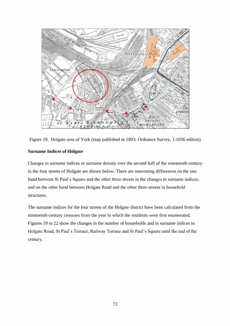
72
Figure 18. Holgate area of York (map published in 1893; Ordnance Survey, 1:1056 edition)
Surname Indices of Holgate
Changes in surname indices or surname density over the second half of the nineteenth century
in the four streets of Holgate are shown below. There are interesting differences on the one
hand between St Paul’s Square and the other three streets in the changes in surname indices,
and on the other hand between Holgate Road and the other three streets in household
structures.
The surname indices for the four streets of the Holgate district have been calculated from the
nineteenth-century censuses from the year in which the residents were first enumerated.
Figures 19 to 22 show the changes in the number of households and in surname indices in
Holgate Road, St Paul’s Terrace, Railway Terrace and St Paul’s Square until the end of the
century.

73
Figure 19. Surname index derived from census household heads and number of household
heads in Holgate Road
Figure 20. Surname index derived from census household heads and number of household
heads in St Paul’s Terrace
0
20
40
60
80
100
120
80
82
84
86
88
90
92
94
96
98
100
Num
ber
of
House
hold
Hea
ds
Surn
am
e In
dex
Year
CSI(H)
Household Heads

74
Figure 21. Surname index derived from census household heads and number of household
heads in Railway Terrace
Figure 22. Surname index derived from census household heads and number of household
heads in St Paul’s Square
The surname indices plotted from the household heads show similar trends in three of these
streets, namely Holgate Road, St Paul’s Terrace and Railway Terrace, but a reversal of this
pattern in St Paul’s Square. In the 20 years after 1841 the surname index of Holgate Road
heads fluctuated, but thereafter until 1891 the index fell as household heads with shared
surnames tended to grow in number in relation to heads with a unique surname in the street.
0
20
40
60
80
100
120
80
82
84
86
88
90
92
94
96
98
100
Nu
mb
er o
f H
ou
sehold
Hea
ds
Su
rnam
e In
dex
Year
CSI(H)
Household Heads
0
20
40
60
80
100
120
80
82
84
86
88
90
92
94
96
98
100
Num
ber
of
House
hold
Hea
ds
Surn
am
e In
dex
Year
CSI(H)
Household Heads

75
The surname indices in St Paul’s Terrace and Railway Terrace in 1871, when the streets were
under construction, were 100, that is the surnames of all the household heads were different.
This was a new fledgling community in 1871, no kinship heads having been attracted to the
terraces. After this date the indices fell as heads with shared surnames concentrated in the
houses of these two streets over the first 20 years of their existence until 1891. The final ten
years of the nineteenth century witnessed a reversal of this trend in each of these three streets
when indices rose to an extent as heads with shared surnames tended to decline. The
opposite pattern is seen in the indices in St Paul’s Square. The surname index derived from
the household heads in the square rose until 1891, and then fell in the last decade of the
century. Isolated families tended to dominate in the square throughout the century, and in
1891 there were no resident kinship household heads at all.
The indices from these four streets in the Holgate district suggest, in short, that kinship
families may have been attracted over most of the period to the two terraces of working-class
railway employees and to Holgate Road, but not to the more affluent quarter of St Paul’s
Square. The rentals of working-class housing were more attractive to kinship families than
the cost for middle-class families, even though these terraced houses were more expensive
than other forms of housing in the city.1 Home ownership meant the realization of that
independent status coveted by working people.2 Furthermore, just as there was variability in
surname densities in the streets of this neighbourhood, so there was some difference in
household composition. The average size of households, and of the number of adults and
children in each household, have been calculated in this section from the data in the census
surname indices. Figures 23 and 24 show the changes in household composition in the four
streets over the second half of the century, namely in the overall size of the households and
the number of children.3
1 A. August, The British Working Class, 1832 – 1940 (Harlow, 2007), pp. 17 – 21; S. Meacham, A Life Apart:
The English Working Class 1890-1914 (London, 1977), 38. Many properties in Holgate Road between 1876
and 1900 were occupied by their owner. Some were rented from private landlords, and few were owned by the
North Eastern Railway. The rate books for St Paul’s Terrace, Railway Terrace and St Paul’s Square are not
present with other rate books for Holgate (York Explore, Rate Books: Holgate 1876-1900, Ref no. PLU/9/1/16).
2 D. Englander, Landlord and Tenant in Urban Britain 1838 – 1918 (Oxford, 1983), pp. ix – xviii.
3 Average numbers of people per household (Mean household size or MHS (see Definitions)) and average
number of children (16 years and younger) per household (Children per household or CPH) have been
calculated from census data. MHS in this thesis includes all individuals listed in each household at any census.

76
Figure 23. Mean household size of houses in Holgate Road, St Paul’s Terrace, Railway
Terrace and St Paul’s Square
Figure 24. Number of children per household in Holgate Road, St Paul’s Terrace, Railway
Terrace and St Paul’s Square
Data have been calculated for each of the four streets from when they were first enumerated after 1841 until
1901.

77
Although isonymic household heads density differed in St Paul’s Square from the
neighbouring streets, it was in Holgate Road that differences in household size occurred over
the period. Average household size in Holgate Road was at its smallest at the first census
count, and at its highest in the other three streets when they were first occupied. Thereafter
households tended to become larger in Holgate Road as some new houses were built, and
smaller in St Paul’s Terrace, Railway Terrace and St Paul’s Square. The changes in the
number of children in the households show how these differences occurred. The households
expanded in Holgate Road with more adults as the number of children remained more or less
the same, and the families in the other streets diminished in size generally with fewer
children.4 There were usually fewer children in the houses of Holgate Road than in the other
three streets, and fewer children on average lived in all these households by the turn of the
century.5 The changes in household size and composition in Holgate do not measure fertility
decline; however, they are in line with national trends, as there was a fall in the crude birth
rate from the late 1870s and the earliest limitation of fertility in the professional classes.6
Three basic explanations have been offered for the declining fertility in the late nineteenth
century, namely the desire for a smaller family through considerations of cost, demands on
time and status, changes in natural fecundity, and changes in the methods and cost of birth
4 Burnett suggests that middle-class households in the mid-nineteenth century were larger than working-class
households because they sheltered more relatives, lodgers, visitors and servants; he notes that a middle-class
house in York had an average of 1.15 domestic servants (J. Burnett, A Social History of Housing 1815 – 1985
(London, 1986), p. 102). An increase in the number of household servants, however, does not account for the
increased number of adults per household in Holgate Road over the half century (adult servants in 82
households in Holgate Road in 1851 = 57 (average 0.7 servants per household); in 93 households in 1891 = 19
(average 0.2 servants per household); in 97 households in 1901 = 47 (average 0.5 servants per household).
5 Shifts in fertility in the early twentieth century produced clear differences in average family size and in the
numbers of children in families of different occupational groups; see M. Anderson, ‘The social implications of
demographic change’, in F.M.L. Thompson (ed.), The Cambridge Social History of Britain, 1750 – 1950:
Volume 2. People and their Environment (Cambridge, 1990), p. 44. Schürer has found that household size
began to fall only from the beginning of the twentieth century, but that mean household size remained relatively
static over the second half of the nineteenth century. There were fluctuating mean numbers of children within
households during this period (K. Schürer, E.M. Garrett, H. Jaadla and A. Reid, ‘Household and family structure
in England and Wales, 1851 – 1911: continuities and change’, Continuity and Change, 33 (2018), p. 375.).
6 E. Garrett, A. Reid, K. Schürer and S. Szreter, Changing Family Size in England and Wales: Place, Class and
Demography, 1891 – 1911 (Cambridge, 2001), pp. 1 and 321. Smith discusses the role of household formation
and age at marriage in the changes in fertility in England before the late nineteenth century: R.M. Smith,
‘Fertility, economy and household formation in England over three centuries’, Population and Development
Review, 7 (1981), p. 595.

78
control.7 Possibly the desire for a higher standard of living and concerns about housing,
utilities and furnishings encouraged the working-class parents of Holgate to limit their family
size.8
The Four Streets of Holgate
The parish of St Mary Bishophill Junior in Micklegate registration subdistrict included the
area of Holgate (later the ecclesiastical parish of St Paul) whose land and population were
disrupted in the later nineteenth century by the arrival of the railway and its workers. The
streets explored in Holgate are the working-class terraced housing of St Pauls Terrace and
adjoining Railway Terrace, and the more prosperous and elite housing of Holgate Road and
St Paul’s Square. They lie within a few yards of each other alongside the railway approach to
York station at the south-west boundary of the city. Holgate Road predated the other streets
by some centuries, but they all came to prominence as a result of the railway boom in
England during the period between 1830 and 1849. Holgate Road is a major arterial route
into the city. It leaves the township of Holgate at a stone bridge built across Holgate Beck in
1721, the boundary of the city’s suburbs.9 It travels the half mile or so to a junction with
Blossom Street, which in turn takes traffic a few hundred yards through Micklegate Bar into
the walled city. The Bishop Fields in the eighteenth century lay on either side of the road. At
the beginning of Victoria's reign the land around Holgate Road was almost entirely pasture
for cattle. Houses had been built towards its junction with the main thoroughfare into York
(Blossom Street), together with a few houses further out from the city. The road thereafter
showed linear development with time away from the city.10 The coming of the railway in the
late 1830s encouraged York Corporation to sell land on the north side of Holgate Road.
There was considerable development in the construction of houses of the villa type in Holgate
7 G. Alter, ‘Theories of fertility decline: a non-specialist’s guide to the current debate’, in J. Gillis, L. Tilly and
D. Levine (eds), The European Experience of Declining Fertility, 1850 – 1970 (Oxford, 1992), p. 14. Nelson
suggests that the middle classes limited their family sizes towards the end of the Victorian period in the
knowledge that the life expectancies of their children had improved (C. Nelson, Family Ties in Victorian
England (Westport, 2007), p. 4.). Szreter discusses the perceived relative costs of childbearing in S. Szreter,
Fertility, Class and Gender in Britain, 1860 – 1940 (1996, Cambridge, 2002), pp. 443 – 532.
8 P. Atkinson, ‘Family size and expectations about housing in the later nineteenth century: three Yorkshire
towns’, Local Population Studies, 87 (2011), p. 13.
9 C.B. Knight, A History of the City of York (York, 1944), p. 522.
10 G. Hodgson, A Walk down Holgate Road: giving a glimpse of a Victorian Suburb (York, 1997), pp. i-vii.

79
Road for residential purposes by the wealthier citizens.11 Behind this were built streets and
houses for the railway workers. This block of housing abutted the approach railway line from
Leeds into York station, and the marshalling yards and engine sheds (Figure 25). St Paul’s
Square was built between 1851 and 1867. Both St Pauls Terrace and Railway Terrace were
constructed between 1867 and 1872, relatively late in the development of housing adjoining
the railway in this area of Holgate.12 The railways thus contributed to the urban growth in
York and the building of working-class housing.
Figure 25. Railway and St Paul’s Terraces, St Paul’s Square and Holgate Road (map
published in 1893; Ordnance Survey, 1:1056 edition)
Railway and St Paul’s Terraces were linear two-storey housing with a small school at the
southerly end of St Paul’s Terrace, and separated by small back yards (Figures 26 and 27). St
Paul’s Square was also terraced housing, but the properties were three-storeyed with gardens
to the rear and faced a central tree-lined communal lawn. The houses along Holgate Road
were detached, relatively large spacious accommodation, and built with generous gardens
(Figure 28). Shops and businesses were interspersed with the houses, together with St Paul’s
11 Knight, History of the City of York, pp. 617, 657 and 668-669. Streets off Holgate Road were built between
1846 and 1872.
12 Similar housing was built to the west of the railway tracks on land abutting Holgate Road. The land was
offered for sale by auction in 1839 (York City Archives, TC 144/1), and streets were built between 1839 and
1851 (Knight, History of the City of York, pp. 668-669).
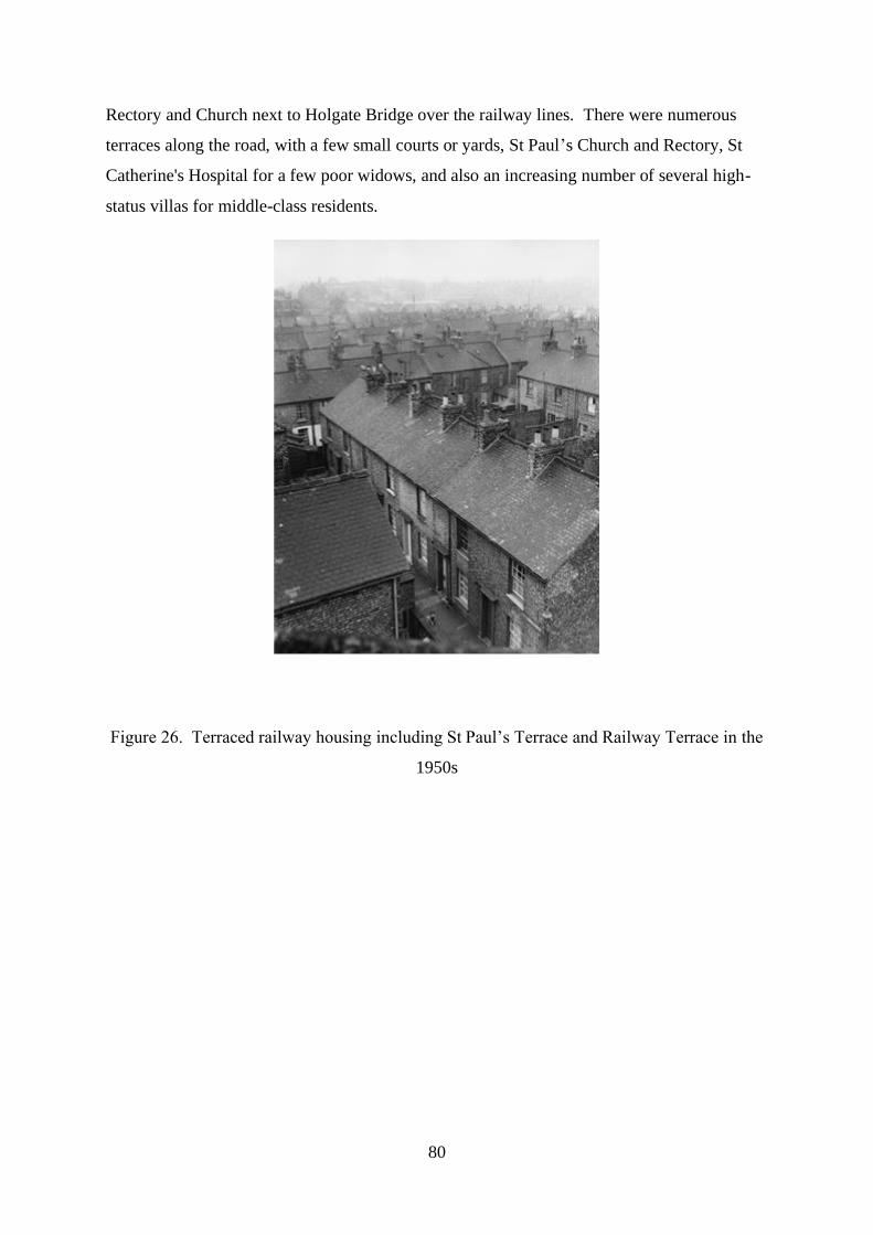
80
Rectory and Church next to Holgate Bridge over the railway lines. There were numerous
terraces along the road, with a few small courts or yards, St Paul’s Church and Rectory, St
Catherine's Hospital for a few poor widows, and also an increasing number of several high-
status villas for middle-class residents.
Figure 26. Terraced railway housing including St Paul’s Terrace and Railway Terrace in the
1950s

81
Figure 27. Back yards of railway housing in the Holgate area of York in the 1950s
Figure 28. Entrance to Mount Terrace from Holgate Road in 1922
Kinship Families of Holgate
The focus switches now to the kinship families in these Holgate streets and the forces that
shaped their life cycles and migration trajectories. The isonymic families of the streets
between 1841 and 1901 are named and listed from the census enumerators’ books in
Appendices 4 to 7. The appendices show all those heads of household coupled with a head of
the same surname in their street at each census until the end of the century. The highlighted

82
heads of household in these lists are those with probable or possible kinship links in the
street, in that they were born in the same or neighbouring place as another head of the same
surname, and/or lived in nearby houses in Holgate, and/or had the same occupation.
Kinship families are defined for our purposes as those families made of two or more
households in the same street with a head of the same surname who had an ancestor in
common, ie who were related by birth. There were 18 such families in total, and they are set
out in Tables 2 and 3.13 The distribution of heads of household of kinship families in these
streets is shown for one selected census year (1891) in Figure 29.14 There were similarities in
the social standing and occupations of the heads of households between Holgate Road and St
Paul’s Square, but a marked difference in the density and number of kinship families. They
were plentiful in Holgate Road and the opposite in St Paul’s Square. There were only four
families with a surname common to more than one head of household in the square across the
second half of the nineteenth century, and only one such family with a proven kinship link of
common ancestry. This was a family of two actuaries. William Newman, actuary to the
Yorkshire Life Assurance Company, moved to Holgate from the fashionable residences of St
Mary’s about a mile away, to be joined there by his son recently qualified from Cambridge
University, who shortly took the house next door. They lived in the relatively affluent
community of St Paul’s Square alongside household heads who shared no ties with their
neighbours through blood or marriage.
13 Family connections were sought in the censuses and baptismal records for all those heads of household who
shared a surname with at least one other head in the same street over the second half of the nineteenth century.
Heads related by birth were found in 7 of the 12 groups of heads with the same surname in Holgate Road;
corresponding figures for St Paul’s Terrace were 7 of 9; for Railway Terrace 3 of 4; for St Paul’s Square 1 of 4.
Tables 2 and 3 show the relationship between the heads of household, their places of birth and the occupation of
their fathers, the places and employment to which they moved before arriving in York, the streets and
employment within York itself before they arrived as a kinship family in Holgate, and finally their details as
kinship family members in the four streets.
14 Houses headed by kinship family members are shown in red, Railway Terrace in green, St Paul’s Terrace in
blue, St Paul’s Square in orange, and Holgate Road in yellow. The distribution of such houses in Holgate Road
is an approximation, since the house numbers in this street were not recorded accurately or reliably in the census
of 1891.

83
Figure 29. Distribution of heads of household of kinship families (red) in Holgate streets in
1891
There are stark differences in family migratory pathways in the other three streets depending
upon whether or not their livelihoods were gained by manual employment on the railway.
Working-class families, in which at least one and usually both relatives worked on the
railway, are seen in Table 2. These kinship families settled only in St Paul’s and Railway
Terraces. The more affluent and middle-class families, whose income did not come from the
railways, appear in Table 3 These close relatives came to live near each other only in
Holgate Road and St Paul’s Square.

84
Rel
atio
nshi
pS
urna
me
For
enam
eP
oBF
athe
r's
Occ
upat
ion
Mig
rati
on b
efor
e Y
ork
Occ
upat
ion
befo
re Y
ork
Res
iden
ce w
ithi
n Y
ork
bef
ore
kin
ship
fam
ily h
ome
Occ
upat
ion
wit
hin
Yor
k b
efor
e
kin
ship
fam
ily h
ome
Res
iden
ce a
s K
insh
ip f
amily
mem
ber
Occ
upat
ion
as K
insh
ip f
amily
mem
ber
Wil
liam
Mal
ton
Leed
sJo
iner
14 R
ailw
ay T
erra
ceR
ailw
ay w
agon
bui
lder
John
Mal
ton
Shoe
mak
er1
Rai
lway
Ter
race
Shoe
mak
er
John
Aco
mb
Ask
ham
Ric
hard
N
ot k
now
n2
addr
esse
s in
Wal
mga
tePo
lice
man
, the
n po
ulte
rer
32 R
ailw
ay T
erra
ceLi
ving
on
own
mea
ns; r
etir
ed g
roce
r
Wil
liam
Yor
kPo
lice
man
, pou
ltere
r, th
en g
roce
r2
addr
esse
s in
Wal
mga
te th
en 3
2 R
TFa
rm s
erva
nt in
32
RT
33 R
ailw
ay T
erra
ceR
ailw
ay s
hunt
er
Eli
zabe
thLi
verp
ool
Hul
l, th
en C
hest
erC
hild
, the
n N
ot k
now
n5
Cam
brid
ge S
tD
ress
mak
er5
Rai
lway
Ter
race
Dre
ssm
aker
Sam
uel
Live
rpoo
lH
ull,
then
Che
ster
Chi
ld, t
hen
Fitte
r &
Tur
ner
5 th
en 4
Cam
brid
ge S
tE
ngin
e fi
tter
4 R
ailw
ay T
erra
ceE
ngin
e fi
tter
John
Gat
eshe
ad
Het
ton
le H
ole
Dur
ham
,
then
Gat
eshe
ad, t
hen
Dar
ling
ton
Bla
cksm
ith29
SPT
Bla
cksm
ith39
St P
aul's
Ter
race
Bla
cksm
ith
Ada
mG
ates
head
Bla
cksm
ithD
arli
ngto
nC
hild
29 S
PTB
lack
smith
34 S
t Pau
l's T
erra
ceB
lack
smith
Wil
liam
Dur
ham
Win
lato
nN
ot k
now
nN
ot k
now
nU
nion
Str
eet,
then
55
Pric
e St
Coa
chm
aker
22 S
t Pau
l's T
erra
ceR
ailw
ay c
arri
age
buil
der
Wil
liam
Dur
ham
Gat
eshe
adR
ailw
ay c
arri
age
buil
der
Not
kno
wn
Chi
ldU
nion
Str
eet,
then
55
Pric
e St
Chi
ld, t
hen
Join
er21
St P
aul's
Ter
race
Rai
lway
car
riag
e bu
ilde
r
John
Lanc
ashi
re S
kert
onN
ot k
now
nC
hild
Dal
e St
, the
n B
ilto
n St
, the
n St
Cec
ilia
Plac
e, th
en 6
3 SP
T
Chi
ld, t
hen
Coa
ch m
aker
, the
n
Rai
lway
coa
ch b
uild
er44
St P
aul's
Ter
race
Rai
lway
fore
man
car
riag
e sh
op w
orke
r
Cha
rles
Lanc
ashi
re S
kert
onN
ot k
now
nC
hild
Dal
e St
, the
n B
ilto
n St
, the
n N
ewbe
gin
St, t
hen
Cha
rlto
n St
Chi
ld, t
hen
Coa
ch tr
imm
er56
St P
aul's
Ter
race
Rai
lway
coa
ch p
lum
mer
Rob
ert
Dar
ling
ton
Stoc
kton
, the
n D
arli
ngto
nC
hild
, the
n W
oolc
ombe
r, th
en
Boi
ler
smith
Bai
nbri
dge
Sq P
rice
St
Rai
lway
boi
ler
smith
70 S
t Pau
l's T
erra
ceR
ailw
ay b
oile
r sm
ith
Wil
liam
Dar
ling
ton
Rai
lway
boi
ler
smith
Bai
nbri
dge
Sq P
rice
St,
then
17
Pric
e St
Rai
lway
car
riag
e tr
imm
er11
St P
aul's
Ter
race
Rai
lway
car
riag
e tr
imm
er
Jose
phB
isho
ptho
rpe
Moo
r M
onkt
onW
heel
wri
ght
5 SP
TR
ailw
ay w
agon
bui
lder
55 S
t Pau
l's T
erra
ceJo
iner
Edw
ard
Moo
r M
onkt
onR
ailw
ay w
agon
bui
lder
5, th
en 5
5 SP
TC
hild
, the
n G
arde
ner
appr
entic
e14
St P
aul's
Ter
race
Rai
lway
goo
ds p
orte
r
Tho
mas
Rip
onK
nare
sbor
ough
, the
n R
ipon
Labo
urer
, the
n A
g im
plem
ent m
aker
Oxf
ord
St, t
hen
SPT
, the
n 51
SPT
Eng
ine
fitte
r, th
en E
ngin
e dr
iver
52 S
t Pau
l's T
erra
ceE
ngin
e dr
iver
Tho
mas
Man
ches
ter
Eng
ine
driv
erN
ot k
now
nC
hild
Oxf
ord
St, t
hen
SPT
, the
n 51
& 5
2 SP
TC
hild
, the
n Fi
tter,
then
Rai
lway
sto
ker
31 S
t Pau
l's T
erra
ceE
ngin
e dr
iver
Wil
liam
Yor
kE
ngin
e dr
iver
Not
kno
wn
Chi
ldSP
T, t
hen
52 S
PTC
hild
, the
n Sh
oem
aker
51 S
t Pau
l's T
erra
ceSh
oem
aker
Edw
ard
Yor
kE
ldon
St,
then
Low
ther
St,
then
76
Low
ther
St,
then
New
bigi
n St
Chi
ld, t
hen
Join
er22
then
53
St P
aul's
Ter
race
Rai
lway
wag
gon
buil
der
Geo
rge
Yor
kLo
wth
er S
t, th
en 7
6 Lo
wth
er S
t, th
en 9
7
Low
ther
St
Chi
ld, t
hen
Eng
ine
fitte
r, th
en R
ailw
ay
sign
al fi
tter
23 S
t Pau
l's T
erra
ceR
ailw
ay s
igna
l fitt
er, t
hen
insp
ecto
r
Sibl
ings
Sim
pson
Fath
er &
Son
Hut
ton
Fath
er &
2
Sons
Mal
thou
se
Fath
er &
Son
Bir
ch
Sibl
ings
Byr
neN
ot s
tate
d (D
ubli
n)
Fath
er &
Son
Alp
ort
Fath
er &
Son
Hal
l
Fath
er &
Son
Ren
niso
n
Sibl
ings
Rot
herh
amM
illw
righ
t/Whe
elw
righ
t
Sibl
ings
Mid
dlet
onSe
xton
at M
alto
n C
emet
ery
Tab
le 2
. R
ailw
ay k
insh
ip f
amil
ies
of
St
Pau
l’s
Ter
race
and R
ailw
ay T
erra
ce

85
Rela
tions
hip
Surn
ame
Fore
nam
ePo
BFa
ther
's O
ccup
atio
nM
igra
tion
befo
re Y
ork
Occ
upat
ion
befo
re Y
ork
Resid
ence
with
in Y
ork
befo
re k
insh
ip
fam
ily h
ome
Occ
upat
ion
with
in Y
ork
befo
re
kins
hip
fam
ily h
ome
Resid
ence
as K
insh
ip fa
mily
mem
ber
Occ
upat
ion
as K
insh
ip fa
mily
mem
ber
Dani
elM
ary
York
s Whi
xley
Farm
erGr
een H
amme
rton
Farm
er's
wife
and
daug
hter
Holg
ate C
resc
ent
Livi
ng o
n ow
n mea
ns
Dani
elJo
hnYo
rks W
hixl
ey3
then 2
Hol
gate
Terra
ceRe
tired
farm
er
Dani
elM
ary
York
s Whi
xley
3 Ho
lgate
Ter
race
Livi
ng o
n ow
n mea
ns
Day
Sept
imus
York
Line
n dra
per o
f Spu
rrier
gate
Spur
rierg
ateCh
ildHo
lgate
Cre
scen
tLi
nen d
rape
r
Day
Jame
sYo
rkLi
nen d
rape
r of S
t Sav
iour
gate
New
ton o
n Ous
eDr
aper
Holg
ate T
erra
ceLi
nen d
rape
r
Forb
esGe
orgi
ana
Durh
am W
ellin
gton
Neith
rop,
Oxf
ords
hire
Vica
r's w
ife10
then
53
Holg
ate T
erra
ceRe
nts o
f hou
ses
Forb
esGe
orgi
ana
Banb
ury O
xon
Vica
rNe
ithro
p, O
xfor
dshi
reNo
t stat
ed10
then
53
Holg
ate T
erra
ceNo
t stat
ed
Harri
son
Rich
ard
York
s Gill
ing
Whe
ldra
keJo
iner
Oxfo
rd S
treet
Join
er &
Car
pente
r76
Hol
gate
Road
Join
er
Harri
son
Will
iam
York
s Whe
ldra
ke77
Hol
gate
Road
Bric
klay
er
Hatti
eJo
seph
York
s Stai
nfor
thAd
wic
k le S
treet,
then
Bar
nby u
pon D
on, t
hen G
ate F
ulfo
rdSh
oema
ker,
then A
g lab
, the
n Wire
man
21 W
est P
arad
eTe
legr
aph c
lerk
Hatti
eGe
orge
York
s Adw
ick l
e Stre
etW
irema
nBa
rnby
upon
Don
, the
n Gate
Ful
ford
Child
, the
n Wire
man
2 Ho
lgate
Roa
dTe
legr
aph w
orke
r
Haw
kin/
sJo
hn H
orsle
yPo
pple
ton
Huby
, the
n Oul
ston Y
orks
hire
Farm
serv
ant,
then H
ind
79 H
olga
te Ro
adDa
iryma
n & G
roce
r, the
n Coa
l mer
chan
t
Haw
kin/
sTh
omas
Popp
leto
nDa
rton,
then B
arug
h Yor
kshi
reAg
lab,
then
Far
mer a
nd S
hopk
eepe
r4
Holg
ate R
oad
Frui
terer
& G
arde
ner,
then P
hoto
grap
hic a
rtist
Pick
erin
gJo
hnAc
aster
Mal
bis
Farm
erM
atloc
kM
erch
ant
Holg
ate H
illRe
tired
woo
llen m
erch
ant
Pick
erin
gPa
rker
Bish
optho
rpe
Farm
erTh
e Mou
nt, th
en M
ount
Para
deSo
licito
r's cl
erk
59 H
olga
te Hi
llCa
shie
r to
Solic
itor,
then A
nnui
tant
New
man
Will
iam
York
Leed
sAp
pren
tice
St H
elen
's Sq
uare
, the
n St M
arys
Actua
ry22
St P
auls
Squa
reRe
tired
actua
ry
New
man
Phili
pYo
rkAc
tuary
St M
arys
Child
22, t
hen 2
3 St
Pau
ls Sq
uare
Actua
ry
Cous
ins
Fathe
r & S
on
Sibl
ings
Mot
her &
Daug
hter
Sibl
ings
Fathe
r & S
on
Sibl
ings
Farm
er
Tab
le 3
. N
on
-Rai
lway
kin
ship
fam
ilie
s of
Holg
ate
Road
an
d S
t P
aul’
s S
qu
are
86
The working-class railway kinship families of St Paul’s Terrace and Railway Terrace in the
nineteenth century were either fathers and their sons, or pairs of siblings. Similar relations
took up residence in Holgate Road, and a vicar’s widow and her daughter and some cousins
also migrated into Holgate Road.15 Arrivals into the working-class terraces had been born
mainly in the industrial regions of the North East and Lancashire, such as Gateshead and
Darlington, Liverpool and Skerton near Lancaster. These families evidently did not originate
in the first wave of the rural exodus.16 A small number of railwaymen in these kinship
families had moved into Holgate from York itself and the villages within a few miles of the
city. Rural origins were the norm, however, for the kinship families of Holgate Road, most
of them arriving from villages in the vicinity of York. Only one family came from further
afield, the vicar’s widow and daughter making the long journey from a parish in rural
Oxfordshire to the ecclesiastically important city of York.
The stock from which the working-class families of the two terraces emerged was manual or
semi-skilled labour. The father of William and John Middleton was the sexton at Malton
cemetery in North Yorkshire, the father of Elizabeth and Samuel Rotherham was a millwright
and wheelwright of Liverpool, and James Byrne with his two sons had migrated from Dublin
to Lancashire, presumably in flight from the potato famine in Ireland. These families were
not socially mobile. The kinship families of Holgate Road, by contrast, showed some signs
of social climbing, and some settled in this more affluent community in retirement. The
Daniels, a wealthy farming family in a village outside the city, moved into York on
retirement, and cousins John and Parker Pickering came from a farming heritage to Holgate
Road following careers as a woollen merchant and solicitor’s cashier.17 Others established
trades and businesses along the road, rising from more humble origins on the land, such as
15 The assumption is made that Septimus and James Day were cousins, since they had the same occupation of
linen draper in Holgate Road, and both their fathers were linen drapers of nearby streets in York. The ancestry
of their fathers has not been confirmed from parish registers.
16 J. Saville, Rural Depopulation in England and Wales, 1851-1951 (London, 1957), p. 5. Saville notes that a
considerable proportion of English rural parishes began population decline between 1821 and 1851.
17 The gross value of the estate of William Newman at his death, resident of St Paul’s Square, was about £2000,
equating to more than £200,000 in today’s terms (registered at the District Probate Registry of York on 12
January 1903). The estate of the vicar’s widow was valued at about £2700 in 1897, equating to more than
£300,000 in today’s terms (registered at the District Probate Registry of York on 8 June 1897). Mary Daniel, a
spinster and annuitant on leaving farming, left an estate valued at £11,324 in 1894, a figure in excess of a
million pounds in today’s terms (registered at the District Probate Registry of York on 2 January 1894).
Monetary values derived from: www.bankofengland.co.uk/monetary-policy/inflation-calculator.

87
the Harrison brothers’ joinery and bricklaying businesses next door to each other and the
Hawkins brothers’ market gardening and provisions concerns.
Kinship families often moved some distance from their birthplace before their arrival in
York. These distances occasionally were short, even from one village to the next, but
sometimes longer from one town or city to another. Some men who were destined to work
on the railways in the working-class terraces of Holgate moved initially from one industrial
base to another: a joiner who moved from Malton to Leeds; a fitter and turner who moved
from Liverpool to Chester via Hull; a blacksmith who moved from Gateshead to Hetton-le-
Hole, Durham, then Darlington; a boilersmith who moved from Darlington to Stockton then
back to Darlington again; and a wheelwright who moved from the rural village of
Bishopthorpe just outside York to a neighbouring village. Some of these individuals
migrated as children with their labouring families. Likewise some tradesmen, professional
persons and farming stock migrated via places other than York before settling there as
kinship families. The wife of the vicar in Neithrop, Oxfordshire, was born in Durham. The
telegraph workers of Holgate Road settled in several small places in Yorkshire before
arriving in York, as did the progeny from workers on the land. These more affluent arrivals
in Holgate Road had tended to leave their birthplaces as working adults, not as children as the
working-class families of Holgate were prone to do. Seemingly the working-class kinship
families of the two terraces in Holgate had migrated to affordable and available housing at an
earlier stage in their life cycle than the middle-class families of Holgate Road.18
Having arrived in York, all but one of the families destined to settle as kinship groups in the
railway terraces of Holgate changed addresses in the city, usually more than once and up to
four times. These houses were invariably the same working-class terraces as those they came
to inhabit in Holgate. Sometimes relatives moved into Railway Terrace or St Paul’s Terrace
in the same or separate houses, only to move again along the street as head of household in a
new home. In five of the ten kinship families who came to inhabit these two terraces, father
lived next door to his son or brother next door to his sibling. The retirees, tradesmen,
businessmen and professionals of Holgate Road and St Paul’s Square, on the other hand,
tended not to live elsewhere within the city before arrival in Holgate. But, just like their
18 Middle-class home ownership represented the realization of that independent status coveted by working-class
people (Englander, Landlord and Tenant, pp. ix – xviii).

88
working-class neighbours a few streets away, kinship family members tended to inhabit
adjacent well-to-do houses.
Walmgate
This section plots changes in the surname indices in two streets in the low-lying Walmgate
district of York and describes the kinship families that lived there. Long Close Lane and
Hope Street are shown in red in Figure 30. They are adjoined and run alongside the city wall
(black) a short distance from Walmgate itself (blue). The area was prone to flooding from
the Foss (shown in orange) which lay several streets to the north of Long Close Lane and
Hope Street.
Figure 30. Walmgate area of York (map published in 1893; Ordnance Survey, 1:1056
edition)
In contrast with the relatively new Victorian railway housing of Holgate, the district of
Walmgate at the south east border of the City of York was built by the end of the Viking

89
age.19 Walmgate was enclosed within the mediaeval defences of the city by the twelfth
century, when the Bar (or gate) was built and the River Foss and the low-lying marsh were
considered sufficient defence to obviate the construction of a wall in this area. The Foss was
widened to make the King’s pool, a lake which served the mills of the castle and supplied fish
for the household there. Three churches were built in Walmgate in the twelfth century, St
Denys, St Margaret and St Peter-le-Willows. Common land (Walmgate stray) provided
pasture for animals outside the walls.
Walmgate once had many mediaeval houses and was an aristocratic part of the city. Ribbon
development took place outside the Bar in the twelfth century and the leper hospice of St
Nicholas was built there. The inhabitants of Walmgate were quarantined in their houses in
the plague of 1631 and a survey of the following year recorded more paupers in this ward
than in any other in the city.20 The number of paupers in Walmgate in 1637 was three times
greater than in the most prosperous district of York and nearly half of the households there
were too poor to pay the Hearth Tax of 1672. Poor relief in the ward averaged about £100
per annum during the 1720s whereas relief was about £70 in Bootham and Micklegate. The
area became prosperous in the later eighteenth century when many houses were used as town
residencies by wealthy families, who subsequently rented out then sold these properties. A
school was established outside Walmgate Bar in 1798 for the education of poor children.
Six churches once stood in Walmgate, those of St Denys, St Margaret, St Mary, St George, St
Edward the Martyr and St Peter-le-Willow. New churches were built to meet the demands of
inhabitants outside the city walls in Victorian York, including the Roman Catholic church of
St George in 1850 to accommodate the Irish influx. A girls school attached to the church
opened in 1852 and this became mixed 20 years later. The pupils were predominantly Irish
and taught by the Sisters of Charity of St Vincent de Paul. The Sunday School for Walmgate
in 1819 educated 100 boys and 124 girls. Nonconformity also had a foothold in the area. A
19 All the details of the history of Walmgate quoted in this and the following page have been taken from 3 texts:
A. Stacpoole (ed.), The Noble City of York (York, 1972); V. Wilson, The Walmgate Story (2006, York, 2012);
and P. Nuttgens (ed.), The History of York: From Earliest Times to the Year 2000 (Pickering, 2001).
20 See C. Galley, The Demography of Early Modern Towns: York in the Sixteenth and Seventeenth Centuries
(Liverpool, 1998), pp. 76 – 83. Only the small parish of St Lawrence in Walmgate was badly affected by plague
in 1631.
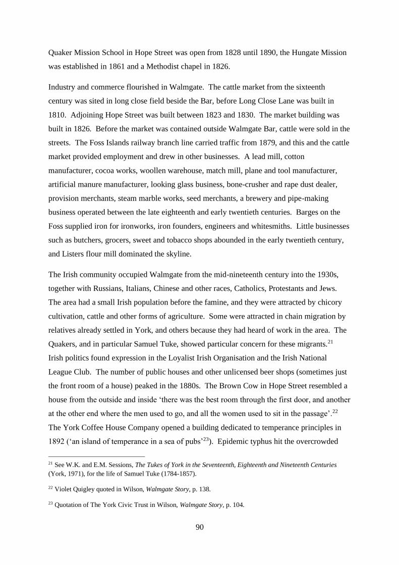
90
Quaker Mission School in Hope Street was open from 1828 until 1890, the Hungate Mission
was established in 1861 and a Methodist chapel in 1826.
Industry and commerce flourished in Walmgate. The cattle market from the sixteenth
century was sited in long close field beside the Bar, before Long Close Lane was built in
1810. Adjoining Hope Street was built between 1823 and 1830. The market building was
built in 1826. Before the market was contained outside Walmgate Bar, cattle were sold in the
streets. The Foss Islands railway branch line carried traffic from 1879, and this and the cattle
market provided employment and drew in other businesses. A lead mill, cotton
manufacturer, cocoa works, woollen warehouse, match mill, plane and tool manufacturer,
artificial manure manufacturer, looking glass business, bone-crusher and rape dust dealer,
provision merchants, steam marble works, seed merchants, a brewery and pipe-making
business operated between the late eighteenth and early twentieth centuries. Barges on the
Foss supplied iron for ironworks, iron founders, engineers and whitesmiths. Little businesses
such as butchers, grocers, sweet and tobacco shops abounded in the early twentieth century,
and Listers flour mill dominated the skyline.
The Irish community occupied Walmgate from the mid-nineteenth century into the 1930s,
together with Russians, Italians, Chinese and other races, Catholics, Protestants and Jews.
The area had a small Irish population before the famine, and they were attracted by chicory
cultivation, cattle and other forms of agriculture. Some were attracted in chain migration by
relatives already settled in York, and others because they had heard of work in the area. The
Quakers, and in particular Samuel Tuke, showed particular concern for these migrants.21
Irish politics found expression in the Loyalist Irish Organisation and the Irish National
League Club. The number of public houses and other unlicensed beer shops (sometimes just
the front room of a house) peaked in the 1880s. The Brown Cow in Hope Street resembled a
house from the outside and inside ‘there was the best room through the first door, and another
at the other end where the men used to go, and all the women used to sit in the passage’.22
The York Coffee House Company opened a building dedicated to temperance principles in
1892 (‘an island of temperance in a sea of pubs’23). Epidemic typhus hit the overcrowded
21 See W.K. and E.M. Sessions, The Tukes of York in the Seventeenth, Eighteenth and Nineteenth Centuries
(York, 1971), for the life of Samuel Tuke (1784-1857).
22 Violet Quigley quoted in Wilson, Walmgate Story, p. 138.
23 Quotation of The York Civic Trust in Wilson, Walmgate Story, p. 104.

91
Irish inhabitants of Walmgate in 1847, followed by an outbreak of cholera the following year.
A temporary fever hospital housed typhus victims in 1850, replaced by a permanent building
in 1881.
Dr Thomas Laycock, physician to the York dispensary, reported in dispassionate language
the grossly insanitary condition of life in Long Close Lane and Hope Street at the middle of
the nineteenth century shortly before the arrival of Irish migrants. No drainage or sewerage
had been built into the cottage tenements, and the street was ‘unpaved and so full of ruts and
ashes and all kinds of filth, as to be quite impassable to pedestrians or even to persons on
horseback’.24 The Lane had been built somewhat higher than the houses and the yards such
that stagnant mud flowed through the premises and even into the street behind. One privy
had been built to service as many as 14 families.25 The door of the common privy at each end
of the Lane opened on to the door of a tenement with no ventilation between the two. Night
soil was retained and barrowed during the night from the yards into the street. The sewage
was then carted away to large dung hills, one of which lay at the side of the nearby River
Foss. Inhabitants complained about the stench. In addition to human effluent, the manure
from numerous pigsties, cow-houses and stables in the courts and yards compounded an
already intolerable situation. The street was so filthy that even children would not play in
it.26 Paid scavengers made an attempt to clean the alleys and courts.27
Walmgate thus had witnessed relative affluence for part of its history, bustling industry, and
poverty due in some measure to its low-lying position and proximity to the River Foss. Some
oral testimonies, however, speak of integration and a strong spirit of community. ‘We all
24 First Report of The Commissioners for inquiring into the state of large towns and populous districts 1844;
Report on the sanatory condition of the City of York, by Thos Laycock, M.D. Also Y.H. 17.8.1844: Report on
the Sanatory State of York, in Reply to the Questions Circulated by the Health of Towns Commission. Mr
Snow, one of the missionaries of the Hungate district of York, reported to the York City Mission that Walmgate
‘presents more than its just proportion of the low and the lost, the depraved and demoralised of the York
population … and that absence of mental and moral culture which such an unpromising exterior would indicate.’
See also S.M. Gaskell (ed.), Slums (Leicester, 1990), p. 2.
25 The archaeological excavation of one such sewerage system is described in P.A. Connelly, ‘Flush with the
past: An insight into late nineteenth-century Hungate and its role in providing a better understanding of urban
development’, International Journal of Historical Archaeology, 15 (2011), p. 607.
26 Y.H., 5.2.1848. A report of ‘… several boys playing, during which one of them ran into Long Close Lane,
when a companion called out to him not to go there, as that street was filthy and unwholesome to be in; …’
27 Y.H., 25.11.1843.

92
turned to crime’, said Owen Calpin of life in the 1920s, ‘we didn’t call it crime, we called it
existence … We never left Walmgate as kids … Every house we visited was exactly the same
as ours’. His grandparents lived in Hope Street: ‘It was lovely to listen on dark nights to these
old people, six or seven old Irishmen sitting round the fire. If they did say anything against
the English, it used to go over my head because I was listening for the stories from Ireland ...
Tales of Ireland and the old days inevitably brought forth an emotional response, and the men
would often cry… There were English families with [Irish families] but they tolerated each
other for the simple reason that they were all living in the same environment. They were
sharing whatever they had, over the years it did form a camaraderie between them …’ The
Irish loved to hear songs which reminded them of home.28
Attempts to improve living conditions in Walmgate began in the mid-nineteenth century.29
The Local Board of Health drained the Foss Islands from 1852, and began an attack on the
worst slums in 1872 with proceedings to condemn houses in Barleycorn Passage. The
concerted assault on slum housing began in 1919 and in the next twenty years almost 2000
houses were demolished and new housing estates built elsewhere in the city. Mass clearances
began in 1933-34.
Surname Indices of Walmgate
The surname indices drawn from the populations of Long Close Lane and Hope Street in the
Victorian period are shown in Figures 31 to 35. The graphs are calculated from the total
populations of each street, the total Irish- and York-born populations, the adult Irish- and
York-born populations, and the Irish- and York-born household heads across all of the
censuses.30
28 Owen Calpin quoted in Wilson, Walmgate Story, pp. 47, 98, 99 and 102.
29 Stacpoole, The Noble City of York, p. 330. See also Connelly, ‘Flush with the past’, p. 609.
30 The individuals included in the Irish population are those whose place of birth was recorded as Ireland in the
censuses, and the individuals registered in the York population are those whose place of birth was recorded as
York. The census of 1841 does not make this distinction in the place of birth of the residents. The surname
indices calculated from household heads are drawn from families in Long Close Lane and Hope Street
combined, since the number of houses in each street individually was relatively small.
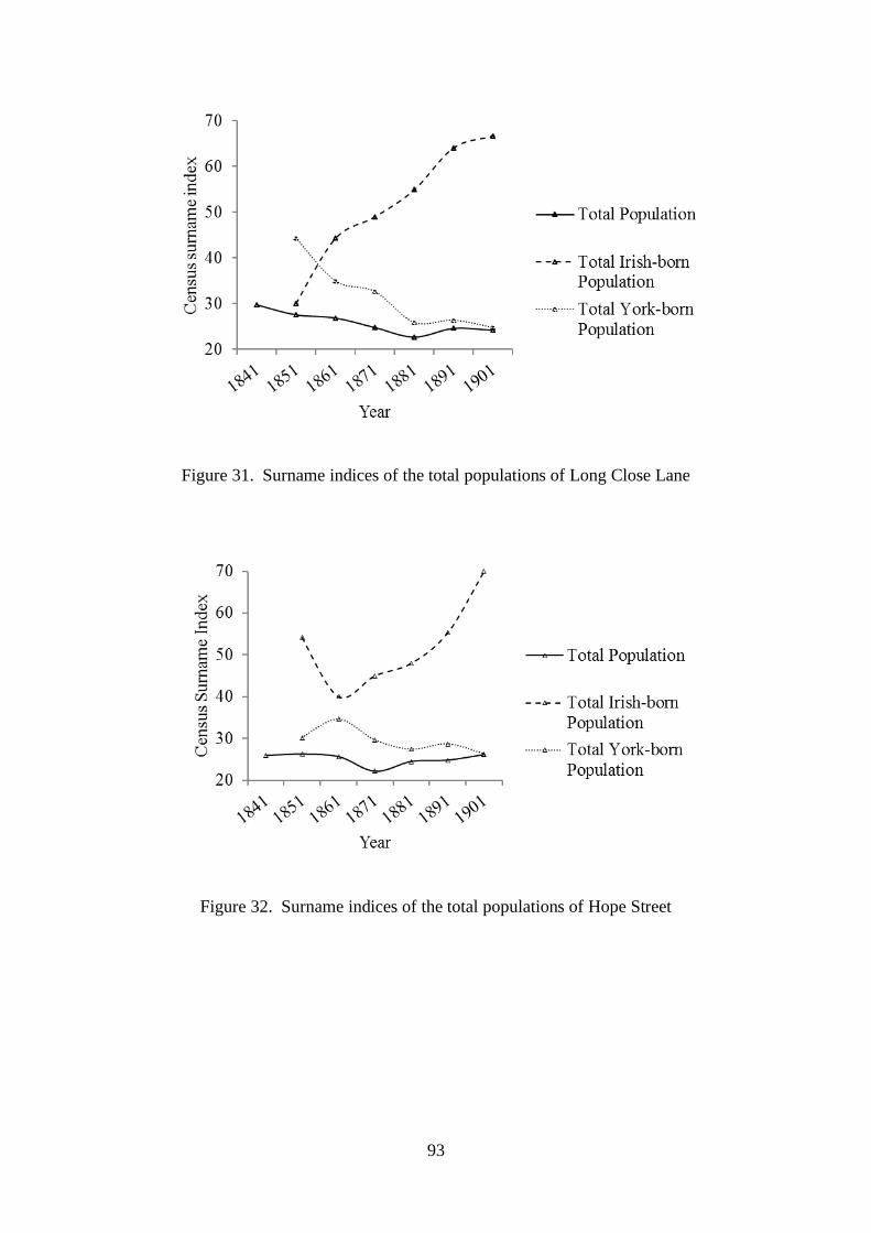
93
Figure 31. Surname indices of the total populations of Long Close Lane
Figure 32. Surname indices of the total populations of Hope Street

94
Figure 33. Surname indices of the adult populations of Long Close Lane
Figure 34. Surname indices of the adult populations of Hope Street

95
Figure 35. Surname indices of the household heads of Long Close Lane and Hope Street
The graphs show similar patterns in the two streets from 1861 until the end of the century in
the total and adult populations. They show little variation, but usually a downward trend over
the period. This implies that there was generally a minor fall in the number of surnames
relative to people (or possibly a minor increase in density of kinship families) in the streets
across the second half of the nineteenth century.
Analysis of the populations in the census years once the residents have been separated into
Irish and York birthplace, however, shows a marked contrast in surname indices after 1861.
The total and adult Irish populations showed a low surname index at this census and
thereafter a steady rise until the end of the century, indicating a rising number of surnames
relative to people, or possibly a falling proportion of related household members in the years
after the arrival of the first famine immigrants in York. On the other hand, the total and adult
indigenous York-born populations in these streets showed their lowest surname index in
1901, indicating the steady relative decline of surnames and possibly the growth of related
York household members over this period. This switch of Irish- and York-born kinship
families is seen in household heads only in the last decade of the nineteenth century. The
overall picture that emerges from this look at the Irish residents in Long Close Lane and
Hope Street is a rise in the number of surnames of Irish immigrants relative to the number of
people. A possible explanation includes the arrival of related people with the same surname
(or unrelated people coincidentally with the same common Irish surname) and then their
dilution as the century progressed as people intermarried, bore children in York, or left the

96
street. Such changes in the immigrant population match the adaptation seen in Victorian
London, where the demographic behaviour of the urban Irish soon came to resemble the host
population.31
However, the picture is somewhat different in the two streets in the early years of the Irish
immigration in the decade before 1861. The surname indices related to the Irish residents
rose and the indices related to the indigenous York residents fell in Long Close Lane in the
1850s, with the opposite pattern in Hope Street. The density of Irish people with the same
surname fell over the course of this decade in Long Close Lane (as it did for the rest of the
century), and rose in Hope Street. Possibly there was a different pattern of arrival of the
immigrant kinship families (or unrelated families with the same common surname) in the two
streets. The indices suggest they may have arrived before 1851 in Long Close Lane and then
diluted over the ensuing decades, but continued to arrive in Hope Street until 1861. Possibly
immigrant Irish families saturated available housing in Long Close Lane soon after their
arrival en masse into York and thereafter moved into residences in Hope Street.
The Two Streets of Walmgate
Long Close Lane and Hope Street were in the parish of St George (Figure 36). The houses
had two floors with a single room on each, and had access at the rear to communal yards with
privies. Narrow passages between houses connected the streets to some of these yards, which
were given their own identity with separate names at the censuses. These named yards are
highlighted in yellow on the map: Pawson’s and Skelton’s yards, Wood’s yard, Square &
Compass yard and Lewis yard behind Long Close Lane, and Place’s yard and Hotham’s yard
between the two streets. Some houses and tenements clustered around these yards. A public
house, the Brown Cow, was part of the terraced housing in Hope Street (Figure 37), and a
somewhat larger public house, the Square & Compass, lay at the end of Long Close Lane
(blue on the map).
31 L. Lees, Exiles of Erin: Irish Migrants in Victorian London (Manchester, 1987), pp. 136 - 138.

97
Figure 36. Long Close Lane and Hope Street (map published in 1893; Ordnance Survey,
1:1056 edition)
Figure 37. Long Close Lane in the early twentieth century
The rear of the Brown Cow public house faces Duke of York Place in Long Close Lane
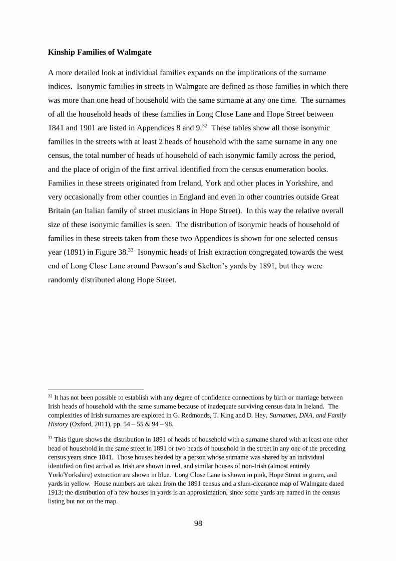
98
Kinship Families of Walmgate
A more detailed look at individual families expands on the implications of the surname
indices. Isonymic families in streets in Walmgate are defined as those families in which there
was more than one head of household with the same surname at any one time. The surnames
of all the household heads of these families in Long Close Lane and Hope Street between
1841 and 1901 are listed in Appendices 8 and 9.32 These tables show all those isonymic
families in the streets with at least 2 heads of household with the same surname in any one
census, the total number of heads of household of each isonymic family across the period,
and the place of origin of the first arrival identified from the census enumeration books.
Families in these streets originated from Ireland, York and other places in Yorkshire, and
very occasionally from other counties in England and even in other countries outside Great
Britain (an Italian family of street musicians in Hope Street). In this way the relative overall
size of these isonymic families is seen. The distribution of isonymic heads of household of
families in these streets taken from these two Appendices is shown for one selected census
year (1891) in Figure 38.33 Isonymic heads of Irish extraction congregated towards the west
end of Long Close Lane around Pawson’s and Skelton’s yards by 1891, but they were
randomly distributed along Hope Street.
32 It has not been possible to establish with any degree of confidence connections by birth or marriage between
Irish heads of household with the same surname because of inadequate surviving census data in Ireland. The
complexities of Irish surnames are explored in G. Redmonds, T. King and D. Hey, Surnames, DNA, and Family
History (Oxford, 2011), pp. 54 – 55 & 94 – 98.
33 This figure shows the distribution in 1891 of heads of household with a surname shared with at least one other
head of household in the same street in 1891 or two heads of household in the street in any one of the preceding
census years since 1841. Those houses headed by a person whose surname was shared by an individual
identified on first arrival as Irish are shown in red, and similar houses of non-Irish (almost entirely
York/Yorkshire) extraction are shown in blue. Long Close Lane is shown in pink, Hope Street in green, and
yards in yellow. House numbers are taken from the 1891 census and a slum-clearance map of Walmgate dated
1913; the distribution of a few houses in yards is an approximation, since some yards are named in the census
listing but not on the map.

99
Figure 38. Distribution of isonymic heads of household of Irish (red) and non-Irish (blue)
families in Walmgate streets by 1891
Isonymic families are shown in graphical format in Figures 39 and 40. These figures show
for each street and at each census the total number of ‘new’ arrivals of isonymic families,
separated by their place of origin (or birthplace). New arrivals refer to household heads with
a surname that had not been present as a head in previous censuses.
Figure 39. New isonymic family arrivals in Long Close Lane

100
Figure 40. New isonymic family arrivals in Hope Street
Several differences are apparent in isonymic families between these two streets. Hope Street
housed many more such families across the half century than Long Close Lane. At the start
of the period Irish headship arrivals in Hope Street were heavily outnumbered by arrivals
from Yorkshire (and presumably from York itself). The new arrivals from York and
elsewhere declined in general in both streets by the end of the century. As predicted from the
surname indices, the Irish isonymic head arrivals peaked in Long Close Lane in 1851 and
declined thereafter. There were no more new arrivals after 1871. In Hope Street on the other
hand, new isonymic family head arrivals peaked 10 years later than in Long Close Lane, and
they continued to arrive until at least 1891. Possibly the availability of housing or the desire
to live in proximity to fellow countrymen influenced this pattern.
On the basis of this analysis the largest isonymic families are explored now with census
information and other qualitative sources. Isonymic families identified in the two appendices
with a total of 7 or more household heads in Long Close Lane and 9 or more in Hope Street
across this period were chosen for this further study (Tables 4 and 5). These tables show for
each family the birthplace of the first head (or heads) of household to arrive, the number of
household heads in the subsequent censuses, and the total number of heads of household
across the period. The stippled boxes indicate those census years before the first arrival of a
head of household of an isonymic family. The plots of these isonymic families are tabulated
in Appendix 10.
0
5
10
15
20
25
Num
ber
of
New
Arr
ival
s of
Isonym
ic
Fam
ilie
s
Year
Origin from Ireland
Origin Elsewhere

101
Table 4. Isonymic household heads of Long Close Lane
Table 5. Isonymic household heads of Hope Street
Some differences are immediately apparent between Long Close Lane and Hope Street on
first inspection of these families. Most first arrivals in the former originated from Ireland,
and most in the latter from York or elsewhere in Yorkshire. The Irish heads of the Lane
arrived over a period of more than 10 years. The first to arrive by 1841 was William Kelly
with his wife and five children, three of whom had been born after their parents’ emigration
from Ireland. The last to arrive by 1861 were John Gallagher and three Calpins, brothers
James and Michael and their cousin John. The fathers of these Calpins originated from
County Mayo, they had emigrated with their Irish wives, and all their children had been born
in York.34 One of the most prolific families of Walmgate in the nineteenth century, the
Brannans, had arrived from Ireland by 1851, when seven separate households of Irish couples
and women had taken up residence in Long Close Lane. In five of these households there
were babies and older children born in either Ireland or York. The youngest Irish child in this
kinship family in the Lane in 1851 was 9 year old Bridget, and the oldest 30 year old John.
The oldest child born in York was 7 year old Patrick, and the youngest a newborn called
34 R. Calpin, The Calpins of York: The First 60 Years.
Surname Origin Total Heads
1841 1851 1861 1871 1881 1891 1901
Calpin Ireland 3 2 5 2 4 16
Brannon Ireland 7 1 1 1 2 1 13
Gallagher Ireland 1 2 2 3 1 9
Kelly Ireland 1 1 2 4 8
McDonald Tadcaster 1 1 2 2 1 7
Thompson Ireland 1 1 1 1 3 7
Heads of Household
Surname Origin Total Heads
1841 1851 1861 1871 1881 1891 1901
Smith Yorkshire 1 2 4 1 1 1 5 15
Brown Yorkshire 3 4 3 1 1 12
Thompson Yorkshire 5 4 1 1 11
Calpin York 1 4 5 10
Ryan Ireland & York 4 1 2 1 1 9
Heads of Household

102
Mary. Presumably John had made the journey from Ireland with his parents, but Long Close
Lane may have been the first residence in England for the other three Brannan children. The
last of these Irish families to arrive in Long Close Lane by 1851 was the Thompson
household, with three children born in Ireland, Manchester and York. This family is the only
Irish family to arrive in this street for which there is some evidence of having settled
elsewhere before York after emigration from Ireland. The last of these kinship families of
Long Close Lane was the McDonald household, who had arrived by 1851. Father and head
of household came from Tadcaster and his wife from Malton, both small towns in the vicinity
of York. They had recently arrived from Malton with their first-born, a place of birth for an
Irish branch of McDonalds that settled in the Lane some 30 years later.
Three of the five largest families with isonymic heads of household of Hope Street, by
contrast, had arrived by 1841, and these three heads had been born in Yorkshire (or York). A
further family of isonymic heads, the Ryan family, arrived 20 years later in 1861, and Patrick
Calpin (half brother of John resident in Long Close Lane) arrived 20 years later. Whereas
most of the first arrivals of these large families with isonymic heads of household appeared
after 1841 in Long Close Lane, most such families were already present in Hope Street by
1841. The Smiths, Browns, Calpins and Thompsons lived in the street with their children
born in York. Three of the Ryan heads came across from Ireland to Hope Street together
with some children, with no indication of whether or how they were related; the other Ryan
head of household, a single woman and presumably a widow, had children born locally and
no apparent connection with Ireland.
The subsequent arrivals of new households with isonymic heads followed the same general
pattern as their predecessors in Long Close Lane and Hope Street, that is to say largely Irish-
born heads arrived in the Lane and York-born heads in the Street. Couples in the Lane and in
the Street arrived with children who had been born in York, suggesting that the Irish couples
had lived elsewhere in the city after their emigration from Ireland. There were, however,
some exceptions to this trend, notably the arrival of John Calpin who had been born in
Durham and Thomas Brannon with his children born in Goole, Leeds and Hull. Possibly
these men were reunited in Walmgate after their travels in England with their kin from
Ireland.
These households exhibited transience and mobility in their occupation of houses,
particularly with the heads of household of Irish extraction. About two thirds of the heads of
103
household were present in Long Close Lane or Hope Street at only one census enumeration
between 1841 and 1901, although the very occasional head lived in these two streets for
periods in excess of 30 years.35 Also, although identification of individual houses in these
streets is not usually possible because they were not numbered at the censuses, there were
few heads of household living in the same or a different identifiable house at more than one
census. In the Lane, one Irish Calpin and two York-born Thompsons lived in the same house
for at least 10 years, and six families lived in at least two separate houses each over the
period. The occupants of one house in 1871 were replaced ten years later by relatives from
Ireland. And in Hope Street, the family and children of one York-born head (Matthew
Brown, shoemaker cum grocer cum overseer) lived in the same house for at least 30 years,
and five families lived in at least two separate houses. The most mobile households were
those of Irishmen Michael Calpin and Patrick Ryan who each lived in four different houses in
these streets.36
The kin connections of two particular large kinship families of these streets are explored now,
the Brannans of Long Close Lane and the Calpins who inhabited both Long Close Lane and
Hope Street.
The Brannan Family
The number of individuals with the surname Brannan at the census of 1881 appears in the
map of England in Figure 41, the darker the colour the greater the number.37 The Brannans
were concentrated at this time in Lancashire and the West Riding of Yorkshire (including
York), suggesting that these people had spread inland to an extent from their port of entry
(Liverpool) after emigrating.
35 Periods of presence at census enumerations in Long Close Lane were: less than 10 years = 21 heads, 10-20
years = 5 heads, 20-30 years = 3 heads, more than 30 years = 2 heads; and in Hope Street were: less than 10
years = 17 heads, 10-20 years = 5 heads, 20-30 years = 3 heads, 30-40 years = 1 head, more than 40 years = 1
head.
36 Some Irish families in 1850s London flitted continually to avoid paying the rent (H. McLeod, Class and
Religion in the Late Victorian City (London, 1974), p. 9.)
37 The data for Figures 41 and 42 have been taken from a CD: The British 19th Century Surname Atlas (Archer
Software, 2003). The key to the colours in Figure 41 is: Dark brown = 301-500 people per county, orange =
101-160 people, light brown = 51-100 people, yellow = 1-50 people.
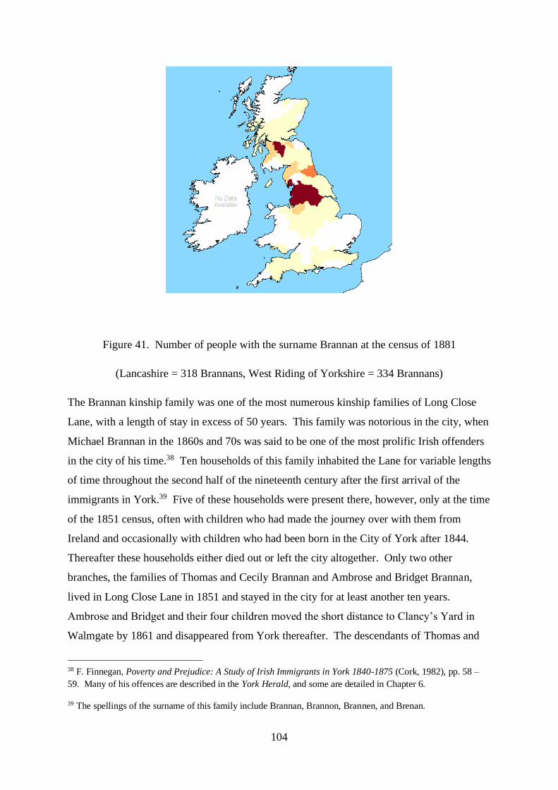
104
Figure 41. Number of people with the surname Brannan at the census of 1881
(Lancashire = 318 Brannans, West Riding of Yorkshire = 334 Brannans)
The Brannan kinship family was one of the most numerous kinship families of Long Close
Lane, with a length of stay in excess of 50 years. This family was notorious in the city, when
Michael Brannan in the 1860s and 70s was said to be one of the most prolific Irish offenders
in the city of his time.38 Ten households of this family inhabited the Lane for variable lengths
of time throughout the second half of the nineteenth century after the first arrival of the
immigrants in York.39 Five of these households were present there, however, only at the time
of the 1851 census, often with children who had made the journey over with them from
Ireland and occasionally with children who had been born in the City of York after 1844.
Thereafter these households either died out or left the city altogether. Only two other
branches, the families of Thomas and Cecily Brannan and Ambrose and Bridget Brannan,
lived in Long Close Lane in 1851 and stayed in the city for at least another ten years.
Ambrose and Bridget and their four children moved the short distance to Clancy’s Yard in
Walmgate by 1861 and disappeared from York thereafter. The descendants of Thomas and
38 F. Finnegan, Poverty and Prejudice: A Study of Irish Immigrants in York 1840-1875 (Cork, 1982), pp. 58 –
59. Many of his offences are described in the York Herald, and some are detailed in Chapter 6.
39 The spellings of the surname of this family include Brannan, Brannon, Brannen, and Brenan.

105
Cecily, however, continued to live in Long Close Lane or streets nearby until at least the
census of 1911. The 20 descendants of this couple spanned four generations. Three of their
children arrived with them from Ireland, but their other two offspring and all the remaining
grandchildren and great grand-daughter were born in York. Each household of this large
family lived at a different address in each census, but all stayed within Long Close Lane or
streets nearby in Walmgate.
Three other households of the Brannan family arrived in the Lane in the decades after 1851,
the adults having been born in Ireland. James Brenan and his sister had arrived by 1861,
along with their neighbours Michael Brennan and his wife Catherine. Michael was
accompanied by his brother, and his two children were born after the family’s arrival in York.
Michael and Catherine and their extended family remained in the Lane until after 1871.
Thomas and Kate Brannon had arrived in Lewis Yard, Long Close Lane by 1891, having
travelled from Ireland to Goole, Leeds and Hull before York, where their children had been
born. At least one of their offspring, Mary, survived to leave the city and travelled to Wigan
then Normanton by 1911, where she had married Patrick Brannon, potentially a cousin.
The Calpin Family
The number of Calpins in the census of 1881 is depicted below in Figure 42.40 As with the
number of Brannans, the Calpins were concentrated to an extent in Lancashire, around the
port of entry from Ireland into Liverpool. The greatest number of individuals with the
surname Calpin at this time, however, was present in the City of York.
40 The key to the colours is: Dark brown = 21-30 people, orange = 11-16 people, light brown = 6-10 people,
yellow = 1-5 people.

106
Figure 42. Number of people with the surname Calpin at the census of 1881
(Lancashire = 21 Calpins, West Riding of Yorkshire = 11 Calpins, York = 45 Calpins)
The Calpin kinship family of the streets of Walmgate in the nineteenth century descended
from a common ancestor in County Mayo.41 Two sons of this ancestor, James and Patrick, in
turn fathered sons in Ireland who arrived in Long Close Lane and Hope Street over the course
of the second half of the nineteenth century. Patrick himself also seemingly travelled to
York, since he took a second wife and had a third son by her born in the city. James’ two
sons arrived with their Irish wives in adjacent houses in Long Close Lane by 1861, and
fathered numerous children there. One of these sons left the Lane for a nearby street in 1871
but had returned within the decade. The other son, Michael, remained as household head in
several different houses along Long Close Lane and Hope Street for at least a further 40 years
until the end of the century. Indeed his children remained in the neighbourhood of these two
streets for the same period of time, occasionally leaving only to return at a subsequent census,
occasionally moving only a few doors down the street, and occasionally living in a house
only a few yards away from their siblings or parents.
41 The genealogies of the Calpin family have been taken from census enumerations and an unpublished book:
Calpin, The Calpins of York.

107
Two of Patrick’s sons and a grandson (Farroll) arrived in this neighbourhood before 1861 or
in the 20 years thereafter, and again had several children born in York. These families too
tended to remain in the neighbourhood until at least 1900, and to flit locally between houses
along the streets. A further member of this family, John Calpin, visited Long Close Lane
having been born in Durham, to live in the same house as Farroll at the census of 1881. Two
other Calpins of unknown lineage with the rest of the kinship family lived in yards off the
Lane and the Street for brief periods of time towards the end of the century.
In summary this section has plotted the arrivals and some aspects of the life cycles of some
Irish kinship families in two streets of Walmgate in York. Hope Street attracted more
isonymic families over the half century, and Irish kinship family head arrivals peaked in
Long Close Lane in 1851. Families, and particularly those of Irish extraction, showed
transience and mobility in their occupation of houses. They tended regularly to move to a
different house in the same street, occasionally to leave their street and subsequently return,
and occasionally to live in a separate house only a few yards away from their siblings or
parents. Two of the largest kinship families of this neighbourhood, the Brannans and the
Calpins, had moved inland from their port of entry from Ireland and established complex
lineages that remained in the city until the end of the century and beyond.
How migrant families in Holgate and Walmgate in York compare with migrant families from
Swaledale, and how the study of these kinship families in urban and rural settings sheds light
on the research questions posed in the Introduction, are discussed in Chapters 6 and 7 of this
thesis.

108
Chapter 4
Surname Indices and Migration: Kinship Families of Swaledale
The previous chapter explored demographic change and surname indices in the urban setting
of Victorian York. This chapter turns for comparison to some indices of demographic change
and the fate of kinship families in nineteenth-century Swaledale.1 The map below (Figure
43) shows the four rural districts, and the villages and hamlets of the dale, located for the
most part along the banks of the river Swale and its tributaries.
Figure 43. The four districts, villages, hamlets and River Swale in Upper Swaledale
The villages of Muker, Gunnerside, Reeth, Grinton and Arkle Town are shown as red ovals,
and the hamlets as asterisks. (Redrawn from the OS map of Swaledale 1856-7, original scale
six-inch to the mile (1:10,560))
1 The data for all the indices relating to urban York and Swaledale collected from the decennial censuses and
parish baptismal registers are presented in Appendices 1, 2 and 3.

109
Surname Indices
The maximum population of Swaledale was 7480 people in 1821, representing at that time a
growth in numbers of about 30% since the beginning of the century (Figure 44). The
development of lead mining had stimulated rapid in-migration. The decline in numbers after
mid-century was continuous and severe. Muker lost a quarter of its population in the 1850s,
and Melbecks and Arkengarthdale over a half between 1871 and the turn of the century.2
Figure 44. Total population of Swaledale and surname indices during the nineteenth century
The catastrophic effects of the collapse of the lead mining industry upon families in the dale
are reflected in the surname indices plotted for the total population in the second half of the
nineteenth century (Figure 44). The population declined as the industry collapsed, while the
surname index rose steeply. In fact, the number of surnames fell over time, but
proportionally less than the fall in the number of people. In other words, entire groups of
isonymic people disappeared from the dale (either by migration or extinction), but their loss
2 R. Fieldhouse and B. Jennings, A History of Richmond and Swaledale (1978, Chichester, 2005), p. 231.

110
was overshadowed by isonymic groups who remained.3 Of the 279 surnames in Swaledale
held by household heads in the census of 1841, 134 had gone by 1901.4
The fortunes of kinship families (as defined in the terms of this thesis) are seen in the
surname indices derived from household heads throughout the decennial censuses of the four
individual districts of Swaledale (Figures 45 to 48). As with the indices plotted for the
population as a whole, the linkage exists between the size of the adult population and the
density of kinship heads. A clear relationship exists between the decline in the adult
population and the diminution or migration of kinship heads in all these communities.
In Muker district, the fall in the adult population in the second half of the nineteenth century
was continuous. The population halved over this period. The changes in surname indices
followed this same pattern, but the overall trajectory was reversed. There was no abrupt
change in population, and it is difficult to attribute these persistent trends to economic
depressions or the collapse of individual mines. The gradients of surname index and
population flows were muted, however, in comparison with the other three districts.
3 The surname indices in Figure 44 are derived from the census data of the total population (CSI(T)). A rise in
this index implies a decreased proportion of kinship families in the entire dale’s community. Although rising,
the SI remains low (maximum 10.7 in 1901), however, indicating that kinship families dominated the
community throughout the century despite their dwindling numbers. Surname indices of the Swaledale
populations are lower than the corresponding indices of the populations of Holgate and Walmgate in York
because there were fewer surnames relative to the number of people. The surname indices in Figures 45 to 48
are derived from the census data of household heads (CSI(H)). The y-axes of these graphs are drawn at the
same scales in all four to allow ease of comparison.
4 There were 279 surnames in the Swaledale census of 1841, and 206 in the census of 1901, ie there was a net
fall of 73 surnames (or 26%). Of the 279 surnames present in the census of 1841, 145 remained in 1901; there
were 61 surnames present in the census of 1901 that had not been present in the census of 1841.

111
Figure 45. Adult population and surname indices of Muker
Figure 46. Adult population and surname indices of Melbecks

112
Figure 47. Adult population and surname indices of Arkengarthdale
Figure 48. Adult population and surname indices of Reeth
In Melbecks and Arkengarthdale districts, on the other hand, the adult populations declined
gradually until the 1870s, and then began a precipitous fall. At the same time the surname
indices altered course. In Reeth district, this pattern was repeated but over a different
timescale. The adult population of Reeth began its decline after 1851, and at the same time
the surname index derived from household heads rose steeply. In these dwindling
communities entire groups of heads of household with the same surname (or kinship families)
disappeared from all four districts of the dale during the second half of the nineteenth
century. The number of surnames of these heads tended to fall over time at a slower rate than
the decline in the total number of heads. In other words, the size of these groups of isonymic

113
heads became relatively smaller as the century progressed. Put more succinctly, it was the
relatively large kinship families that tended progressively to depart from the dale.
The plots of the population of the four districts of Swaledale against the number of
households in the communities show that the steady decline in the population size in all these
areas is attributable to a matching decline in the number of households (Figure 49).
Figure 49. Total populations and number of households in the four districts of Swaledale
However, the mean household size of the remaining families in all four districts also fell in
line with the declining population size (Figures 50 to 53).5 The number of adults in these
households remained more or less constant throughout the second half of the century, and the
declining household size was caused by a fall in all four districts in the number of children
living in the households.
5 The number of households in a population, the mean household size (MHS) and average number of adults
(APH) and children (CPH) per household are calculated from the data used to produce surname indices (see
Chapter 2).

114
Figure 50. Total population, mean household size, and average number of adults and
children per household in Muker
Figure 51. Total population, mean household size, and average number of adults and
children per household in Melbecks
Figure 52. Total population, mean household size, and average number of adults and
children per household in Arkengarthdale

115
Figure 53. Total population, mean household size, and average number of adults and
children per household in Reeth
In the light of these data and trends, it is possible to speculate on the fate of kinship families
in the dale as the population fell during the mining collapse. The declining population may
be accounted for by migration, reduced fertility, or excess mortality, or a combination of
these factors. Some migration of entire families of the same shared surname across
Swaledale, coupled with a fall in the birth rate of those families that chose to remain, would
be one explanations of the findings. Most of the out-migration occurred in the period 1880 –
83, a decade or two after the surname index began to rise.6 An alternative explanation of
kinship decline therefore is that diminished fertility reduced family sizes and the number of
potential kinship family household heads in the succeeding generations. How the exodus or
stagnation of families affected community in the dale is explored in the final two chapters of
this thesis.
Fathers’ Surname Indices
Fathers’ surname indices provide an assessment of men who fathered children that were
related by kin. These indices calculated from the surviving baptismal records of some
Anglican and Nonconformist churches in Swaledale are shown in Appendix 2 and Figures 54
to 57, and the average number of baptisms per father calculated from these data is shown in
Figure 58.
6 Fieldhouse and Jennings, History of Richmond and Swaledale, p. 231.

116
There tend to be inverse correlations between the number of fathers and the fathers’ surname
indices in all the Anglican and Nonconformist registers, but the nature of that inverse
relationship varies. In the Anglican Churches of Muker, Arkengarthdale and Grinton, the
number of fathers remaining in the dale fell over most of the time periods, but the fathers’
surname indices rose. This implies that fathers were drawn increasingly from a diminishing
number or sizes of kinship (or isonymic) families. On the other hand, in the two
Nonconformist congregations of Reeth, the fathers’ surname indices fell over most of the
century while the number of fathers rose, suggesting that the expanding number of fathers
came increasingly from larger or more numerous kinship (or isonymic) families.
Furthermore, the index in each of these congregations was about the same value (50) around
the year 1861. In other words, the number of fathers in each cultural group was roughly the
same at this time in relation to the number of surnames of fathers. There was then no clear
difference in this behavioural characteristic of Anglican or Nonconformist fathers related by
kin. However, the indices in these two religious groups were moving in different directions
at that time, and there is some evidence of an evolving cultural distinction (or fertility
difference) between denominations. Religious belief or conviction may have influenced
sexual activity between fertile couples.
The average number of baptisms per father also show a variable pattern in these
congregations. Baptisms per father tended to decrease in the first half of the century and
increase in the second half in the registers of Arkengarthdale, Grinton and Reeth, and the
converse seems to have occurred in the register of Muker.
Figure 54. Number of fathers and fathers’ surname indices of St Mary Church, Muker

117
Figure 55. Number of fathers and fathers’ surname indices of St Mary Langthwaite,
Arkengarthdale
Figure 56. Number of fathers and fathers’ surname indices of St Andrews Church, Grinton

118
Figure 57. Number of fathers and fathers’ surname indices of Reeth Congregational Church,
and Reeth Wesleyan Methodists Church
Figure 58. Average number of baptisms per father in Swaledale parishes
Memorial Surname Indices
Memorial surname indices provide an assessment of the memorialisation of people in a
graveyard that were related by kin. These indices were derived from the names of people
engraved on the surviving gravestones of the three Anglican churchyards and two of the
Nonconformist chapels of Upper Swaledale.7 The surnames and forenames of all adults and
7 The memorial inscriptions were transcribed by members of the Cleveland, North Yorkshire and South Durham
Family History Society in the 1970s to the 1990s and published on CD, from which the surname indices have
been calculated. The legible names of all people on surviving gravestones in the graveyards whose deaths are

119
children who had died in the nineteenth century and whose names were legible on these
stones were taken from transcripts. The index relates the number of surnames divided by the
number of people, and as with other indices calculated in this thesis, gives a measure of the
density of kinship (or isonymic) families buried in the churchyard. The lower the index
recorded, the greater is the density of shared surnames or kinship families.8
The details of these inscriptions and the surname indices are shown in Table 6 and Figure 59
below.
Anglican Churches Nonconformist Chapels
St Andrew
Grinton
St Mary
Langthwaite
St Mary
Muker
Wesleyan
Methodist
Chapel
Gunnerside
Low Row
Wesleyan
Methodist
Chapel
Memorial Surname
Index
18.8 22.3 18 22.4 25.7
Number of surnames 74 56 51 39 29
Number of people
memorialised
393 251 283 174 113
Total number of
legible gravestones
144 98 102 73 44
Commonest
memorialised
surname
Alderson
21; White
21
Alderson 22 Alderson 51 Woodward 12 Spensley 19
Number of stones
bearing commonest
surname
Alderson 9;
White 4
Alderson 9 Alderson 18 Woodward 4 Spensley 8
Table 6. Memorial surname indices and inscription data of gravestones in Swaledale
memorialised between 1800 and 1900 were used. Inscriptions recorded within the churches or chapels
themselves were not used. The three Anglican churches are St Mary, Langthwaite in Arkengarthdale, St
Andrew, Grinton in Reeth, and St Mary, Muker. The two nonconformist chapels are the Wesleyan Methodist
Chapel, Gunnerside in Melbecks and the Wesleyan Methodist Chapel, Low Row in Melbecks. Other
graveyards in the dale were not included because they contained very few surviving stones from the nineteenth
century, namely Arkletown (which was abandoned when a landslide removed the church), Holy Trinity in
Melbecks, Keld Independent Chapel in Muker, and Reeth Congregational Chapel.
8 The theoretical objections to memorial surname indices, and the justification for including them in this thesis,
are outlined in Chapter 2.

120
Figure 59. Memorial surname indices of gravestones in Swaledale
The graveyards of the Anglican churches in Swaledale in the nineteenth century were larger
than the Nonconformist graveyards. Just as was found in the rural parishes of Bolton Percy
and Poppleton in Chapter 2 of this thesis, there is also a clear inverse correlation between
surname indices and the size of these graveyards. In other words, the larger the graveyard,
the lower is the surname index of the memorial inscriptions and the greater is the density of
kinship family surnames. Whether these kinship families had Anglican or Nonconformist
leanings, they tended to bury their dead in the larger Anglican churchyards. The Alderson
family, the most numerous family in Swaledale both at the start and end of the period of
study, were also the most numerous in the Anglican burial grounds. On the other hand, the
two families memorialised most commonly in the Nonconformist graveyards, the Woodward
and the Spensley families, do not appear high in the order of large kinship families in
nineteenth-century Swaledale.9 As with the divergent attitudes or behaviour of fathers related
by surname or kinship seen with the fathers’ surname indices, so there was a cultural or
religious difference in the manner in which Anglicans or Nonconformists in Swaledale
remembered their dead.
Kinship Families
The histories of five of the largest nineteenth-century kinship families of Swaledale, the
Alderson, Harker, Metcalfe, Peacock and Raw families, are detailed in this section, in an
9 The Spensley family were said to be John Wesley's hosts during his visits to the dales: E. Cooper, Muker: The
Story of a Yorkshire Parish (Clapham, 1948), p. 42. The prominence of this family was also noted by Speight:
H. Speight, Romantic Richmondshire (London, 1897), p. 270.
15
17
19
21
23
25
27
29
Surn
ame
Index
Number of people memorialised
St Andrew Grinton
St Mary
Langthwaite
St Mary Muker
Wesleyan Methodist
Chapel Gunnerside
Low Row Wesleyan
Methodist Chapel

121
attempt to show how their trajectories differed from each other and varied between the
districts of Muker, Melbecks, Arkengarthdale and Reeth.10
Figure 60. The four districts, villages, River Swale and main mines in Upper Swaledale
Mines: BH – Beldi Hill; S – Swinnergill; L/B – Lownathwaite/Blakethwaite; OG/S – Old
Gang/Surrender; A – Arkengarthdale. Lines in mining areas denote major veins or levels and
small asterisks denote smelt mills. (Redrawn from the OS map of Swaledale 1856-7, original
magnification six-inch to the mile (1:10,560))
The Swaledale lead mines (Figure 60) enjoyed great prosperity in the mid-nineteenth century,
succeeded by a severe depression, decline then extinction of the industry in the early years of
the twentieth century. The most profitable and resilient mine, the Old Gang, was developed
10 All five of these families were present in Upper Swaledale in preceding centuries also. See for example North
Yorkshire C.R.O., Swaledale Manor records ZA (MIC 144-9, 166-7, 998, 1007-9, 1046, 2476). Aldersons were
noted by Whitaker in 1823 (T.D. Whitaker, An History of Richmondshire (London, 1823), p. 310), and the
derivation of the name Harker from Harkaside near Reeth by Speight in 1897 (Speight, Romantic
Richmondshire, pp. 250 & 271).

122
by the Pomfret-Denys family, and the rest let off to lessees.11 Two entrepreneurial London
lead merchants, George and Thomas Alderson, bought the lease of the Old Gang mine in
Melbecks district in 1811.12 For a time this venture was successful. New developments
proved to be an excessive drain on capital, however, and the Aldersons gave up the lease of
the Old Gang mine in 1828. The Jacques family bought the lease and reaped the benefit of
the former owners’ significant investment. The mine made handsome profits until 1874.
The men who extracted the ore from Swaledale mines came originally from farming families,
and their involvement in the industry eventually overshadowed agriculture. Swaledale
farmers in the middle of the seventeenth century began to engage in part-time mining, and
within the next century their descendants were miners who engaged in part-time farming.13
Those farming communities within which lead mines were opened were transformed into
communities of miners, many of whom held small plots of land. Hallas has catalogued these
changes in the economy of the Pennine dales.14 She has shown that the Melbecks and
Arkengarthdale regions of Swaledale experienced a considerable influx of migrants at the end
of the eighteenth century and in the first decade of the nineteenth. Those miners already
established when the immigrants arrived retained their smallholdings. However, most of the
immigrants would have been unable to rent a holding of land. The Yorkshire lead mining
area experienced an increase in population of about 30% between 1801 and 1821. In
Arkengarthdale, the population increase of 30% between 1801 and 1811 is attributed to an
influx of mineworkers from the agricultural districts of the North Riding and South Durham.
About one half of the workforce in Swaledale was employed by the lead mining industry in
1851. This proportion fell progressively and was about 20% in 1891 by which time Hallas
argues that agriculture had once again become the largest employment.
11 Leases were first taken out around the start of the nineteenth century by partnerships in Wensleydale,
Newcastle, Stockton and London: Surrender mine in 1792, the Arkengarthdale field in 1800, Swinnergill mine
in 1804, Beldi Hill in 1808, Blakethwaite in 1806 and Lownathwaite in 1812 (Fieldhouse and Jennings, History
of Richmond and Swaledale, pp. 207-208).
12A. Raistrick and B. Jennings, A History of Lead Mining in the Pennines (London, 1965), pp. 257-264 and 206.
13 Raistrick and Jennings, A History of Lead Mining, pp. 311–324.
14 C. Hallas, Rural Responses to Industrialization: The North Yorkshire Pennines 1790-1914 (Bern, 1999), pp.
21-23. Hallas lists 1343 employees in Swaledale in the ‘extractive’ industries (lead, coal and quarrying
industries), or 49.4% of the workforce, in 1851; and 289 or 22.2% workers respectively in 1891. Corresponding
figures for agricultural workers were 531 (19.5%) in 1851 and 660 (50.7%) in 1891.
123
The population trends in Swaledale reflect the people's reliance upon, and balance between,
the lead mining industry and farming. In the early years of the nineteenth century, the
greatest growth in population occurred in townships with a substantial lead industry;
similarly, the most severe losses in the second half of the century occurred in those townships
where the lead industry had been most influential. The population changes thus varied
considerably between townships. The entire dale suffered severe difficulties following the
near total collapse of its lead industry towards the end of the nineteenth century, and a
proportion of the population left the dale. It was the strength of its underlying agricultural
base, Hallas maintains, which enabled the economy to survive.15
These changes in population affected kinship families across the dale. As the population fell
precipitously after 1861, so the surname index rose steeply and progressively. This rise in the
index implies a rise in the number of surnames relative to the size of the population, or a rise
in the density of smaller families with few isonymic heads of household. Small families grew
as the lead-mining industry collapsed in the second half of the nineteenth century and at the
expense of larger kinship families. The surname indices of the period show, in other words,
that larger kinship families became depleted over this period. This fall in their concentration
arose presumably either because they migrated in preference to smaller families, or they
experienced reduced fertility, or a combination of the two. It is possible to look in more
detail at the movement within and from the dale of these kinship families by a simple count
of the household heads of any particular surname at each of the decennial censuses. Having
identified the household heads of the family by forename, the genealogical descent of
individual household heads and their occupations by district of residence in Swaledale can be
confirmed and plotted.
Counts of household heads of Swaledale kinship families are presented in Appendix 11. This
shows the list of Swaledale families with the greatest overall changes in number between
1841 and 1901, tabulated as the number of household heads in each family taken from the
census returns. There were 16 families with a decline of at least ten household heads, and 11
families with a growth of at most four heads. The fall in the number of households of these
16 largest kinship families in Swaledale was constant and relentless, notably by more than a
15 Hallas, Rural Responses to Industrialization, p. 44. This author concludes that it was the diversity of
occupations within the rural economy of Swaledale, with resilient supporting crafts and services, that enabled
the community to survive the collapse of its lead industry. See also: C. Hallas, ‘Craft occupations in the late
nineteenth century: Some local considerations’, Local Population Studies, 44 (1990), pp. 22 – 28.
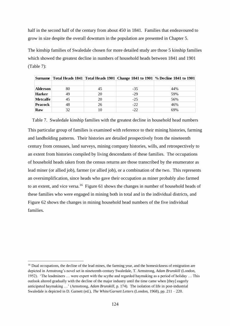
124
half in the second half of the century from about 450 in 1841. Families that endeavoured to
grow in size despite the overall downturn in the population are presented in Chapter 5.
The kinship families of Swaledale chosen for more detailed study are those 5 kinship families
which showed the greatest decline in numbers of household heads between 1841 and 1901
(Table 7):
Table 7. Swaledale kinship families with the greatest decline in household head numbers
This particular group of families is examined with reference to their mining histories, farming
and landholding patterns. Their histories are detailed prospectively from the nineteenth
century from censuses, land surveys, mining company histories, wills, and retrospectively to
an extent from histories compiled by living descendants of these families. The occupations
of household heads taken from the census returns are those transcribed by the enumerator as
lead miner (or allied job), farmer (or allied job), or a combination of the two. This represents
an oversimplification, since heads who gave their occupation as miner probably also farmed
to an extent, and vice versa.16 Figure 61 shows the changes in number of household heads of
these families who were engaged in mining both in total and in the individual districts, and
Figure 62 shows the changes in mining household head numbers of the five individual
families.
16 Dual occupations, the decline of the lead mines, the farming year, and the homesickness of emigration are
depicted in Armstrong’s novel set in nineteenth-century Swaledale, T. Armstrong, Adam Brunskill (London,
1952). ‘The leadminers … were expert with the scythe and regarded haymaking as a period of holiday … This
outlook altered gradually with the decline of the major industry until the time came when [they] eagerly
anticipated haymaking …’ (Armstrong, Adam Brunskill, p. 174). The isolation of life in post-industrial
Swaledale is depicted in D. Garnett (ed.), The White/Garnett Letters (London, 1968), pp. 211 – 220.
Surname Total Heads 1841 Total Heads 1901 Change 1841 to 1901 % Decline 1841 to 1901
Alderson 80 45 -35 44%
Harker 49 20 -29 59%
Metcalfe 45 20 -25 56%
Peacock 48 26 -22 46%
Raw 32 10 -22 69%

125
Figure 61. Combined numbers of mining household heads of 5 families in Swaledale
districts between 1841 and 1901.
Figure 62. Numbers of mining household heads of 5 individual families in Swaledale
between 1841 and 1901.
From a total of 112 household heads employed in mining in 1841, the collapse of the industry
in these families was almost total by 1901. Melbecks and Arkengarthdale had a significantly
larger number of mining households than Reeth or Muker districts at the start of the period.
The slowest rate of collapse in the industry in these kinship families occurred in Melbecks,
and the collapse occurred earlier in Arkengarthdale and Muker than in the other two districts.
Indeed in Reeth there was initial growth in the number of mining households until 1861, after
which the collapse was complete within the next 30 years. With regard to the individual
mining families, the decline in the Alderson household head numbers was relentless over the
half century. The Metcalfe miners were resistant to collapse until the 1860s. With the

126
exception of the Aldersons, these families showed some resurgence in mining in the 1860s
and 1870s, but thereafter the downturn was steep as the mines entered their terminal phase.
The fortunes of these five families were more buoyant in the dale in the agricultural
economy. The numbers of their farming heads of household are shown combined in the
districts and individually across the entire dale in Figures 63, 64 and 65.
Figure 63. Combined numbers of farming household heads of 5 families in Swaledale
districts between 1841 and 1901.
Figure 64. Numbers of farming household heads of 4 individual families in Swaledale
between 1841 and 1901.

127
Figure 65. Numbers of farming household heads of the Harker family in Swaledale between
1841 and 1901.
Few men of these families farmed in Arkengarthdale in this period. All of the other three
districts, however, showed an increase in the number of farming household heads between
1841 and 1901, albeit with some fluctuations in numbers over the decades. There was a
general slump in the number of farming households of these kinship families across the dale
in the 1850s and 1880s, but a growth in their numbers in the other four decades of the second
half of this century. These trends reflect the fortunes of four of the five chosen kinship
farming families, namely the Alderson, Metcalfe, Peacock and Raw families. The remaining
family, the Harkers, showed a largely static number of farming heads of household across the
half century.
The fates of these mining and farming families across Swaledale as a whole and their
individual trajectories in the four separate districts are detailed now. Some distinct patterns
and distinctions become apparent. The plots of three of these families, namely the Aldersons,
Harkers and Metcalfes, are presented in Appendices 12, 13 and 14. These show the family
members, their dates and places of birth, and their residence and occupation at each of the
censuses. The plots of total number of heads of household of each of the five families, and
the number of men employed in farming and lead mining at each census year and in each
district, are summarised and plotted in Appendix 15. Illustrative examples of these plots are
also included in this chapter.

128
The drain of kinship families was gradual but sustained from Muker district. There was no
abrupt exodus from any point in time. Farming was quite clearly the mainstay of the
economy in this district. The leases of the Swinnergill, Lownathwaite and Blakethwaite
mines ran until 1867 and work stopped in 1861.17 Mining households largely disappeared
after this year, but farming households persisted in all five families until at least the turn of
the twentieth century. Two patterns emerge in farming families in Muker, namely one of
stability in the number of farmers in the families across the period, and the other of growth in
number (defined as a higher peak in the final quarter of the century than in the third). The
Alderson and Peacock farmers showed some growth in Muker, although the Aldersons
always outnumbered the Peacocks. This district was the only region of the dale in which the
Alderson economic survival was dominated by farming (Figure 66). Muker, the furthest
reach of the upper dale and the most isolated, housed about half of the total Alderson family
of the whole dale in 1841. Half of the Alderson heads of Muker were farmers and/or
landowners at that time, and only about a quarter were employed in the lead mining industry.
None of the heads of Alderson families of 1841 chose to move their household to any other
district of Swaledale for the remainder of their lives. In fact, the majority of these farmers in
Muker continued to survive from agriculture for at least ten years after 1841, and some
continued to farm until well into the second half of the nineteenth century. One Muker
farmer, John Alderson of Thorns born in 1816 in the hamlet of Keld, remained as a head of
household in his occupation in 1841 for the longest period of time of any Alderson in
Swaledale, initially as a landowner farming in excess of 100 acres.18 Throughout this period
in Muker, the numbers engaged in farming remained high and peaked in the last quarter of
the century. The lead mining community, by contrast, collapsed in this district after 1841.
Only two lead miners survived in the industry as a head of household until the next census,
and a further two combined mining with farming for a time before becoming full-time
farmers.19 Those men engaged in the lead mining industry fell in number rapidly between
17 Fieldhouse and Jennings, History of Richmond and Swaledale, pp. 220-222.
18 The life of the fourth child of John and Mary Alderson, Elizabeth, is described in Those Who Left the Dales
(E. Peacock and Y. Alderson, ‘Elizabeth Alderson from Swaledale to the homes of the nobility and finally back
to Muker’, in Marriott, Those Who Left the Dales, p. 70. She entered into high domestic service, in the
employments of the Countess of Sandwich in Huntingdon, the Duke of Beaufort in Badminton, and Lord Derby
at Knowsley Hall in Lancashire. She returned to Muker churchyard for burial.
19 The proportion of the workforce in Swaledale with a dual occupation varied between censuses, but more than
doubled between 1851 and 1891 (Hallas, Rural Responses to Industrialization, p. 43). This reached a peak of
181 mine workers in agriculture in 1871, when 117 miners recorded a second occupation in farming. Very few

129
1841 and 1871, after which Alderson lead mining families existed no more in Muker. Their
demise predated the growth in farming, albeit not enough to halt the overall decline in the
Alderson family. The Peacock family similarly showed some growth in farming households
in Muker in the final quarter of the century, although even their peak number of farmers in
Muker in 1881 was lower than the smallest number of Alderson farmers at any census.
Figure 66. Occupations of Alderson household heads in Muker district
Three families, namely Harker, Metcalfe and Raw, showed some stability in farming across
the period. The Harker family, although always fewer in number than their Alderson
neighbours in Muker, showed the same attachment to the land (Figure 67). Whereas the
Aldersons declined in number, however, the pool of Harker heads of household remained
more or less the same. Lead-mining Harker families disappeared too, and Harker farmers
maintained their constant number. Several Harker families maintained their lineage
throughout the remainder of the century, and their plots may throw light on inheritance
practices in Muker and social mobility. In these families one son often continued as head of a
farming household when the parent had died or relinquished their hold of a farm. David
Harker (born in 1817) continued his mother’s line in farming and diversified for a time into
innkeeping and lead mining. He retired as a farmer, two of his sons following his occupation
but only one after the other. William (born in 1805) survived as a lead miner and farmer, his
widow maintaining a farm for at least twenty years after his death. Their son took over the
Alderson households in the dale in 1841 subsequently combined farming and lead mining, the majority of
household heads that remained in further censuses subsisting from their original occupation.
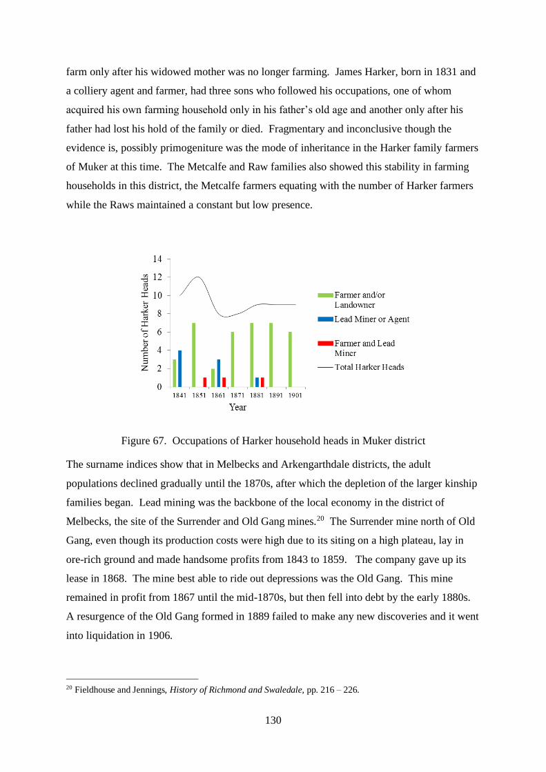
130
farm only after his widowed mother was no longer farming. James Harker, born in 1831 and
a colliery agent and farmer, had three sons who followed his occupations, one of whom
acquired his own farming household only in his father’s old age and another only after his
father had lost his hold of the family or died. Fragmentary and inconclusive though the
evidence is, possibly primogeniture was the mode of inheritance in the Harker family farmers
of Muker at this time. The Metcalfe and Raw families also showed this stability in farming
households in this district, the Metcalfe farmers equating with the number of Harker farmers
while the Raws maintained a constant but low presence.
Figure 67. Occupations of Harker household heads in Muker district
The surname indices show that in Melbecks and Arkengarthdale districts, the adult
populations declined gradually until the 1870s, after which the depletion of the larger kinship
families began. Lead mining was the backbone of the local economy in the district of
Melbecks, the site of the Surrender and Old Gang mines.20 The Surrender mine north of Old
Gang, even though its production costs were high due to its siting on a high plateau, lay in
ore-rich ground and made handsome profits from 1843 to 1859. The company gave up its
lease in 1868. The mine best able to ride out depressions was the Old Gang. This mine
remained in profit from 1867 until the mid-1870s, but then fell into debt by the early 1880s.
A resurgence of the Old Gang formed in 1889 failed to make any new discoveries and it went
into liquidation in 1906.
20 Fieldhouse and Jennings, History of Richmond and Swaledale, pp. 216 – 226.

131
Mining overshadowed farming in Melbecks. Two patterns of mining households emerge
again in the five largest kinship families in the dale. The dominant pattern is seen in four of
the families (namely Alderson, Harker, Metcalfe and Raw), in which there was a stable
number of miners until 1861 or thereabouts, after which the numbers fell away. Whilst the
Aldersons and Harkers both followed this pattern, they show an interesting contrast after the
mine began to fail (Figures 68 and 69). The overall numbers of these two family heads in
Melbecks district were similar in scale, but their tendencies to remain in the dale or dissipate
appear to be polar opposites. Farming households account for this difference. As the total
adult population fell over the second half of the nineteenth century, the number of Alderson
households rose and the number of Harker households fell in Melbecks. Farming before the
collapse of the local lead mine in Melbecks occupied one Alderson household. With the
decline of the mining community, Aldersons increasingly supported their families from the
land, but the slow demise of mining Harker families in this district was not compensated by
farming. Some Harker families after 1871 farmed the land or combined this with lead
mining, but the fall in Harker numbers continued. In fact, of the five branches of the Harker
family occupied in lead mining in Melbecks in 1871, seven members or their offspring
diversified into farming but of these, four farmed further up the dale in Muker. Melbecks
also did not show the same stability of Alderson families as was seen in Muker. Whereas
most of the heads of Alderson households in Muker survived in the dale for at least another
ten years after the census of 1841, including the lead miners, none of the Melbecks lead
miners’ households of 1841 was still there in 1851. In conclusion the Aldersons in Melbecks
were able to diversify into farming after the Old Gang mine failed, but the Harkers could not
(Figure 70).21 Individual long-standing Harker family mining households may have
experienced inflexibility or inexperience in switching to agriculture. Perhaps landowning
patterns, inheritance practices or family structures adopted by the Aldersons gave them this
resilience or persistence.
21 Photograph courtesy of Masham Photographic Club

132
Figure 68. Occupations of Alderson household heads in Melbecks district
Figure 69. Occupations of Harker household heads in Melbecks district

133
Figure 70. Ruins of the Old Gang Smelt Mill, Melbecks Moor
The Metcalfe and Raw families showed the same early stability in mining households in
Melbecks followed by a decline. The Peacock family, however, bucked the trend of their
neighbours in this district. While neighbouring kinship mining families went into decline in
the third quarter of the century, the Peacock miners actually grew in number, reaching their
peak in 1871 (Figure 71).
Figure 71. Occupations of Peacock household heads in Melbecks district
There are differences again in the fate of these families in Arkengarthdale, the most rugged
and inhospitable terrain of the four districts of Swaledale. As in neighbouring Melbecks, the
mainstay of the local economy was the mining industry. These mines fared better than mines
elsewhere in Swaledale after 1870, when valuable new discoveries were made in

134
Arkengarthdale. Output faltered after the mid-1880s.22 Patterns also emerge within and
between the fortunes of the local families. Two families, the Metcalfes and the Raws, had no
real presence in Arkengarthdale. The numbers of mining households of the other three
families fell progressively over the second half of the century, albeit with the occasional
decade of growth. The decline in Alderson households here was steep and prolonged,
occasioned by a relentless fall in the number of lead-mining households and a somewhat
more stuttering decline in farming households (Figure 72). The Aldersons in this region
faced near extinction by 1901. Their decline in number was more rapid than the depopulation
of the whole community until 1881, after which they both plummeted. The Alderson
households in Arkengarthdale were dominated by lead mining in 1841, but most of them had
left the dale within the next decade. Very few lead-mining Alderson household heads
survived in Arkengarthdale into the 1850s. Thereafter one miner combined his living with
farming, and two took their trade lower down the dale into Reeth well into the second half of
the nineteenth century. One remarkable lead miner, Christopher Alderson, worked into his
70s throughout the collapse in the industry, taking his household between Arkengarthdale and
Reeth. The fate of the Peacock lead miners paralleled that of the Aldersons in the district,
with some resurgence of its farming community towards the turn of the next century.23
Figure 72. Occupations of Alderson household heads in Arkengarthdale district
22 Fieldhouse and Jennings, History of Richmond and Swaledale, p. 226.
23 The Peacock family was said to be an ‘intellectual’ family that had no wish to be involved in mining
(Marriott, Those Who Left the Dales, p. 174). Rees also noted that kin groups in a Welsh parish could have their
collective vices and virtues (A.D. Rees, Life in a Welsh Countryside: A Social Study of Llanfihangel yng
Ngwynfa (Cardiff, 1951), p. 78).

135
The Harker family in Arkengarthdale experienced the same precipitous fall in their number as
the Aldersons in the third quarter of the century, again due largely to the departure of lead
miners (Figure 73). The Harker decline began at least 20 years later than the Aldersons,
however, and came to a halt in the final years of the century. The survival of some farmers
and lead miners avoided the terminal decline seen with the Aldersons. The lead miners who
worked through the final stages of mining in Arkengarthdale were invariably long-established
miners or their sons. These included George and James Harker, brothers and descendants of
a line of local miners, and George and Thomas Harker, both miner’s sons. Arkengarthdale’s
Harker farmers had a slightly more varied background. Two had mining roots, but three
others came from farming stock in Reeth. The arrivals from Reeth in 1901 comprised a 50
year old newcomer and a son and father who had emigrated from a farm there 40 years
earlier.
Figure 73. Occupations of Harker household heads in Arkengarthdale district
Reeth is the most easterly of the four districts of Upper Swaledale. This was a district of
relatively few mines and of lowland pasture. Here there was a mixed economy of industry
and agriculture. The Grinton mines were productive during the first half of the nineteenth
century.24 Once again some patterns emerge in the fortunes of the five kinship families. A
couple of the families showed a growth followed by a slump in the number of mining heads
of household, while the other three showed only a drop in their number over the half century.
Similarly most of these families enjoyed a rise then a drop in the number of farmers. Only
24 Fieldhouse and Jennings, History of Richmond and Swaledale, p. 218.
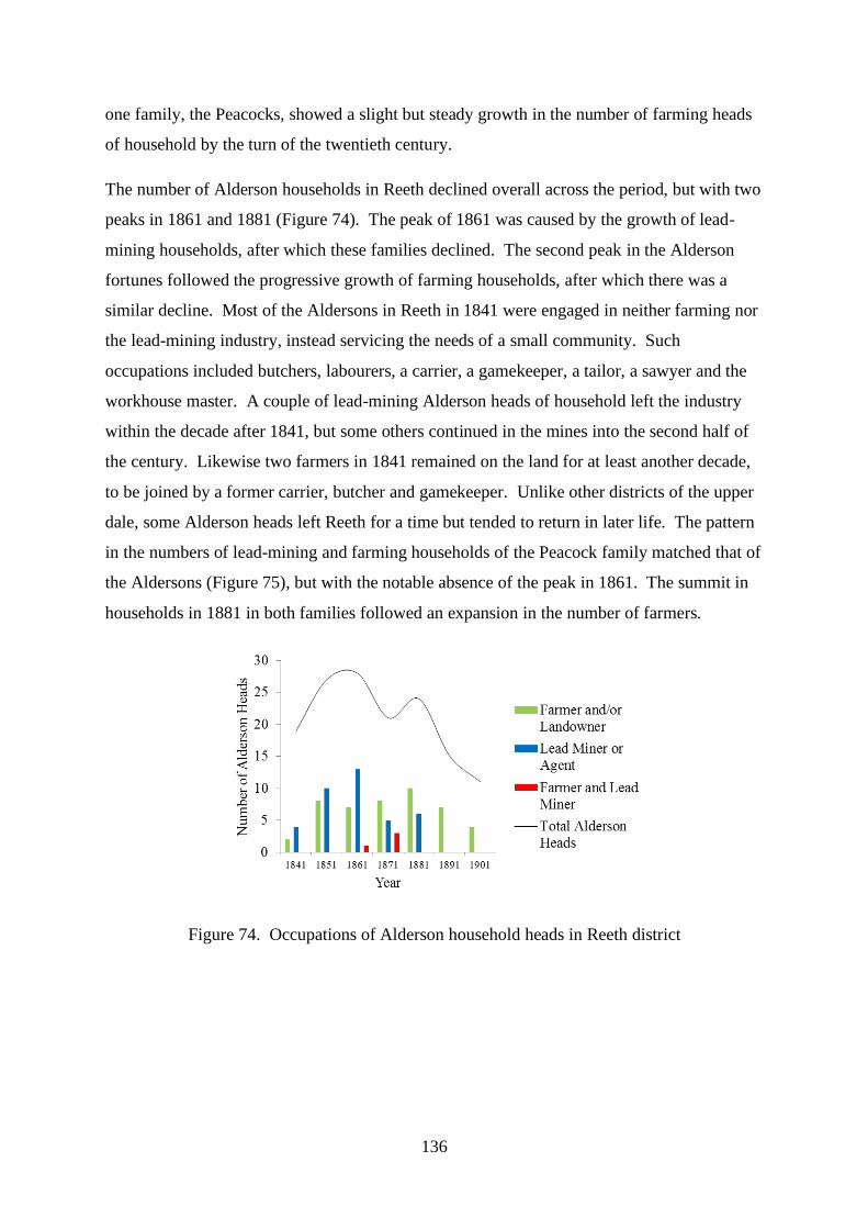
136
one family, the Peacocks, showed a slight but steady growth in the number of farming heads
of household by the turn of the twentieth century.
The number of Alderson households in Reeth declined overall across the period, but with two
peaks in 1861 and 1881 (Figure 74). The peak of 1861 was caused by the growth of lead-
mining households, after which these families declined. The second peak in the Alderson
fortunes followed the progressive growth of farming households, after which there was a
similar decline. Most of the Aldersons in Reeth in 1841 were engaged in neither farming nor
the lead-mining industry, instead servicing the needs of a small community. Such
occupations included butchers, labourers, a carrier, a gamekeeper, a tailor, a sawyer and the
workhouse master. A couple of lead-mining Alderson heads of household left the industry
within the decade after 1841, but some others continued in the mines into the second half of
the century. Likewise two farmers in 1841 remained on the land for at least another decade,
to be joined by a former carrier, butcher and gamekeeper. Unlike other districts of the upper
dale, some Alderson heads left Reeth for a time but tended to return in later life. The pattern
in the numbers of lead-mining and farming households of the Peacock family matched that of
the Aldersons (Figure 75), but with the notable absence of the peak in 1861. The summit in
households in 1881 in both families followed an expansion in the number of farmers.
Figure 74. Occupations of Alderson household heads in Reeth district

137
Figure 75. Occupations of Peacock household heads in Reeth district
The Harkers, a family second in size across the dale as a whole only to the Aldersons at the
start of the period, tended not to inhabit Reeth. Very few of them worked the mines there.
Others were farmers. Although always fewer in number than the Aldersons, their patterns of
growth then decline were similar. Harker farmers began to fail 20 years before the Aldersons
in Reeth and they had all departed by the final ten years or so of the nineteenth century. Only
one of the Reeth farmers of 1861 was also a landowner, and her son was the only offspring
who continued to farm for any length of time in Swaledale. The other Harker farmers of
1861 were either new arrivals or longer standing, and only one was a former miner in Reeth.
*
This chapter has looked in quite some detail at the histories of the largest kinship families in
Swaledale over the course of the nineteenth century, in other words those families with the
most household heads at mid-century. Some patterns have emerged and it is possible to draw
some broad conclusions. As the population of the entire dale dropped, it was the large
kinship families of the community that declined preferentially with the rural exodus. The
largest kinship families dwindled in size and/or chose, or were obliged, to leave. The smaller
families tended to remain in the dale. The demographics of these large kinship families
differed in the various districts of the dale and between each other. Farming dominated the
economy in Muker. The large kinship families here showed stability or growth in number of
household heads. The slow steady decline in population in Muker district can be attributed to
this dependence on agriculture, in contrast to the more pronounced precipitous depopulation
in districts reliant on the fortunes of failing mines. Similarly the rising birth-rate in Muker in
the first half of the century may reflect parental optimism in farming. Lead mining

138
predominated in Melbecks and Arkengarthdale. The majority of the studied lead-mining
kinship families in Melbecks fell in numbers after a period of stability until 1861, but in
Arkengarthdale mining kinship families declined progressively. Neither mining nor farming
held sway in Reeth. Some kinship families enjoyed a boom in both industries in this district,
but followed by a slump, while some witnessed only a steady decline in their mining
fortunes.
It is possible to speculate further on the factors behind these demographic changes, and on
their effects. Lead mining collapsed in Swaledale over the course of the century for the
reasons that many extractive industries tend to fail: exhaustion of its seams, and competition.
As employment in the mines diminished, some families may have had the opportunity, or felt
the economic pressure, to move into farming or increase the sizes of their farms. On the
other hand, men with little or no land may have been forced to emigrate. Migration to other
industrial areas of England or overseas accounts for at least some of the population decline in
the dale, the dispersal of kin family members to a more prosperous future attracting further
waves of family left behind. Falling family size may have produced a similar effect on the
rural population. Deindustrialisation and/or the agricultural slump may have depressed
fertility, depleting the number of offspring available or able to head households, even
rendering some families extinct, and allowing the influx of new isolated families into the
economy.25
Migrant families came from many different strata of Swaledale society, and they left for
different places and for different reasons. Many more migrated to other parts of Britain than
overseas.26 Favoured destinations were Lancashire, the West Riding of Yorkshire, and the
coalmining areas of the North East. There was a strong tradition of currents of migration
between the coal- and lead-mining regions of the dales and the Durham fields, the
movements fluctuating with the fortunes of each industry. Brierfield near Burnley in
Lancashire attracted Swaledale migrants in particular. The number of dales-people living in
Brierfield increased from 62 to 248 between 1851 and 1871, where migrants tended to settle
even in the same streets. A review of the parish of Little Marsden in Brierfield in the census
25 Bogg on his tour of Swaledale in the early twentieth century noted that …‘Today the population of the
countryside answers to not many more than a dozen or two names.’ (E. Bogg, Richmondshire: An Account of its
History and Antiquities, Characters and Customs, Legendary Lore, and Natural History (Leeds, 1908), p.216.)
26 Hallas, Rural Responses to Industrialization, pp. 265 - 294.

139
of 1871 shows that 27 of 197 households were headed by men born in Swaledale. Of these
27 heads of household, 11 were offspring of the Alderson, Harker, Metcalfe and Peacock
families studied in this thesis. Most were concentrated in three streets in the town, and they
were almost exclusively coal miners. Migration to this part of Lancashire gained pace in the
1880s and 1890s. Emigrants from Swaledale sailed particularly for Dubuque on the
Mississippi River in Iowa, attracted by the lead ore, profitable farming opportunities, and
favourably low prices of land, livestock and provisions.27 The boom in mining in Dubuque
was from 1835 to 1849. Immigrant families became integrated over a wide area of the
mining and farming country and individual families, notably the Harker, Peacock and Raw
families, developed their own specific areas of land.28 These newcomers enjoyed political
equality and the opportunity of a better life than in their native land.29
*
The vagaries of the lead-mining industry in the four districts of Swaledale, landholding
patterns and inheritance practices therefore probably go quite some way to explain kinship
family trajectories, as may individual family structures and fertility. The nineteenth century
produced marked changes in the mix of families inhabiting the dale. Rural depopulation
clearly reduced the size of the kin component of the community left behind. The notion of
kinship, however, is much more than family ties that lend themselves to simple arithmetic,
and these profound demographic changes raise other interesting questions. Did, for example,
depopulation diminish or minimize kin (and core) family presence? Or indeed did it
strengthen or enhance their status in the community? These possibilities, together with the
effects of migration of families into the communities in York, are explored in Chapters 6 and
7.
27 C.S. Hallas, ‘Migration in nineteenth-century Wensleydale and Swaledale’, Northern History, 27 (1991), p.
152 and 157.
28 These Swaledale names appear also in the list of burials at the Leadmine Primitive Methodist Church
Cemetery, New Diggings, Lafayette County, Wisconsin (Marriott, Those Who Left the Dales, p. 76).
29 D. Morris, The Dalesmen of the Mississippi River (York, 1989). A map on p. 90 shows the Fever River, a
tributary of The Mississippi, with the names of these settlers and the areas in which they developed their own
land.

140
Before these questions are addressed, however, the thesis turns to the comparison between
the migrant families of York and Swaledale, beginning with some aspects of migration in
different age groups or cohorts of the two populations.

141
Age Cohorts in Migrant Populations
Different cohorts in migrant populations can be tracked across time by means of surname
indices (cohort surname indices). The age cohorts are based in this study on data published
on migration rates in relation to life-course collected from family histories in the period 1850-
1899 by Pooley and Turnbull. Migration according to these authors increased steeply in the
teens and early twenties (17-25) as children left the parental home, remained high for a few
years as marriage, a growing family and new employment prospects stimulated moves, and
then dropped steadily until old age (26-59).30 The cohort surname indices for these age
groups in the six streets in York and in Swaledale are tabulated in Appendix 3 and plotted in
Figures 76, 77 and 78. Figure 76 provides the comparison between the urban and rural
groups, and Figures 77 and 78 show the data for each separately.
Figure 76 shows the cohort surname indices for both York and Swaledale plotted at each
cohort and in the censuses between 1851 and 1901. The surname indices in the Swaledale
populations are consistently less than the indices in the York populations for each cohort
because the number of surnames was always proportionally less than the number of
individuals in Swaledale than in York. An index derived from a young age cohort (children)
tends to be low because several siblings may share the same surname in each nuclear family.
The raised index in the 17-25 year age cohort compared with the 0-16 year age cohort implies
a reduced proportion of isonymic individuals, probably because children had either left the
population or daughters had married and lost their parental surname. The lowered index in
the 26-59 year age cohort compared with the 17-25 year age cohort implies an elevated
proportion of isonymic individuals, probably because of an increased proportion of nuclear
families led by two parents with the same surname. An index derived from an old age cohort
tends to be high because mortality reduces the number of people with shared surnames.
30 C. Pooley and J. Turnbull, Migration and Mobility in Britain since the Eighteenth Century (London, 1998), p.
207.

142
Figure 76. Cohort surname indices derived from York and Swaledale populations between
1851 and 1901
Age Cohorts in York Population
Figure 77. Cohort surname indices derived from populations of streets of Holgate and
Walmgate
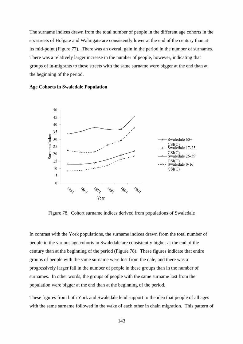
143
The surname indices drawn from the total number of people in the different age cohorts in the
six streets of Holgate and Walmgate are consistently lower at the end of the century than at
its mid-point (Figure 77). There was an overall gain in the period in the number of surnames.
There was a relatively larger increase in the number of people, however, indicating that
groups of in-migrants to these streets with the same surname were bigger at the end than at
the beginning of the period.
Age Cohorts in Swaledale Population
Figure 78. Cohort surname indices derived from populations of Swaledale
In contrast with the York populations, the surname indices drawn from the total number of
people in the various age cohorts in Swaledale are consistently higher at the end of the
century than at the beginning of the period (Figure 78). These figures indicate that entire
groups of people with the same surname were lost from the dale, and there was a
progressively larger fall in the number of people in these groups than in the number of
surnames. In other words, the groups of people with the same surname lost from the
population were bigger at the end than at the beginning of the period.
These figures from both York and Swaledale lend support to the idea that people of all ages
with the same surname followed in the wake of each other in chain migration. This pattern of

144
migration into York and out of Swaledale seems to have gathered pace somewhat across the
half century in a wave or tidal flow.
145
Chapter 5
Persistent Families of York and Swaledale
The previous two chapters of this thesis have tracked migrant people with the same surname
over the course of the nineteenth century in York and Swaledale by means of surname
indices, then explored in some detail individual migrants in these communities who shared an
ancestor. The present chapter moves on to look at the demographic characteristics of people
who persisted in their community for a prolonged period of time. In view of the ability to
track people in the same localised neighbourhood only in the urban context, persistence is
defined in different terms in York and Swaledale. In Holgate and Walmgate heads of
household who lived in the same street for a minimum of ten years are examined, but in
Swaledale those isonymic families whose heads of household grew in number over the
second half of the nineteenth century despite rural depopulation are followed.
Holgate
Families had lived along Holgate Road for more than a century before the arrival of the
railway, but the adjacent square and terraces had been built in the 1860s and 1870s to
accommodate the new railway workforce.1 Holgate Road in the nineteenth century
comprised 35 households in the census of 1841. They more than doubled in number in the
next decade and then remained unaltered until the end of the century. There were numerous
terraces along the road, with a few small courts or yards, St Paul’s Church and Rectory, St
Catherine's Hospital for a few poor widows, and also an increasing number of high-status
villas for middle-class residents. The houses of St Paul’s Terrace and Railway Terrace were
completed by 1881, and the houses were more or less fully occupied in this and the following
two censuses. The families of these terraces and their residences showed remarkable
persistence or stability after the street was built. With only one or two exceptions, the entire
workforce whose families stayed in the street were employees of the railway. The majority
of the engine drivers moved into the streets before building was completed. In fact, those
families that arrived when St Paul’s Terrace was first built and were destined to remain,
included about a half of the railway engine drivers that ever lived there until the end of the
century. Of the 27 heads of household who had arrived there by 1871, no less than 11 of
1 C.B. Knight, A History of the City of York (York, 1944), pp. 657 and 668-669.

146
their surnames persisted in censuses of the terrace over the next 30 years. In fact, of the 71
houses in total, 40 were occupied by the same family for at least 10 years at some time in the
last quarter of the nineteenth century.
Some details of these households are shown in Appendices 16 to 19. They show the
household heads of Holgate Road, St Paul’s Terrace, Railway Terrace and St Paul’s Square
as identified in the censuses of 1841 to 1901. A summary of the data in these four
Appendices appears in Table 8. The two figures below (Figures 79 and 80) show the
numbers of isonymic heads of household that remained as such in the same street for at least
a decade. Figure 79 shows the number of isonymic heads in the censuses of 1881 and 1891
that had lived in each street since at least the previous census and/or were destined to live in
the same street until at least the next census, that is to say the number of isonymic heads that
persisted in each neighbourhood for a minimum of ten years.2 Figure 80 shows the number
of these persistent isonymic heads expressed as a percentage of the total number of
households.
Figure 79. Number of persistent isonymic heads of household in Holgate streets in 1881 and
1891
2 The censuses of 1881 and 1891 are the only two censuses between 1841 and 1901 for these four streets for
which data on 10-year persistent isonymic heads can be calculated, since the number of isonymic heads that had
been present for 10 years cannot be identified in the first enumeration for a street and the number of isonymic
heads that were destined to stay for a further 10 years cannot be identified in the enumeration of 1901.

147
Figure 80. Persistent isonymic heads of household in Holgate streets in 1881 and 1891
expressed as percentage of total number of households
In 1881 the number of these persistent surnames was greatest in Holgate Road, with a
progressive fall in their numbers in St Paul’s Terrace, Railway Terrace and St Paul’s Square.
Within a decade by 1891, however, persistent surnames had fallen slightly in number in
Holgate Road but risen in the other three streets. Markedly different numbers of houses
existed in these streets of course, and a somewhat different picture emerges when persistent
surnames are compared with the total number of households. At least half of the isonymic
heads in any street in 1881 were resident for at least a decade, and the proportion was at its
greatest in St Paul’s Terrace. These percentages had risen in each street bar Holgate Road by
1891, predominantly in the working-class railway terraces and most dramatically in Railway
Terrace where nearly 90% of the isonymic heads were persistent. The stability of these
working-class families in the terraces is reinforced further when the data are explored in
detail and the residence of individual heads of household is plotted across the censuses.
About half of the newly-arrived heads in the terraces in 1881 were set to stay for at least a
further ten years, and a similar proportion of the arrivals in 1891 were living in the very same
house ten years later. Indeed about a third of the newcomers in 1881 were in the same house
in St Paul’s Terrace and Railway Terrace for more than 20 years.3 The peak concentration of
long-stay families in the two terraces in 1891 also coincided with the maximum concentration
of kinship family household heads over the last three decades of the century.
3 Number of new persistent heads set to stay for at least 10 years in 1881 in SPT = 28 (44%); in RT = 15 (47%).
Number of new persistent heads set to live in same house for at least a further 10 years in 1891 in SPT = 26
(45%); in RT = 18 (58%). Number of new persistent heads set to live in same house for at least a further 20
years in 1881 in SPT = 22 (34%); in RT = 9 (28%).

148
Interesting differences emerge in the complexion of Holgate families when occupations of
householders are compared between the streets at their first census enumeration of the period
and the heyday of the persistent families in 1891. Most of the heads of household present in
Holgate Road in 1841 had agricultural jobs, such as farmer, wheelwright and cowkeeper.
Few agricultural families arrived within the next ten years, but several skilled artisans and
small businessmen moved into the street and these families were destined to stay. The road
had a rural atmosphere in the 1860s, when there were working water- and wind-mills,
horticultural produce worthy of winning prizes, heaps of manure in the gutters, and
newsworthy petty theft of apples and strawberries from gardens.4 A significant proportion of
the heads of household by 1891, however, were wealthy middle-class men, and few were
employed by the railway. Some, notably engine and carriage builders and track workmen,
were manual workers in this industry but men of higher status in the railway management had
arrived too. Some large residences of the moneyed and business middle classes in Holgate
Road before the coming of the railway became the homes of some high managerial ranks of
the railway workforce. The Holgate Lodge estate, a magnificent villa, was once occupied by
Henry Thompson, uncle of Sir Harry Stephen Meysey-Thompson, chairman of York and
North Midland Railway Company and then chairman of the North Eastern railway. It was
also subsequently occupied by Charles Todd Naylor, with income from money lent on
railway speculation.5 Several families in the final decade of the century in fact drew no wage
of any sort, deriving their income from annuities, rents, or other independent means.
Numerous educated and skilled workers included the clergy and teachers, a solicitor and
surveyor, a photographic artist, and engineers. Skilled artisans lived along Holgate Road,
namely a gunsmith, a joiner and cabinet maker, and a telephone wireman. There were also
plentiful small businessmen and shopkeepers, including a market gardener. A charwoman
was the only unskilled individual among the household heads. Holgate Road at the end of the
nineteenth century had indeed evolved into a relatively affluent community.
The new arrivals of 1861 in St Paul’s Square were also relatively wealthy and educated.
They included no manual working-class families and only three railway employees, a goods
manager, the manager of the sack department, and a cashier. Several tradesmen and
4 The York Herald reported these facts and incidents: Y.H., 11.5.1861; Y.H., 23.8.1862; Y.H., 15.6.1861; Y.H.,
26.5.1860; Y.H., 10.8.1861; Y.H., 27.6.1863.
5 G. Hodgson, A History of Holgate (in five parts): Part Four Nineteenth Century Holgate (York, 1999), p. 4.

149
merchants lived in the square then, notably a tea dealer and comb manufacturer, some of
whom were retired. The educated included solicitors, a teacher, an architect and surveyor,
and a vicar and a clergyman’s widow. These were ‘comfortable homes in a respectable
neighbourhood.’6 A third of the resident householders, both men and women, were people of
independent means, fundholders, landed proprietors and annuitants. The early isolated
inhabitants of St Paul’s Square had moved in from other parts of York and other Yorkshire
towns in the main, and there were few newcomers from further afield. This pattern of
occupations and arrivals was maintained in the square until at least the start of the twentieth
century. The long-stay families of 1891 were a mix of the retired or those of independent
means and the professional or managerial elite.
The families of newly-built St Paul’s Terrace and adjoining Railway Terrace made a
community of quite different character from their neighbours in Holgate Road and St Paul’s
Square. The 1871 census of these two terraces shows that only about a third of the final total
of houses had been built at that time or at least were occupied. The heads of these
households were all working married men who had moved into their new terraced homes
with wives and young children. They had all also moved into the city from elsewhere,
principally from towns and villages in Yorkshire and also from the North East, namely
Durham and Northumberland. This was a pattern of arrivals in new suburbs in other small
towns. They had been attracted to this new development by the railway itself; barring two
shopkeepers and a cab driver, all these men were employed by the railway. About half of
them in fact were engine drivers or firemen, the elite of the railway workforce, and many of
the remainder were joiners. These terraces were built then for working-class railwaymen and
their families after the height of the railway mania in York, and they retained this character
throughout the rest of the century. By 1891, when long-stay families were at their peak,
railway families still lived in four out of every five of the houses, even though most of the
engine drivers had left.7
6 Joseph Cockhill, a tradesman ‘… took a house in St Paul’s Square. … His profession called him a good deal
from home, and he wished to take a house in a respectable neighbourhood, where his wife would be
comfortable, and also to have a comfortable home to come to off his voyages.’ Y.H., 25.2.1860.
7 Household heads employed on the railway lived in 67 of the 84 houses in these 2 terraces in 1891. Only 5 of
these men were engine drivers. Of the 10 engine drivers present in the 1871 census of St Paul’s and Railway
Terraces who did not persist as head of household for the next decade, four moved as an engine driver to a street
elsewhere in York.

150
Table 8
Summary of Persistent Surnames of Holgate [1]
HR SPT RT SPS HR SPT RT SPS HR SPT RT SPS HR SPT RT SPS HR SPT RT SPS HR SPT RT SPS HR SPT RT SPS
1 Total number of households 33 73 78 24 82 27 12 27 79 64 32 28 82 58 31 30 91 62 33 33
2 Total number of persistent surnames 29 38 39 14 44 39 16 14 43 45 27 17
3Number of new persistent surnames
set to stay for at least 10 years15 15 13 4 20 28 15 2 11 10 10 8
4
Number of new persistent surnames
set to live in same house for at least a
further 10 years
26 18
5
Number of new persistent surnames
set to live in same house for a further
10 to 20 years
13 7
6
Number of new persistent surnames
set to live in same house for at least a
further 20 years
22 9
7
Number of persistent surnames that
had been resident for at least 10
years
14 15 15 10 13 11 1 4 20 28 15 2 10 9 10 8
8
Number of persistent surnames that
had been resident for at least 20
years
8 8 6 8 7 7 0 3 13 21 9 0
9
Number of persistent surnames that
had been resident for at least 30
years
3 3 3 4 5 3 0 1
10
Number of persistent surnames that
had been resident for at least 40
years
2 2 1 4
11
Number of persistent surnames that
had been resident for at least 50
years
0 2
12
Number of persistent surnames that
had been resident for at least 60
years
0
19011841 1851 1861 1871 1881 1891

151
Summary of Persistent Surnames of Holgate [2]
HR SPT RT SPS HR SPT RT SPS HR SPT RT SPS HR SPT RT SPS HR SPT RT SPS HR SPT RT SPS HR SPT RT SPS
1 Total number of households 33 73 78 24 82 27 12 27 79 64 32 28 82 58 31 30 91 62 33 33
2 Total number of persistent surnames 40% 49% 48% 52% 56% 61% 50% 50% 52% 78% 87% 57%
3Number of new persistent surnames
set to stay for at least 10 years21% 19% 16% 15% 25% 44% 47% 7% 13% 17% 32% 27%
4
Number of new persistent surnames
set to live in same house for at least a
further 10 years
45% 58%
5
Number of new persistent surnames
set to live in same house for a further
10 to 20 years
20% 22%
6
Number of new persistent surnames
set to live in same house for at least a
further 20 years
34% 28%
7
Number of persistent surnames that
had been resident for at least 10
years
19% 19% 18% 37% 17% 17% 3% 14% 24% 48% 48% 7% 11% 15% 30% 24%
8
Number of persistent surnames that
had been resident for at least 20
years
10% 10% 8% 29% 9% 12% 0% 10% 14% 34% 27% 0%
9
Number of persistent surnames that
had been resident for at least 30
years
4% 4% 4% 13% 6% 5% 0% 3%
10
Number of persistent surnames that
had been resident for at least 40
years
3% 2% 1% 12%
11
Number of persistent surnames that
had been resident for at least 50
years
0% 2%
12
Number of persistent surnames that
had been resident for at least 60
years
0%
1841 1851 1861 1871 1881 1891 1901

152
Walmgate
Following the exodus from Ireland in the wake of the potato famine, migrant arrivals peaked
in Long Close Lane in 1851 and in Hope Street ten years later, where they continued to
appear for at least another three decades. Families showed transience and mobility in the
occupation of these overcrowded houses, particularly by Irish immigrants.
The surnames of the heads of household of these two streets in the censuses of 1841 to 1901
are listed in Appendices 20 and 21. A summary of the data in these two Appendices appears
in Table 9. The householders in the census years before 1861were semi-skilled workers in
the main. Linen weavers, milliners and tailors, cabinet makers and joiners, stonemasons,
coach-makers and shoe-makers appear among the occupants. However, from 1861 until at
least the end of the century these dwellings were headed almost entirely by labourers of one
kind or another. These labourers were predominantly agricultural in the third quarter of the
century. Towards the end of the century labourers of a more urban or industrial nature came
to dominate the housing, such as bricklayers’ labourers and furnacemen and gravel pit
labourers, saw mill and foundry workers, glass blowers and bottle washers, and brewers’ and
gardeners’ labourers. Some householders gave their occupations as hawkers, fortune teller,
grinders and scavengers. Few railway labourers and barge watermen lived there, the latter
presumably plying their trade on the nearby Foss. The very occasional more skilled
individual inhabited this working-class slum neighbourhood throughout the period, including
an engine driver, a bus driver, an attorneys clerk, and some street musicians of Italian
extraction.1 A few police constables and some shopkeepers and publicans complete the
picture.
Figures 81 and 82 show the number of persistent surnames in the censuses of 1851 to 1891,
that is to say surnames of heads of household which were present in the streets between
consecutive censuses.2
1 Barrel organs and one-man bands were common in working-class neighbourhoods; see S. Meacham, A Life
Apart: The English Working Class 1890-1914 (London, 1977), p. 162.
2 The censuses of 1841 and 1901 cannot be used to calculate persistence data, since the number of isonymic
heads that had been present for 10 years cannot be identified in the first enumeration for a street and the number
of isonymic heads that were destined to stay for a further 10 years cannot be identified in the enumeration of
1901.

153
Figure 81. Number of persistent isonymic heads of household in Walmgate streets between
1851 and 1891
Figure 82. Persistent isonymic heads of household in Walmgate streets between 1851 and
1891 expressed as percentage of total number of households
Persistent surnames as defined by this means tended to increase both in absolute numbers and
in percentage terms across the half century, and they were always in greater number and
proportion in Hope Street than in Long Close Lane. Generally about a half of the isonymic
heads of household after 1871 remained in the same street for at least a decade. A closer look
at the data and at individual named heads shows, on the other hand, that only very rarely at
any census had more than a quarter of the persistent heads of household been resident as such
for at least 10 years. Few persistent heads had ever been present in the streets for at least 20
years, and very few for at least 30 years. These figures, however, provide only an incomplete
picture of the persistence of households along Hope Street or Long Close Lane. Not

154
uncommonly households left the streets for a short period of time to be enumerated at a
census in another street nearby (and thus evading the definition of a ‘persistent’ surname)
only to return for the next or subsequent census. The household of Michael Calpin (born in
1836 in Ireland), for example, lived at various addresses in Long Close Lane between the
censuses of 1861 and 1901, but was registered in 1891 in Hope Street. Similarly Michael
Brannon (born of Irish descent in 1850 in York) lived in houses in Long Close Lane in 1851,
1871 and 1891, but was resident in nearby Wenlock Street and Ebor Court in the same
district of Walmgate in 1861 and 1901. His whereabouts in 1881 are unknown. Probably the
parishes of wider Walmgate, rather than the confines of Hope Street and Long Close Lane,
would therefore show even higher levels of persistence.
Conclusions that can be drawn from the lives of these persistent families in Holgate and
Walmgate are discussed in Chapters 6 and 7, where they are seen alongside kinship families
that came to reside in these streets in York.

155
Table 9
Summary of Persistent Surnames of Hope Street and Long Close Lane [1]
HS LCL HS LCL HS LCL HS LCL HS LCL HS LCL HS LCL
1 Total number of IFs 97 40 93 58 119 74 111 66 112 70 105 58 103 65
2 Total number of persistent surnames 41 17 50 26 58 32 68 33 62 31
3Number of new persistent surnames
set to stay for at least 10 years12 9 24 16 25 12 23 8 15 9
4
Number of persistent surnames that
had been resident for at least 10
years
29 8 12 10 24 16 25 12 23 8 15 9
5
Number of persistent surnames that
had been resident for at least 20
years
14 1 3 4 14 12 10 7 10 6
6
Number of persistent surnames that
had been resident for at least 30
years
6 0 2 1 10 7 7 7
7
Number of persistent surnames that
had been resident for at least 40
years
4 0 1 0 3 2
8
Number of persistent surnames that
had been resident for at least 50
years
3 0 0 0
9
Number of persistent surnames that
had been resident for at least 60
years
1 0
1861 1871 1881 1891 19011841 1851

156
Summary of Persistent Surnames of Hope Street and Long Close Lane [2]
HS LCL HS LCL HS LCL HS LCL HS LCL HS LCL HS LCL
1 Total number of IFs 97 40 93 58 119 74 111 66 112 70 105 58 103 65
2 Total number of persistent surnames 44% 29% 42% 35% 52% 49% 61% 47% 59% 54%
3Number of new persistent surnames
set to stay for at least 10 years13% 16% 20% 22% 23% 18% 21% 11% 14% 16%
4
Number of persistent surnames that
had been resident for at least 10
years
31% 14% 10% 14% 22% 24% 22% 17% 22% 14% 15% 14%
5
Number of persistent surnames that
had been resident for at least 20
years
12% 2% 3% 6% 13% 17% 10% 12% 10% 9%
6
Number of persistent surnames that
had been resident for at least 30
years
5% 0% 2% 1% 10% 12% 7% 11%
7
Number of persistent surnames that
had been resident for at least 40
years
4% 0% 1% 0% 3% 3%
8
Number of persistent surnames that
had been resident for at least 50
years
3% 0% 0% 0%
9
Number of persistent surnames that
had been resident for at least 60
years
1% 0%
1841 1851 1861 1871 1881 1891 1901

157
Swaledale
The majority of kinship families living in Swaledale in 1841 experienced a decline in number
by the end of the century. Several of these families fell by more than a half as measured by the
number of households, while some became extinct from the dale in this 60-year period.1 Some
families grew in size, however. Appendix 11 shows the details of two selected groups of
kinship families: all those families in decline that showed a fall of 10 or more household heads
between 1841 and 1901; and all those persistent families that showed a rise of 2 or more
household heads over the same period.
These kinship families grew in number or migrated into the dale in the second half of the
nineteenth century as the lead mining industry collapsed. None of these ‘growth’ families
showed the same magnitude of success (or survival) in Swaledale as the magnitude of the
failure of those families in decline. This section looks at the plots and trajectories of those 11
families whose number of heads of household grew by at least two between 1841 and 1901
(Table 10). The plots of these persistent families are tabulated in Appendix 22.
Table 10. Swaledale kinship families with the greatest growth in household head numbers
1 A total of 416 surnames of household heads were identified in the censuses of upper Swaledale between 1841
and 1901. Of these 416 families, 238 (or 57%) declined in number over this period, as measured by the number
of household heads, 105 (or 25%) showed no change in overall number, and 73 (or 18%) showed an increase in
number (growth families). Of the 279 surnames in Swaledale held by household heads in the census of 1841,
134 had gone by 1901. On the other hand, there were 61 surnames identified as a head (or heads) of household
in the 1901 census that had not been present as such in the 1841 census.
Kinship Family Surname Total Heads 1841 Total Heads 1901 Change 1841 to 1901
Rutter 5 9 4
Scott 7 11 4
Binks 1 4 3
Percival 0 3 3
Reynoldson 4 7 3
Wallis 0 3 3
Appleton 0 2 2
Dougill 0 2 2
Highmoor 0 2 2
Parrington 0 2 2
Thornborrow 0 2 2

158
Figure 83. Number of household heads of persistent families in Swaledale between 1841 and
1901
Figure 83 shows that the growth of these families was continuous and prolonged. Steady
increases in the number of farming households and families engaged in trades and crafts
accounted for the success of these kinships. Some of these occupations were tied to the land,
including farm labouring, gamekeeping and shepherding, and others supported a rural
population in diverse ways, such as innkeepers and postmasters, stonemasons and builders,
joiners and carpenters, grocers and butchers, shoemakers and drapers, millers and corn
dealers, housekeepers, charwomen and laundresses. A few men prospered in lead mining
despite the collapse of the industry, and a few successful families combined farming and
mining.
There are several contrasts between these individual kinship families and those whose
numbers dropped over the second half of the nineteenth century. They showed no undue
reliance on the precarious mining industry. The viability of only two families, the Rutters
and the Reynoldsons, depended upon lead mining until the end of the century, and they had
the good fortune to be employed by the most enduring company, the Old Gang Mine in
Melbecks district. Other families, and most notably the Scott family, prospered in farming in
Muker, the most agricultural of the four districts. The four sons of John Scott of Keld,
landowner and farmer, each in time had their own farm, as indeed did their sons. And yet
other branches of these kinship families concentrated on skills essential to the local economy.
Several householders of the Binks family provided services such as laundress, bootmaker,
butcher and draper to the small town of Reeth. Three men of the Dougill family were the
0
5
10
15
20
25
30
35
40
45
50
Nu
mb
er o
f H
ead
s of
Hou
seh
old
Year
Heads in Farming
Heads in Mining
Heads in Farming &Mining
Trades & Crafts
Total Heads ofHouseholds
159
most sustained craftsmen providing stonemasonry and building expertise based in Melbecks
for the entire half century.
These families proved themselves to be adaptable, possibly in the face of adverse economic
circumstances, switching their professed occupation as the need arose. Thomas Rutter, a lead
miner for more than 20 years, switched to farming in Melbecks; Jane Scott, widow of a lead
miner, made a successful change to farming, to be succeeded by her son who then reverted to
mining; and the Binks farmers who alternated with trading occupations. Families also
demonstrated versatility in their ability to declare dual, or even triple, occupations in their
census returns. Richard Parrington, for example, combined both innkeeping and shoemaking
with farming, and Mary Ann Percival, widow of James, took on his occupation of grocer and
miller and combined it with farming. George Reynoldson, a leadminer in Melbecks for
almost the entire period of the study, also kept the King’s Arms Inn in Gunnerside.2
Persistent families in the dale in the main were established farmers of Muker district, lead
miners of Melbecks, and Reeth farmers, some of whom diversified into trades and other
skills. Very few of these household heads farmed or mined in Arkengarthdale. Some,
however, migrated from one district of Swaledale to another, a pattern rarely seen in familes
that dwindled in size. Two of the sons of James Percival moved from Melbecks into Reeth,
and John Appleton switched from lead mining in Melbecks to farming in Reeth while one of
his two sons remained. Yet other kinship families in this group originated not in Swaledale,
however, but in other northern dales and small towns, or Westmorland. The wives of some
of these local dalesmen came from elsewhere, such as Margaret Rutter from Appleby in
Westmorland, Margery Scott from Durham, or Elizabeth Wallis from Baldersdale. Kinship
family households arriving from beyond the dale tended to settle later in the century. And
some staggered arrivals of household heads of the same kinship came from the same place,
such as Simon and George Dougill from Pateley Bridge or Richard and James Parrington
from Dent. Collectively then these families demonstrated mobility and possibly a chain
reaction in the in-migration of some new kinship groups, as well as adaptability in their
occupations and residence. Chapters 6 and 7 of this thesis set these families into the context
of a community experiencing mass rural depopulation.
2 A portrait and a brief biography of George Reynoldson appears in E. Bogg, Richmondshire: An Account of its
History and Antiquities, Characters and Customs, Legendary Lore, and Natural History (Leeds, 1908), pp. 364
– 365.

160
Chapter 6
Community and Kinship Families in York and Swaledale
‘When we leave the tidy quantifiable worlds of economics and demography and enter the
world of ideas and beliefs, it is easy to lose our way. … But most aspects of human
interaction cannot be easily counted, and if we look only at numbers we may miss the main
show.’1
This penultimate chapter attempts to describe some communities in Victorian times that lived
in Holgate and Walmgate in York and in Upper Swaledale during episodes of migration.2
The emphasis is placed upon changes in these districts over the nineteenth century and the
effects these shifts had on kinship families. Four of the research questions outlined in the
Introduction to this thesis are addressed in this chapter, namely: what were the motivations of
kinship families to migrate into York or out of Swaledale?; was there a pattern of migration
of kinship families into York and out of Swaledale?; did kin move together in a chain
migration?; and how did migrant kinship families interact with their new community, and did
migration change these kinship bonds?
Holgate streets attracted people from the full economic spectrum of the railway world. The
kinship families that moved into the new working-class terraces found manual employment
on the railway and families with higher status and income settled in more affluent streets
nearby. Irish families gravitated to slum streets in the City and subsisted on agricultural
labour, while Swaledale emigrants responded to both economic and social forces. Details of
the motivations driving these migrations with some individual family histories are given in
this chapter.
Details of the arrival or departure of migrant kinship families are also developed in this
chapter. Railway kinship families tended to settle in Holgate streets over a period of time and
the Irish poor arrived in pulses or waves. The departure of rural kinship families from
Swaledale was continuous over half a century. The notion that people would uproot and
move to live elsewhere in the wake of family members who had gone before is well described
1 Steven Ruggles, Prolonged Connections: The Rise of the Extended Family in Nineteenth Century England and
America (Madison, 1987), p. 129.
2 Some aspects of ‘community’ are discussed in: C. Bell and H. Newby (eds), The Sociology of Community: A
Selection of Readings (Abingdon, 1974); and C. Bell and H. Newby, Community Studies (1971, London, 1975).

161
in the historiography of migration.3 Aspects of such chain migration into some streets of
York and out of rural Swaledale in the nineteenth century are explored further and related to
some specific kinship family histories.
Railway communities in Victorian England tended to maintain their distinct culture and
social practices, and Irish immigrants retained their ethnic identity. These themes are set into
the specific context of nineteenth-century York. How the exodus from Swaledale impacted
on the community left in the dale and how migrant miners retained their culture and links
home are the final considerations of this chapter.
York
The Introduction to this thesis summarised the general background to York’s population in
the early nineteenth century. However, there are also two detailed contemporary reports on
the working classes in the City written at the middle of the century to coincide with the early
Irish potato famine immigrants, and at the end of the century when the Irish and railway
migrations were drawing to a close. The former was compiled by Thomas Laycock,
physician to the York Dispensary, and the latter by B. Seebohm Rowntree, a visionary social
reformer inspired by the work of Charles Booth in London.4
Laycock’s sanitary report of 1844 sought to correlate some social parameters of districts of
York, such as housing and sanitation, the number of sick members in benefit societies, the
duration of their sickness and of the allowance they received, with the altitude and level of
drainage of the streets. He believed that differences in drainage of the City related to mean
altitude were responsible for variations in mortality within different districts. He listed the
drainage altitude of each parish in York in a 'sanitary table'. The urban parts of Walmgate
subdistrict were found to have the worst drained and worst ventilated streets and dwellings of
3 See, for example, C. Pooley and J. Turnbull, Migration and Mobility in Britain since the Eighteenth Century
(London, 1998).
4 Parliamentary Paper: First Report of The Commissioners for inquiring into the state of large towns and
populous districts 1844; Report on the sanatory condition of the City of York, by Thos Laycock, M.D; B.S.
Rowntree, Poverty: A Study of Town Life (1901; Bristol, 2000); C. Booth, Life and Labour of the People of
London (London, 17 volumes, 1889-1903). See also M. Huby, J. Bradshaw and A. Corden, A Study of Town
Life: Living Standards in the City of York 100 years after Rowntree (York, 1999) for a more contemporary view
of poverty in York.

162
any of the parishes of York. The low-lying position of the streets of Walmgate, he believed,
was responsible for the poor health of its occupants.5
The death rate in Walmgate reflected these insanitary conditions, and the birth rate also
compounded the plight of the poor. Fertility in the three York subdistricts was highest in
Walmgate, as was the local illegitimacy rate.6 Armstrong has suggested that fertility was
lower in the top two classes in Victorian York, and that Walmgate maintained its higher
fertility rates throughout the 1840s. Not only were children in Walmgate more overcrowded
in their homes and more likely to die than children in more prosperous subdistricts, they were
also likely to receive less education. The proportion of children receiving education at the
age of 12 years was significantly lower in Walmgate than in Bootham or Micklegate.7
Provision of religious instruction for adults was impoverished in the Walmgate parishes
compared with parishes elsewhere. Anglican places of worship were in short supply in the
poorest parishes, where attendance at the services was at its lowest.8
Walmgate and Fossgate, main thoroughfares in the City of York, were once the setting of fine
Georgian houses. These houses had been converted into tenements capable of housing
multiple families, and a comparison of the ordnance survey maps of 1852 and 1889 shows the
conversion of practically every available open space into some type of building.9 York cattle
market was originally sited in Walmgate itself, and long close field adjacent to the market
was where cattle rested. Long Close Lane was built on this field in 1810, leading via Willow
5 Walmgate had a mean drainage altitude of 31 feet, and Micklegate and Bootham were 14 and 16 feet higher,
respectively.
6 A. Armstrong, Stability and Change in an English County Town: A social study of York 1801-51 (Cambridge,
1974), pp. 170 – 171.
7 Armstrong, Stability and Change, pp. 71 – 73. Rowntree observed at the end of the century that ‘Too often the
home life of the child is spent amidst dirt and slovenliness, and its only chance of seeing and learning to
appreciate clean, airy, orderly rooms is at school.’ (Rowntree, Poverty, p. 336.)
8 Six Anglican churches were listed in Walmgate subdistrict in the 1851 Census of Religious Worship. On the
day of the census the largest single general congregation of 650 people met in the parish church of St. Saviour.
The vicar of St. Margaret’s Church noted: ‘We greatly need increased accommodation in our church. Want of
better accommodation now prevents many from attending church.’ The largest single Nonconformist
congregation was 1037 individuals in the Wesleyan Methodist Chapel of St. Saviourgate, and 418 worshippers
attended St. George’s Roman Catholic Church (J. Wolffe (ed.), Yorkshire Returns of the 1851 Census of
Religious Worship. Volume 1: Introduction, City of York and East Riding (York University, 2000), pp. 5 – 8.)
9 A description of Irish ghetto communities is given in: F. Finnegan, Poverty and Prejudice: A Study of Irish
Immigrants in York 1840-1875 (Cork, 1982), pp. 35 – 65.

163
Street onto Walmgate itself.10 Mentioned in Laycock's report of 1844, Long Close Lane was
a hopeless slum from the day it was built, largely because of the absence of adequate sanitary
provisions. Single owners rented out multiple cottages in this street, and houses in this slum
remained occupied for more than a century.
The privations of Walmgate owed much to its low-lying position in relation to the River Foss.
Those who lived by the River Ouse, the other waterway through the City, fared better, even
though both rivers were prone to flooding. The Foss had been canalised in 1795-1805, and a
lock constructed at Castle Mills.11 The districts of Walmgate, Hungate, Foss Islands and
Layerthorpe were centred often in a sheet of stagnant water replete with animal and vegetable
refuse. The houses of the poor in Walmgate had only midden privies, they had no side drains
communicating with the main sewers, and the drains and sewers carrying refuse to the rivers
themselves were inadequate. These slum dwellings conformed to the simple plan of a room
10 to 15 feet square entered directly from the street or court and a dark narrow stair leading to
another room of identical size. Terraces were often closed at both ends by a block of
communal privies or another terrace, and accessible often by narrow alleys or passages.12
Such working-class housing was often built in poorly-drained areas of land, and often with
inferior materials and workmanship by small speculative builders aiming to avoid bankruptcy
by maximising short term profits.13 The houses of Long Close Lane and Hope Street had
been constructed under no statutory control.14 The builders, Dr Laycock informed the City
10 V. Wilson, The Walmgate Story (2006, York, 2012), p. 55.
11 M.G. Fife and P.J. Walls, The River Foss from Yearsley Village to York: Its History and Natural History
(York, 1973), pp. 14 -22. The advent of the railways in the 1840s heralded the commercial decline of the Foss
Navigation.
12 Parliamentary Paper: First Report of The Commissioners for inquiring into the state of large towns and
populous districts 1844; Report on the sanatory condition of the City of York, by Thos Laycock, M.D, pp. 93 –
96.
13 R. Rodger, Housing in Urban Britain, 1780-1914 (Cambridge, 1995), pp. 26 - 34. Rimmer describes builders
and their practices in Hungate, York, north of the River Foss: J. Rimmer, ‘People and their buildings in the
working-class neighbourhood of Hungate, York’, International Journal of Historical Archaeology, 15 (2011), p.
617. The construction and rental of similar housing in Manchester is described in F. Engels, ‘The great towns’,
in G. Bridge and S. Watson (eds), The Blackwell City Reader (Chichester, 2010), p. 11.
14 There were no effective housing standards before 1858 (Rodger, Housing, pp. 15&26). Small speculative
builders constructed low-income housing with inferior materials and poor workmanship in an attempt to
maximise short-term profits and avoid bankruptcy. Poorly drained land such as Long Close Lane was
developed regardless of ownership or the nature of the tenure.

164
Commissioners, ‘… [had not been] compelled to sewer, drain or prepare the ground in any
way for the health and convenience of the inhabitants except as their own judgement
dictated.’ Having erected these hovels, the builders subsequently appeared before the City
Commissioners on occasion to defend their actions and were urged to improve the lot of the
inhabitants. To some extent an owner could sympathise with a tenant, agreeing to pay the
poor rate on their behalf.15 Mr John Smith, builder and owner of 20 properties in the Lane,
however, was charged with allowing several of his houses to remain in a ‘dirty and filthy
state’. He had paid £5 of his own money for the construction of a drain.16 Eight occupants of
these houses then attended the hearing to complain, and were urged to raise funds themselves
for the drainage work. Smith offered to pay a further £10, but then arguing that the case
against him had not been proved, left the Commissioners making no contribution. A
discussion had taken place before the City Commissioners as to whether the owners of this
slum or the public purse should bear the cost of paving and draining.17 Indeed, there was
even an unspoken view that the inhabitants of Long Close Lane were themselves somehow to
blame for the squalid houses in which they lived; ‘if [the labouring classes] were to refuse to
live in dwellings which are without proper drainage,’ said the York Herald, ‘the owners
would cease to erect hovels, which are better suited for the domiciles of pigs than for the
habitations of human beings’.18
Rowntree’s report on poverty in York half a century later found a general death rate of 18.5
and an infant death rate of 175 per 1000 population, and significantly higher rates in the
‘poorest’ section of the population (see Table 1).19 He identified the poorest section of the
15 Y.H., 14.10.1848. Jane Harton of Long Close Lane had an agreement with Mr Smith, her landlord, that he
should pay her poor rate due to the parish.
16 Y.H., 23.10.1847 and 20.11.1847. Other landlords were Mr Lakin and Mr Fisher, who both offered to
contribute to the scheme. Mr Barber owned property in Long Close Lane in 1840 worth £16 a year (Y.H.,
19.9.1840).
17 Y.H., 21.11.1846.
18 Y.H., 15.9.1849 Editorial: The Health of York. There was widespread conviction even in the early twentieth
century that slums were the consequence of failings in the inhabitants (S.M. Gaskell (ed.), Slums (Leicester,
1990), p. 5). Charles Booth took the same dim view of the poor of London; see J. Bullman, N. Hegarty and B.
Hill, The Secret History of Our Streets: A Story of London (2012, London, 2013), p. 13. Englander compounds
the issue by noting that rents were extracted from the poor to help finance the housing of the suburban bourgeois
(D. Englander, Landlord and Tenant in Urban Britain 1838 – 1918 (Oxford, 1983), pp. ix – xviii.).
19Armstrong, Stability and Change, p. 53.

165
population in Walmgate with Hungate, where there was a general death rate of 27.8 and an
infant death rate of 247 per 1000 population. He contrasted these rates with the 'middle' and
'highest' sections of the population, where the general and infant death rates were
significantly lower than in Walmgate.20 Just under one half of the working class was living
in poverty at the time, amounting to 28% of the total population of the City.21 Low wages
and big families were the two largest causes of poverty. Within Walmgate the size of the
population living below the poverty line rose to 69%. Poverty in York was compounded by
overcrowding. The average family size rose in the nineteenth century from 4.2 to 4.7, and by
1899 the proportion of the population in the City living more than two persons to a room was
6.4%. In Walmgate back to back houses accounted for one third of the accommodation, and
the proportion of the residents in overcrowded rooms rose to one quarter. Of all the
overcrowded working-class families in York at the time of Rowntree’s survey, no less than
95% were in poverty.22
Holgate
The Holgate area of York experienced considerable upheaval during the nineteenth century
that transformed a rural backwater just outside the City walls into a railway community.
Railway workers migrated rapidly into York in the 1840s. The number of railway employees
rose from 41 in 1841 to 513 ten years later and by 1855 more than 1200 men were employed
in the station and engine works. By the end of the nineteenth century 5500 men worked in
the engine, wagon and carriage works and the station and offices of the North Eastern
20 General death rates were 20.7 and 13.5 and infant rates 184 and 173, respectively in the middle and highest
sections of the population.
21 Rowntree, Poverty, pp. 117-134. Rowntree defined poverty as a state in which ‘nothing can be bought but
that which is absolutely necessary for the maintenance of physical health, and what is bought must be of the
plainest and most economical description.’ He identified ‘primary’ poverty when the family’s total earnings
were insufficient to obtain the minimum necessaries for the maintenance of merely physical efficiency; and
‘secondary’ poverty when total earnings would have been sufficient for the maintenance of physical efficiency
were it not that some portion of it was absorbed by other expenditure, either useful or wasteful.
22 Rowntree, Poverty, pp. 166-181. A subsequent report compiled by Rowntree in 1941 (Poverty and Progress)
showed decline in poverty; see A. Briggs, Social Thought and Social Action: A Study of the Work of Seebohm
Rowntree 1871 – 1954 (London, 1961), pp. 282 – 303. Although overcrowding was common in York at the
time of Rowntree’s survey, it was more common in other northern cities such as Liverpool, Leeds, and
Newcastle (J. Burnett, A Social History of Housing 1815 – 1985 (London, 1986), p. 149.)

166
Railway company.23 York became a railway town with the opening of wagon and coach-
building shops, a new station built in 1877, and the station hotel and offices in 1906.24
Ownership of land and property were of the utmost importance in the planning and
construction of railways in Victorian England. Railway bills presented to Parliament shared
one crucial characteristic with bills presented to enclose rural land, namely to respect land
ownership titles and safeguard property. Landowners profited throughout the construction
process and exercised considerable influence upon the location of Victorian suburbs and the
selection of central depots and stations. The main consideration of the urban railway
entrepreneur was to achieve the simplest and cheapest approach lines and central station with
minimum disturbance of property.25 Having secured the goodwill of larger landowners,
developers cut through open land for the final approach to York station. The effect of the
arrival of this industrial machine on Holgate was severe, creating a wilderness of criss-
crossing supplementary tracks, carriage works and engine sheds. The approach to the City
not only intersected the land, it pinned down the social future of the surrounding housing. It
influenced the social mix of the streets around, and guided their direction and rates of growth.
By cutting through agricultural land on the approach to York station, the railway avoided the
demolition of overcrowded housing and creation of slums seen in some other industrial towns
and cities.26
23 F.W. Brooks, ‘Victorian and later York’, in A. Stacpoole (ed.), The Noble City of York (York, 1972), pp. 321 -
327. Up until 1841 York gained little by in-migration from the rest of the country. The rate of increase in York
was formerly below the national average. The City was too far from the coal and iron fields to profit from the
technical developments of the age, it was not a textile town, and it was too far inland to handle the coastal traffic
of goods emanating from the manufacturing towns of the North and Midlands.
24 Brooks, ‘Victorian and later York’, pp. 328-330. The building of the ‘old’ station within the City walls and
the ‘new’ replacement just outside led to major changes in the street plan of York. New openings had to be
made in the walls, and in order to improve access to the railway station, new roads leading off from the old
central axis of the City and a bridge over the Ouse were built. The building of the station turned York on a new
axis. The new station was a feat of engineering skill, and the old one also had architectural merit (J. Simmons,
‘The power of the railway’, in H.J. Dyos and M. Wolff (eds), The Victorian City: Images and Realities, volume
1 (London, 1973), p. 301). Railway workers declined in number after 1905 when the locomotive repair works
were removed to Darlington. The railways transformed Darlington into a major industrial centre (Simmons,
‘The power of the railway’, p. 293).
25 J.R. Kellett, The Impact of Railways on Victorian Cities (London, 1969), pp. 421-424 and 4-27. See also
Simmons, ‘The power of the railway’, p. 277.
26 The construction of railways and stations often entailed destruction of houses for the poor without thought of
alternative accommodation (Gaskell, Slums, p. 12). The slums around the railway approach of Manchester are
described in Engels, ‘The great towns’, p. 11.

167
The railways thus contributed to the urban growth in York and the building of working-class
housing. This may have led to a rapid increase in land values. Land values in the centre of
Victorian cities doubled in the 30 years after 1840, but land prices in the suburbs could
increase by 10- to 20-fold in the same time. These houses were usually rented, and the
number of occupiers who could afford to purchase their house was small. Not only therefore
were surviving houses packed even more densely than before the railway arrived, but rents in
railway areas could rise by up to 50%.27 Housing for these migrant workers fell into two
categories. There were houses built for the scattered employees who had to live near their
work, and large collections of concentrated housing in the railway towns such as York for
men employed at the depots and workshops. The houses were rather uniform, and many
were built by the companies themselves.28 Some company housing came to be regarded as
almost a condition of service. Many grades of workers, including inspectors, foremen,
porters, guards and ticket collectors were provided with houses as part of their remuneration
at some time and to varying degrees. Whilst most station masters were provided with a
house, the only other grade provided with accommodation was the signalmen. About a tenth
of employees lived in a company house in railway Britain and by the end of the century few
employees paid rent for company housing.29
Holgate grew and was transformed by the arrival of steam. Holgate Road, once a sleepy rural
rutted track into the walled City of York, evolved into a community of small businessmen
and men of higher status. Agricultural employees had been replaced with a more affluent
society including some high managerial ranks of the railway empire. St Paul’s Square
became the province of the more private gentrified echelons of society, the retired, those of
independent means, and some professional elite. The nearby residential areas of St Paul’s
and Railway Terraces were the much more bland homogeneous streets. They had been built
to receive railwaymen and they retained this character for the rest of the century. The
terraces were the enclave of the working-class families, whose menfolk spent their long days
in the adjacent railway engine sheds and shunting yards. It was these families predominantly
27 Kellett, The Impact of Railways, pp. 330 – 390.
28 Simmons notes that the railways by the 1870s had built ‘miles’ of closely-built two-storeyed houses, mainly
in terraces (Simmons, ‘The power of the railway’, p. 299).
29 P.W. Kingsford, Victorian Railwaymen: The Emergence and Growth of Railway Labour 1830-1870 (London,
1970), pp. 110 – 127.

168
who put down deeper roots than their more affluent neighbours, tending to arrive with related
kin and staying for prolonged periods of time. The engine drivers arrived particularly early in
these terraces, nearly half of the total number who ever lived in St Paul’s Terrace arriving in
the initial influx of families.30
Residential Persistence
At least half of the isonymic heads of household in this study of Holgate streets in the
censuses of 1881 and 1891 were resident for at least a decade. The percentages of these long-
stay residents rose between these two censuses, such that nine in every ten isonymic families
in Railway Terrace in 1891 were persistent families. A third of the new arrivals in this
census of the working-class terraces were set to live in the same house for at least the next 20
years. These two terraces showed stability in the resident families over and above that of
other working-class families, attributable probably to the almost universal employment of the
household heads on the railway, rather than their social standing.
These residential patterns provide useful information on the strength of social ties among the
railway population. The choice to live with kin or in a house nearby is a strong indication of
close kinship bonds. As Anderson notes of working-class Preston, ‘there are few functions
which can be performed by a co-residing kinsman which he cannot perform equally well if he
instead lives next door, or even up the street.’31 Possibly choosing to live near close family
members was as much a reflection of local knowledge of suitable available housing as the
desire to be in proximity, or even fortuitous if personal attachments were minimal. At any
rate, kinship provided a significant function. The railway kinship families of St Paul’s and
Railway Terraces in Holgate were either fathers and sons or pairs of siblings, and there was a
30 An important characteristic of employment on the railways was the elaborate hierarchy of grades of workers.
These grades were linked both in levels of pay and status. The enginemen enjoyed a particularly elevated status
and independence. They were recruited mainly from labourers who showed some aptitude or skill, and they
were the only group who had training. As a consequence, enginemen were more skilled and better paid than the
lower ranks and less likely to leave railway employment. The enginemen formed a self-contained and cohesive
group, strengthened by their line of promotion (Kingsford, Victorian Railwaymen, pp. 1 – 2, 45, 81 – 82 & 132
– 138). Drivers were free agents in the earliest days of the railway, freely moving between companies to fill
vacancies (F. McKenna, The Railway Workers 1840 – 1970 (London, 1980), pp. 151 – 189.).
31 M. Anderson, Family Structure in Nineteenth Century Lancashire (Cambridge, 1971), p. 56 - 58. Anderson
noted a noticeable tendency for related persons to congregate near each other and a propensity for couples not to
move far on marriage. See also M. Young and P. Wilmott, Family and Kinship in East London (London, 1957),
in which the effects on kinship bonds of a move to a 1950s housing estate were studied in depth; effective links
depended greatly on geographical proximity of key family figures.

169
strong tendency for father to live next door to his son or brother next door to his sibling.
These men were predominantly semi-skilled craftsmen in the nearby engine, wagon and
carriage works, such as carriage-builders and fitters. The kinship families of Holgate Road
and St Paul’s Square included also a mother and daughter and some cousins.
Attention has been given specifically to the tendency for households not to move to a
different address in the railway industry. Clusters of households from key employment
sectors in the railway community often remained in the same houses between censuses.
There was residential and family or kinship segregation within the workforce. Long-serving
staff in the Derby staff, particularly managerial, clerical and artisan grades, showed
remarkable stability, possibly because their employer was also effectively their landlord.32 In
Gant’s study of three railway villages, an analysis of occupational grades and homes of
railway staff showed preferential location of engine drivers in one residential area.33
Similarly in the Derby railway workforce, employees were less prone to move house than
might be expected in comparison with other occupational groups.34 Calculation of 10 yearly
persistence rates within the neighbourhood between 1860 and 1880 showed that rates for
railway households were about 5 to 10% higher than those for other residents in the same
street. Traffic staff were the core of long-term residents, engine drivers appearing by far the
most stable grade of the workforce.
Residential persistence or mobility is a cornerstone by which the social character of an area
may be set. Communities are most likely to grow when families have lived in the same
streets for a long time, and when neighbours are kin.35 Some studies of Victorian working-
32 G. Revill, ‘”Railway Derby”: Occupational community, paternalism and corporate culture 1850-1881’, Urban
History, 28 (2001), p. 401. See also H.J. Dyos, ‘Railways and housing in Victorian London’, Journal of
Transport History, 2 (1955), p. 11.
33 R. Gant, ‘Railway villages in south east Monmouthshire 1850-1965: a community perspective’,
LocalPopulation Studies, 90 (2013), pp. 49 – 72. Residential social segregation, however, was not a feature of
the railway town of Crewe after 1851 (D.K. Drummond, Crewe: Railway Town, Company and People 1840 –
1914 (Aldershot, 1995), p. 24).
34 Revill, ‘”Railway Derby”’, pp. 378 – 402.
35 R. Dennis, English Industrial Cities of the Nineteenth Century: A Social Geography (Cambridge, 1984), pp.
258 - 264. Dennis found in Huddersfield no close association between persistence rate and social area, but
suggested that persistence may have been related to occupational status. The view that persistence engenders
community, however, is not universally accepted; see M. Anderson, ‘Indicators of population change and
stability in nineteenth-century cities: some sceptical comments’, in J.H. Johnson and C.G. Pooley (eds), The
Structure of Nineteenth Century Cities (London, 1982), p. 283.

170
class communities have attempted to assess residential stability. Generally about a fifth of
working-class households in these times probably remained at the same address for as long as
a decade. Dennis has tabulated from censuses and trades directories and from a selection of
northern industrial towns the percentages of residents in 1861 who were at the same address
in 1851 (backward tracing) and vice versa (forward tracing). In only the occasional town in
the nineteenth century (but notably in working-class York) did the proportion of persistent
householders exceed 20%. In the York sample taken from Parliamentary papers dated 1844
the numbers of residents at the same address after 1, 2 and 5 years were 76, 65 and 41%
respectively.36 Thus about a quarter of the residents in this sample moved during the course
of one year. More than half the residents of ten parishes in York in 1847 had lived in the
same house for less than five years.37 The discussion about residential persistence has been
expanded into a consideration of how far residents might move, showing that in Liverpool for
example, areas where persistence was low were associated in general with short moves of
less than a mile. Short-distance moves in Liverpool occurred mainly in working-class
residential districts, with long-distance moves from high-status areas.38 More than half the
moves within Leeds could be traced to addresses less than one quarter of a mile apart at
successive censuses.39 Many of the kinship families of St Paul’s and Railway Terraces had
arrived from other streets and terraces of the Holgate area of York in the environs of the
railway station, and a few others from more central areas of York.
Gant found social consolidation within the immigrant railway workers and the progressive
erosion of differences between the core community and newcomers over time. Areas first
36 Dennis, English Industrial Cities, pp. 255 – 268. Ward notes ‘high’ rates of mobility among the residents of
Leeds who remained within the City for ten years or more: D. Ward, ‘Environs and neighbours in the “Two
Nations” residential differentiation in mid-nineteenth century Leeds’, Journal of Historical Geography, 6
(1980), p. 155.
37 Chadwick in: Fourth Report from The Select Committee on Settlement, and Poor Removal; together with the
Minutes of Evidence taken before them 1847. Anderson notes from Chadwick’s report that more than a third of
the population of ten parishes in York in 1847 moved within two years: Anderson, Family Structure, p. 41.
38 R. Lawton and C.G. Pooley, ‘The social geography of Merseyside in the nineteenth century’, Historical
Methods Newsletter, 7 (1974), p. 276; C.G. Pooley, ‘Residential mobility in the Victorian city’, Transactions of
the Institute of British Geographers, 4 (1979), p. 258. Somewhat paradoxically, Dennis suggests that a more
useful indicator of community than persistence is the proportion of families who moved, but not very far, since
this captures households whose loyalty was to the neighbourhood rather than the house (Dennis, English
Industrial Cities, p. 264.).
39 Ward, ‘Environs and neighbours’, p. 157.

171
dominated by the railway developed intricate networks of neighbour support and interaction
and a strong feeling of difference with non-railway workers.40 Housing patterns and family
structures can provide some insights into the strength of communities and social ties among
the railway population. However, the length of time families persisted in the same house, or
in the same street, is not necessarily a sound indication of the strength of the local
‘community’. People may have been constrained to live in their house, and in conflict with
their neighbours. For the Victorian urban working-class railway family, with little emotional
attachment to their rented dwelling and minimal removal costs, residence in the same house
possibly signified commitment to their neighbourhood. On the other hand, it may have
mattered more to a railwayman’s attitude to his compatriots that he continued to work in the
same shed, or prayed in the same pew, as his neighbour than that he was obliged by force of
circumstance to live in the same house.41 At any rate, the railway employees of St Paul’s and
Railway Terraces showed stability and persistence in their occupation of houses greater than
other working-class families.
Family Migration into Holgate
The surname indices plotted for Holgate streets in this study are compatible with the idea that
employees would tend to follow or accompany family members into a railway community.
No kinship families arrived in the fledgling railway community of St Paul’s and Railway
Terraces in York when they were first built, but thereafter over the next 20 years kinship
families concentrated in these houses. Kinship families were attracted to the working-class
terraces and to Holgate Road, but not to the nearby more affluent quarter of St Paul’ Square.
Similar chain migration of family members employed on the railway has been observed
elsewhere. Sons followed fathers into the railway industry in Derby.42 Similarly in Brighton
jobs on the railway could attract other family members and former workmates.43 The
tendency for sons to follow father’s footsteps into the railway industry was particularly
prominent with skilled workshop men. Sheppard found that blacksmiths employed by the
40 Gant, ‘Railway villages’, p.72.
41 Dennis, English Industrial Cities, pp. 267 - 268.
42 Revill, ‘”Railway Derby”’, p. 392.
43 J.A. Sheppard, ‘The provenance of Brighton’s railway workers, 1841-61’, Local Population Studies, 72
(2004), pp. 26 – 31.

172
railway in Brighton in the 1860s were the sons of local blacksmiths, or had at least been
trained by them. The numerous employment opportunities from labourer to artisan grades to
professional staff on the railway provide comparisons with other industries with a tradition of
son following father, for example coal mining.44
Recruitment to the railway workforce was governed by patronage, a system that probably
accounts for the prevalence of family connection in railway service.45 The railway company
required a testimonial from a person of good standing, and young men from integrated
kinship networks may have found it easier to obtain such a reference than individuals from
less well-connected families.46 A remarkably high percentage of new recruits were under the
age of 35 years, and it was within this group that many unskilled workers stayed with the
company for only a short time.47 Applicants also required nomination by a director of the
company. The system secured the loyalty, reliability and respectability of railway
employees. Families provided continuous employment in the railway industry, and company
records suggest that long service was typical of railway work.
Growth of this new railway industry was rapid. It expanded more than any other employment
during the early- and mid-Victorian years. These waves of growth of the labour force
followed waves of capital investment. There was in general no shortage of supply of labour,
and the railway companies were not short of men whom they regarded as suitable to appoint.
The main recruitment area for the railways was from agriculture.48 A few of the railway
kinship families of Holgate in this study came from rural origins in nearby villages. Most
working-class railway families in the two terraces of Holgate emerged from similar manual
or semi-skilled labouring stock. More family arrivals came from the industrial regions of the
North East and Lancashire. On the other hand, kinship families of Holgate Road who did not
work on the railway tended to arrive from rural villages around York.
44 R. Lawton, ‘Mobility in nineteenth-century British cities’, Geographical Journal, 145 (1979), pp. 211 – 213.
45 Drummond, Crewe, p. 19; Kingsford, Victorian Railwaymen, pp. 4 - 8.
46 Sheppard, ‘Provenance of Brighton’s railway workers’, p. 31.
47 Kingsford, Victorian Railwaymen, p. 35.
48 Kingsford, Victorian Railwaymen, p. 2.

173
The railway industry offered job security in the form of career prospects and higher wages
than other occupations, and better accommodation. This attracted migrants to Derby, who
formed the bulk of the railway workforce. Different areas of the country provided different
occupational sectors. Many of these workers arrived in Derby with an established family.49
Gant identified an indigenous core group in a society of Welsh railway villages, into which
new minority groups moved.50 Similarly in railway Derby the workforce had a core
component of artisan elite, middle-ranking clerical grades and a few senior managers.
Sheppard looked in detail at the areas from which the railway industry in Brighton drew its
workforce in the middle of the nineteenth century.51 She suggested that the prospects for
railway employment were best for the rural migrants of established families, but not so good
for the casual agricultural labourer. The distance kinship families moved before their arrival
in the terraces of railway York varied. Some migrations before settling in York were short,
even from one village to the next, and other migrant families moved from one industrial
northern base to another before their arrival in Holgate.52 Families established in business,
craftsmen, a profession and those of independent means or in retirement from a successful
career took up residence in Holgate Road or St Paul’s Square usually after only a short move.
Moving from one place of work to another could be over long or short distances. Relevant
experience was clearly an inducement to move to work in Brighton, in that some porters,
guards and labourers came in from parishes with a railway station and elite engine drivers
were sometimes poached from earlier established railway companies.53 Many of the
movements of signalmen were short distance, from one signal box to another. Probably
about half of the moves, however, were of long distance. Studies of other industries have
shown that skilled posts in general attracted long-distance migrants from the more well-
established industrial areas of the country.54 Workers with specialist ironwork skills, for
49 Revill, ‘”Railway Derby”’, p. 391.
50 Gant, ‘Railway villages’, p.58.
51 Sheppard, ‘Provenance of Brighton’s railway workers’, pp. 20 – 31.
52 Unskilled railway staff in nineteenth-century Crewe generally arrived from the immediate surrounding area.
Step migration was usual amongst these unskilled workers, but many skilled workers’ families moved straight to
Crewe from other industrial centres such as Lancashire and the Midlands (Drummond, Crewe, pp. 21 – 22).
53 Sheppard, ‘Provenance of Brighton’s railway workers’, p. 25.
54 Lawton, ‘Mobility in nineteenth-century British cities’, pp. 211 – 213.

174
example, were more inclined to relocate to Victorian Middlesbrough over long distances.55
Men local to the area were recruited for the less skilled jobs including labourers and porters.
Only about a quarter of engine drivers in Brighton had been born locally, but a half had
arrived from other areas of the British Isles.56 The most likely employees of all to be born
elsewhere were some workshop men, engineers, fitters and turners, and boilermakers. Major
sources of engineers and fitters in Brighton were Yorkshire (particularly Leeds), Lancashire,
Cheshire, Northumberland and Durham. About one third of the redeployments of railway
clerks were over a considerable distance, and about half of the onward employment of
guards. The average clerk or station master could expect to move his home and workplace
several times during his career. On many occasions this meant a complete uprooting of
family and home. Mobility became an increasingly prominent feature among the traffic
grades, and least marked among the enginemen and permanent way men. Transfer between
railway companies led to some competition between different managements. Movement
from station to station was clearly an essential and customary feature of life on the railways.57
Having secured employment, it was common practice for many grades of employee to be
moved from place to place, particularly in the early years of the industry when new
extensions were opened.58 Some kinship families in York moved on more than one occasion
between other working-class terraces before settling in St Paul’s or Railway Terraces, and a
few relocated with the same railway job or another transferable skill such as joiner,
wheelwright or agricultural implement maker. Most railway workers lived close to their jobs
in the stations, depots and workshops.59 The large villa residences of the professional and
55 M. Yasumoto, The Rise of a Victorian Ironopolis: Middlesbrough and Regional Industrialisation
(Woodbridge, 2011), p. 101. The composition of migrant streams also could vary according to destination; see
M.B. White, ‘Family migration in Victorian Britain: the case of Grantham and Scunthorpe’, in D. Mills and K.
Schürer (eds), Local Communities in the Victorian Census Enumerators’ Books (Oxford, 1996), p. 267.
56 Many engine-drivers nationally were recruited from the north-east area of industrial expertise (McKenna, The
Railway Workers, p. 152. Williams noted in his biographical work on Railway Swindon written at the outbreak
of World War One that most railway officials, clerical staff, journeymen, and highly-skilled workmen were
imported from other industrial centres, and that labourers and the unskilled were recruited from villages around
the town: A. Williams, Life in a Railway Factory (1915, London, 2012), p. ix.
57 Kingsford, Victorian Railwaymen, p. 55. For the occupational structure of one railway town, see Drummond,
Crewe, pp. 26 – 33.
58 Kingsford, Victorian Railwaymen, pp. 55 – 58.
59 Detailed characteristics of railway family demographics are provided in: Revill, ‘”Railway Derby”’, pp. 378 –
402.

175
business middle classes in Holgate Road before the coming of the railway became the homes
of the officer ranks of the railway workforce. Similarly in nineteenth-century Crewe,
superior railway officers inhabited large mansions.60 Residential areas such as St Paul’s and
Railway Terraces built from the 1870s were much more monotonous streets for the working
class. The railway workforce, however, included such a diverse mix of lower- and middle-
class status that even the most high-status areas of a district in some Victorian cities could be
dominated by the 1870s by railway employees.61 New arrivals into middle-class large villa
residences found themselves amongst an already mature urban industrial community.
Hodgson found in Holgate Road the influx of a new community separate from the old core
nucleus between 1861 and 1871. He charted occupation of the Holgate Lodge estate, a
magnificent villa, once occupied by Henry Thompson, uncle of Sir Harry Stephen Meysey-
Thompson, chairman of York and North Midland Railway Company and then chairman of
the North Eastern railway. It was also occupied by Charles Todd Naylor, a prominent York
merchant with income from money lent on railway speculation.62 Clearly Holgate streets had
come to accommodate people from the full economic spectrum of the railway world.
Railway Community
Railway employment formed a distinct occupational community in a Victorian society which
valued connections between work and wider social life. People knew and interacted with
each other in a variety of both work-based and non-work-based social activities. These
people shared particular institutions and social practices, and had a common culture,
language, vocabulary and life experience. They were joined by a sense of common purpose,
and also by strong rivalries and mutual mistrust between grades and departments in the
industry. Some grades of staff, particularly engine drivers and guards, workshop artisans,
station masters and administrators, were held in high regard as ‘respectable’ Victorian
society.63 Ties developed between railway families. Intermarriage between railway families
60 Drummond, Crewe, p. 24.
61 Revill, ‘”Railway Derby”’, p. 386.
62 G. Hodgson, A History of Holgate (in five parts): Part Four Nineteenth Century Holgate (York, 1999), p. 4.
63 Revill, ‘”Railway Derby”’, p. 379. Their respectability was based on the rigorous selection process for
engine-drivers, and their rewards were high. They required qualities of endurance, some mathematical skill, and
some literacy; see McKenna, The Railway Workers, pp. 151 – 152. McKenna notes that their pride in their
craft, sense of responsibility and attachment to their engines surpassed all other considerations: McKenna, The
Railway Workers, p. 174, and F. McKenna, ‘Victorian railway workers’, History Workshop, 1 (1976), p. 26.

176
provided strong social bonds. Marriage patterns within the Derby railway workforce were
distinctive, with a high degree of intermarriage between the families of carriage and wagon
workers, and between locomotive department workers. Marriages of railwaymen as a
percentage of total marriages can be used as a measure of community cohesion. Marriage of
groom to father-in-law appeared to be the most important occupational relationship in
marriage in Derby.64
The working-class tenants of St Paul’s Terrace took an active interest in both local and
national politics. In the general election of 1895 an open-air meeting was held in the street in
front of the committee room of John Butcher, Conservative party candidate. The York
Herald reported he had a ‘magnificent’ reception.65 He asked the meeting to return him to
Parliament as a member of a Unionist government. He said that Lord Rosebery, the current
Prime Minister who had favoured social reform but had been anti-socialist, had failed to
attend to questions affecting the working population. Mr Butcher was supported at the
meeting by Mr Whitaker of Dublin ‘because [Mr Butcher] carried the flag of the union.’ He
had been commissioned by fellow nonconformists in Ireland to come to York in opposition to
Home Rule. Their watchword was to be: ‘Plump for Butcher and no Home Rule.’66 This
candidate for the Conservatives was successful in the forthcoming election. During the
previous administration the two Liberal MPs for York, Alfred Edward Pease and Frank
Lockwood, had addressed meetings from the window of a resident of St Paul’s Terrace, Mr
T. Malthouse, a railway engine driver.67 A former Liberal party candidate, Mr McKay, had
addressed a meeting at the Locomotive Inn in the Terrace.68
For detailed historiography of nineteenth-century railways in Britain, see T.R. Gourvish, Railways and the
British Economy 1830 – 1914 (London, 1986).
64 Revill, ‘”Railway Derby”’, pp. 391 – 392.
65 Y.H., 11.7.1895.
66 John Butcher was elected to parliament. The Conservatives led by Lord Salisbury in alliance with the Liberal
Unionist Party won a large majority over the Liberals led by Lord Rosebery. The Liberal Unionists resisted any
dilution of the Act of Union. York had usually returned one (or two) Liberals to Parliament, but the dissensions
in the Liberal Party over Home Rule led to the loss of one of the seats in 1895 (Brooks, ‘Victorian and later
York’, p. 332). Drummond notes that the majority of nonconformists in ‘Railway’ Crewe supported Irish Home
Rule: Drummond, Crewe, p. 141.
67 Y.H., 21.6.1892.
68 Y.H., 8.6.1882.

177
Interest in local politics was aroused in the residents of St Paul’s Terrace when communal
issues were at stake. In 1881 donations were requested to help fund the enlargement of the
buildings of the National Day School in St Paul’s Terrace. The increased attendance of
children at the school had prompted the proposal to accommodate an additional 200
scholars.69 Over the next few months several fund-raising events were held. Needlework and
plants were on offer, and two concerts were sung by the St Paul’s Musical Society. One
bazaar held in aid of the school extension was attended by the Lord Mayor and Lady
Mayoress and the Dean and Archdeacon of York.70 A meeting of the ratepayers of the
Terrace held in Wilton Street Chapel opposed a licence being granted for a public house
nearby, and a resolution that a memorial be drawn up praying that the license be refused was
carried unanimously.71 Doubtless this was a reflection of a Methodist persuasion of the
neighbourhood.
Working practices and industrial relations played a part in the railway community in Holgate.
There were only 11 strikes on the railways between 1830 and 1870, occurring during times of
financial difficulty for the railway industry and during waves of general labour agitation.
Most strikes were defeated. In almost all cases the strike was localised to one grade, so that
generally the railway could continue to operate with little interruption. The strategy of the
railway companies in the face of industrial dispute was to divide and rule. This ploy was
possible because of the large number and variety of grades, some of which could carry out
the functions of others during a crisis. The employees tended to act as though each grade was
independent of the rest, and the company then dealt with each grade separately. The
company could encourage division between employees in different grades and on different
railways, and also between pacifists and militants in the same grade. Militants could be split
from pacifists by offering inducements or gratuities to loyal employees, and by bringing into
the workforce men unaware of the nature of the dispute.72 The largest strike occurred on the
North Eastern Railway in 1867.73 The terraces of Holgate were central to this dispute, when
69 Y.H., 30.9.1881.
70 Y.H., 16.12.1882, 13.1.1883 & 23.2.1883.
71 Y.H., 21.8.1880.
72 Kingsford, Victorian Railwaymen, pp. 64 - 77.
73 In the early years of the industry, the hours of work were unrestricted and lengthy, with a minimum allowance
for sleep; no provision was made for Sunday relief or holidays (McKenna, The Railway Workers, p. 161).
Provision for old age and retirement was slender but did exist for a few workers. Clerks and station masters by

178
1500 men walked out with demands of a 10-hour day and enhanced pay. The directors of the
company refused to accede to the demands of the engine drivers and firemen, who promptly
submitted their notices. Tensions could run high in the community as management then
brought in men from manufacturing and mining districts to maintain the service, and for this
reason lives in Holgate were disrupted with little tangible benefit.74
The railway workers of St Paul’s Terrace were witness to, and indeed in some cases were
responsible for, fatal accidents on the railway.75 Three smiths working on the lines near York
station ran across the line after waiting for two shunting engines. They had failed to see a
passenger train, driven by William Shaw of St Paul’s Terrace, which ran over one of them.76
John Hague of the Terrace, assistant guard on a train in York station, witnessed a fatal
accident in which a passenger fell between a carriage and the platform edge when the train
was coming to a halt.77 A 15 year old apprentice at the railway paint shops, Alexander
McTurk, and son of a railway guard of St Paul’s Terrace, tripped while running home across
the railway lines and suffered a fatal rupture of the liver.78 And Joseph Stabler, a 16 year old
1870 could benefit from superannuation funds, but for the majority of the workforce old age meant dependence
upon their own efforts at life assurance or those few friendly societies which had pension benefits (Kingsford,
Victorian Railwaymen, pp. 19 – 28). See also P.S. Bagwell, The History of the National Union of Railwaymen
(London, 1963).
74 Some details of the strike of 1867 are chronicled in the York Herald, eg The Apprehended Strike of 20,000
Engine Drivers and Firemen, Y.H., 16.3.1867; North Eastern Railway Half-Yearly Report, Y.H., 10.8.1867;
Richard Dean, ‘until very recently in the employ of the North-Eastern Railway Company, and one of the men
who left the employ of the company without giving notice’ was found guilty of violent assault upon Henry
Nicholls who ‘had lately entered their service as an engine driver’, Y.H., 18.5.1867.
Many more peaceful disputes on the railway remained at the negotiating level in the form of petitions and
memorials. The right to petition the directors of a railway company was established early in the history of the
industry and was acknowledged throughout by the companies. These petitions were frequently limited to one
district or locality, and it was not until after the trade union came into existence that a memorial signed by all the
railway grades was presented (Kingsford, Victorian Railwaymen, p. 70).
75 The risk of injury and even death was particularly high among railwaymen. Many railway accidents were
caused by tiredness. Compensation in the early days of the industry was inadequate. Permanent disability
resulting from an injury was compensated with a small lump sum possibly with medical expenses. The
dependents of men who met with fatal accidents received some consideration in the form of funeral expenses
and employment of the orphans and occasionally the widow (Kingsford, Victorian Railwaymen, pp. 154 – 165).
76 Y.H., 1.6.1875.
77 Y.H., 27.11.1878.
78 Y.H., 28.9.1881.

179
fireman on a train driven by Thomas Malthouse of Holgate, witnessed the death of a ten week
old baby carried by its nurse and struck by the train at a level crossing.79
Many settings existed in which railway workers met and got to know each other outside
work, often church and chapel membership. Leisure differences existed between clerical and
artisan membership, white-collar workers appearing to embrace sport, music and drama more
readily than artisans. Public houses were meeting places for friendly societies and trade
union branches. Railway workers with financial security and sufficient leisure enjoyed non-
utilitarian pastimes together. The organisation of many leisure activities mirrored
departmental structures, reinforcing rivalries and competition rather than communal
solidarity. Employers holding key positions in the structure of the company favoured
workmen from their own region, creating tensions between regions within the industry.
Promotion and success could depend on the activities of a few senior supervisory and
managerial staff. Railway employees could dominate working men's clubs and privileged
membership of licensed railway men's clubs engendered separateness.80 The York Railway
Institute was one such select organisation. It was opened in 1889 under the direction of
Henry Tennant, General Manager of the North Eastern Railway.81 Alcohol was prohibited on
the premises during the tenure of Tennant, a Quaker and stalwart of the temperance
movement. The Institute usurped and replaced the Railway Tavern in Queen Street, York,
thereby removing at least one source of temptation from the employees of the nearby
Locomotive and Wagon Works. Peak membership stood at 1515 in 1891, possibly about a
third of the workforce of the offices, station and works of the North Eastern Railway. The
Institute provided facilities for instruction and improvement through a library and reading
room, lectures, a bank, and a smoke and billiards room when few such facilities existed
elsewhere in York.82
79 Y.H., 8.10.1879.
80 Gant, ‘Railway villages’, p. 63.
81 Henry Tennant argued against a ten-hour working day on the railway, giving evidence before a Select
Committee that ‘the public demand [for] train services and facilities … would place intolerable burdens upon
the railway companies if the hours of the men were limited to ten hours per day’ (McKenna, The Railway
Workers, p. 167).
82 H. Murray, Opportunity of Leisure: The History of the York Railway Institute 1889 – 1989 (York, 1989).
180
Many social activities were associated with the church, including football and cricket clubs,
drama and musical clubs. Wesleyan Methodism was central to workers with an artisan
engineering background. This religion often held sway in communities with an ethos of
working-class solidarity. Whilst not all adults attended services, most sent their children to
Sunday School, were acquainted with leading members of the chapel hierarchy, and played
their part in activities organised by the chapel.83 The Wilton Street Wesleyan Methodist
Chapel in Holgate, built to house the Methodist Young Men’s Class established in 1862, was
itself opened in 1872. On Good Friday in 1885, the ninth annual conference of the ‘Railway
Servants’ Religious Association’ was held in the chapel. Railway Signal informed its readers
of progress of the Association reported at the conference in numerous villages and towns, at
which ‘souls had been sought and won, and praise given to God’.84 Railway companies
provided some support and provision for education and religion. Some companies
established schools or made donations to other schools attended by their employees’ children.
Similarly some companies provided churches or supported other churches and religious
organisations.85
Finally, there is little knowledge of domestic discord between the families of these Holgate
streets. Reported crime in St Paul’s Terrace was of a rural and petty nature. The York Herald
reported the prosecution of offenders for stealing pears from a garden on Holgate Hill, cruelty
to some emaciated pigs kept in a stye with no bedding and in freezing temperatures, and
damage to a poplar tree.86 Somewhat more serious was a fight in the Terrace between a jilted
lover and the young lady’s new man, and the case of Richard Barnes, a middle-aged married
man of St Paul’s Terrace, who was sentenced to prison for one month for ‘exposing his
person before some females in Mount Parade’.87 But the most serious case of all between
1873 and 1900 was the dumping of a dead newborn baby wrapped in newspaper on the
83 H. McLeod, Class and Religion in the Late Victorian City (London, 1974), p. 282.
84 Railway Signal, III (1885), p. 102. Strong evangelical emphasis on personal salvation was similarly the most
notable feature of nonconformity in ‘Railway’ Crewe: Drummond, Crewe, pp. 133 – 152.
85 Kingsford, Victorian Railwaymen, pp. 73 – 74.
86 Y.H., 18.8.1875, 1.2.1876 & 10.4.1877.
87 Y.H., 2.1.1875 & 3.8.1877.

181
doorstep of a house in the Terrace. Aaron Clark, a sawyer on the railway, returned from
work at eight o’clock one evening to find the bundle on his steps.88
Family History
The final paragraphs of this section on the community of Holgate highlight the history of one
particular railway kinship family in an attempt to address some of the research questions
posed at the outset of this thesis. The Malthouse family moved into the Holgate area of York
with the railway workforce and ultimately settled in St Paul’s Terrace. Thomas Malthouse
was born in 1828 in Ripon, North Yorkshire. He began his working life as an agricultural
labourer and lived in 1841 in a small village seven miles or so west of Ripon, where as a
young man he lodged with the large nuclear family of a stonemason and his five children.
Thomas Malthouse had no siblings or kin or other known connection in this village.89 His
move there was part of a stepwise migration within a rural society.
This young man evidently had the aptitude and opportunity to rise from the ranks of the
unskilled agricultural labourers. By the age of 23 years he had returned with a wife to his
home town and established himself as a master agricultural implement maker employing four
men. This may have been a retrograde step in a migratory pathway, but it was a progressive
step as far as earning potential and his family were concerned. At this time he lived in an
extended household, but the 1851 census return is the only point in time we can find that he
did so, or indeed that his household employed a servant. His elder brother George lived with
him in the agricultural engineering business partnership and they employed a young
apprentice too. George remained in Ripon in this business venture for at least the next
decade, but Thomas took his transferrable mechanical skills and family in the next step of a
migration. He left no other branches of the Malthouse family in the town of his birth. The
prospect of economic opportunity was the pull, and the next step in the journey was
Manchester, where his first son was born. The draw in fact was the railway boom, and in
particular the North Eastern Railway in York. The family does not appear to be a link in a
chain migration at this time, and there were no close relatives with the same surname in York
from whom the family could find assistance.
88 Y.H., 26.3.1874.
89 The agricultural township of Laverton was home to 192 people in the census of 1841; there were no other
individuals with the surname of Malthouse in the township at the time.

182
Thomas Malthouse’s first rung in the ladder at York was as a railway engine fitter and the
family moved to Oxford Street in the suburb of Holgate. This was a working-class terrace
where the majority of the bread-winners were employed by the railway. The family was
nuclear in 1861 with four young children. Career progression was relatively rapid. Thomas
had risen to engine driver within the next ten years, and the household had moved to St Paul’s
Terrace. His eldest son had followed in father’s footsteps and enrolled as an engine fitter by
the age of 17 years. St Paul’s Terrace proved to be the final step in this migration, but not the
final stage in Thomas’s economic ambitions. He moved along the terrace within the next few
years and his nuclear family came to occupy two adjacent houses, initially as an engine driver
still with his wife and four children.
Thomas continued to occupy one of these two houses in the final years of his engine-driving
railway career, his children having left the parental home. He remained there with his wife
but no lodgers or servant at the time of the census of 1891, but had vacated the house next
door in St Paul’s Terrace for his middle son and his daughter-in-law. This son was a
shoemaker and his wife a boot-dealer assistant. The eldest son had moved a few doors down
the terrace into a different property. His career moves in railway employment had also been
upwards, following his father’s progression to engine driver. Thomas had retired from this
job at the end of the century, but he had reverted to occupy both his two former houses in the
terrace.90 His wife there in old age had taken on the family shoe-shop business, and they had
been rejoined by their third and youngest son who had also enrolled into the ranks of engine
fitter. He had been in the meantime lodging for a time with a railway guard and his wife in a
railway community in Doncaster. Their eldest son by this time had moved to nearby
Salisbury Terrace in Holgate, and their middle son to run the Locomotive Inn at the end of St
Paul’s Terrace. Thomas died in 1901, leaving to his wife and children income from his estate
including rentals from his properties.91
The life and trajectory of Thomas Malthouse highlight several aspects of the migration into
the railway community of Holgate in York, and kinship networks. He left the networks of a
90 Directory for 1881 – 1882 of the City of York (London): Malthouse Thomas, boot and shoe dealer, 51 and 52
St Paul’s Terrace; Kelly’s Directory of the North and East Ridings of Yorkshire with the City of York 1897
(London): Malthouse Thomas, boot warehouse, 52 St Paul’s Terrace.
91 Will of Thomas Malthouse registered at the District Probate Registry of York on 24 December 1901; gross
value of estate £984; he bequeathed to his wife ‘the rents and profits of his real estate’.

183
small market town for a better life in the exodus from rural Victorian England. His migratory
path was stepwise, but no kin followed in his wake. He arrived in his final destination of St
Paul’s Terrace with no preceding related kin to ease his arrival. However, his children
remained in the immediate neighbourhood. His three sons followed father in the railway
industry. His railway career was successful, fostered possibly by his experience as a skilled
engineer. From humble beginnings as an agricultural labourer in a rural village where there
lived no immediate family, he died a man of property in an urban railway community
surrounded by close kin.
Walmgate
This section begins with a brief review of the effects on families of the economic and
political events in Ireland and England that precipitated the mass migration of the Irish during
the potato famine of the mid-nineteenth century. It moves on then to a summary of
immigrant Irish communities in York and some other English towns and cities, and finally
examines in some detail the evidence found in contemporary sources concerning these
immigrant families in the Walmgate district of York. In this last section the focus lies on
how well Irish kinship families integrated with the host indigenous population, and how far
they remained alienated from their community.
The Irish Potato Blight and its Aftermath
The economic trends of the industrial revolution had led the Irish to lean more on agriculture
than manufacturing. The country had not been industrialised, and the population subsisted
entirely from the land it occupied.92 Agricultural employment, as it was understood in
England, was not an option for the Irish peasantry. As a result the poor were particularly
vulnerable to harvest failure. Pre-famine Irish families were typically large and extended as a
consequence of higher fertility than the English. The deepening poverty of the Irish
labouring and smallholding families has been put down to subdivision of land, early marriage
and large families.93
92 Ó Gráda notes that industrial development was slow in the south of Ireland, and suggests Ireland’s ‘under’-
industrialisation may be explained at least in part by poor natural resource endowments and high energy costs
(C. Ó Gráda, ‘Did Ireland ‘under’-industrialise?’, Irish Economic and Social History, 37 (2010), p. 117).
93 C. Ó Gráda, The Great Irish Famine (Cambridge, 1995), pp. 20 – 25 & 65.

184
The potato crop failed totally during the Irish winter of 1846 to 1847, when starvation was
most intense. There was an integrated mass movement of tens of thousands of desperate
people out of Ireland to America or to Britain. The response of the Irish landlord to his
unproductive unprofitable tenants was to evict them by force. Some landlords pursued
wholesale clearance of their land. The impact of the famine showed striking regional
variation, and local responsibility was weak in those areas least equipped to fend for
themselves.94 The main determinant of emigration was the policy of landlords rather than
influence of the state. A large proportion of small tenants often made a source of a high
emigration rate, since poverty implied that the population was not in a position to leave. A
bill legalising outdoor relief and transferring the destitute to the Irish poor law and poor rates
was enacted in June 1847. The only hope of solvency the landlords then saw was to
eliminate the destitute from their land. Their solution was to use emigration to supplement
eviction. 95
Crossing the sea to Great Britain had been a familiar experience for thousands of Irish in the
past. For centuries they had gone to work in the harvest, crossed a few times a year to deal in
cattle, and more recently found labouring work in the docks and canals, railways, factories
and mills. By the 1830s seasonal migration was a well-established feature of Irish rural life.96
The broad pattern of harvest migration depended upon alternative opportunities for
94 S.H. Cousens, ‘The regional pattern of emigration during the Great Irish Famine, 1846-51’, Transactions of
the Institute of British Geographers, 28 (1960), p. 119. The North and West represented the two extremes: the
North suffered least, but at least half the population in the West were paupers during one of the famine years.
The main support for the North came from the landlord class. In the West the population was dense and the
resources poor. See also S.H. Cousens, ‘The regional variation in emigration from Ireland between 1821 and
1841’, Transactions of the Institute of British Geographers, 37 (1965), p. 15, and S.H. Cousens, ‘Regional
death-rates in Ireland during the Great Famine’, Population Studies, 19 (1960), pp. 55-73.
95 C. Woodham-Smith, The Great Hunger: Ireland 1845-1849 (London, 1962), pp. 205, 71 & 296.
96 Woodham-Smith, The Great Hunger, p 270; Ó Gráda, The Great Irish Famine, p. 8; J.H. Johnson, ‘Harvest
migration from nineteenth-century Ireland’, Transactions of the Institute of British Geographers, 41 (1967), p.
97. The 1841 Census shows that 57,000 migrants crossed to England each year. This figure had dropped by the
end of the nineteenth century to an annual migration of 19,000 temporary migrants. The number of Irish
resident in Britain on a temporary basis may have been larger than the number identified as seasonal harvesters.
See D. Fitzpatrick, ‘A peculiar tramping people: the Irish in Britain, 1801 – 1870’, in W.E. Vaughan (ed.), A
New History of Ireland (Oxford, 1989), p. 621. Pre-famine Irish migration to Britain is also discussed in A.
O’Dowd, Spalpeens and Tattie Hokers: History and Folklore of the Irish Migratory Agricultural Worker in
Ireland and Britain (Dublin, 1991); R-A Harris, The Nearest Place that wasn’t Ireland: Early Nineteenth
Century Labour Migration (Iowa, 1994); and R. Swift (ed.), Irish Migrants in Britain 1815 – 1914: A
Documentary History (Cork, 2009), p. 8.

185
agricultural work. Much of this seasonal employment was to be found in England, and this
was how men from the remote west of Ireland made the contacts and connections that
subsequently attracted the famine emigrants. It afforded the workers the ability to settle in
unfamiliar surroundings and the opportunity to convert to permanent emigrants who could
take non-agricultural work. This traffic declined after the famine as railways gained access to
more remote parts of the country and population decline reduced the number of workers
interested in this work.
From February 1847 a headlong flight from Ireland gathered speed as the devastation of the
potato became apparent. More than 85,000 people in 1847 sailed from Irish ports mainly in
the poorer south and west.97 They often arrived in family groups. The starving Irish docked
at three main points, Liverpool, the Clyde, and the ports of south Wales. The brunt of the
invasion was borne by Liverpool. There were daily sailings to Liverpool from Dublin, and
one or two sailings each week to Liverpool from Drogheda, Youghal, Sligo, Cork, Waterford
and Belfast. Liverpool had possibly the worst housing conditions of them all even before the
deluge of destitute Irish.98 Having landed in Liverpool and elsewhere, immigrants moved
into condemned uninhabited houses. They brought with them an epidemic of fever of
enormous proportions. Ireland before the famine was subjected to universal overcrowding.
The poor were frequently infested with lice, and conditions for the rapid spread of lice and
typhus were ideal in the famine of the winter of 1846 to 1847.99 The workhouses were
already overcrowded, and many people admitted were suffering from exhaustion, diarrhoeal
illness or typhus. An Irish fever bill enacted in April 1847 placed the responsibility of fever
patients onto relief committees. They were given the authority to erect temporary fever
hospitals.100
97 Ulster also suffered from the potato blight and experienced emigration in the 1840s; see D.M. MacRaild and
M.T. Smith, ‘Emigration and migration, 1600 – 1945’, in L. Kennedy and P. Ollerenshaw (eds), Ulster Since
1600: Politics, Economy and Society (Oxford, 2013), p. 154.
98 Woodham-Smith, The Great Hunger, pp. 270 – 272.
99 Woodham-Smith, The Great Hunger, pp. 191 & 277.
100 Bill to make temporary provision for treatment of destitute persons afflicted with fever in Ireland, 1846. The
Act made provision for ‘the Board of Guardians … to procure a building for the purpose of receiving destitute
poor persons affected with fever … and to provide such nourishment , bedding, clothing, medicines … as may
be requisite …’.

186
Irish famine immigrants landed in a hostile world in English ports. Immigrants often bring
with them some technical skills and knowledge which the indigenous population does not
possess; the influx of Irish famine victims, by contrast, brought less civilised and unskilled
people into the community.101 Any antagonism felt by the English was rooted far back in
political and religious history. The destitute Irish moved on from the ports into England,
Scotland and Wales, where they were met with more hostility. The English working man had
an excuse to distrust the Irish. At a time when regulation of wages did not exist and trade
unions were in their infancy, the Irish were a competitive source of cheap labour. English
and Irish labourers frequently refused to work together. These harsh economic differences
were inflamed further by religious intolerance. The inhabitants of English industrial towns
tended to be Protestant, and anti-Catholic quarrels and even riots occurred.
Of the few sympathisers of the Irish plight, the Society of Friends, the Quakers, set up a
central relief committee in Dublin, which reported on the extent of suffering.102 In York the
citizens refused to allow the building of a fever hospital. James Hack Tuke, prominent
Quaker and member of the York board of guardians, erected a wooden shed in one of his
fields which was filled immediately with destitute fever patients.103 Typhus spread easily
among these people because of their close contact. They had originated from small primitive
settlements in close proximity with each other, and in England they gravitated to the Irish
slum. In Ireland the famine was followed by depopulation and a rise in average living
standards. The emigration rate dropped in the century after the famine, and the proportion of
those born in Ireland peaked in England by the end of the nineteenth century.104
101 See Parliamentary Paper: Third Report of the Commissioners for inquiring into the condition of the poorer
classes in Ireland 1836. The preface to the report states that ‘There is not in Ireland the division of labour that
exists in Great Britain; the body of the labouring class look to agricultural employment, and to it only, for
support …’.
102 Central Relief Committee of the Society of Friends, Transactions of the Central Relief Committee of the
Society of Friends during the famine in Ireland, in 1846 and 1847 (Dublin, 1852).
103 Woodham-Smith, The Great Hunger, p. 282. York Guardians resolved to erect ‘a temporary building as a
hospital for the poor Irish.’ (York Explore, Board of Guardians minute books: York Poor Law Union and
Workhouse records May 1846-Oct 1847, Ref no. PLU/1/1/1/6). See ‘Irish migrants in York: The case of the
McAndrew family, 1847’, in Swift, Irish Migrants in Britain, p. 82, for a description of Tuke’s humanity in his
attitude to a destitute family. Typhus was known colloquially as the ‘Irishman’s itch’ (D.R. Green and A.G.
Parton, ‘Slums and slum life in Victorian England: London and Birmingham at mid-century’, in S.M. Gaskell
(ed.), Slums (Leicester, 1990), p. 52.
104 Ó Gráda, The Great Irish Famine, pp. 58 – 62.

187
Traditional historiography suggested there was a reaction by the Irish against everything
linked to the time before the famine. The original analysis of Irish emigration during and
after the potato famine portrayed an influx of embittered peasants fuelled by a mutual Anglo-
Irish hatred. Hostility was seen as a reaction to the inept handling by the British government
of the crisis and deep-rooted political and religious antagonism. This account is now viewed
as ‘simplistic and emotive’, when politicians of the 1840s were judged by standards of a later
age.105 Ó Gráda tells us that the immediate impact on Irish popular politics was resignation
and despair. A widespread opinion was that suffering would have been alleviated by a more
humane British government. Separation from England became an attractive solution in Irish
politics and Fenian radicals, a major force in the 1860s, pressed for Irish sovereignty.106
Woodham-Smith held the view that the children of the immigrants in the Irish slums of
English towns and cities paid a terrible price for their forced mass migration, and that few of
the poor who escaped the famine achieved prosperity and success.107 This vantage point
would suggest that the immigrants were outcasts from their host society and that they
survived by taking refuge within their own closely-knit Irish communities. Many of the Irish
who fled the famine and made their way inland into England never escaped from destitution,
but others or their descendants achieved prosperity and success.108
Irish Famine Immigrants in York
The ecological disaster in Ireland and the political events that unfolded in its wake had
unleashed an exodus. The fate of Irish immigrant families in some English towns and cities
is discussed now, beginning with York.109 The first wave of famine immigrants began to
arrive in the City in late 1846 shortly after the outbreak of the first devastating attack of
potato blight. Most of them came from western Ireland, and from Connaught in particular,
105 Woodham-Smith, The Great Hunger, pp 411 – 412; Ó Gráda, The Great Irish Famine, p. 57, 3 & 36.
106 Woodham-Smith, The Great Hunger, p. 394; Ó Gráda, The Great Irish Famine, p. 64. Anglo-Irish political
relationships, Fenianism, and the ‘Irish Question’ of Home Rule for Ireland, are summarised in Swift, Irish
Migrants in Britain, pp. 171 – 188.
107 Woodham-Smith, The Great Hunger, p. 207.
108 For a general historiography of the Irish in Britain, see Swift, Irish Migrants in Britain, pp. xvii – xxiii.
109 York does not figure, however, in the top 20 cities in Britain in 1851 or 1871 with the highest concentrations
of Irish immigrants (‘The “top twenty” Irish towns in Britain, 1851-1871’, in Swift, Irish Migrants in Britain, p.
35.)

188
comprising the counties of Galway, Sligo, Mayo, Roscommon and Leitrim.110 The place of
birth of most of the Irish immigrants in York in the 1851 Census was not recorded (60%), but
most of the others gave their origins in Mayo (41%), Sligo, Roscommon, Dublin, Galway,
and Cork (3%).111 Finnegan found that the birthplaces of many of the children born of these
immigrants suggest that they had stopped first in Liverpool, Manchester or Leeds.112 Many
of the married immigrants registered soon after their arrival in the 1851 Census seemed to
have left their wives and children at home. They arrived by the spring of 1847 in large
numbers, estimated at about 45 people a day, and gravitated to parishes in the south east of
the City. The Hungate area, heavily populated by the Irish immigrants, contained part of the
parishes of St Saviour, All Saints Peaseholme, and St Cuthbert.113 Most of the Irish here
were concentrated in St Saviour parish, and in Long Close Lane and Hope Street which lay in
St George parish abutting the City walls and the stagnant River Foss.
Particular parishes housing the Irish occupation tended to favour certain employments. The
majority of farm workers lived in the parishes of Minster Yard with Bedern, St George and St
Dennis, and even greater concentration of particular workers occurred within the parishes
themselves.114 Unskilled casual labour within York, and agricultural employment in the
surrounding villages, was one attraction to the Irish immigrants. The cultivation of chicory
was particularly associated with these workers, and the emergence of industrial chicory
110 The demographics of the Irish immigrants in the early censuses after arrival appears in: Finnegan, Poverty
and Prejudice, pp. 69 – 97.
111 Mayo had formerly provided 10,000 seasonal migrants to Great Britain in 1834: J Johnson, ‘Harvest
migration’, pp. 100 – 101. In Mayo predominantly but also in Sligo and Roscommon there was mass flight
upon failure of the potato crop. The poorest group here were occupiers of a small area of land, who were able to
raise passage money by realising a crop of oats immediately after the potato failure. This failure was followed
by a swift spate of evictions (Cousens, ‘The regional pattern of emigration’, pp. 123 & 128). See also ‘Seasonal
migration from Mayo, 1893’, in Swift, Irish Migrants in Britain, p. 23.
112 Finnegan, Poverty and Prejudice, p. 33. Step-wise migration was a common experience of the Irish arrivals;
see for example Swift, Irish Migrants in Britain, p. 9.
113 V. Wilson, Rich in all but Money: Life in Hungate 1900 – 38 (York, 2007) is an oral history of life in
Hungate in the early years of the twentieth century. It was published to coincide with an excavation of the area.
114 Details of both male and female Irish occupations appear in: Finnegan, Poverty and Prejudice, pp. 98 – 109.
Farm workers concentrated in the parish of St George.

189
cultivation coincided with the arrival of the first immigrants.115 The Irish chicory harvesters
were already familiar with the district before the 1840s, following a well-established tradition
of seasonal migration to the fields. Seemingly they returned to York permanently when
forced to leave their native Ireland. York offered no other occupational temptation to the
immigrants. About 70% of Irish male workers were concentrated in the six occupations of
farm worker and field labourer, labourer, army, ordnance survey, glassblower and
bricklayer's labourer. Farmworkers and labourers accounted for most of the working men,
and many of the soldiers at York barracks or attached to the ordnance survey were also
Irish.116 Many labourers worked in surrounding villages, some several miles from the City.117
Reluctant to allow their farmworkers settlement or irremovability, many rural landlords
deliberately provided no housing for their workers in the countryside. The immigrants were
often hired in families or groups, often on a piecework basis, as the seasons dictated. Chicory
allowed cultivation also by women, and in 1851 about a third of the women in the Irish
community were employed. Most of them were employed as farmworker and field labourer,
servant, charwoman and laundress, dressmaker and seamstress, hawker, nun, pauper or
beggar. All of the women in York employed as agricultural workers were in fact Irish. The
censuses between 1841 and 1901 portray the lowly status of the majority of Irish immigrants
throughout the period.
Significant changes occurred in the first wave of migration between 1841 and 1851 in the
social structure of York's Irish contingent. With the arrival of the famine immigrants, the
proportion of people in social class four trebled, and halved in the higher social classes.118
The Irish had a lower occupational status than those born in the City. Immigrant family sizes
were larger than those in the indigenous community. The proportion of small families of up
to three people fell sharply after 1851, while the proportion of households between 10 and 15
115 Finnegan, Poverty and Prejudice, pp. 30 – 33. Finnegan notes that the village of Dunnington was the main
centre for chicory cultivation. See also ‘Irish chicory workers in York, 1901’, in Swift, Irish Migrants in
Britain, p. 67.
116 Swift notes that the Irish historically were attracted to garrison towns such as York (Swift, Irish Migrants in
Britain, p. 8).
117 Men employed on a casual basis were obliged to live within walking distance of their work. The uncertainty
of casual work was exacerbated when the number of jobs available could vary considerably on a daily basis
(Gaskell, Slums, p.10).
118 See ‘Occupations’, in Finnegan, Poverty and Prejudice, pp. 98 - 109.

190
people was greater in 1851 than in any of the other censuses in the next twenty years. There
was after the first post-famine census a drop in the proportion of lodgers in households and in
the number of households who received them, possibly a sign of deepening poverty.119
Throughout the famine immigration into York large numbers of people shared the same
insanitary overcrowded homes.
The greatest degree of distress caused by poverty among the Irish immigrants of Walmgate
undoubtedly occurred in the late 1840s. The greatest increase in applications for poor relief,
however, occurred not immediately after the famine, but a decade and more later.120 Most
applications then related to sickness and pregnancy. The reason for the lag in applications
probably relates to the laws of settlement, since in 1851 applicants and their families could be
removed to their place of legal settlement in Ireland if they had not been resident for five
years in the York parish. The fear of removal diminished by 1865, when the period of
removability was reduced to a year. Immigrants applied for relief only rarely on the grounds
of desertion, widowhood, old age, absence of husband or orphanhood, Finnegan argues
because of the mutual generosity the Irish gave to those whose needs were greater than their
own.
Finnegan’s study of the 10,000 Irish immigrants who lived in York between 1840 and 1875
used the demographic characteristics set out in the census enumerators’ returns from 1841 to
1871. She maintained that the York Irish population was replaced constantly by fresh
immigrants, the two censuses after 1851 being dominated by new arrivals from Ireland.
Apparently famine victims, once arrived in the City, attracted successive waves from the
limited number of counties in Ireland from which the vast majority of the refugees came.
The Irish community almost completely replaced itself at least once in every decade, so few
remaining to be recorded more than once. Finnegan found in Victorian York at each census
119 Dyos and Reeder make the point that ‘few indexes of poverty and overcrowding could conceivably be more
significant than the inability to sublet even sleeping room.’ (H.J. Dyos and D.A. Reeder, ‘Slums and suburbs’,
in H.J. Dyos and M. Wolff (eds), The Victorian City: Images and Realities, volume 1 (London, 1973), pp. 359-
388. These authors define slums as ‘… overcrowded houses “unfit for human habitation.”’ The worst slums in
Victorian London were generally found in places where large houses were vacated by the middle classes. They
were mostly occupied by second or later generation Londoners with a high turnover in inhabitants. With time
the streets became more matriarchal, abundant in children and deficient in fathers. Oral histories from Northern
industrial towns testify to the stigma of overcrowded homes; see P. Atkinson, ‘Family size and expectations
about housing in the later nineteenth century: three Yorkshire towns’, Local Population Studies, 87 (2011), p.
13.
120 Finnegan, Poverty and Prejudice, pp. 110 – 115.

191
that the majority of Irish people appeared for the first time. She argued that there was large
scale disappearance of entire families.121 The findings in two particular streets in this study,
extended across the entire second half of the nineteenth century, do not support this
conclusion. On the contrary, some of the largest kinship family households and their progeny
could persist across the decades whilst others left the neighbourhood.
Finnegan found that little marital integration took place, even between the Irish immigrants
and their social equals. Mixed marriages fell by more than a half after the first famine
immigrants arrived, and most of those which did occur took place outside the main areas of
immigrant occupation.122 There were very few mixed marriages in the early years in any
yard or street that was heavily colonised by the Irish. The dilution of surnames in Long Close
Lane and Hope Street, however, in the second half of the nineteenth century may be
explained at least in part by marriage of brides to men with less common surnames. By 1871,
less than half of the Irish community in York had been born in Ireland, the vast majority
being the children of recently arrived Irish parents. Irish-led households continued to arrive
after this date in Long Close Lane, and by the end of the nineteenth century the community in
the Lane was dominated by those of Irish descent but born in the City itself.
The ‘ghetto’ in York was a mobility barrier, its inhabitants continuing to live in the Irish
neighbourhood regardless of how many times they might move their address.123 The Irish
frequently moved not far from one lodging house or tenement to another. They continued to
monopolise particular streets, courts and alleys, such as Long Close Lane and Hope Street,
until the streets were finally demolished. Only then were the Irish communities dispersed.
They were cleared in 1928 and 1929, and the list of tenants to be rehoused contains many of
the Irish names found in the censuses of waves of famine immigrants.124 By this time, it was
largely the case that formerly mixed communities had become predominantly Irish in
descent.
121 Finnegan, Poverty and Prejudice, p. 158.
122 Finnegan, Poverty and Prejudice, p. 155.
123 The terminology of Irish ‘ghettoisation’ has been called into question, since the Irish did not concentrate in
‘ghettos’ to the exclusion of other ethnic groups: Swift, Irish Migrants in Britain, pp. 29 – 30. Close networks
of family relationships were not unique to Irish slum neighbourhoods; see also: Gaskell, Slums, p. 9.
124 Finnegan, Poverty and Prejudice, p. 62; Wilson, Walmgate Story, p. 16.

192
Irish Famine Immigrants in Other English Towns
Finnegan’s pioneering study of the Irish in York can be contrasted with subsequent works on
the Irish in other locations. Her analysis of the first 30 years after the arrival of immigrants
looked largely at individuals in isolation and attempted no family reconstitution. Further
work has added considerable breadth and depth to an appreciation of Irish settlement and
community formation. Smith and MacRaild have shown a close association between
surname and place of origin in Irish culture.125 A comparison of the mid-nineteenth-century
population of Ireland with the late nineteenth-century Irish-born population resident in
England shows that the names of Irish immigrants were representative of the counties in
Ireland from which they were derived. The effects of the potato famine on population
structure were minimal.126 Local studies of the immigrants in towns other than York have
dispelled the assumption that the Irish were a homogeneous community. Herson has shifted
the emphasis from Irish famine immigrants counted individually on settlement in English
towns to the experience of these people in families.127 The key point of his studies is that the
picture of Irish instability and mobility derived from the enumeration of individuals in
censuses in reality masks substantial family stability. At the level of the Irish family, distinct
choices were made which were reflected in individual lives. Many of the Irish families of
Long Close Lane and Hope Street likewise showed persistence down the generations.
John Herson’s study of the Irish in Stafford identified the total population of immigrants that
settled long-term in the town in the nineteenth century and then closely examined
representative groups. The reconstruction of family trees draws a picture of family attitudes
and responses. Family groups from the same locality continued to arrive in Stafford in the
1850s till 1870s, indicating a strong chain process of migration. Many of these families were
related, and they continued to intermarry after their arrival in the town. For those families
125 M.T. Smith and D.M. MacRaild, ‘Nineteenth-century population structure of Ireland and of the Irish in
England and Wales: an analysis by isonymy’, American Journal of Human Biology, 21 (2009), p. 283; M. Smith
and D.M. MacRaild, ‘The origins of the Irish in Northern England: an isonymic analysis of data from the 1881
census’, Immigrants & Minorities, 27 (2009), p. 152.
126 J.H. Relethford and M.H. Crawford, ‘Anthropometric variation and the population history of Ireland’,
American Journal of Physical Anthropology, 96 (1995), p. 25.
127 Herson’s critique of Finnegan’s methodology and data appears in: J. Herson, ‘Migration, ‘community’ or
integration? Irish families in Victorian Stafford’, in R. Swift and S. Gilley (eds), The Irish in Victorian Britain:
The Local Dimension (Dublin, 1999), pp. 156 - 181.

193
which chose to stay in Stafford, the strategy they adopted, whether conscious or otherwise,
was to integrate into their surroundings. This process was rapid after 1871, when the first
generation migrants from the famine had died. There was thereafter a phenomenon of ‘ethnic
fade’.128 The children of famine immigrants showed significant upward occupational
mobility beyond their labouring parents.
Families were grouped into those that settled for at least ten years but ultimately left Stafford,
families that put down deep roots and intermarried with the English, and families that failed
to integrate or moved away.129 The landless labouring families that left Ireland before the
famine probably arrived with an inbuilt attitude of fatalism and an urge to stay within the
barricades of Irish communities. Those labourers who arrived during the famine and whose
origins were similar to those that arrived before it had more varied family trajectories.130
They tended to live close to each other and offer lodgings to other family members. Kinship
links were significant in fostering key life opportunities. Those labouring families that
arrived in Stafford after the famine, some of whom had lived elsewhere in the meantime,
were more diverse than their predecessors. Herson suggests that these late arrivals were more
committed to settling in Stafford. The proportion of families that integrated successfully into
Stafford grew larger the later they arrived. Families that stayed for at least ten years in
Stafford but then ultimately left always tended to have experienced harsh circumstances in
their homeland and brought with them attitudes of hostility towards authority and outsiders.
Other approaches, for example a view of the impact of the mass arrival of impoverished
immigrants on South Wales, Teeside and Tyneside, have taken a more regional approach to
the effects of the famine.131
128 See also A. O’Day, ‘A conundrum of Irish diasporic identity: Mutative ethnicity’, Immigrants & Minorities,
27 (2009), p. 317. Kerr describes a slum of mid-twentieth century Liverpool where most of the residents had
originated in Ireland two generations ago and still recognized their roots: M. Kerr, The People of Ship Street
(London, 1958), p. 4.
129 J. Herson, Divergent Paths: Family Histories of Irish Emigrants in Britain, 1820-1920 (Manchester, 2015),
pp. 59 – 77. See also J.D. Herson, ‘Family history and memory in Irish immigrant families’, in K. Burrell and
P. Panayi (eds), Histories and Memories: Migrants and their History in Britain (London, 2006), p. 210.
130 Herson, Divergent Paths, pp. 97 - 132.
131 P. O’Leary, ‘A regional perspective: the famine Irish in south Wales’, in Swift and Gilley, The Irish in
Victorian Britain, p. 14; P. O’Leary (ed.), Irish Migrants in Modern Wales (Liverpool, 2004); M. Chase, ‘The
Teeside Irish in the nineteenth century’, in P. Buckland and J. Belchem (eds), The Irish in British Labour
History (Liverpool, 1993), p. 47; F. Neal, ‘Irish settlement in the north-east and north-west of England in the
mid-nineteenth century’ in Swift and Gilley, The Irish in Victorian Britain, p. 75. The argument not to study

194
Intermarriage was the most important factor promoting integration between settled Irish
families and the host society in Stafford. The early marriages after arrival were mainly Irish
unions. However, the proportion of mixed marriages rose to about a half in the two decades
after 1865 as children born locally to Irish families began to marry. These people by the late
nineteenth century were indistinguishable in many ways from the indigenous population.
Women were powerful forces in the fortunes of many Irish families in Stafford. They tended
to dominate the home environment and to instil their spiritual and aspirational values into the
family. Children could experience anger and alienation in later life. Herson suggested that
the violence and aggressive behaviour frequently observed in these immigrant families may
in some cases have been the result of the psychological trauma inflicted by their flight from
Ireland.132 The part played by religion (and Catholicism in particular) varied in practice
among the families who settled in the town. On the one hand, the strength of the church
struggling within a traditionally hostile setting was boosted by the arrival of a new
congregation; on the other hand, any militant Irish could threaten the church’s quest for
acceptance in English life.133
Lees has concentrated on Irish families in Victorian London.134 She has studied their family
structures together with their earning capacities and their integration into a new community.
The Irish famine immigrants usually formed nuclear households with various adjustments to
meet family and communal needs. Men on the whole stayed with their families. Immigrant
parents in London usually spent the rest of their lives with one or more of their children.
Extended families, drawn from either the husband’s or the wife’s side, were unstable
temporary structures. A shortage of houses and the desire to help new arrivals expanded the
towns in isolation is made in J.D. Marshall, ‘Why study regions?’, Journal of Regional and Local Studies, 5
(1985), p. 25.
132 Herson, Divergent Paths, pp. 16 – 17.
133 Herson, Divergent Paths, p. 281.
134 L. Lees, Exiles of Erin: Irish Migrants in Victorian London (Manchester, 1987). The largest population of
Irish famine immigrants settled in London. Henry Mayhew provided a contemporary oral history of mid-
Victorian Irish street folk in the capital, describing poverty and humanity. See H. Mayhew, London Labour and
the London Poor: A Cyclopaedia of the Conditions and Earnings of Those That Will Work, Those That Cannot
Work, and Those That Will Not Work (1861-62, London, 1967), E.P. Thompson and E. Yoe (eds), The Unknown
Mayhew: Selections from the Morning Chronicle 1849 – 50 (London, 1973), p. 24 and J. Turton, ‘Mayhew’s
Irish: the Irish poor in mid-nineteenth-century London’, in Swift and Gilley, The Irish in Victorian Britain, p.
122.

195
number of extended and multiple families during periods of rapid immigration. In turn kin
habitually took in children or the old as the need arose. Migrants depended on kin and
friends to find work. Few Irish households at any point in time included extended kin, but
many would over the course of the family cycle. This situation differed somewhat from the
immigrant Irish in Birmingham, where extended mutually-supportive extended families could
occupy an entire lodging house.135
The Irish in London were highly mobile, such that Lees found it impractical to track their
movements over time. She chose instead to chart the changes in occupational groups
between the censuses of 1851 and 1861, in an attempt to assess social mobility and the life
cycle. As in rural Ireland, the urban Irish family economy relied upon income from women
and children’s work as well as the father’s, but the opportunities for work were vastly
different in the City. Home and workplace were no longer one and the same, menfolk were
generally absent from the home during the day, and the family now had to buy all their
clothing and food. London did not have one dominant industry. The Irish settled
predominantly in the central industrial area of London.136 Transportation, construction and
food distribution relied on casual labour, and Irish migrants were limited to these casual or
sweated jobs, particularly in the shoemaking and tailoring trades. The Irish were
concentrated to an extent in these industries, but the largest group of Irishmen worked as
general labourers in 1851. For many at the bottom of the scale of income, hawking or street
selling was an occupation of last resort. And finally the home itself could generate income,
when lodgers paid some rent particularly when the wife of the household was unable to
participate in the labour force. Irish workers could earn anything from 3 or 4 shillings a week
to slightly over £1 at mid-century, when rents for a household averaged probably around 3
shillings. Poverty for the London Irish was therefore an inescapable fact of life, even for the
regularly employed but especially so for those with irregular earnings. Lees found that the
profile of jobs improved somewhat for both men and women during the decade after 1851,
135 Lees, Exiles of Erin, pp. 130 – 137. C. Chinn, ‘ “Sturdy Catholic emigrants”: the Irish in early Victorian
Birmingham’, in Swift and Gilley, The Irish in Victorian Britain, p. 52.
136 The Irish did not concentrate entirely in towns and cities; in provincial Cornwall they settled in hamlets
where housing was cheap and tin-mining the major occupation (L. Miskell, ‘Irish immigrants in Cornwall: the
Camborne experience’ in Swift and Gilley, The Irish in Victorian Britain, p. 31). See also P.M. Solar and M.T.
Smith, ‘Background migration: the Irish (and other strangers) in mid-Victorian Hertfordshire’, Local Population
Studies, 82 (2009), p. 44; and M.T. Smith and D.M. MacRaild, ‘The Irish in the mining industry in England and
Wales: evidence from the 1881 census’, Irish Economic and Social History, 36 (2009), p. 37.

196
with a rise in the proportion of men holding white collar jobs and a fall in the proportion of
general labourers and construction workers.137
Most Irish households of three or more people in Victorian London needed the earnings of
wives and children in order to survive, and most could not afford to live when the children
were too young to work unless the husband was fully employed.138 Those wives who listed
an occupation at a census with several small children at home tended to be married to
unskilled labourers. Only when most of their children were earning money did Irish wives
tend to find work. Women’s work was primarily in domestic service and the clothing trades.
Children as young as 10 listed an occupation to the census enumerator, and they began to
leave home after the age of 15 years. They boarded with other families or worked as servants
and gave their earnings to their own family for a time.
The Irish ethnic community provided boarding for those without the means to set up their
own household, the single, and immigrants. Each new arrival in a chain migration could
receive aid from those who had arrived before him and return it to migrants who arrived later.
With time in this community, there was some small shift in social mobility in Lees’ study of
London. The majority of employed Londoners held skilled jobs at the start of her study and
relatively few were unskilled, but these proportions were reversed in the Irish in the parishes
she sampled. Although some could slip down the social scale as they were forced out of a
trade, others could move into a higher ranking occupation over a lifetime.139 Over the middle
decade of the nineteenth century a process of integration with the host population had started
as the Irish began to accumulate property, invest in small business, and exchange casual for
regular jobs.140
The segregation and integration of the Irish in Stafford changed over time. In the immediate
aftermath of the famine, the majority of the immigrants were segregated, but by the end of the
nineteenth century most had integrated into the local society. Families whose origins were in
137 Lees, Exiles of Erin, pp. 88 – 118.
138 Lees, Exiles of Erin, pp. 105 – 111.
139 Lawrence McBride has chronicled letters sent from Victorian Manchester by Irish immigrants growing in
wealth and respectability in their industrial dyeing and cleaning works: L.W. McBride (ed.), The Reynolds
Letters: An Irish Emigrant Family in Late Victorian Manchester (Cork, 1999).
140 Lees, Exiles of Erin, pp. 91 – 133.
197
the labouring class integrated in the main into Stafford’s working class, and a minority
showed distinct upward social mobility. But for most individuals the simple struggle for
existence dominated their lives, with little regard for their origin or fate. Studies of other
regions have emphasised the demoralisation and disadvantage experienced by Irish
immigrants.141 More successful middle-class Irish immigrants in Victorian Liverpool became
leaders of the working-class community and experienced fierce commercial, sectarian and
political rivalries.142 The model of segregation or assimilation of the Irish immigrants,
characteristic of most of the above studies, however, has been challenged, Hickman shifting
the emphasis from settlement of the migrants into the social context of the host population.143
The remainder of this chapter places the Irish immigrants of York’s Long Close Lane and
Hope Street into the social and cultural context in which they found themselves.
Alienation and Integration of the Irish in York
Grinding poverty gave the tenants of much of Walmgate no option but to live in slum
houses.144 Press reports of the inhabitants often mentioned their lowly occupations, among
them bottle blowers, hawkers of coal and oranges, and Irish labourers in the chicory fields
around York. Although the householders of Long Close Lane and Hope Street in the census
years before 1861 were largely semi-skilled workers, and even though the very occasional
more skilled individual lived in these slums, these dwellings generally were headed by
labourers of one sort or another. They were predominantly agricultural in nature up until the
last quarter of the century, and thereafter urban or industrial in occupation. The York Herald,
the weekly newspaper of the times, reveals many instances of alienation and integration
141 R. Swift and S. Gilley (eds), The Irish in the Victorian City (London, 1985); Swift and Gilley, The Irish in
Britain. The debate over the nature of Irish communities in British towns and cities is explored further in I.D.
Whyte, Migration and Society in Britain 1550 – 1830 (London, 2000), pp. 165 – 172.
142 J. Belchem, ‘Class, creed and country: the Irish middle class in Victorian Liverpool’, in Swift and Gilley, The
Irish in Victorian Britain, p. 190.
143 M.J. Hickman, ‘Alternative historiographies of the Irish in Britain: a critique of the segregation/assimilation
model’, in Swift and Gilley, The Irish in Victorian Britain, p. 236. See also C. Pooley, ‘Segregation or
integration? The residential experience of the Irish in mid-Victorian Britain’, in Swift and Gilley, The Irish in
Britain, p. 71 and D. Fitzpatrick, ‘A curious middle place: the Irish in Britain, 1871 – 1921’, in Swift and Gilley,
The Irish in Britain, pp. 10 – 59.
144 Descriptions of life in slum neighbourhoods are provided in: A. August, The British Working Class, 1832 –
1940 (Harlow, 2007); S. Meacham, A Life Apart: The English Working Class 1890-1914 (London, 1977); and
R. Roberts, The Classic Slum: Salford Life in the First Quarter of the Century (London, 1971).

198
between the Irish residents themselves, between them and their English neighbours, and
between the community and the authorities who tried to impose some measure of regulation
and control.145 Attention is turned now to these issues.
Hope Street was home to many more household heads of the same surname across the half
century than Long Close Lane. The new influx of these householders from York and Ireland
declined in both streets by the last quarter of the century, and the Irish kinship family head
arrivals peaked in Long Close Lane in 1851. The new Irish kinship family head arrivals
peaked ten and twenty years later in Hope Street, and these householders with surnames new
to the street continued to arrive until at least 1891. Most first arrivals of these families in
Long Close Lane originated from Ireland, but most in Hope Street originated from York or
elsewhere in Yorkshire. This pattern suggests that compatriots may well have been attracted
to live by preference in the same street as earlier arrivals from their own territory.
The proportion of related Irish people in Long Close Lane and Hope Street with the same
surname, such as parents and children, siblings or cousins, fell in the decades after the arrival
of the famine immigrants. This matches a rise in the proportion of indigenous individuals of
the same surname over the same period. A likely explanation of this trend is the arrival from
Ireland of related people with the same surname, and then their dilution over the century as
women married, bore daughters who intermarried in York and lost their parental surname, or
left the streets.
The largest influx of Irish householders of the same name occupied Long Close Lane soon
after the outbreak of famine in their homeland. Seven households led by Irish men and
women of the name of Brannon had newly arrived by 1851. In a selection of the largest
families in Long Close Lane and Hope Street, only one Irish household head had arrived in
the Lane by 1841 before the outbreak of blight in Ireland. Also, only one identified Irish
family arrived in Long Close Lane that had settled elsewhere in England after emigration
from Ireland, but a few Irish households arrived in the Lane with children who had been born
elsewhere in the City. This picture differs from the five largest families of separate
household heads of the same surname in Hope Street, most of whom had arrived by 1851
from elsewhere in York or wider Yorkshire. There is also the impression of chain migration
145 See A. Mayne, The Imagined Slum: Newspaper Representation in Three Cities, 1870 – 1914 (Leicester,
1993) for a critical appraisal of newspaper reports of slums in Birmingham in 1875.

199
of these prominent families in Walmgate, as Irish-born household heads of the same name
continued to arrive in Long Close Lane, and similar York-born heads in Hope Street until the
end of the century. The households of these prominent families exhibited transience and
mobility in their occupation of houses, particularly those of Irish extraction.146 About two
thirds of households were identified at only one census enumeration, but few heads of
household lived at the same identifiable house at more than one census. The two most
mobile households found in this thesis each lived in four different houses in the streets across
a forty year period. This mobility may signify little, however, for impoverished tenants with
few possessions, who may have been able to change address in the course of an afternoon.
The numbers of stable household heads of the same surname who remained on these two
streets for at least ten years increased across the half century, and this group of relatively
persistent households was always more numerous in Hope Street than in Long Close Lane.
Generally about a half of the surnames of householders remained in each street for at least a
decade in the final quarter of the century. Households tended to leave the streets for a short
period of time, however, only to return at a subsequent census, and the parishes of wider
Walmgate taken together would probably therefore show an even higher level of these long-
stay family groups.
Daily life in Long Close Lane and Hope Street was punctuated by sporadic episodes of
violence, often ignited by sleights, petty jealousy, family feuds and mob culture and fuelled
by drink.147 Assaults were often directed against policemen.148 Michael Brannan, ‘a savage
character’, bit one policeman on the leg while breaking down the door of a neighbour, but
was overpowered and taken to the police station in a cart with his legs tied. The same
‘savage’ and an accomplice, Thomas Langan, a few months later were separated by a
policeman from kicking and beating a fellow Irishman. On descending the stairs of the house
146 The population of slums tended to be transitory, given the constant influx of new arrivals and the lure of
permanent or better employment elsewhere (Gaskell, Slums, p. 2). Meacham notes that the very poor moved
most often, condemned by their income not to move far (Meacham, A Life Apart, pp. 42 – 44).
147 Criminal activity by the Irish settlers in Great Britain is considered in Swift, Irish Migrants in Britain, pp.
101 – 106. The percentage of Irish prosecutions in York in 1851 to 1871 was consistently more than twice their
proportion of the population. Overcrowding was a catalyst for violence in other working-class communities (L.
Davidoff, M. Doolittle, J. Fink and K. Holden, The Family Story: Blood, Contract and Intimacy, 1830-1960
(Harlow, 1999), pp. 120 – 121.
148 The police, enforcing laws made by others, were generally mistrusted in working-class culture (Meacham, A
Life Apart, p. 18).

200
in Long Close Lane, Langan struck the officer over the head and shoulders with a poker.149
The police force in fact were reluctant to venture into the Lane on account of the Irish;
officers gave up the pursuit of two Irishmen, ‘rogues and vagabonds’, who ran into the street
with some timber stolen from a foundry yard.150 Extreme and premeditated violence between
neighbours or strangers could erupt following a sleight or minor argument. One such battle
in Smith’s Yard in the Lane ended with a conviction for manslaughter in April of 1851, when
James Flannary was bludgeoned to death with a large stone, a sweeping brush, ropes and a
whip loaded with lead and nails. The trial heard that the argument began on the walk back
from work in the chicory fields near York, when James Donnallin ‘had words’ about James
Flannary’s daughter. Not only workmates, the Donnallins had formerly lodged with the
Flannerys in Long Close Lane. Hostilities were resumed in force the following morning,
when Flannary entered the Donnallin household where his daughter had just been assaulted
and paid for his intervention with his life.151 Following a similar minor spat, Alexander
Swann of Long Close Lane battered to death Joseph Shepherd, a tailor from a neighbouring
village visiting the City to enjoy the ‘Whit Monday fair’. During a dance in a beer house,
Swann’s ‘sweetheart’ gave her shoes to Shepherd for safe keeping. His refusal to give one of
them back provoked Swann to inflict fatal head injuries. Poverty on occasion was the
backdrop to smouldering disputes between neighbours, as for example when Robert Dixon
repeatedly attacked the Webster family nearby. He kicked their door down, then a month
later attacked mother and daughter in their own home. Dixon’s defence in court was his
poverty and long ill health and Mrs Webster’s repeated abusive language that had led to his
exclusion from a sick club.
Domestic disputes and family feuds were all too common in the Lane. Robert Foster in 1852
was evicted by a policeman from his mother’s house in the Lane after he had called round to
dispute his father’s will. And John Hardcastle of Long Close Lane went during the night to
his parents’ house to wake his father and viciously assault him after they had met for a drink
149 These two cases in which Michael Brannan appeared are listed in: Y.H., 6.8.1853 & 16.6.1855.
150 Y.H., 26.5.1849.
151 Y.H., 19.4.1851 & 26.4.1851. Mr Mann, a surgeon, was called and found James Flannary had a fractured
skull. A widower with eight children, he died some time later, but not before he had a conversation with his
killer. James Donnallin said: ‘Now, Jemmy, did I strike you? The deceased said: Yes you did, over my head.’

201
in the Bird-in-Hand pub the previous evening for a drink after work.152 The family feud
between the Naylors and the Copleys boiled over in the Lane in 1843 when Charles Naylor
assaulted Mary Ann Copley while their two daughters fought each other. Simmering feuds
and harboured grudges always had the potential to erupt into a pitched battle with little
provocation. In one such fight in a public house in Long Close Lane on a Sunday evening,
the flashpoint was a glass of ale. Anthony Battle and another Irishman entered the pub,
where there were already drinking six Irish and two Englishmen. Battle was handed a glass,
at which two Irish brothers leapt across the table and a fight erupted with fists, tongs and a
poker. Some sadistic pride was taken in these armed combats. A deputation presented itself
‘in battle array’ at a door in Britannia Yard in the Lane, and the occupants were ‘called upon
to come out and have a fair fight’. They rose to the challenge, armed with a shovel and a bar
of iron. ‘So jealous are they of their prowess’, said the York Herald, ‘that they frequently
come to blows’.153
Poverty reduced some individuals to debt, petty theft, begging and prostitution.154 The Court
for Relief of Insolvent Debtors in 1830 heard the case of Thomas Hill, carpenter of Long
Close Lane, and Rose Hannan, a recent arrival with her parents to the Lane in 1849, was
prosecuted for begging.155 She told the court she sold sand. Others in desperation stole food
from their neighbours or small saleable items of little value. Alice Douthwaite was found
guilty of stealing a petticoat and an apron from Elizabeth Harrison, and Bridget Hannam, an
Irish girl 12 years of age, stole a waistcoat, scarf and breastpin which she then attempted to
sell.156 She asked the court for forgiveness, which was refused. Food stolen for consumption
included some beef and bread and a sack of potatoes.157 And in a curious case, Henry
152 Swann’s, Dixon’s, Foster’s and Hardcastle’s cases are listed in: Y.H.,6.6.1846, 11.5.1844 and 8.6.1844,
26.6.1852 & 17.11.1855.
153 These fights are described in: Y.H., 29.4.1843, 29.11.1851 & 12.6.1852. The battle in Britannia Yard
aroused the following comment in the York Herald: ‘Scarcely a week now passes in which we have not to
record the occurrence of those disgraceful exhibitions which take place among the Irish population in this City,
and which prove so great a source of annoyance to the peaceable inhabitants.’
154 See F. Finnegan, Poverty and Prostitution: A Study of Victorian Prostitutes in York (Cambridge, 1979).
155 Y.H., 9.10.1830 and 22.9.1849.
156 Y.H., 9.1.1847 and 24.2.1849. ‘The magistrates exercised their discretionary power, as the prisoner was
under fourteen years, and committed [Bridget Hannam] to the House of Correction for one month to hard labour
…’
157 Y.H., 6.1.1849 and 5.5.1849.
202
Donallin and Christopher Crump ‘picked up’ a purse containing money in York railway
station. Having argued about how the spoils should be divided, Donallin preferred a charge
against Crump for having stolen money from him.158 These impoverished criminals were
unable to pay any fine the court might impose, and were sentenced more often than not to
some months imprisonment with hard labour. Poverty could even on occasion reduce an
Irish family to a fatal delay in seeking medical assistance, who resorted in desperation after
the death to contacting the relieving officer of the parish only for the purpose of obtaining a
burial certificate.159
With these acts of gratuitous and extreme violence and antagonism, however, there are just as
many examples in the press of an integrated mutually-supportive society.160 There were
many small acts of neighbourliness and kindness between the families, particularly when
women were involved and children were at risk. Mothers called upon neighbours in
desperate circumstances. When a neighbour was called at 4am to help four year old William
Varley, he was found already to have died. Miriam Marshall, living alone in a house in Long
Close Lane and previously delivered of four illegitimate children, went in labour to a
neighbour’s house. Jane Lambert’s landlady called a neighbour out of her home to help
Jane’s sickly newborn illegitimate baby, and the neighbour remained with the baby all night.
In another altruistic act, a man returning home from chapel leapt into the River Foss to save a
drowning boy. Worried mothers and neighbours often called for medical attention, but
usually to no avail. Miss Marshall’s neighbour in fact summoned a nurse and no less than
three surgeons, but the mother died of exhaustion. Thomas Jenkinson, a 12 month old child
of Long Close Lane, died of scalds after pulling a tin of hot water onto himself from a table,
despite the best efforts of his mother, a neighbour and a surgeon. Some element of neglect is
apparent in many of the child deaths which came to the attention of the York press, not least
with children left unattended. A three year old child in the Lane died from burns when his
clothes caught fire in his grandmother’s absence from the room.161 And Jane Lambert was
158 Y.H., 17.1.1852.
159 Y.H., 22.9.1860.
160 Meacham draws a distinction between ‘rough’ and ‘respectable’ working-class families and neighbourhoods,
labels sometimes attached to whole streets or blocks of streets and those who lived in them. These traits could
divide the generations within families (Meacham, A Life Apart, pp. 26 & 57).
161 The cases of William Varley, Miriam Marshall, the boy in the Foss, Thomas Jenkinson, and the child dead of
burns are detailed in: Y.H., 25.9.1847, 19.8.1848, 24.3.1849, 24.3.1838 & 6.6.1846.
203
committed for trial for manslaughter at York assizes when her newborn baby died after being
taken outside to be baptised for six hours on a cold damp day.162 Benevolence and
compassion to women and children could extend to the judiciary of York also, as for example
when the coroner, police constable and jury at an inquest into the industrial death of the sole
bread-winner of a family donated from their own pockets money for his widow and four
orphaned children.163
A source of spiritual solace, religious observance lay near the surface of life in Walmgate in
the early nineteenth century. It was also a source of friction which could land people in
court. The York Herald thought it newsworthy to report that 40 men had been gambling in
Long Close Lane on the Sabbath, and a youth was charged with having played pitch and toss
on a Sunday afternoon. Catholicism was a matter to be taken seriously by the Irish. During a
trial of two notorious Irish adversaries in the Lane, Anthony Battle and Michael Brannan, one
of the witnesses complained that he had been called a ‘turncoat and Protestant’. Finally, two
Irish Catholics of Long Close Lane came to blows in their house after the blessing of the bells
at St George’s Catholic Church. Sarah McCander, Bridget Durkin’s landlady, brought home
a bottle of holy water, with which she taunted Durkin. Durkin seized the bottle and smashed
it, broke a window, threatened her landlady with a shovel and assaulted her. Harmony was
restored in court when Durkin offered to repair the damage.164 There are, however, very few
press reports of religious tension in these Walmgate streets, and possibly the struggle to
survive took precedent over the scriptures.165
162 Y.H., 25.1.1845. ‘After returning home the child became unwell, and had a severe fit and continued to
convulse until the following morning, when it died. … The child was buried and exhumed on instructions of the
coroner. Post-mortem by T. Laycock, who attributed the cause of death to congestion of the brain which might
have been produced from exposure to cold or privations of nourishment.’ The history of convulsions and the
congestion of the brain in fact suggest that the baby had been shaken.
163 Y.H., 13.11.1952. Meacham suggests that factory owners viewed their workers as ‘members of a race apart’.
The responsibility for industrial disease and accidents may have fallen upon those who suffered them:
Meacham, A Life Apart, pp. 130 & 134.
164 These three cases with religious undertones are detailed in: Y.H., 20.4.1850, 4.12.1852 & 29.6.1850. The
youth playing pitch and toss on the Sabbath was discharged by the bench, but the Lord Mayor remarked that
‘such proceedings on the Sabbath could not be tolerated, and that had someone older been captured, severe
punishment might have been imposed.’
165 McLeod, Class and Religion, p. 283. ‘… The destitute were generally too absorbed in the struggle to remain
alive to look for other-worldly compensations, and if they thought of the Creator at all they were likely to blame
Him for their sufferings.'

204
There is nothing in the cases described to suggest hostility, or indeed welcome, between
neighbours because of their ethnic origin. Two large, colourful and illustrious Irish families
of this community, the Brannons and the Calpins, may be singled out for individual study.
They reveal features of both persistent alienation from their new hosts, and notable
integration with their adopted country. Both had remained relatively concentrated in
Lancashire by the census of 1881 and spread inland to an extent from their port of entry at
Liverpool after their immigration. The Brannon family in 1881 was more widespread in
Great Britain than the Calpins, suggesting their presence may have predated arrival with
famine immigrants. This family stayed in Long Close Lane for in excess of fifty years, ten
branches inhabiting the Lane for variable periods of time. They often arrived with children
who had made the journey over with them from Ireland. One branch of his large family lived
at a different address at each census after 1851, but all within the Lane or in streets nearby.
The Calpin family households had descended mostly from a common ancestor in County
Mayo, whose two sons fathered offspring who arrived in Long Close Lane and Hope Street
by 1861. This family also occasionally left the streets only to return at a subsequent census,
occasionally moved into a similar house a short distance down the street, and occasionally
lived within a few yards of their parents or siblings.166 The Calpin family also remained in
the neighbourhood until well beyond the turn of the twentieth century.
Michael Brannon (of Irish descent and born in York in 1850) and his wife Ann made
numerous appearances before the York magistrates. Well into a career of disruptive petty
crime by February of 1875, the York Herald reported:167
Michael Brannon, hawker of Long Close Lane, who was on Saturday to have made his
38th appearance before the East Riding magistrates at York Castle, deputed his wife to
answer the charge of being drunk and disorderly in Gate Fulford. His better-half gave him
an excellent character, all but supping a pint too much now and then, but she added that if
166 See Chadwick in: Fourth Report from The Select Committee on Settlement, and Poor Removal; together with
the Minutes of Evidence taken before them 1847, p. 52. In the parish of St George (which included Long Close
Lane and Hope Street) 53 of a total of 176 residents had lived in their present house for less than one year.
Segregation of immigrant Irish communities, such as was found in Walmgate including Long Close Lane and
Hope Street, occurred in other towns and cities. Dennis, for example (Dennis, English Industrial Cities, pp. 221
– 233) found in Huddersfield that Irish segregation was more marked than concentration by occupation or skill
level within the working classes, and that this concentration permeated down to the level of courts and back
alleys behind the main streets. Members of immigrant minority groups were prone to move only over very short
distances, in contrast to indigenous people who were willing to move further afield in the city. The small Irish
population also concentrated in Leeds: T. Dillon, ‘The Irish in Leeds’, Thoresby Society, 16 (1974), p. 1.
167 Y.H., 1.2.1875.

205
he took her advice he would always be sober. The bench said that was indeed a
consummation devoutly to be wished, as Brannon had already spent a vast amount of
money in the luxury of fines, varying in amount from five pounds to as many shillings,
and extending over a period of more than 20 years. The dutiful wife triumphantly
reiterated that her husband was a good ‘un and an honest man, and so long as he continued
honest and did not disgrace her she would always willingly pay his fines. However much
the bench admired her fidelity, they expressed a desire to once more see Mr Brannon
personally, and a warrant was issued for his apprehension.
His anti-social abrasive way of life persisted, and a year later the press reported another
appearance in the magistrates’ court:168
Michael Brannon was charged before the Lord Mayor at the Guildhall yesterday with
being drunk and riotous in Long Close Lane. About 2:30 o'clock yesterday morning Sgt
Steel saw the prisoner throwing a quantity of pots into the street and breaking his
furniture. He was also threatening what he would do to his wife, who had taken shelter
from his violence in a neighbour’s house opposite. The officer prevailed upon the prisoner
to be quiet, but on returning a short time afterwards, accompanied by another constable,
they found that he had a knife in his hand, and were told that he had been threatening to
stab his wife. Steel seized him for the purpose of taking the knife from him, and received
a cut on the hand. A struggle ensued, in which the other constable assisted the sergeant,
and all three fell to the ground. The prisoner in the fall broke his arm, and was taken to
the hospital, where it was set. The chief constable informed the Lord Mayor that the
prisoner had been 36 times convicted, but as he had broken his arm he asked that he might
be leniently dealt with. He was discharged.
Notwithstanding Michael Brannon's rejection and alienation, the magistrates and police
evidently treated him with compassion, humanity, and even good humour. His violence had
been directed also against his wife, who seemingly had not begrudged him his intemperance
only a few months previously.169 The Calpin family arguably had some justification for
antagonism when corporal punishment of such unusual severity to attract the attention of the
local press was meted out on one of their kin, an eight-year-old schoolboy:170
On Thursday, at the York City police court, Sister Ellen Joseph, headmistress of St
George's Roman Catholic School, was charged with assaulting a child named Arthur
Calpin on June 20 last. Calling the boy from his seat, Sister Joseph told him to take off his
jacket and kneel down. Upon this being done she turned round to the other scholars and
said 'See boys and girls what I'm going to do to a boy who runs out of school.' She then
took a thick cane and beat him unmercifully across the back, legs, arms, hands and
forehead. There were 20 or 30 blows struck altogether. After she had finished thrashing
168 Y.H., 23.2.1876.
169 As main bread-winner, his desertion of thrift for alcohol could have put his entire family in jeopardy; see
Meacham, A Life Apart, p. 121.
170 Y.H., 15.7.1899.
206
the boy she made him kneel down again, beg her pardon, and say he would never run out
of school again, and after sending him to his seat, went up to him and asked him if he
wanted any more. Hannah Calpin saw the assault, adding that after the thrashing was
over, and Calpin had apologised, Sister Joseph said to him 'The Lord give me strength in
my arm to give you more'.
Sister Joseph was adjudged to ‘have acted from a mistaken sense of duty’, and was fined 20
shillings.171 The Calpins subsequently acquiesced to authority and integrated with local
norms to such an extent, however, that at the outbreak of the Great War, ten ‘sons’ enlisted to
serve overseas. This patriotism attracted the attention of the York Herald and the Daily Mail
in 1914, which reported that:172
The attention of his Majesty having been drawn to the fact that Mr and Mrs Calpin in York
have 10 Sons in the Navy and Army, Sir William Carrington has written that the king has
heard the fact with the deepest gratification, and sends his congratulations, and hopes that
you will convey the same, together with his best wishes, to them for success, health and
happiness in their noble career. They have also received the congratulations of the Prime
Minister.
Seven of these soldiers were indeed the ‘sons’ of Patrick (born in York in 1857 of Irish
descent) and his wife Sarah (Figure 84), but the other three were their cousins and an uncle.
All ten nevertheless regarded themselves as the ‘brotherhood’ of this integrated kinship
family.173
171 The Catholic Church provided parish provisions including schools, promoted by the Jesuits, the Franciscans,
and the Sisters of Mercy, to which Order Sister Joseph belonged: Swift, Irish Migrants in Britain, pp. 117 &
128. This case came to the attention of the National Society for the Prevention of Cruelty to Children. This
society, Dr Barnardo’s Homes and the Church of England Waifs and Strays Society, were established in the
second half of the nineteenth century (Davidoff et al, The Family Story, p. 123).
172 Daily Mail, September 1914.
173 These 10 soldiers (including Arthur the caned schoolboy) are highlighted red in Appendix 10. The
photograph of the Calpin family (Figure 84) is reproduced courtesy of the Daily Mail. Arthur was mentioned in
Despatches (Daily Mail, 24.3.2014).

207
Figure 84. Patrick and Sarah Calpin and their daughter Hannah
Family History
The research questions of this thesis can be explored with a more critical appraisal of the
history of the Calpin family in Long Close Lane and Hope Street (Appendix 10). The family
had migrated from their port of entry at Liverpool and concentrated in York. They had
integrated at least to the extent that many siblings had enlisted to fight for their adopted
country in the armed forces of the First World War. Michael and Bridget Calpin arrived from
Ireland as a childless couple in Long Close Lane in the 1850s and their 33 children and
grandchildren were all born subsequently in Walmgate. None of these descendants in fact
lived outside this slum district at any census, and forty years after their arrival 28 of their
progeny still lived in close physical contact with them in the same or adjacent streets. The
kinship bonds of this branch of the Calpin family were intimate.
Having found a house in Long Close Lane, Michael and Bridget Calpin moved only a few
yards into a different house at each subsequent census until their death at the start of the
twentieth century. They also never lived alone. There was never less than six people living
in their house at any census. Even in old age in their 60s, six middle-aged sons and daughters
shared the parental overcrowded house in Long Close Lane a few doors away from their
birthplace. Four sons had left the parental household to establish their own in the same or

208
nearby street in Walmgate, all when aged in their 20s and all when there were nine
individuals living in the house. Although the number of people in these households was
always large, they almost always remained nuclear. They homed no lodgers, and only one
household took in a boarder. One father of three babies in Hope Street accommodated his
mother-in-law on the death of his wife, and she subsequently took charge of a sole surviving
orphan. Three brothers with no dependents made another extended household.
Poverty and expedience were the driving forces behind these life events.174 Michael Calpin
was an agricultural labourer on his arrival from Ireland, and he remained in this job even into
old age. His wife Bridget never declared a job at a census enumeration. Her house always
contained several babies and infants from her early 20s into her mid-40s. Michael’s wage
from agricultural labour was the only household income in 1861, but thereafter children from
the age of about 15 years brought money into the house from industrial labour. No members
of this household progressed out of unskilled manual work. Likewise the four of Michael and
Bridget’s sons who formed independent nuclear households were usually the sole bread-
winners from bricklayers’ or builders’ labouring. Their grandchildren towards the end of the
nineteenth century joined the ranks of the impoverished working class of Walmgate, some of
them on the production lines of Rowntrees factory as chocolate, confectionery and gum
packers. Three groups of sisters brought in some income from employment in this factory
gained possibly through kinship links.175
Swaledale
Kinship Families
This chapter has explored some aspects of the communities of Holgate and Walmgate in
York that reacted and responded to mass immigrations in the second half of the nineteenth
century. By contrast, the community of Swaledale experienced mass out-migration and
174 Anderson explored these kinship families in the working-class cotton town of Preston in the nineteenth
century: Anderson, Family Structure, pp. 118 – 135. He found that kin were often responsible for getting a man
a job, that children weighed up advantages and disadvantages of maintaining a relationship with their nuclear
family and could break away if individual wages were high enough, that it was relatively easy to find
somewhere other than the parental home in which to live, and that children of the lower-paid parents were the
most willing to leave home.
175 P. Chrystal, The Rowntree Family of York: A Social History (Pickering, 2013) provides an account of the
Rowntree family and the social background of the factory culture and enterprise.
209
emigration over the same time-span. This thesis now turns its attention to kinship families in
this dwindling population.
The maximum population of Swaledale occurred in 1821, after a couple of decades of
growth, following which the decline in numbers was continuous and severe. The population
trends in Swaledale reflect a balance between farming and the slow demise of the lead-
mining industry. The men who extracted the ore from the mines came originally from
farming families, and their involvement in the industry eventually overshadowed agriculture.
Swaledale farmers in the middle of the seventeenth century began to engage in part time
mining, and within the next century their descendants were miners who engaged in part time
farming.176 Those farming communities within which lead mines were opened were
transformed into communities of miners, many of whom held small plots of land. Over a
third of the working population in 1851 gave their primary occupation as mining. Less than
half of this proportion saw themselves primarily as farmers, and a quarter of the farmers had
a second occupation. Twenty years earlier in the century half of upper Swaledale families
paid tithes on agricultural produce, and estimates suggest that over the nineteenth century up
to a half of lead-mining households had some sort of agricultural holding.
Most small farms were ably supported by the farmer and members of his family, helped by
extra hands at haytime. However, many smallholdings were too small even to provide for
one family, and part-time farmers sought additional employment and income. The farmers
and miners of Swaledale at mid-century were the least mobile section of the community.
Eight adults out of ten in 1851 were living within five miles of their birthplace and only 5%
came from beyond 25 miles. The majority of the people of nineteenth-century Swaledale
were born and raised in the dale. Agricultural labourers and farm servants were drawn from a
somewhat wider area than their employers, although rarely beyond 25 miles. Farm servants
were traditionally hired for a period of six months. These labourers could earn some extra
money by undertaking additional piecework, as did occasional workers hired by the day or
week. Men in mid-century Swaledale required economic viability before they married and
176 A. Raistrick and B. Jennings, A History of Lead Mining in the Pennines (London, 1965), pp. 229, 311 – 324,
451 & 471. The earlier history of Swaledale is reviewed in A. and J. Mills, ‘Assessing the impact of famine,
pestilence and the Scots on Swaledale and the North Riding in the early fourteenth century’, The Local
Historian, 48 (2018), p. 301.

210
marriage was uncommon before the age of thirty. The population at this time was skewed
towards the young, when 40% of the population was under the age of 15 years. 177
Almost everybody in Swaledale in the nineteenth century was a member of a kinship family,
in the sense that any individual with a certain surname was related by ancestral lineage or
marriage to numerous other people with the same name.178 The number of surnames in the
population of the dale fell progressively over the second half of the nineteenth century as the
lead mining industry collapsed, but proportionally less than the fall in the total number of
people. In other words, entire groups of people of the same surname disappeared, and the
brunt of this decline was born by larger rather than by smaller such groups. Smaller kinship
families grew in number in relation to larger kinship families. This relationship exists
between the decline in the adult population and the emigration or loss of kinship heads in all
four districts of the dale, namely Muker, Melbecks, Arckengarthdale and Reeth. Furthermore
the depopulation of the dale is attributable to a fall in the number of households. The
population decline affected fathers, whose numbers remaining in the dale tended to fall over
most of the period. The drop in birth rate across the dale in the second half of the nineteenth
century by about one third was greater than the national average.179 The most mobile
sections of the population were young men. In the Anglican parishes of Muker,
Arkengarthdale and Grinton, it appears that fathers who stayed in Swaledale were drawn
increasingly from the diminishing number or sizes of kinship families.
Rural depopulation clearly reduced the size of the kin component of the community left
behind in the dale. The demographics of kinship families differed in the various districts of
the dale and between each other. The fall in population may be accounted for by emigration
or reduced fertility, or a combination of both factors. Some emigration of entire families of
the same shared surname coupled with a fall in the birth rate of those families that chose not
to emigrate, would explain the findings. Alternatively diminished fertility possibly reduced
177 R. Fieldhouse and B. Jennings, A History of Richmond and Swaledale (1978, Chichester, 2005), pp. 157 –
158, 450 & 472.
178 Dominance of certain surnames was found also in Nidderdale, where inheritance practices were thought to
retain sons locally: M. Turner, ‘Distribution and persistence of surnames in a Yorkshire dale, 1500 – 1750’,
Local Population Studies, 54 (1995), p. 28.
179 C. Hallas, Rural Responses to Industrialization: The North Yorkshire Pennines 1790-1914 (Bern, 1999), p.
272. The decline in the rate of natural increase in the population due to the fall in birth rate occurred across
Northern England generally. The rate of natural increase declined in the dales from at least the 1830s.

211
family sizes and the number of kinship family households in the succeeding generations.
Emigration to other industrial areas of England or overseas may well account for at least
some of the population decline in the dale, the dispersal of kin family members to a more
prosperous future probably attracting further waves of family left behind. Falling family size
may go some way to explain these family trajectories. The mean household size of the
remaining families in all four districts fell, due to a drop in the average number of children.180
Baptisms per father tended to decrease in the first half of the century and increase in the
second half in the parishes of Arkengarthdale, Grinton and Reeth, and the converse seems to
have occurred in the parish of Muker.
Changes in landholding pattern may be explained by the responses of the agricultural sector
and the lead mining community to several economic and demographic pressures. Most
kinship families went into decline in the second half of the nineteenth century as the lead
industry collapsed, but some grew in size or migrated into the dale over this period. The
contrasts between and within these two groups throw light on the effects exerted by these
pressures. The five kinship families that showed the greatest decline in numbers of
household heads between 1841 and 1901 were chosen for study. These were the Alderson,
Harker, Metcalfe, Peacock and Raw families, the Aldersons showing the greatest drop in
number of about one half from their base of 80 heads in 1841. The fall in the number of
households of the largest kinship families in Swaledale was constant and relentless. Their
lives are compared with a larger cohort of eleven kinship families whose household heads
grew in number, although the magnitude of their growth fell far short of the magnitude of the
drop of those families in decline.
As the proportion of people born locally in the dale diminished in the second half of the
century, however, families who were most likely to remain tended to have some involvement
with agriculture. The small number of people who migrated into Swaledale generally were
attracted by the pull of demand for specific rural occupations.181 Some families that grew in
size in the half century in the dale in the main were established farmers of Muker district,
some lead miners mainly of Melbecks, and Reeth farmers. Steady increases in the number of
180 Change in infant mortality possibly may also have been a factor in mean household size; see A. Clark,
‘Family migration and infant mortality in rural Kent, 1876 – 1888’, Family & Community History, 6 (2003), p.
141.
181 Hallas, Rural Responses to Industrialization, pp. 275 – 277.

212
farming households and families engaged in skills, trades and crafts accounted for the success
of these kinships. They were adaptable people switching their professed occupation as the
needs arose, many with dual or even triple occupations. Unlike other kinship families that
tended to remain localised, they sometimes migrated from one district of Swaledale to
another. Some kinship families in this group originated in other northern dales and small
towns, or Westmorland.182 Staggered arrivals of household heads of the same kinship came
from the same place. We see in these kinship families mobility and possibly chain migration
of some new families, as well as adaptability in occupations and residence of many families
that prospered in the face of rural depopulation.
Landownership and Lead mining
The decline of the lead industry had marked effects on the landholding pattern in the dale.
Changes in fortune of kinship families in various regions can be explained in light of this
pattern and the fate of the industry. Holding of land was the key to family survival.183 The
predominant category of landowner in Swaledale during the nineteenth century was the
yeoman and small proprietor. The overall annual number of farm holdings held in the dale
shows a series of wide fluctuations, where peaks are interspersed against a background
trend.184 The maximum number of holdings occurred in 1824, coinciding with the greatest
population size during the century and a period of prosperity both in the lead mining industry
and agriculture. There was a gradual upward trend in the number of farm holdings up to
1870, following which there was relative stability until the end of the century.
The number of owned farm holdings of different sizes varied across the century (Figure
85).185 In the first two decades of the nineteenth century, the small farmer predominated in
Swaledale, the majority of these families holding less than 10 acres of land. From then on
182 Edmund Bogg, an observer of Swaledale in the early 1900s, remarked on this immigration: ‘There has been
an immigrant addition … of one or two quaker families from the neighbour valleys …’ (E. Bogg,
Richmondshire: An Account of its History and Antiquities, Characters and Customs, Legendary Lore, and
Natural History (Leeds, 1908), p. 359).
183 There were only four large aristocratic landowners in the dale in 1873, accounting for only about 2% of all
owners but holding 11% of the land, in total 8054 acres: Hallas, Rural Responses to Industrialization, p. 47.
184 The data and the trends are taken from Table 4.7, Hallas, Rural Responses to Industrialization, p. 64.
185 The data plotted in Figure 85 and other numerical data are taken from Tables 4.2 and 4.8, Hallas, Rural
Responses to Industrialization, pp. 54 and 68.

213
through the century, there was a shift towards larger holdings. These changes were felt by
1844, by which time the number of holdings of less than 10 acres had fallen by more than a
third and the number of holdings greater than 50 acres in size had risen by a half over a 20-
year period. The trend over the century was therefore a shift towards larger individual plots,
and most significantly, the number of small holdings fell in line with the declining
population.186 Clearly as kinship families declined in increasing numbers, those families that
remained lived off larger plots of land than their antecedents.
Figure 85. Annual number of farm holdings by size category in Swaledale
Enclosed land was either pasture or meadow for providing hay for livestock during the winter
months. Large enclosed meadows or pasture were shared among the whole township or a
number of tenants. Common land consisted of vast rough moorland wastes and cow pastures,
the latter shared as beast- or pasture-gates. Each beast-gate entitled the holder to graze a
specific number of stock according to the quality of the land.187 Beef and dairy farming
186 This trend was seen across the country as a whole; before the 1870s in England and Wales larger farms
increased in number at the expense of small farms, and this pattern was reversed in the 1880s (D.B. Grigg,
‘Farm size in England and Wales from early Victorian times to the present’, The Agricultural History Review,
35 (1987), p. 179).
187 Fieldhouse and Jennings, History of Richmond and Swaledale, pp. 142 – 151 & 466 – 468. See also ‘Farm
Layout’ in W.H. Long and G.M. Davies, Farm Life in a Yorkshire Dale (Clapham, 1948), p. 60. Most farms
had some enclosed meadow land, some poorer enclosed land, and rights of grazing on the open moor.

214
became increasingly attractive to smallholders as markets had improved, and cattle were
significantly more important than sheep in the nineteenth century.188 An incoming tenant
purchased the flock, though occasionally it was owned by the landlord and let out with the
land.
Enclosure of the dales had substantial impact on the broad economy. Parliamentary
enclosure of the early nineteenth century subdivided the old common cow pastures and the
upper slopes of the southern side of the dale by regular geometric walls.189 Farmers
benefiting from enclosure were able to increase the productivity of their land with the
improved drainage, more effective use of manures and fertilisers, and with new buildings.
Land values and rents rose following enclosure.190 Rented land predominated through the
second half of the nineteenth century in Swaledale.191 Many more occupants of holdings
rented than owned their land in figures taken from the 1840s and 1890s.192 As the overall
number of holdings continued to fall towards the end of the 1800s, the proportion of farmers
who owned some or all of their holdings increased somewhat, but by the early twentieth
century rented land still exceeded 95% of the dale. The complex pattern of land in Swaledale
required an individual farmer to acquire a viable mix of meadow, pasture and rough grazing
from fields spread around a township. Tenants often rented from several people in order to
maintain a viable holding. Many tenants rented from more than one owner in an attempt to
farm land of the right mix and quality. By the nineteenth century most leases were yearly.
This gave tenants security, and frequently owner and tenant shared in the cost of
188 The mining depression of the late 1820s was exacerbated by an onset of sheep disease and a fall in farming
income (D. Morris, The Dalesmen of the Mississippi River (York, 1989), p.12.). Sheep farming was favoured
where there was extensive moorland grazing, such as Muker and upland Arkengarthdale.
189 A. Fleming, Swaledale: Valley of the Wild River (Edinburgh, 1998), p. 53.
190 Hallas, Rural Responses to Industrialization, pp. 61 – 75. Sir Charles Turner bought many Arkengarthdale
long leases between 1779 and 1808, and set about a policy of rack renting. He replaced leases with the term of
one year, so that he could improve his rents year by year: Fieldhouse and Jennings, History of Richmond and
Swaledale, pp. 130 – 133.
191 Fieldhouse and Jennings, History of Richmond and Swaledale, pp. 462 – 464. Most of Swaledale’s farmers
were tenants of freeholders or copyholders. The distinction between freehold and copyhold tenure of ownership
in the nineteenth century was indistinct. Copyhold rents were peppercorn in value and such land was sold as if
it were freehold.
192 The data are taken from: Hallas, Rural Responses to Industrialization, Table 4.6, p.60 and Table 4.5, p. 59.
The data relate to number of occupiers in Swaledale in 1887, 1895 and 1915, and number of holdings in
Melbecks in 1844 and 1895.

215
improvements on the holding. A feeling of mutual trust could grow and it was commonplace
for several generations of the same family to succeed as tenants. Many owners and tenants
were related such that leasing of land was more of a community convenience than a business
venture.193 Even during the economic depression of the 1880s and 1890s, rents remained
buoyant, reflecting the continued demand for limited acreage of good land. Most landlords
survived the worst years of this depression, if in somewhat straitened circumstances.
The five Swaledale families that showed the greatest decline were landlords in the 1840s that
tended to own more land than they occupied, although this differential varied between the
families and between the regions of the dale (see Tithe Apportionments in Table 11).194 The
collapse of mining employment in these families of the dale was almost total by 1901. The
mining community collapsed in Muker district after 1841. The industry was the backbone of
the local economy in the district of Melbecks, the site of the Lownathwaite and Blakethwaite,
Surrender and Old Gang mines. There were two patterns of mining households in Melbecks,
the predominant one of a stable number of miners until 1861 or thereabouts, after which the
numbers fell away. The Aldersons in Melbecks were able to diversify into farming after the
Old Gang and other mines failed, but the Harkers could not. Vagaries of landowning
practices may explain the difference between these two families. The Peacock miners of
Melbecks actually grew in number. The mainstay of the local economy in Arkengarthdale
was also the mining industry. Two of the five prominent families had no real presence in
Arkengarthdale, but the numbers of mining households of the other three families fell
progressively. In Reeth a couple of the five families showed a growth followed by a slump in
the number of mining heads of household, while the other three showed only a drop in their
number over the half century. Most of the Aldersons of Reeth at the start of the period
serviced the needs of this small community, including the workhouse master. The families
that proliferated in Swaledale, on the other hand, placed no undue reliance on the precarious
193 C.S. Hallas, ‘Yeomen and peasants? Landownership patterns in the North Yorkshire Pennines, c. 1770 –
1900’, Rural History, 9 (1998), pp. 169 – 170. The absence of a resident large landowner generated an
independence of spirit, ‘a naturalness uninfluenced by social distinctions, so there was no servility … : E.
Pontefract, Swaledale (London, 1934), p. 24.
194 Tithe holdings have been taken from listings of Muker 1844, Melbecks 1844, Arkendale 1838 and Reeth
1844 in the Parish of Grinton held by TheGenealogist.co.uk 2018.

216
mining industry, save for George Reynoldson, a lead-miner-cum-innkeeper of Melbecks for
almost the entire half century.
The fortunes of these five families were much more buoyant in the agricultural economy.
The districts apart from Arkengarthdale showed an increase in the number of farming
household heads between 1841 and 1901. There was a general slump in the number of
farming households of these kinship families across the dale in the 1850s and 1880s, but
growth in their numbers in the other four decades of the second half of the century. Two
patterns emerge in farming families in Muker, namely one of stability in the number of
farmers in the families across the period, and the other of growth in number. In Reeth there
was a mixed economy of industry and agriculture, where most of these families enjoyed a rise
then a drop in the number of farmers.
Owned Owned and Occupied Occupied not Owned Total Owned Total Occupied
Alderson 1206 923 1012 2129 1935
Harker 175 125 149 300 274
Metcalfe 764 432 80 1196 512
Peacock 161 157 213 318 370
Raw 119 0 473 119 473
Totals 4062 3564
Acreage in Muker
Owned Owned and Occupied Occupied not Owned Total Owned Total Occupied
Alderson 13 0 78 13 78
Harker 60 35 13 95 48
Metcalfe 7 2 46 9 48
Peacock 65 0 2 65 2
Raw 73 4 13 77 17
Totals 259 193
Acreage in Melbecks
Owned Owned and Occupied Occupied not Owned Total Owned Total Occupied
Alderson 76 66 386 142 452
Harker 27 23 14 50 37
Metcalfe 0 0 0 0 0
Peacock 348 0 45 348 45
Raw 0 0 0 0 0
Totals 540 534
Acreage in Arkengarthdale

217
Table 11. Tithe apportionments in Swaledale in 1838 – 1844
Inheritance
Landownership in Swaledale was influenced heavily by the tenure under which families
occupied land and by inheritance practices. The custom of partible inheritance in Swaledale,
the practice of joint inheritance by male siblings (in the first instance), encouraged the
fragmentation or parcellisation of land and promoted a market in land.195 It also tended to
hold kinship families in the parish. Farmers acquired a number of holdings of land, or 'cattle
gates', and these were divided equally among the sons of the deceased. The number of gates
a farmer held determined the number of animals which he could graze on the moor. The
‘Byelaw Book of Muker' records the administration of 245 such gates from the late
eighteenth century.196 The distribution of gates among the farming community was usual in
Swaledale in the nineteenth century.197 There is some indirect evidence of inheritance of land
195 P.R. Scofield, Peasant and Community in Medieval England, 1200-1500 (Basingstoke, 2003), p. 62. The
specific inheritance practices in Swaledale are described in: Fieldhouse and Jennings, History of Richmond and
Swaledale, pp. 135 – 148.
196 NYCRO, ZRD By-law book for Muker pasture 1782 – 1830.
197 Such communal responsibilities among Swaledale families persisted also in the twentieth century, as for
example in the shared mutual obligations to erect and maintain boundary dry-stone walls separating
neighbouring land (S.K. Phillips, ‘Encoded in stone: neighbouring relationships and the organisation of stone
walls among Yorkshire Dales farmers’, Journal of the Anthropological Society of Oxford, 15 (1984), p. 235).
Owned Owned and Occupied Occupied not Owned Total Owned Total Occupied
Alderson 35 18 120 53 138
Harker 0 0 0 0 0
Metcalfe 229 170 33 399 203
Peacock 30 5 616 35 621
Raw 26 0 0 26 0
Totals 513 962
Acreage in Reeth
Owned Owned and Occupied Occupied not Owned Total Owned Total Occupied
Alderson 1330 1002 1597 2332 2599
Harker 262 183 177 445 360
Metcalfe 1001 604 159 1605 763
Peacock 604 162 875 766 1037
Raw 218 4 0 222 4
Totals 5370 4763
Acreage in Swaledale

218
by three large kinship families in this thesis (the Alderson, Harker and Metcalfe families), in
that more than a quarter (29%) of their farming heads of household identified in all the
censuses of the second half of the nineteenth century were the offspring of a farmer in the
same district of Swaledale.198
The system of partible inheritance, originally aimed to share rights to land within kin groups,
became inefficient. It tended to split up individual holdings to the point where they were no
longer economically viable, such that families would engineer strategic marriages to reunite
their land holdings.199 The minimum acreage for viability of a farm was around 40 acres.
When a family holding was already small, subdivision of the land by inheritance could force
subsistence farmers to sell their apportionment or supplement their income from non-
agricultural industries. The practice also encouraged children to remain on the inherited land,
adding to population pressure. Population expansion and the subdivision of land holdings
could thereby reinforce each other. Population expansion increased subdivision, which in
turn further boosted the population by giving younger sons the opportunity to marry.
Inheritance practices encouraged offspring to emigrate in a failing economy. Very few
holdings passed through more than two generations without division.
Some testamentary refinements were intended to offset the splitting of holdings into
economically ruinous plots. Younger children could receive a cash compensation in lieu of
their land entitlement. In areas where it was more traditional than customary, partible
inheritance led to a less equitable division of land. The eldest son received the largest
portion, and other children a smaller share. This practice occurred mostly in the lower half of
the dale. In some cases, a process of re-amalgamation of land occurred, whereby a divided
inheritance was reunited immediately. One difference between upper dales Muker and the
other subdistricts lies in inheritance practices. Partible inheritance in times past would have
198 Of the 107 Alderson heads who identified themselves as farmers at any census between 1841 and 1901
(Appendix 12), 32 (30%) were the offspring of a farmer in the same district; corresponding figures for the
Harker farmers (Appendix 13) were 50 and 10 (20%) and for the Metcalfe farmers (Appendix 14) 60 and 21
(35%).
199 Fleming, Swaledale, pp. 56 – 61. Bell and Newby discuss marriage contracts in Southern Ireland in the
twentieth century: Bell and Newby, Community Studies, p. 136.

219
tended to retain kinship families. A switch to primogeniture in Muker may have reversed that
pattern over the nineteenth century.200
Dual Occupations
There were few opportunities for employment outside lead mining and agriculture in
nineteenth-century Swaledale.201 Hand-knitting had once been prominent in the dale but was
already in decline by 1800.202 The adaptation of stocking frames to steam power caused the
industry to collapse, although many women and children earned an income from knitting
frocks, caps and stockings in the 1820s to 1840s. Craftsmen concentrated in Reeth. There
were very few professional people other than one or two doctors and some ministers of
religion and teachers. Domestic service was one of the very few opportunities open to
unmarried girls.203
During periods of economic depression, the population fell as small proprietors sold off their
holdings and emigrated. Other yeomen bought land from their neighbours who chose to
leave the dale.204 Many lead miners were able to survive only by combining their occupation
with agriculture. Hallas has shown that craft employment remained an integral component of
the dales economy throughout the nineteenth century. Although rural exodus in the second
half of the century has been attributed to mechanisation and the loss of rural industry by
Lawton, decline in crafts was not a discernible feature in Swaledale. The peaks of craft
employment in the dale followed the population trends. The absolute number of blacksmiths
in Swaledale, for example, fell by about one third between 1841 and 1881, but there was a
200 Fragments of evidence in this thesis indicate that primogeniture was a mode of inheritance in Muker.
201 Hey has described dual economies in the seventeenth century when cultivation of a small farm was combined
with a craft in South Yorkshire, and notes similar patterns of occupation in lead-mining villages, in D.G. Hey,
‘A dual economy in South Yorkshire’, The Agricultural History Review, 17 (1969), p. 108.
202 Hand knitting flourished during the reign of Elizabeth I, when nearly every dales family is said to have been
involved with the trade. Hosiers procured the local wool, farmed it out to the knitters, and subsequently
collected the finished products (Morris, The Dalesmen of the Mississippi River, p.7.). Miners walking to work
are said to have relieved the monotony by knitting: Pontefract, Swaledale, p. 100.
203 Fieldhouse and Jennings, History of Richmond and Swaledale, pp. 452 – 458. Some preindustrial
occupations and social structures continued during and after the collapse of the lead mining industry, emigration
allowing features of the old order to survive in parallel with the new agriculture (E. Richards, ‘Malthus and the
uses of British emigration’, in K. Fedorowich and A.S. Thompson (eds), Empire, Migration and Identity in the
British World (Manchester, 2013), p. 54).
204 Hallas, Rural Responses to Industrialization, pp. 43 – 55.

220
small increase in their number per thousand of the population as the economy reverted to an
agricultural base as the mining collapsed. The craft of shoemaking followed a similar
pattern. The number of stonemasons declined over this period also by about one third, but
increased markedly in nearby Wensleydale as the needs of these populations changed.205
The proportion of the workforce in the dale with a dual occupation increased almost threefold
between 1851 and 1891. This reached a peak of 181 mine workers in agriculture in 1871.206
Generally about one in seven of recorded census entries for the heads of household of the
three largest kinship families in the dale (Alderson, Harker and Metcalfe families) were
combined occupations at times over the second half of the century.207 Mining began its
terminal decline in the 1870s, and progressively miners in difficult economic circumstances
attempted to remain in the area by moving into farming. Some owners of small holdings
opted to retain their land even when this was not economically viable. They were willing to
accept a low income, use family labour, and engage in other forms of employment such as
lead mining or the textile industry. The demand for land further encouraged the owners of
small holdings to sell their property, and the final picture after the collapse of the lead mining
industry was a shrunken population of farmers holding larger acreages of land.208
Poverty
The high point of nineteenth-century wage levels occurred in the dale in the 1860s. Miners’
wages before this had fallen sharply during the depression of the late 1820s, and they fell
again during the collapse of the industry beginning in the 1870s. Agricultural earnings
declined in the depression after the early 1870s.209 Hallas has shown that community
cohesion and migration in Swaledale were effective in coping with the issue of poverty, and
that the particular factors that operated were landownership and farmholding patterns, rural
205 C. Hallas, ‘Craft occupations in the late nineteenth century: Some local considerations’, Local Population
Studies, 44 (1990), pp. 22 – 28.
206 Hallas, Rural Responses to Industrialization, pp. 42 - 43.
207 Of the 806 recorded entries of heads of household of these three families in the census enumerations between
1851 and 1901 (see Appendices 12-14), 114 (or 14%) were dual (or occasionally triple) occupations.
208 Hallas, ‘Yeomen and peasants?’, p. 169.
209 Fieldhouse and Jennings, History of Richmond and Swaledale, p. 286.

221
industry, and dual occupations. 210 Textile work and other by-employment coupled with
small landowners and occupiers with an independence of spirit resistant to poor relief
systems imposed by central government influenced the community response to poverty.211
Recourse to the Poor Law was minimised in this community, and in the last quarter of the
nineteenth century less than 4% of the population applied for poor relief, a figure
significantly lower than the national average. Smallholdings and farm service fostered close
ties and many farmers had connections either through kinship or dual occupation with local
service and craft industries. Most farmers and other workers in this community had a vested
interest in keeping poor law costs to a minimum. Local vestries tried to encourage paupers to
seek employment elsewhere, generating a further group of migrants. Charity and self-help
initiatives provided further community support, aided by the non-hierarchical community
structure.
Community Spirit
The drain of families from the dale during the nineteenth century depleted the community of
its entrepreneurial spirit and much of its vitality.212 Local tradesmen suffered, and some
thought that it was the best workers who had left.213 The hamlets became deserted.214 The
210 C.S. Hallas, ‘Migration in nineteenth-century Wensleydale and Swaledale’, Northern History, 27 (1991), p.
153. There was no real improvement in the standard of living of the working family in Swaledale throughout
most of the nineteenth century. Many families in the dale were unable to avoid debt even whilst in employment
(Fieldhouse and Jennings, History of Richmond and Swaledale, pp. 280 – 292). The majority of the paupers
lived in Melbecks and Muker, and very few in Arkengarthdale and Reeth itself. In the early years of the century
Arkengarthdale and Muker select vestries attempted to distinguish between what they considered to be
undeserving and deserving claimants. Arkengarthdale vestry attempted to withhold relief to persuade paupers to
work. It ordered that old people with property should not be relieved until their property was sold for
maintenance, and operated in conjunction with the mining companies which had difficulties employing women
and children to wash lead ore (Fieldhouse and Jennings, History of Richmond and Swaledale, pp. 304 – 316).
211 C.S. Hallas, ‘Poverty and pragmatism in the northern uplands of England: the North Yorkshire Pennines, c.
1770 – 1900’, Social History, 25 (2000), p. 67.
212 Hallas, Rural Responses to Industrialization, pp. 290 – 291. The schools lost many of their pupils; the
attendance at Gunnerside school fell from 73 to 50 between 1870 and 1878 and Reeth school lost half its
children in 1882. The closure of inns in Reeth and the decline in markets and fairs was described by an author
at the time: H. Speight, Romantic Richmondshire (London, 1897), p. 233.
213 Letters written by Jabus Raisbeck of Reeth, Stationer, Printer and Correspondent for Darlington & Stockton
Times 1885-1905, held at Reeth Museum. Raisbeck was well known for his commentary on local affairs; see
Speight, Romantic Richmondshire, p. 241.
214 J. Morris, The North Riding of Yorkshire (London, 1906), p. 17.

222
number of uninhabited houses grew, over a quarter of all dwellings in 1891 in Swaledale and
about one tenth in the preceding decade standing empty. Both the owner-occupier and the
tenant in Swaledale showed fierce attachment to the land. The resident owners of small
estates were the landlords of most of the tenants and there was little difference in social
standing among the community. This fostered an independence of spirit considered typical of
the dalesmen, and this resolve coupled with a reasonable return on capital and a modest
lifestyle enabled many to ride out periods of depression.215
There was also some cultural divergence or shift between Anglican and Nonconformist
mentality and behaviour in the dale.216 As the population fell and kinship families migrated,
the dwindling number of fathers left in the Anglican congregations of Muker, Grinton and
Arkengarthdale were drawn increasingly from fewer or smaller kinship families. The reverse
occurred in some Nonconformist communities, in that the number of fathers in the
Congregational and Methodist Chapels of Reeth grew for a period of time and they came
from larger or more numerous kinship families. Differences are also apparent between some
Anglican and Nonconformist graveyards. Methodists of Gunnerside and Low Row chose to
memorialise their kinship family members in lower density and in smaller graveyards than
their Anglican brethren from other parishes, and their commonest family gravestones did not
represent the largest kinships of the dale. The attitudes these differences suggest may reflect
the independence of spirit, individualism and cultural unity of Nonconformist believers.217
215 Hallas, ‘Yeomen and peasants?’, p. 171. In a parish in Wales with some similarities in its community to
Swaledale, Rees suggests that some farmers did not emigrate because of the solidarity of the family, bonds of
kinship, connection with chapel or church, and status among neighbours. Class distinction was also weak in this
parish (A.D. Rees, Life in a Welsh Countryside: A Social Study of Llanfihangel yng Ngwynfa (Cardiff, 1951), p.
31).
216 Hunt noted this dichotomy in the more northern Pennine dales: C.J. Hunt, The Lead Miners of the Northern
Pennines (Manchester, 1970), pp. 214 – 223. The Anglican Church had become remote in the early nineteenth
century, and the religious vacuum was filled by Methodism over the first half of the century. He attributes this
puritanical reformation in thinking in part to the mine-owners’ increasing dominance over almost every aspect
of their employees’ lives. Methodism, Hunt quotes ‘was the principal engine in effecting a moral change in this
wild district’.
217 The Wesleyan Methodist mentality is well described in M. Batty, Gunnerside Chapel and Gunnerside Folk,
Reeth Museum. A discerning traveller through Swaledale in the early twentieth century observed this state of
mind: ‘It is remote, rural, communal, … where the race,born simple and natural, die in the same natural state.
Every man holds himself to the simpler tenets of conduct, fearing God, speaking out the truth as they may see it,
respecting the rights of others and so guarding their own, albeit holding with sturdiness that all men are equal,
with their neighbours.’ (E. Bogg, Richmondshire, p. 359). See also A. Everitt, The Pattern of Rural Dissent: the
Nineteenth Century (Leicester, 1972); ‘Conformity, dissent and the influence of landownership’, in K.D.M.

223
John Ward, a Wesleyan Minister writing in 1865, lamented the decline of community ties in
Swaledale, which he attributed to under-employment and migration following exhaustion of
the mines.218 Before the arrival of John Wesley in the dale in 1761, the people had preferred
sports and games to religion, which had ‘dwindled into cold and empty formalism’.
Methodist preaching, sunday schools, day schools, and temperance societies had formerly
improved the moral culture of the dale's inhabitants and crime was almost completely absent.
Reeth had deteriorated from a thriving busy little market town.219 The Chapel at Keld had
been affected greatly by emigration. ‘The markets and fairs which were once the scenes of
crowd and bustle, have become the wretched ghosts of their former activity and life’. The old
Methodists had been 'people of stirling worth … of plain and steady habits’, but their
descendants regarded the Chapel now with scorn and contempt. The difference between
Methodists of former days and the present he likened to the difference ‘between an aude and
a new milk cheese’. Methodism in the Dales in 1865 was ‘like a well-built ship becalmed
upon the ocean waiting for a heavenly breeze’, his fervent hope being that the future would
be more like the past. The religious life of Swaledale had suffered as members of the
congregations and prominent leaders of the Nonconformist chapels had departed.220 Jabus
Raisbeck, a ‘lonely old bachelor’ of Reeth who wrote his diary and letters in the 1890s,
likewise lamented the devaluation of land, the dilapidation of houses, the wretchedness of
Snell and P.S. Ell, Rival Jerusalems: The Geography of Victorian Religion (2000, Cambridge, 2009), p. 364;
‘Village Methodism’, in R. Moore, Pit-men, Preachers and Politics: the Effects of Methodism in a Durham
Mining Community (Cambridge, 1974), p. 93; ‘The crisis of rural society: “The labouring poor”’, in A.
Howkins, Reshaping Rural England: A Social History 1850-1925 (London, 1991), p. 166; K.E. Smith,
‘Nonconformists, the home and family life’, in R. Pope (ed.), T&T Clark Companion to Nonconformity
(London, 1969), p. 285; ‘The functions of “Church” and “Chapel”, in A.D. Gilbert, Religion and Society in
Industrial England: Church, Chapel and Social Change, 1740 – 1914 (London, 1976), p. 69; and E.P.
Thompson, The Making of the English Working Class 1780 – 1830 (London, 1963).
218 J. Ward, Methodism in Swaledale and the Neighbourhood (Bingley,1865). John Ward was Methodist
minister at Gunnerside Chapel, the fortunes of which are detailed in Batty, Gunnerside Chapel. Pontefract
writing in 1934 attributed strong Nonconformity to the influence of the Lord of the Manor, Lord Wharton, in the
seventeenth century. She noted that most people of Swaledale kept to their faith even at the Restoration in spite
of persecution (Pontefract, Swaledale, p. 110).
219 The ‘ruin and desolation’ of Gunnerside persisted into the twentieth century (Pontefract, Swaledale, p. 96).
220 Hallas, Rural Responses to Industrialization, p. 290. See also Hallas, ‘Migration’, p. 159.

224
trade, the hardship for farmers, and the ‘vast of families that have left Reeth and the
neighbourhood’.221
Much of the spirit of community of Swaledale seems to have collapsed over the century as
the larger kinship families waned in strength. On the other hand, migrant families, both in
Lancashire or in Iowa, took with them or developed their own strong sense of community.
They tended to live in close proximity in Burnley, for example, and worshipped together.222
Dalesfolk in Iowa became integrated over a wide area of the mining and farming country and
absorbed into the American social order.223 They intermarried within the Swaledale enclave
to a large extent. Ethnic cohesion remained strong in a foreign land, as did their own
distinctive Swaledale dialect, and kinship ties remained paramount.224
Family History
This chapter turns finally to look at the fortunes of the largest kinship family in this thesis, the
Aldersons of Upper Swaledale. Many members of this family abandoned their homeland in
the northern Pennines in the second half of the nineteenth century, and driven by industrial
unemployment or agrarian depression, emigrated to North America. James Broderick
followed in their path and wrote in his diary of travels in Iowa a description of strong kinship
bonds between these immigrants. He penned on Tuesday 6th of February 1877:225
221 Letters written by Jabus Raisbeck of Reeth, Stationer, Printer and Correspondent for Darlington & Stockton
Times 1885-1905, held at Reeth Museum. Bogg, travelling through the dale, implied that this depression had
lifted by the early twentieth century (Bogg, Richmondshire, p. 215).
222 E. Driver, Memories of a Heritage: Memories of Brooklands Road Methodist Chapel, Burnley (Burnley,
1982).
223 Morris, The Dalesmen of the Mississippi River, p. 89.
224 L.N. Horton (ed.), The Character of the Country: The Iowa Diary of James L. Broderick, 1876–1877 (Iowa,
1976), p. 13; see also J. Harland, A Glossary of Words used in Swaledale, Yorkshire (London, 1873).
225 Horton, The Character of the Country, p. 72. The habit of ignoring surnames and giving nicknames, seen in
this quotation, was common and persisted into the twentieth century in Swaledale: Pontefract, Swaledale, p75.
Many nicknames of Muker dalesmen and their derivations are listed in E. Cooper, Muker: The Story of a
Yorkshire Parish (Clapham, 1948), pp. 58 – 67. Distinct local dialects, distinguishable between dalesmen living
only a few miles apart in Swaledale, provided cultural boundaries: S.K. Phillips, ‘Natives and incomers: the
symbolism of belonging in Muker parish, North Yorkshire’, in A.P. Cohen (ed.), Symbolising boundaries:
identity and diversity in British cultures (Manchester, 1986), p. 141.

225
Alderson, who married Thomas Metcalfe's wife's sister and farms under Nanny Watters,
was tying up his cows. His sheds were some of them in miserable repair. He says there is
little to be made from cattle and that this country is not worth a damn for ought but pigs.
I went to Thomas Metcalfe's. He was just going out to George Wharton’s who came from
Satron in Swaledale. He married Mary Tiplady, sister to Betty Tiplady, who lived several
years at Spring End, who also lives not far from here, so I went with him. We called on
Joseph Reynoldson who went with us. Saw Tiplady as we went; he and another had fallen
down a shaft, the ladder having broken as they were climbing. He was nearly better. We
had dinner and tea with Mr and Mrs Wharton and their daughter. The daughter is a very
fine, tall, healthy-looking young woman. I admired her considerably. Wharton and
Lockey were over in Swaledale some years ago. They came to see my father. I do not
remember having seen them. He, Wharton, thinks we were mowing, and father and
Luther, who was going barefoot at the time, were doing something with the sheep on the
moor. They saw Jack Jammie as they came and his little boy who he called the American
Boggle, because Old Dickey Waller and his wife were so grieved and would not write to
him. I think nevertheless that Jammie with all his faults was quite as good and perhaps
much better than old Dickey and his wife although they are so religious. Wharton talked a
good deal about Mrs Clarkson of Satron and the family. He was a favourite of hers and
used give him many a strong glass of rum, in haytime and when he did the garden up.
The diary talks of a casual walk to call on old friends and enjoy their generous hospitality,
chancing upon and collecting acquaintances along the way, recollections of marriages and
alliances between families in the dale, fond reminiscences of farming life, and perhaps a little
religious tension and regret. ‘Alderson’ seems to have become embittered, possibly fallen on
hard times. Some decades before this entry the Aldersons had written letters to kinsmen left
behind in Swaledale.226 The main focus of Edmond and Jonathan Alderson’s letters home
was warm greetings for family and friends out of sight but not out of mind, and reassuring
news of their own health. ‘My self was never so fat and content in all [my] life’, wrote
Edmond, and as for his wife, ‘she has had her health well since she came into this country
and is grown quite fat…’. Many asides tell of pangs of home-sickness for their old family
ways: ‘… we never shall forget our native land’; ‘… I only wish for my mother & sister’; ‘…
Mary Jane talks a great deal about her English grandmother’. Some anxiety about family
back in Swaledale could disturb Jonathan’s sleep: ‘I am somewhat alarmed respecting my
strange dreams about my poor old father, although we are separated in person you are not
separated from our minds.’ And paranoia about kin so far away could play tricks on the
mind: ‘I have been thinking never to write any more to England, it appears that our friends
226 Letters held at North Yorkshire County Record Office: Amos Alderson Arkengarthdale Papers; 5. Personal
Papers; 3. Letters from America: Edmond Alderson at Counsilhill 1841; Jonathan Alderson at New Diggins
1843; Edmond Alderson at New Diggins 1844; Jonathan Alderson at Counsill Hill 1848; Jonathan Alderson at
Argile 1855.
226
have forgot all about us in America.’ Jonathan Alderson told of a ‘great English wedding’ in
New Diggins in Iowa, the groom ‘married to wife Sarah Woodward a daughter of Adam
Woodward from Healaugh’. A letter arriving from home was a memorable event: ‘ … we
had [John March] all night on the 9th of this month and his brother William, they were at our
house when your letter came …’. Not all the recollections of kin in Swaledale were fond,
however, Jonathan recalling that ‘my poor old father … never gave me a shilling …’. Other
messages to family and kin concerned money, such as when Edmond Alderson arranged by
legal means for his inheritance from his grandfather in the dale to be entrusted to William
Calvert of Thwait near Muker for safe keeping.227
These letters talk also of reliance on old kin in the new land. Jonathan tells his family at
home that he had taken into his house his brother and William Atkinson, and Jonathan had
provided sanctuary for John Dickson’s widow and three children. America had proved to be
a haven of economic opportunity for the Aldersons. ‘We work when we please & we play
when we please …’. ‘We cannot boast of riches but we got plenty to eat.’ Immigration to an
unfamiliar culture had been uncomfortable, however, and the letters give no indication that
Swaledale Aldersons had integrated well with their new community. ‘At first all seemed
strange to us, the country wild and uncultivated’. Jonathan found the people to be ‘wicked
… a man’s life is no more valued than the life of a dog …’. The climate and the culture of
heavy drinking met with disapproval. ‘John White was frozen to death … when found had
[a] bottle of whiskey in [his] hand’. Edmond and Jonathan Alderson were anxious that kin
should undertake the vast journey to visit them, even for a temporary stay, and did not
dismiss the notion of a return trip to Swaledale. ‘Nothing would give me more pleasure than
to hear of any of our relations coming to see us’, wrote Jonathan. ‘We should like to see you
come back again. But your aunt says that you are to try again and come back. Thomas sends
his kind love to you and wishes that you were back.’ ‘I do intend to come and see you all
once again. But I don’t believe that ever I shall come to stay any time’, Edmond wrote to his
mother.
227 Feelings of belonging and identity with the home migrants had left behind could be strong, or even
exaggerated and intensified, and not restricted to long distance migration. Some identified with place, others
with people, employment or religion (C.G. Pooley, ‘The role of migration in constructing regional identity’, in
B. Lancaster, D. Newton and N. Vall (eds), An Agenda for Regional History (Newcastle upon Tyne, 2007), pp.
64 – 76.).

227
The entreaties to family in these letters to follow their compatriots to a foreign land were
insistent. ‘James Barningham sends his kind love to all friends, saying I have to tell all to
come on and leave the country. … Give our best respects to your brother … tell him to get
himself a wife and come to America’. ‘You could [buy a] very nice better farm with the
money.’ Some messages even goaded kin to emigrate. ‘Now dear brother … I am afraid you
are all too faint hearted … be not cowardly but mount the rolling waves without fear or
dread’. And some lines home were tempered with religious conviction and coupled with the
harsh reality that families may not meet again in this world: ‘Give my best wishes to my
father. Prepare to meet him in heaven. … If we never meet again on earth I trust to meet you
all in heaven as we are fast hastening to the grave.’
228
Chapter 7
Rural and Urban Comparisons
‘The past is a safe place. … Nothing ever changes there …’1
This thesis has explored some kinship families persuaded either by forces outside their own
control or by the prospect of a better life elsewhere to move in some mass migrations into and
out of urban and rural settings in Victorian England. Some comparisons are made finally
between families that moved into York and out of Swaledale during the nineteenth century in
an attempt to answer the five outstanding questions posed at the outset of this thesis: Is there
a simple reproducible way of finding and tracking kinship families in populations affected by
migration? What were the motivations of kinship families to migrate into York or out of
Swaledale? Was there a pattern of migration of kinship families into York and out of
Swaledale? Did kin move together in a chain migration? How did migrant kinship families
interact with their new community, and did migration change these kinship bonds?
Is there a simple reproducible way of finding and tracking kinship families in
populations affected by migration?
Kinship families are defined narrowly in this work as groups of households led by individuals
with the same surname who were related by ancestral lineage (birth) or marriage, for example
fathers and sons or cousins. Isonymic families have been found and tracked across historical
time by means of a simple arithmetic device, a surname index. The index measures the
density of surnames in a population, and not the density of isonymic people. Individuals in
the more transient population of nineteenth-century York with the same surname, however,
were not necessarily related by birth or marriage, and surname density in the city is not a
surrogate for kinship family density. Census data have been used to identify and follow
individuals with the same surname in York who were indeed kinship family members.
People with the same surname in rural Swaledale, however, were kinship family members
through their links in a complex endogamous network of descent and intermarriage.
The changes over the second half of the nineteenth century in the total populations of the six
streets in Holgate and Walmgate and of the total population of Upper Swaledale are plotted
1 Laura Timmins, in Lark Rise to Candleford, adapted by the BBC Series 2 Episode 2 (2008), based on F.
Thompson, Lark Rise to Candleford (Oxford, 1939).

229
against surname indices derived from the household heads in Figures 86 and 87. These
figures show net changes across the period in the movement of household heads with the
same surname.
Figure 86. Total population of Holgate and Walmgate streets of York and surname indices
derived from household heads
Figure 87. Total population of Upper Swaledale and surname indices derived from
household heads
757677787980818283848586
150
200
250
300
350
400
450
Su
rnam
e In
dex
Po
pula
tio
n
Year
Population
CSI(H)
15
17
19
21
23
25
27
29
31
33
35
1000
2000
3000
4000
5000
6000
7000
8000
Surn
ame
Index
Po
pula
tio
n
Year
Population
CSI(H)
230
The changes apply to different sectors of the community in the urban and rural populations.
Figure 86 depicts people newly arrived in some streets in York, but Figure 87 applies to the
people of Swaledale left behind after the population declined or left the dale. These surname
indices relate the number of surnames of household heads to the total number of household
heads, the lower the index counter-intuitively indicating the higher the density of heads with
the same surname. The indices in York’s streets fell in most of the six decades of this period.
As the population of the streets grew, the density of heads with the same surname also tended
to grow. In other words, household heads with shared surnames tended to grow in proportion
to heads with surnames unique to the neighbourhood over most of the period in these streets.
Two explanations for this observation, or more likely a combination of the two, are possible:
either more heads related by birth or marriage and with the same surname came to occupy
houses than heads with no such relatives in the streets; or more unrelated (or distantly related)
heads with common surnames migrated coincidentally into the streets than heads with rare
surnames. On the other hand, as the population of Swaledale fell, the proportion of kinship
heads left behind with the same surname declined. The population began its steep descent
around mid-century. A couple of decades thereafter entire groups of kinship heads of
household of the same name disappeared from the dale in increasing numbers or the relative
size of these groups dropped. These urban and rural trends tend therefore to work together in
a complementary fashion, both suggesting that kinship family members may preferentially
have moved together in chain migrations.
What were the motivations of kinship families to migrate into York or out of
Swaledale?
Until the beginning of the second quarter of the nineteenth century rural communities
generally showed a continuous rise in population. At some point before 1851 many rural
parishes passed their peak of population and entered upon an almost continuous decline. The
tide of movement from the countryside reached a peak in absolute terms in the 1870s and
1880s, but the rural north of England experienced substantial losses in the 1880s and 1890s.
Decline had begun in the northern mining areas in the 1830s and 1840s.2 The arrival of the
2 R. Lawton, ‘Rural depopulation in nineteenth century England’, in D.R. Mills (ed.), English Rural
Communities: the Impact of a Specialized Economy (London, 1973), p. 202. Wrigley suggests that the English
male labour force grew at an unprecedented pace in the first half of the nineteenth century, but that agriculture
lost ground relative to other employment; fewer than one quarter of men worked on the land at mid century
compared with two fifths at the beginning. See E.A. Wrigley, ‘Men on the land and men in the countryside:

231
railways accelerated the development of the urban industrial society by penetrating into
remote places that had hitherto lain beyond mainstream life. Countrymen were then able to
capitalise on employment opportunities in the towns after the development of railways. Rural
industries declined in numbers, in turn the consequence of depopulation, technological
advances of the century, and factory mass production. Migration was greatest from those
counties in which agriculture was the main economic activity, and the majority of those who
left the rural areas were under 35 years of age.3 The pattern of migration of families could
change both with their size and with the level of migration.4
Small populations consistently experienced this decline in their numbers, but rural to urban
transfer was only a small part of the total migration of the population. The birth rate in rural
areas could remain high, however, offsetting the losses through migration.5 An overlooked
feature of rural depopulation may have been the lack of people moving into rural parishes
rather than an increased tendency for people to move out.6 Movement from the country into
the towns did not provide sufficient influx to account for the rapid growth of urban areas in
the first half of the century. Other factors were natural urban growth and immigration,
especially from Ireland.7 In most urban societies after 1850, natural population increase was
the more significant component in industrial city expansion. In contrast to the impression
given by contemporary observers, rural to urban shift outstripped movement within the urban
areas only by a relatively small margin. This net loss in rural population impacted gradually
employment in agriculture in early-nineteenth-century England’, in L. Bonfield, R.M. Smith and K. Wrightson
(eds), The World We Have Gained (Oxford, 1986).
3 J. Saville, Rural Depopulation in England and Wales, 1851-1951 (London, 1957), pp. 2 – 52 and 89.
Emigration from Yorkshire peaked in the 1880s; Baines does not attribute this to agricultural depression,
however, nor the fall in emigration in the 1890s to agricultural revival (D.E. Baines, Migration in a Mature
Economy: Emigration and Internal Migration in England and Wales, 1861 – 1900 (Cambridge, 1986), pp. 205 –
206). Schürer, however, has shown in at least one small setting that farmers may have migrated in the 1870s
due to agricultural depression (K. Schürer, ‘The role of the family in the process of migration’, in C.R. Pooley
and I.D. Whyte (eds), Migrants, Emigrants and Immigrants (Cambridge, 1991), p. 127).
4 Schürer, ‘The role of the family’, p. 123.
5 G. Mingay, ‘The rural slum’, in S.M. Gaskell (ed.), Slums (Leicester, 1990), p. 125.
6 Schürer, ‘The role of the family’, p. 114.
7 Bell and Newby suggest that emigration from Ireland in the early twentieth century ‘provided a socially
acceptable mechanism for dispersing the surplus children who couldn’t inherit the land or be married to a
prospective inheritor’ (C. Bell and H. Newby, Community Studies (1971, London, 1975, p. 135).

232
on communities, and the everyday experience of living in such settlements was not one of
haemorrhage of people but rather massive population turnover.8
What were the motives and forces that brought families into the six streets of York, or enticed
them out of Swaledale? The community in Holgate blossomed during a phase of rapid
growth of the railway industry. The kinship families that tended to move into Railway and St
Paul’s Terraces in the second half of the nineteenth century were motivated by economic
forces and attracted by employment on the railway into the new working-class terraces that
had been built specifically to house them. The railway may have given employees easy
access to transport which could facilitate their migration. Rural decline may have pushed a
few urban newcomers the short distance into York from neighbouring villages. Most railway
kinship families arrived in Holgate from other northern industrial towns outside Yorkshire,
and only a few from York or surrounding villages. On the other hand, the majority of the
non-railway kinship families arrived from the non-industrial settings of York and nearby
villages, and only one wealthy family took a long-distance migration to York.
The families of these working-class terraces showed remarkable persistence or stability after
their arrival. Working men whose families stayed in the streets were almost entirely railway
employees. At least a half of household heads of the same surname were resident for at least
a decade in 1881, and by 1891 nearly all of these heads of household were long-stay
residents. About a third of the newcomers in 1881 in these working-class terraces were
destined to remain for more than 20 years.
Generally about a fifth of working-class households at mid-century remained at the same
address for as long as a decade, as seen in Huddersfield and in some York families in 1844.9
Middle-class families, those with house ownership or a secure income and the wherewithal to
pay regular rent, were less likely to move. Most railway workers lived close to their jobs in
the stations, depots and workshops. These employees, however, included such a diverse mix
of lower- and middle-class status that even the most high-status areas of a district in some
8 C. Pooley and J. Turnbull, Migration and Mobility in Britain since the Eighteenth Century (London, 1998), pp.
94, 112, 145 and 306 – 307. It was only settlements of less than 5000 population that consistently experienced a
net loss in the nineteenth century; settlements in all other size categories up to 100,000 gained more migrants
than they lost. Movement within a settlement, or to another similar size or smaller place, was the more usual
experience.
9 R. Dennis, English Industrial Cities of the Nineteenth Century: A Social Geography (Cambridge, 1984), pp.
255 – 268.

233
Victorian cities could be dominated by the 1870s by railway workers. New houses tended
often to be occupied by families moving into a town. Railway employees benefited from a
structural career setting and secure housing tenure. There tended also to be residential and
family or kinship segregation within the railway workforce. Clusters of households from key
employment sectors in the railway community often remained in the same houses between
censuses. Long-serving staff, particularly managerial, clerical and artisan grades, showed
remarkable stability, possibly because their employer was also effectively their landlord. In
the Derby railway workforce, employees were less prone to move house than might be
expected in comparison with other occupational groups.10 Traffic staff was the core of long-
term residents, whilst engine drivers were by far the most stable grade of the workforce.
Similarly in Gant’s study of three railway villages, an analysis of occupational grades and
homes of railway staff showed preferential location of engine drivers in one residential area.11
In line with these trends the Holgate suburb of York showed segregation of the railway
workforce and stability of households in the working-class terraces.
The suburb of Holgate had been built on agricultural land to receive the new railway
workforce. The streets of Walmgate, by contrast, were constructed in 1810 on low-lying and
poorly-drained land without adequate sanitary provisions, and it was to this area that Irish
famine immigrants gravitated. The dwellings were populated by unskilled labourers of an
agricultural and then an industrial occupation. They were drawn to the City probably by the
prospect of casual labour in the cultivation of chicory, a crop grown in some villages a few
miles walk from York.12 Prominent Irish families exhibited transience and mobility in their
occupation of houses. Persistent surnames in the streets of Long Close Lane and Hope Street
10 G. Revill, ‘”Railway Derby”: Occupational community, paternalism and corporate culture 1850-1881’, Urban
History, 28 (2001), pp. 378 – 402.
11 R. Gant, ‘Railway villages in south east Monmouthshire 1850-1965: a community perspective’, Local
Population Studies, 90 (2013), pp. 49 – 72.
12 The Irish had worked seasonally around York for many years. Possibly as many as 3000 acres of land were
given over to cultivation of chicory within six miles of York, and the Irish provided the majority of the field
labourers. The emergence of large-scale cultivation of the crop coincided with the arrival of the first famine
immigrants. There was also a suggestion that Ragged Schools may have attracted immigrants. However,
Finnegan also makes the point that desperation possibly forced the Irish to go ‘anywhere and everywhere in
search of shelter and work’ (F. Finnegan, Poverty and Prejudice: A Study of Irish Immigrants in York 1840-
1875 (Cork, 1982), pp. 27 – 34.). Dyos and Reeder list some other motives of paupers to migrate to London
slums which may also have applied to York, including charity and richer rewards for crime (H.J. Dyos and D.A.
Reeder, ‘Slums and suburbs’, in H.J. Dyos and M. Wolff (eds), The Victorian City: Images and Realities,
volume 1 (London, 1973), p. 362).
234
tended to increase in numbers over the second half of the nineteenth century. Only very
rarely at any census had more than a quarter of the persistent surnames been resident as a
head of household for at least ten years, and even fewer for at least 20 years or more.
Households tended to leave the streets for a period of time, shortly to return. Inhabitants
continued to live in the Irish neighbourhood with frequent changes of address, often moving
from one lodging house or tenement to another nearby. They continued to monopolise
particular streets in Walmgate, and by the end of the century the community was dominated
by those of Irish descent but born in York.
Migrants to York were attracted by the prospect of skilled or semi-skilled employment in the
new railway suburb of Holgate, or gravitated en masse to unskilled labour in the
impoverished Irish slum district of Walmgate. Yorkshire and northern England on balance
had a reasonably stable pattern of population, where losses and gains were relatively evenly
balanced. Regions of England undergoing industrial decline such as Swaledale experienced
the least in-migration and the most out-migration. Emigration overseas was a major feature
of Victorian society. For a century after the 1840s, Britain lost more emigrants overseas than
it gained through immigration.13 Many Swaledale miners emigrated as their industry failed
and collapsed. Their decision to relocate to North America probably reflected the prospect of
a job opportunity coupled with dissatisfaction with life at home. Most Swaledale emigrants
responded to a combination of economic and social push factors and the prospect of more
attractive opportunities elsewhere.
Was there a pattern of migration of kinship families into York and out of Swaledale?
No kinship families arrived in the terraces of Holgate when they were first built, in that none
of the first resident household heads shared a surname. However, the lustre of secure
employment in a hub of the railway world thereafter presumably enticed some kinship
families into these working-class streets. These families came in the main from industrial
regions of the Northeast and Lancashire and were the descendants of working-class stock.
Some had moved from one industrial base to another, and some arrived as children before
establishing their own household and employment. Households were prone to move between
similar working-class terraces in the city before arriving as kinship groups in the railway
13 Pooley and Turnbull, Migration and Mobility, pp. 84, 169 and 275 – 298. There were factors other than
economic that could ease the decision to migrate, including the dullness of country life and greater accessibility
of travel (Mingay, ‘The rural slum’, p. 125).

235
terraces of Holgate. These kinship family households often chose to live next door to each
other.
The detached houses and more spacious terraced houses of Holgate Road and St Paul’s
Square seemingly attracted more wealthy families than the railway workforce, but fewer of
them. Their origins were more local than the railway families nearby. They tended to leave
their birthplaces as working adults and were the established tradesmen or professional men,
retired and independent people. These more mature kinship families were presumably drawn
by the better standard of housing they were able to afford, the prospect of a joint enterprise
for their business ventures, and the hope of mutual emotional support in their declining years.
Similar patterns of migrant railway families were found in other Victorian railway towns.
Recruitment to the railway workforce was governed by patronage, a system that possibly
accounts for the prevalence of some family connections in railway service. The railway
company required a testimonial from a person of good standing, and young men from
integrated kinship networks may have found it easier to obtain such a reference than
individuals from less well-connected families. Families could provide continuous
employment in the railway industry, and company records suggest that long service was
typical of railway work.14 The tendency for sons to follow father’s footsteps into the railway
industry was particularly prominent with skilled working men, as was found in Derby.15
Similarly in Brighton jobs on the railway could attract other family members and former
workmates.16 Sheppard found that blacksmiths employed by the railway in Brighton in the
1860s were the sons of Sussex rural blacksmiths, or had at least been trained by them. New
arrivals in a town could build important kinship networks of benefit to further immigrants.
Gant identified an indigenous core group of workers in a society of Welsh railway villages,
into which new minority groups integrated easily, perhaps because of their linkages.17
14 P.W. Kingsford, Victorian Railwaymen: The Emergence and Growth of Railway Labour 1830-1870 (London,
1970), pp. 7 - 9.
15 Revill, ‘”Railway Derby”’, p. 393.
16 J.A. Sheppard, ‘The provenance of Brighton’s railway workers, 1841-61’, Local Population Studies, 72
(2004), pp. 26 – 31.
17 Gant, ‘Railway villages’, pp. 49 – 72.

236
This thesis has concentrated on some selected large kinship families in the Walmgate district
of York. Such families whose first arrivals came from York or Yorkshire more commonly
settled in Hope Street. Large Irish families arrived in both Long Close Lane and Hope Street
soon after the outbreak of the famine in their homeland. Two of the largest Irish immigrant
families appear to have arrived at the port of Liverpool and spread inland to an extent, while
York evidently was not the first settlement of some of these immigrants in the country.
Arrivals peaked in Long Close Lane in 1851 and in Hope Street some ten years later. They
arrived over a period of more than a decade and there were no more new arrivals in the Lane
after 1871. Some large Irish kinship family households and their offspring could persist
across the decades whilst some others left, and their Irish origins were diluted over the
remainder of the century.
The patterns of kinship family migration into the two districts of York were thus quite
distinct, railway families settling over a period of time and the Irish poor arriving in a pulse.
The downhill trend of the largest kinship families in rural Swaledale was constant and
relentless over half a century. The demise of their employment in mining was almost
complete by 1901. They were, however, much more buoyant in the agricultural sector,
showing an increase in the number of farming households in the second half of the century in
all but one of the four districts. Kinship families in the dale became fewer in number and
smaller in size over the period. A fall in the number of households accounts for the
depopulation of the dale. As the population declined fathers in at least some parishes were
drawn increasingly from the dwindling kinship families. Household size also fell due to a
drop in the average number of children. The kinship families declined in increasing numbers,
and remaining families held larger plots of land than their ancestors. Small proprietors sold
off their holdings and left the dale as the economy slumped. After the demise of the lead
mining industry a shrunken population of farmers held larger acres of land than formerly.
There are several likely explanations of these demographic changes, acting either alone or in
conjunction. Possibly entire kinship families emigrated as the economy waned, and
weakened kin ties dampened the inclination of those left behind to remain in the countryside.
The role of kinship bonds was also probably transformed with the switch from a mining to an
agricultural economy, and with mechanisation of farming practices.18 A further possibility is
18 R. Wall, ‘Economic collaboration of family members within and beyond households in English society, 1600
– 2000’, Continuity and Change, 25 (2010), p. 101.

237
that reduced fertility in the dales decreased the size of kinship families, to the extent that
there were fewer offspring to head succeeding households or farm holdings or even to the
extent that entire kinship families disappeared.19 Perhaps kinship families depleted by
infertility were more inclined to seek a better future outside Swaledale. Decline in fertility
conceivably may have encouraged smaller families to move over longer distances.
Weakened kinship links, whether due to departure of those gone before or infertility, may
have provided an impetus to leave the dale.
Most kinship families in Swaledale diminished as the mining industry slumped but a few
proliferated. They were less reliant on lead mining. They showed steady success in the
number of farming households and those engaged in trades and crafts, profiting by the niches
vacated by families in decline. The majority of the population recorded in the censuses
between 1851 and 1881 nevertheless were born locally, this proportion falling as the century
progressed. Families most likely to remain were those with some involvement in
agriculture.20 Most dales in-migrants in this period were attracted also by specific
occupations. Many had travelled only a short distance from their birthplace, but some
professional migrants came from further afield towards the end of the century.21
Did kin move together in a chain migration?
Ravenstein's ‘laws’ on migration were reviewed in the Introduction to this thesis. Some of
his laws have been broadly substantiated by subsequent research. In retrospect, however,
Pooley and Turnbull suggest that they form an outdated perspective on the complexities of
migration.22 The lifetime residential histories compiled by these authors emphasise the
19 For a discussion of fertility decline and contraction of family size in the nineteenth century, see: M. Anderson,
‘The social implications of demographic change’, in F.M.L. Thompson (ed.), The Cambridge Social History of
Britain, 1750 – 1950: Volume 2. People and their Environment (Cambridge, 1990), pp. 40 – 44. Tadmor has
suggested moreover that ‘the greatest structural change in English kinship in the long run was the increased
practice of family limitation and fertility decline from around 1860’ (N. Tadmor, ‘Early modern English kinship
in the long run: reflections on continuity and change, Continuity and Change, 25 (2010), p. 28).
20 C.S. Hallas, ‘Migration in nineteenth-century Wensleydale and Swaledale’, Northern History, 27 (1991), p.
149.
21 C. Hallas, Rural Responses to Industrialization: The North Yorkshire Pennines 1790-1914 (Bern, 1999), pp.
277 – 278.
22 Pooley and Turnbull, Migration and Mobility, pp. 323 – 327. See also: D.B. Grigg, ‘E.G. Ravenstein and the
Laws of Migration’, in M. Drake (ed.), Time, Family and Community. Perspectives on Family and Community
History (Oxford, 1994), p. 147; and D.B. Grigg, ‘Ravenstein and the “laws of migration”’, Journal of Historical
Geography, 3 (1977), p. 41. For further refinement and discussion of the conclusions of Pooley and Turnbull

238
importance of friendship and kinship networks in promoting and easing migration.
Ravenstein’s argument that most movement was from rural to urban areas has proved to be
an overstatement, and his conclusion that families rarely migrated has been proved to be
incorrect. Pooley and Turnbull assert that the majority of moves were undertaken by people
in family groupings. Most migrants moving with their families exploited kinship support
networks to aid integration and find accommodation. The distribution of migrants in a new
town could be highly clustered, even to a particular street.23 Migrants destined for North
America may have gone to some effort to show kinship links with families who had gone
before.24 They continued to feel links and affinity with their former communities over long
distances and periods of time and the flow of information about new opportunities
encouraged the process. Chain migration of family groups was important for all
destinations.25 Some Swaledale miners, for example, found work in quarries in Wensleydale
as their prospects at home diminished and then moved to Lancashire when the quarries
declined.26 Many of the railway kinship families of Holgate had found work in other towns
before their arrival in York. Family networks could survive long distance movement. The
lone individual moving speculatively to an unfamiliar location where there were no family or
friends and with no arranged employment or accommodation was a rarity.27
People moving into York or out of Swaledale tended to be accompanied or followed by kin or
individuals with the same surname in a process of chain migration. Whereas kin ties in York
streets seem to have intensified as the nineteenth century progressed, the ties seem to have
and Ravenstein, see: D. Friedlander and R.J. Roshier, ‘A study of internal migration in England and Wales: Part
1, Population Studies, 19 (1966), p. 239; K. Schürer and D.R. Mills, ‘Population and demography’, in D. Mills
and K. Schürer (eds), Local Communities in the Victorian Census Enumerators’ Books (Oxford, 1996), p. 72; K.
Schürer and D.R. Mills, ‘Migration and population turnover’, in Mills and Schürer, Local Communities, p. 218;
A. Hinde, ‘The use of nineteenth-century census data to investigate local migration’, Local Population Studies,
73 (2004), p. 8; and B. Deacon, ‘Reconstructing a regional migration system: net migration in Cornwall’, Local
Population Studies, 78 (2007), p. 28.
23 Baines, Migration in a Mature Economy, pp. 26 – 31.
24 Schürer, ‘The role of the family’, p. 106.
25 In their study of movement to London between 1851 and 1911 based on migrants’ place of departure, Schürer
and Day propose that there was chain migration from the south of England of family members to the capital: K.
Schürer and J. Day, ‘Migration to London and the development of the north-south divide, 1851 – 1911’, Social
History, 44 (2019), p. 51.
26 Hallas, Rural Responses to Industrialization, p. 281.
27 Pooley and Turnbull, Migration and Mobility, pp 130 and 304.

239
diminished in rural Swaledale between the families left behind. Immigrants into York
included many groups of people with the same surname, and these groups of people
progressively increased in number and size. The majority of railway kinship family members
moved together into houses near each other in the two terraces in York. Occasional relatives
moved in a chain migration, when brothers or father and son were reunited in the same street.
Similarly the non-railway kinship families tended to arrive in Holgate Road together or
sequentially, again tending to live in close proximity. There seems to have been some chain
migration of prominent families in Walmgate too, as heads of household of the same surname
continued to arrive in the streets until the end of the century. Furthermore, the large majority
of Irish refugees in the city arrived in successive waves from a limited number of counties in
Ireland.28
Emigration directed at a new employment often used existing contacts and frequently family
or friends moved together. Commonly relatives who had emigrated sent back home
information and encouragement for kin to follow in their footsteps.29 Chain migration of
family members probably magnified the exodus as word got back of life outside the dale.
The number of letters sent home grew with the rate of emigration. ‘Newspapers, leaflets,
magazines and public meetings advertised the advantages of emigration; as did the infectious
example set by those who had already moved away and the letter from a friend or relation
recounting his experience of the better life elsewhere and offering help in taking the crucial
step.’30 These letters might be placed in public libraries of towns with an overseas
connection.31 Possibly as a consequence of this encouragement to migrate, the kinship
families left in Swaledale became progressively fewer in number and smaller in size. On the
28 Finnegan, Poverty and Prejudice, pp. 33 and 69. Approximately half of the Irish immigrants whose
birthplace was recorded in the York population of 1851 came from Mayo and Sligo. See also A. Somerville
(ed.), Letters from Ireland during the Famine of 1847 (Dublin, 1994).
29 Hallas, Rural Responses to Industrialization, p. 279. See also J. Rowe, The Hard-Rock Men: Cornish
Immigrants and the North American Mining Frontier (Liverpool, 1974), p. 99; sensational news was published
in the newspapers. Bailey concluded that the flow of information useful to potential migrants to London from
Devon, Norfolk and Sussex in the nineteenth century diminished with increasing distance from the metropolis:
C. Bailey, ‘ “I’d heard it was such a grand place”: Mid-19th century internal migration to London’, Family &
Community History, 14 (2011), p. 121.
30 Mingay, ‘The rural slum’, p. 125.
31 Baines, Migration in a Mature Economy, pp. 26 – 31.

240
other hand, some families that grew in size in the dale were adaptable mobile people who
drew on some chain migration from other areas of northern England.
How did migrant kinship families interact with their new community, and did
migration change these kinship bonds?
The kinship families drawn with the railway workforce after the middle of the nineteenth
century into the new terraces of Holgate made a virgin community and many were destined to
settle there for decades. Families that moved into the more affluent aspirational quarters of St
Paul’s Square and Holgate Road merged seamlessly into neighbourhoods of similar social
standing to themselves, but relatively fewer of them stayed long term. The ethos of working-
class railway culture was there in the Holgate terraces, where select institutions and religious
affiliations were maintained. Families in the main comprised father employed on the nearby
railway works with his wife and children, and extended families were not a prominent feature
of this community. Railwaymen could profit from career progression and sons could follow
in fathers’ footsteps. Small businesses took root in Holgate Road. There was no mobility
barrier around the streets of Holgate, and working men and women took an active interest in
national and local politics.
Holgate railway families, attracted by economic opportunity, often arrived alone with no
kinship support in the new community. Some men came from a rural hierarchical society,
and others from an industrial setting, to work in this urban environment, usually with
adaptable or transferrable agricultural or manual skills. The middle-class kinship family
arrivals of Holgate Road were the more mature established people in later life than the young
railway families a few streets away.
Kinship families of Irish origin in nineteenth-century York, however, did not share the
communal luxuries enjoyed by the railway migrants. Unskilled, they gravitated to a slum
neighbourhood that was already home to the indigenous poor. Attracted by and migrating
with kin, they settled on first arrival in particular streets, and in close proximity to their
fellow countrymen. They tended to make large intimate families, whose offspring moved to
similar houses near their parents. Once arrived in the slums of Walmgate, the immigrants
had no prospect of moving out of the district or of improving their lot. Although Irish parents
had numerous children born in York, grandparents or other related kin rarely lived in the
same dwelling. By the end of the century children of the immigrants born in York had made
their own households in Walmgate.

241
The Irish in Walmgate streets were hostile to an extent towards their English neighbours,
towards their fellow countrymen, and towards those in authority. Overcrowding bred tension
and rivalry. Fuelled by drink, assaults and petty theft were everyday occurrences in this
impoverished climate. Nevertheless, humanity also lay near the surface in the face of
grinding communal poverty, when small acts of neighbourliness and kindness could relieve a
squalid existence. Religious and political views and affiliations were possibly overshadowed
by the sheer struggle to survive. Driven out of Ireland by famine and adversity and attracted
to York by the cultivation of chicory in adjacent villages, Irish agricultural labourers after a
time took on industrial labour in the City. Career progression was not an option with no
prospect of retirement from manual labour.
Core families of English old rural parishes were those families who felt a sense of
‘belonging’ in a village and were content to live out their entire lives there. They occupied a
stratum in a hierarchical society of respect and subservience. Such families had their place in
the rural parishes of Bolton Percy and Poppleton examined earlier in this thesis, but whether
the urban equivalents of core families existed in the new and shifting migrant communities of
Holgate and Walmgate is much more doubtful. No heritage older than the arrival of these
families existed in these communities, and there was no hierarchy or resident governing class.
Communal responsibilities and obligations, such as bound rural societies, had little function
in the urban landscape. Families in Holgate terraces and streets had been attracted there by
economic opportunity and felt allegiance to their occupation rather than the neighbourhood
itself. Similarly the inhabitants of the dilapidated hovels of Walmgate were a transient and
mobile population with no sense of belonging to their alien adopted urban environment.
Emigrants from Swaledale pushed by economic collapse to the mining areas of northern
England or America arrived with kin support and furthermore retained kinship links with
family at home. Dalesmen were equipped with mining skills and retained a mining and
Methodist culture. Letters home reveal antipathy towards their alien foreign hosts but some
enterprising immigrants forged successful business links. The dale community they had
forsaken, however, felt dispirited, deskilled and weakened, and rued their departure.
***

242
Conclusions
Families were induced to migrate into York or out of Swaledale in the nineteenth century for
a whole multitude of reasons. Listed among these were the lure of new economic opportunity
on the railways in York and the inevitable demise of a regional lead-mining industry in
Swaledale, the dearth of jobs on the land in depressed agrarian England and the hope of some
shelter for impoverished Irish immigrants in flight from an ecological disaster, and far-
reaching decisions made by faceless British politicians. Inducements that were equally
important but not as visible were the yearnings for a better life elsewhere and the draw, or
jolt, of an appealing letter home from kin who had departed already.
Surname indices are a simple but powerful tool that can be used to track and compare groups
of people with the same surname across time and between communities. Such groups of
individuals include a subset of kinship families. The indices can be used on lists of names in
any discrete population and to study the effects of major communal events on families.
Complementary chain migrations gathered pace in the second half of the nineteenth century
in urban York and rural Swaledale: there was overall a progressive influx of household heads
with the same surname into some streets of the railway enclave of Holgate and the Irish
quarter of Walmgate in York; and a progressive exodus of groups of heads with the same
surname from the lead-mining region of rural Swaledale.
Kinship families, defined for the purpose of this study as groups of households headed by
individuals with the same surname who were related by ancestry or marriage, migrated into
or out of each of these urban and rural settings. Marked differences in behaviour of families
were present between the communities. Core families, those families that were wedded
sometimes for centuries to hierarchical rural village societies, did not have their counterpart
in the more mobile and transient communities of nineteenth-century York. Kinship families
attracted by the new railway enterprise in York moved into uniform monotonous terraced
streets that had been built specifically to house them, while managerial and professional
families moved into middle-class housing a few streets away. Immigrant Irish kinship
families gravitated to the low-lying flood-prone slums of Walmgate, already home to some of
York’s own poor. The emigrant kinship families of Swaledale left in their wake a
depopulated upland landscape with empty cottages and deserted hamlets.

243
The working-class houses of St Paul’s Terrace and Railway Terrace attracted no kinship
families when they were first built, but thereafter these families arrived in the two streets and
along Holgate Road in the vicinity of York railway station. Middle-class St Paul’s Square in
Holgate did not attract kinship families. Irish immigrants to Walmgate with the same
surname, however, tended to arrive before 1851 along Long Close Lane, but continued to
arrive in Hope Street for another decade. Thereafter the density of these surnames fell as the
century progressed as arrivals ceased, people of Irish origin intermarried, bore children in
York, or left the streets. As the population of these streets in York grew with in-migration,
however, the population of Swaledale from mid-century fell precipitously as the lead-mining
industry collapsed. Entire kinship families disappeared from the dale, either by migration or
extinction, and it was the relatively large kinship families that tended progressively to leave.
Families new to the terraces of Holgate arrived with manual skills useful to a railway
workforce, or transferrable skills from an agricultural background. Small businessmen,
middle-class professionals and the retired also settled in Holgate. Railway kinship families
moved in a stepwise fashion to their destinations in the terraces, from villages, towns, or
industrial centres, and often from similar working-class terraces elsewhere in York itself.
The Irish immigrating en masse to Walmgate brought no particular skills suitable for an
urban culture and initially found agricultural labouring jobs in villages nearby. The holding
of land, rather than the ability to find work in a city, was the key to survival in Swaledale,
where kinship families were always more buoyant if reliant on an agricultural economy. The
emigrants from the dale took with them their mining expertise to similar cultures in Britain or
overseas. Some incomers in their wake tended to be adaptable, versatile and mobile families
who were not reliant on the failing lead mines.
Close relatives heading households in the railway terraces of Holgate tended to live near each
other. Railway families of Holgate were stable, both in the sense that they could occupy the
same house for a decade and more, and in the sense that railway employees remained in St
Paul’s and Railway Terraces until at least the turn of the twentieth century. Irish immigrants
to York chose also to congregate, favouring particular streets and yards, with little prospect of
escape from their slum neighbourhood. Kinship families might stay for decades in Long
Close Lane or Hope Street, and long-stay families became more numerous over the half
century. Irish households were transient and mobile in their occupation of homes, flitting
from one to another, occasionally moving to a street nearby only soon to return. The Irish
flavour of the neighbourhood persisted until slum clearances of the twentieth century. The

244
community of nineteenth-century Swaledale was insular, comprising a complex network of
local kinship families linked by centuries of descent and intermarriage. Some distinctive
behaviours emerged between people with Anglican and Nonconformist beliefs in their
patterns of births and burials. The dale experienced massive depopulation with depletion of
some of its largest kinship families and extinction of others over the nineteenth century, and
influx of only a few small new families.
Holgate terraces in York sustained their railway ethos. Families here suffered some industrial
strife but little social unrest. The Irish in Walmgate, on the other hand, stricken with poverty
and overcrowding, inflicted gratuitous violence upon their own countrymen and their local
neighbours. Humanity could surface nevertheless between people of any origin who found
themselves in desperate straits. Swaledale was dispirited and weakened by its losses, while
its emigrants kept kinship links and the dales culture alive.
This thesis adds to the debates about kinship and migration by demonstrating quantifiable
complementary chain migrations of related people into an urban and out of a rural setting,
and showing that kinship families reacted and responded to the impetus to migrate in
different ways from non-kinship families. In an era when communication across the globe
could hinge upon a sporadic letter, and when the city world even a few streets away could be
darkness lost to view, kinship families were drawn and supported by enduring bonds in chain
migrations into or out of each of these communities.

245
Appendix 1
Census surname index data
N P SI N P SI N P SI
York
CSI(H) 159 188 84.6 214 256 83.6 258 307 84
CSI(A) 210 472 44.5 389 909 42.8 435 1005 43.3
CSI(T) 232 847 27.4 405 1395 29 452 1560 29
Holgate
CSI(H) 33 35 94.3 74 82 90.2 98 110 89.1
CSI(A) 48 83 57.8 145 258 56.2 204 383 53.3
CSI(T) 56 133 42.1 156 351 44.5 215 523 41.1
Walmgate
CSI(H) 128 153 83.7 148 174 85.1 168 197 85.3
CSI(A) 168 389 43.2 269 651 41.3 252 622 40.5
CSI(T) 183 714 25.6 279 1044 26.7 261 1037 25.2
Upper Swaledale
CSI(H) 274 1404 19.5 273 1405 19.4 266 1323 20.1
CSI(A) 343 3587 9.6 356 3903 9.1 327 3649 9
CSI(T) 368 6770 5.4 369 6835 5.4 340 6226 5.5
Muker
CSI(H) 82 278 29.5 87 282 30.9 80 236 33.9
CSI(A) 105 718 14.6 113 784 14.4 100 646 15.5
CSI(T) 112 1241 9 114 1323 8.6 106 1017 10.4
Melbecks
CSI(H) 107 337 31.8 97 334 29 97 326 29.8
CSI(A) 133 889 15 122 937 13 116 896 13
CSI(T) 138 1633 8.5 125 1659 7.5 122 1628 7.5
Arkengarthdale
CSI(H) 81 255 31.8 87 265 32.8 86 250 34.4
CSI(A) 102 613 16.6 109 708 15.4 101 688 14.7
CSI(T) 108 1239 8.7 114 1282 8.9 106 1146 9.3
Reeth
CSI(H) 182 534 34.1 181 527 34.4 165 499 33.1
CSI(A) 232 1367 17 242 1474 16.4 221 1419 15.6
CSI(T) 257 2655 9.7 255 2570 9.9 231 2435 9.5
Holgate Road
CSI(H) 33 35 94.3 74 82 90.2 78 83 94
CSI(A) 48 83 57.8 145 258 56.2 149 280 53.2
CSI(T) 56 133 42.1 156 351 44.4 157 384 40.9
St Paul's Terrace
CSI(H)
CSI(A)
CSI(T)
Railway Terrace
CSI(H)
CSI(A)
CSI(T)
St Paul's Square
CSI(H) 24 27 88.9
CSI(A) 71 103 68.9
CSI(T) 74 139 53.2
Long Close Lane
CSI(H) 38 40 95 57 64 89.1 75 84 89.3
CSI(A) 48 92 52.2 137 321 42.7 109 235 46.4
CSI(T) 56 188 29.8 143 518 27.6 111 413 26.9
Hope Street
CSI(H) 97 113 85.8 93 110 84.6 117 144 81.3
CSI(A) 127 293 43.4 134 319 42 154 381 40.4
CSI(T) 136 526 25.9 138 526 26.2 160 624 25.6
Household Composition Household Composition
Muker
MHS 4.5 4.7 4.3
A/H 2.6 2.8 2.7
C/H 1.9 1.9 1.6
Melbecks
MHS 4.8 5 5
A/H 2.6 2.8 2.7
C/H 2.2 2.2 2.3
Arkengarthdale
MHS 4.9 4.8 4.6
A/H 2.4 2.7 2.8
C/H 2.5 2.2 1.8
Reeth
MHS 5 4.9 4.9
A/H 2.6 2.8 2.8
C/H 2.4 2.1 2
Holgate Road
MHS 3.8 4.4 4.6
CPH 1.4 1.2 1.3
St Paul's Terrace
MHS
CPH
Railway Terrace
MHS
CPH
St Paul's Square
MHS 5.2
CPH 1.4
1841 1851 1861

246
[N = Number of surnames; P = Size of population; SI = Surname index]
N P SI N P SI N P SI N P SI
York
CSI(H) 298 356 83.7 327 403 81.1 324 412 78.6 340 430 79.1
CSI(A) 462 1072 43.1 518 1333 38.9 462 1262 36.6 514 1313 39.2
CSI(T) 482 1777 27.1 541 2114 25.6 481 1907 25.2 528 1900 27.8
Holgate
CSI(H) 141 155 91 189 215 87.9 186 223 83.4 197 234 84.2
CSI(A) 265 503 52.7 318 688 46.2 297 736 40.4 340 773 44
CSI(T) 279 725 38.5 332 999 33.2 308 1028 30 348 1020 34.1
Walmgate
CSI(H) 168 201 83.6 151 188 80.3 158 189 83.6 158 196 80.6
CSI(A) 222 569 39 241 645 37.4 197 526 37.5 206 540 38.2
CSI(T) 234 1052 22.2 253 1115 22.7 208 879 23.7 212 880 24.1
Upper Swaledale
CSI(H) 247 1195 20.7 261 1063 24.6 218 794 27.5 210 641 32.8
CSI(A) 304 3329 9.1 334 2927 11.4 279 2105 13.3 270 1705 15.8
CSI(T) 318 5386 5.9 374 4743 7.9 304 3228 9.4 276 2518 11
Muker
CSI(H) 70 213 32.9 68 203 33.5 50 153 32.7 47 138 34.1
CSI(A) 89 597 14.9 89 537 16.6 66 397 16.6 64 366 17.5
CSI(T) 94 912 10.3 92 838 11 72 615 11.7 67 550 12.2
Melbecks
CSI(H) 96 320 30 82 271 30.3 67 169 40 69 132 52.3
CSI(A) 114 865 13.2 102 716 14.3 80 415 19.3 80 333 24
CSI(T) 116 1440 8.1 105 1171 9 85 602 14.1 84 496 19.9
Arkengarthdale
CSI(H) 84 236 35.6 80 223 35.9 72 171 42.1 55 107 51.4
CSI(A) 103 620 16.6 99 606 16.3 87 473 18.4 70 280 25
CSI(T) 107 1025 10.4 106 999 10.6 90 761 11.8 72 428 16.8
Reeth
CSI(H) 162 431 37.6 150 372 40.3 130 302 43.1 122 264 46.2
CSI(A) 204 1247 16.4 198 1068 18.5 165 820 20.1 170 726 23.4
CSI(T) 213 2009 10.6 210 1735 12.1 176 1250 14.1 174 1044 16.7
Holgate Road
CSI(H) 82 89 92.1 79 88 89.8 81 93 87.1 91 97 93.8
CSI(A) 164 299 54.9 167 295 56.6 156 344 45.4 164 319 51.4
CSI(T) 173 398 43.5 173 410 42.2 161 453 35.5 169 412 41
St Paul's Terrace
CSI(H) 27 27 100 64 68 94.1 58 70 82.9 62 70 88.6
CSI(A) 34 72 47.2 85 188 45.2 72 187 38.5 95 225 42.2
CSI(T) 35 118 29.7 92 301 30.6 77 287 26.8 97 305 31.8
Railway Terrace
CSI(H) 12 12 100 31 33 93.9 31 33 93.9 32 33 97
CSI(A) 17 34 50 39 96 40.6 36 93 38.7 46 103 44.7
CSI(T) 17 70 24.3 40 153 26.1 39 155 25.2 47 150 31.3
St Paul's Square
CSI(H) 26 27 96.3 28 29 96.6 30 30 100 34 35 97.1
CSI(A) 65 98 66.3 65 109 59.6 72 112 64.3 81 126 64.3
CSI(T) 71 139 51.1 69 135 51.1 75 133 56.4 84 153 54.9
Long Close Lane
CSI(H) 66 71 93 70 82 85.4 58 66 87.9 65 75 86.7
CSI(A) 92 213 43.2 97 235 41.3 78 185 42.2 78 212 36.8
CSI(T) 98 395 24.8 103 453 22.7 83 338 24.6 80 331 24.2
Hope Street
CSI(H) 110 130 84.6 109 130 83.9 104 123 84.6 103 121 85.1
CSI(A) 140 356 39.3 410 410 37.6 128 341 37.5 140 328 42.7
CSI(T) 146 657 22.2 162 662 24.5 134 541 24.8 143 549 26.1
Household Composition
Muker
MHS 4.3 4.1 4 4
A/H 2.8 2.7 2.6 2.7
C/H 1.5 1.5 1.4 1.3
Melbecks
MHS 4.5 4.3 3.6 3.8
A/H 2.7 2.6 2.5 2.5
C/H 1.8 1.7 1.1 1.2
Arkengarthdale
MHS 4.3 4.5 4.5 4
A/H 2.6 2.7 2.8 2.6
C/H 1.7 1.8 1.7 1.4
Reeth
MHS 4.7 4.7 4.1 4
A/H 2.9 2.9 2.7 2.8
C/H 1.8 1.8 1.4 1.2
Holgate Road
MHS 4.5 4.8 5 4.3
CPH 1.1 1.4 1.3 1
St Paul's Terrace
MHS 4.4 4.4 4.1 4.4
CPH 1.7 1.6 1.4 1.1
Railway Terrace
MHS 5.8 4.6 4.7 4.6
CPH 3 1.7 1.9 1.5
St Paul's Square
MHS 5.2 4.7 4.4 4.4
CPH 1.6 0.9 0.7 0.8
19011871 1881 1891

247
Appendix 2
Fathers’ surname index data
Start Date End Date Mid-point Date Muker A'dale Grinton Reeth Muker A'dale Grinton Reeth Muker A'dale Grinton Reeth Muker A'dale Grinton Reeth Muker A'dale Grinton Reeth
1802 1821 1811 107 29 365 39 29.3 74.4 826 66 2.3 1.7
1812 1831 1821 107 159 34 370 489 37 28.9 32.5 91.9 791 1166 55 2.1 2.4 1.5
1813 1832 1822 282 630 44.8 1307 2.1
1822 1841 1831 102 170 309 38 353 491 606 51 28.9 34.6 51 74.5 806 1184 1197 75 2.3 2.4 2 1.5
1832 1851 1841 94 210 244 67 291 435 442 104 32.3 48.3 55.2 64.4 744 963 839 146 2.6 2.2 1.9 1.4
1842 1861 1851 226 168 81 408 331 145 55.4 50.8 55.9 877 655 215 2.2 2 1.5
1852 1871 1861 106 194 54.6 303 1.6
1862 1881 1871 103 215 47.9 366 1.7
1872 1881 1876 23 40 57.5 59 1.5
1872 1891 1881 58 82 72 168 80.6 48.8 164 289 2.3 1.7
1880 1899 1889 50 62 80.7 120 1.9
1882 1901 1891 66 116 56.9 202 1.7
1892 1900 1896 19 26 73.1 42 1.6
Number of Surnames Number of Fathers Fathers' Surname Index Number of Babies Number of Babies per Father

248
Appendix 2
Fathers’ surname index data
Baptisms in the parish registers of Swaledale have been transcribed into an Excel spreadsheet. Fields in this
spreadsheet include Surname, Father’s Forename, and Mother’s Forename. All surnames for a study period are
highlighted and duplicates removed; remaining originals provide the number of surnames for the surname index.
Fields of Surname, Father’s Forename and Mother’s Forename are combined into a separate new field,
highlighted, and duplicates removed; remaining originals provide the number of fathers for the surname index.
A relatively small number of illegitimate births are present in the spreadsheet, which introduce a relatively small
error into the surname indices. Fathers’ surname indices are calculated from a moving 20 year cycle centred on
the years of the decennial censuses and corresponding preceding decades, ie the FSI centred on 1841 is
calculated from the entries transcribed from the years 1832 to 1851.
Baptisms were transcribed by Marion Hearfield, Marion Moverley, Christine Amsden and Tracy Little of The
Upper Dales Family History Society.
Muker
The nineteenth-century baptisms in the parish records of St Mary Muker have been transcribed from 1800 to
1900. There are 2 gaps in the register, from 1855 to 1871 and from 1882 to 1891. Consequently FSIs
calculated from a moving 20 year cycle centred on the years of the decennial censuses and preceding decades
are available only for the years 1811, 1821, 1831 and 1841. However, an FSI centred on the year 1876 is
available from a moving 10 year cycle between the years 1872 and 1881, and an FSI centred on the year 1896 is
available from a moving 9 year cycle between the years 1892 and 1900.
Arkengarthdale
The nineteenth-century baptisms in the records of Arkengarthdale parish church have been transcribed from
1800 to 1861. However, mother’s forenames are not recorded until 1810. Consequently FSIs calculated from a
moving 20 year cycle centred on the years of the decennial censuses and preceding decades are available only
for the years 1821, 1831, 1841 and 1851.
Grinton
The nineteenth-century baptisms in the parish records of St Andrews Church, Grinton, have been transcribed
into 2 databases: 1. From 1808 to 1866; mothers’ forenames are not recorded consistently until 1813. The
transcribers noted that there appeared to be gaps in the registers. 2. From 1866 to 1899; the register also
appears to be incomplete since there is marked variation in the number of baptisms recorded in each year.
These two databases are in different formats but have been amalgamated.
Because complete entries are not available for the year 1812, the FSI for 1821 is approximated to 1822.
Similarly because entries are not available after 1899, the FSI for 1891 is approximated to 1889. FSIs are not
available for the years 1811, 1861, 1871 and 1901 because of incomplete entries in the registers.
Reeth
The nineteenth-century baptisms have been transcribed and amalgamated from Reeth Congregational Register
(1800 to 1837) and Reeth Methodists Register (1839 to 1901). Consequently FSIs calculated from a moving 20
year cycle centred on the years of the decennial censuses and preceding decades are available for the years 1811,
1821, 1831, 1841, 1851, 1861, 1871, 1881 and 1891.

249
Appendix 3
Cohorts surname index data
N P SI N P SI N P SI N P SI N P SI N P SI
York
0-16 yrs 194 518 37.5 220 582 37.8 247 743 33.2 267 836 31.9 233 694 33.6 214 635 33.7
17-25 yrs 186 279 66.7 201 298 67.5 196 272 72.1 239 371 64.4 210 322 65.2 208 342 60.8
26-59 yrs 271 503 53.9 305 585 52.1 351 653 53.8 383 772 49.6 342 723 47.3 377 753 50.1
>60 yrs 75 95 79 82 95 86.3 91 109 83.5 108 135 80 119 166 71.7 117 169 69.2
Swaledale
0-16 yrs 255 3043 8.4 238 2714 8.8 223 2180 10.2 229 1882 12.2 193 1188 16.3 158 860 18.4
17-25 yrs 226 1010 22.4 208 981 21.2 188 875 21.5 181 694 26.1 141 478 29.5 133 352 37.8
26-59 yrs 291 2247 13 271 2086 13 265 1891 14 277 1707 16.2 234 1216 19.2 223 1018 21.9
>60 yrs 173 516 33.5 153 432 35.4 164 432 38 164 446 36.8 127 342 37.1 131 287 45.7
1851 1861 1871 1881 1891 1901

250
Appendix 4
Isonymic Families of Holgate Road 1841 to 1901
Surname Forename DoB PoB
1st Gen
Mawson Ann 1801 Yorks Seaton Ross Holgate Lane Laundress Laundress
Mawson Jonathan 1756 Holgate Lane Independent
Mawson Joseph 1806 York Holgate Lane Stonemason Holgate Lane Stonemason
Barker Mary 1785 Yorks Grafton 19 Holgate Lane Proprietor of houses
Barker Giles A 1786 Dorset Wareham Holgate Lane Proprietor of houses
Day Septimus 1824 York Holgate Crescent Linen draper
Day James 1823 York Holgate Terrace Linen draper
Hodgson Eliza 1806 York Holgate Road Landed proprietor
Hodgson Annabella 1811 Bradford Holgate Terrace Clergyman's wife
Jackson George 1823 Yorks Stillingfleet Holgate Lane Tobacconist
Jackson Catherine 1774 Yorks Osbaldwick Holgate Lane Annuitant
Jackson Mary 1801 Durham Cracker 4 Holgate Lane Huckster
Rhodes Thomas 1821 Yorks Wetherby Holgate Lane Saddler
Rhodes Jane 1832 York Holgate Crescent Schoolmistress
Richardson Mary 1795 Yorks Dalton Holgate Road Stonemason's wife
Richardson George 1817 York Holgate Lane Shoemaker 84 Holgate Road Cow keeper 84 Holgate Road Cow keeper
Whitehead John 1807 Ripon Holgate Lane Engine fitter
Whitehead James 1820 York Holgate Terrace Draper and silk mercer
Atkinson John 1811 York 10 Holgate Road Servant
Atkinson Sarah 1838 York Rose Cottage Annuitant
Fawsitt Robert 1793 Yorks Smeaton 3 Holgate Terrace Retired farmer
Fawcett Thomas 1815 Durham 56 Holgate Terrace Inspector of taxes IR
Harrison Richard 1816 Yorks Gilling 76 Holgate Road Joiner 76 Holgate Road Joiner
Harrison William 1812 Yorks Wheldrake 77 Holgate Road Bricklayer 77 Holgate Road Bricklayer
Richardson Thomas 1805 Wakefield 25 Blenheim Place Holgate Road Stonemason
Thompson Mary 1817 Wakefield 5 Holgate Road Milliner
Thompson Elizabeth 1801 Long Marston West Parade Holgate Road Proprietor
Gray Thomas 1808 Yorks Fangfoss 79 Holgate Road Provision dealer
Gray Robert 1847 York 3 Blenheim Place Master joiner
Lawson Thomas 1831 York 23 West Parade Bookseller
Lawson William 1810 Yorks Fulford 43 Holgate Crescent Retired builder
Powell Richard 1800 Tadcaster 6 West Parade Carpenter
Powell James 1842 York 5 Blenheim Place Engine fitter
Richardson Hannah 1816 York 3 Holgate Road
Richardson William 1843 York 7&8 Holgate Road Butcher
Widdowson Benjamin 1811 Leic Ashby de la Zouch 22 West Parade Clerk Inland Revenue
Widdowson Elizabeth 1827 Lincoln 59 Holgate Terrace
Daniel Mary 1841 Yorks Whixley
Daniel John 1827 Yorks Whixley
Hatlee/Hattee George 1854 York
Hatlee/Hattee Joseph 1831 Yorks Thorne
Hawkin/s John Horsley 1843 Poppleton
Hawkin/s Thomas 1838 Poppleton
Pickering John 1828 Acaster Malbis
Pickering Parker 1830 Bishopthorpe
Robinson William 1833 Durham Old Shildon
Robinson Mary 1828 Ireland Wicklow
Spenc/s/e Esther 1818 Newcastle
Spenc/s/e Richard 1854 Spofforth
Spenc/s/e Jemima 1812 Dewsbury
Stephenson William 1844 Yorks Stokesley
Stephenson Elizabeth 1822 Moor Monkton
Taylor John 1819 York St Crux
Taylor John 1837 Yorks *
Daniel Mary 1831 Whitby
Forbes James 1825 Glasgow
Forbes Georgiana 1816 Durham Wellington
Harrison George 1833 Rufforth
Harrison John 1853 Whitby
Sanderson Robert 1846 York
Sanderson Ann 1812 Driffield
Smith Ruth 1823 York
Smith James 1828 Coxwold
Smith George 1854 Dringhouses
Smith William 1831 Yorks Bingley
Stephenson George 1850 Yorks Great Duffield
Webster Jane 1837 York
Webster U* 1862 York
Wright John 1832 Newcastle
Wright Honor 1853 London
Forbes Georgiana 1851 Banbury Oxon
Richardson Walker 1820 Knapton
Richardson George 1865 York
Taylor Alfred 1865 Leeds
Taylor John 1819 York
Thompson John 1855 Dunnington
Thompson Thomas 1866 York
1841 1851 1861 1871

251
Surname Forename DoB PoB
1st Gen
Mawson Ann 1801 Yorks Seaton Ross
Mawson Jonathan 1756
Mawson Joseph 1806 York
Barker Mary 1785 Yorks Grafton
Barker Giles A 1786 Dorset Wareham
Day Septimus 1824 York
Day James 1823 York
Hodgson Eliza 1806 York
Hodgson Annabella 1811 Bradford
Jackson George 1823 Yorks Stillingfleet
Jackson Catherine 1774 Yorks Osbaldwick
Jackson Mary 1801 Durham Cracker
Rhodes Thomas 1821 Yorks Wetherby
Rhodes Jane 1832 York
Richardson Mary 1795 Yorks Dalton
Richardson George 1817 York
Whitehead John 1807 Ripon
Whitehead James 1820 York
Atkinson John 1811 York
Atkinson Sarah 1838 York
Fawsitt Robert 1793 Yorks Smeaton
Fawcett Thomas 1815 Durham
Harrison Richard 1816 Yorks Gilling
Harrison William 1812 Yorks Wheldrake
Richardson Thomas 1805 Wakefield
Thompson Mary 1817 Wakefield
Thompson Elizabeth 1801 Long Marston
Gray Thomas 1808 Yorks Fangfoss
Gray Robert 1847 York
Lawson Thomas 1831 York
Lawson William 1810 Yorks Fulford
Powell Richard 1800 Tadcaster
Powell James 1842 York
Richardson Hannah 1816 York
Richardson William 1843 York 6&7 Holgate Rd Butcher
Widdowson Benjamin 1811 Leic Ashby de la Zouch
Widdowson Elizabeth 1827 Lincoln
Daniel Mary 1841 Yorks Whixley 37 Holgate Crescent Gentlewoman Holgate Crescent Living on own means
Daniel John 1827 Yorks Whixley 2 Holgate Terrace
Hatlee/Hattee George 1854 York 2 Holgate Road Telegraph
Hatlee/Hattee Joseph 1831 Yorks Thorne 21 West Parade Telegraph Clerk
Hawkin/s John Horsley 1843 Poppleton 79 Holgate Road Dairyman & Grocer Holgate Road * Dairyman & Coal merchant
Hawkin/s Thomas 1838 Poppleton 4 Holgate Road Fruiterer & Gardener Holgate Road Photographic artist
Pickering John 1828 Acaster Malbis Holgate Hill Retired woolen merchant
Pickering Parker 1830 Bishopthorpe 59 Holgate Hill Annuitant
Robinson William 1833 Durham Old Shildon 10 Holgate Road Johnson's Yard Engineer
Robinson Mary 1828 Ireland Wicklow 38 Holgate Crescent Gentlewoman
Spenc/s/e Esther 1818 Newcastle 67 Holgate Road Gentlewoman
Spenc/s/e Richard 1854 Spofforth 83 Holgate Road Locomotive fireman
Spenc/s/e Jemima 1812 Dewsbury 60 Holgate Hill Dividends
Stephenson William 1844 Yorks Stokesley 64 Holgate Road Auditor NER Holgate Crescent Railway auditor
Stephenson Elizabeth 1822 Moor Monkton 70 Holgate Road Annuitant Holgate Road * Living on own means
Taylor John 1819 York St Crux Holly Bank Retired grocer
Taylor John 1837 Yorks * 6 Holgate Terrace *
Daniel Mary 1831 Whitby 3 Holgate Terrace Living on own means
Forbes James 1825 Glasgow Holgate Road Cabinet maker 3 Blenheim Place Cabinet maker
Forbes Georgiana 1816 Durham Wellington 53 Holgate Terrace Living on own means
Harrison George 1833 Rufforth Holgate Road Head waiter
Harrison John 1853 Whitby Holgate Road * Carriage builder
Sanderson Robert 1846 York Johnson's Yard Brush maker
Sanderson Ann 1812 Driffield Holgate Road Inmate of hospital
Smith Ruth 1823 York Johnson's Yard Charring washing
Smith James 1828 Coxwold Holgate Road Carriage builder 21 Holgate Road Railway carriage builder retired
Smith George 1854 Dringhouses Holgate Road * Gas dealer
Smith William 1831 Yorks Bingley Holgate Road * Land surveyor 67 Holgate Road Land agents clerk
Stephenson George 1850 Yorks Great Duffield Holgate Road * Shoeing smith
Webster Jane 1837 York Holgate Road * Butcher
Webster U* 1862 York Holgate Road Tinner and Iron monger
Wright John 1832 Newcastle Holgate Road Carriage painter
Wright Honor 1853 London Holgate Road Lodging house keeper
Forbes Georgiana 1851 Banbury Oxon 53 Holgate Terrace
Richardson Walker 1820 Knapton 2 Bentley's Yard Railway carriage cleaner
Richardson George 1865 York Rose Cottage Holgate Hill Railway engine fitter
Taylor Alfred 1865 Leeds Polvellan Holgate Road Mechanical engineer
Taylor John 1819 York Holly Bank Holgate Hill Merchant retired
Thompson John 1855 Dunnington 34 Holgate Crescent Monumental mason
Thompson Thomas 1866 York 54 Holgate Terrace Auctioneer & Valuer
19011881 1891

252
Appendix 5: Isonymic Families of St Paul’s Terrace 1881 to 1901
Appendix 6: Isonymic Families of Railway Terrace 1881 to 1901
Appendix 7: Isonymic Families of St Paul’s Square 1861 to 1901
Surname Forename DoB PoB
1st Gen
Birch William 1854 Durham Gateshead 21 SPT Railway carriage builder
Birch William 1821 Durham Winlaton 22 SPT Railway carriage builder
Byers Thomas 1855 Scotland 18 SPT Railway wagon greaser
Byers William 1834 Cumberland Ainstable 23 SPT Railway wagon builder
Smith John G 1820 Yorks Seaton Ross 59 SPT Railway ticket examiner 59 SPT Railway ticket examiner 59 SPT Railway ticket examiner York station
Smith William 1842 Tadcaster 12 SPT Sawyer 9 SPT Labourer
Thompson George 1845 Yorks Campsall 42 SPT Wheelwright 42 SPT Joiner* 42 SPT Railway wagon builder
Thompson Peter 1849 Norton 41 SPT Railway engine driver
Alport Adam 1860 Durham Gateshead 34 SPT Blacksmith
Alport John 1825 Newcastle 39 SPT Blacksmith
Gibson Joseph 1850 Yorks Husthwaite 57 SPT House carpenter
Gibson Robert 1846 Lincs Toynton 68 SPT Waggon builder
Hall William 1856 Darlington 11 SPT Carriage trimmer
Hall Robert 1832 Darlington 70 SPT Boiler smith
Malthouse William 1855 York 51 SPT Shoemaker
Malthouse Thomas 1829 Ripon 52 SPT Engine driver
Malthouse Thomas 1854 Manchester 31 SPT Engine driver
Simpson William 1863 Yorks Sherburn 2 SPT Railway stoker
Simpson Edward 1851 York 22 SPT Waggon builder 53 SPT Railway wagon builder
Simpson George 1853 York 23 SPT Railway signal fitter 23 SPT Railway signal inspector
Simpson Philip 1854 Haxby 47 SPT Railway foreman porter
Smith Henry R 1852 Bingley 36 SPT Carriage builder 41 SPT Joiner
Smith David 1843 Sherburn 47 SPT Engine driver
Stabler Thomas 1862 York 5 SPT Gardner Domestic servant
Stabler Martha 1828 Acomb 16 SPT Lets lodgings
Thompson William 1847 Yorks Kirkstall* 46 SPT Coachman & Gardener 46 SPT Coachman gardener
Byrne Charles 1856 Lancs Skerton 56 SPT Railway coach plummer
Byrne John 1850 Lancs Ikerton 44 SPT Railway foreman carriage shop worker
Hutton Joseph 1847 Bishopthorpe 55 SPT Joiner
Hutton Edward J 1872 Moor Monkton 14 SPT Railway goods porter
Shaw Henry 1865 York 37 SPT Printer compositor
Shaw Joseph 1869 Crewe 30 SPT Railway coach builder
Census
1881 1891 1901
Surname Forename DoB PoB
1st Gen
Middleton John 1852 Malton 1 RT Shoemaker
Middleton William 1851 Malton 14 RT Railway wagon builder
Rotherham Samuel 1837 Liverpool 4 RT Engine fitter
Rotherham Elizabeth 1847 Liverpool 5 RT Dressmaker
Cooper Wilson 1843 Yorks Farndale 26 RT Waggon builder 26 RT Railway joiner
Cooper Matthew 1853 Yorks Stockton on Forrest 29 RT Blacksmith 29 RT Blacksmith
Rennison John 1817 Acomb 32 RT Living on own means
Rennison William 1859 York 33 RT Railway shunter
Census
1881 1891 1901
Surname Forename DoB PoB
1st Gen
Sanderson Sarah 1818 York SPS Fundholder
Sanderson Joseph 1783 Ireland 16 SPS Master of 47 Regiment
Sanderson Henry 1810 Yorks Drypool 7 SPS Timber & slate merchant
Wilson James 1820 Hull SPS Goods manager NER
Wilson George 1807 York SPS Retired tradesman 28 SPS Rent of Business
Fletcher Fanny 1799 Hull 5 SPS Clergyman widow
Fletcher Thomas 1822 Scotland 1 SPS Carpenter
Wilson John 1842 York 21 SPS Mahogany Merchant
Newman William 1826 York 22 SPS Actuary
Newman Philip 1859 York 23 SPS Actuary of Insurance Co
1861 1871 1881 1891 1901

253
Appendix 8
Isonymic Families of Long Close Lane 1841 to 1901
Appendices 8 and 9 list all those isonymic families in Long Close Lane and Hope Street in which there were at
least 2 household heads in any census. The tables list for each family the place of origin of the first arrival of a
head of household, the number of heads of household at each census year, and the total number of heads
between 1841 and 1901. The stippled boxes indicate census years before the first arrival of a head of household.
Heads of household of the same surname who originated from Ireland and elsewhere are counted as separate
kinship families; similar heads who originated from more than one place in England are counted as the same
isonymic family. Long Close Lane was built in 1810 and Hope Street between 1823 and 1830 (C.B. Knight, A
History of the City of York (York, 1944), p. 668), and the assumption is made for the purpose of this study that
none of the kinship families listed arrived before 1841.
Origin Total Heads
1841 1851 1861 1871 1881 1891 1901
Calpin Ireland 3 2 5 2 4 16
Brannon Ireland 7 1 1 1 2 1 13
Gallagher Ireland 1 2 2 3 1 9
Kelly Ireland 1 1 2 4 8
McDonald Tadcaster 1 1 2 2 1 7
Thompson Ireland 1 1 1 1 3 7
Hennigan Ireland 2 1 1 2 6
Morris Ireland 1 3 1 1 6
Riley Tadcaster 1 1 2 2 6
Smith Yorkshire 1 1 2 2 6
Loftus Ireland 1 1 1 2 5
Murray Ireland 1 2 1 1 5
Rowan Ireland 1 2 1 1 5
Wilson Pocklington 1 1 1 2 5
Dale York 1 2 1 4
Judson York 2 2 4
White London 1 2 1 4
Igo Ireland 2 1 3
Johnson Yorkshire 1 2 3
Reed Yorkshire 2 1 3
Welsh Ireland 3 3
Betchette Malton 2 2
Bowland Yorkshire 2 2
Diamond Ireland 2 2
Dixon York 2 2
Foster York 2 2
Mellody Ireland 2 2
Heads of Household

254
Appendix 9
Isonymic Families of Hope Street 1841 to 1901
Origin Total Heads
1841 1851 1861 1871 1881 1891 1901
Smith Yorkshire 1 2 4 1 1 1 5 15
Brown Yorkshire 3 4 3 1 1 12
Thompson Yorkshire 5 4 1 1 11
Calpin York 1 4 5 10
Ryan Ireland & York 4 1 2 1 1 9
Flannigan Ireland 1 3 1 2 7
Jones Ireland 1 2 1 2 1 7
Kirby Yorkshire 1 1 2 2 1 7
Shepherd Yorkshire 1 2 1 1 1 1 7
Watson Yorkshire 2 2 2 1 7
Battle/Bartle Ireland 1 1 1 3 6
Benson Yorkshire 1 1 2 2 6
Brannon Ireland 1 1 1 2 1 6
Gaughan Ireland 1 2 1 2 6
Grogan Ireland 2 2 2 6
McHale Ireland 1 2 1 2 6
Perry York 1 1 1 2 1 6
Steel Yorkshire 1 1 2 1 1 6
Wood Yorkshire 1 1 2 1 1 6
Barrett Ireland 2 2 1 5
Burke Ireland 2 1 2 5
Dixon Yorkshire 2 3 5
Halder Yorkshire 1 2 1 1 5
Horsman York 1 1 1 2 5
McGough Ireland 1 3 1 5
Myers Yorkshire 1 1 2 1 5
O'Hara Ireland 1 2 2 5
Rowan York 2 2 1 5
Welsh Ireland 1 1 1 2 5
Whitehead Yorkshire 2 2 1 5
Bean Melbourne & Ireland 2 2 4
Brady Ireland 2 1 1 4
Calvert York 1 1 2 4
Carey Yorkshire 2 1 1 4
Carr Yorkshire 2 1 1 4
Hobson Grantham 1 1 2 4
Johnson York 2 1 1 4
Lamb Not Yorkshire 1 1 2 4
McDonald Ireland 1 1 2 4
Wilson Yorkshire 2 1 1 4
Heads of Household

255
Origin Total Heads
1841 1851 1861 1871 1881 1891 1901
Abbey Fulford 1 2 3
Allen Ireland 1 2 3
Cawley Ireland 1 2 3
Dale York 1 2 3
Harrison Scarborough & Malton 2 1 3
Igo Ireland 1 2 3
James Yorkshire 1 2 3
Mooney Ireland 2 1 3
Myton Pocklington & Cranswick 2 1 3
Pawson York 1 2 3
Roche Ireland 2 1 3
Sanderson Yorkshire 2 1 3
Slater Yorkshire 2 1 3
Snape York 2 1 3
Watkinson York 1 2 3
Wells Towthorpe 1 2 3
Baines Ireland & York 2 2
Belchette York 2 2
Caveny Ireland 2 2
Craven Yorkshire 2 2
Dawes Bickerton & Wheldrake 2 2
Egan Ireland 2 2
Fox Hutton Cranswick & Ireland 2 2
Gough Ireland 2 2
Hill Ireland 2 2
McCabe Ireland 2 2
Martino Italy 2 2
Mellody Ireland 2 2
Palliser Sowerby & Sutton 2 2
Passmore Somerset & Ireland 2 2
Roddy Ireland 2 2
Schofield Wilbefoss & York 2 2
Vant Yorkshire 2 2
Heads of Household

256
Appendix 10
Family Plots of Long Close Lane and Hope Street
The 10 men highlighted in red are known to have enlisted to serve in WW1 (see Chapter 6:
Community and Kinship Families in York).
Calpin Family of Long Close Lane and Hope Street
1851 1861 1871 1881 1891 1901
Surname DoB Birth
2nd Gen 3rd Gen 1851 1861 1871 1881 1891 1901
Calpin James 1834 Ireland 1 DoYP George St LCL Died 1887
Lalley Wife Mary Ann 1837 Ireland 1 DoYP LCL
Calpin Margaret 1857 York 1 DoYP LCL
Calpin Catherine 1861 York 1 DoYP
Calpin Rosealinn 1871 York LCL
Calpin Michael 1836 Ireland 4 DoYP 22 LCL LCL 56 HS 12 LCL
Melody Wife Bridget 1839 Ireland 4 DoYP 22 LCL LCL 56 HS 12 LCL
Calpin James 1856 York 4 DoYP 22 LCL 50 HS 50 HS 31 HS
Walder Wife Ellen 1860 York 50 HS 50 HS 31 HS
Calpin John 1877 York 50 HS 50 HS 31 HS
Calpin Mary A 1879 York 50 HS 50 HS 31 HS
Calpin James 1880 York 50 HS
Calpin Sarah 1883 York 50 HS 31 HS
Calpin Kate 1887 York 50 HS
Calpin Margaret 1888 York 50 HS 31 HS
Calpin Ellen 1891 York 50 HS
Calpin Elizabeth 1894 York 31 HS
Calpin William 1896 York 31 HS
Calpin James 1901 York 31 HS
Calpin Norah 1904 York
Calpin Patrick 1857 York 4 DoYP 22 LCL 25 HS
McDonald Wife Sarah 1856 York 25 HS
Calpin William 1883 York 25 HS
Calpin Thomas 1885 York 25 HS
Calpin Martin 1887 York 25 HS
Calpin Hannah 1889 York 25 HS
Calpin Arthur 1891 York 25 HS
Calpin Henry 1893 York 25 HS
Calpin Ernest 1895 York 25 HS
Calpin David 1897 York 25 HS
Calpin John 1859 York 4 DoYP 22 LCL 17 LCL 17 LCL
Wife Annie 1862 York 17 LCL
Calpin Michael 1861 York 4 DoYP 22 LCL LCL
Calpin Martin 1866 York 22 LCL LCL 56 HS 12 LCL
Calpin Thomas 1868 York 22 LCL LCL 56 HS 12 LCL
Calpin Anthony 1870 York 22 LCL LCL 56 HS 65 HS
Calpin Mary E 1899 York 65 HS
Calpin Mary A 1897 York 65 HS
Calpin Thomas 1900 York 65 HS
Calpin William 1874 York LCL 56 HS 12 LCL
Calpin Bridget 1876 York LCL 56 HS 12 LCL
Calpin Joseph 1879 York LCL 56 HS 12 LCL
Calpin Mary Ann 1878 York 56 HS 12 LCL
Calpin John 1831 Ireland 9 LCL LCL LCL Died 1889
Conway Wife Hannah 1826 Ireland 9 LCL LCL LCL
Calpin James 1853 York 9 LCL LCL LCL
Calpin Patrick 1854 York 9 LCL LCL
Calpin Mary 1857 York 9 LCL LCL
Calpin John 1860 York 9 LCL
Calpin Catherin 1862 York LCL LCL
Calpin Joseph 1865 York LCL LCL
Calpin Patrick 1858 York 46 Yard HS 2 Carey's Yard, HS 57 HS
Ann 1858 York 46 Yard HS 2 Carey's Yard, HS 57 HS
Calpin James 1881 York 46 Yard HS 2 Carey's Yard, HS
Calpin Ellen 1884 York 2 Carey's Yard, HS
Calpin Martin 1885 York 2 Carey's Yard, HS 57 HS
Calpin Margaret 1888 York 2 Carey's Yard, HS 57 HS
Calpin William 1890 York 2 Carey's Yard, HS 57 HS
Calpin Joseph 1895 York 57 HS
Patrick (b 1800) &
Mary from MayoFarrell (b 1828) Calpin Farroll 1849 Ireland 7 LCL 15 LCL 15 LCL
Gallagher Ann 1852 York 7 LCL 15 LCL 15 LCL
Calpin Martin 1875 York 7 LCL 15 LCL 15 LCL
Calpin James 1877 York 7 LCL 15 LCL 3 Benton Row, HS
Melvin Wife Ellen 1872 York 3 Benton Row, HS
Calpin James 1901 York 3 Benton Row, HS
Calpin Bridget 1881 York 7 LCL 15 LCL 15 LCL
Calpin Joseph 1883 York 15 LCL 15 LCL
Calpin Annie 1885 York 15 LCL
Calpin Patrick 1887 York 15 LCL 15 LCL
Calpin Eliza 1891 York 15 LCL
Calpin John 1855 Durham Wolviston 7 LCL
Ellen 1855 Yorks Stockbridge 7 LCL
Mary 1841 Ireland Mitchel's Yard, HS
Calpin James 1867 York Mitchel's Yard, HS
Calpin Patrick 1878 York 1 Wilsons Yard, LCL
Lillie 1882 York 1 Wilsons Yard, LCL
Hal
f b
roth
ers
Patrick (b 1800) & 2nd wife Margaret
Parents Forename Census
1st Gen
Bro
ther
s Ja
mes
an
d P
atri
ck
James & Margaret from Mayo
Bro
ther
sJames & Margaret from Mayo
Patrick (b 1800) & Mary from Mayo

257
Brannan Family of Long Close Lane
Surname DoB Birth
1st Gen 2nd Gen 3rd Gen 4th Gen 1851 1861 1871 1881 1891 1901
Brannan Mary 1836 Ireland LCL
Brannan Ann 1838 Ireland LCL
Brannon Patrick 1814 Ireland LCL
Elizabeth 1815 Ireland LCL
Brannon John 1838 Ireland LCL
Brannon Mary 1840 Ireland LCL
Brannon Bridget 1842 Ireland LCL
Brannon Margaret 1849 York LCL
Brannan Thomas 1809 Ireland LCL
Brannan Mary 1822 Ireland LCL
Brannen Ambrose 1781 Ireland LCL
Mary 1788 Ireland LCL
Brannen John 1821 Ireland LCL
Brannen Falim 1824 Ireland LCL
Brannan Thomas 1811 Ireland LCLWenlock St,
Walmgate
Cecily 1811 Ireland LCLWenlock St,
Walmgate
Back Yard,
LCL
Brannan John 1835 Ireland LCL
Brannan Mary 1837 Ireland LCL
Brannan Patrick 1841 Ireland LCLWenlock St,
WalmgateLCL
Lewis' Yard,
LCL
Margaret 1851York or
IrelandLCL
Lewis' Yard,
LCL
Brannan John 1875 York LCL
Brannan Secilia 1877 York LCLLewis' Yard,
LCL
Naughton Margaret 1900 YorkLewis' Yard,
LCL
Brannan Mary 1879 York LCL
Brannan Patrick 1881 York LCLLewis' Yard,
LCL
Brannan Margaret 1886 YorkLewis' Yard,
LCL
Brannan Ann 1890 YorkLewis' Yard,
LCL
Brannan Catherine 1892 YorkLewis' Yard,
LCL
Brannan Thomas 1895 YorkLewis' Yard,
LCL
Brannan Ellen 1897 YorkLewis' Yard,
LCL
Brannan Michael 1850 York LCLWenlock St,
Walmgate
Back Yard,
LCL
5 Skeltons
Yard, LCL
Ebor Court,
Walmgate
Ann 1855 York5 Skeltons
Yard, LCL
Ebor Court,
Walmgate
Brannan Thomas 1877 York5 Skeltons
Yard, LCL
Brannan Mary 1881 York5 Skeltons
Yard, LCL
Brannan Cecilia 1885 York5 Skeltons
Yard, LCL
Ebor Court,
Walmgate
Brannan Margaret 1887 York5 Skeltons
Yard, LCL
Brannan Catherine 1889 York5 Skeltons
Yard, LCL
Brannan Michael 1895 YorkEbor Court,
Walmgate
Brannan Ambrose 1828 Ireland LCLClancy's Yard,
Walmgate
Bridget 1825 Ireland LCLClancy's Yard,
Walmgate
Brannan Mary 1851 York LCLClancy's Yard,
Walmgate
Brannan John 1853 YorkClancy's Yard,
Walmgate
Brannan Ann 1855 YorkClancy's Yard,
Walmgate
Brannan Patrick 1859 YorkClancy's Yard,
Walmgate
Winefred 1806 Ireland LCL
Brannon Patrick 1844 York LCL
Brannon John 1846 York LCL
Brenan James 1831 Ireland 2 LCL
Brenan Bridget 1839 Ireland 2 LCL
Brennan Michael 1831 Ireland 7 LCL LCL
Catherine 1835 Ireland 7 LCL LCL
Brennan Mary 1858 York 7 LCL LCL
Brennan Catherin 1862 York LCL
Brennan James 1855 Ireland LCL
Brannon Tom 1876 York LCL
Brannon Thomas 1848 Ireland1Lewis
Yard, LCL
Kate 1851 Ireland1Lewis
Yard, LCL
Brannon Mary A 1876 Goole1Lewis
Yard, LCL
Queen St,
Wigan
Brannon Sibina 1878 Goole1Lewis
Yard, LCL
Brannon Tom 1881 Leeds1Lewis
Yard, LCL
Brannon Michael 1884 Hull1Lewis
Yard, LCL
Brannon Kate 1886 Hull1Lewis
Yard, LCL
Brannon Orney 1888 Hull1Lewis
Yard, LCL
Forename Census

258
Gallagher Family of Long Close Lane
Surname DoB Birth
1st Gen 2nd Gen 3rd Gen 1851 1861 1871 1881 1891 1901
Gallagher John 1791 Ireland LCL
Gallagher Bridget 1821 Ireland LCL
Gallagher Catherine 1839 Ireland LCL
Bridget 1831 Ireland 9 LCL
Gallagher Bridget 1851 York 9 LCL
Gallagher Patrick 1846 Ireland 9 LCL
Gallagher Thomas 1864 York 9 LCL 8 LCL
Wife Margaret 1869 York 8 LCL
Gallagher Bridget 1891 York 8 LCL
Gallagher John 1839 Ireland LCL LCL 7 Walkers Yd, LCL 4 Pawsons Yd, LCL
Mary 1839 Ireland LCL LCL 7 Walkers Yd, LCL
Gallagher Bridget 1858 Ireland LCL
Gallagher Thomas 1866 York LCL LCL
Gallagher John W 1870 York LCL LCL
Gallagher Patrick 1874 York LCL 7 Walkers Yd, LCL
Gallagher James 1876 York LCL
Gologher James 1821 Ireland 11 LCL
Bridget 1821 Ireland 11 LCL
Gologher Patrick 1851 Ireland 11 LCL
Gologher John 1853 York 11 LCL
Gologher Mary 1876 York 11 LCL
Gallagher Jane 1828 Ireland 23 LCL
Gallagher Patrick 1855 York 23 LCL
Jordan Mary 1828 Ireland 23 LCL
Gallagher John 1860 Ireland 23 LCL
Forename Census

259
Kelly Family of Long Close Lane
Surname DoB Birth Census
1st Gen 2nd Gen 3rd Gen 1851 1861 1871 1881
Kelly William 1816 Ireland DoYP
Ann 1816 Ireland DoYP
Kelly James 1829 Ireland DoYP
Kelly Jane 1831 Ireland DoYP
Kelly William 1836 Yorkshire DoYP
Kelly Richard 1838 Yorkshire DoYP
Kelly Alexander 1841 Yorkshire DoYP
Kelly Thomas 1830 Ireland 9 LCL
Winifred 1833 Ireland 9 LCL
Margaret 1821 Ireland 16 LCL LCL
Kelly Mary 1850 Yorks Abberford 16 LCL
Kelly Peter 1858 York 16 LCL LCL
Kelly Margaret 1867 York 16 LCL LCL
Kelly Patrick 1831 Ireland 2 Back Yard LCL
Margaret 1841 Ireland 2 Back Yard LCL
Kelly Richard 1852 York 2 Back Yard LCL
Kelly John 1856 York 2 Back Yard LCL
Kelly John 1841 Ireland Yard LCL
Mary 1841 Ireland Yard LCL
Kelly Ann 1861 Ireland Yard LCL
Kelly Thomas 1867 York Yard LCL
Kelly John 1846 Ireland LCL
Mary 1848 York LCL
Kelly John 1866 York LCL
Kelly Thomas 1877 York LCL
Kelly James 1881 York LCL
Kelly Patrick 1853 Ireland LCL
Ellen 1861 Newcastle LCL
Kelly Mary 1880 York LCL
Kelly Ann 1881 York LCL
Forename

260
MacDonald Family of Long Close Lane
Surname DoB Birth
1st Gen 2nd Gen 1851 1861 1871 1881 1891
MacDonald Daniel 1825 Tadcaster LCL 10 LCL Square & Compass
Isabella 1824 Malton LCL 10 LCL Square & Compass
Mary 1850 Malton LCL 10 LCL Square & Compass
John 1861 York 10 LCL Square & Compass
MacDonald Thomas 1821 Ireland 32 LCL
Margaret 1816 Ireland 32 LCL
James 1847 Ireland 32 LCL
Mary 1853 York 32 LCL
Thomas 1856 York 32 LCL
MacDonald Michael 1831 Ireland 5 Duke of York Place
Bridget 1836 Ireland 5 Duke of York Place
Patrick 1855 Ireland 5 Duke of York Place
J 1857 Ireland 5 Duke of York Place
Rose 1859 Ireland 5 Duke of York Place
Joseph 1861 Ireland 5 Duke of York Place
Maria 1865 York 5 Duke of York Place
MacDonald Ann 1837 Ireland LCL
Fanny 1866 York LCL
Anthony 1868 York LCL
Thomas 1855 York LCL
Michael 1873 York LCL
MacDonald James 1831 Ireland 5 Duke of York Place
Ann 1836 Ireland 5 Duke of York Place 43 Duke of York Place
Anthony 1860 York 5 Duke of York Place
Kate 1862 York 5 Duke of York Place
Ann 1865 Malton 5 Duke of York Place
James 1867 Malton 5 Duke of York Place 43 Duke of York Place
Ellen 1870 Malton 5 Duke of York Place
Rose 1872 York 5 Duke of York Place
Thomas 1876 York 5 Duke of York Place 43 Duke of York Place
Forename Census

261
Thompson Family of Long Close Lane
Surname DoB Birth
1st Gen 2nd Gen 3rd Gen 4th Gen 1851 1861 1871 1881 1891 1901
Thompson William 1805 Ireland LCL
Bridget 1811 Ireland LCL
Thompson Susan 1831 Ireland LCL
Thompson Thomas 1832 Manchester LCL
Thompson Joseph 1840 York LCL
Thompson John/Charles 1842 York 13 DoYP 13 DoYP
Martha 1843 York 13 DoYP 13 DoYP
Thompson Margaret 1868 York 13 DoYP 13 DoYP
Thompson John 1871 York 13 DoYP 13 DoYP
Thompson Arthur 1873 York 13 DoYP
Jewitt Martha 1811 Northumberland 13 DoYP
Jewitt John 1863 York 13 DoYP
Thompson Mary 1808 York 13 DoYP
Thompson James 1850 York 37 DoYP 37 DoYP
Annie 1852 Stockton on Forrest 37 DoYP 37 DoYP
Thompson William 1874 York 37 DoYP 37 DoYP
Thompson Albert 1876 York 37 DoYP
Thompson Fred 1877 York 37 DoYP 37 DoYP
Thompson Charlie 1879 York 37 DoYP 43 DoYP
Wife Florence 1881 York 43 DoYP
Thompson Jenny 1880 York 37 DoYP 37 DoYP
Thompson Elizabeth 1882 York 37 DoYP
Thompson Edith 1892 York 37 DoYP
Thompson Jim 1894 York 37 DoYP
Thompson Emily 1895 York 37 DoYP
Thompson Florence 1900 York 37 DoYP
Thompson Annie 1875 York St Georges 37 DoYP
Thompson James 1896 York St Georges 37 DoYP
Thompson John 1878 Lincs Gainsbrough 1 LCL
Thompson Elizabeth 1882 York 1 LCL
Forename Census

262
Smith Family of Hope Street
Surname DoB Birth
1st Gen 2nd Gen 3rd Gen 1841 1851 1861 1871 1881 1891 1901
Smith John 1801 Halifax HS 20 HS HS
Ann 1801 Huby HS 20 HS HS
Smith Jabez 1829 York HS 20 HS
Smith Mary 1831 York HS 20 HS HS
Smith George 1835 York 20 HS
Smith James 1806 York 14 HS HS 42 HS
Smith Grace 1834 York 14 HS HS 42 HS
Husband George 1839 York 42 HS
James 1870 York 42 HS
Smith James 1836 York 14 HS
Smith John 1838 York 14 HS HS
Smith Anthony 1812 Oulston Yorks 89 HS 11 HS
Wife Elizabeth 1808 York 89 HS 11 HS
Smith Mark A 1843 York 89 HS
Smith Thomas 1845 York 89 HS 11 HS
Smith Susan 1849 Nocton Lincs 11 HS
Smith James 1836 York 63 HS
Mary Ann 1841 York 63 HS
Smith James 1859 York 63 HS
Smith Grace 1860 York 63 HS
Smith Robert 1852 Hull 31 HS
Eliza 1846 Norton Yorks 31 HS
Smith Thomas 1878 York 31 HS
Smith Kate 1880 York 31 HS
Smith John 1853 York 36 HS Yard
Sarah 1861 York 36 HS Yard
Smith George 1864 Heslington York 64 HS
Annie 1863 York 64 HS
Smith Michael 1890 York 64 HS
Smith Mary 1842 Heslington York 1 HS
Smith Sarah 1860 York 2 Bellerby's Yard HS
Smith Fenwick 1876 Filey 41 HS
Smith Rebecca 1881 Langtoft 41 HS
Smith Robert 1841 Bolton Lancs 42 HS
Charlotte 1843 York 42 HS
Forename Census

263
Brown Family of Hope Street
Surname DoB Birth
1st Gen 2nd Gen 3rd Gen 1841 1851 1861 1871 1881
Brown William York 1821 Baynton Row 19 HS
Henrietta York 1821 Baynton Row 19 HS
Brown Jane Margaret York 1847 19 HS
Brown Sarah Yorkshire 1791 HS
Brown Jane Yorkshire 1831 HS
Brown Matthew York 1791 HS 8 HS
Mary Yorkshire 1791 HS 8 HS
Brown Matthew York 1826 HS HS HS 8 HS 8 HS
Wife Elizabeth Knaresbro 1821 HS
2nd wife Mary Ireland Mayo 1841 HS 8 HS 8 HS
Brown John York 1845 HS HS
Brown James York 1847 HS HS
Brown Matthew York 1848 HS HS 8 HS
Brown George York 1850 HS HS 8 HS
Brown Maria York 1853 HS 8 HS
Brown Elizabeth York 1858 HS
Brown William York 1862 8 HS 8 HS
Brown Emma York 1864 8 HS 8 HS
Robinson Maria Knaresbro 1790 HS
Robinson George Knaresbro 1830 HS
Brown Thomas York 1826 HS 8 HS
Brown Charles Yorkshire 1832 HS
Brown Matthew Yorkshire 1776 HS
Brown John York 1817 HS
Wife Elizabeth York 1822 HS
Brown Grace Leeds 1839 HS
Brown Charles York 1843 HS
Brown John Joshua York 1848 HS
Brown Maria York 1851 HS
Brown Thomas York 1832 70 HS
Hannah Ireland 1826 70 HS
Brown Harriet York 1856 70 HS
Brown Mary York 1859 70 HS
Brown John York 1838 70 HS
Brown William York 1836 58 HS
Sarah York 1835 58 HS
Brown Sarah Jane York 1857 58 HS
Brown Hannah York 1859 58 HS
Forename

264
Thompson Family of Hope Street
Surname DoB Birth
1st Gen 2nd Gen 3rd Gen 1841 1851 1861 1871 1881 1891 1901
Thompson Joseph 1806 York HS 20 HS
Hannah 1811 York HS 20 HS
Thompson Elizabeth 1826 York 20 HS
Thompson Mary 1827 Yorkshire HS
Thompson Lewis 1829 Yorkshire HS 20 HS
Thompson Margaret 1831 Yorkshire HS 20 HS
Thompson Joseph 1835 York 20 HS
Thompson Ann 1838 Yorkshire HS 20 HS
Thompson William 1842 York 20 HS
Thompson Elizabeth 1793 York 20 HS
Thompson Lewis 1781 Yorkshire HS
Elizabeth 1761 ?Scotland HS
Thompson Elizabeth 1801 Yorkshire HS
Thompson Richard 1801 York HS 7 HS
Ann 1797 York HS 7 HS
Thompson William 1826 Yorkshire HS
Thompson Richard 1828 Yorkshire HS
Thompson Sarah 1830 Yorkshire HS
Thompson Eliza 1832 York HS 7 HS
Curtis Sarah Ann 1850 Nottingham 7 HS
Thompson Ann 1834 York HS
Morgan Husband Edward 1831 York 7 HS
Morgan Mary Ann 1851 York 7 HS
Thompson George 1771 Helperby HS 38 HS
Ann 1781 York HS 38 HS
Thompson Ann 1811 York HS 38 HS
Thompson Ellen 1821 York 38 HS
Thompson Elizabeth 1766 Yorkshire HS
Thompson Hannah 1791 Yorkshire HS
Thompson John 1821 Howden 18 HS
Eliza 1826 York 18 HS
Thompson Ann 1849 York 18 HS
Thompson Mary 1850 York 18 HS
Thompson Jane 1811 York 7 HS Flats
Thompson Albert 1876 York 77 HS
Annie 1875 York 77 HS
Thompson Florence 1896 York 77 HS
Thompson Albert 1897 York 77 HS
Thompson Charles 1900 York 77 HS
Thompson Annie 1899 York 77 HS
Forename Census

265
Ryan Family of Hope Street
Surname DoB Birth
1st Gen 2nd Gen 3rd Gen 1851 1861 1871 1881 1891 1901
Ryan Patrick 1826 Ireland 80 HS
Catherine 1833 Ireland 80 HS
Ryan Matthew 1809 Mayo HS
Mary 1811 Bellacastle HS
Ryan Mary 1833 Bellacastle HS
Mary Paddin 1858 York HS
Ryan Catherine 1846 Bellacastle HS
Ryan Sarah 1808 York 5 Baynton Row
Ryan Sarah 1838 York 5 Baynton Row
Ryan Benjamin 1843 York 5 Baynton Row
Ryan Anne 1845 York 5 Baynton Row
Ryan James 1848 York 5 Baynton Row
Ryan William 1861 York 5 Baynton Row
Ryan Peter 1811 Ireland 49 HS
Sabina 1813 Ireland 49 HS
Ryan Peter 1841 Ireland 49 HS
Ryan Patrick 1841 Ireland 62 HS 60 HS 6 Yard, HS 6 HS
Annie 1845 Ireland 62 HS 60 HS 6 Yard, HS 6 HS
Ryan James 1864 York 62 HS 60 HS 6 Yard, HS
Ryan Thomas 1866 York 62 HS 60 HS
Ryan Peter 1868 York 62 HS 60 HS 6 Yard, HS 6 HS
Ryan Edward 1869 York 62 HS 60 HS
Ryan William 1877 York 60 HS 6 Yard, HS 6 HS
Ryan Annie 1878 York 60 HS 6 Yard, HS 6 HS
Ryan Patrick 1880 York 60 HS 6 Yard, HS 6 HS
Ryan Mary A 1882 York 6 Yard, HS
Ryan Peter (Father) 1807 Ireland 62 HS
Ryan Benjamin 1843 York 42 HS
Mary Ann 1846 York 42 HS
Ryan Cecilia 1868 York 42 HS
Ryan Ellen 1870 York 42 HS
Ryan Fanny 1873 York 42 HS
Ryan Ben 1876 York 42 HS
Ryan George A 1880 York 42 HS
Fletcher Elizabeth 1811 Skelton Yorks 42 HS
Forename Census
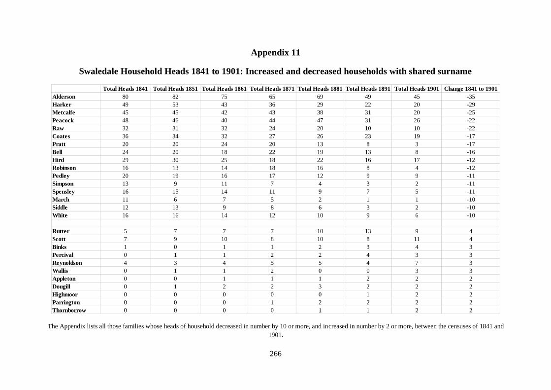
266
Appendix 11
Swaledale Household Heads 1841 to 1901: Increased and decreased households with shared surname
The Appendix lists all those families whose heads of household decreased in number by 10 or more, and increased in number by 2 or more, between the censuses of 1841 and
1901.
Total Heads 1841 Total Heads 1851 Total Heads 1861 Total Heads 1871 Total Heads 1881 Total Heads 1891 Total Heads 1901 Change 1841 to 1901
Alderson 80 82 75 65 69 49 45 -35
Harker 49 53 43 36 29 22 20 -29
Metcalfe 45 45 42 43 38 31 20 -25
Peacock 48 46 40 44 47 31 26 -22
Raw 32 31 32 24 20 10 10 -22
Coates 36 34 32 27 26 23 19 -17
Pratt 20 20 24 20 13 8 3 -17
Bell 24 20 18 22 19 13 8 -16
Hird 29 30 25 18 22 16 17 -12
Robinson 16 13 14 18 16 8 4 -12
Pedley 20 19 16 17 12 9 9 -11
Simpson 13 9 11 7 4 3 2 -11
Spensley 16 15 14 11 9 7 5 -11
March 11 6 7 5 2 1 1 -10
Siddle 12 13 9 8 6 3 2 -10
White 16 16 14 12 10 9 6 -10
Rutter 5 7 7 7 10 13 9 4
Scott 7 9 10 8 10 8 11 4
Binks 1 0 1 1 2 3 4 3
Percival 0 1 1 2 2 4 3 3
Reynoldson 4 3 4 5 5 4 7 3
Wallis 0 1 1 2 0 0 3 3
Appleton 0 0 1 1 1 2 2 2
Dougill 0 1 2 2 3 2 2 2
Highmoor 0 0 0 0 0 1 2 2
Parrington 0 0 0 1 2 2 2 2
Thornborrow 0 0 0 0 1 1 2 2

267
Appendix 12: Alderson Family Plot [1]
Appendices 12,13 and 14 show the forenames of all those Aldersons, Harkers and Metcalfes who were listed as
heads of household in the censuses of 1841 to 1901 in Upper Swaledale. The heads are enumerated in the left
column, and are listed across the rows as parent (1st generation), children (2nd generation), grandchildren (3rd
generation), date of birth (DoB), place of birth where known (PoB), and district of residence and occupation in
each census. The heads are colour coded as farmer &/or landowner (green), lead miner (blue), lead miner &
farmer (red), and others (blank). Shaded boxes indicate dates when the individual did not appear as a head of
household in the census.
1st Generation 2nd Gen 3rd Gen 4th Gen DoB PoB 1841 1841 1851 1851
1 Bartholemew 1763 Reeth Reeth Pauper formerly stonemason
2 Wife Nancy 1787 Healaugh
3 Margaret 1769 Muker Own means
4 Christiana 1771 Arkindale Reeth Reeth Pauper
5 Thomas 1771 Harkerside Reeth Butcher Reeth Retired butcher
6 John 1774 Muker Own means
7 Mary 1774 Grinton Reeth Farmer
8 Henry 1807 Grinton
9 John Henry 1845 Grinton
10 James 1846 Grinton
11 John 1775 Muker Muker Farmer Muker Landowner
12 William 1775 Harkers Birkdale Muker Farmer Muker Farmer
13 James 1778 Birkdale Muker Farmer Muker Farmer
14 Charles 1812 Crackpot Hall
15 Bessy 1776 Muker Own means
16 Edmund 1776 Melbecks Lead miner
17 Joseph 1776 Arkengarthdale Lead mine agent
18 John 1776 Angram Reeth Lead miner
19 John 1819 Grinton Reeth Lead miner
20 Wife Mary 1821 Reeth
21 Mary 1778 Arkendale Arkengarthdale Pauper
22 Christopher 1781 Birkdale Muker Farmer Muker Farmer
23 George 1817 Wmland Mallerstang
24 John 1780 Grinton Reeth Lead miner
25 James 1818 Grinton
26 John 1785 Wmland Brough Muker Lead miner Muker Labourer
27 James 1821 Birkdale Hilltop
28 Christopher 1860 Muker
29 Christopher 1822 Birkdale Hilltop
30 Christopher 1860 Muker
31 George 1781 Arkengarthdale Lead miner
32 Ann 1781 Reeth Labourer
33 Mary 1783 Arkengarthdale Reeth Retired Arkengarthdale Retired
34 Kitty 1784 Reeth Reeth Own means Reeth Annuitant
35 George 1821 Stonesdale
36 John Bland 1860 Wmland Winton
37 Charles 1869 Muker
38 Sarah 1785 Wmland Ravenstonedale
39 George 1786 Muker Farmer
40 Dinah 1790 Muker Muker Own means Muker Knitter
41 Thomas 1828 Melbecks
42 Wife Mary 1831 Melbecks
43 James 1855 Melbecks
44 Wife Ann 1858 Reeth
45 Thomas 1860 Melbecks
46 Isabella 1786 Muker Farmer
47 James 1792 Muker Muker Lead miner Muker Lead miner
48 Miles 1831 Hartlakes Muker
49 John 1786 Muker Farmer
50 Richard 1792 Satron Muker Lead miner Muker Farmer
51 Elizabeth 1786 Melbecks Own means
52 George 1786 Melbecks Lead miner
53 Wife Margaret 1787 Melbecks Melbecks Farmer
54 Rodger 1786 Arkengarthdale Farmer
55 John 1786 Arkengarthdale Lead miner
56 Thomas 1787 Reeth Farmer
57 George 1819 Healaugh Reeth Lead miner
58 Thomas 1789 Reeth Reeth Farmer
59 John 1794 Muker Muker Farmer Muker Farmer
60 Anthony 1799 Muker Muker Farmer Muker Landowner & Farmer
61 William 1791 Muker Lead miner
62 John 1791 Reeth Lead miner

268
Alderson Family Plot [2]
1st Generation 2nd Gen 3rd Gen 4th Gen DoB PoB 1841 1841 1851 1851
63 David 1791 Wmland Brough
64 Thomas 1841 Fremington
65 Esther 1831 Reeth
66 John 1802 Muker Melbecks Gamekeeper
67 William 1842 Muker
68 Thomas 1846 Muker
69 George 1803 Muker Muker Farmer Muker Landowner & Farmer
70 Thomas 1805 Keld Muker Innkeeper Muker Innkeeper, Farmer & Lead Miner
71 Wife Mary 1815 Westm Landford
72 William 1808 Angram Muker Lead miner Muker Lead miner
73 Wife Mary 1808 Westm Ravenstonedale
74 Richard 1794 Arkendale Arkengarthdale Farmer
75 Richard 1825 Arkengarthdale Reeth Farmer
76 George 1841 Arkengarthdale
77 Christopher 1875 Fremington
78 William 1794 Arkendale Arkengarthdale Lead miner Arkengarthdale Farmer
79 Wife Mary 1797 Hawes
80 Thomas 1829 Arkengarthdale
81 Wife Barbara 1843 Arkengarthdale
82 William 1831 Arkengarthdale
83 Jonathan 1838 Arkendale
84 Ann 1795 Riddings Reeth Farmer's widow
85 Edward 1829 Reeth
86 John 1796 Muker Farmer
87 Joseph 1796 Melbecks Lead miner
88 John 1826 Ivelet Melbecks Lead miner
89 Christopher 1830 Ivelet
90 Henry 1796 Arkengarthdale Labourer
91 Wife Margaret 1795 Arkendale Arkengarthdale Housekeeper
92 George 1796 Arkengarthdale Lead miner
93 James 1796 Arkengarthdale Farmer
94 Jonathan 1796 Arkengarthdale Joiner
95 Thomas 1824 Arkendale Arkengarthdale Carpenter
96 John R 1851 Arkengarthdale
97 Joseph 1861 Arkengarthdale
98 Jonathan 1796 Arkendale Arkengarthdale Lead mine agent Arkengarthdale Lead mine agent
99 Ann 1796 Reeth Lead miner's widow
100 Jonathan 1797 Arkendale Reeth Lead miner
101 George 1797 Arkendale Arkengarthdale Lead mine agent Arkengarthdale Lead mine agent
102 Wife Hannah 1784 Cumb Alston Muker Own means
103 Mary 1798 Arkendale Arkengarthdale Farmer
104 Edward 1798 Thwaite
105 Edward 1842 Hawes
106 Thomas 1799 Muker Labourer
107 Margaret 1799 Muker Reeth Lead miner's widow
108 Thomas 1824 Smarber
109 Charles 1809 Wmland Hellgill Muker Lead miner Muker Lead miner & Farmer
110 Wife Elizabeth 1818 Muker
111 Thomas 1800 Muker Lead miner
112 Edward 1810 Angram Muker Own means Muker Farmer
113 Margaret 1800 Grinton
114 David 1801 Wmland Eubank Reeth Carrier Reeth Farmer
115 Thomas 1801 Muker Lead miner
116 Wife Mary Ann 1811 Muker Muker Lead miner's widow
117 Miles 1836 Heugh Satron
118 Wife Margaret 1836 Rash
119 Henry 1859 Muker
120 Joseph 1866 Rash
121 William 1801 Arkengarthdale Lead miner
122 Richard 1801 Arkengarthdale Farmer
123 Isaac 1801 Arkengarthdale Arkengarthdale Lead miner Arkengarthdale Lead miner
124 William 1838 Arkengarthdale

269
Alderson Family Plot [3]
1st Generation 2nd Gen 3rd Gen 4th Gen DoB PoB 1841 1841 1851 1851
125 John 1801 Doncaster Reeth Farmer Reeth Farmer
126 John 1831 Bowes
127 Christopher 1842 Cringley
128 Joseph 1843 Cringley
129 Wife Ruth 1839 Bowes
130 John 1812 Wmland Hellgill Muker Labourer Muker Farmer
131 John 1843 Muker
132 Thomas 1872 Muker
133 George 1851 Muker
134 Joseph 1802 Arkendale Arkengarthdale Lead miner Arkengarthdale Lead miner
135 James 1834 Arkengarthdale
136 Sarah 1803 Booze Reeth Farmer
137 Simon 1813 Keld Muker Lead miner Muker Engine tenter & Farmer
138 Wife Elizabeth 1814 Wmland Mallerstang
139 Ralph 1840 Muker
140 James 1848 Muker
141 John 1813 Muker Muker Farmer Muker Farmer
142 Christopher 1841 Keld
143 John 1854 Muker
144 Elizabeth 1805 Muker Farmer
145 George 1805 Keld Reeth Gamekeeper Reeth Gamekeeper
146 William 1805 Richmond Reeth Tailor Reeth Tailor
147 Joseph 1806 Arkengarthdale Lead miner
148 Job 1806 Arkengarthdale Miller
149 Wife Elizabeth 1808 Arkendale Arkengarthdale Miller
150 Job 1845 Arkendale
151 John 1806 Reeth Workhouse master
152 Christopher 1806 Grinton Reeth Carrier
153 John 1841 Reeth
154 Wife Ann 1844 Reeth
155 John 1807 Grinton Reeth Lead miner
156 John 1815 Keld Muker Landowner & Farmer
157 John 1841 Angram
158 James 1873 Muker
159 John 1875 Muker
160 Christopher 1808 Arkengarthdale Arkengarthdale Lead miner Arkengarthdale Lead miner
161 Emmerson 1838 Arkendale
162 Elizabeth 1808 Arkengarthdale
163 John 1836 Arkengarthdale
164 John 1817 Melbecks Melbecks Lead miner
165 Edward 1810 Muker Coal miner
166 George 1819 Birkdale Muker Farmer
167 Wife Ann 1808 Keld
168 Richard 1848 Muker Greens
169 George 1843 Muker
170 James 1811 Muker Labourer
171 Simon 1811 Muker Farmer
172 Simon 1811 Arkengarthdale Lead miner
173 James 1811 Healaugh Reeth Butcher Reeth Butcher & Farmer
174 Nathan 1842 Healaugh
175 James 1849 Grinton
176 John 1836 Reeth
177 John 1811 Reeth Lead miner
178 John 1811 Reeth Labourer
179 James 1811 Melbecks Melbecks Lead miner
180 Isaiah 1845 Melbecks
181 George 1850 Melbecks
182 John 1852 Melbecks
183 James 1853 Melbecks
184 William 1857 Melbecks
185 Thomas 1811 Grinton Reeth Farmer & Labourer
186 Wife Mary 1819 Grinton

270
Alderson Family Plot [4]
1st Generation 2nd Gen 3rd Gen 4th Gen DoB PoB 1841 1841 1851 1851
187 William 1840 Grinton
188 Mary 1811 Arkengarthdale Arkengarthdale Lead miner
189 John 1811 Reeth Reeth Lead miner
190 Thomas 1820 Thorns Muker Coal miner & Farmer
191 Alice 1820 Birkdale Muker Farmer
192 Richard 1824 Muker Muker Lead miner & Farmer
193 William 1824 Wmland Stainmore Muker Coal miner
194 John 1815 Arkindale Reeth Lead miner Reeth Lead miner
195 Christopher 1815 Grinton
196 Henry 1843 Grinton
197 Jane 1816 Muker Grocer
198 John 1816 Muker Farmer
199 Christopher 1816 Arkengarthdale Lead miner
200 John 1816 Grinton Reeth Lead miner
201 Thomas 1825 Muker Muker Lead miner
202 Wife Ann 1823 Muker
203 William 1835 Wmland Brough
204 William 1870 Muker
205 Joseph 1875 Muker
206 Richard 1837 Wmland Brough or Muker
207 James 1817 Arkengarthdale Arkengarthdale Lead miner
208 John 1818 Gunnerside
209 George 1845
210 John 1819 Reeth Reeth Sawyer
211 George 1826 Keld Muker Landowner & Farmer
212 John 1853 Skeughead
213 Jonathan 1820 Arkengarthdale
214 John 1849 Arkengarthdale
215 Joseph 1821 Ivelet Melbecks Lead miner
216 Wife Alice 1824 Melbecks
217 James 1856 Melbecks
218 William 1861 Melbecks
219 Christopher 1821 Grinton
220 Wife Mary 1814 Reeth
221 Ralph 1822 Arkendale Arkengarthdale Lead miner
222 James 1823 Ivelet Arkengarthdale Lead miner Melbecks Lead miner
223 John 1823 Arkendale Reeth Lead miner
224 William 1824 Lodge Green Melbecks Cordwainer
225 George 1854 Melbecks
226 Elizabeth 1826 Muker Muker Farmer's wife
227 Michael 1825 Coniston Reeth Lead miner
228 Wife Margaret 1827 Reeth
229 Thomas 1827 Muker Muker Lead miner
230 George 1827 Muker Muker Lead miner
231 Alexander 1855 Kisdon
232 George 1828 Arkengarthdale
233 Jane 1828 Reeth
234 William 1829 Thwaite Muker Innkeeper & Farmer
235 James 1830 Thwaite
236 Elizabeth 1833 Arkengarthdale
237 Joseph 1836 Melbecks
238 George 1836 Durham Chapel Row
239 Emanuel 1824 Manchester
240 Ann 1821 Reeth
241 Henry 1817 Muker Close Hills
242 Wife Hannah 1817 Muker Close Hills
243 Robert 1825 Reeth
244 Rachel 1852 Muker
245 James 1850 Starforth Barningham
246 David 1810 Bowes
247 James 1849 Reeth
248 Richard 1841 Muker

271
Alderson Family Plot [5]
1861 1861 1871 1871 1881 1881 1891 1891 1901 1901
1
2 Reeth Pauper
3
4
5
6
7
8 Reeth Carrier & Farmer Reeth Carrier & Farmer
9 Reeth Farmer Reeth Retired farmer Reeth Carrier
10 Reeth Farmer Reeth Farmer Muker Farmer
11
12
13
14 Muker Landowner & Farmer Muker Landowner & Farmer
15
16
17
18 Reeth Retired lead miner
19
20 Reeth Lead miner's widow
21
22
23 Muker Farmer Muker Landowner & Farmer
24
25 Reeth Lead miner Reeth Lead mine agent
26
27 Muker Farmer Muker Farmer Muker Farmer Muker Farmer
28 Muker Farmer Muker Farmer
29 Muker Farmer Muker Landowner & Farmer Muker Farmer
30 Muker Farmer Muker Farmer
31
32
33
34
35 Muker Coal miner Muker Farmer
36 Muker Coal miner
37 Muker Farmer Muker Farmer
38 Muker Stockings knitter
39
40 Muker Knitter
41 Melbecks Lead miner Melbecks Lead miner Reeth Farmer Reeth Farmer
42 Reeth Farmer
43 Reeth Lead miner Reeth Stonemason
44 Reeth Lodging house keeper
45 Reeth Stonemason Reeth Stonemason
46
47
48 Muker Lead miner & Farmer
49
50 Muker Farmer
51
52
53
54
55
56
57 Reeth Lead miner Reeth Retired mine agent
58
59
60 Muker Farmer Muker Farmer
61
62
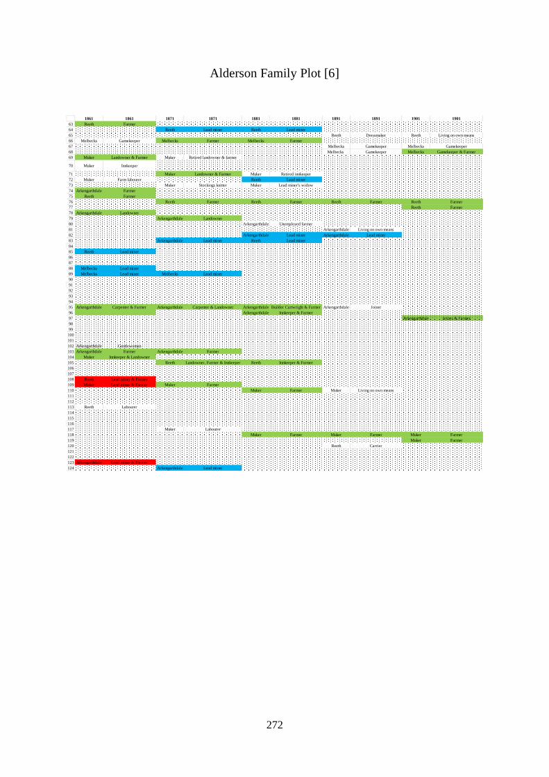
272
Alderson Family Plot [6]
1861 1861 1871 1871 1881 1881 1891 1891 1901 1901
63 Reeth Farmer
64 Reeth Lead miner Reeth Lead miner
65 Reeth Dressmaker Reeth Living on own means
66 Melbecks Gamekeeper Melbecks Farmer Melbecks Farmer
67 Melbecks Gamekeeper Melbecks Gamekeeper
68 Melbecks Gamekeeper Melbecks Gamekeeper & Farmer
69 Muker Landowner & Farmer Muker Retired landowner & farmer
70 Muker Innkeeper
71 Muker Landowner & Farmer Muker Retired innkeeper
72 Muker Farm labourer Reeth Lead miner
73 Muker Stockings knitter Muker Lead miner's widow
74 Arkengarthdale Farmer
75 Reeth Farmer
76 Reeth Farmer Reeth Farmer Reeth Farmer Reeth Farmer
77 Reeth Farmer
78 Arkengarthdale Landowner
79 Arkengarthdale Landowner
80 Arkengarthdale Unemployed farmer
81 Arkengarthdale Living on own means
82 Arkengarthdale Lead miner Arkengarthdale Lead miner
83 Arkengarthdale Lead miner Reeth Lead miner
84
85 Reeth Lead miner
86
87
88 Melbecks Lead miner
89 Melbecks Lead miner Melbecks Lead miner
90
91
92
93
94
95 Arkengarthdale Carpenter & Farmer Arkengarthdale Carpenter & Landowner Arkengarthdale Builder Cartwright & Farmer Arkengarthdale Joiner
96 Arkengarthdale Innkeeper & Farmer
97 Arkengarthdale Joiner & Farmer
98
99
100
101
102 Arkengarthdale Gentlewoman
103 Arkengarthdale Farmer Arkengarthdale Farmer
104 Muker Innkeeper & Landowner
105 Reeth Landowner, Farmer & Innkeeper Reeth Innkeeper & Farmer
106
107
108 Reeth Lead miner & Farmer
109 Muker Lead miner & Farmer Muker Farmer
110 Muker Farmer Muker Living on own means
111
112
113 Reeth Labourer
114
115
116
117 Muker Labourer
118 Muker Farmer Muker Farmer Muker Farmer
119 Muker Farmer
120 Reeth Carrier
121
122
123 Arkengarthdale Lead miner & Farmer
124 Arkengarthdale Lead miner

273
Alderson Family Plot [7]
1861 1861 1871 1871 1881 1881 1891 1891 1901 1901
125 Reeth Farmer
126 Arkengarthdale Farmer Arkengarthdale Farmer Arkengarthdale Farmer
127 Reeth Farmer
128 Reeth Draper & Farmer Arkengarthdale Lead ore washer
129 Reeth Living on own means
130 Muker Farmer Muker Farmer
131 Muker Farmer Muker Farmer Muker Farmer
132 Muker Farmer
133 Muker Farmer Muker Farmer
134 Reeth Lead miner
135 Arkengarthdale Lead miner Arkengarthdale Lead miner
136
137 Muker Stonemason Muker Landowner & Farmer Muker Farmer
138 Muker Farmer
139 Muker Innkeeper & Farmer Muker Innkeeper & Farmer Muker Innkeeper & Farmer
140 Muker Farmer Muker Farmer
141 Muker Farmer Muker Landowner & Farmer Muker Farmer
142 Muker Farmer Muker Farmer Muker Farmer
143 Muker Farmer Muker Farmer
144
145 Reeth Gamekeeper & Farmer
146 Reeth Tailor Reeth Tailor Reeth Tailor
147
148
149
150 Arkengarthdale Corn dealer & Farmer
151
152
153 Reeth Lead miner Reeth Lead miner
154 Arkengarthdale Dressmaker Arkengarthdale Dressmaker
155 Reeth Lead miner
156 Muker Landowner & Farmer Muker Farmer Muker Farmer Muker Farmer
157 Muker Farmer Muker Farmer Muker Farmer Muker Farmer
158 Muker Farmer
159 Muker Farmer
160 Reeth Lead miner Arkengarthdale Lead miner Reeth Lead miner
161 Reeth Lead mine agent Reeth Workhouse master
162 ArkengarthdaleFlour dealer, Carrier &
FarmerArkengarthdale Innkeeper
163 Arkengarthdale Flour dealer & Farmer Arkengarthdale Merchant & Farmer Muker Grocer & Tea dealer
164
165
166 Muker Farmer
167 Muker Farmer Muker Landowner & Farmer Muker Postmistress & Farmer
168 Muker Farmer
169 Muker Retired police officer
170
171
172
173 Reeth Butcher & Farmer Reeth Farmer
174 Reeth Farmer
175 Reeth Wood carrier Reeth Farm labourer Reeth Shepherd Reeth Shepherd
176 Reeth Lead miner & Farmer Reeth Farmer Reeth Farmer
177
178
179 Melbecks Lead miner Melbecks Farmer
180 Melbecks Lead miner
181 Melbecks Lead miner Melbecks Lead miner Melbecks Farmer
182 Melbecks Lead miner
183 Melbecks Farmer
184 Melbecks Farmer Melbecks Farmer
185 Reeth Lead miner Reeth Farmer Reeth Farmer
186 Reeth Farmer

274
Alderson Family Plot [8]
1861 1861 1871 1871 1881 1881 1891 1891 1901 1901
187 Reeth Farmer
188 Arkengarthdale Lead miner
189 Reeth Lead miner
190
191
192
193
194
195 Reeth Farmer
196 Reeth Lead miner Reeth Coal miner
197
198
199
200 Reeth Lead miner Reeth Lead miner
201 Muker Lead miner Muker Lead miner & Farmer
202 Muker Farmer Muker Stockings knitter
203 Muker Farmer Muker Farmer Muker Farmer
204 Muker Farmer
205 Muker Farmer
206 Muker Coal miner Muker Grocer & Clogger Muker Grocer
207 Arkengarthdale Lead miner
208 Reeth Farmer
209 Reeth Lead miner & Farmer Reeth Farmer Reeth Cattle dealer & Farmer
210
211 Muker Farmer Muker Landowner & Farmer Muker Farmer Muker Farmer
212 Muker Farm labourer Muker Farmer Muker Farmer
213 Reeth Shoemaker Reeth Cordwainer Reeth Shoemaker Reeth Shoemaker
214 Reeth Living on own means
215 Melbecks Lead miner Melbecks Lead miner & Farmer
216 Melbecks Farmer Melbecks Grocer, Carrier & Farmer
217 Melbecks Carrier & Farmer
218 Melbecks Lead miner Melbecks Lead miner & Farmer
219 Reeth Labourer
220 Reeth Pauper (annuitant)
221
222 Reeth Lead miner Reeth Lead miner & Farmer
223 Reeth Lead miner
224 Melbecks Cordwainer Melbecks Cordwainer & Farmer Melbecks Shoemaker & Farmer Melbecks Retired shoemaker & Farmer Melbecks Living on own means
225 Melbecks Shoemaker & Clogger Melbecks Lead miner Melbecks Shoemaker & Bootmaker
226
227 Reeth Lead miner
228 Melbecks Farmer Melbecks Living on own means
229 Muker Lead miner
230 Muker Lead miner Muker Lead miner Muker Farmer
231 Arkengarthdale Shepherd & Farm labourer Melbecks Farmer Melbecks Farmer
232 Arkengarthdale Lead miner
233 Reeth Farmer Reeth Farmer Reeth Farmer Reeth Living on own means
234
235 Muker Innkeeper
236 Arkengarthdale Retired nurse Arkengarthdale Shoemaker
237 Melbecks Carpenter
238 Arkengarthdale Lead miner Arkengarthdale Lead miner
239 Melbecks Innkeeper & Saddler Melbecks Saddler & Innkeeper
240 Reeth Retired housekeeper Melbecks Living on own means
241 Muker Shepherd
242 Muker Stockings knitter
243 Muker Retired farmer
244 Melbecks Annuitant
245 Arkengarthdale Lead miner
246 Arkengarthdale Farmer
247 Reeth Farmer's hand
248 Muker Living on own means Muker Shopkeeper & General dealer
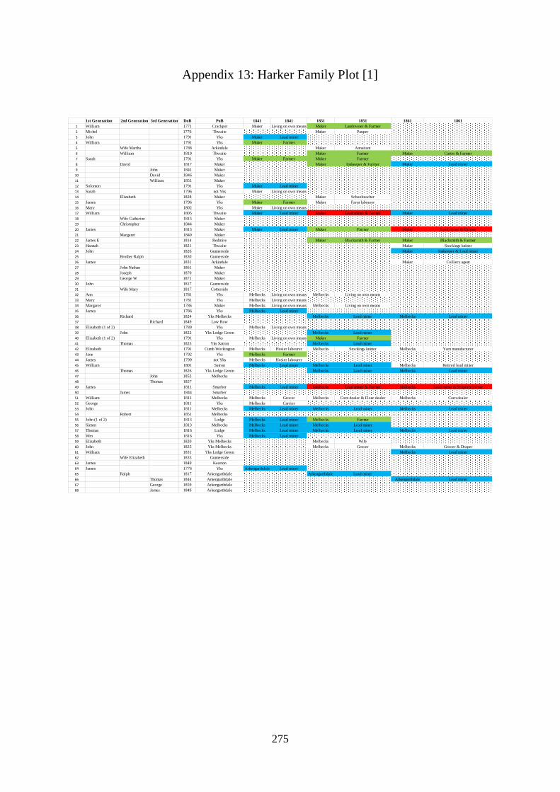
275
Appendix 13: Harker Family Plot [1]
1st Generation 2nd Generation 3rd Generation DoB PoB 1841 1841 1851 1851 1861 1861
1 William 1771 Crackpot Muker Living on own means Muker Landowner & Farmer
2 Michel 1776 Thwaite Muker Pauper
3 John 1791 Yks Muker Lead miner
4 William 1791 Yks Muker Farmer
5 Wife Martha 1788 Arkindale Muker Annuitant
6 William 1819 Thwaite Muker Farmer Muker Carter & Farmer
7 Sarah 1791 Yks Muker Farmer Muker Farmer
8 David 1817 Muker Muker Innkeeper & Farmer Muker Lead miner
9 John 1841 Muker
10 David 1846 Muker
11 William 1851 Muker
12 Solomon 1791 Yks Muker Lead miner
13 Sarah 1796 not Yks Muker Living on own means
14 Elizabeth 1828 Muker Muker Schoolteacher
15 James 1796 Yks Muker Farmer Muker Farm labourer
16 Mary 1802 Yks Muker Living on own means
17 William 1805 Thwaite Muker Lead miner Muker Lead miner & Farmer Muker Lead miner
18 Wife Catharine 1815 Muker
19 Christopher 1844 Muker
20 James 1813 Muker Muker Lead miner Muker Farmer Muker Lead miner & Farmer
21 Margaret 1840 Muker
22 James E 1814 Redmire Muker Blacksmith & Farmer Muker Blacksmith & Farmer
23 Hannah 1821 Thwaite Muker Stockings knitter
24 John 1826 Gunnerside Muker Innkeeper & Lead miner
25 Brother Ralph 1830 Gunnerside
26 James 1831 Arkindale Muker Colliery agent
27 John Nathan 1861 Muker
28 Joseph 1870 Muker
29 George W 1871 Muker
30 John 1817 Gunnerside
31 Wife Mary 1817 Cotterside
32 Ann 1781 Yks Melbecks Living on own means Melbecks Living on own means
33 Mary 1781 Yks Melbecks Living on own means
34 Margaret 1786 Muker Melbecks Living on own means Melbecks Living on own means
35 James 1786 Yks Melbecks Lead miner
36 Richard 1824 Yks Melbecks Melbecks Lead miner Melbecks Lead miner
37 Richard 1849 Low Row
38 Elizabeth (1 of 2) 1789 Yks Melbecks Living on own means
39 John 1822 Yks Lodge Green Melbecks Lead miner
40 Elizabeth (1 of 2) 1791 Yks Melbecks Living on own means Muker Farmer
41 Thomas 1825 Yks Satron Melbecks Lead miner
42 Elizabeth 1791 Cumb Workington Melbecks Hosier labourer Melbecks Stockings knitter Melbecks Yarn manufacturer
43 Jane 1792 Yks Melbecks Farmer
44 James 1799 not Yks Melbecks Hosier labourer
45 William 1801 Satron Melbecks Lead miner Melbecks Lead miner Melbecks Retired lead miner
46 Thomas 1826 Yks Lodge Green Melbecks Lead miner Melbecks Lead miner
47 John 1852 Melbecks
48 Thomas 1857
49 James 1811 Smarber Melbecks Lead miner Melbecks Lead miner & Farmer Melbecks Lead miner & Property owner
50 James 1844 Smarber
51 William 1811 Melbecks Melbecks Grocer Melbecks Corn dealer & Flour dealer Melbecks Corn dealer
52 George 1811 Yks Melbecks Carrier
53 John 1811 Melbecks Melbecks Lead miner Melbecks Lead miner Melbecks Lead miner
54 Robert 1851 Melbecks
55 John (1 of 2) 1813 Lodge Melbecks Lead miner Melbecks Farmer
56 Simon 1813 Melbecks Melbecks Lead miner Melbecks Lead miner
57 Thomas 1816 Lodge Melbecks Lead miner Melbecks Lead miner Melbecks Lead miner
58 Wm 1816 Yks Melbecks Lead miner
59 Elizabeth 1820 Yks Melbecks Melbecks Wife
60 John 1825 Yks Melbecks Melbecks Grocer Melbecks Grocer & Draper
61 William 1831 Yks Lodge Green Melbecks Lead miner
62 Wife Elizabeth 1833 Gunnerside
63 James 1849 Kearton
64 James 1776 Yks Arkengarthdale Lead miner
65 Ralph 1817 Arkengarthdale Arkengarthdale Lead miner
66 Thomas 1844 Arkengarthdale Arkengarthdale Lead miner
67 George 1859 Arkengarthdale
68 James 1849 Arkengarthdale

276
Harker Family Plot [2]
Page 2
1st Generation 2nd Generation 3rd Generation DoB PoB 1841 1841 1851 1851 1861 1861
69 Ann 1781 Yks Arkengarthdale Farmer
70 Dinah 1811 Arkendale Arkengarthdale Lead ore washer Arkengarthdale Retired lead ore washer
71 Hannah 1786 Yks Arkengarthdale Farmer
72 John 1811 Arkendale Arkengarthdale Lead miner
73 Joseph 1791 Yks Arkengarthdale Lead miner
74 Wife Ann 1791 Arkendale Arkengarthdale Lead miner's widow Arkengarthdale Lead miner's widow
75 Ambrose 1820 Arkengarthdale Arkengarthdale Lead miner
76 Joseph 1822 Arkengarthdale
77 Joseph 1856 Arkengarthdale
78 James 1791 Arkendale Arkengarthdale Butcher Arkengarthdale Butcher & Landowner Arkengarthdale Farmer
79 Ralph 1791 Yks Arkengarthdale Farmer
80 Mary 1791 Arkendale Arkengarthdale Living on own means Arkengarthdale Charwoman Arkengarthdale Lead miner's widow
81 Margaret 1791 Yks Arkengarthdale Living on own means
82 James 1830 Arkengarthdale Arkengarthdale Lead miner Arkengarthdale Lead miner
83 George 1855 Arkengarthdale
84 Jane 1796 Swaledale Arkengarthdale Living on own means Arkengarthdale Lead miner's widow
85 John 1796 Arkendale Arkengarthdale Lead miner
86 George 1806 Arkendale Arkengarthdale Lead miner Arkengarthdale Lead miner
87 Wife Ann 1807 Arkendale Arkengarthdale Lead miner's widow Arkengarthdale Farmer
88 John 1833 Arkengarthdale
89 Mary 1842 Swaledale
90 James 1806 Muker Arkengarthdale Lead miner Arkengarthdale Lead miner & Farmer Arkengarthdale Lead ore smelter
91 Ralph 1810 Yks Arkengarthdale Butcher & Clogger & Farmer
92 Timothy 1841 Durham Barnard Castle
93 Joseph 1811 Yks Arkengarthdale Farmer
94 Adam 1811 Thwaite Arkengarthdale Lead miner Arkengarthdale Lead miner Arkengarthdale Lead miner
95 Ralph 1816 Yks Arkengarthdale Lead ore smelter Arkengarthdale Lead miner Arkengarthdale Lead ore smelter
96 Wife Ann 1814 Arkengarthdale
97 George 1847 Arkengarthdale
98 Thomas 1849 Arkengarthdale
99 Ralph 1857 Arkengarthdale
100 George 1817 Arkendale Arkengarthdale Lead miner Arkengarthdale Lead miner Arkengarthdale Lead miner & Wesleyan local preacher
101 Wife Margaret 1821
102 Joseph 1818 Arkendale Arkengarthdale Lead miner Arkengarthdale Lead miner
103 Ralph 1821 Yks Arkengarthdale Lead miner
104 James 1821 Yks Arkengarthdale Lead miner & Farmer
105 Robert 1822 Yks Arkengarthdale Lead miner
106 John 1825 Yks Arkengarthdale Lead miner
107 George 1831 Durham West Pits Arkengarthdale Lead miner & Farmer
108 Deborah 1839 Arkengarthdale
109 James 1844 Arkengarthdale
110 Wife Isabella 1844 Arkengarthdale
111 James 1785 Yks Reeth Miner Reeth Farmer Reeth Farmer
112 John 1825 Grinton Reeth Farmer
113 Jas 1852 Marrick
114 James 1801 Yks Reeth Farmer
115 James 1803 Yks Whitaside Reeth Farmer Reeth Farmer Reeth Farmer
116 Wife Ann 1800 Grinton
117 Leonard 1811 Yks Reeth Living on own means
118 William 1816 Yks Reeth Preciptor
119 Ralph 1784 Yks Arkengarthdale Reeth Retired farmer
120 Esther 1785 Yks Melbeck Reeth Annuitant
121 Elizabeth 1788 Reeth Reeth Pauper
122 Nanney 1802 Yks Muker Reeth Farmer Reeth Landowner & Farmer
123 Simon 1834 Whiteside
124 John 1808 Smarber Reeth Farmer
125 Simon 1853 Grinton
126 Ambrose 1820 Yks Sturfit Hall Reeth Lead miner
127 Wife Margaret 1824 Arkindale Reeth Farmer
128 Joseph 1822 Yks Arkindale Reeth Lead miner
129 Joseph 1822 Yks Arkendale Reeth Farmer Arkengarthdale Farmer
130 John 1855 Arkengarthdale
131 Ambrose 1858 Arkengarthdale
132 James 1859 Reeth

277
Harker Family Plot [3]
1871 1871 1881 1881 1891 1891 1901 1901
1
2
3
4
5
6 Muker Carrier & Farmer
7
8 Muker Farmer Muker Farmer Muker Retired farmer
9 Muker Lead miner & Farmer Muker Farmer Muker Shepherd
10 Muker Lead miner Muker Living on own means
11 Muker Farmer
12
13
14
15
16
17
18 Muker Farmer Muker Farmer Muker Farmer
19 Muker Farmer
20
21 Muker Pauper
22 Muker Blacksmith, Landowner & Farmer Muker Blacksmith & Farmer
23
24
25 Muker Innkeeper Muker Innkeeper & Farmer Muker Innkeeper & Farmer
26 Muker Colliery agent & Farmer Muker Colliery agent & Farmer Muker Colliery agent & Farmer
27 Muker Farmer Muker Farmer
28 Muker Coal miner & Farmer
29 Muker Colliery manager
30 Muker Farmer Muker Farmer
31 Muker Living on own means
32
33
34
35
36 Melbecks Lead miner Melbecks Lead miner
37 Melbecks Lead miner
38
39
40
41
42
43
44
45
46 Melbecks Lead miner & Farmer Melbecks Lead miner & Farmer Muker Farmer
47 Melbecks Lead miner & Shepherd Melbecks Shepherd & Farmer Melbecks Shepherd & Farmer
48 Muker Farmer
49 Melbecks Retired miner Melbecks Farmer
50 Melbecks Lead miner
51
52
53 Melbecks Lead miner & Farmer Melbecks Farmer
54 Muker Farmer
55
56
57
58
59
60 Melbecks Grocer & Draper Melbecks Retired grocer Melbecks Retired grocer
61 Melbecks Lead miner & Farmer Melbecks Lead miner & Farmer
62 Muker Housekeeper Muker Farmer
63 Melbecks Lead miner
64
65
66
67 Arkengarthdale Lead miner
68 Arkengarthdale Lead ore smelter & Wesleyan local preacher
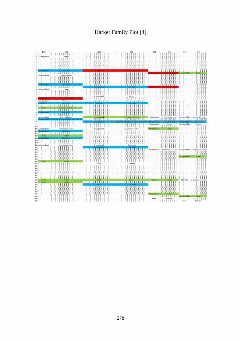
278
Harker Family Plot [4]
1871 1871 1881 1881 1891 1891 1901 1901
69
70 Arkengarthdale Pauper
71
72
73
74
75
76 Arkengarthdale Lead miner Arkengarthdale Lead ore smelter & Farmer
77 Arkengarthdale Lead miner & Farmer Arkengarthdale Farmer
78 Arkengarthdale Retired butcher
79
80
81
82 Arkengarthdale Lead miner
83 Arkengarthdale Lead miner Arkengarthdale Lead miner & Farmer
84 Arkengarthdale Pauper
85
86
87 Arkengarthdale Pauper
88 Arkengarthdale Lead miner & Farmer
89 Arkengarthdale Annuitant
90 Melbecks Lead miner Melbecks Lead miner
91
92 Reeth Carpenter & Farmer
93
94 Arkengarthdale Lead miner
95
96 Arkengarthdale Grocer & Draper Arkengarthdale Shopkeeper & Farmer Arkengarthdale Living on own means Arkengarthdale Living on own means
97 Arkengarthdale Lead ore smelter & Wesleyan local preacher
98 Arkengarthdale Lead mine agent & Wesleyan local preacher Arkengarthdale Lead mine agent Arkengarthdale Mine agent
99 Arkengarthdale Grocer Arkengarthdale Grocer
100
101 Arkengarthdale Lead miner's widow Arkengarthdale Lead miner's widow Arkengarthdale Farmer
102 Arkengarthdale Lead miner
103
104 Reeth Farmer
105 Arkengarthdale Lead miner
106
107
108 Arkengarthdale Lead miner's widow Arkengarthdale Charwoman
109 Arkengarthdale Lead miner
110 Arkengarthdale Lead miner's widow Arkengarthdale Living on own means
111
112
113 Arkengarthdale Farmer
114
115 Reeth Farmer
116 Reeth Annuitant
117
118
119
120
121
122
123 Reeth Farmer Reeth Farmer Melbecks Farmer Melbecks Living on own means
124 Reeth Farmer
125 Reeth Lead miner
126
127
128
129 Arkengarthdale Farmer
130 Arkengarthdale Farmer
131 Reeth Labourer
132 Reeth Labourer

279
Appendix 14: Metcalfe Family Plot [1]
1st Generation 2nd Generation 3rd Generation DoB PoB 1841 1841 1851 1851 1861 1861
1 Martha 1769 Keld Muker Muker Pauper
2 John 1776 Muker Farmer
3 John 1776 Muker Farmer
4 L.W 1778 Muker Living on own means
5 Margaret 1804 Muker Muker Farmer
6 Thomas 1833 Muker Muker Coal miner
7 John 1778 Muker Lead miner
8 Wife Ann 1791 Hardraw Muker Knitter Muker Widow
9 John 1812 Grinton Reeth Cattle dealer
10 Christopher 1831 Muker
11 John 1845 Springend
12 Wife Helen 1842 Muker
13 Joseph 1848 Grinton
14 Henry 1817 Muker Muker Lead miner Muker Lead miner & Farmer
15 Wife Elizabeth 1822 Muker
16 William 1823 Muker Muker Lead miner Muker Engine tenter lead mine
17 Thomas 1781 Aysgarth Muker Lead miner Muker Farmer
18 Mary Ann 1816 Cotterside Muker Farmer
19 Mawson 1832 Hellgill Muker Lead miner
20 John 1781 Muker Farmer
21 Thomas 1804 Muker Muker Lead miner & Farmer Muker Lead miner
22 Jane 1782 Muker Living on own means
23 George 1825 Muker Muker Lead miner
24 James 1827 Muker Muker Lead miner Muker Lead miner
25 Ann 1786 Muker Muker Living on own means Muker Farmer
26 John 1840 Calverts
27 George 1819 Ivelet Muker Lead miner & Farmer
28 James 1786 Muker Muker Farmer Muker Farmer
29 Thomas 1786 Muker Farmer
30 Thomas 1815 Muker Muker Farmer Muker Farmer
31 Mary 1796 Yorkshire Muker Living on own means Muker Farmer
32 Henry 1827 Angram Muker Lead miner Muker Coal miner & Farmer
33 Henry 1845 Muker
34 William 1847
35 Robert 1796 Hawes Muker Cordwainer Muker Shoemaker
36 John 1796 Muker Muker Farmer Muker Farmer
37 Lister 1824 Yorkshire Melbecks Lead miner
38 John 1828 Muker Muker Coal miner
39 Mary Ann 1833 Melbecks
40 Edward 1842 Muker
41 Richard 1801 West Stonesdale Muker Coal miner Muker Coal miner & Farmer Muker Farmer
42 Leonard 1828 Muker
43 John 1830 Angram Muker Lead miner
44 Richard 1860 Muker
45 Thomas 1870 Muker
46 Jane 1833 Muker
47 William 1834 Keld Muker Coal miner
48 Thomas 1842 Muker
49 Richard 1850 Muker
50 Jemima 1855 Muker
51 Michael 1801 Keld Muker Lead miner Muker Lead miner
52 John 1801 Muker Lead miner
53 Margaret 1803 Muker Muker Living on own means Muker Annuitant
54 Thomas 1827 Hardraw Muker Lead miner Muker Lead miner
55 Wife Jane 1832 Muker
56 Thomas 1851 Muker
57 James 1859 Muker
58 Christopher 1864 Wmland Kirby
59 John 1868 Muker
60 William 1807 Yorkshire Muker Farmer
61 William 1808 Grinton Muker Stonemason Muker Stonemason & Farmer Muker Stonemason
62 Thomas 1811 Muker Lead miner
63 Ralph 1818 Aysgarth Melbecks Lead miner
64 Anthony 1821 Hawes Muker Farm labourer
65 Christopher 1785 Melbecks Lead miner
66 Wife Mary 1783 Feetham Melbecks Farmer
67 Thomas 1822 Lodge Green Muker Lead miner
68 Leonard 1828 Melbecks Melbecks Lead miner
69 Robert 1788 Melbecks Lead miner
70 James 1791 Lodge Melbecks Lead miner Melbecks Annuitant

280
Metcalfe Family Plot [2]
1st Generation 2nd Generation 3rd Generation DoB PoB 1841 1841 1851 1851 1861 1861
71 Jane 1791 Melbecks Melbecks Melbecks NS
72 Robert 1824 Satron
73 Wife Margaret 1820 Whins
74 Thomas 1870 Muker
75 John 1791 Melbecks Lead miner
76 Wife Elizabeth 1797 Melbecks Melbecks Farmer Muker Pauper
77 Robert 1822 Grinton Melbecks Lead miner & Farmer
78 Wife Jane 1827 Grinton
79 John 1824 Melbecks Melbecks Lead miner Melbecks Lead miner
80 Wife Margaret 1823 Melbecks
81 Adam 1806 Melbecks Farmer
82 Ralph 1807 Cotterdale Melbecks Lead miner
83 John 1807 Whitaside Melbecks Lead miner Melbecks Lead miner
84 James 1811 Melbecks Lead miner
85 John 1811 Melbecks Lead miner
86 Merrel 1816 Melbecks Knitter
87 Thomas 1816 Melbecks Melbecks Lead miner Melbecks Lead miner
88 George 1827 Melbecks Melbecks Lead miner
89 George 1823 Melbecks Melbecks Lead miner
90 Wife Jane 1824 Melbecks
91 John 1846 Melbecks
92 William 1848 Melbecks
93 Jane 1771 Stainton Arkengarthdale Living on own means Arkengarthdale Pauper
94 Jane 1806 Yorkshire Arkengarthdale Housekeeper
95 Michael 1837 Yorkshire
96 Mary 1771 Arkengarthdale Living on own means
97 William 1806 Arkendale Arkengarthdale Lead miner Arkengarthdale Lead ore smelter
98 Henry 1836 Swaledale
99 Thomas 1769 Busk Reeth Pauper
100 Marmaduke 1813 Whitaside Reeth Game watcher & Shepherd
101 Mary 1840 Grinton
102 Elizabeth 1773 Reeth Living on own means
103 William 1776 Grinton Reeth Living on own means Reeth Landowner
104 George 1781 Reeth Farmer
105 Wife Isabella 1787 Gayle Reeth Living on own means
106 William 1786 Reeth Lead miner
107 Margaret 1791 Reeth Living on own means
108 William 1796 Reeth Saddler
109 Robert 1801 Fremington Reeth Miller Reeth Miller
110 Thomas 1801 Reeth Lead miner
111 Wife Margaret 1807 Muker Reeth Farmer
112 Thomas 1830 Sumer Reeth Farmer
113 James 1806 Crackpot Reeth Lead miner Reeth Lead miner
114 Wife Margaret 1806 Richmond Reeth Farmer
115 Thomas 1828 Healaugh Reeth Lead miner
116 Thomas 1840 Healaugh
117 William 1829 Healaugh Reeth Lead miner
118 Wife Mary Ann 1831 Whaugh
119 John 1835 Healaugh Reeth Lead miner
120 Wife Dinah 1841 Marrick
121 James 1860 Reeth
122 George 1806 Reeth Shoemaker
123 Thomas 1811 Crackpot Reeth Lead miner Reeth Lead miner
124 Wife Isabella 1813 Reeth
125 William 1813 Yorkshire
126 William 1815 Healaugh Reeth Lead miner Reeth Lead miner
127 Wife Mary 1816 Melbecks
128 Richard 1815 Hawes Reeth Hosier Melbecks Innkeeper & Labourer
129 Anthony 1816 Whitaside Reeth Farmer Reeth Farmer Reeth Farmer
130 John 1816 Yks Reeth Farmer Reeth Farmer
131 George 1817 Muker Reeth Farmer Reeth Farmer
132 George 1850 Grinton
133 John 1852 Grinton
134 Edward 1855 Grinton
135 Thomas 1855 Grinton
136 George 1820 Healaugh Reeth Lead miner Reeth Grocer
137 William 1822 Hurst
138 Elizabeth 1826 Whiteside
139 John 1838 Durham
140 Thomas NK Healaugh

281
Metcalfe Family Plot [3]
1871 1871 1881 1881 1891 1891 1901 1901
1
2
3
4
5 Muker Housekeeper
6 Muker Coal miner Muker Coal miner Muker Slate quarry labourer Muker Road labourer
7
8 Muker Widow Muker Housekeeper
9 Reeth Farmer Reeth Farmer Reeth Farmer
10 Muker Living on own means Muker Living on own means
11 Reeth Cattle dealer & Farmer Reeth Cattle dealer & Farmer Reeth Cattle dealer & Farmer
12 Reeth Domestic servant
13 Reeth Farmer & Wesleyan local Reeth Farmer & Wesleyan local
14
15 Muker Farmer Muker Farmer
16
17
18
19
20
21 Muker Yeoman
22
23
24
25
26 Muker Farmer Reeth Farmer
27
28
29
30 Muker Labourer & Farmer
31 Muker Annuitant
32
33 Muker Lead miner Muker Farmer
34 Muker Farmer
35
36
37
38
39 Melbecks Living on own means Melbecks Living on own means
40 Muker Coal miner Muker Coal miner
41 Muker Farmer Muker Farmer
42 Muker Labourer Muker Coal miner Muker Coal miner
43 Muker Coal miner Muker Coal miner Muker Stonemason
44 Muker Farmer Muker Farmer
45 Muker Coal miner
46 Muker Farmer
47 Muker Pitman & Farmer Muker Coal miner, Grocer & Farmer Muker Grocer & Farmer Muker Grocer & Farmer
48 Muker Labourer Muker Stonemason & Farmer Muker Stonemason Muker Stonemason
49 Muker Farmer
50 Muker Farmer
51
52
53
54 Muker Labourer Muker Labourer & Farmer
55 Muker Housekeeper
56 Muker Labourer Muker Farmer Muker Grocer & Carrier & Farmer
57 Muker Farmer
58 Muker Slate quarry labourer
59 Muker Labourer Muker Labourer
60
61 Muker Landowner & Farmer Muker Retired Stonemason
62
63
64 Muker Labourer Muker Farmer
65
66
67
68 Melbecks Lead miner & Farmer Melbecks Farmer Melbecks Farmer Melbecks Farmer
69
70

282
Metcalfe Family Plot [4]
1871 1871 1881 1881 1891 1891 1901 1901
71
72 Muker Lead miner
73 Melbecks Widow Melbecks Living on own means
74 Muker Farmer
75
76
77 Melbecks Lead miner
78 Melbecks Farmer
79 Melbecks Farmer
80 Melbecks Annuitant
81
82
83 Melbecks Lead miner & Farmer
84
85
86
87
88
89
90 Melbecks Landowner
91 Melbecks Lead miner
92 Melbecks Lead miner Melbecks Lead miner Melbecks Lead miner
93
94 Arkengarthdale Retired
95 Arkengarthdale Lead miner
96
97
98 Arkengarthdale Coal miner
99
100 Reeth Game watcher Reeth Game watcher
101 Reeth Shepherd Reeth Farm labourer
102
103
104
105
106
107
108
109
110
111
112 Reeth Farmer Reeth Farmer
113
114
115
116 Reeth Farmer Reeth Farmer
117
118 Reeth Widow
119 Reeth Farmer Reeth Farmer
120 Reeth Farmer Reeth Farmer
121 Reeth Joiner
122
123 Reeth Lead miner & Farmer
124 Reeth Farmer Reeth Living on own means
125 Reeth Shoemaker
126 Reeth Lead miner Reeth Lead miner
127 Reeth Living on own means
128 Reeth Farmer Reeth Farmer
129 Reeth Farmer
130
131 Reeth Farmer Reeth Farmer Melbecks Retired
132 Melbecks Lead miner Reeth Farmer Reeth Farmer
133 Melbecks Lead miner & Drainer
134 Melbecks Lead miner
135 Melbecks Lead miner
136 Reeth Butcher & Farmer Reeth Butcher & Grocer Reeth Grocer & Farrier
137 Reeth Lead miner Reeth Engine tenter Reeth Living on own means
138 Reeth Dairy maid Reeth Farmer
139 Reeth Farmer
140 Reeth Farmer

283
Appendix 15
Occupations of Household Heads of Five Kinship Families in Swaledale
Districts
Muker

284
Occupations of Household Heads of Five Kinship Families in Swaledale
Districts
Melbecks

285
Occupations of Household Heads of Five Kinship Families in Swaledale
Districts
Arkengarthdale

286
Occupations of Household Heads of Five Kinship Families in Swaledale
Districts
Reeth

287
Appendix 16
Household Heads and Persistent Surnames of Holgate Road [1]
1 Fothergill Labourer Bean Gardener Appleby Nurseryman Prince Newsvendor
2 Scott - 1 M.S. Thompson - 13 Annuitant Cockerill Cab driver Richardson -19
3 Schofield Cordwainer Barker - 11 Proprietor of Houses Milner - 29 Landed proprietor Hields
4
5 Jackson - 2 M.S. Bell Straw bonnett maker Forest Bailiff County Court Montgomery - 10 Painter
6
7 Mawson - 3 Laundress Montgomery - 10 Seamstress Waddington - 30 Coachman
8 Mawson - 3 Independent Scott - 1 Butcher Blanshard Retired farmer Humpherson Tinner & Brazier
9 Beck Carter Lomas - 8 Annuitant Halley - 31 Landed proprietor Nicholls Joiner
10 Gawthorp Independent Toes - 7 Shoemaker Spink Commission agent Sigsworth Painter
11 Nicholson - 4 Farmer Douglas Comb maker journeyman Harris - 32 Baker Sanderson Railway goods guard
12 Cooper Bankers Clerk Atkinson - 12 Waiter at an Inn Dennison Butcher Tinkler - 37 Provision dealer
13 Evans Collector of Excise Green Comb maker journeyman Conn - 33 Blacksmith Reid Shoemaker
14 Wilkinson Professor of music Rhodes - 15 Saddler Harrison - 18 Shaw Messenger living in
15 Todd - 5 Independent Sharpe Annuitant Harrison - 18 Bricklayer Nalton
16 Parkinson - 6 Solicitor Nalton Fundholder Somerset - 34 Cordwainer Woollous Retired butcher
17 Cawood Independent Wheatley - 16 Lodging house keeper Gray - 23 Provision dealer Broomhead Dressmaker
18 Park Cowkeeper Whitehead - 17 Engine fitter Lion - 35 Laundress Duff - 45 Gardener
19 Toes - 7 Cordwainer Butler Fund holder Coates Joy Pianoforte tuner
20 Lomas - 8 Widow Burnett Landed proprietor Seymour Gardener Cowan Assistant overseer
21 Powell - 9 Wheelwright Mawson - 3 Stone mason Nicholson - 4 Former cow keeper Creser - 46 Painter
22 Fletcher M.S. Snowden Plumber & Glazier Jackson - 2 Laundress Brown Civil engineer
23 Montgomery - 10 Widow Sawyer Fund holder Walker - 36 Cab proprietor Widowson - 28 Clerk Inland Revenue
24 Barker - 11 Cowkeeper Banks Coach body maker Wilkie Mechanical engineer Lawson - 25 Bookseller
25 Atkinson - 12 Grocer Harrison - 18 Bricklayer employing 6 man Richardson - 19 Cow keeper Powell - 9 Carpenter
26 Thompson - 13 Independent Powell - 9 Carpenter employing 2 aps Longbones Cab proprietor Ball Iron turner
27 Phillips Smith Richardson - 19 Stonemason's wife Nutbrown Shoe maker Shuttleworth Draper's shopman
28 Cordukes Independent Jenkins Rail shareholder Thompson - 13 Milliner Hodgson None
29 Nettleton - 14 Independent Hemwood Annuitant Montgomery - 10 Gray - 23 Master joiner
30 Knowles Independent Hird Annuitant Rhodes -15 Head waiter* Warner - 38 Officer's widow
31 Mawson - 3 Stone Mason Haggard Annuitant Scott - 1 Powell - 9 Engine fitter
32
33 Varley Labourer Barker - 11 Proprietor of houses Arthington Blacksmith Oliver - 21 Lodging house keeper
34 Daniel St Catharines Hospital Jackson - 2 Tobacconist firm of 2 employees Toes - 7 Shoemaker Carrington Colliery agent
35 Staines St Catharines Hospital Cobb - 20 MB not practising Lambert Laundress Robson - 47 Inn Keeper (Crystal Palace)
36 Holgate St Catharines Hospital Oliver - 21 Lieutenant Army Atkinson - 12 Servant Stackhouse Annuitant
37 Morran Ag Lab Bayley Captain Royal Engineers Tinkler - 37 Confectioner Christison Railway superintendent
38 Busby Labourer Robson Lodging house keeper English Boiler maker Chadwick Land owner & Coal merchant
39 Hodgson Landed proprietor Reed Bootmaker Matthews - 48 Schoolmaster
40 Dickinson - 22 Watch maker Cabrey Sherriff of City of York (C. Engineer) Ecroyd Boarder of House for School
41 Gray - 23 Secretary to the Rail Company Salson* Fund holder Porter Huntsman's widow
42 Moore Portrait painter Wheatley - 16 Farmer's W Parsons - 41 No occupation
43 Varey Merchant Whitehead - 17 Proprietor of Houses Cookson - 49 Chief clerk insurance company
44 Coultas - 24 Proprietor of houses Rush* Milliner & Dressmaker Tiplady - 39 Retired farmer
45 Racliffe Landed proprietor Moyser Woolen draper Lawson - 25 Retired builder
46 Rhodes - 15 Schoolmistress McMorran Bookeeper & Traveller to nursery & seedsmen Todd Property & Lodgers
47 Davidson Annuitant Thompson - 13 Proprietor Worthington Annuities
48 Lawson - 25 Joiner & Builder employing 3 men Warner - 38 Commission agent Fawdington - 50 Joiner out of business
49 Fryer Linen draper Stephenson None Welburn - 51 Independent
50 Day - 26 Linen draper Widdowson - 28 Inland Revenue Waddington - 30 Coachman Domestic servant
51 Day - 26 Linen draper Spenceley Lodging house keeper Halley - 31 Annuitant
52 Mills Wharfinger Powell - 9 Carpenter & Joiner Allan - 52 Courier employing 3 men & 3 boys
53 Whitehead - 17 Draper and silk mercer employing 5 men Richardson - 19 Stone mason Harris - 32 Baker
54 Waddy Wesleyan Minister Osborn Schoolmaster Webster - 53 Butcher
55 Taft Annuitant Cotham Annuitant Ness Income from funds
56 Barr Proprietor of houses Oliver - 21 Lodging house keeper Conn - 33 Contractor iron trade
57 Wilson Proprietor of houses Longridge Annuitant Harrison - 18 Joiner
58 Steward Comb manufacturer employing 18 men Dickinson - 22 Spirit merchant Harrison - 18 Bricklayer
59 Hodgson Clergyman's wife Bowness Clergyman Somerset - 34 Green grocer
60 Perkins Attorney Chief Clerk of County Court Christian Railway superintendant Gray - 23 Provision dealer
61 Collins Landed proprietor Carey* Ham factor* Corrigham Washerwoman
62 Smithson Solicitor Coultas - 24 Lodging house keeper Lyon - 35 Laundress
63 Wilks Landed proprietor Day - 26 Linen draper Swales - 54 Coal merchant
64 Groves Landed proprietor Box Commercial traveller Masterman Builder clerk of works
65 Peart Miller employing 11 men Sorbett* Liet Col Royal Engineerrs Slingsby Cork cutter
66 Spence - 27 Chemist & Druggist Buncombe Vicar of SMBJ Gowland Lodging house keeper
67 Widdowson - 28 Lodging Housekeeper Tiplady - 39 Retired farmer Fothergill Corn collator's assistant
68 Nettleton - 14 Landed proprietor & Annuitant Calvert Surgeon Henson Groom
69 Gill Gardener Journeyman Lawson - 25 Builder Smith - 40 Labourer
70 Parkinson - 6 Attorney & Solicitor Fawsitt Retired farmer Jackson - 2 Laundress
71 Todd - 5 Proprietor of houses Smith - 40 Fundholder Walker - 36 Cab proprietor
72 Milner - 29 Annuitant Bush Wesleyan Minister Mannell Labourer
73 Brown Cloth manufacturer & Draper Burtt Coal agent Richardson - 19 Cow keeper
74 Sheppard Annuitant Parsons - 41 Retired publican Betty
75 Watkins Overlooker of rail stores Maclean Customs officer Tennant Coal merchant
76 Jackson - 2 Annuitant Boddy Artist Daniel - 55 Annuitant
77 Bedford Teacher of mathematics Simpson Proprietor of houses Whiteside Weslyan Minister
78 Deighton Bricklayer journeyman Chapman - 42 Proprietor of houses Burt Coal agent
79 Fox Engine fitter Cartledge - 43 Wife of clergyman Ward Land owner
80 Nicholson - 4 Cow keeper Rogerson Landed proprietor Varley Coal agent
81 Jackson - 2 Huckster Fawcett Inspector of Taxes IR Kearsley Coal & Lime merchant
82 Mawson - 3 Laundress Cobb - 20 Lieut General Royal Artillery Chapman - 42 Surveyor
83 Holmes Comb maker journeyman Brady - 44 Proprietor of houses Forbes - 56
84 Richardson - 19 Shoemaker Cook Fundholder Summers Artist
85 McCallum Engine fitter Spence - 27 Glass manufacturer Guest Clerk in Holy Orders
86 Atkinson - 12 Annuitant Day - 26 Silk mercer
87 Groves - 57 No occupation
88 Brady - 44 Annuitant & from dividends
89 Widdowson - 28
90 Spence - 27 Retired glass manufacturer
91 Cartledge - 43 Rector of St Pauls
92 Wilson Goods manager NER
Gardener
Richardson - 19 Butcher
Butcher
Total IFs = 33 Total PSs = 29; Total IFs = 73 Total PSs = 38; Total IFs = 78 Total PSs = 39; Total IFs = 82
New PSs 45 to 57 = 13
New PSs 30 to 44 = 15 PSs 30 to 44 present > 10 years = 15
New PSs 15 to 29 = 15 PSs 15 to 29 present > 10 years = 15 PSs 15 to 29 present > 20 years = 8
New PSs 1 to 14 = 14 PSs 1 to 14 present > 10 years = 14 PSs 1 to 14 present > 20 years = 8 PSs 1 to 14 present > 30 years = 3
1841 Census 1851 Census 1861 Census 1871 Census

288
Household Heads and Persistent Surnames of Holgate Road [2]
1 Stephenson - 58 Auditor NER Gebhard - 78 Pork butcher Hattee - 69 Newsagent
2 Trotter Gentlewoman Maddison* Labourer Trewsdale Umbrella maker
3 Fawdington - 50 Retired builder Wray Labourer Pickering - 72
4
5 Spens - 27 Gentlewoman Gladdis* Richardson - 19
6
7 Piercy - 59 Gentleman Holmes Laundress Armstrong Painter
8 McMorian Gentlewoman Hudson Living on own means Wright - 68 Cab driver
9 Stephenson - 58 Annuitant Beverley - 79 Railway track repairer Skerrell
10 Allan - 52 Currier master Hatloe* - 69 Telephone wireman Clarke - 71 Charwoman
11 Beavan Baker & Grocer Trowsdale Umbrella maker Douglass - 87 Sack repairer
12 Webster - 53 Butcher Hawkins - 61 Photographic artist Lamb Railway boiler smith
13 Duff - 45 Gardener Rhodes Dress maker Kettlewell Shoe maker
14 Conn - 33 Engineer's wife Richardson - 19 Butcher Copperthwaite - 65 Civil engineer retired
15 Lawton Engine fitter Hick Hair dresser Scott Plumber glazier gasfitter
16 Pottage - 60 Joiner Sanderson Brush maker Parkin Estate agent
17 Somerset - 34 Cordwainer Parkinson Labourer Rayson
18 Hawkin - 61 Dairyman & Grocer Smith - 40 Charring washing Butterfield Railway signalman
19 Pannett Annuitant Crear* Charring washing Dodds Manager Boot & shoe branch
20 Walker - 36 Beerhouse keeper Elliss - 63 Engine builder Dodsworth
21 Barber - 62 Lodginghouse keeper Reed - 64 Shoe maker Bonnard - 80 Joiner retired
22 Steigmann Pork butcher Cross Carriage builder Wheelwright Cooper Cordwaner
23 Spence - 27 Locomotive fireman Eccles Steam engine fitter Creser - 46 Schoolmistress
24 McFarland Lodginghouse keeper Wright - 68 Carriage painter Smith - 40 Railway carriage builder retired
25 Coulson Smith's labourer Copperthwaite - 65 Civil engineer Hanby Joiner Carpenter
26 Hatlee - 69 Telegraph Bonnard - 80 Joiner Remmer Railway joiner
27 Garnett Fitter L&M Krammar* * Wedgwood - 81 Blacksmith
28 Hawkins - 61 Fruiterer & Gardener Creser - 46 Schoolmistress Rowe Railway labourer
29 Montgomery - 10 Painter Smith - 40 Carriage builder Cartwright Living on own means
30 Richardson - 19 Butcher Harrison - 18 Head waiter Forbes - 56 Cabinet maker
31 Naldreth Timekeeper Rimmer Joiner Wilson Bank clerk
32
33 Berry Engine fireman Wedgwood - 81 Blacksmith Beckett - 82
34 Robinson Engineer Nicholson Milk seller Ruby Railway waggon builder
35 Askham Labourer Wright - 68 Lodging house keeper Pigdon - 83 Living on own means
36 Grear Chairwoman Pexton Stud groom Sim Inn keeper
37 Ellis - 63 Railway engine fitter & Provision dealer Forbes - 56 Cabinet maker Thompson Monumental mason
38 Reed - 64 Boot & shoe maker Beckett - 82 Living on own means Hessay Milliner
39 Copperthwaite - 65 Civil engineer Barber - 62 Lets appartments Sampson Living on own means
40 Robson - 47 Innkeeper Pigdon - 83 Retired grocer Daniel - 55 Living on own means
41 Varey Gentlewoman Topham Inn keeper Groves - 57 Violinist
42 Skelton Sculptor Stephenson - 58 Railway auditor McClellan Brewer's clerk
43 Matthews - 48 Private lodginghouse keeper Empson Grocer Broadley Living on own means
44 Daniel - 55 Gentlewoman Mosley - 67 Schoolmaster Hutton Shopkeeper
45 Groves - 57 Teacher of music Daniel - 55 Living on own means Lawson Railway Clerk
46 Parsons - 41 Professor of music & singing Groves - 57 Letting furnished appartments Mawson Surgeon
47 Robinson Gentlewoman Oxley Estate agent Harrison - 18 Grocer retired
48 Delaney Pensioner & Railway labourer Dawson Clerk Malyon Laundryman
49 Cookson - 49 Cashier for Life Insurance Co Harland Medd Boarding house keeper
50 Lowe - 66 Coal merchant to traveller Sullivan Clerk in Holy Orders Smith - 40 Land agents clerk
51 Welburn - 51 Gentlewoman Smith - 40 Gas dealer Piercy - 59 Living on own means
52 Winn* School mistress Spens - 27 Living on own means Wiseman - 84 Railway attendant at York station
53 Mosley - 67 School master Smith - 40 Land surveyor Stephenson - 58 Living on own means
54 Pawson Bookbinder Piercy - 59 Stordy Railway waggon inspector
55 Beale Army officer Wiseman - 84 Railway* Rose - 85 Baker & confectioner
56 Powell - 9 Joiner Stephenson - 58 Living on own means Webster - 53 Butcher
57 Skaife Antiquary Allan 52 Gebhard - 78 Pork butcher
58 Warner - 38 Gentlewoman Rose - 85 Baker Dobson
59 Watts Gentlewoman Webster - 53 Butcher Wells House painter & Decorator
60 Wagstaff Lodginghoiuse keeper Duff - 45 Dressmaker Pottage - 60 Joiner & builder
61 Richey Lieutenant Royal Artillery Webster - 53 Tinner & Iron monger Belcher - 86 Market gardener & fruiterer
62 Wright - 68 Joiner Conn - 33 Gunsmith & Engineer Hawkin - 61 Farmer & Dairyman
63 Mawdesley Practical engineer Pottage - 60 Joiner & Builder Burley Iron striker
64 Thompson Articled clerk solicitor Belcher - 86 Market gardener Beverley - 79 Railway sack department
65 Temple Shoemaker Sanderson Inmate of hospital Black General labourer
66 Harrison - 18 Hotel waiter Hawkins - 61 Dairyman & Coal merchant Bowls Publican
67 Hattee - 69 Telegraph Clerk Douglas - 87 Engine driver Willis Railway shunter
68 Creser - 46 Painter and Decorator Usher Coach painter Richardson - 19 Railway carriage cleaner
69 Maynard Commercial Traveller Harrison - 18 Carriage builder Leeman Railway office cleaner
70 Taylor - 70 Retired grocer Stephenson - 58 Shoeing smith Barker Boiler makers helper
71 Clarke - 71 Rector Leadbetter Grocer Temple Shoemaker
72 Hollon Retired merchant Crookell Railway clerk Buckle Coach painter
73 Gillespie Colonel Daniel - 55 Living on own means Rees Printer
74 Pickering - 72 Retired woolen merchant Sotherale* Bookseller stationer Hutchinson Grocer shopkeeper
75 Davison Retired chemist Hobden Living on own means Croskill Railway mineral agent
76 Swales - 54 Railway goods traffic manager Lowe - 66 Commercial traveller Dalton Letter ? Appartment
77 Hornsey Architect land agent & engineer Robmoon* Living on own means Spears Apartments
78 Doughty York Etherington Commercial traveller Abbey Retired draper
79 Daniel - 55 Whixley Fisk Baptist minister Lowe - 66 Coal agent
80 Johnson - 73 * Forbes - 56 Living on own means Connell Registrar of the York City Bank
81 Taylor - 70 * Kay Boot and shoe maker Stirling Presbyterian Minister
82 Kashway* Malster Pauling - 74 Railway manager Simpson Clergyman C of E
83 Forbes - 56 Rents of houses Bushell Apprentice of employment manager* Maughan Mechanical engineer
84 Aitken Rents of houses Falconer - 76 Living on own means Forbes - 56
85 Pauling - 74 Railway goods manager Brady - 44 Living on own means Thompson Auctioneer & Valuer
86 Watson - 75 Annuitant Pickering - 72 Solicitor Walpole Civil Service Collector of Inland Revenue
87 Falconer - 76 Railway inspector Tennant - 88 Railway manager Forsyth Railway traffic manager
88 Brady - 44 Dividends & Annuity Nottingham - 77 Lets apartments Dunnill Railway solicitor
89 Pickering - 72 Annuitant Jones Foreman machine fitter Priest Boarding house keeper
90 Spense - 27 Dividends Pusles* Railway goods traffic manager Tennant - 88 Railway solicitor
91 Nottingham - 77 Private lodging house Watson - 75 Independent means Richardson - 19 Railway engine fitter
92 Pecksniff* Retired wollen merchant Henderson Foreman mechanical engineer
93 Busswell* Civil service Manager General Post Office Hornsey Land agent
94 Johnson - 73 Wholesale salesman Swales Railway traffic manager
95 Clarke - 71 Rector Atkinson Solicitor Notary Public
96 Taylor - 70 Living on own means Bushel Agricultural implement maker
97 Taylor - 70 Mechanical engineer
98 Johnson - 73 Printer & Wholesale Stationer
99 Stephens Clergyman C of E
100 Taylor - 70 Merchant retired
Joiner Carpenter
cc
Total IFs = 91Total PSs = 44; Total IFs = 79 Total PSs = 43; Total IFs = 82
PSs 58 to 77 present > 20 years = 13
New PSs 78 to 88 = 11 PSs 78 to 88 present > 10 years = 11
New PSs 58 to 77 = 20 PSs 58 to 77 present > 10 years = 20
PSs 30 to 44 present > 40 years = 1
PSs 45 to 57 present > 10 years = 13 PSs 45 to 57 present > 20 years = 7 PSs 45 to 57 present > 30 years = 5
PSs 30 to 44 present > 20 years = 6 PSs 30 to 44 present > 30 years = 3
PSs 1 to 14 present > 60 years = 0
PSs 15 to 29 present > 30 years = 3 PSs 15 to 29 present > 40 years = 2 PSs 15 to 29 present > 50 years = 2
PSs 1 to 14 present > 40 years = 2 PSs 1 to 14 present > 50 years = 0
1901 Census1881 Census 1891 Census

289
Household Heads and Persistent Surnames of Holgate Road [3]
1841 Census 1851 Census 1861 Census 1871 Census 1881 Census 1891 Census 1901 Census
1 Holgate Lane Holgate Lane 64 Holgate Road 2 Holgate Road 64 Holgate Road Holgate Road 2 Holgate Rd
2 Holgate Lane Holgate Lane 65 Holgate Road 3 Holgate Road 65 Holgate Road Bentley's Yard 3 Holgate Rd
3 Holgate Lane 19 Holgate Lane 66 Holgate Road 4 Holgate Road 66 Holgate Road 4 Holgate Rd
4 5 Holgate Road 5 Holgate Rd
5 Holgate Lane Holgate Lane 67 Holgate Road 6 Holgate Road 67 Holgate Road 6 Holgate Rd
6 7 Holgate Road 7 Holgate Rd
7 Holgate Lane 18 Holgate Lane 68 Holgate Road 8 Holgate Road 68 Holgate Road Thompsons Cottages 10 Holgate Rd
8 Holgate Lane Holgate Lane 69 Holgate Road 9 Holgate Road 69 Holgate Road Thompsons Cottages Holgate Rd/Johnsons Yard
9 Holgate Lane Holgate Lane 70 Holgate Road 10 Holgate Road 70 Holgate Road Thompsons Cottages Holgate Rd/Johnsons Yard
10 Holgate Lane Holgate Lane (Yard) 71 Holgate Road 10 Holgate Road 71 Holgate Road Holgate Road Holgate Rd/Johnsons Yard
11 Holgate Lane Holgate Lane (Yard) 72 Holgate Road Holgate Road 72 Holgate Road Holgate Road Holgate Rd/Johnsons Yard
12 Holgate Lane Holgate Lane (Yard) 73 Holgate Road 11 Holgate Road 73 Holgate Road Holgate Road 11 Holgate Rd
13 Holgate Lane Holgate Lane (Yard) 75 Holgate Road 12 Holgate Road 74 Holgate Road Holgate Road 12 Holgate Rd
14 Holgate Lane Holgate Lane 76 Holgate Road 13 Holgate Road 75 Holgate Road Holgate Road 12 Holgate Rd
15 Holgate Lane Holgate Lane 77 Holgate Road 14 Holgate Road 76 Holgate Road Holgate Road 13 Holgate Rd
16 Holgate Lane Holgate Lane 78 Holgate Road 15 Holgate Road 77 Holgate Road Johnson's Yard 13 Holgate Rd
17 Holgate Lane Holgate Lane 79 Holgate Road 16 Holgate Road 78 Holgate Road Johnson's Yard 14 Holgate Rd
18 Holgate Lane Holgate Lane St Catherine's Cottages 17 Holgate Road 79 Holgate Road Johnson's Yard 15 Holgate Rd
19 Holgate Lane 4 Holgate Lane St Catherine's Cottages 18 Holgate Road 80 Holgate Road Johnson's Yard 16 Holgate Rd
20 Holgate Lane 5 Holgate Lane St Catherine's Cottages 19 Holgate Road 81 Holgate Road Holgate Road 17 Holgate Rd
21 Holgate Lane Holgate Lane 81 Holgate Road 20 Holgate Road 82 Holgate Road Holgate Road 18 Holgate Rd
22 Holgate Lane Holgate Lane 83 Holgate Road 21 West Parade 83 Holgate Road Holgate Road 19 Holgate Rd
23 Holgate Lane Holgate Lane 83 Holgate Road 22 West Parade 83 Holgate Road Holgate Road 20 Holgate Rd
24 Holgate Lane Holgate Lane 83 Holgate Road 23 West Parade 84 Holgate Road Holgate Road 21 Holgate Rd
25 Holgate Lane Holgate Lane 84 Holgate Road 6 West Parade 85 Holgate Road Holgate Road 22 Holgate Rd
26 Holgate Lane Holgate Lane 2 Holgate Road 25 West Parade 2 Holgate Road Holgate Road 23 Holgate Rd
27 Holgate Lane Holgate Lane 3 Holgate Road 2 Blenheim Place 3 Holgate Road Holgate Road 6 West Parade
28 Holgate Lane Holgate Lane 5 Holgate Road 2 Blenheim Place 4 Holgate Road Holgate Road 25 Holgate Rd
29 Holgate Lane 6 Holgate Road 3 Blenheim Place 6 Holgate Road Holgate Road 2 Blenheim Place
30 Holgate Lane 6 Holgate Road 4 Blenheim Place 7 Holgate Road Holgate Road 3 Blenheim Place
31 Holgate Lane Holgate Lane 7 Holgate Road 5 Blenheim Place 9 Holgate Road Holgate Road 4 Blenheim Place
32 8 Holgate Road
33 Holgate Lane 9 Holgate Road 6 Blenheim Place 10 Holgate Road Johnson's Yard Holgate Road 5 Blenheim Place
34 Holgate Lane Holgate Lane 10 Holgate Road 31 Holgate Crescent 10 Holgate Road Johnson's Yard Holgate Road Holgate Rd/Conservative Club
35 Holgate Lane 10 Holgate Road 32 Holgate Crescent 10 Holgate Road Johnson's Yard Holgate Road 31 Holgate Rd
36 Holgate Lane Holgate Road 10 Holgate Road 33 Holgate Crescent 10 Holgate Road Johnson's Yard Holgate Road Holgate Rd/Crystal Palace Hotel
37 Holgate Lane 10 Holgate Road 34 Holgate Crescent 11 Holgate Road Holgate Road 34 Holgate Crescent
38 Holgate Lane Holgate Road 10 Holgate Road 35 Holgate Crescent 12 Holgate Road Holgate Road 35 Holgate Crescent
39 Holgate Road 11 Holgate Road 36 Holgate Crescent 13 Holgate Road Holgate Villa Holgate Road 36 Holgate Crescent
40 Holgate Road Holgate Villa Holgate Road 37 Holgate Crescent Blenheim Place Crystal Palace Holgate Road 37 Holgate Crescent
41 Holgate Crescent 14 South Terrace Holgate Road 38 Holgate Crescent 34 Holgate Crescent Crystal palace 38 Holgate Crescent
42 Holgate Crescent 15 South Terrace Holgate Road 39 Holgate Crescent 33 Holgate Crescent Holgate Crescent 39 Holgate Crescent
43 Holgate Crescent 16 South Terrace Holgate Road 40 Holgate Crescent 36 Holgate Crescent 40 Holgate Crescent
44 Holgate Crescent 17 South Terrace Holgate Road 41 Holgate Crescent 37 Holgate Crescent Holgate Crescent 41 Holgate Crescent
45 Holgate Crescent 18 South Terrace Holgate Road 43 Holgate Crescent 38 Holgate Crescent Holgate Crescent 42 Holgate Crescent
46 Holgate Road 19 South Terrace 64 Holdgate Road 38 Holgate Crescent 43 Holgate Crescent
47 Holgate Crescent West Parade Holgate Road 38 Holgate Crescent 64 Holgate Rd
48 Holgate Crescent 20 West Parade Holgate Road 65 Holdgate Road 39 Holgate Crescent 65 Holgate Rd
49 Holgate Crescent 21 West Parade Holgate Road 67 Holdgate Road 40 Holgate Crescent 66 Holgate Rd
50 Holgate Crescent 22 West Parade Holgate Road 68 Holdgate Road 41 Holgate Crescent Holgate Road 67 Holgate Rd
51 Holgate Terrace 23 West Parade Holgate Road 70 Holdgate Road 42 Holgate Crescent 68 Holgate Rd
52 Holgate Terrace 6 West Parade Holgate Road 71 Holdgate Road 43 Holgate Crescent Camden House 69 Holgate Rd
53 Holgate Terrace 25 Blenheim Place Holgate Road 72 Holdgate Road Holgate Crescent Commercial College 70 Holgate Rd
54 Holgate Terrace 26 Blenheim Place Holgate Road 73 Holdgate Road 31 Blenheim Place 71 Holgate Rd
55 Holgate Terrace 28 Blenheim Place Holgate Road 74 Holdgate Road 6 Blenheim Place 72 Holgate Rd
56 Holgate Terrace 6 Blenheim Place Holgate Road 75 Holdgate Road 5 Blenheim Place 73 Holgate Rd
57 Holgate Terrace Blenheim Place Holgate Road 76 Holdgate Road 5 Blenheim Place 74 Holgate Rd
58 Holgate Terrace Blenheim Place Holgate Road 77 Holdgate Road 4 Blenheim Place 75 Holgate Rd
59 Holgate Terrace 33 Holgate Crescent Holgate Road 78 Holdgate Road 3 Blenheim Place 76 Holgate Rd
60 Holgate Terrace 34 Holgate Crescent 79 Holdgate Road 2 Blenheim Place 77 Holgate Rd
61 Holgate Terrace 35 Holgate Crescent 1 St Catharine Cottages 2 Blenheim Place 78 Holgate Rd
62 Holgate Terrace 36 Holgate Crescent 2 St Catharine Cottages 25 Blenheim Place 79 Holgate Rd
63 Holgate Terrace 37 Holgate Crescent Holdgate Road 25 Blenheim Place 1 Thompsons Cottages
64 Holgate Road 38 Holgate Crescent 82 Holdgate Road 2 Thompsons Cottages
65 Holgate Road 39 Holgate Crescent 1 Bentley's Yard 6 West Parade Holgate Road 3 Thompsons Cottages
66 Holgate Road 40 Holgate Crescent 2 Bentley's Yard 22 West Parade 81 Holgate Rd/Crown Inn
67 Paradise Cottage 41 Holgate Crescent 3 Bentley's Yard 21 West Parade 1 Bentleys Yard
68 Rose Cottage 42 Holgate Crescent 4 Bentley's Yard 20 West Parade 2 Bentleys Yard
69 Rose Mount Nursery 43 Holgate Crescent West Parade House 3 Bentleys Yard
70 Holgate Lane 3 Holgate Terrace 83 Holdgate Road Holly Bank 4 Bentleys Yard
71 10 Holgate Lane Holgate Terrace 84 Holdgate Road St Pauls Rectory 1 Holgate Terrace 83a Holgate Rd
72 9 Holgate Lane Holgate Terrace Boothroyd Holdgate Road Holgate Hill 2 Holgate Terrace 83 Holgate Rd
73 8 Holgate Lane 47 Holgate Terrace 84 Holdgate Road Holgate Hill 3 Holgate Terrace 84 Holgate Rd
74 7 Holgate Lane 49 Holgate Terrace 1 Holgate Terrace Holgate Hill 4 Holgate Terrace 1 Holgate Terrace
75 6 Holgate Lane 49 Holgate Terrace 2 Holgate Terrace Holgate Hill 47 Holgate Terrace 2 Holgate Terrace
76 Holgate Lane 50 Holgate Terrace 3 Holgate Terrace Holgate Hill 48 Holgate Terrace 3 Holgate Terrace
77 Holgate Lane Groom's Cottages 51 Holgate Terrace 4 Holgate Terrace Holgate Hill 49 Holgate Terrace 4 Holgate Terrace
78 Groom's Cottages 52 Holgate Terrace 5 Holgate Terrace 1 Holgate Terrace 50 Holgate Terrace 47 Holgate Terrace
79 3 Groom's Cottages 54 Holgate Terrace 49 Holgate Terrace 2 Holgate Terrace 52 Holgate Terrace 48 Holgate Terrace
80 Holgate Lane 56 Holgate Terrace 50 Holgate Terrace 5 Holgate Terrace 53 Holgate Terrace 49 Holgate Terrace
81 4 Holgate Lane 56 Holgate Terrace 51 Holgate Terrace 6 Holgate Terrace 54 Holgate Terrace 50 Holgate Terrace
82 *Lodge 52 Holgate Terrace 8 Holgate Terrace 55 Holgate Terrace 51 Holgate Terrace
83 Holgate Lane 58 Holgate Hill 53 Holgate Terrace 10 Holgate Terrace 56 Holgate Terrace 52 Holgate Terrace
84 Holgate Lane 59 Holgate Road Villa 54 Holgate Terrace 11 Holgate Terrace 57 Holgate Terrace The Poplars 53 Holgate Terrace
85 60 Holgate Road 55 Holgate Terrace 12 Holgate Terrace 58 Holgate Terrace 54 Holgate Terrace
86 Rose Cottage 57 Holgate Terrace 13 Holgate Terrace 59 Holgate Terrace 56 Holgate Terrace
87 Holgate Terrace 14 Holgate Terrace The Poplars 60 Holgate Terrace Holgate Hill House 57 Holgate Terrace
88 58 Holgate Terrace 58 Holgate Hill 61 Holgate Terrace Rose Cottage 58 Holgate Terrace/St Pauls Lodge
89 59 Holgate Terrace 59 Holgate Hill 62 Holgate Terrace North Eastern House 59 Holgate Hill
90 Holgate Terrace 60 Holgate Hill 2 Ash Villas 60 Holgate Hill
91 The Rectory Rose Cottage Hayesthorpe Rose Cottage Holgate Hill
92 Holly Bank Melton House Cottage Holgate Beck
93 Polvellan Ashville Holgate Road
94 The Chestnuts Ashwells Holgate Road
95 St Pauls Rectory Hayesthorpe Holgate Road
96 Holly Bank Melton House Holgate Road
97 Polvellan Holgate Road
98 Chesnut Holgate Road
99 St Pauls Rectory Holgate Rd
100 Holly Bank Holgate Hill

290
Appendices 16 to 19
Household Heads and Persistent Surnames of Holgate Road, St Paul’s
Terrace, Railway Terrace, and St Paul’s Square
The isonymic heads of household of Holgate Road, St Paul’s Terrace, Railway Terrace and St
Paul’s Square are named in Appendices 16 to 19. A persistent surname (PS) is defined as the
same surname which was present as a household head in two or more consecutive censuses.
The persistent surnames are identified in the boxes coloured green and in boxes shaded with
either a stippled or a diagonal pattern. A box coloured green signifies the first occasion on
which a household head with a persistent surname was present in the census years, and the
persistent surnames are numbered sequentially in these boxes by the order in which they first
appeared in the censuses. A diagonal shaded box signifies the occasions on which a
persistent surname appeared at the same address in subsequent censuses; a stippled shaded
box signifies the occasions on which a persistent surname appeared at a different address in
subsequent censuses.
Pages 1 and 2 of Appendix 16 show the household heads of Holgate Road in census years
1841 to 1871 and 1881 to 1901 respectively. The numbering of houses in Holgate Road
altered between censuses, and the enumerators did not follow the same route on different
occasions. It is not possible therefore to plot the houses occupied by persistent household
heads with the same surname. However, the surnames in each census are listed in the order
in which they were enumerated. The houses are also listed in the order in which they were
enumerated at each census in page 3, and the household heads and the houses in which they
lived are numbered correspondingly 1 to 100 in the left column in pages 1, 2 and 3. It is
therefore possible to identify the address of each household head at each census. Similarly
the houses of St Paul’s Square (Appendix 19) were not numbered consistently by the census
enumerators, and it is not possible therefore to identify with confidence the same house over
different censuses. Data on families probably living in the same house in St Paul’s Square at
different censuses have been excluded from calculations. The house numbers as recorded in
the census schedules of St Paul’s Terrace and Railway Terrace appear in Appendices 17 and
18 in the column to the left of census lists 1881, 1891 and 1901. The houses in the 1871
census list had no numbers recorded. (* denotes an illegible word in the census schedule.)
The data in these Appendices have been used in the mapping of families in Figure 29.
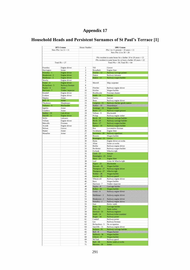
291
Appendix 17
Household Heads and Persistent Surnames of St Paul’s Terrace [1]
House Number
Fearnley Engine driver 1 Till Grocer
Harrington Joiner 2 Broadbelt Engine fitter
Priestley - 1 Engine driver 3 Towler - 12 Railway carriage painter
Henderson - 2 Engine driver 4 Dutton Railway labourer
Malthouse - 3 Engine driver 5 Hutton - 13 Railway wagon builder
Newby Engine driver 6
Foster - 4 Engine driver 7 Morrell Ship carpenter
Richardson - 5 Railway fireman 8
Naylor - 6 Joiner 9 Fletcher Railway engine driver
Harrison - 7 Timber inspector 10 Kitchin Wagon builder
Kendall Engine driver 11 Braithwaite Foreman shunter
Graham Engine driver 12 Smith - 14 Sawyer
Shipley Joiner 13 Darley Sawyer
Bell - 8 Joiner 14 Bean Railway engine driver
Theakston Shopkeeper 15 Campion - 15 Railway checker goods station
Vallance - 9 Blacksmith 16 Stabler - 10 Housekeeper
Ingleby Joiner 17 Armitage - 16 Wagon builder
Gladders Joiner 18 Byers - 17 Railway wagon greaser
Stabler - 10 Cab driver 19 Vallans - 9 Blacksmith
Sutcliff - 11 Engine driver 20 Pickup Railway engine stoker
Wells Labourer 21 Birch - 18 Railway carriage builder
Vollans Engine driver 22 Birch - 18 Railway carriage builder
Metcalfe Fireman 23 Byers - 17 Railway wagon builder
Acomb Engine driver 24 Spence - 19 Railway wagon builder
Nelson Grocer 25 Roe Locomotive fireman
Hunter Joiner 26 Swinburne Engine fitter
Monallee Joiner 27 Starsmore - 20 Railway signalman
28 Bowers Wagon builder
29 Binnington - 21 Grocer
30 Bains Engine driver at works
31 Allatt Joiner at works
32 Bielby Railway engine driver
33 Rochester Railway wagon builder
34 Ewbank Wheelwright
35 Clark - 22 Sawyer
36 Dunnington - 23 Joiner
37 Shaw - 24 Engine fitter
38 Leaf Joiner & Wheelwright
39 Alport - 25 Blacksmith
40 Neesam - 26 Wagon builder
41 Thompson - 27 Railway engine driver
42 Thompson - 27 Wheelwright
43 Walker - 28 Wagon builder
44 Lewins - 29 Railway guard
45 Wheatcroft Railway engine driver
46 Race Wagon builder
47 Harrison - 7 Timber inspector
48 Naylor - 6 Carriage builder
49 Ridley - 30 Wagon builder
50 Foster - 4 Railway engine driver
51
52
53 Henderson - 2 Railway engine driver
54 Priestley - 1 Railway engine driver
55 East Boiler smith
56 Jones - 31 Carriage builder
57 Flint - 32 Bank cashier
58 Davison - 33 Railway engineer
59 Smith - 14 Railway ticket examiner
60 Hague - 34 Railway porter
61 Cundall Railway porter
62 Lee Railway fireman
63 Richardson - 5 No occupation
64 Sutcliffe - 11 Railway engine driver
65 Jackson - 35 Railway carriage builder
66 Bell - 8 Wagon builder
67 Skilbeck - 36 Wagon builder
68 Gibson - 37 Wagon builder
69 McTurk Railway guard
70 Hall - 38 Boiler smith at works
71 Marston - 39 Joiner
Malthouse - 3 Railway engine driver
Total IFs = 27 Total PSs = 39; Total IFs = 64
PSs resident in same house for a further 10 to 20 years = 13
PSs resident in same house for at least a further 20 years = 22
New PSs 12 to 39 = 28
New PSs 1 to 11 = 11 PSs 1 to 11 present > 10 years = 11
1871 Census 1881 Census

292
Household Heads and Persistent Surnames of St Paul’s Terrace [2]
House Number
1 Scaife Grocer Calvert Grocer shopkeeper & Post mist
2 Simpson - 40 Railway stoker Grimshaw Joiner
3 Towler - 12 Coach painter Towler - 12 Railway carriage painter
4 Dobson - 41 Railway waggon builder Blackford Joiner
5 Stabler - 10 Gardener Domestic servant Entwistle Railway timber inspector
6 Marshall - 42 Labourer Marshall - 42 Railway wagonshop labourer
7 Dunnington - 23 Labourer Johnston *Coach body worker
8 Peckitt Joiner Fletcher Railway guard
9 Smith - 14 Labourer Stamp Laundress
10 Kitchen - 43 Waggon builder Hill Widow
11 Hall - 38 Carriage trimmer Fratson Railway wheelwright
12 Clare Stationery engine driver Siddell Blacksmith
13 Wardman Railway clerk Dobson - 41 Railway blacksmith
14 Cook - 44 Locomotive engine driver Hutton - 13 Railway goods porter
15 Campion - 15 Railway clerk Holmes Railway carriage painter
16 Stabler - 10 Lets lodgings Armitage - 16 Colliery agents clerk
17 Armitage - 16 Railway waggon builder Balme Sawyer (Wood)
18 Byers - 17 Waggon wheel turner Byers - 17 Railway wagon wheel turner
19 Jones - 31 Fitter Jones - 31 Railway locomotive engine fitter
20 Smithson Cabinet maker Humphreys Railway stationary engine driver
21 Birch - 18 Joiner Birch - 18 Joiner
22 Simpson - 40 Railway waggon builder Brown Blacksmith
23 Simpson - 40 Railway signal fitter Simpson - 40 Railway signal inspector
24 Spence - 19 Joiner Spence - 19 Joiner
25 Severs Railway waggon builder Pennock Railway joiner
26 Baines - 45 Labourer Baines - 45 Railway engine stoker
27 Starsmore - 20 Takes in lodgers Harsmore Widow
28 Deeke Joiner Terry Sawyer
29 Binnington - 21 Lets lodgers & shopkeeper Chappell Widow
30 Wedgwood Blacksmith Shaw - 24 Railway coach builder
31 Malthouse - 3 Locomotive engine worker Woodfell Railway carriage joiner
32 Buttle Living on own means Hodgson - 47 Wife resident; husband absent
33 Robinson - 46 Groom Burnett Cabinet maker
34 Alport - 25 Blacksmith Kitchen - 43 Joiner
35 Clark - 22 Sawyer Campion - 15 Railway checker goods station
36 Smith - 14 Carriage builder Maddison Railway clearing house number taker
37 Shaw - 24 Engine fitter retired Shaw - 24 Printer compositor
38 Hession Railway blacksmith
39 Alport - 25 Blacksmith Ibbitson Railway wagon inspector
40 Neesam - 26 Waggon builder Neesam - 26 Railway wagon prepairing
41 Haithwaite Blacksmith Smith - 14 Joiner
42 Thompson - 27 Joiner* Thompson - 27 Railway wagon builder
43 Walker - 28 Joiner Walker - 28 Joiner
44 Lewins - 29 Railway guard Byrne - 49 Railway foreman carriage shop worker
45 Hodgson - 47 Railway engine driver Hodgson - 47 Railway engine driver
46 Thompson - 27 Coachman & gardener Thompson - 27 Coachman gardener
47 Smith - 14 Engine driver Simpson - 40 Railway foreman porter
48 Naylor - 6 Joiner Naylor - 6 Joiner
49 Ridley - 30 Joiner Dunnington - 23 Widow
50 Foster - 4 Widow Foster - 4 Widow
51 Malthouse - 3 Shoemaker Malthouse - 3
52 Malthouse - 3 Locomotive engine driver
53 Henderson - 2 Lets lodgings Simpson - 40 Railway wagon builder
54 Priestley - 1 Lets lodgings *Beel Railway signalman
55 Hutton - 13 Railway waggon builder Hutton - 13 Joiner
56 Eckels Railway signalman Byrne - 49 Railway coach plummer
57 Gibson - 37 House carpenter Robinson - 46 Railway carriage wheelwright
58 Davison - 33 Railway engine driver Davison - 33 Railway locomotive engine shed
59 Smith - 14 Railway ticket examiner Smith - 14 Railway ticket examiner York station
60 Hague - 34 Railway porter Hague - 34 Railway passenger guard
61 Flint - 32 Retired laundress Cook - 44 Railway locomotive engine fitter
62 Wilmin - 48 Railway shunter Wilmin - 48 Railway traffic foreman
63 Byrne - 49 Railway coach builder Lewins - 29 Widow
64 Arthington Railway carriage smith Moss Joiner
65 Jackson - 35 Joiner Jackson - 35 Joiner
66 Bell - 8 Joiner Barnes General labourer out of work
67 Skilbeck - 36 Joiner Skilbeck - 36 Railway steam engine maker fitter
68 Gibson - 37 Waggon builder Gibson - 37 Joiner
69 Harker Railway porter Mann Railway goods shunter
70 Hall - 38 Boiler smith Hall - 38 Boilersmith
71 Marston - 39 Wife resident; husband absent Lilley Widow
Not stated
Total PSs = 45; Total IFs = 58 Total IFs = 62
PSs resident in same house for at least a further 10 years = 26
PSs 12 to 39 present > 10 years = 28 PSs 12 to 39 present > 20 years = 21
New PSs 40 to 49 = 10 PSs 40 to 49 present > 10 years = 9
PSs 1 to 11 present > 20 years = 7 PSs 1 to 11 present > 30 years = 3
1891 Census 1901 Census

293
Appendix 18
Household Heads and Persistent Surnames of Railway Terrace [1]
House Number
Garretty Engine driver 1 Middleton Shoemaker
Shaw Engine driver 2 Grainger Railway engine driver
Dilworth Waggon builder 3 Dickens Railway signalman
Talbot Smith 4 Rotherham - 2 Engine fitter
Holborn - 1 Engine driver 5 Rotherham - 2 Dressmaker
Blakey Smith 6 Linfoot Wagon builder
Wiseman Engine driver 7 Raper - 3 Railway clerk
Hill Foreman railway 8 Dunnington Joiner & Wheelwright
Coop Waggon builder 9 Wilson Boarding house keeper
Gibson Engine driver 10 Webster - 4 Butcher
Coulson Smith 11 Bradley Cabinet maker
Clayton Labourer 12 Rayson - 5 Bricklayer
13 Morrallee - 6 Joiner
14 Middleton Railway wagon builder
15 Arnett - 7 Wheelwright
16 Watson - 8 Engine fitter
17 Gawthorpe Engine fitter
18 Chipchase - 9 Cabinet maker
19 Freeman - 10 Plumber
20 Peckitt Wagon builder
21 Race - 11 Wagon builder
22 Hall Foreman labourer
23 Holborn - 1 Railway engine driver
24 Denterman Engine fitter
25 Creaser Machine fitter
26 Cooper - 12 Wagon builder
27 Stephens Former wheelwright
28 Gray - 13 Railway truck maker
29 Hopper Engine fitter
30 Edwards - 14 Carriage spring maker
31 Parkin - 15 Wagon builder
32 Rennison - 16 Retired grocer
33 Sharpe
New PSs = 1 PS 1 present > 10 years = 1
1871 Census 1881 Census
New PSs 2 to 16 = 15
PSs resident in same house for a further 10 to 20 years = 7
PSs resident in same house for at least a further 20 years = 9
Total IFs = 12 Total PSs = 16; Total IFs = 32

294
Household Heads and Persistent Surnames of Railway Terrace [2]
House Number
1 Hale Railway carriage builder Milner Railway Coach painter
2 Brown - 17 Joiner Hunt Joiner & Wheelwright
3 Gibson Joiner Mann Railway Goods porter
4 Rotheram - 2 Engine fitter Rotherham - 2 Railway locomotive engine fitter
5 Noble Railway carriage builder Williamson Schoolmaster
6 Lightfoot Railway waggon builder Suter Joiner carpenter
7 Raper - 3 Retired pension clerk Bardict Railway clearing house number taker
8 Button - 18 Railway porter Button - 18 Railway porter retired
9 Johnson - 19 Railway goods porter Johnson - 19 Railway porter
10 Webster - 4 Butcher Newby Railway wagon painter
11 Taylor - 20 Engine driver Taylor - 20 Railway engine driver
12 Rayson - 5 Bricklayer King House painter
13 Morrallee - 6 Labourer Morrallee - 6 Joiner carpenter
14 Leadley - 21 Wheelwright Leadley - 21 Railway wheelwright
15 Arnett - 7 Wheelwright Birkinshaw Railway coach painter
16 Watson - 8 Engine fitter Watson - 8 Railway engine fitter retired
17 Hutchinson Railway wheelwright
18 Chipchase - 9 Joiner Chipchase - 9 Joiner, out of work
19 Freeman - 10 Laundress Arrowsmith Railway guard
20 Wade - 22 Railway guard Wade - 22
21 Coulson - 23 Coulson - 23 Railway shunter
22 Race - 11 Joiner Brown - 17 Railway wagon Wright Foreman
23 Hawkswell - 24 Painter Hawkswell - 24
24 Thackwray - 25 Blacksmith Thackwray - 25 Blacksmith
25 Stephenson - 26 Wheelwright Stephenson - 26
26 Cooper - 12 Waggon builder Cooper - 12 Railway Joiner
27 Waiting Railway waggon inspector Giddings Railway carriage painter
28 Gray - 13 Railway waggon builder Gawthrop Fitter
29 Cooper - 12 Blacksmith Cooper - 12 Blacksmith
30 Edwards - 14 Railway spring maker Edwards - 14 Railway wagon maker
31 Parker - 15 Railway waggon inspector Parkin - 15 Railway carriage and wagon inspector
32 Rennison - 16 Living on own means Clark Laundress
33 Rennison - 16 Railway shunter Rennison - 16 Railway Goods shunter
PS 1 present > 20 years = 0 PS 1 present > 30 years = 0
1891 Census 1901 Census
PSs 2 to 16 present > 10 years = 15 PSs 2 to 16 present > 20 years = 9
New PSs 17 to 26 = 10 PSs 17 to 26 present > 10 years = 10
PSs resident in same house for at least a further 10 years = 18
Total PSs = 27; Total IFs = 31 Total IFs = 33

295
Appendix 19
Household Heads and Persistent Surnames of St Paul’s Square [1]
House Number House Number House Number
1 St Pauls Square Backhouse - 1 Architect & Surveyor 1 St Pauls Square Fletcher - 2 Carpenter 1 St Pauls Fletcher - 2
2 St Pauls Square Burden Gentlewoman 2 St Pauls Square Lara Commercial traveller 2 St Pauls Oates Dividends
3 St Pauls Square Matthews Superintendent of electric telegraph 3 St Pauls Square Peacock Agent in spirits 3 St Pauls Bardsley -15 Annuity
4 St Pauls Square Dixon Landed proprietor 4 St Pauls Square Harrison Annuitant 4 St Pauls Lee Railway rating agent
5 St Pauls Square Fletcher - 2 Fundholder 5 St Pauls Square Fletcher - 2 Clergyman widow 5 St Pauls Pendleton Annuitant
6 St Pauls Square Wilkinson - 3 Clergyman's widow 6 St Pauls Square Wilkinson - 3 Annuitant 6 St Pauls Wilkinson - 3 Dividends
7 St Pauls Square Sanderson Timber & slate merchant 7 St Pauls Square Mosley Teacher
8 St Pauls Square Wainwright Vicar of Holy Trinity Micklegate 8 St Pauls Square Newby Commercial traveller 8 St Pauls Wheeler Commercial traveller
9 St Pauls Square Jennings - 4 Manager of sack dept NER 9 St Pauls Square Jennings - 4 Railway manager 9 St Pauls Halley* Annuitant
10 St Pauls Square Hardy Retired farmer 10 St Pauls Square Walton - 10 10 St Pauls Walton - 10 Dividends
12 St Pauls Square Boddy Artist in water colour 12 St Pauls Sargent Wesleyan Minister
13 St Pauls Square Gill - 5 Clerk 13 St Pauls Gill - 5 Dividends
15 St Pauls Square Gill - 5 Railway cashier
16 St Pauls Square Sanderson *Master of 47 Regiment 16 St Pauls Square King Commission agent 16 St Pauls Oliver - 16 Locomotive fireman
17 St Pauls Square Cass Landed proprietor 17 St Pauls Square Inman - 11 Manager horse dept NER 17 St Pauls Grubb Teacher
18 St Pauls Square Perkins - 9 Attorney Registrar of York County Court 18 St Pauls Perkins - 9 Solicitor
St Pauls Square Ask Teacher 19 St Pauls Farrill* Ironmonger
St Pauls Square Wilson - 6 Goods manager NER 20 St Pauls Inman - 11` Railway Superintendent
St Pauls Square Calvert Contractor 21 St Pauls Wilson - 6 Mahogany Merchant
St Pauls Square Sanderson Fundholder 22 St Pauls Jasper* Coal merchant
St Pauls Square Jackson - 7 Lodging house keeper 23 St Pauls Proctor - 12 Ag & Chemical Manager
St Pauls Square Champeney Solicitor 24 St Pauls Square Edmundson Landowner; MA Cantab 24 St Pauls Barker Rents
St Pauls Square Cobb Fundholder 25 St Pauls Square Proctor - 12 Agricultural merchant 25 St Pauls Hill Grocer
St Pauls Square Wilson - 6 Retired tradesman 26 St Pauls Square Smythe Minister of Baptist Church
St Pauls Square Taylor - 8 Grocer Tea dealer Tradesman 27 St Pauls Square Taylor - 8 Master grocer employing 5 hands
St Pauls Square Richardson Retired merchant 28 St Pauls Square Wilson - 6 Income from houses dividends 28 St Pauls Wilson - 6 Rent of Business*
St Pauls Square Steward Comb manufacturer 29 St Pauls Square Farrington Income from dividends 29 St Pauls Pearson Landowner
St Pauls Square Perkins - 9 Attorney & Solicitor, Registrar of York County Court 30 St Pauls Adams Commercial Traveller's wife
St Pauls Square Shephard Annuitant 31 St Pauls Square Hopkins - 13 Annuitant 31 St Pauls Hopkins - 13 Interest on Money
St Pauls Square Walton - 10 Landed proprietor 32 St Pauls Square Jackson - 7
33 St Pauls Square Dinsdale - 14 Income from dividends WRONG 33 St Pauls Dinsdale - 14 Dividends
34 St Pauls Square Maude Independent 34 St Pauls Willsay* Vicar of Thorganby
35 St Pauls Square Falconer Railway inspector 35 St Pauls Collier Minister of C of E
St Pauls Square Backhouse - 1 Architect 36 St Pauls Backhouse - 1 Architect & Surveyor
PSs 1 to 10 present > 20 years = 8
1881 Census1871 Census
Total PSs = 14; Total IFs = 28
New PSs 15 to 16 = 2
PSs 11 to 14 present > 10 years = 4
1861 Census
Total IFs = 24
New PSs 1 to 10 = 10
Total PSs = 14; Total IFs = 27
PSs 1 to 10 present > 10 years = 10
New PSs 11 to 14 = 4
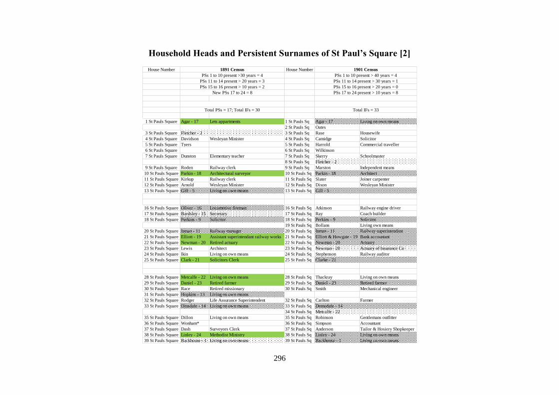
296
Household Heads and Persistent Surnames of St Paul’s Square [2]
House Number House Number
1 St Pauls Square Agar - 17 Lets appartments 1 St Pauls Sq Agar - 17 Living on own means
2 St Pauls Sq Oates
3 St Pauls Square Fletcher - 2 3 St Pauls Sq Rase Housewife
4 St Pauls Square Davidson Wesleyan Minister 4 St Pauls Sq Camidge Solicitor
5 St Pauls Square Tyers 5 St Pauls Sq Harrold Commercial traveller
6 St Pauls Square 6 St Pauls Sq Wilkinson
7 St Pauls Square Dunston Elementary teacher 7 St Pauls Sq Skerry Schoolmaster
8 St Pauls Sq Fletcher - 2
9 St Pauls Square Roden Railway clerk 9 St Pauls Sq Marston Independent means
10 St Pauls Square Parkin - 18 Architectural surveyor 10 St Pauls Sq Parkin - 18 Architect
11 St Pauls Square Kirkup Railway clerk 11 St Pauls Sq Slater Joiner carpenter
12 St Pauls Square Arnold Wesleyan Minister 12 St Pauls Sq Dixon Wesleyan Minister
13 St Pauls Square Gill - 5 Living on own means 13 St Pauls Sq Gill - 5
16 St Pauls Square Oliver - 16 Locomotive fireman 16 St Pauls Sq Atkinson Railway engine driver
17 St Pauls Square Bardsley - 15 Secretary 17 St Pauls Sq Ray Coach builder
18 St Pauls Square Perkins - 9 Solicitor 18 St Pauls Sq Perkins - 9 Solicitor
19 St Pauls Sq Bollans Living own means
20 St Pauls Square Inman - 11 Railway manager 20 St Pauls Sq Inman - 11 Railway superintendant
21 St Pauls Square Elliott - 19 Assistant superintendant railway works 21 St Pauls Sq Elliott & Howgate - 19 Bank accountant
22 St Pauls Square Newman - 20 Retired actuary 22 St Pauls Sq Newman - 20 Actuary
23 St Pauls Square Lewis Architect 23 St Pauls Sq Newman - 20 Actuary of Insurance Co
24 St Pauls Square Ikin Living on own means 24 St Pauls Sq Stephenson Railway auditor
25 St Pauls Square Clark - 21 Solicitors Clerk 25 St Pauls Sq Clarke - 21
28 St Pauls Square Metcalfe - 22 Living on own means 28 St Pauls Sq Thackray Living on own means
29 St Pauls Square Daniel - 23 Retired farmer 29 St Pauls Sq Daniel - 23 Retired farmer
30 St Pauls Square Race Retired missionary 30 St Pauls Sq Smith Mechanical engineer
31 St Pauls Square Hopkins - 13 Living on own means
32 St Pauls Square Rodger Life Assurance Superintendent 32 St Pauls Sq Carlton Farmer
33 St Pauls Square Dinsdale - 14 Living on own means 33 St Pauls Sq Demodale - 14
34 St Pauls Sq Metcalfe - 22
35 St Pauls Square Dillon Living on own means 35 St Pauls Sq Robinson Gentlemans outfitter
36 St Pauls Square Wonham* 36 St Pauls Sq Simpson Accountant
37 St Pauls Square Dash Surveyors Clerk 37 St Pauls Sq Anderson Tailor & Hosiery Shopkeeper
38 St Pauls Square Linley - 24 Methodist Ministry 38 St Pauls Sq Linley - 24 Living on own means
39 St Pauls Square Backhouse - 1 Living on own means 39 St Pauls Sq Backhouse - 1 Living on own means
PSs 1 to 10 present >30 years = 4
1891 Census 1901 Census
Total PSs = 17; Total IFs = 30
PSs 11 to 14 present > 20 years = 3
New PSs 17 to 24 = 8
PSs 15 to 16 present > 10 years = 2
Total IFs = 33
PSs 1 to 10 present > 40 years = 4
PSs 11 to 14 present > 30 years = 1
PSs 15 to 16 present > 20 years = 0
PSs 17 to 24 present > 10 years = 8

297
Appendix 20
Household Heads and Persistent Surnames of Hope Street [1]
Craven Whitesmith Liddle Out of business Jacques Foundry labourer Redpath - 66 Plumber & Glazier
Robinson Linen weaver Dixon - 24 House Holder Hebden - 41 Charwoman Smith - 12 Bricklayer
Dunnington Washerwoman Peacock - 28 Blacksmith Dalton Charwoman Scarr Grocer
Brown - 1 Shoe maker Honley Ashmore - 38 Brass founder Fox Ag lab
Craven Linen weaver Pallister Shoemaker Ryan - 42 Laundress Potter Engine fitter
King Ag lab Shepherd - 4 *Plane maker Mercer - 43 Whitesmith Bagnall - 64 Iron moulder
Ward - 2 Joiner Thompson - 5 Porter Motherby Bricklayer Coggins - 45 Ag lab
Plummer Wood sawyer Brown - 1 Shoemaker Rafter* - 44 Ag lab Duffee Labourer saw mill
Appleyard -3 Bottle maker Hayton House Holder Melody Ag lab Gaughan - 67
Bosomworth Joiner Prince - 15 Gardener Coggins - 45 Ag lab McHale - 62 Ag lab
Bowman Cabinet maker Binney Groom Dougherty Bricklayers lab Burke - 63 Ag lab
Shepherd - 4 Rope maker Mooney - 30 Glass Maker Laverty Bricklayers lab Larkin Ag lab
Thompson - 5 HS Hobson - 31 Waterman Ryan - 42 Ag lab Holmes - 52 Labourer
Boldon Glass maker Smith - 12 Benson - 27 Charwoman Steel - 68 Glass blower
Fowler Gardener Shephard - 4 Appleton Brewer Steel - 68 Glass blower
Gibson Washerwoman Berrell Boot maker Ayers* Whitesmith Stanbrook Warrener
Drake - 6 Fishmonger Simpson - 13 Annuitant Sinane* Ag lab Bennett - 61 Brickyard lab
Clarke Lint manufacturer Thompson - 5 Printer Coulter Shoe maker Duffield Groom Domestic servant
Thrush Tailor Mullingon Charwoman McCabe Pedlar Halder - 69 Retired journeyman tailor
Charlton HS Thompson - 5 Housepainter Watkinson - 37 Waterman Hudson - 56 Glass blower
Smithson Joiner Smith - 12 Tailor Watkinson - 37 Vessel owner Dent - 65 Glass blower
Slater Joiner Appleyard - 3 Glass blower Brown - 1 Fireman glass works Wells Pig jobber
James Ind Watson - 20 Joiner Hannren Mason lab Davison Charwoman
Halder - 7 Joiner Boulton Labourer Duffy Smith lab Johnson - 70 Glass blower
Driffield - 8 Linen weaver Gill - 11 Corley Ag lab Wake
Swift Stone mason Hartley - 22 Sawyer Druggitt - 39 Washer woman Benton - 71 Labourer
Hodgson Joiner cabinet maker Harwood - 10 Soldier's widow Druggitt - 39 Packer glass works Wood - 19 Ironmolder
Gowland Baker Cairns Farmer's labourer McNulty - 46 Ag lab Mills Lab
Penrose Whitehead - 9 Iron moulder Brown - 1 Charwoman O'Hara - 47 Brickmaker
Tuxworth Sawyer Hannan Police officer Brennan Ag lab Swift - 72 Iron molder
Whitehead - 9 Glass blower Bland Joiner Perry - 40 Publican Morton - 73 Joiner
Pearson Spinster Driffield - 8 Robinson Basket maker Conway - 74 Ag lab
Cattle Ag lab Halder - 7 Joiner Lamb - 17 Shoe maker Gough Railway lab
Harwood - 10 Washerwoman Kitson Cordwainer *Carey - 18 Joiner Kirby - 59 Weaver
Fawcett Glasshouse foreman Rose Milliner Turner - 26 Rope maker Bean - 75 Cabinet maker
Flathers Joiner Wells Plane maker Jennings Carter Myton -76 Whitesmith
Gill - 11 Copley Whitesmith Chambers Wheelwright Delany Ag lab
Marshall Attorney's clerk Clark Lintmaker Cook Railway lab Allen Ag lab
Wilson Spinster Thompson - 5 Late innkeeper O'Hara - 47 Corporation lab Brannan - 77 Ag lab
Kirby Linen weaver Mackalin Wireworker Slater Smith engineer Beain - 75 Labourer
Smith - 12 Tailor Clifford - 32 Brickmaker Smith - 12 Bricklayer O'Hara - 47 Iron foundry lab
Thompson - 5 Painter Whitehead - 9 Moulder O'donnell Bricklayers lab Bolland Bricklayers lab
Thompson - 5 Painter Spence Weaver Whincup - 35 Ag lab Fairfoot Gunsmith
Abbott Shop keeper Kirk - 33 Joiner Molloy Ag lab Hobson - 31 Formerly waterman
Simpson - 13 Ind Dixon - 24 Weaver Barrett - 48 Farm work Simmons - 60 Engine driver
Steel - 14 Printer Wood - 19 Whitesmith Maher Ag lab Smith - 12 Chair maker
Lloyd Letter press painter Bellis - 34 Seamstress Maher Mortimer - 57 Hawker
Slater Gardener Chapman - 29 *Manufacturer Flood Ag lab Hobson - 31 Dressmaker
Carr Cow keeper Sanger Pauper charwoman Melody Ag lab Barrett - 48 Lab iron foundry
Brown - 1 Washerwoman McKenzie Ag lab Brown - 1 Ag lab Brown - 1 Shoemaker
Prince - 15 Gardener Whincup - 35 Jones - 49 Ag lab Cuff - 78 Ag lab
Burton - 16 Cowkeeper Benson - 27 Charwoman McAndrew Ag lab Roche - 79 Ag lab
Brown - 1 Shoe maker Gledhill Jones - 49 Ag lab Martin Ag lab
Thompson - 5 Linen weaver Pinder Goghan O'Neal Ag lab
Spenceley HS Henessy Charwoman Welsh Licensed hawker Shepherd - 4 Shop keeper
Heilds Gardener Wilberforce - 36 Gardener Conaughton Porter brewery Meek Labourer in Ironwork
Lamb - 17 Shoe maker Steel - 14 Tailor Gill - 11 Ag lab Shillito - 50 Glass maker
Carey - 18 Ind Watkinson - 37 Coal merchant Sullivan Laundress Barnacle Labourer
Handley Ind Mooney - 30 Glass maker James Shoe maker Dale Printer compositor
Wilson Shopkeeper Burton - 16 Charwoman Wood - 19 Waterman Dale Whitesmith
Collins Stone mason Parnaby Ag Lab Shillito - 50 Glass maker Horsman - 80 Linen weaver
Wood - 19 Ag lab Beach Brush maker Beal - 23 Navesby Bricklayers labourer
White Tailor Rochester Moulder Meynell Ag lab Doherty Railway lab
Watson - 20 Waterman Ashmore - 38 Pauper charwoman McGovern Bricklayers lab McNulty - 46 Ag lab
Vant Tailor Brown - 1 Shoemaker Ryan - 42 Ag lab McHale - 62
Vant Tailor Druggitt - 39 Charwoman Lyden - 51 Ag lab Benson - 27
Beeth Millwright Atley Charwoman Holmes - 52 White smith Johnson - 70 Joiner
Smailes Linen weaver Swann Glass maker Sharp Shoe maker Walden* Bricklayers labourer
Buttery - 21 Shoe maker Perry - 40 Book binder Rodes - 53 Whitesmith Duggan Ag lab
Total PSs = 50; Total IFs = 119 Total PSs = 58; Total IFs = 111Total IFs = 97 Total PSs = 41; Total IFs = 93
New PSs 42 to 65 = 24 PSs 42 to 65 present > 10 years = 24
New PSs 66 to 90 = 25
New PSs 30 to 41 = 12
PSs 1 to 29 present > 20 years = 14
PSs 30 to 41 present > 10 years = 12
New PSs 1 to 29 = 29 PSs 1 to 29 present > 10 years = 29
1841 Census 1851 Census 1861 Census 1871 Census
PSs 1 to 29 present > 30 years = 6
PSs 30 to 41 present > 20 years = 3

298
Household Heads and Persistent Surnames of Hope Street [2]
Laverick Tailor Turner - 26 Rope maker Kirk - 33 Joiner Gilligan - 81 Ag lab
Byers Glass blower May Pauper schoolmaster Inglein* Egan Field lab
Hill Glass maker Passmore Shoemaker Chelsea Pensioner Parkinson Huckster Gough Bricklayers lab
Hill Glass maker Passmore Glass maker Melody Bricklayers lab Hannon Foundry lab
Hartley - 22 Washerwoman Carey - 18 Carpenter Jordan - 54 Benson - 27 Bricklayers lab
Vause Joiner Tate Railway * Smith - 12 Chair maker Codley - 82 *
Carr Shoe maker Stasle* Chelsea pensioner Lambert - 55 Packer glass works Haynes *
Suffill HS Miller Whitesmith labourer Clifford - 32 Sawpit labourer Caverney Gardeners lab
Beal - 23 Cow keeper Sanderson Pauper charwoman Watson - 20 Dress maker Welch Gardeners lab
Lightfoot Ag lab Brown - 1 Collinson * Maker Battle - 83 Ag lab
Prest Stone mason Duigles* Bricklayer labourer Wingfield* Shop* Egan Ag lab
Rea Shoe maker Dobson Carpenter Cole* Whitesmith journeyman Moran Bricklayers lab
Payne Glass blower Cowling Tailor Ward* - 2 Falkeny - 84 Ag lab
Sayer Carpenter Howard Railway porter Lamb - 17 Ag lab Lyden - 51 Gardener
Dixon - 24 Washerwoman Flasher* Dressmaker Audly* Glass maker* Druggitt - 39 Railway lab
Rider Labourer Mitchell - 25 Retired proprietor of houses McCabe Dealer in brushes Graham Ag lab
Mitchell - 25 Waterman Martin Charwoman Shepherd - 4 Plane maker Mc* Railway lab
Martindale Tailor Ward - 2 Plaitlayer Gannon Ag lab Perry - 40 Licensed victualler
Beilby Cabinet maker Hebden - 41 Railway labourer Ryan - 42 Ag lab Betchetle Figure maker
Buckle Book keeper Newton Blacksmith McNab Works in fields Crane Ag lab
Habbishaw Bricklayer Dixon - 24 Groom Flannaghan Ag lab Foy Ag lab
Bistney Bricklayer Donaldson Laundress Brown - 1 Grocer shop Igo - 58 Drainer
Green Cooper Dale Assistant keeper railway Prince - 15 Boot maker journeyman Rivell Bricklayers lab
Webster Washerwoman Sweeney Ag lab Hudson - 56 Joiner at railway Jones - 49 Foundry lab
Dixon - 24 Linen weaver Beal - 23 Proprietor of houses Mortimer - 57 Licensed hawker Ryan - 42 Gardeners lab
Watson - 20 Joiner Lawler* Ag lab Wilson Shop keeper Kirby - 59 Tailor
Carey - 18 Joiner Duckworth Tailor Barnett Warehouseman Mercer- 43 Spike maker foundry
Barnett Shoe maker Morgan Glass maker Hobson - 31 Cuffie* - 78 Ag lab
Syton Washerwoman Halder - 7 Joiner James Silk & weav cleaner Gill - 11 Ag lab
Fletcher HS Fremington* Blacksmith Storey Farm lab Simpson Ag lab
Turner - 26 Rope maker Drake - 6 Glass maker McDonald Ag lab May Gardener
Birbeck Publican Lamb - 17 Brickmaker Heigo - 58 Ag lab Roche - 79 Ag lab
Whitehead - 9 Glass blower Marton Bricklayer Dagnell Railway lab Wincup Ag lab
Nicholl Stone mason Buttery - 21 Cook Handley Crollay* Field lab
Nappy Sanderson Gardener Forrester Brick lab Rafter* - 44 Ag lab
Syers Whitesmith Perfect Harness maker Jordan - 54 Nevell Field lab
Benson - 27 Shop keeper Waddington Fitter* Mooney - 30 Glass maker Quill*
Wise Gardener Pemberton Dressmaker Smith - 12 Tailor Wes local preacher Jordan - 54 Ag lab
Watters Bricklayers labourer Palliser Tailor Kirby - 59 Linen weaver Fox Ag lab
Thompson - 5 HS Brown - 1 Coach lace weaver Watson - 20 Joiner Jones - 49 Ag lab
Peacock - 28 Whitesmith Watson - 20 Pauper waterman Norwood Laundress Caveney Ag lab
Chapman - 29 Cow keeper Hopwood Gardener Coniton - 85 Ag lab
Myers Dress maker Gill - 11 Shop keeper Nicholson - 86 Ag lab
Pecks Line reeler Bailey Journeyman Trees Blacksmith
Beahon Bricklayer lab Grady Field lab
Benson - 27 Brickmaker Ryley - 87 Foundry lab
Wilberforce - 36 Green grocer Mennell - 88 Ag lab
Collins Flint glass blower Abbey - 89 Foundry lab
Huch Confectioner Calvert - 90 Joiner
Rhind Ag lab Williamson Foundry lab
Hicks Miller Metcalfe Foundry lab
Gordon Ag lab Rhodes - 53 Whitesmith
Bell Shopkeeper Bedford Linen weaver
Sturdy Blacksmith Myton - 76
Simmons - 60 Lab Wells Provision dealer
Holden House proprietor Barrett - 48 Ag lab
Donnelly Hawker Whitehead Shoe maker
Driffield - 8 Parish relief Lambert - 55 Railway lab
Bennet - 61 Lab Clark Printer compositor
Kelly Shopkeeper McGreaves Tailor
Dygnin Ag lab Belchette Glass blower
McHale - 62 Ag lab
Dagerty Bricklayer lab
Burke - 63 Lab in fields
Burke - 63 Ag lab
Lacklan Ag lab
Spackman Straw bonnet maker
Bagnall - 64 Iron moulder
McAnalty Ag lab
Mellor Labourer at Foundry
Smith - 12
Dent - 65 Tailor
Wood - 19 Journeyman
Bellis - 34 Income from Friends Soc
1841 Census 1851 Census 1861 Census 1871 Census

299
Household Heads and Persistent Surnames of Hope Street [3]
Horsman - 80 Linen weaver Watson - 114 Labourer Cook - 126 Farm labourer
Waverly Bricklayers labourer Rennie Private Royal Hussars Hughes Bricklayers labourer
Skidington Bricklayers labourer Shanks Bricklayers labourer Tiggles* Bricklayers labourer
Calpin - 91 Bricklayers labourer Dalton - 103 Living on own means Severs Groom
Birk Haw Glass bottle drier Grogan - 95 Lodging House Keeper
Storey Ag lab Henry - 110 Bricklayers labourer Sanderson House painter
Falkeny - 84 Gardeners labourer Calvert - 90 Confectioner Pawson - 125 Provision dealer
Calpin - 91 Bricklayers labourer Deighton Domestic servant Brady - 102 Plumbers labourer
Walder Bricklayers labourer Barrett - 48 Hawker McAndrew Bricklayers labourer
Flanigan - 92 Igo - 58 Thompson Bricklayers labourer
Flanigan - 92 Ag lab Beasty* - 115 Labourer Cahill Railway platelayers labourer
McGough - 93 Bricklayers labourer Ryan - 42 Gardener Haddakin
Flannery - 94 Bricklayers labourer Coggins - 45 Labourer Quigley Bricklayers labourer
Alderman Ag lab Mortimer - 57 Hawker Cawley Tailors machinist
Gill - 11 Ag lab Coughlin Labourer Elmer Railway carriage fitter
Druggitt - 39 Water works lab Calligan Labourer Harrison - 118 Farm labourer
Grogan - 95 Wright Organ case maker Clarke
Botchette Figure maker McAndrew - 116 Labourer Hick - 123 Retired gas fitter
Perry - 40 Butcher & Public Boland - 104 Bricklayers labourer Corcoran - 99 Farm field worker
Ryan - 42 Market gardener Law - 117 Labourer Steel - 68 Glass bottle maker
Jones - 49 Railway labourer Baines Labourer Stoir* Railway engine fitter
Croffee* Railway lab Brannan - 77 Labourer Beasty - 115 General labourer
Neales Bricklayer Whinn Labourer Ruckledge Agricultural labourer
Igo - 58 Ag lab Harrison - 118 Plumber Brannon - 77 Bricklayers labourer
Toy - 96 Neapsey Labourer Coulin
Odonnell - 97 Bricklayer labourer Odonnell - 97 Labourer Calpin - 91 Bricklayers labourer
Mercer - 43 Bottle washer Kirby - 59 Tailor Timms* Bricklayers labourer
Thorpe Shoe maker Cuff - 78 Labourer Jones - 49 Agricultural labourer
Pratt Ag lab Carr - 119 Labourer Gearing General labourer
Roche - 79 Confectioner Cowton* Smith - 12
Squires Charwoman Exelby - 106 Bricklayer Creaser Glass bottle worker
Oneil Bricklayer labourer Nightingale - 120 Glass bottle stopper Druggist General labourer glass works
Jordan - 54 Ag lab Flannery - 94 Bricklayers labourer McGough - 93 Field worker on farm
Conlin - 98 Ag lab Dawes Ag lab Phillips Organ grinder
Malley Ag lab Toy - 96 Labourer McDonald - 124 Farm labourer
Robinson Foundry lab Dawes Labourer Recchia Street musician
Corcoran - 99 Bricklayer lab Cooper Charwoman Annonis Street musician
Jones - 49 Ag work Armstrong - 121 Provision dealer Martino Street musician
Cavanagh - 100 McGough - 93 Labourer Swann Inn keeper
Coniton - 85 Ag lab Groghan Calpin - 91 Bricklayers labourer
Kevell Field work Holder Annuitant Bloom Bricklayers labourer
Bond Carpenters lab Grant Laundress Quinn Field worker
Snape - 101 Foundry lab Melvin Works in the fields Langan
Brady - 102 Bricklayer lab Roddy Labourer Saddler
Riley - 87 Iron moulder Battle - 83 Labour contractor Calpin - 91 Soldier
Mennell - 88 Ag lab Walden Labourer Cavanagh - 100 Gardeners labourer
Abbey - 89 Corporation lab Hancock - 122 Gardener Flanagan - 92 General farm labourer
Calvert - 90 Joiner Smith - 12 Labourer Murray Pig dealer (Assistant)
McConnill Boiler smith McHale - 62 Labourer Hogan - 113 Labourer saw mill
Abbey - 89 Confectioner Goughan - 67 McDonald - 124 Field worker
Flanigan - 92 Bricklayers lab Snape - 101 Labourer Rhodes
Dalton - 103 Shop keeper Caully Labourer Rowan - 107 Coal dealer
Barret - 48 Ag farm work Rowley Green grocer Varley Field worker
Grogan - 95 Lodging house Gains Hawker Barlow Bottle cleaner
Rider Dowdle Traveller Taylor Hawker
Willis Confectioners lab Roberts Chimney sweep Leadley General railway labourer
Nicholson - 86 Striker Gaughan - 67 Labourer Bowyer Bus driver
Pinder Railway lab Welsh - 112 Labourer Schofield General labourer
Kirby - 59 Forge man Jones - 49 Sack mender Flanagan - 92 Farm labourer
Hughes General labourer Pipes Sevant Kilmartin Labourer (Coal merchant)
Curtiss Bricklayers labourer Dickenson - 108 Horse dealer Heselwood
Snape - 101 Ironworks labourer Myers - 109 Provision dealer Horseman Firewood dealer
Redpath - 66 Gass fitter Horsman - 80 Labourer Houlson Railway goods porter
Denney Confectioner Roddy Watson - 114 Brewer's labourer
Shepherd - 4 Shopkeeper McGoff Living on own means Gleur* Seaforger*
Lazenby Pauper Sissons Laundress Smith - 12 Bottle labler
Grackan Rowan - 107 Labourer Marsdon Cocoa & Chocolate maker
Thompson Welsh - 112 Gardener Appleton General labourer
Sunderland Packer glassworks Calpin - 91 Bricklayers labourer Jackson Glass worker
Total PSs = 68; Total IFs = 112 Total PSs = 62; Total IFs = 105
1881 Census
PSs 1 to 29 present > 40 years = 4
PSs 30 to 41 present > 30 years = 2
PSs 42 to 65 present > 20 years = 14
PSs 66 to 90 present > 10 years = 25
New PSs 91 to 113 = 23 PSs 91 to 113 present > 10 years = 23
New PSs 114 to 128 = 15
1891 Census
PSs 1 to 29 present > 50 years = 3
PSs 30 to 41 present > 40 years = 1
PSs 42 to 65 present > 30 years = 10
PSs 66 to 90 present > 20 years = 10
PSs 42 to 65 present > 40 years = 3
PSs 66 to 90 present > 30 years = 7
Total IFs = 103
1901 Census
PSs 1 to 29 present > 60 years = 1
PSs 91 to 113 present > 20 years = 10
PSs 114 to 128 present > 10 years = 15
PSs 30 to 41 present > 50 years = 0

300
Household Heads and Persistent Surnames of Hope Street [4]
Perry - 40 Bottle tester glassworks Myers - 109 Coal dealer White Bricklayers labourer
Brown - 1 Assistant overseer Rowan - 107 Brick maker Ryan - 42 Worker on farm
Caspar General labourer Wilson Charwoman Coggans
Brady - 102 Bricklayers labourer Calpin - 91 Labourer Roach Bricklayers labourer
Mortimer - 57 Hawker Cavanagh - 100 Labourer Mortimer - 57 Hawker
Peacock Iron moulder Perry - 40 Labourer Falkney Bricklayers labourer
Simmons - 60 Stocker Codley - 82 Labourer Pawson - 125 General labourer
Halson Mantlemaker Jones - 49 Labourer Sibbitt Railway labourer
Cuffee - 78 Railway lab McGoff Charwoman Hope Waterman barge
Boland - 104 General lab Mercer - 43 Working at glass works Bolan Bricklayers labourer
O'Hara - 47 Lab Ironworks Devill Coal labourer Turner Charwoman
Bean - 75 Ag lab Fannon Labourer NER Raftery - 128 Bricklayers labourer
Brannan - 77 Ag lab Conlin - 98 Labourer Toker Shopkeeper
Duffey - 105 General lab Allan Licensed Hawker Heffernan - 127 General labourer
Mary Corcoran - 99 Labourer Precious Iron moulder
Morton - 73 Joiner Hick - 123 Gas fitter Law - 117 General carter
Bean - 75 Cabinet maker Forrester Labourer Battle - 83 Bricklayers labourer
Kirby - 59 Packer McDonald - 124 Labourer Cuff - 78 General labourer
Cliffe General lab Harrison - 118 Labourer Carr - 119 Garden labourer
Conway - 74 Ag lab Mennell - 88 Hawker Codley - 82 Plasterer
Myton - 76 Simmons - 60 Calpin - 91 General labourer
Exelby - 106 Bricklayer Calvert - 90 Joiner Nightingale - 120 Smith's striker
O'Hara - 47 Brickmaker Baines Plasterer Bartle Blacksmith
Shaw General lab McKale Labourer NER Duport General labourer
Ridsdill Dressmaker Flanagan - 92 Labourer Falkner Rope maker
Benton - 71 Labr Brickyard Gunning Labourer Letby Glassblower
Bielby Grinder Squire Forewoman Maher Bricklayers labourer
Johnson - 70 Glassblower Pawson - 125 Labourer Horsman - 80 Furnaceman at Brickyard
Dawson Pauper Faulkener Farm labourer Armstrong - 121 Grocer shopkeeper
Steel - 68 Farmers daughter retired Grogan - 95 Charwoman Sapcote
Lister Provision dealer Walsh Labourer Calpin - 91 Bricklayers labourer
Smith - 12 Printer compositor Brady - 102 Labourer Grogan - 95 Bricklayers labourer
Clifford General lab Johnson - 70 Laundress Schofield Boot and shoe maker
Halder - 69 Retired tailor Cook - 126 Labourer Morrell Caol hawker
Rowan - 107 Slater Delaney Farm labourer Myers - 109 Bricklayer
Nelson Confectioner Heffernan - 127 Farm labourer Gaughan - 67 General labourer
Bennet - 61 General lab Shepherd - 4 Glass blower Battle - 83 Worker on farm
Battat Grocer & provision dealer Calpin - 91 Works in the fields Gaughan - 67 General labourer
Gilligan - 81 Bricklayers lab Igo - 58 Labourer Smith - 12 Worker on farm
Kneavsey Raftery - 128 Bricklayers labourer Wood Glassblower's labourer
Gaughan - 67 Allan Works in the fields Hancock - 122 Gardener
McHale - 62 General lab Roche - 79 General labourer Pagett General labourer
Burke - 63 General lab Duffy - 105 Bricklayers labourer Cawley Builder's labourer
Gaughan - 67 Pensioner Brannon - 77 Labourer Martino Street musician
Burke - 63 Bricklayer Calpin - 91 General labourer Smith - 12 Iron worker*
Coggins - 45 Labourer Gill - 11 General labourer Goulding Bricklayer's labourer
Dickenson - 108 Labourer Crane Labourer Ashworth General dealer shop
Daudican* Labourer Kitchin General labourer Murphy Bricklayer's labourer
Ryan - 42 Glassblower Jacques - 111 Fitter* Smith - 12 General labourer
Mealy Bricklayers labourer Bradley Hawker Sparkes
Myers - 109 Shopkeeper Hart General labourer Ward General labourer
Henry - 110 Bricklayers lab O'Conner Farm labourer McFarrland*
Codley - 82 Ag farm work Hogan - 113 Labourer
Jaques - 111 Smith lab Shread Works in the fields
Cavanagh - 100 Ag lab
Swift - 72 Bricklayer lab
Battle - 83 Ag lab
Battle - 83
Welsh - 112 Gardeners lab
Hogan - 113 Ag lab
Rowan - 107 Bricklayer lab
1901 Census1881 Census 1891 Census

301
Appendices 20 and 21
Household Heads and Persistent Surnames of Hope Street and Long
Close Land
The isonymic heads of household of Hope Street and Long Close Lane are named in
Appendices 20 and 21. A persistent surname (PS) is defined as the same surname
which was present as a household head in two or more consecutive censuses. The
persistent surnames are identified in the boxes coloured green and in boxes shaded with
a stippled pattern. A box coloured green signifies the first occasion on which a
household head with a persistent surname was present in the census years, and the
persistent surnames are numbered sequentially in these boxes by the order in which they
first appeared in the censuses. A stippled box signifies the occasions on which a
persistent surname appeared in subsequent censuses. The houses were not numbered
consistently by the census enumerators, and it is not possible therefore to identify with
confidence the same house over different censuses. (* denotes an illegible word in the
census schedule.)
The data in these Appendices have been used in the mapping of families in Figure 38.

302
Appendix 21
Household Heads and Persistent Surnames of Long Close Lane [1]
Bilsond Gardener Whitingstone Pauper charwoman Calpin - 18 Ag Lab Wells - 21
Dalby Coach Lace Weaver French Glass Cutter Caveny Farm work Copley - 12 Printer
Kirk MacDonald Stone Moulder Johnson Joiner Strangeway - 22 Jobbing Smith
Kirby Linen weaver Giles Whitesmith Johnson Glass blower Coughlin Foundry lab
Passmake Shoe maker Vause Joiner Debnam Confectioner Cowling - 34 Tailor
Page Ag Lab Milner Iron turner Welsh Ag Lab Bomans *
Reed Glass blower Smith - 1 Publican Calpin - 18 Ag Lab Redpath - 23 Wood turner
Haddlesay Ag Lab Jackson Pauper Charwoman Padden Bricklayer Lab Taylor - 35 Farmers lab
Bowland Linen weaver Gibson - 9 Coach Lace Weaver Walder Bricklayer Lab Sanderson - 24 Tailor
Bellis Ind Watkinson - 8 Upholstress Musgrave Washerwoman McNulty
Selby Blacksmith Dixon Hawkers wife Byers - 11 Glass Blower Swift Foundry Lab
Littlewood Waterman Price - 5 Glass cutter Creely Pauper surveyor wife Kelly - 20 Ag Lab
Reed Washerwoman Ward - 10 Sarjeant west yorks militia Saylor Tan yard labourer Mcdonald - 19 Moulder & publican
Snell Ag Lab Byers - 11 Glass maker Beal Coal dealer Olley
Smith - 1 Book keeper Buckle - 3 Bricklayer Hurworth Groom Pullan Dressmaker
Howard Linen weaver Mooney Glass maker Betchette Plaster figure maker Riley - 36 Police Constable
Meara Coach maker Brownbridge Proprietor of houses Betchette Glass bottle maker Preetvies Shoe maker
Filon Bricklayer Copley - 12 Painter Jewitt Charwoman Ward - 10
Sturdy - 2 Joiner Aniol *Fire man (Glass works) Nahry Ag Lab Kelly - 20 Green grocer
Simpson U.S. Willison Joiner Logans Dunnell Pensioner *
Harrison Tailor Kurn Laundress Dent Stone mason Fannon - 37 Railway labourer
Richardson Chairman *Scoville Glass maker Duggan - 17 Ag Lab Byrne Plasterer
Wood U.S. Sunderland - 13 Glass maker Mcdonald - 19 Ag Lab Odonnell Glass works lab
Buckle - 3 Bricklayer Collins Glass maker Conner Fortune teller Sikes Clerk
Shepherd Rope maker Craven - 7 Seamstress Kirby Tailor Calpin - 18 Ag Lab
Waters Shoe maker Robertson Travellers wife Agar Carpenter Thorpe Shoe maker
Bowland Hunter Glass cutter Gibson - 9 Iron moulder Rowan - 38 Ag Lab
Bland Carpenter Wright Painter Benson Iron moulder Falkeney - 31 Seamstress
Pilkington - 4 Glass cutter Ryan - 6 Glass maker Ogan Ag Lab Wilson - 26 Ag Lab
Kelly Glass blower Pilkington - 4 Glass cutter Kelly - 20 Galcier Carr Gardener labourer
Price - 5 Glass cutter Foster Wells - 21 Brush maker Bowley Ag Lab
Ryan - 6 Glass maker Sturdy - 2 Smith Copley - 12 Printer Murray - 39 Brick lab
Morley Linen weaver Foster Proprietor of houses Strangeway - 22 Whitesmith Jordan - 30 Field lab
Craven - 7 Independent Bagley Police Constable Hume Glass blower Austria Labourer
Johnson Joiner Clarkson Gardener Cattle Smith Striker Maloney Brick labourer
Neville Glass maker Keach Engineer Buckle - 3 Bricklayer Kennedy - 32 Ag Lab
Watkinson - 8 Bricklayer Dixon Tailor Gledhill Brewer Lamb - 40 Field lab
Calligan Glass maker Robinson - 14 Formerly house servant Ridpath - 23 Wood turner Rutledge
Duce Joiner Briggs Cabinet maker Knox Glass blower Langan - 28 Ag lab
Kenwright Glass maker Durkin Passmore Charwoman Galagher
Hannon Chelsea Pensioner Sanderson - 24 Tailor Butler - 27 Ag lab
Sykes *Glass maker Loftus - 15 Bricklayer lab Durken - 41 Railway lab
Dwyer Tailor Molang Bricklayer lab Byley Brick lab
Thompson Ag Lab Robinson - 14 Foundry Lab Simpson Ag lab
Leyden Ag Lab Brown - 25 Publican Morris - 16 Ag lab
Wear Ag Lab Laycock Railway fitter Calpin - 18 Ag lab
Wynn Charwoman Cass Sawyer Galagher Ag lab
Mollody Ag Lab Potter Fitters lab Brannen - 33 Ag lab
Birk Charwoman Ward - 10 House proprietor Doherty Plasterers lab
Diamond Domestic housekeeper Wilson - 26 Ag Lab Kerigan* Ag lab
MacAndrew Ag Lab Lynch Ag Lab Robinson - 14 Foundry lab
Brannon Ag Lab Butler - 27 Gravel pits lab Kirk Laundress
Diamond Rowley Gravel Pit lab Harrison - 42 Coal dealer
Lofthouse - 15 Ag Lab Lister Gravel Pit Lab Lee
Sago Fieldster* Mcdonald - 19 Ag Lab Brown - 25 Glass works lab
Noon Ag Lab Rafter Ag Lab Grantham Brewers lab
Flanally Ag Lab Gologher Ag Lab Green Railway lab
Brannen Ag Lab Flinn Ag Lab Vause Shoe maker
Conway Ag Lab Cox Foundry lab Lavelle Brick lab
Brannan Bricklayers labourer Hines Charwoman Fimbin Ag lab
Morris - 16 Ag Lab Hensgen Ag Lab Casey - 29 Brick lab
Brannon Davies Bricklayers lab Dygnin - 43 Ag lab
Dugan - 17 Ag Lab Langan - 28 Ag Lab McDonald - 19 Gardener lab
Mellody Ag Lab Welsh Ag Lab Starkie Pensioner *
Casey - 29 Bricklayers lab Smith - 44 Bricklayer
Jordan -30 Ag Lab Ryan Glass blower
Sunderland - 13 Charwoman Smith - 44 Bricklayer
Lazenby Charwoman Garland Bricklayer
Harwood Rumans Railway lab
Welsh Ag Lab Perry Dress maker
Igo Musician/Fiddler Thompson - 45 Confectioner
Igo Ag Lab
Hanen Bricklayer Lab
Falkeny - 31 Ag Lab
Kennedy - 32 Ag Lab
Dunnegan Bricklayer lab
Morris - 16 Ag Lab
Morris - 16 Farm work
Halland Ag Lab
Morris - 16 Ag Lab
Brennan - 33 Ag Lab
Foy Ag lab
Calpin - 18 Gravel pit lab
Henigan Gravel pit lab
PSs 1 to 8 present > 10 years = 8
New PSs 9 to 17 = 9
New PSs 1 to 8 = 8 PSs 1 to 8 present > 20 years = 1 PSs 1 to 8 present > 30 years = 0
1841 Census 1851 Census 1861 Census 1871 Census
Total PSs = 17; Total IFs = 58Total IFs = 40
PSs 9 to 17 present > 10 years = 9
New PSs 18 to 33 = 16
Total PSs = 26; Total IFs = 74
PSs 9 to 17 present > 20 years = 4
PSs 18 to 33 present > 10 years = 16
New PSs 34 to 45 = 12
Total PSs = 32; Total IFs = 66

303
Household Heads and Persistent Surnames of Long Close Lane [2]
Brown - 25 Ag lab Constable Combworker Burke
Little Comb maker Knavsey Bricklayers labourer Rafter Glass bottle maker
McKegg Ag Farm work McAlone - 54 Publican England Labourer York Corporation
Rafftery Ag lab Duffield Mailcart driver Brannon - 33 Bricklayers labourer
Hope Coal dealer Calvert Carter & shopkeeper Fairbairn Bricklayers labourer
Allan Fitters lab Leadley - 50 Gas fitter McGuire General labourer
Henigan - 46 Bricklayers lab Redpath - 23 Glass blower McAlone - 54 Innkeeper pub
McIntyre Bricklayer lab Judson - 55 Joiner Fox Tailor
Calpin - 18 Ag lab Bagnall - 56 Iron moulder Newton Grinder Cutlery
Gologher Ag lab Igoe Bricklayers labourer Wilson Railway labourer
Morris - 16 Ag lab Strangeway - 22 Whitesmith Bissell Hawker
Kelly - 20 Bricklayers lab Jackson General labourer Harrison - 42 Bricklayers labourer
Riley - 36 Bricklayers lab Walsh - 57 Labourer Leadley - 50 Gas fitter
Durken - 41 Ag Lab Kerney General labourer Judson - 55 Railway joiner
Butler - 27 Ag lab Lunlin Dairyman Bagnall - 56 Iron moulder
Calpin - 18 Ag lab Lavelle Bricklayers labourer Bean Glass bottle maker
Calpin - 18 Ag lab Dignew - 58 Railway guard Empson Bricklayers labourer
Fannon - 37 Fitters lab McDonald - 19 Cawley Bricklayers labourer
Broadbent Foundry lab Dalton - 51 Charwoman Walsh - 57 Bricklayers labourer
Rowley Ag lab Hawksby - 49 Gardener Kenny Dairier
Gologher Ag lab Thompson - 45 Labourer Corcoran Living on own means
Lamb - 40 Railway lab Mellor - 52 Glass bottle finisher Tovelle Builders labourer
Harrison - 42 Ag lab Dale - 53 Glass blower Dignon - 58 Railway passenger guard
Duggan Pudler iron Judson - 55 Railway engine driver Thompson - 45 Railway bricklayer
Kennedy - 32 Glass works lab Taylor - 35 Engine fitter Loftus - 61 Bricklayers labourer
Kelly - 20 Scavinger Martindale - 59 House painter Wainman Cabinet maker
Jordan - 30 Ag lab farm work Parkinson Grocer Thompson - 45 Labourer (Timber yard)
Murray - 39 Mason lab Gallagher - 60 Labourer in fields Mellor - 52
White - 47 Provision dealer Murray - 39 Charwoman Dale - 53 Glass maker
Kelly - 20 Bricklayer lab Leach Bootmaker Judson - 55 ?Turner timber yard
Calpin - 18 Ag lab Calpin - 18 Labourer brickyard Taylor - 35 Railway signal fitter
Rowan - 38 Ag lab Calpin - 18 Farm labourer Martindale - 59 Charwoman
Flinn - 48 Ag lab Durkin - 41 Corpration labourer Boldison - 62 Tin Plate Worker
Fenwick Smiths lab Riley - 36 Bricklayers labourer Carty Farm labourer
Caufield Tailor Riley - 36 Bricklayers labourer Turner Labourer confectionery works
Bailey Watch maker Loftus - 61 White - 47 Living on own means
Joy Coach trimmer Hennigan - 46 Railway labourer Brammer Cok dining hall railway
McDonald - 19 Greenwood Railway sack warehouse Wilson Provision & Coal Dealer
Brannon - 33 Bricklayers lab Dale - 53 Combmaker Robertson Cattle dealers assistant
McGough Bricklayers lab Guest Hawker Murray - 39
Calpin - 18 Ag lab Flannigan Farm labourer Rowan - 38 Farm labourer
Sykes Coal agent White - 47 Stonemason labourer Richardson House painter
Hawksby - 49 Ag lab Gallagher - 60 Labourer Connaghton Bricklayers labourer
Kelly - 20 Wells - 21 Painters labourer Nolan Labourer flour mill
Collins White smith Battle Brickyard labourer Hennigan - 46 Bricklayers labourer
Hogan Ag farm work Giles Furniture dealer Flynn - 48 Labourer flour mill
Wells - 21 Brush maker Rushman Laundress Banks
Carter Tailor Gainley Bricklayers labourer Calpin - 18 Agricultural labourer
Strangeway - 22 Jobbing smith Brannon - 33 Bricklayers labourer Calpin - 18 Farm labourer
Empson Foundry lab Faulkney Rope maker Durkin - 41 Labourer York Corporation
Cauglin Bricklayers lab Obrian Hawker Riley - 36 Builders labourer
Cowling - 34 Tailor Shepherd Laundry maid Riley - 36 Bricklayers labourer
Leadley - 50 Gass fitter Saddler Charwoman Proctor Charwoman
Redpath - 23 Wood turner Harrison - 42 General labourer Gollagher - 60 Farm labourer
Potter Iron driller lab Bolderson - 62 Joiner Foy Field worker
Webster Shop keeper Chapman Iron moulder Walls
Garnett Glass works lab Dwyers Labourer Loftus - 61 Plasterers labourer
Kneasby Bricklayers lab White - 47 Lives on own means Heningan - 46 Bricklayers labourer
Murray - 39 Bricklayers lab Flynn - 48 Charwoman Oglesby Coal merchant
Reid Comb maker Rowan - 38 General labourer Thompson - 45 Railway porter
Smith - 44 Bricklayer Kennedy - 32 General labourer Calpin - 18 Bricklayers labourer
Barwick Painter Brannan - 33 General labourer Powell Railway labourer
Wilkinson Corporation Road Lab Gallager - 60 Ogram Bargeman
Sullivan Bricklayers lab Bell Wheelwright De Laney Field worker
Hart Ag lab Cartwright General labourer Fawcett Labourer cocoa works
Tose Ag farm work Oxtoby House painter McNichol General labourer
Cosgrove Bricklayers lab Hardy Chimney sweep
Rowan - 38 Bricklayers lab Milne Labourer Brickyard
Kenny Corporation lab roads Allen Army reserve (Farm labourer)
Simlin Bricklayers lab Calpin - 18 Yard man in farm
Casey - 29 Bricklayers lab Matchett Porter post office
Dygnin - 43 Dalton - 51 Charwoman
McDonald - 19 Ag lab Dillon General labourer
Culken Bricklayers lab Gill None
Dalton - 51 Iron dresser Hopper General carter
Bean Glass maker
Smith - 44 Blacksmith
Mellor - 52 Glass blower
Key Bricklayer
Dale - 53 Compositor Printer
Taylor - 35 Engine fitter
Thompson - 45 Confectioner
PSs 18 to 33 present > 40 years = 2
PSs 34 to 45 present > 30 years = 7
1901 Census
PSs 1 to 8 present > 60 years = 0
PSs 9 to 17 present > 50 years = 0
PSs 54 to 62 present > 10 years = 9
Total IFs = 65
PSs 46 to 53 present > 20 years = 6
1891 Census
PSs 1 to 8 present > 50 years = 0
PSs 9 to 17 present > 40 years = 0
PSs 18 to 33 present > 30 years = 7
PSs 34 to 45 present > 20 years = 7
PSs 46 to 53 present > 10 years = 8
New PSs 54 to 62 = 9
1881 Census
PSs 1 to 8 present > 40 years = 0
PSs 9 to 17 present > 30 years = 1
PSs 18 to 33 present > 20 years = 12
PSs 34 to 45 present > 10 years = 12
New PSs 46 to 53 = 8
Total PSs = 33; Total IFs = 70 Total PSs = 31; Total IFs = 58

304
Appendix 22: Persistent Family Plots of Swaledale [1]
Rutter Family
1st Gen 2nd Gen 3rd Gen DoB PoB
RUTTER
Ann 1781 Yorkshire Melbecks Own means
Ralph 1781 Yorkshire Melbecks Lead miner
Thomas 1802 Melbecks Melbecks Lead miner
Sipron 1815 Winterings Melbecks Lead miner Melbecks Lead miner Melbecks Lead miner
Wife Margaret 1829 Wmland Appleby Melbecks Farmer Melbecks Farmer
Cyprian 1860 Melbecks Melbecks Lead miner Melbecks Lead miner & Farmer
Nanny 1782 Smarber Melbecks Retired
Jane 1786 Grinton Melbecks Own means Melbecks Lead miner's widow
William 1812 Gunnerside Melbecks Lead miner Melbecks Lead miner Melbecks Lead miner
Wife Elizabeth 1812 Gunnerside Melbecks Farmer
John 1840 Melbecks Melbecks Lead miner Melbecks Lead miner Melbecks Lead miner Melbecks Pauper
William 1840 Melbecks Melbecks Lead miner & Farmer Melbecks Lead miner & Farmer
Thomas 1842 Melbecks Melbecks Lead miner Melbecks Lead miner
George 1850 Gunnerside Melbecks Lead miner Melbecks Grocer, Postmaster & Draper
Thomas 1822 Gunnerside Melbecks Lead miner Melbecks Lead miner Melbecks Lead miner Melbecks Farmer Melbecks Farmer
Robert 1861 Gunnerside Melbecks Shepherd & Farmer Melbecks Farmer
Ralph 1806 Winterings Melbecks Lead miner Melbecks Lead miner
Wife Elizabeth 1802 Melbecks Melbecks Lead miner's widow Melbecks Lead miner's widow
William 1834 Gunnerside Melbecks Lead miner & Farmer
Thomas 1811 Lodge Green Melbecks Lead miner Melbecks Lead miner
John 1817 Winterings Melbecks Lead miner Melbecks Lead miner
Wife Nancy 1816 Gunnerside Melbecks Farmer
Ralph 1842 Melbecks Melbecks Lead miner Melbecks Lead miner Melbecks Lead miner
Richard 1850 Melbecks Melbecks Lead miner & Farmer Melbecks Lead miner & Grocer
Anthony 1852 Melbecks Melbecks Lead miner Melbecks Game watcher & Farmer Melbecks Game watcher & Farmer
John Hilton 1854 Gunnerside Melbecks Lead miner & Farmer Melbecks Lead miner
Thomas 1855 Gunnerside Melbecks Lead miner Melbecks Lead miner Melbecks Lead miner
John 1868 Melbecks Melbecks Lead miner & Farmer
19011841 1851 1861 1871 1881 1891

305
Persistent Family Plots of Swaledale [2]
Scott Family
1st Gen 2nd Gen 3rd Gen DoB PoB
SCOTT
John 1758 Yorkshire Melbecks Retired farmer
John 1796 Keld Muker Farmer Muker Landowner & Farmer
Wife Jane 1801 Keld Muker Landowner Muker Landowner & Farmer Muker Landowner
Richard A 1831 Muker Muker Shepherd Muker Farmer Muker Farmer Muker Farmer Muker Farmer
Christopher Alderson 1831 Muker Park House Muker Farmer Muker Farmer Muker Farmer
John 1876 Muker Muker Farmer
Christopher 1878 Muker Muker Stockman
Anthony Alderson 1839 Muker Muker Farmer Muker Farmer Muker Farmer
George 1845 Muker Park House Muker Farmer Muker Farmer Muker Farmer
John 1874 Muker Muker Farmer
Ralph 1799 Muker Muker Farm labourer
Ralph 1801 Yorkshire Muker Farmer
Miles 1803 Arkendale Arkengarthdale Farmer
Charles 1806 Muker Muker Farmer Muker Farm labourer Muker Farm labourer
Wife Margery 1814 Durham Harwood Muker Widow
John 1843 Muker Muker Shepherd
Elizabeth 1808 Azenby Arkengarthdale Draper Arkengarthdale Draper
Christopher 1808 Muker Muker Farm labourer Muker Landowner & Farmer Muker Retired Farmer Muker Retired Farmer
Nanny 1832 Muker Muker Living on own means
Christopher 1811 Yorkshire Muker Farmer
George 1811 Keld Muker Farmer Muker Farmer Muker Farmer
William 1811 Yorkshire Reeth Lead miner
Wife Jane 1813 Booze Reeth Lead miner's widow Reeth Farmer Reeth Farmer Reeth Farmer
William 1842 Fremington Reeth Farmer Arkengarthdale Lead miner
Christopher 1813 Grinton Reeth Retired greengrocer
James 1818 Arkendale Arkengarthdale Farmer
Wife Elizabeth 1807 Westm Kirby Arkengarthdale Landowner
Miles 1828 Arkengarthdale Arkengarthdale Slate quarry labourer Arkengarthdale Lead miner
James 1854 Arkengarthdale Arkengarthdale Coal miner Arkengarthdale Lead miner Arkengarthdale Lead miner
James 1833 Arkengarthdale Arkengarthdale Farmer Arkengarthdale Farmer
Christopher 1818 Grinton Reeth Farm labourer Reeth Labourer Reeth Grocer
Charles 1818 Grinton Reeth Road labourer & Farmer
1841 1851 1861 1871 1881 1891 1901

306
Persistent Family Plots of Swaledale [3]
Binks, Percival and Reynoldson Families
1st Gen 2nd Gen 3rd Gen DoB PoB
BINKS
John 1801 Reeth Reeth Retired farmer
James 1816 Yorkshire Reeth Farmer
Mary 1818 Burniston Reeth Farmer
Ann 1849 Marske Reeth Charwoman Reeth Laundress
Matthew 1872 Reeth Reeth Bootmaker & clogger
John 1831 Richmond Reeth Butcher
Thomas Coates 1841 Wmland Brough Reeth Draper Reeth Draper Reeth Farmer
Richard 1852 Marske Reeth Farmer Arkengarthdale Farmer
19011841 1851 1861 1871 1881 1891
1st Gen 2nd Gen 3rd Gen DoB PoB
PERCIVAL
James 1826 Wurton Melbecks Corn dealer Melbecks Grocer
Wife Mary Ann 1832 Melbecks Melbecks Grocer & Miller Melbecks Grocer & Farmer Melbecks Grocer & Flour dealer Melbecks Own means
Thomas 1858 Grinton Reeth Miller & Farmer Reeth Innkeeper
Lodge 1860 Melbecks Melbecks Grocer's assistant Melbecks Grocer & Farmer
James 1862 Melbecks Reeth Corn miller & Farmer Reeth Teamster
Henry 1836 Worton Aysgarth Reeth Corn Miller
1841 1851 1861 1871 1881 1891 1901
1st Gen 2nd Gen 3rd Gen DoB PoB
REYNOLDSON
John 1776 Yorkshire Muker Own means
George 1791 Yorkshire Melbecks Lead miner
John 1829 Gunnerside Melbecks Farmer
Joseph 1834 Melbecks Melbecks Farm labourer Muker Landowner & Farmer
Philis 1797 Yorkshire Muker Innkeeper
John 1823 Muker Muker Lead miner & Farmer Muker Carrier & Farmer Muker Butter collector & Farmer Muker Butter collector & Farmer
Wife Mary Ann 1827 Muker Muker Farmer Muker Own means
Edward 1851 Muker Muker Farmer
John W 1864 Muker Muker Gamekeeper
John Guy 1872 Muker Muker Farmer
John 1806 Yorkshire Melbecks Lead miner
Thomas 1833 Lodge Green Melbecks Lead miner Melbecks Lead miner Melbecks Lead miner
George 1826 Lodge Green Melbecks Lead miner Melbecks Lead miner Melbecks Lead miner Melbecks Innkeeper & Lead miner Reeth Lead miner Melbecks Retired lead miner
Wife Hannah 1823 Reeth Melbecks Retired innkeeper
Simon/Thomas Cherry 1857 Gunnerside Melbecks Lead miner
Isabella 1838 Gunnerside Melbecks Innkeeper Melbecks Grocer Melbecks Own means
John 1848 Melbecks Melbecks Lead mine agent Reeth Relieving officer
19011841 1851 1861 1871 1881 1891

307
Persistent Family Plots of Swaledale [4]
Wallis, Appleton, Dougill, Highmoor, Parrington and Thornborrow Families
1st Gen 2nd Gen 3rd Gen DoB PoB
WALLIS
Robert 1815 Yks Mickleton Reeth Farmer
Wife Elizabeth 1815 Yks Baldersdale Reeth Cottager Reeth Farm labourer
John 1841 Durham Romaldkirk Reeth Shepherd Reeth Farmer
Rachel 1871 Hurst Reeth Housekeeper
Mary Jane 1866 Yks New Forest Reeth Lodging house keeper
1841 1851 1861 1871 1881 1891 1901
1st Gen 2nd Gen 3rd Gen DoB PoB
APPLETON
John 1832 Grinton Melbecks Lead miner Melbecks Lead miner Reeth Farmer Reeth Farmer
George 1857 Low Row Melbecks Farmer Melbecks Farmer
William 1864 Melbecks Reeth Farmer
19011841 1851 1861 1871 1881 1891
1st Gen 2nd Gen 3rd Gen DoB PoB
DOUGILL
Simon 1821 Yks Pateley Bridge Melbecks Stonemason Melbecks Stonemason Melbecks Builder & Stonemason Melbecks Builder Melbecks Stonemason Melbecks Stonemason & Builder
George 1849 Melbecks Melbecks Stonemason
George 1823 Yks Pateley Bridge Melbecks Carpenter Melbecks Joiner Melbecks Joiner & Builder Melbecks Joiner Melbecks Joiner & Carpenter
1841 1851 1861 1871 1881 1891 1901
1st Gen 2nd Gen 3rd Gen DoB PoB
HIGHMOOR
Charles 1841 Wmland Musgrave Arkengarthdale Farmer Arkengarthdale Farmer
Thomas 1883 Reeth Arkengarthdale Farmer's son
19011841 1851 1861 1871 1881 1891
1st Gen 2nd Gen 3rd Gen DoB PoB
PARRINGTON
Richard 1840 Yks Muker or Dent Muker Innkeeper, Shoemaker & Farmer Muker Innkeeper, Shoemaker & Farmer Muker Innkeeper, Shoemaker & Farmer Muker Innkeeper
James 1857 Yks Dent Muker Bootmaker Muker Shoemaker Muker Shoemaker
1841 1851 1861 1871 1881 1891 1901
1st Gen 2nd Gen 3rd Gen DoB PoB
THORNBORROW
Robert 1854 Wmland Stainmore Muker Farm labourer Muker Farmer Muker Farmer
James 1878 Yks Muker Muker Farmer
19011841 1851 1861 1871 1881 1891

308
Bibliography
Primary Sources: printed
R. Calpin, The Calpins of York: The First 60 Years (Undated).
Central Relief Committee of the Society of Friends, Transactions of the Central Relief
Committee of the Society of Friends during the famine in Ireland, in 1846 and 1847 (Dublin,
1852).
Directory for 1881 – 1882 of the City of York (London).
L.N. Horton (ed.), The Character of the Country: The Iowa Diary of James L. Broderick,
1876–1877 (Iowa, 1976).
Kelly’s Directory of the North and East Ridings of Yorkshire with the City of York 1897
(London).
Slum clearance map of George Street and Walmgate area of York, dated 1913 and formerly
held at York City Archives.
Daily Mail, 24.3.2014: ‘Band of ten brothers’.
Ordnance Survey maps of Holgate and Walmgate, supplied courtesy of https://www.old-
maps.co.uk.
Ordnance Survey maps of Swaledale, supplied courtesy of Centre for English Local History,
University of Leicester.
J. Wolffe (ed.), Yorkshire Returns of the 1851 Census of Religious Worship. Volume 1:
Introduction, City of York and East Riding (York University, 2000).
J.M. Wilson (ed.), Imperial Gazetteer of England and Wales (London,1870 - 1872).
Primary Sources: not in print
Monetary values derived from: https://www.bankofengland.co.uk/monetary-policy/inflation-
calculator.
The enclosure award map for Bolton Percy hangs in All Saints Church, Bolton Percy.
The enclosure awards for Bolton Percy and Poppleton held at the Borthwick Institute for
Historical Research, University of York: PR. BP100 & PR. Pop 1.

309
Details of all individuals in decennial censuses between 1841 and 1901 have been taken from
https://www.ancestry.co.uk, and from CDs of Yorkshire Censuses 1841 to 1901 published by
S&N British Data Archive Ltd.
The British 19th Century Surname Atlas (Archer Software, 2003).
Memorial transcriptions transcribed by members of the City of York and District Family
History Society: CDs of YDFHS Monumental Inscriptions of Bolton Percy All Saints
Church 2009 and Appleton Roebuck All Saints 2008, and Microfiches of YDFHS Memorial
Inscriptions of St Everilda’s Nether Poppleton and All Saints Upper Poppleton.
CD of memorial inscriptions of Swaledale churchyards transcribed by members of the
Cleveland, North Yorkshire and South Durham Family History Society in the 1970s to the
1990s.
National Archives National Farm Survey 1941: Bolton Percy MAF32/1117/116; Appleton
Roebuck MAF32/1112/107; Upper Poppleton MAF32/1166/150; Nether Poppleton
MAF32/1149/137.
North Yorkshire C.R.O., Swaledale Manor records ZA.
Letters written by Jabus Raisbeck of Reeth, Stationer, Printer and Correspondent for
Darlington & Stockton Times 1885-1905, held at Reeth Museum.
York Explore, Rate Books: Holgate 1876-1900, Ref no. PLU/9/1/16.
York Explore, Board of Guardians minute books: York Poor Law Union and Workhouse
records May 1846-Oct 1847, Ref no. PLU/1/1/1/6
Figure 5. Painting of All Saints Church, Bolton Percy, attributed to Gilbert Foster (1855-
1906); all efforts to trace its current existence or whereabouts have failed.
Figure 26. Terraced railway housing including St Paul’s Terrace and Railway Terrace in the
1950s: ImagineYork y9 den 6259.
Figure 27. Back yards of railway housing in the Holgate area of York in the 1950s: York
City Archives image no. 6450.
Figure 28. Entrance to Mount Terrace from Holgate Road in 1922: ImagineYork y9 sou 241.
Figure 37. Long Close Lane in the early twentieth century: ImagineYork 157_a2_06
Figure 70. Ruins of the Old Gang Smelt Mill, Melbecks Moor: Photograph courtesy of
Masham Photographic Club.

310
Parliamentary Papers
Third Report of the Commissioners for inquiring into the condition of the poorer classes in
Ireland 1836.
First Report of the Commissioners for inquiring into the state of large towns and populous
districts 1844; Report on the sanatory condition of the City of York, by Thos Laycock, M.D.
Bill to make temporary provision for treatment of destitute persons afflicted with fever in
Ireland, 1846.
Fourth Report from The Select Committee on Settlement, and Poor Removal; together with
the Minutes of Evidence taken before them 1847.
Secondary Sources
Books
R.C. Allen, Enclosure and the Yeoman: The Agricultural Development of the South Midlands
1450 – 1850 (Oxford, 1992).
G. Alter, ‘Theories of fertility decline: a non-specialist’s guide to the current debate’, in J.
Gillis, L. Tilly and D. Levine (eds), The European Experience of Declining Fertility, 1850 –
1970 (Oxford, 1992).
M. Anderson, Family Structure in Nineteenth Century Lancashire (Cambridge, 1971).
M. Anderson, ‘Indicators of population change and stability in nineteenth-century cities:
some sceptical comments’, in J.H. Johnson and C.G. Pooley (eds), The Structure of
Nineteenth Century Cities (London, 1982).
M. Anderson, ‘The social implications of demographic change’, in F.M.L. Thompson (ed.),
The Cambridge Social History of Britain, 1750 – 1950: Volume 2. People and their
Environment (Cambridge, 1990).
A. Armstrong, Stability and Change in an English County Town: A social study of York
1801-51 (Cambridge, 1974).
T. Armstrong, Adam Brunskill (London, 1952).

311
W.A. Armstrong, ‘A note on the household structure of mid-nineteenth-century York in
comparative perspective’, in P. Laslett and R. Wall (eds), Household and Family in Past
Time (Cambridge, 1972).
P. Aslett et al, Victorians on the Move: Research in the Census Enumerators’ Books 1851 –
1881 (Thornborough, 1984).
A. August, The British Working Class, 1832 – 1940 (Harlow, 2007).
P.S. Bagwell, The History of the National Union of Railwaymen (London, 1963).
D.E. Baines, Migration in a Mature Economy: Emigration and Internal Migration in
England and Wales, 1861 – 1900 (Cambridge, 1986).
J.A. Banks, ‘The contagion of numbers’, in H.J. Dyos and M. Wolff (eds), The Victorian
City: Images and Realities, volume 1 (London, 1973).
P. Batman, Four Faces: The Batman Family of York (York, 2014).
M. Batty, Gunnerside Chapel and Gunnerside Folk, Reeth Museum.
P. Bebb, Georgian Poppleton (1714-1830) (York, 1994).
J. Belchem, ‘Class, creed and country: the Irish middle class in Victorian Liverpool’, in R.
Swift and S. Gilley (eds), The Irish in Victorian Britain: The Local Dimension (Dublin,
1999).
C. Bell and H. Newby (eds), The Sociology of Community: A Selection of Readings
(Abingdon, 1974).
C. Bell and H. Newby, Community Studies (1971, London, 1975).
E. Bogg, Lower Wharfeland: The Old City of York and the Ainsty, the Region of Historic
Memories (York, 1904).
E. Bogg, Richmondshire: An Account of its History and Antiquities, Characters and Customs,
Legendary Lore, and Natural History (Leeds, 1908).
C. Booth, Life and Labour of the People of London (London, 17 volumes, 1889-1903).

312
E. Bott, Family and Social Network: Roles, Norms, and External Relationships in Ordinary
Urban Families (1957, London, 1971).
P. Brears, ‘York and the gentry: The York season and the country house’, in E. White (ed.),
Feeding a City: York. The Provision of Food from Roman Times to the Beginning of the
Twentieth Century (Totnes, 2000).
A. Briggs, Social Thought and Social Action: A Study of the Work of Seebohm Rowntree
1871 – 1954 (London, 1961).
S.A. Broadbridge, ‘The sources of railway share capital’, in M.C. Reed, Railways in the
Victorian Economy: Studies in Finance and Economic Growth (New York, 1968).
F.W. Brooks, ‘Victorian and later York’, in A. Stacpoole (ed.), The Noble City of York (York,
1972).
J. Browne, Charles Darwin: Volumes I and II of a Biography (London, 2003).
P. Buckland and J. Belchem (eds), The Irish in British Labour History (Liverpool, 1993).
J. Bullman, N. Hegarty and B. Hill, The Secret History of Our Streets: A Story of London
(2012, London, 2013).
J. Burnett, A Social History of Housing 1815 – 1985 (London, 1986).
M. Chase, ‘The Teeside Irish in the nineteenth century’, in P. Buckland and J. Belchem (eds),
The Irish in British Labour History (Liverpool, 1993).
P. Chrystal, The Rowntree Family of York: A Social History (Pickering, 2013).
P. Clark, ‘The migrant in Kentish towns 1580 – 1640’, in P. Clark and P. Slack (eds), Crisis
and Order in English Towns 1500 – 1700 (London, 1972).
E. Cooper, Muker: The Story of a Yorkshire Parish (Clapham, 1948).
L. Davidoff, M. Doolittle, J. Fink and K. Holden, The Family Story: Blood, Contract and
Intimacy, 1830-1960 (Harlow, 1999).
L. Davidoff, Thicker Than Water: Siblings and their Relations, 1780 – 1920 (Oxford, 2012).

313
R. Dennis, English Industrial Cities of the Nineteenth Century: A Social Geography
(Cambridge, 1984).
R. Dennis and S. Daniels, ‘Community and the social geography of Victorian cities’, in M.
Drake (ed.), Time, Family and Community. Perspectives on Family and Community History
(Oxford, 1994).
M. Drake, ‘Rates and Ratios’, in M. Drake and R. Finnegan (eds), Sources and Methods for
Family and Community Historians: A Handbook (Cambridge, 1994).
E. Driver, Memories of a Heritage: Memories of Brooklands Road Methodist Chapel,
Burnley (Burnley, 1982).
D.K. Drummond, Crewe: Railway Town, Company and People 1840 – 1914 (Aldershot,
1995).
H.J. Dyos and D.A. Reeder, ‘Slums and suburbs’, in H.J. Dyos and M. Wolff (eds), The
Victorian City: Images and Realities, volume 1 (London, 1973).
F. Engels, ‘The great towns’, in G. Bridge and S. Watson (eds), The Blackwell City Reader
(Chichester, 2010).
D. Englander, Landlord and Tenant in Urban Britain 1838 – 1918 (Oxford, 1983).
A. Everitt, The Pattern of Rural Dissent: the Nineteenth Century (Leicester, 1972).
D.E.C. Eversley, P. Laslett and E.A. Wrigley, An Introduction to English Historical
Demography: From the Sixteenth to the Nineteenth Century (London, 1966).
R. Fieldhouse and B. Jennings, A History of Richmond and Swaledale (1978, Chichester,
2005).
M.G. Fife and P.J. Walls, The River Foss from Yearsley Village to York: Its History and
Natural History (York, 1973).
J. Finch, ‘Do families support each other more or less than in the past?’, in M. Drake (ed.),
Time, Family and Community. Perspectives on Family and Community History (Oxford,
1994).
314
F. Finnegan, Poverty and Prostitution: A Study of Victorian Prostitutes in York (Cambridge,
1979).
F. Finnegan, Poverty and Prejudice: A Study of Irish Immigrants in York 1840-1875 (Cork,
1982).
R. Firth (ed.), Two Studies of Kinship in London (London, 1956).
D. Fitzpatrick, ‘A peculiar tramping people: the Irish in Britain, 1801 – 1870’, in W.E.
Vaughan (ed.), A New History of Ireland (Oxford, 1989).
D. Fitzpatrick, ‘A curious middle place: the Irish in Britain, 1871 – 1921’, in R. Swift and S.
Gilley (eds), The Irish in Britain, 1815 – 1939 (London, 1989).
A. Fleming, Swaledale: Valley of the Wild River (Edinburgh, 1998).
C. Galley, The Demography of Early Modern Towns: York in the Sixteenth and Seventeenth
Centuries (Liverpool, 1998).
D. Garnett (ed.), The White/Garnett Letters (London, 1968).
J.A. Garrard, The English and Immigration, A Comparative Study of the Jewish Influx 1880-
1910 (Oxford, 1971).
E. Garrett, A. Reid, K. Schürer and S. Szreter, Changing Family Size in England and Wales:
Place, Class and Demography, 1891 – 1911 (Cambridge, 2001).
S.M. Gaskell (ed.), Slums (Leicester, 1990).
A.D. Gilbert, Religion and Society in Industrial England: Church, Chapel and Social
Change, 1740 – 1914 (London, 1976).
B.G. Glaser and A.L. Strauss, The Discovery of Grounded Theory (New York, 1999).
G. Gordon and G. Nair, Public Lives: Women, Family and Society in Victorian Britain
(London, 2003).
T.R. Gourvish, Railways and the British Economy 1830 – 1914 (London, 1986).
D.R. Green and A.G. Parton, ‘Slums and slum life in Victorian England: London and
Birmingham at mid-century’, in S.M. Gaskell (ed.), Slums (Leicester, 1990).
315
D.B. Grigg, ‘E.G. Ravenstein and the Laws of Migration’, in M. Drake (ed.), Time, Family
and Community. Perspectives on Family and Community History (Oxford, 1994).
C. Hallas, Rural Responses to Industrialization: The North Yorkshire Pennines 1790-1914
(Bern, 1999).
J. Harland, A Glossary of Words used in Swaledale, Yorkshire (London, 1873).
R-A Harris, The Nearest Place that wasn’t Ireland: Early Nineteenth Century Labour
Migration (Iowa, 1994).
M. Harrison, Four Ainsty Townships: The History of Bolton Percy, Appleton Roebuck, Colton
and Steeton 1066-1875 (York, 2000).
M. Hartley and J. Ingilby, Life and Tradition in the Yorkshire Dales (London, 1968).
M. Hartley and J. Ingilby, Dales Memories (Clapham, 1986).
J. Herson, ‘Migration, ‘community’ or integration? Irish families in Victorian Stafford’, in R.
Swift and S. Gilley (eds), The Irish in Victorian Britain: The Local Dimension (Dublin,
1999).
J.D. Herson, ‘Family history and memory in Irish immigrant families’, in K. Burrell and P.
Panayi (eds), Histories and Memories: Migrants and their History in Britain (London, 2006).
J. Herson, Divergent Paths: Family Histories of Irish Emigrants in Britain, 1820-1920
(Manchester, 2015).
D. Hey, The Grass Roots of English History: Local Societies in England before the Industrial
Revolution (London, 2016).
M.J. Hickman, ‘Alternative historiographies of the Irish in Britain: a critique of the
segregation/assimilation model’, in R. Swift and S. Gilley (eds), The Irish in Victorian
Britain: The Local Dimension (Dublin, 1999).
G. Hodgson, A Walk down Holgate Road: giving a glimpse of a Victorian Suburb (York,
1997).

316
G. Hodgson, A History of Holgate (in five parts): Part Four Nineteenth Century Holgate
(York, 1999).
W.G. Hoskins and L.D. Stamp, The Common Land of England and Wales (London, 1963).
A. Howkins, Reshaping Rural England: a Social History, 1850-1925 (London, 1991).
M. Huby, J. Bradshaw and A. Corden, A Study of Town Life: Living Standards in the City of
York 100 years after Rowntree (York, 1999).
C.J. Hunt, The Lead Miners of the Northern Pennines (Manchester, 1970).
A. Janssens, Family and Social Change: The Household as a Process in an Industrializing
Community (Cambridge, 1993).
J.H. Johnson and C.G. Pooley (eds), The Structure of Nineteenth Century Cities (London,
1982).
P. Joyce, Visions of the People: Industrial England and the Question of Class 1848-1914
(Cambridge, 1991).
J.R. Kellett, The Impact of Railways on Victorian Cities (London, 1969).
M. Kerr, The People of Ship Street (London, 1958).
P.W. Kingsford, Victorian Railwaymen: The Emergence and Growth of Railway Labour
1830-1870 (London, 1970).
C.B. Knight, A History of the City of York (York, 1944).
G.W. Lasker, ‘Evidence from surnames on the population structure of villages surrounding
the Otmoor’, in G.A. Harrison (ed.), The Human Biology of the English Village (Oxford,
1995).
G. Lasker, ‘Using surnames to analyse population structure’, in D. Postles (ed.), Naming,
Society and Regional Identity (Oxford, 2002).
P. Laslett, The World We Have Lost further explored (London 1965, 1994 reprint).

317
P. Laslett, ‘Misbeliefs about our ancestors: The absence of child marriage and extended
family households from the English past’ in The World We Have Lost further explored
(London 1965, 1994 reprint).
P. Laslett and R. Wall (eds), Household and Family in Past Time (Cambridge, 1972).
P. Laslett, ‘Clayworth and Cogenhoe’, in Family Life and Illicit Love in Earlier Generations
(Cambridge, 1977).
R. Lawton, ‘Rural depopulation in nineteenth century England’, in D.R. Mills (ed.), English
Rural Communities: the Impact of a Specialized Economy (London, 1973).
H. Lees, English Churchyard Memorials (Stroud, 2000).
L. Lees, Exiles of Erin: Irish Migrants in Victorian London (Manchester, 1987).
K.D. Lilley (ed.), The British Historic Towns Atlas, Volume V, York (York, 2015).
W.H. Long and G.M. Davies, Farm Life in a Yorkshire Dale (Clapham, 1948).
D.M. MacRaild and M.T. Smith, ‘Emigration and migration, 1600 – 1945’, in L. Kennedy
and P. Ollerenshaw (eds), Ulster Since 1600: Politics, Economy and Society (Oxford, 2013).
G. Marriott (ed.), Those Who Left the Dales (York, 2010).
C.G.N. Mascie-Taylor and G.W. Lasker, Biological Aspects of Human Migration
(Cambridge, 1989).
H. Mayhew, London Labour and the London Poor: A Cyclopaedia of the Conditions and
Earnings of Those That Will Work, Those That Cannot Work, and Those That Will Not Work
(1861-62, London, 1967).
A. Mayne, The Imagined Slum: Newspaper Representation in Three Cities, 1870 – 1914
(Leicester, 1993).
L.W. McBride (ed.), The Reynolds Letters: An Irish Emigrant Family in Late Victorian
Manchester (Cork, 1999).
F. McKenna, The Railway Workers 1840 – 1970 (London, 1980).

318
H. McLeod, Class and Religion in the Late Victorian City (London, 1974).
S. Meacham, A Life Apart: The English Working Class 1890-1914 (London, 1977).
G.E. Mingay, Enclosure and the Small Farmer in the Age of the Industrial Revolution
(London, 1968).
G. Mingay, ‘The rural slum’, in S.M. Gaskell (ed.), Slums (Leicester, 1990).
G.E. Mingay, Rural Life in Victorian England (Stroud, 1998).
L. Miskell, ‘Irish immigrants in Cornwall: the Camborne experience’ in R. Swift and S.
Gilley (eds), The Irish in Victorian Britain: The Local Dimension (Dublin, 1999).
R. Moore, Pit-men, Preachers and Politics: the Effects of Methodism in a Durham Mining
Community (Cambridge, 1974).
D. Morris, The Dalesmen of the Mississippi River (York, 1989).
J. Morris, The North Riding of Yorkshire (London, 1906).
R.J. Morris, Men, Women and Property in England, 1780 – 1870 (2005, Cambridge, 2008).
H. Murray, Opportunity of Leisure: The History of the York Railway Institute 1889 – 1989
(York, 1989).
H. Murray, ‘Rebirth and growth: Nineteenth-century York’, in E. White (ed.), Feeding a
City: York. The Provision of Food from Roman Times to the Beginning of the Twentieth
Century (Totnes, 2000).
H. Mytum, Recording and Analysing Graveyards (York, 2000).
F. Neal, ‘Irish settlement in the north-east and north-west of England in the mid-nineteenth
century’ in R. Swift and S. Gilley (eds), The Irish in Victorian Britain: The Local Dimension
(Dublin, 1999).
C. Nelson, Family Ties in Victorian England (Westport, 2007).
P. Nuttgens (ed.), The History of York: From Earliest Times to the Year 2000 (Pickering,
2001).
A. O’Dowd, Spalpeens and Tattie Hokers: History and Folklore of the Irish Migratory
Agricultural Worker in Ireland and Britain (Dublin, 1991).

319
C. Ó Gráda, The Great Irish Famine (Cambridge, 1995).
P. O’Leary (ed.), Irish Migrants in Modern Wales (Liverpool, 2004).
M. Pacione, Urban Geography (2001, London, 2009).
R. Parkinson, On the Present Condition of the Labouring Poor in Manchester (London,
1841).
T. Parsons, Sociological Theory and Modern Society (New York, 1967).
S.K. Phillips, ‘Natives and incomers: the symbolism of belonging in Muker parish, North
Yorkshire’, in A.P. Cohen (ed.), Symbolising boundaries: identity and diversity in British
cultures (Manchester, 1986).
A. Plakans, ‘Kinship’, in P.N. Stearns (ed.), Encyclopedia of European Social History from
1350 to 2000 (New York, 2001).
E. Pontefract, Swaledale (London, 1934).
C. Pooley and J. Turnbull, Migration and Mobility in Britain since the Eighteenth Century
(London, 1998).
C. Pooley, ‘Segregation or integration? The residential experience of the Irish in mid-
Victorian Britain’, in R. Swift and S. Gilley (eds), The Irish in Britain, 1815 – 1939 (London,
1989).
C.G. Pooley, ‘The role of migration in constructing regional identity’, in B. Lancaster, D.
Newton and N. Vall (eds), An Agenda for Regional History (Newcastle upon Tyne, 2007).
S. and D. Postles, ‘Surnames and stability: a detailed case study’, in D. Hooke and D. Postles
(eds), Names, Time and Place. Essays in Memory of Richard McKinley (Oxford, 2003).
M. Prior, Fisher Row: Fishermen, Bargemen, and Canal Boatmen in Oxford, 1500 – 1900
(Oxford, 1982).
A. Raistrick, Mines and Miners of Swaledale (Clapham, 1955).
A. Raistrick and B. Jennings, A History of Lead Mining in the Pennines (London, 1965).
S. Rankin and D. Thompson, York 100 1877-1977: The Story of a Station (York, 1977).

320
B. Reay, Microhistories: Demography, Society and Culture in Rural England, 1800-1930
(Cambridge, 1996).
G. Redmonds, T. King and D. Hey, Surnames, DNA, and Family History (Oxford, 2011).
A.D. Rees, Life in a Welsh Countryside: A Social Study of Llanfihangel yng Ngwynfa
(Cardiff, 1951).
E. Richards, ‘Malthus and the uses of British emigration’, in K. Fedorowich and A.S.
Thompson (eds), Empire, Migration and Identity in the British World (Manchester, 2013).
R. Roberts, The Classic Slum: Salford Life in the First Quarter of the Century (London,
1971).
J. Robin, Elmdon: Continuity and Change in a North-west Essex village 1861-1964
(Cambridge, 1980).
R. Rodger, Housing in Urban Britain, 1780-1914 (Cambridge, 1995).
J. Rowe, The Hard-Rock Men: Cornish Immigrants and the North American Mining Frontier
(Liverpool, 1974).
B.S. Rowntree, Poverty: A Study of Town Life (1901; Bristol, 2000).
S. Ruggles, Prolonged Connections: The Rise of the Extended Family in Nineteenth Century
England and America (Madison, 1987).
J. Saville, Rural Depopulation in England and Wales, 1851-1951 (London, 1957).
K. Schürer, ‘The role of the family in the process of migration’, in C.R. Pooley and I.D.
Whyte (eds), Migrants, Emigrants and Immigrants (Cambridge, 1991).
K. Schürer and D.R. Mills, ‘Population and demography’, in D. Mills and K. Schürer (eds),
Local Communities in the Victorian Census Enumerators’ Books (Oxford, 1996).
K. Schürer and D.R. Mills, ‘Migration and population turnover’, in D. Mills and K. Schürer
(eds), Local Communities in the Victorian Census Enumerators’ Books (Oxford, 1996).

321
K. Schürer, ‘Leaving home in England and Wales, 1850 – 1920’, in J. Lee, M. Oris and F.
van Poppel (eds), The Road to Independence: Leaving Home in Western and Eastern
Societies, 16th – 20th Centuries (Oxford, 2004).
P.P Schweitzer (ed.), Dividends of Kinship: Means and Uses of Social Relatedness (London,
2000).
P.R. Scofield, Peasant and Community in Medieval England, 1200-1500 (Basingstoke,
2003).
M. Segalen, Historical Anthropology of the Family (Cambridge, 1986).
W.K. and E.M. Sessions, The Tukes of York in the Seventeenth, Eighteenth and Nineteenth
Centuries (York, 1971).
B. Short, C. Watkins, W. Foot and P. Kinsman, The National Farm Survey, 1941-1943: State
Surveillance and the Countryside in England and Wales in the Second World War
(Wallingford Oxon, 1999).
J. Simmons, ‘The power of the railway’, in H.J. Dyos and M. Wolff (eds), The Victorian
City: Images and Realities, volume 1 (London, 1973).
J.E. Smith and J.E. Oeppen, ‘Estimating numbers of kin in historical England using
demographic microsimulation’, in D. Reher and R.S. Schofield (eds), Old and New Methods
in Historical Demography (Oxford, 1993).
K.E. Smith, ‘Nonconformists, the home and family life’, in R. Pope (ed.), T&T Clark
Companion to Nonconformity (London, 1969).
M. Smith, ‘The inference of genetic structure and the micro-evolutionary process from the
distribution and changing pattern of surnames’, in D. Postles (ed.), Naming, Society and
Regional Identity (Oxford, 2002).
M. Smith, ‘Isonymy analysis: The potential for application of quantitative analysis of
surname distributions to problems in historical research’, in M. Smith (ed.), Human Biology
and History (London, 2002).
K.D.M. Snell, Annals of the Labouring Poor: Social Change and Agrarian England, 1660 –
1900 (Cambridge, 1985).

322
K.D.M. Snell, Parish and Belonging: Community, Identity and Welfare in England and
Wales 1700 – 1950 (Cambridge, 2006).
K.D.M. Snell and P.S. Ell, Rival Jerusalems: The Geography of Victorian Religion (2000,
Cambridge, 2009).
K.D.M. Snell, Spirits of Community: English Senses of Belonging and Loss, 1750-2000
(London, 2016).
A. Somerville (ed.), Letters from Ireland during the Famine of 1847 (Dublin, 1994).
H. Speight, Romantic Richmondshire (London, 1897).
A. Stacpoole (ed.), The Noble City of York (York, 1972).
M. Strathern, After Nature: English Kinship in the Late Twentieth Century (Cambridge,
1992).
M. Strathern, Kinship at the Core: An Anthropology of Elmdon a Village in North-west Essex
in the Nineteen-sixties (Cambridge, 2009).
R. Swift and S. Gilley (eds), The Irish in the Victorian City (London, 1985).
R. Swift (ed.), Irish Migrants in Britain 1815 – 1914: A Documentary History (Cork, 2009).
R. Swift and S. Gilley (eds), The Irish in Britain, 1815 – 1939 (London, 1989).
R. Swift and S. Gilley (eds), The Irish in Victorian Britain: The Local Dimension (Dublin,
1999).
S. Szreter, Fertility, Class and Gender in Britain, 1860 – 1940 (1996, Cambridge, 2002).
N. Tadmor, Family and Friends in Eighteenth-Century England: Household, Kinship and
Patronage (Cambridge, 2000).
S. Tarlow, Bereavement and Commemoration: An Archaeology of Mortality (Oxford, 1999).
E.P. Thompson, The Making of the English Working Class 1780 – 1830 (London, 1963).
E.P. Thompson and E. Yoe (eds), The Unknown Mayhew: Selections from the Morning
Chronicle 1849 – 50 (London, 1973).

323
D. Thomson, ‘Welfare and the historians’, in L. Bonfield, R.M. Smith and K. Wrightson
(eds), The World We Have Gained (Oxford, 1986).
D. Thomson, ‘The welfare of the elderly in the past: a family or community responsibility?’,
in M. Pelling and R.M. Smith (eds), Life, Death and the Elderly: Historical Perspectives
(London, 1991).
J. Turton, ‘Mayhew’s Irish: the Irish poor in mid-nineteenth-century London’, in R. Swift and
S. Gilley (eds), The Irish in Victorian Britain: The Local Dimension (Dublin, 1999).
N. Verdon, Rural Women Workers in Nineteenth Century England (Woodbridge, 2002).
R. Wall, ‘Work, welfare and the family: An illustration of the adaptive family economy’ in L.
Bonfield, R.M. Smith and K. Wrightson (eds), The World We Have Gained (Oxford, 1986).
R. Wall, ‘Real property, marriage and children: the evidence from four pre-industrial
communities’, in R.M. Smith (ed.), Land, Kinship and Life-Cycle (Cambridge, 2002).
J. Ward, Methodism in Swaledale and the Neighbourhood (Bingley,1865).
T.D. Whitaker, An History of Richmondshire (London, 1823).
M.B. White, ‘Family migration in Victorian Britain: the case of Grantham and Scunthorpe’,
in D. Mills and K. Schürer (eds), Local Communities in the Victorian Census Enumerators’
Books (Oxford, 1996).
I.D. Whyte, Migration and Society in Britain 1550 – 1830 (London, 2000).
A. Williams, Life in a Railway Factory (1915, London, 2012).
W.M. Williams, The Sociology of an English Village: Gosforth (London, 1956).
T. Williamson and L. Bellamy, Property and Landscape: A Social History of Land
Ownership and the English Countryside (London, 1987).
T. Williamson, Shaping Medieval Landscapes: Settlement, Society, Environment (Bollington,
2003).
V. Wilson, The Walmgate Story (2006, York, 2012).
V. Wilson, Rich in all but Money: Life in Hungate 1900 – 38 (York, 2007).
C. Woodham-Smith, The Great Hunger: Ireland 1845-1849 (London, 1962).
R. Woods, The Population of Britain in the Nineteenth Century (London, 1992).

324
E.A. Wrigley (ed.), Nineteenth-century Society: Essays in the Use of Quantitative Methods
for the Study of Social Data (Cambridge, 1972).
E.A. Wrigley, Population and History (1969, London, 1973).
E.A. Wrigley, ‘Men on the land and men in the countryside: employment in agriculture in
early-nineteenth-century England’, in L. Bonfield, R.M. Smith and K. Wrightson (eds), The
World We Have Gained (Oxford, 1986).
E.A. Wrigley and R.S. Schofield, The Population History of England 1541 – 1871. A
Reconstruction (Cambridge, 1989).
M. Yasumoto, The Rise of a Victorian Ironopolis: Middlesbrough and Regional
Industrialisation (Woodbridge, 2011).
M. Young and P. Wilmott, Family and Kinship in East London (London, 1957).
Journal Articles
P. Atkinson, ‘Family size and expectations about housing in the later nineteenth century:
three Yorkshire towns’, Local Population Studies, 87 (2011), pp. 13-28.
C. Bailey, ‘ “I’d heard it was such a grand place”: Mid-19th century internal migration to
London’, Family & Community History, 14 (2011), pp. 121-140.
L. Boothman, ‘Studying the stayers: Kinship and social status in Long Melford, Suffolk,
1661-1861’, Local Population Studies, 101 (2018), pp. 4-25.
A. Clark, ‘Family migration and infant mortality in rural Kent, 1876 – 1888’, Family &
Community History, 6 (2003), pp. 141-150.
M. Cohen, ‘Peasant differentiation and proto-industrialisation in the Ulster countryside:
Tullyish 1690-1825’, Journal of Peasant Studies, 17 (1990), pp. 413-432.
P.A. Connelly, ‘Flush with the past: An insight into late nineteenth-century Hungate and its
role in providing a better understanding of urban development’, International Journal of
Historical Archaeology, 15 (2011), pp. 607-616.
D.I. Cooper and M. Donald, ‘Households and “hidden” kin in early-nineteenth century
England: four case studies in Suburban Exeter, 1821-1861’, Continuity and Change, 10
(1995), pp. 257-278.
S.H. Cousens, ‘The regional pattern of emigration during the Great Irish Famine, 1846-51’,
Transactions of the Institute of British Geographers, 28 (1960), pp. 119-134.

325
S.H. Cousens, ‘Regional death-rates in Ireland during the Great Famine’, Population Studies,
19 (1960), pp. 55-74.
S.H. Cousens, ‘The regional variation in emigration from Ireland between 1821 and 1841’,
Transactions of the Institute of British Geographers, 37 (1965), pp. 15-30.
C. Day and M. Smith, ‘Cousin marriage in south-western England in the nineteenth century’,
Journal of Biosocial Science, 45 (2013), pp. 405-414.
B. Deacon, ‘Reconstructing a regional migration system: net migration in Cornwall’, Local
Population Studies, 78 (2007), pp. 28-46.
T. Dillon, ‘The Irish in Leeds’, Thoresby Society, 16 (1974), pp. 1-28.
H.J. Dyos, ‘Railways and housing in Victorian London’, Journal of Transport History, 2
(1955), pp. 11-21.
C.J. Erickson, ‘Emigration from the British Isles to the U.S.A. in 1841: Part I. Emigration
from the British Isles’, Population Studies, 43 (1989), pp. 347-367.
C.J. Erickson, ‘Emigration from the British Isles to the U.S.A. in 1841: Part II. Who were the
English emigrants’, Population Studies, 44 (1990), pp. 21-40.
D. Friedlander and R.J. Roshier, ‘A study of internal migration in England and Wales: Part 1,
Population Studies, 19 (1966), pp. 239-279.
R. Gant, ‘Railway villages in south east Monmouthshire 1850-1965: a community
perspective’, Local Population Studies, 90 (2013), pp. 49-73.
G. Gordon and G. Nair, ‘The myth of the Victorian patriarchal family’, History of the Family,
7 (2002), pp. 125-138.
D.B. Grigg, ‘Ravenstein and the “laws of migration”’, Journal of Historical Geography, 3
(1977), pp. 41-54.
D.B. Grigg, ‘Farm size in England and Wales from early Victorian times to the present’, The
Agricultural History Review, 35 (1987), pp. 179-189.
C. Hallas, ‘Craft occupations in the late nineteenth century: Some local considerations’,
Local Population Studies, 44 (1990), pp. 22-28.
C.S. Hallas, ‘Migration in nineteenth-century Wensleydale and Swaledale’, Northern History,
27 (1991), pp. 139-161.
C.S. Hallas, ‘Yeomen and peasants? Landownership patterns in the North Yorkshire
Pennines, c. 1770 – 1900’, Rural History, 9 (1998), pp. 157-176.
326
C.S. Hallas, ‘Poverty and pragmatism in the northern uplands of England: the North
Yorkshire Pennines, c. 1770 – 1900’, Social History, 25 (2000), pp. 67-84.
D.G. Hey, ‘A dual economy in South Yorkshire’, The Agricultural History Review, 17
(1969), pp. 108-119.
D. Hey, ‘The local history of family names’, The Local Historian, 27 (1997), pp. i-xx.
A. Hinde, ‘The use of nineteenth-century census data to investigate local migration’, Local
Population Studies, 73 (2004), pp. 8-28.
G. Howells, ‘“For I was tired of England sir”: English pauper emigrant strategies, 1834 –
1860’, Social History, 23 (1998), pp. 181-194.
J.H. Johnson, ‘Harvest migration from nineteenth-century Ireland’, Transactions of the
Institute of British Geographers, 41 (1967), pp. 97-112.
S.A. King, ‘The English protoindustrial family: old and new perspectives’, History of the
Family, 8 (2003), pp. 21-43.
Küchemann, G.W. Lasker and D.I.Smith, ‘Historical changes in the coefficient or
relationship by isonymy among the populations of the Otmoor villages’, Human Biology, 51
(1979), pp. 63-77.
G.W. Lasker, ‘A coefficient of relationship by isonymy: a method for estimating the genetic
relationship between populations’, Human Biology, 49 (1977), pp. 489-493.
P. Laslett, ‘Family, kinship and collectivity as systems of support in pre-industrial Europe: a
consideration of the ‘nuclear-hardship’ hypothesis’, Continuity and Change, 3 (1988), pp.
153-175.
R. Lawton, ‘Mobility in nineteenth-century British cities’, Geographical Journal, 145 (1979),
pp. 206-224.
R. Lawton and C.G. Pooley, ‘The social geography of Merseyside in the nineteenth century’,
Historical Methods Newsletter, 7 (1974), pp. 276-284.
J.D. Marshall, ‘Why study regions?’, Journal of Regional and Local Studies, 5 (1985), pp.
15-27.
F. McKenna, ‘Victorian railway workers’, History Workshop, 1 (1976), pp. 26-73.
D. Maund, ‘Territory, core families and migration: a Herefordshire study’, The Local
Historian, 49 (2019), pp. 221-229.
A. and J. Mills, ‘Assessing the impact of famine, pestilence and the Scots on Swaledale and
the North Riding in the early fourteenth century’, The Local Historian, 48 (2018), pp. 301-
318.

327
R.J. Morris, ‘Family strategies and the built environment of Leeds in the 1830s and 1840s’,
Northern History, 37 (2000), pp. 193-214..
M. Murphy, ‘Changes in family and kinship networks consequent on the demographic
transitions in England and Wales’, Continuity and Change, 25 (2010), pp. 109-136.
A. O’Day, ‘A conundrum of Irish diasporic identity: Mutative ethnicity’, Immigrants &
Minorities, 27 (2009), pp. 317-339.
C. Ó Gráda, ‘Did Ireland ‘under’-industrialise?’, Irish Economic and Social History, 37
(2010), pp. 117-123.
S.K. Phillips, ‘Encoded in stone: neighbouring relationships and the organisation of stone
walls among Yorkshire Dales farmers’, Journal of the Anthropological Society of Oxford, 15
(1984), pp. 235-242.
C.G. Pooley, ‘Residential mobility in the Victorian city’, Transactions of the Institute of
British Geographers, 4 (1979), pp. 258-277.
C. Pooley, ‘How people moved: researching the experience of mobility in the past’, Local
Population Studies, 82 (2009), pp. 63-70.
W.T.R. Pryce, ‘A migration typology and some topics for the research agenda’, Family &
Community History, 3 (2000), pp. 65-80.
E.G. Ravenstein, ‘The laws of migration’, Journal of the Statistical Society of London, 48
(1885), pp. 167-227.
E.G. Ravenstein, ‘The laws of migration’, Journal of the Royal Statistical Society, 52 (1889),
pp. 241-301.
C. Rawding, ‘The iconography of churches: a case study of landownership and power in
nineteenth-century Lincolnshire’, Journal of Historical Geography, 16 (1990), pp. 157-176.
B. Reay, ‘Kinship and the neighbourhood in nineteenth-century rural England: the myth of
the autonomous nuclear family’, Journal of Family History, 21 (1996), pp. 87-104.
J.H. Relethford, ‘Estimation of kinship and genetic distance from surnames’, Human Biology,
60 (1988), pp. 475-492.
J.H. Relethford and M.H. Crawford, ‘Anthropometric variation and the population history of
Ireland’, American Journal of Physical Anthropology, 96 (1995), pp. 25-38.
G. Revill, ‘”Railway Derby”: Occupational community, paternalism and corporate culture
1850-1881’, Urban History, 28 (2001), pp. 378-404.
J. Rimmer, ‘People and their buildings in the working-class neighbourhood of Hungate,
York’, International Journal of Historical Archaeology, 15 (2011), pp. 617-628.
328
M. Rothery, ‘Communities of kin and English landed gentry families of the nineteenth and
early twentieth centuries’, Family & Community History, 21 (2018), pp. 112-128.
K. Schürer, ‘Surnames and the search for regions’, Local Population Studies, 72 (2004), pp.
50-76.
K. Schürer, E.M. Garrett, H. Jaadla and A. Reid, ‘Household and family structure in England
and Wales, 1851 – 1911: continuities and change’, Continuity and Change, 33 (2018), pp.
365-411.
K. Schürer and J. Day, ‘Migration to London and the development of the north-south divide,
1851 – 1911’, Social History, 44 (2019), pp. 26-56.
L. Shaw-Taylor, ‘Labourers, cows, common rights and Parliamentary enclosure: the evidence
of contemporary comment c. 1760-1810’, Past and Present, 171(2001), pp. 95-126.
J.A. Sheppard, ‘The provenance of Brighton’s railway workers, 1841-61’, Local Population
Studies, 72 (2004), pp. 16-33.
D.S. Smith, ‘“All in some degree related to each other”: A demographic and comparative
resolution of the anomaly of New England kinship’, The American Historical Review, 94
(1989), pp. 44-79.
M.T. Smith and B.L. Hudson, ‘Isonymic relationships in the parish of Fylingdales, North
Yorkshire in 1851’, Annals of Human Biology, 11 (1984), pp. 141-148.
M.T. Smith, B.L. Smith and W.R. Williams, ‘Changing isonymic relationships in Fylingdales
parish, North Yorkshire, 1841 – 1881’, Annals of Human Biology, 11 (1984), pp. 449-457.
M.T. Smith and D.M. MacRaild, ‘Nineteenth-century population structure of Ireland and of
the Irish in England and Wales: an analysis by isonymy’, American Journal of Human
Biology, 21 (2009), pp. 283-289.
M.T. Smith and D.M. MacRaild, ‘The Irish in the mining industry in England and Wales:
evidence from the 1881 census’, Irish Economic and Social History, 36 (2009), pp. 37-62.
M. Smith and D.M. MacRaild, ‘The origins of the Irish in Northern England: an isonymic
analysis of data from the 1881 census’, Immigrants & Minorities, 27 (2009), pp. 152-177.

329
R.M. Smith, ‘Fertility, economy and household formation in England over three centuries’,
Population and Development Review, 7 (1981), pp. 595-622.
K.D.M. Snell and J. Millar, ‘Lone-parent families and the Welfare State: past and present’,
Continuity and Change, 2 (1987), pp. 387-422.
K.D.M. Snell, ‘English rural societies and geographic marital endogamy, 1700 – 1837’,
Economic History Review, 55 (2002), pp. 262-298.
K.D.M. Snell, ‘Gravestones, belonging and local attachment in England’, Past & Present,
179 (2003), pp. 97-134.
K.D.M. Snell and R. Jones, ‘Churchyard memorials: ‘Dispensing with God gradually’:
Rustication, decline of the Gothic and the emergence of Art Deco in the British Isles’, Rural
History, 29 (2018), pp. 45-80.
P.M. Solar and M.T. Smith, ‘Background migration: the Irish (and other strangers) in mid-
Victorian Hertfordshire’, Local Population Studies, 82 (2009), pp. 44-62.
D. Souden and G. Lasker, ‘Biological inter-relationships between parishes in East Kent: An
analysis of marriage duty act returns for 1705’, Local Population Studies, 21 (1978), pp. 30-
39.
N. Spencer and D.A. Gatley, ‘Investigating population mobility in mid-nineteenth-century
England and Wales’, Local Population Studies, 65 (2000), pp. 47-57.
N. Tadmor, ‘Early modern English kinship in the long run: reflections on continuity and
change’, Continuity and Change, 25 (2010), pp. 15-48.
M. Turner, ‘Distribution and persistence of surnames in a Yorkshire dale, 1500 – 1750’,
Local Population Studies, 54 (1995), pp. 28-39.
R. Wall, ‘Economic collaboration of family members within and beyond households in
English society, 1600 – 2000’, Continuity and Change, 25 (2010), pp. 83-108.
D. Ward, ‘Environs and neighbours in the “Two Nations” residential differentiation in mid-
nineteenth century Leeds’, Journal of Historical Geography, 6 (1980), pp. 133-162.
R. Watson, ‘A study of surname distribution in a group of Cambridgeshire parishes 1538 –
1840’, Local Population Studies, 15 (1975), pp. 23-32.

330
M. Winstanley, ‘Industrialization and the small farm: Family and household economy in
nineteenth-century Lancashire’, Past and Present, 152 (1996), pp. 157-195.
Z. Zhao, ‘The demographic transition in Victorian England in English kinship networks’,
Continuity and Change, 11 (1996), pp. 243-272.
Theses
J.A. Cheshire, ‘Population Structure and the Spatial Analysis of Surnames’ (unpub. PhD
thesis, UCL Department of Geography, 2011).
J. Day, ‘Leaving Home and Migrating in Nineteenth-Century England and Wales: Evidence
from the 1881 Census Enumerators’ Books (CEBs)’ (unpub. PhD. Thesis, University of
Cambridge, 2015).
S. McMullon, ‘Migration to Fletton 1841 – 1911: An exploration of family migration, the
creation of community and social mobility through marriage’ (unpub. PhD. Thesis,
University of Leicester, 2019).