Embed Size (px)
Citation preview

The natural history ofbig tree stands
A Community Landmark Forest for Petersburg
Landmark Trees Project • Richard Carstensen • August 2004
Ohmer Forest

2
Funding for research and mappingof Ohmer Forest and other Community Landmark Forests was generously provided by
the Leighty Foundation and the Alaska Conservation Foundation
Many thanks to those in Petersburg who helped with the project:Barry Bracken, Paul Bowen, Doug & Cathy Cronlind, Jim & Kelly Demko, Kim Hastings, John & Liz Haverlick,
Judy Henderson, Eric Lee, Becky, Mickey & Kyle Knight, Dick & Jane Longworth, Enid MagillKaren McCullough,Jackie O"Donnell, Brian Paust, Sunny Rice, Beverly Richardson, Penny Ripple, Vara Wright
USFS Petersburg: Bob Dalrymple, Patricia Grantham, Brad Hunter, Rich Jennings, Bill Pawuk, Chris Smith.USFS Juneau: Terry Brock, Paul Hennon, Gene DeGayner, Everett Hinkley, Jim Thomas
Thanks also to the Juneau “Landmarkers” who provided support and review comments:John Caouette, Bob Christensen, Matt Kirchhoff, Sam Skaggs, Mary Willson
Preface ............................................................................................................. 2Part I – Ohmer Forest ..................................................................................... 3Studying the site ............................................................................................... 3Context - The Ohmer Forest area .................................................................... 3The story in tree rings ...................................................................................... 4A walk through Ohmer Forest .......................................................................... 5Annotated checklist for Ohmer Forest plants ................................................ 11Part II – Giant forests of Southeast Alaska ................................................12Context – forest types of Southeast ...............................................................12Landmark assessments ..............................................................................13Remote sites and community sites ..............................................................15Succession in LT forests ...............................................................................15What’s left? ....................................................................................................16The “core community” ....................................................................................17Appendix - maps, charts and stereograms .................................................18Ohmer Forest stem map ...............................................................................22
Contents
PrefaceThe Landmark Trees Project is an effort to find,
describe and understand the most magnificent forests ofSoutheast Alaska. Founded in 1996 by Sam Skaggs ofAlaska Research Voyages, Inc, the project has documented74 one-acre stands across the Tongass as of 2004.
Landmark Tree (LT) forests are scored according tothe dimensions of the largest tree and the wood volume ofthe surrounding acre. They are also assessed for ecologicalvalues such as bear habitat. The project involves residentsall over Southeast Alaska who seek deeper familiarity withtheir backyard treasures.
Most of our Landmark Tree sites are far from towns.They’re usually on salmon streams–very sensitive habitatfor animals like brown and black bear. But in Ketchikan,Petersburg, Sitka, and Kake, we've described big-tree foreststhat are quickly reached on trails. These forest walks arealready known, loved and heavily used by residents. Whilethese 4 Community Landmark Tree Stands might not scoreas high as our remote LT sites, they're perfect places to learnabout Alaska’s giant spruce forest. Armed with printouts ofthe detailed maps in this guide, you can locate individualtrees, learn their ages, physical dimensions, and responsesto past windstorms, floods or handlogging. Discussion ofthe streamside or riparian understory flora and faunaexplains why we’ve come to feel that the association ofspruce, salmon, bear, eagle, devil's club and alluvium definesthe core terrestrial community on the Tongass.
Part I is a tree-by-tree description of the forest onOhmer Creek. Part II backs up and takes a wider view of thebig-tree forest across the Tongass. In this context, you cansee how Ohmer Forest “stacks up” against Alaska's finestbig-tree forest stands, and also imagine how it looked beforehandlogging.
On the back cover of this guide is a stem map of theLandmark Tree acre we measured at Ohmer Forest. Coordi-nates are usedthroughout thetext to refer tofeatures on thismap. For example,the tour describedhere begins at L-28.
I’ve writtenthis guide for thelayperson with astrong interest inforests andnatural history.Some conceptsrequire technicalterms, which I’veidentified in bolditalic, and
Cover photo: Rob Kivisto and Mike Birch with Ohmer Big Tree

3
explained in the glossary on page 21.If this booklet fulfills its mission, people will take a
closer look at the big trees of Ohmer Forest. We are con-cerned, however, about possible trampling impacts. It wouldbe ironic if our attempt to promote the big-tree forestresulted in destruction of fragile herbs and mosses, orhaphazard creation of new, informal trails. Little is knownabout long term effects of soil compaction on roots ofancient trees. In some popular big-tree stands of the PacificNorthwest, declining tree vigor has forced managers tocontain foot traffic with handrails and platforms. Please stayon the trails when examining Ohmer Forest. There are plentyof wilder forests better suited to off-trail explorations.
The Community Landmark Trees Project has been acollaborative effort. In every community, I’ve been assisted,transported, fed, and treated to long discussions withmembers of local conservation groups. Experts from theForest Service and Alaska Dept of Fish and Game haveexplained the subtleties of tree growth and mortality, soils,statistics, photo interpretation, wildlife, plant associations,trail-planning and management issues. After 8 years of“landmarking,” it would be hard to say whether the greatplaces I’ve explored or the great people I’ve met have beenthe richer reward.
Richard Carstensen, 2004
Part I – Ohmer ForestStudying the site
Mitkof Island is better known for "muskeg" than forgiant trees. Here, a stand of big streamside spruces is a rareand precious feature. South 18 miles from Petersburg, andjust north of Ohmer Campground, the Forest Service’sartfully designed Ohmer Creek Trail meanders for 250wheelchair-accessible yards through towering trees at theconfluence of two tributaries. Strategically placed benchesinvite meditative pauses.
In search of a Community Landmark Trees site forMitkof Island, I spoke with Petersburg District RangerPatricia Grantham, forester Brad Hunter, and members ofNarrows Conservation Council. All agreed that interpretivematerials for Ohmer Forest would be useful to Petersburgresidents who frequent the trail, as well as to school groups,visiting campers, and commercial tours.
So in July 2000, I spent a week at Ohmer Campground,mapping and studying the nearby forest. The stem map ofOhmer Forest (page 22) shows all living and dead trees morethan 5" in diameter. Height, diameter and crown depth (theportion of a tree's total height with living foliage) weremeasured with laser rangefinder and clinometer for allmapped trees. Many trees, both large and small, were coredwith an increment borer to learn approximate age, and forclues about stand history. Setting up an old fashioned planetable on a tripod, I drew rays from a series of map stationstoward every tree I could see, marking off distances given bythe laser readings. Tree heights were also measured with thisrangefinder in combination with a clinometer that gaveangles to the top and to the lowest foliage. To complementthe mapping and coring I took pictures, dug soil pits,climbed trees, and assembled species lists for plants andbirds.
Context - the Ohmer Creek areaWhen you come upon a stand of trees in the lowlands
50% taller than those on surrounding hillsides, odds aregood they're growing on the deposits of a stream or river. Ina land blessed with copious rainfall, soils usually have toomuch moisture for optimum tree growth. Trees thereforegrow tallest on the best drained substrates. Streamsidedeposits - called alluvium - have layered and sorted
Mitkof's deer are especially tame andvisible.
particles that rangein size from silt andfine sand throughgravel, cobbles andeven boulders.Alluvium allowstree roots tobreathe, and isoften rich innutrients. Like mostof our LandmarkTree sites, OhmerForest is a gift ofalluvium.
The land isslowly rising onsouthern Mitkof.Because of glacialrebound, sprucesaplings haverecently colonized former tidal marshland south of OhmerCampground. There are even rumors that in the "old days" askiff could be rowed from Ohmer Creek estuary north intoBlind River. Perhaps, suggests Kim Hastings, "they werejust tougher in those days." But uplift has clearly resulted indowncutting of the bed of Ohmer Creek. Soil pits in OhmerForest and the vegetation of the stand interior both indicatethat overbank floods have been rare to absent during thepast century.
It's hard to miss the abundant level-topped stumps inOhmer Forest, many with springboard notches. Retiredforester Spencer Israelson says that in the early 1900s asmany as 5 sawmills operated in the Petersburg area, supply-ing wood for roads and sidewalks and fish-shipping crates.Apparently a handlogger set up at Ohmer Forest during thisperiod and took out the finest spruces. Relative sea levelwas higher, which probably made it easier to float out thelogs. Pinning down the date of this logging was one of thechallenges of my week at Ohmer Creek.
The story in tree ringsWhich are the oldest and youngest trees at Ohmer
Forest? Which are growing fastest? Slowest? And those big,decomposing handlogged stumps; when were they cut?

4
Coring trees with an increment borer can shed light on all ofthese questions.
My longest borer is 24 inches, so if a tree is more than4 feet in diameter at core height, I can't reach the "pith" orcenter ring. Another reason for inaccuracies in estimation oftotal age is that I can rarely core at ground height. If a tree'sflaring roots force me to core at, say, 2 feet above the log ormineral soil on which it sprouted, I must add an estimatednumber of years required for the tree to have grown 2 feettall. But in most cases, my estimates of the tree's decade ofgermination are probably correct to within 10 or 20 years.
Core samples were glued to boards, sanded, thenmarked at every tenth ring. By examining the position of acored tree on the stem map, its position relative to largerand smaller neighbors, and proximity to cut or naturallyfallen trees, the patterns in rings begin to make sense.Forests can be read like a Sherlock Holmes novel. Patterns inring width are usually responses to events close to the tree,such as floods, blowdown, and competition with neighbors.
In handlogged forests it's usually possible to deter-mine the date of logging by looking at annual rings fromsurviving trees. Growth increases dramatically in thefollowing year or two; this is called release by foresters. Anexample of release is shown in the core sample from the e-11hemlock.
A few very old trees occur at Ohmer Forest. The oldestare not necessarily the largest in diameter or height. Count-ing rings from a very old, slow-growing tree is best donewith a binocular dissecting scope. Samples are polished withprogressively finer sandpaper until the rings,packed like pages of a book, can be clearlydistinguished. Tracing these rings backthrough the centuries, you quickly leavebehind the period of historical record andenter the Little Ice Age, when only the Tlingitinhabited this archipelago.
So where at Ohmer Forest are suchancient trees? And how can you recognisethem without the aid of an increment borer?Bring your booklet, and maybe a plant guide,and let's go for a walk...
A walk through Ohmer ForestIn addition to coordinates, the map at the back of this
guide has circled numbers corresponding to interpretivestops described below. Beginning at the eastern parking lot,our walk proceeds westward down the trail, stopping atbenches and interesting forest features.
11111 Entry benchFrom the parking pullout, follow Ohmer Creek Trail
into the conifer forest through a deciduous fringe of redalders. These alders colonized human disturbance, germinat-ing in the 1960s.
Have a seat at the first bench across from the entrysign. Let's examine some of the nearby trees. Cored trees areeasy to find on the map of Ohmer forest because they have a"T" symbol representing an increment borer, along with thedecade of germination, and often a "release year" (r09 =released in 1909).
Immediately next to the entry bench is a little hemlocksapling only 2.5 inches in diameter at ground level. Itgerminated in about 1970, growing fairly well for a shadedtree until 1992, when the ring width decreased so severelythat the outermost 8 rings span only 1/16 inch. Suchhemlock saplings are able to "bide their time" for decades,waiting for new openings in the canopy above.
Just west of the sapling is a 22-inch hemlock born inthe 1780s. In the first decade of the 1900s it was growing
Core sample from 20-inch diameterhemlock near Big Tree, at e-11 oncenterfold map. This tree germinated inthe 1790s and grew very slowly for acentury in the shade of giant spruces.In 1911 the growth rate suddenlyquadrupelled. There are 2 largehandlogged stumps immediately to thesoutheast of the little hemlock.Probably they were cut a year or twobefore 1911.
View southwest from trail near entry bench.As on the map “1700s” indicates the tree’sdecade of germination, while “r09” showsthat the tree was released in 1909.

5
extremely slowly. In 1909 this hemlock was released, but nothalf so dramatically as the e-11 tree whose core sample isshown on on page 4. It wasn't until 1920 that it really bolted.
South of the trail, showing in the entry photo, is a big45-inch spruce that dates to about the first decade of the1700s. This tree also experienced moderate release in 1909,but by 1935 its growth rate had slowed again. The outer-most 60 rings span only 1.5 inches, quite narrow for acanopy dominant spruce.
To the left of the spruce in the photo is a recentlydead hemlock covered with conks of red belt fungus, or"bearbread." As with most old hemlocks, the inside of thistree is rotten, so I was unable to extract more than a fewinches of core sample. The sample shows 2 brief periods offairly rapid growth and 2 longer periods of slow growthduring the past 120 years. This erratic growth is anothercharacteristic of hemlocks in Landmark Forests, perhapsbecause even the largest of them are relegated to theshifting shadows of taller neighboring spruces
The computer-generated SVS diagram (Stand Visual-ization System) on page 18 shows thatthe eastern half of Ohmer Forest is
dominated by hemlocks, while the western portions havemore spruce. Studying the 2-foot elevation contours on thecenterfold map, these hemlocks are seen to occupy slightlyhigher ground, probably not affected by flooding forcenturies. A few very large spruces formerly stood amongthese high-ground hemlocks, (look for the "stump, logged"symbols) but these were removed.
22222 Handlogger benchAbout 100 feet west on Ohmer Creek Trail, a short
spur leads to the handlogger bench. To learn more abouthow giant trees were cut in the days before chainsaws, readthe great Southeast classic Handloggers, by W.H. Jackson,1974. They really were tougher back then!
The 0-23 stump photo shows an example of what canbe done with handsaws and axes. This stump is about 6 feetin diameter today. Accounting for nearly a century of rot, itwould originally have measured about 7 feet across at thecut. A young spruce got started on top of the stump inabout 1955. That gives a minimum age for the logging of its"nurse stump," but as we have seen, a much more accuratedate comes from the response of surviving neighbors.
Northeast of the bench at n-20 is a 40 inch spruce thatgerminated in the 1820s. Like many other trees in OhmerForest, this spruce was strongly released in 1911. Four cutstumps encircle this tree to the south, and it benefitedenormously from their demise. In fact, when the loggingoccurred about 90 years ago, this tree was only 9 inches indiameter and probably only half of its current height of 160feet.
As you move west 130 feet to the next bench, look tothe tree tops in the stand interior. These are tall trees!
33333 Understory benchSeated on understory bench you can see most of the
riparian herbs illustrated on page 11: enchanter's nightshade,rattlesnake plantain, foamflower, yellow violet, beech fern,both clasping and rosy twisted stalks, and deerheart (thelast two species are also common in upland associations).Taller riparian species include lady fern and salmonberry,with devil's club in sunnier gaps and streamside openings.Mosses here are also typical of streamsides and alluvial
Cut stump at o-23, east of handlogger bench. My hand restson a springboard notch. Spruce on top germinated inabout 1955.
Left: The riparian association:foamflower & "Landmark moss"Pleuroziopsis ruthenica, endemic to thenorthern Tongass.
Right: The upland association:ground dogwood, five-leavedbramble, a baby blueberry, deerheart,rosy twisted stalk, step moss andwhite-toothed sphagnum.

6
substrates: badge moss and the north Pacific coast endemicPleuroziopsis ruthenica (no common name). This robustmoss has an unusually woody stem that allows it to with-stand sediment deposits from overbank floods that buryother moss species. I've come to think of it as the "Landmarkmoss" because it's such a typical associate of the devil'sclub/foamflower understories of big spruce forests.
Parallel to the trail is a sawed 30-foot round which nowserves as nurse log to many of the above plants, plusspecies more typical of upland old growth: five-leavedbramble, baby blueberries, seedlings of spruce and hemlock.Bryophytes include lanky moss and the delicate andinconspicuous cedar shake liverwort.
For a complete list of the plants of Ohmer Forest seepage 11. Working from this list in conjunction with a goodplant guide like Pojar & MacKinnon's Plants of the PacificNorthwest Coast, you can quickly become acquainted withthe rain forest flora.
44444 Horseshoe bendNear the confluence of the west and north forks of
Ohmer Creek, the trail turns abruptly northward on a U-shaped section of boardwalk. Watch for middens of redsquirrel, where spruce cones have been dismembered. In thesummer, look also for clipped stems of deerheart andrattlesnake root where deer have been grazing.
Without coring trees you can still begin to develop asense of how old they are. Age and size are not alwayscorrelated. In the horseshoe bend photo, for example, thespruce on left is smaller but older than the one on the right.Its outermost 50 growth rings span only 1.2 inches of radius,compared to 7 inches for the spruce on right. Externally,such extremely slow growth often manifests as more deeplyfurrowed bark resembling a hemlock's, quite different fromthe typical platey "jigsaw-puzzle" bark of a vigorous spruce.
The extreme exampleof this at OhmerForest is an ancientspruce in the standcenter dating to theearly 1400s AD. Ithas added scarcely2 inches of radialgrowth in the last century.
Horseshoe bend is well lit because of large canopygaps over the creek to the south. You can find alder seed-lings along the trail here, offspring of fairly mature treesrimming the creek.
Frequently flooded stream margins and inner terracesoften support alder rather than spruce. For wildlife, a maturered alder stand is one of the richest summer foraginghabitats in Southeast. Understories support salmonberry,violet, foamflower and all of the riparian plants illustrated onthe back cover of this booklet. Alder leaf litter is unmatchedas a source of soil nitrogen, boosting growth and palatabil-ity of the riparian herbs. Compared to a duff of conifer twigsand needles, the deeper deciduous litter has more complexstructure and harbors more arthropods. And alder leavesdropped into the stream are key foods for aquatic insectsthat feed fish.
During my July visit, tracks of mink, otter and deerintersected in the muds at the stream confluence. Myincrement borer makes squeaking sounds when beingunscrewed from a tree. This must have sounded like analarmed fawn, because a black-tailed doe approached me,snorting.
Soils and the history of Ohmer ForestTo learn about the ancient history of flooding in
Ohmer Forest I dug two soil pits in the stand interior, at 9
Southeast to spruces at m-9 inside horseshoe bend. Cores showed only mildrelease after handlogging. Deeper furrows on spruce at left hint that this tree isgrowing more slowly than the smooth-barked tree on right.
Deeply furrowed spruce nearly 600years old

7
and 7 feet, respectively, above the elevation of the streamconfluence. The higher and drier of these two pits is shownin the photo. The top 8 inches held a rich organic layer withmany living roots. Between 8 and 14 inches down, chips ofslate and granite were sparsely distributed through a siltmatrix. This gravel was spread when Ohmer Creek floodedseveral centuries ago. Perhaps many of today's dominantspruces, as well as the handlogged giants, became estab-lished on this deposit. Underneath the gravel layer lay 2more feet of fine silt. Even at 3 feet I encountered no watertable. Tree roots here have ample "breathing room."
The lower pit was in the skunk cabbage swale at i-14.This muck-filled channel (trace the 8-foot contour line) was aformer distributary of Ohmer Creek. It was more active in theLittle Ice Age during times of higher relative sea level, andbefore the road bridge "locked" Ohmer's west fork into itscurrent channel. Skunk cabbage roots penetrated to 14inches through black organic soil with a rotten egg (H
2S)
odor. At 2.5 feet I encountered the angular gravel of an oldstream bed, and the pit bottom filled with water overnight.
Away from the trail, wildlife sign becomes moreabundant. In July 2000, skunk cabbages were heavilychewed by deer and there was even a well-used bed at thebase of the largest hemlock.
55555 Skunkcabbage bridge
From horseshoebend walk about 100feet north to thebridge spanning a lowswale filled withluxuriant skunkcabbage. What isyour guess about thehistory of the spruce trees along this stretch? By nowyou've examined several trees of identified age, and learnedabout the germination requirements of spruce versushemlock.
How old, for example, are the illustrated spruces at i-10? The bark is thin and platey, suggesting rapid growth.Together with their relatively small diameter, this suggestsyoungsters. But in this part of Ohmer Forest we haveadditional clues, more reliable than bark texture.
In their sapling years these spruces put out bigspreading branches even at ground level. Many decades
Left: View NE toriparian alders at k-6from top of 120-footspruce at n-1Right: Soil pit at g-15
NW to skunk cabbage bridge and whorled spruces at i-10

8
later when the lower branches have been shaded and killed,their stubs remain to identify the spruces as open-grown, orwolf trees.
Every year, a young spruce tree extends its leaderupward, and simultaneously puts out a whorl of lateralbranches. The whorls are convenient markers for foresters,
who can estimate the tree's age evenwithout coring it, and gauge the changein growth rate over time. Try standingback 30 feet or so from one of these wolftrees and holding out your fingers atarm's length to span 10 whorls. Then"step" your fingers up the trunk, 10 yearsat a time. You'll likely conclude that mostof the trailside spruces are 60 to 90 yearsold. The illustrated i-10 spruce pair justsouth of skunk cabbage bridge averageda foot or so of height per year in their firstdecade, then increased to almost 2 ft/yr.
Such growth rates are impossible inshady forest understories. These open-grown spruces apparently colonized alarge sunny gap in the early 1900s, free ofcompetition from close neighbors. Whatexplains the gap?
Notice on the centerfold map thatthere are 7 large handlogged stumpsbetween horseshoe bend and the BigTree at f-11. Recall that the release timesfor survivors of handlogging betweenentry bench and horseshoe bend have
ranged from 1909 to 1911. Now look for such potentialsurvivors near skunk cabbage bridge: either slow-growinghemlocks or furrow-barked elderly spruces. Except for the1810 spruce at k-9 there are almost no trees here clearly olderthan one century.
Not only was this area much more open just after thehandlogging, there must havebeen considerable exposedsoil to allow for so manyspruces to seed in. Perhapsthe yarding of the big logs intoOhmer Creek provided thatdisturbance.
66666 Big Tree benchAccording to our
assessment protocol, half ofthe Landmark Trees scorecomes from the volume of theone-acre forest patch, in thiscase 81,000 gross board feet.The rest of the score comesfrom the combined height anddiameter of the single largestindividual.
Although the OhmerForest "Big Tree" is fairly
Top: Flaring base of Ohmer Big Tree.Middle: North to canopy of OhmerForest from top of 120-foot spruce at n-1.Big Tree has more uniform crown thanthe older 190-footer. Bottom: View SEto Big Tree bench

9
large, my cover photo gives an exaggerated impression of itstrue size. But hey, it got your attention, right? The OhmerBig Tree is actually what I've come to refer to as a "cheatertree." That is, by traditional measurements it has absurdlymisleading diameter. For most state and national championtree registers, diameter is taken at "breast height," or 4.5 feetabove centerpoint. Because many Sitka spruces havedramatically flaring bases, Landmark Tree hunters insteadtake diameter at 10 feet up. Even at that height the OhmerBig Tree has not finished "necking down." It measures 82inches at 10 feet up, whereas at the 15-foot height it prob-ably only spans about 50 inches. (For an example of an"honest tree" with less taper, see photo and description ofSyd's Tree on page 10.)
Using laser rangefinder and clinometer and double-checking the measurement from both the south and east, theheight of Ohmer Big Tree is about 185 feet. Only one tree inthe interior of Ohmer forest stands slightly taller. That treegerminated in the 1790s and is now growing much moreslowly than Big Tree. Its outermost 20 growth rings span 1/2inch, compared to 2 inches for Big Tree. Perhaps the moreasymetrical, ragged crown of the 190-footer is related to thisslower growth.
I have no age estimate for the Big Tree. Its diameter
was more than 100 inches even at the highest point I couldreach for coring, so penetrating to the pith was impossible.For the past century this tree has been growing steadily atmore than an inch of radial expansion per decade. Like someof its neighbors, Big Tree was released mildly in 1911, buteven prior to handlogging it grew vigorously.
The base of Big Tree resembles an octopus drapedover some hapless prey. Foresters refer to this growth formas stilt-rooting. Such trees begin life high on a nurse stumpor tipped-up root pad. Within 2 centuries the nurse materialrots away, leaving denning cavities for bears and porcupinesand otters. In the very long run, however, stilt-rooted treeshave a fatal flaw. Standing on tiptoe is a bad idea for a tall,full-crowned tree in a raging southeasterly gale. In theLandmark Trees Project we have seen many truly ancient bigtrees, and none of them are strongly stilt rooted. Ohmer BigTree's chances of attaining such age are slim.
North of Big Tree bench is a large cut stump and twosmall hemlocks: a 20-incher and a 10-incher. The 20-inchhemlock started in the 1790s and was released in 1911. Thisis the e-11 tree from which the core sample illustrated onpage 6 was taken. By now you can fully appreciate why therelease was so dramatic. In 1900 this was a suppressed 7-incher standing close on the shady northwest side of aforest monarch. The removal of that giant spruce set off an80-year growth spurt in the little hemlock that only ended inthe 1990s.
Now study the smaller 10-inch hemlock. This one isgrowing from a root of the cut stump. Its age is intriguing.The pith, or center ring at the level I cored it, formed in 1920.My guess is that it took about 10 years to reach core height,so it likely germinated in about 1910, precisely the periodwhen the handlogging of Ohmer Forest appears to havetaken place. This is therefore not a "release tree" like the 20-incher, but a "seed-in" tree that managed to take root righton the heels of the disturbance.
One goal of the naturalist, as Gustavus Greg Strevelerlikes to say, is to be able to "run the projector backwards,"or even more important, to "fast forward" into the future,imagining succession and geological change. Sitting on BigTree bench, can you reconstruct this forest scene justbefore handlogging? Just afterward? How about 100 years inthe future? If humans begin to show more respect andrestraint toward nature, and if Ohmer Creek Trail is still herein 2100 AD to delight our great grandchildren, what willthose people find? Will Big Tree still preside here, or willanother supplant it? Will wolf, deer, otter, murrelet, creeperand goshawk still inhabit Mitkof Island?
Syd's treeOhmer Forest Big Tree is not the largest in the
watershed. At this point in the tour I would love to say"Now let's go look at a really big tree!" But there's no trail tothe largest known tree on Mitkof Island, and until such atrail is built it would be irresponsible to broadcast the tree'swhereabouts.
This awesome spruce is a fitting memorial to conserva-tion leader Syd Wright. Folks in Petersburg naturally began
View S to cluster of large spruces in the heart of OhmerForest.

10
to refer to it as "Syd's Tree" shortly after his death. Syd wasexcited about getting a trail into this spruce so people couldappreciate it.
I first measured Syd's Tree on a July 1999 Landmarkingvisit to Mitkof with John Caouette. It towers over itsrelatively scrubby neighbors on the edge of a river-bottomclearcut. Total volume of the acre is only about 50,000 grossboard feet, rather meagre for a Landmark Trees site. At 10feet from the ground the tree’s diameter is 83 inches, quitesimilar to that of Ohmer Forest Big Tree. But Syd's tree is atrue pillar, with very little taper between 10 and 30 feet up.
The tree's strong lean makes accurate height estima-tion difficult, so John and I checked from all 4 sides, getting215', 220', 220' and 200', respectively. We recorded a conser-vative average of 210 feet. These measurements place Syd'sTree comfortably among the largest 10 spruces measured bythe Landmark Trees Project in Southeast Alaska.
In April, 2000, I made two more visits to Syd's Tree,first with Brad Hunter, Kim Hastings and Chris Smith of theForest Service. Foresters have taken students to this tree onfield trips. We discussed the logistics of trail constructioninto the site. This may be possible some day, and I hopeMitkof residents continue to lobby for access. But the forestsurrounding Syd's Tree is heavily impacted by recentlogging, and less interesting in my opinion than OhmerForest. As we left Syd's Tree, a pair of ravens began to makequite a racket in the canopy above. I joked that they weresaying "Pick the other site! Pick the other site!"
The next day, I returned to Ohmer Creek with Becky,Mickey and Kyle Knight, and we brought my longestincrement borer. We extracted 19 inches of core sample fromSyd's Tree. The remarkable thing about this sample is thewonderfully consistent ring width - the kind of wood thatviolin-makers lust for. The growth rate of a healthy stand-dominant Sitka spruce is little affected by competition fromneighboring trees
The radius at our core height was 47 inches. Through-out the period of our sample, Syd's tree grew radially at asteady 8 inches per century. Projecting that rate backward,the tree would be about 6 centuries old. It likely grew fasterin its youth, however, so my guess would be 400 to 500years old.
Throughout our visit, the raven pair perched withoutcomment in the crowns of nearby trees. Finally, Mickeylooked up and discovered a large stick nest at about 50 feet,anchored to the lowest branches of Syd's Tree. This wasApril 22nd, and the ravens probably had either eggs orfreshly hatched young. Ravens are usually secretivenesters. In my quarter century on the Tongass I've foundonly 5 nests. Locations have ranged from gale-sweptcontorted spruces on Kruzof Island to sheer rock cliffs inGlacier Bay. But none show Raven's cultivated taste soclearly as this wad of sticks in the greatest tree on MitkofIsland.
Becky, Kyle and Mickey Knight (RC behind) at Syd's Tree.

11
Common Forest PlantsRiparian Upland
Shrubs Herbs Shrubs Herbs
Ohmer Forest plantsMost common names follow Pojar and MacKinnon's Plants of the Pacific NorthwestCoast.The vascular plant list is fairly complete. For mosses, liverworts and lichens, only thecommonest are listed. * = not native; an introduced species
treesSitka spruce Picea sitchensis • inspiration for this booklet; largest species on plotwestern hemlock Tsuga heterophylla • shade tolerant; numerically far more commonred alder Alnus rubra • fringing the conifers on roadside and stream disturbancePacific crab apple Malus fusca • at horseshoe bend
shrubsdevil's club Oplopanax horridum • in patches, especially under gaps and onstreambanksred elderberry Sambucus racemosa • especially on stumps and logsearly blueberry Vaccinium ovalifolium • deer food, medium browse sign, July 2000Alaska blueberry V. alaxensis • less common than early blueberry; later fruitingred huckleberry V. parvifolium • the prefered Vaccinium for deer in winterrusty menziesia Menziesia ferruginia • mostly away from trail under hemlocksstink currant Ribes bracteosum • uncommon; typical on more active alluviumsalmonberry Rubus spectabilis • common in gaps and on streambanks
herbs of sunny openingsbluejoint Calamagrostis canadensis • roadside disturbed zone(several other grasses along roadside are not listed here - may include invasives)sedges Carex spp • wet overflow channelsbulrush Scirpus macrocarpa • wet overflow channelschocolate lily Fritillaria camschatcensis • edible rootsclasping twisted stalk Streptopus amplexifolius • edible shoots in springmarsh marigold Caltha palustris • edges of slow moving watercreeping buttercup* Ranunculus repens • invasive species near trailheadcow parsnip Heracleum lanatum • coarsest of the parsley family nativesred columbine Aquiligia formosa • damp openings and streamsideSitka burnet Sanguisorba sitchensis • damp meadowswhite clover* Trifolium repens • roadside exoticwater starwort Callitriche verna • submerged in quiet waterjewelweed Impatiens noli-tangere • damp openings and streamsidetall fireweed Epilobium angustifolium • mostly on the roadsideunIDed willowherb Epilobium sp • damp openingpacific water parsley Oenanthe sarmentosa • damp meadowbentleaf angelica Angelica genuflecta • damp meadowhemlock parsley Conioselinum chinense • damp meadowbrooklime Veronica americana • edges of slow moving watercommon plantain* Plantago major • roadside invaderdandelion* Taraxacum officinale • roadside invader
forest herbsskunk cabbage Lysichiton americanum • wet swales in forestdearheart Maianthemum dilatatum • important summer deer foodrosy twisted stalk Streptopus roseus • deer food, succulentground dogwood Cornus canadensis • critical winter deer foodenchanter’s nightshade Circaea alpina • in seeps and damp placessingle delight Monesus uniflora • commonest under hemlocksfive-leafed bramble Rubus pedatus • critical winter deer foodlarge-leaved avens Geum macrophyllum • near entry, burry seeds cling to pants and furfoamflower Tiarella trifoliata • abundant associate of devil's club understory; deer foodyellow wood violet Viola glabella • wettest & lushest sites; great salad greenrattlesnake plantain Prenanthes alata • widespread, grazed by deer
fernsshield fern Dryopteris expansa • taller than the following forest ferns; winter deer foodlady fern Athyrium felix-femina • streamside habitatsoak fern Gymnocarpium dryopteris • abundant with shield fern in upland parts of plotbeech fern Thelypteris phegopteris • near sample point 3licorice fern Polypodium glycyrrhiza • high on tree limbs; runners taste like licorice
common mosses & liverworts (100s of the littlest mosses and leafy liverworts are hardto ID; these are the easy ones)white-toothed sphagum moss Sphagnum girgensohnii • a forest sphagnum (others inbogs)haircap mosses Polytrichum & Pogonatum spp. • erect-stemmed clusters, mostly on logsbadge moss Plagiomnium insigne • in wet seeps with snake liverwortfan moss Rhizomnium glabrescens • everywhere, but especially on logshanging moss Antitrichia curtipendula • epiphyte on tree limbscoiled-leaf moss Hypnum circinale • crawling up bark of treeslanky moss Rhytidiadelphus loreus • commonest forest mossstep moss Hylocomium splendens • with lanky moss dominates forest understorywaxy-leaved cotton moss Plagiothecium undulatum • tree bases, flattened and pale greenfork moss Dicranum fuscescens • tufts on tree bark"Landmark moss" Pleuroziopsis ruthenica • common riparian species, endemic to N SEcedar-shake liverwort Plagiochila porelloides • inconspicuous but widespreadunidentified leafy liverworts in the Jungermanniales • many species, epiphytessnake liverwort Conocephalum conicum • wet seeps with skunk cabbage and foamflower
common lichensbeaded bone Hypogymnia enteromorpha • adheres to tree barklung lichens Lobaria spp • litter from trees builds soil nitrogencommon christmas tree Sphaerophorus globosus • tufts on tree barkbeard lichen Usnea spp. • on tree branches choice deer food when they can reach itwitch's hair Alectoria sarmentosa • like Usnea, key winter deer forage

12
Poorly drained hemlock, “forested wetland,” often very old.
High-volume hemlock blowdown ~120 years old, even aged.
High-volume upland old growth, uneven ages and sizes.
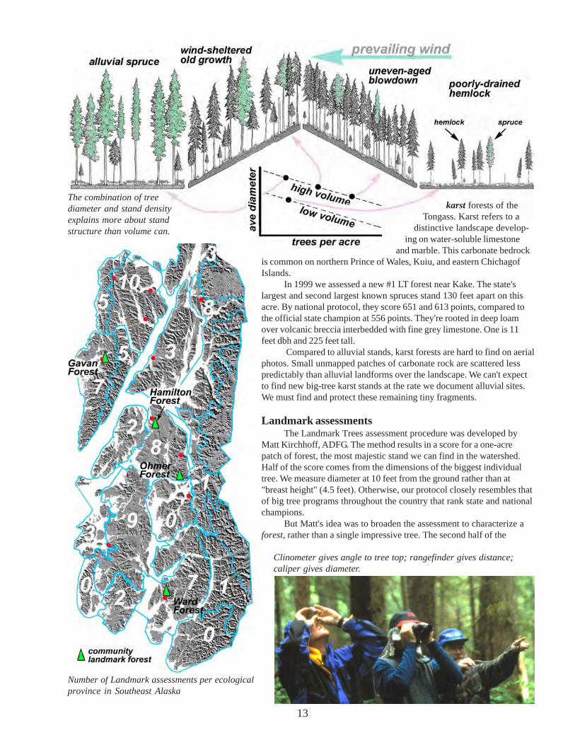
Part II – Giant forests ofSoutheast AlaskaContext - forest types of Southeast
The truly magnificent big tree forests of theTongass cover only a tiny fraction of the landscape.Even on lowland sites, spruce and hemlock fail toachieve their potential growth for one of two basicreasons: either soil is too wet, or some disturbancelike blowdown or logging has set back the succes-sional clock.
Where water table lies close to the surface, treeroots suffocate, resulting in widely spaced smallhemlocks, pines and cedars. These stands have smallaverage diameter and few trees per acre. Standvolume, expressed in thousand board feet per acre(mbf), is low. Trees may be extremely old, however.
On slopes exposed to southerly gales,blowdown stands are prevalent. These young,regenerating forests have small diameters but manytrees per acre. Crowded canopies look smooth-textured from the air. Volume can be surprisingly highin these even-aged forests as they mature beyond100 years. Densely stocked hemlock stands com-monly register more than 50 mbf.
On upland sites that are both reasonably well-drained and wind-protected, uneven-aged old-growth forest eventually develops. Typical locationsare north-facing lee hillsides, but patches of oldgrowth are scattered over most slopes and aspects.Although the largest trees are usually spruce,hemlock is commonly more than 70% of standvolume. Gaps in the old-growth canopy provide lightto the understory, resulting in good winter deerforage. Gross volume is often high, but much of it isunmerchantable due to decay of the many oldhemlocks. The profile on p. 13 suggests there may beas much volume in some mature, well-stockedblowdown forests as in "wind-sheltered old growth."
Most Landmark sites grow not on upland, butbottomland sediments deposited by streams andrivers. This includes floodplain surfaces createdover millennia by the deposits of rivers, and alluvialfans created where streams come off steep slopesonto gentler ones. Forests here have some of thelargest spruces on the Tongass. Large canopy gapspromote luxuriant understory, tending more towarddevil's club and salmonberry than to the blueberryshrubs of upland hemlock-dominated old growth.
Spruce-dominated alluvial stands are not onlyguardians of watershed stability and of wildlifecommunities revolving around salmon; they're alsothe most valuable commercially. Today,"landmarkers" must seek out the few alluvial foreststhat escaped both selective handlogging in the earlytwentieth century, and intensive clearcutting thatbegan in the 1950s.
Even more completely eliminated were the great
13
Number of Landmark assessments per ecologicalprovince in Southeast Alaska
Clinometer gives angle to tree top; rangefinder gives distance;caliper gives diameter.
karst forests of theTongass. Karst refers to a
distinctive landscape develop-ing on water-soluble limestone
and marble. This carbonate bedrockis common on northern Prince of Wales, Kuiu, and eastern ChichagofIslands.
In 1999 we assessed a new #1 LT forest near Kake. The state'slargest and second largest known spruces stand 130 feet apart on thisacre. By national protocol, they score 651 and 613 points, compared tothe official state champion at 556 points. They're rooted in deep loamover volcanic breccia interbedded with fine grey limestone. One is 11feet dbh and 225 feet tall.
Compared to alluvial stands, karst forests are hard to find on aerialphotos. Small unmapped patches of carbonate rock are scattered lesspredictably than alluvial landforms over the landscape. We can't expectto find new big-tree karst stands at the rate we document alluvial sites.We must find and protect these remaining tiny fragments.
Landmark assessmentsThe Landmark Trees assessment procedure was developed by
Matt Kirchhoff, ADFG. The method results in a score for a one-acrepatch of forest, the most majestic stand we can find in the watershed.Half of the score comes from the dimensions of the biggest individualtree. We measure diameter at 10 feet from the ground rather than at"breast height" (4.5 feet). Otherwise, our protocol closely resembles thatof big tree programs throughout the country that rank state and nationalchampions.
But Matt's idea was to broaden the assessment to characterize aforest, rather than a single impressive tree. The second half of the
The combination of treediameter and stand densityexplains more about standstructure than volume can.

14
Measuring diameter at 10 feet above center point, avoidingflare at base.
Landmark Trees score derives from the volume (mbf) of thesurrounding acre. Heights are measured for sample treeschosen by a "variable radius" point sampling method, thenentered into a table to compute volume.
John Caouette, statistician, USFS, has refined theLandmark assessment procedure. We can now compareaverage diameters, heights, standard deviations, etc. to datacollected by the Forest Service in thousands of randomlyselected stands throughout the Tongass.
To evaluate understory we use the Kirchhoff/Hanley
deer winter range quick cruise. This method scores foravailability of key forage shrubs and forbs, and for wintersnow conditions, moderated by such factors as canopyclosure, elevation, aspect, distance from the beach, etc.
Most Landmark Tree forests flunk the deer winterrange test. Understories are usually devil's club/foamflowerrather than blueberry/ground dogwood, and the streamsidebottomlands often collect cold air and a deep, long-lastingsnowpack.
But the streamside community blossoms in summer.The classic riparian Landmark forest is the spruce-salmon-bear-eagle-devil's club-alluvium association (see logo, page2). To score it, we developed a riparian bear habitat assess-ment. A perfect scoring late-summer bear habitat has a heavypink or chum run with shallow fishing riffles, bordered by anopen-canopied alluvial spruce forest over dense thickets offruiting devil's club, salmonberry and stink currant. Unlikethe perfect winter deer forest, the ultimate summer bearforest is more than a mile from the beach, beyond the rangeof most hunters and tourists.
That describes the majority of our Landmark Treeforests. Even in watersheds that were never clearcut,handloggers removed the biggest spruces from the coastalfringes and lower stream reaches. On the larger streams,skilled handloggers could float logs out at flood stage. It'scommon for us to bushwack more than a mile upstreambefore locating a stand worthy of assessment.
About 30% of our Landmark forests were made knownto us through word of mouth. My growing wish list hasabout 100 more sites recommended by outdoorspeoplethroughout Southeast. We found several other stands byperusing the new generation of Forest Service maps thatdelineate "vegetation structure." And we constantly rely onair photos taken by NASA (high elevation, "big picture")and USFS (lower and more detailed). Air photos viewed instereo help not just for finding the biggest forests in awatershed, but for off-trail routefinding and for deepened
Blue bar representing stand score is average of green bar for Big Tree score and brown bar for volume. “Ghost LT” on theleft is a logged karst stand (reconstructed from stump measurements) that scores almost 50% higher than any living LTacre we’ve studied. Next are the top-scoring living Landmark acre, and the top volume–170 mbf–we've encountered on aLandmark site (note however that there were no remarkably large trees on the highest volume acre). Of the 4 CLT forests,Kake's ranks first due to the high volume of its vigorous young spruces. The other CLT forests show disparity betweenimpressive Big Tree scores and relatively low stand volume.

15
Ancient 10.5-foot dbh spruce on karst. Thisone and a close neighbor are the two largestknown trees in Alaska.
familiarity with your favorite places.Visit yourForest Service or Fish and Game air photocollection and ask for a tour!
Remote sites and community sitesDeep into a 2-week solo kayak trip I
stumbled upon an unforgettable forest. Bigchum salmon spurted ahead of me through the6-inch-deep water as I waded upstream. On abar next to enormous spruces were 3 differentsizes of brown bear tracks. I nervously spokealoud the entire time I was measuring; "Nicebedroom you've got here. . . love the ceilings!"Stepping backward, sighting up a plumb bob tomeasure the crown spread of a tree thatcomfortably beat the official state recordspruce, I realized I was standing in freshlyshredded fish. We want people to know aboutthese places. But they're also the forests mostdeserving of anonymity.
An opinionnaire mailed out to folksclosely involved with the Landmark Treesproject asked whether we should publish thewhereabouts of our remote LT forests. Thevote regarding confidentiality was unanimous;leave these off-trail places to the bears! Thatconsensus led us to the idea of creatinginterpretive booklets for big-tree sites wherehigh use already occurs.
The 4 Community Landmark Tree forests (CLTs) are allalluvial, yet quite distinctive. Ketchikan's Ward Creek CLTforest contains the tallest and largest-diameter spruces. Thisforest, though majestic, is but a shadow of the stand thatgrew here before handlogging. In 1900 it might have rankedwith today's highest scoring LT forests.
Near Kake we selected a much younger stand onHamilton Creek. Closely spaced spruces up to 200 feet tallhave relatively small diameters but together yield 50% morevolume than on any other CLT forest.
Succession in LT forestsMany of our Landmark Tree stands are barely mature
enough to be considered "old growth." Such stands are
often 90% spruce by volume. Trees reach 200 feet, with full,undamaged tops, yet rarely exceed 5 feet in diameter at 10feet up. Large canopy gaps foster nearly complete cover ofdevil's club/salmonberry thickets. Some gravel/cobblesurfaces are flooded annually.
In "middle age," a third of the volume may be hemlock.Tree height and stand volume peak. On our finest alluvial LTforests, volume reaches a plateau in middle age at about 140mbf. Largest diameters are about 7 feet across at 10 feet up.Blueberry joins devil's club in the understory, whereflooding now occurs less than once per century.
We've only assessed 2 extremely old alluvial sites.Stream incision here has left the floodplain inactive formillennia. Hemlock is ~70% of stand volume, but enormousold spruces persist. By the time an Alaskan spruce reaches 8
Three stages in succession ofLandmark forests. To reach LT
status probably takes at least 200years, so the term “youth” is
relative. Only after millennia doLandmark stands show signs of
senescence.

16
feet diameter at 10 feet up (~10 ft dbh), its top is usuallybroken. Deeply furrowed bark suggests an age approaching1000 years, but increment borers can't reach the pith of suchtrees.
What’s left?To map the Tongass big-tree forest–as it once looked
and as it looks today–we need more information than justvolume. The highest volume that landmarkers have mea-sured–170 mbf–was not in a big tree forest but in a denselystocked stand of tall, medium-diameter trees! Most forestecologists now feel that attributes like trees-per-acre, meantree diameter (or its standard deviation), soil moisture, slope,wind exposure, canopy texture and understory structure, aremore useful than volume in describing forest habitat.
The Forest Service has prepared these "vegetationstructure maps" for the entire Tongass. One mappedcategory shows forests of large spruces with coarse canopyon gentle alluvial slopes. On Mitkof Island, for example, this“big-tree forest” is now reduced to about one half of onepercent of the landscape. The part of that which is truly ofLandmark caliber may be as little as 1 or 2%. We have yet tofind a superlative one-acre patch on Mitkof. The MitkofLandmark forest constitutes roughly one acre in 10,000.
Mitkof never did have extensive alluvial big treeforests. But on Chichagof and northern Baranof islands
Trocadero Bay, Prince of Wales Island, 1979 This color infrared air photo shows a typical logging intensity in fairlylow-productive watersheds. (Productive lands are usually cut more heavily.) Trocadero’s gentle hills still have unloggedscrubby forest. Originally the fan/floodplain big-tree forest occupied 7% of this scene. The 100-acre patch of remnant bigspruce at center now comprises 1.3%. Of that, only 1 or 2 acres are of outstanding Landmark caliber.
such forests wereonce widespread.There, recent GIS(geographic informa-tion system) analysisindicates that in most"timber priority"watersheds, 60 to 90%of the alluvialbottomland has beenlogged. This figureunderrepresents totalloss, because theremaining streamsideforest is inferior inquality to the loggedstands.
Sacrifice of thegreat riparian forest issobering, but loss ofour karst forest isstaggering. Today'stop 5 Landmarkforests would nothave made the top1000 in 1950, before Handloggers on Long Island.

17
industrial scale logging began. After measuring acreagesfrom pre-logging photographs, I concluded that thelowland karst of northern Long Island alone held nearlyas much Landmark-caliber forest in the 1970s aspresently remains in all of Southeast Alaska.
The “core community”Exciting interdisciplinary research is uncover-
ing relationships between salmon and salmonber-ries, upwellings and nutrient pulses, nitrogen andriparian birds, that few suspected a decade ago.For those of us who've been splashing upstreams in search of big trees, these findingsreinforce a growing belief that the ripariancommunity of spruce, salmon, bear, eagle anddevil's club is the foundation of our bioregion'sfertility. Birds, mammals, and fish from everysurrounding terrestrial and marine communitymigrate here annually to partake of the stream'sbounty.
One branch of the research employs isotopicmarkers to identify marine-derived nutrientsreturned to the land by spawning salmon. Thesenutrients end up not only in terrestrial salmonpredators and scavengers, but in riparian vegeta-tion like devil’s club and stink currant many yardsfrom the stream. On some streams bears carry halfof the spawners to shore, where the fish eitherdecompose or return to the soil as bear scat,providing nitrogen, phosphorus, carbon andmicronutrients.
Everything eats salmon, directly or indirectly. Evensongbird populations are denser on streams with salmon
runs; is this because fertilized shrubs and herbs supportmore bird-feeding insects? Juvenile salmon them-
selves also benefit indirectly from the disintegratingbodies of their parents, since they eat aquaticinvertebrates that feed in turn on the mat of algae,fungi and bacteria covering fish carcasses.
Another branch of research still in itsinfancy is probing the hyporheic zone, thesaturated sediment beneath and beside streamsand rivers where ground and surface water meet.The rich but scarcely documented microfauna ofthe hyporheic zone often dominate the biologicalproductivity of rivers. Beneath broad floodplainsthe volume of hyporheic habitat may be 2000times greater than actual channel volume, yet werarely consider the implications. Hyporheicupwellings supply alder- and salmon-derivednutrients to side-slough algal colonies and tosoils far from the channel, storing and spreadingthese growth-enhancers throughout the alluvium.
Each closer look astonishes. Among gianttrees and brown bears, we may neglect to lookdown–to run our fingers through the moss–andwonder why such a community has floweredbeside the stream.
stink currant

18
Appendix - maps, charts and stereograms for Ohmer Forest
Ohmer Forest todayProfile looking north across the east tributaryof Ohmer Creek. As in most old-growthforests, spruces are taller on average thanhemlocks. Trees were replaced on the cutstumps (brown) to create the view below. Toestimate their former height, I used height-to-diameter ratios from assessments of livingforests at Ohmer Forest’s latitude.
Ohmer Forest in 1900ADOhmer before handlogging. To produce thisview I not only had to estimate the formerheights of cut trees, but also needed to reducethe heights of surviving trees in the aboveview by 30%. This accounted for the 90 yearsof post-logging “release” after the canopywas opened by logging.
Stand Visualization System (SVS)images, July 2000 surveyInto the SVS program we enter tree heights,diameters, crown depth and X-Y position tocreate computer-generated views from anyangle (vertical, profile, or oblique) ofmapped forest stands–in this case a one-acre square. Using stump diameters andassumptions about tree height, we can alsocompare the historical condition atOhmer Forest in 1900 AD.
Oblique view northSpruces are dark green; hemlocks paleryellow-green. Profile views below show thisstand from the south, today as compared to acentury ago.

19
Stereograms are paired aerial photos taken from slightly different angles to produce a 3D image when printed outand viewed with a stereoscope. Few readers have stereoscopes, but I've included stereograms anyway because theyreveal so much more than you can see on even the sharpest 2D photos. Ask any forester or geologist for a stereoscopelesson; you may find yourself ordering one of these invaluable tools.
Even without a stereoscope you can see stereograms in 3D. Try "free viewing." Hold the photo-pair a foot ortwo away. Look over the top, focusing on a distant object. Then drift your eyes down onto the paired photos, and tryto make the double images converge. It's much like the trick your eyes perform when viewing "3D Magic" books.
Stereogram of OhmerForest, USFS, 4/27/98. Onthis low-elevation imagery,spruce crowns look likewheel spokes
Stereogram of Ohmer Creek,USFS, 1989. Note that, incontrast to the above pair,north is to the left on theseimages. Viewed 3D, thisphoto-pair clearly showshow larger trees follow thebetter-drained streamsidedeposits. Ohmer Forest isjust a remnant; even biggerspruces were removed fromthe upstream clearcut atupper left. The stereogramon page 20 gives a broaderview of the watershed.
Note that north arrowsdiffer on the 3 stereogramsin this guide. Stereogrambearing is constrained bythe plane’s flight direction.

20
Logging on Mitkof Island has targeted high-volume even-aged forests on south-facing, wind-exposed slopes. This patternhas differed from most clearcut logging on the Tongass from 1950 to the late 1970s, which instead focused on alluvialbottomlands and karst. Although Mitkof had (and to some degree retains) extensive high-volume windthrow forests, thealluvial big-tree forest is poorly represented on this island. Ohmer Forest is a valuable example of a rare type.
Stereogram of lowerOhmer Creek, NASA,1996. Arrow showsOhmer Forest in center atconfluence of East andNorth forks. Blue-tintedopenings in lowlands aresphagnum bog. Clearcutsrange from pale grey(recent) to pink-orange(older). Ohmer estuary isat center right, BlindRiver at lower left. Bigtree forest is restricted tostreamsides, only afraction of one percent ofthis scene.

21
alluvium - Well-drained deposits of streams and rivers - typicalsubstrate for the big-tree forest.alluvial fan - Deposit of alluvium at base of steep slope.big-tree forest - A stand with average diameter (dbh) greater than21inches (compare “volume” below).blowdown forest - Even-aged stand recovering from windstormthat toppled the previous forest.capture - When a community resists transition to a more “ad-vanced” successional stage: e.g. alder capture delaying the succes-sion to spruce/hemlock forest.crown depth - Proportion of tree height occupied by living foliage.dbh - Tree diameter at breast height, or 4.5 feet above ground.evergreen forbs - Low-growing plants that stay green all winter,critical deer forage.epicormic branching - fresh branches from trunk of a spruce treerecently exposed to more light.floodplain - Level alluvial deposits along streams and rivers.hyporheic zone - Saturated sediment beneath and beside streamsand rivers where ground and surface water meet.increment core - Wood sample taken from tree with incrementborer, for examination of annual rings.karst - The topography developing on soluble carbonate rocks -limestone and marble. Karst once supported the greatest big-treeforests of Alaska.landmark-tree forest - The best of the big-tree forest - the creamof the cream.mbf - Thousands of board feet per acre (see “volume” below).More than 50 mbf is considered very high volumemistletoe, a parasitic seed-bearing plant whose roots penetrate thebark of hemlock, slowing the tree’s growth,nurse log - Dead log on the ground that provides a rooting surfacefor hemlock or spruce seedlings.open-grown - A conifer that grows in the open without competi-tion for light, characterized by large branches (or later, their stubs)almost down to ground level.pitch-outs - Spruce defends itself from bark beetles by expellingpitch through the entry holes.productivity - In forest habitats, usually expressed as net rate ofgrowth per unit time. Foresters also refer to “site index” or theaverage height of a 100-year old tree on a given surface type.release - Increased growth rate of a tree following the demise ofneighbors, detectable in increment cores.riparian- The stream- or riverside community that is influencedby flooding, and that contributes litter to the channel.second-growth - Even-aged forest recolonizing after a disturbancesuch as logging or wind throw.
Landmark ScoresOhmer #1 LT Ghost
BT diameter 82” 105” 118”height 175’ 200’ ~220?BT score 137 168 187mbf 61 127 230stand score 99 147 210
These figures help to compare Ohmer Forest to thehighest scoring LT stand in SE Alaska (#1 LT). Thelast column on the right (Ghost) shows ourestimated measurements from a stand on HecetaIsland that was clearcut by handloggers in 1926.
stem map - A forester’s map showing tree trunks, down logs,vegetation, etc.stereogram - Pair of photos taken from slightly different angles toproduce a 3D view when examined with a stereoscope.svs- Stand visualization system. Computer generated view of aforest stand, from measured heights, diameters and (X-Y) groundpositions.volume - measure of the total amount of wood per unit area -usually in thousands of board feet per acre (mbf). Because denselystocked medium-sized trees can have high volume, this term shouldnot be used as synonomous with “big-tree forest.”whorl - Branches emerging from the same level on a young spruce(not hemlock) tree.witches brooms. swollen and proliferating branch clusterscaused by hemlock dwarf mistletoe.wolf tree- Same as “open-grown,” above.
Definitions of some terms used in this guide:
Decade of germination. Ohmer is an “all-aged” ancient forest.Compare with ages for Hamilton Forest, below. Hamilton is afirst-generation forest colonizing uplifted tideland
Diameter and height distributions for Ohmer Landmarkacre. Comparison of heights with Hamilton Forest atKake, a younger and much higher volume forest withmany more big spruces