Embed Size (px)
Citation preview
Friends of Silver Saddle Ranchin partnership with
Carson City, Bureau of Land Management & National Park Service
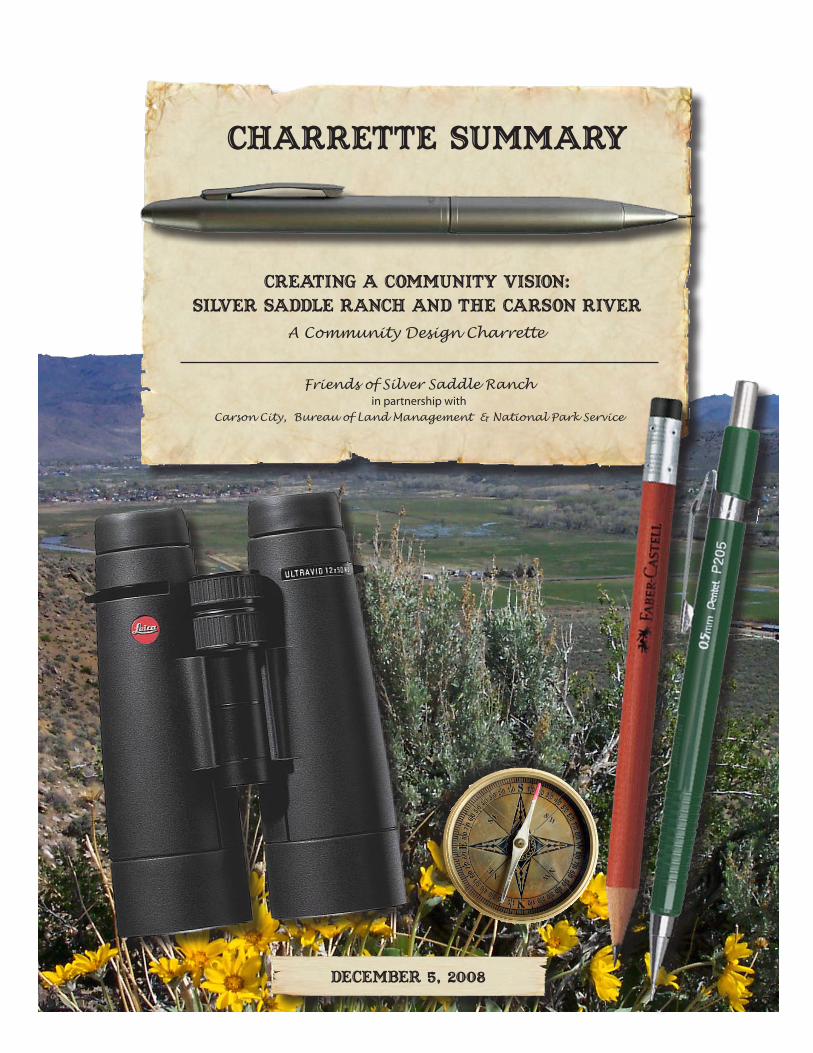
Creating a Community Vision: Silver Saddle Ranch and the Carson River
A Community Design Charrette
charrette summary
Bac
kgro
un
d p
ho
to:
Dan
Jac
qu
et
DECEMBER 5, 2008

Table of Contents
Table of Contents ........................................................................................... i
Acknowledgements ..................................................................................... iii
Executive Summary ...................................................................................... v
Background: Purpose of the Charrette ............................................................ 1 • A Public-Private Partnership .........................................................................1
• Why a Charrette? What is a Charrette? .........................................................2• Orientation to Planning Area ........................................................................3• Planning Framework ................................................................................... 17
Overview of Process .................................................................................... 19• Public Workshops: Setting the Stage ...........................................................21• The Charrette .............................................................................................. 27
Charrette Results ........................................................................................ 31 • Natural Resources Team.............................................................................. 31 • Trails & Passive Recreation Team ................................................................40 • Silver Saddle Ranch & Prison Hill Team ....................................................... 51
• Final Presentation Feedback .......................................................................60
Moving Towards the Future ......................................................................... 63
Appendices A. City Resolutions Supporting the Charrette Process ......................................... A-1B. Silver Saddle Ranch and Carson River Area Planning Framework .................... B-1C. Self Guided Tour Brochure............................................................................... C-1D. Charrette Informational Brochures ................................................................. D-1E. 4/24/08 Public Workshop Summary ................................................................. E-1F. 5/8/08 Public Workshop Summary ....................................................................F-1G. Charrette Teams ............................................................................................. G-1H. Field Trip Observations .................................................................................... H-1I. Natural Resources Team Original Notes and Drawings ......................................I-1J. Trails & Passive Recreation Team Original Notes and Drawings ........................ J-1K. Financial and Marketing Concepts ................................................................... K-1L. Silver Saddle Ranch & Prison Hill Team Original Notes and Drawings ...............L-1M. Public Feedback on Charrette Results ............................................................ M-1
(c) N
ancy
San
tos
iTable of Contents

ii Creating a Community Vision: Silver Saddle Ranch & the Carson River

Acknowledgements
The Friends of Silver Saddle Ranch would like to acknowledge and thank the following groups and individuals for their contributions to this community-wide planning effort.
Planning TeamNancy Santos, Friends of Silver Saddle Ranch
Dan Jacquet, Bureau of Land ManagementJuan Guzman, Carson City Parks and Recreation Department
Anne Dove, National Park Service-Rivers, Trails, and Conservation Assistance Program
Friends of Silver Saddle RanchMichael BishLarry French
Kathryn Keever
Bureau of Land ManagementElayn BriggsArthur CallanBryant Smith
Carson CityOfficials
Shelly Aldean, Board of SupervisorsRobin Williamson, Board of Supervisors
Donna Curtis, Carson City Parks and Recreation CommissionMark Kimbrough, Planning Commission
Dan Greytak, Carson River Advisory CommitteeTricia Lincoln, Open Space Advisory Committee
Wayne Perock, Open Space Advisory CommitteeHoward Riedl, Open Space Advisory Committee
StaffRoger Mollendorf, Parks and Recreation Department
Vern Krahn, Parks and Recreation DepartmentAnne Bolinger, Parks and Recreation Department
Janice McIntosh, Carson City Community Senior CenterLee Plemel, Development Services-Planning Division
iiiAcknowledgements
National Park Service-Rivers, Trails and Conservation ProgramPeg Henderson
Deb Reardon
Additional Charrette Participants Valerie Andersen, Sierra Club Great Basin Group
Genie Azad, Carson River CoalitionRon Blakemore, Blakemore Landscape Architects
Don Boebel, Disc GolfMargie Evans, UNCE Weed Coalition
Chris Freeman, State Conservation CommissionPat Fried, Western Nevada Resources, Conservation & Development
Jim Gaither, The Nature ConservancyLarry Gorell, Neighboring resident
Lyndy Holton-Larson, Design WorkshopDan Kaffer, Natural Resources Conservation Service
Karen Kish, Lahontan Audubon SocietyDan Kovach, CFA Inc.
Micah Langdon, Design WorkshopTina Nappe, Sierra Club
Erich Obermayr, MACTEC Engineering and ConsultingTed Petersen, Jeff Codega Planning & Design
Duane Petite, The Nature ConservancyRobin Powell, Audubon-Nevada Important Bird Area Program
Kevin Roukey, US Army Corps of EngineersColeen Shade, Design Workshop
Rich Shock, Jeff Codega Planning & DesignJeremy Vlcan, Carson Valley Trails/Beneficial DesignsSandra Wallin, Univeristy of Nevada Reno Extension
Rich Wontorski, Western Equestrian AllianceSteve Woodbury, Nevada Commission on Tourism
Lastly, thank you to the members of the public who participated in the workshops and forums leading up to and following the charrette for their interest and thoughtful input.
iv Creating a Community Vision: Silver Saddle Ranch & the Carson River
Executive Summary
Creating a Community Vision: Silver Saddle Ranch and the Carson River project began as an effort by the Friends of Silver Saddle Ranch to encourage community interest and participation in the development of a management plan for Silver Saddle Ranch. The 703-acre Silver Saddle Ranch is public (federal) land cur-rently managed by the Bureau of Land Management.
The City of Carson City became interested in obtaining ownership of Silver Saddle Ranch, as a potential new park for Carson City in 2006, following the development of the Carson City Federal Lands Bill. In 2007, Silver Saddle Ranch and the adjacent Bureau of Land Management Prison Hill Recreation Area were included in the Carson City Lands Bill as Addendum A.
The Friends of Silver Saddle Ranch received an assistance grant from the National Park Service, Rivers Trails and Conservation Assistance Program in 2006. The grant was to be used to develop a management plan for Silver Saddle Ranch through a community involvement process. The planning team included a representative from each primary stakeholder including the Friends of Silver Saddle Ranch, Bureau of Land Management, and Carson City, with assistance from the National Park Service.
Once the planning team was developed and the kick-off meeting held it was agreed upon immediately that the planning area should include all public lands along the Carson River within Carson City. A char-rette (planning and design) process was then developed for an area approximately 3,000 acres.
The planning process included three public workshops for which community members were encouraged to attend and provide input on what they would like to see in the planning area. The final 2-day workshop focused on incorporating the community ideas into a comprehensive plan that considers all the sites and the Carson River as one large planning area. Participants in attendance included individuals from numer-ous stakeholder groups including federal, state and local agencies; neighboring residents, environmental and recreational groups, and natural resource specialists.
Topics of importance determined for review and discussion as part of the Silver Saddle Ranch and the Carson River planning process included Natural Resources, Trails & Passive Recreation, and Silver Saddle Ranch & Prison Hill. Financial and Marketing Concepts were also considered.
The details and results of this community planning process are summarized in this report. This planning and design process and the Summary Report are intended as a guide to the future development of the Sil-ver Saddle Ranch and Carson River Area, based on the desires of Carson City community members. Steps for Moving Towards the Future are identified in the final section of the report.
vExecutive Summary

8 Creating a Community Vision: Silver Saddle Ranch & the Carson River
1Background: Purpose of the Charrette
Background: Purpose of the Charrette
At the eastern edge of Eagle Valley in Carson City, Nevada, lies a unique series of sites linked by the Carson River. Over time, several areas along the river have been purchased and set aside for open space, conservation and recreation for the com-munity and visitors alike. From the southern area of Carson City near Golden Eagle Road north toward Morgan Mill Road is a network of open spaces including Silver Saddle Ranch (SSR), Prison Hill Recreation Area and several sites recently acquired by Carson City and the Bureau of Land Management (BLM). The result is a unique opportunity to envision the future for this contiguous series of open spaces together as a contiguous area.
A Public-Private PartnershipThe Friends of Silver Saddle Ranch (FOSSR), in partnership with Carson City, the Bureau of Land Management (BLM) and with support from the National Park Ser-vice Rivers, Trails and Conservation Assistance Program (NPS) conducted a public process to define a community-wide vision for the planning area. Through a series of public workshops and an intensive 3-day “charrette” during spring of 2008, a com-munity-based vision for the area was developed along with ideas for implementing it. The charrette was named: “Creating a Community Vision: Silver Saddle Ranch and the Carson River”.
BLM, Carson City and FOSSR had been working together to develop a draft Cooperative Management Agreement (CMA) to jointly manage Silver Saddle Ranch, a BLM facility located in Carson City. The purposes of the CMA were to improve management of the area, protect and enhance the natural and cultural resources, and provide greater recreational and environmental education opportunities for the community to enjoy their public lands. As the CMA was being drafted, FOSSR submitted an application for technical assistance from the NPS to facilitate a community-based process to develop design and planning recommendations for Silver Saddle Ranch based on the existing BLM “Interdisciplinary Management Plan for the Silver Saddle Ranch and the Ambrose Carson River Natural Area” (2000). In September 2006, assistance for this planning effort was awarded to FOSSR.
In fall 2006, Carson City initiated consultations with US Senator Harry Reid’s office to draft a federal lands bill that would result in transfer of some BLM and US Forest Service lands to Carson City and vice versa. Given this new effort, the scope of the community-based process for Silver Saddle Ranch was expanded to include public lands to the north and south of Silver Saddle Ranch along the Carson River Corridor in anticipation that these contiguous areas could eventually be managed primarily by the City. The result was a larger, redefined planning area that was described as
2 Creating a Community Vision: Silver Saddle Ranch & the Carson River
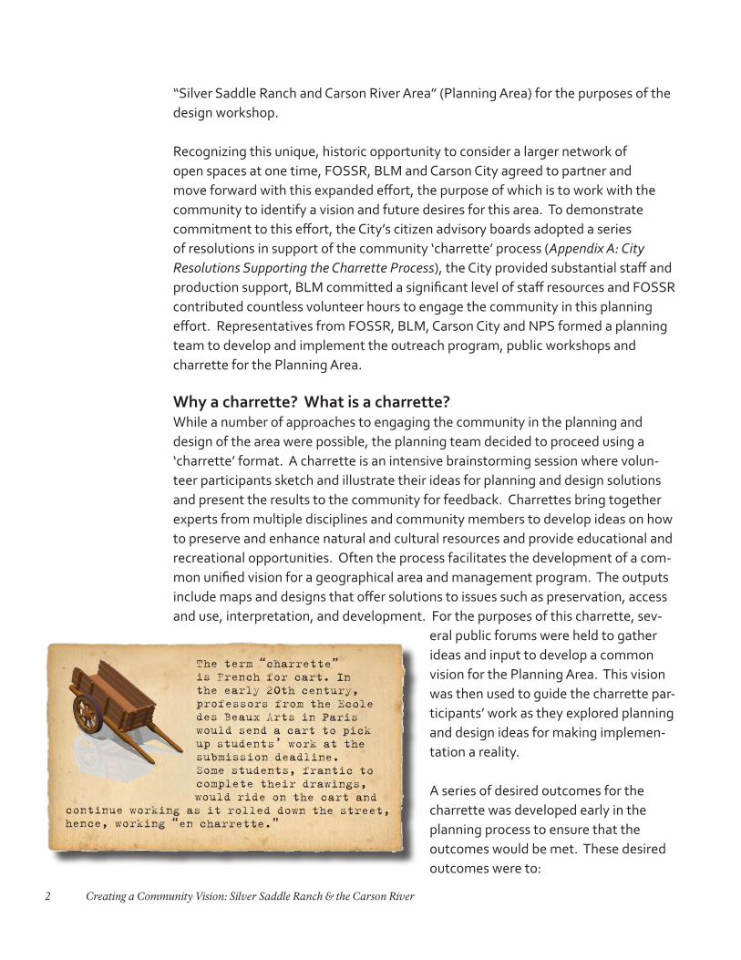
The term “charrette” is French for cart. In the early 20th century, professors from the Ecole des Beaux Arts in Paris would send a cart to pick up students’ work at the submission deadline. Some students, frantic to complete their drawings, would ride on the cart and
continue working as it rolled down the street, hence, working “en charrette.”
“Silver Saddle Ranch and Carson River Area” (Planning Area) for the purposes of the design workshop.
Recognizing this unique, historic opportunity to consider a larger network of open spaces at one time, FOSSR, BLM and Carson City agreed to partner and move forward with this expanded effort, the purpose of which is to work with the community to identify a vision and future desires for this area. To demonstrate commitment to this effort, the City’s citizen advisory boards adopted a series of resolutions in support of the community ‘charrette’ process (Appendix A: City Resolutions Supporting the Charrette Process), the City provided substantial staff and production support, BLM committed a significant level of staff resources and FOSSR contributed countless volunteer hours to engage the community in this planning effort. Representatives from FOSSR, BLM, Carson City and NPS formed a planning team to develop and implement the outreach program, public workshops and charrette for the Planning Area.
Why a charrette? What is a charrette?While a number of approaches to engaging the community in the planning and design of the area were possible, the planning team decided to proceed using a ‘charrette’ format. A charrette is an intensive brainstorming session where volun-teer participants sketch and illustrate their ideas for planning and design solutions and present the results to the community for feedback. Charrettes bring together experts from multiple disciplines and community members to develop ideas on how to preserve and enhance natural and cultural resources and provide educational and recreational opportunities. Often the process facilitates the development of a com-mon unified vision for a geographical area and management program. The outputs include maps and designs that offer solutions to issues such as preservation, access and use, interpretation, and development. For the purposes of this charrette, sev-
eral public forums were held to gather ideas and input to develop a common vision for the Planning Area. This vision was then used to guide the charrette par-ticipants’ work as they explored planning and design ideas for making implemen-tation a reality.
A series of desired outcomes for the charrette was developed early in the planning process to ensure that the outcomes would be met. These desired outcomes were to:
3Background: Purpose of the Charrette
• Define a community-wide vision for the Silver Saddle Ranch and Carson River area• Develop an integrated management plan• Foster partnerships• Build support and capacity for community-based
stewardship• Develop a vision for how to sustain the Carson
River ecosystem over the long-term• Identify sustainable management practices, in-
cluding financial and implementation strategies
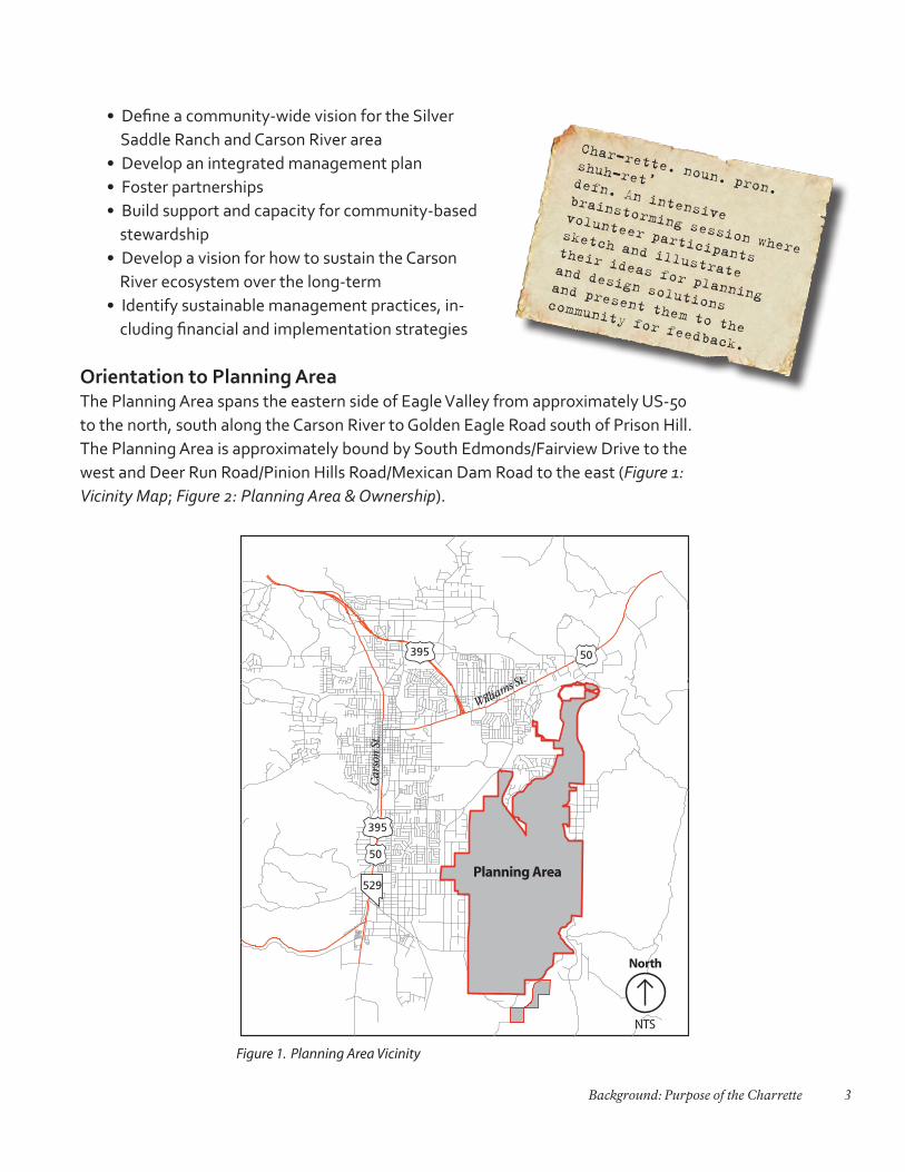
Orientation to Planning AreaThe Planning Area spans the eastern side of Eagle Valley from approximately US-50 to the north, south along the Carson River to Golden Eagle Road south of Prison Hill. The Planning Area is approximately bound by South Edmonds/Fairview Drive to the west and Deer Run Road/Pinion Hills Road/Mexican Dam Road to the east (Figure 1: Vicinity Map; Figure 2: Planning Area & Ownership).
Char-rette. noun. pron.
shuh-ret’defn. An intensive brainstorming session where
volunteer participants
sketch and illustrate
their ideas for planning
and design solutions and present them to the
community for feedback.
Figure 1. Planning Area Vicinity
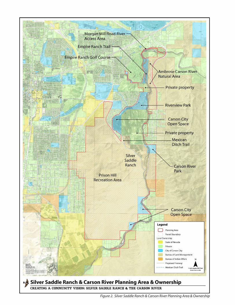
Figure 2. Silver Saddle Ranch & Carson River Planning Area & Ownership
5Background: Purpose of the Charrette
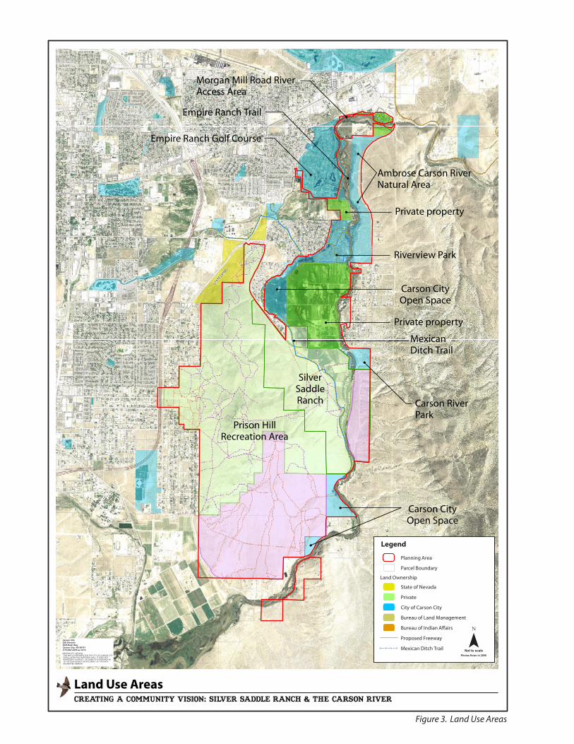
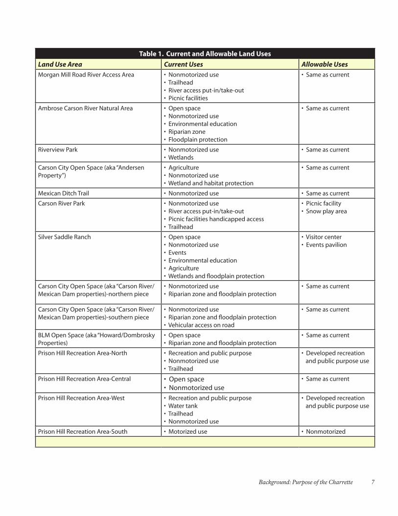
Existing Open Spaces and ParksWithin the planning area is a series of publically-owned sites that range from city-owned parks and open space to BLM open spaces and natural areas. Several privately owned sites adjoin the Planning Area. Throughout the planning process, Carson City and BLM continued to aquire sites in the Planning Area, closing ‘gaps’ in public ownership. With the exception of these newly-acquired open properties, each publically-owned site in the planning area has separate guiding documents that describe the permitted uses allowed in each site (Figure 3: Land Use Areas; Table 1: Current and Allowable Uses). At this point, while several relevant overlapping plans and jurisdictions exist, no one plan guides the future of the entire planning area. The following are descriptions of the specific sites within the Planning Area from north to south.
XWXWXWXWXWXWXWXWXW
XWXWXWXWXWXWXWXW
XW XW XW XW XW XW XW XW XW XW XW XW XW XW XW XW XW XW XW XW
XWXWXWXWXW
XWXWXWXWXWXWXWXWXW
XWXWXWXWXWXW
XWXWXWXWXWXWXWXWXW
XWXWXWXWXWXWXWXWXWXWXW
XW XW
XWXWXWXWXWXWXWXWXWXWXWXWXWXWXWXWXWXWXWXW
XWXWXWXWXW
XWXWXWXWXWXWXWXWXW
XWXWXWXWXW
XWXWXWXW
XWXWXWXW XW XW XW XW XW XW XWXW
XWXWXWXWXW
XWXWXWXWXWXWXWXWXWXWXW XW XW XW
XWXW XW XW XW XWXW XW XW XW XW XW XW XWXWXWXWXWXWXWXW XW XW XW XW XW XW XW XW XW XW XW XW XW XW XW XW
XWXWXWXW
XWXWXWXWXWXWXWXWXWXWXWXWXWXWXW
XW
XW XW XW XW XW XW XW XW XW XWXW XW XW
XW
XWXWXW
XWXWXWXWXW XW XW XWXW
XWXWXWXW
XWXW
XWXWXWXWXW XW XWXW
XWXWXWXWXWXWXW
XW XW XW XW XW XW
XWXWXWXW XW XW XW XW XW XW XW XW XW XW XW XW XW XW XW XW XW XW
XWXWXWXWXWXWXWXWXWXWXWXWXWXWXWXWXWXWXWXWXWXWXWXWXWXWXWXWXWXWXWXWXWXW
XWXWXWXWXWXWXWXWXWXWXWXW
XWXWXWXWXWXWXWXW
XWXWXWXW
XWXWXWXW
XWXW XW XW XW XWXW
XWXW
XWXW XW XW XW XWXW
XWXW
XWXW XW XW XW XWXW
XW
XW XW XWXW XW XW XWXWXW XW XWXWXWXW XW XW
XW XW XW XW XW XWXW
XWXWXW
XWXW
XWXW XWXW XWXW
XWXWXWXWXWXWXWXWXWXWXWXWXWXWXWXWXWXWXWXWXW
XWXWXWXW
XWXWXWXWXWXWXW
XWXWXWXW
XWXWXWXWXWXWXWXWXWXWXWXWXWXWXWXW
XWXWXWXW
XWXWXWXWXWXWXWXWXWXWXWXWXWXWXWXWXWXW XWXW
XWXW XW XW XW XW XWXWXWXWXWXW
XWXWXWXW
XWXW
XWXWXWXWXWXWXWXWXWXWXWXWXWXWXWXWXWXWXWXWXWXWXW XW XW XW XW XW XW XW XW XW XW XW XW XWXWXW
XWXWXWXWXW XW XW XWXWXW
XWXW XWXWXWXWXWXWXWXWXWXWXWXWXWXWXWXWXWXWXWXWXWXWXWXWXWXWXWXW XW XWXW
XWXWXW
XWXWXW
XWXWXWXWXWXWXWXWXWXWXWXWXWXWXWXWXWXWXWXWXWXWXWXWXWXWXWXWXWXWXWXWXWXWXWXWXWXWXWXWXW
XWXWXWXWXWXW
XWXW
STATE
LANDS
HWY 50 E
E 5TH ST
SB395
NB
395
FARI
VEI
WD
RYP EGELL
OC
NRO
OP
ST
SCA
RSO
NST
SNYDER AV
E LONG ST
SRO
OP
ST
NCA
RSO
NST
ND
EER
R UN
R D
CARSONRIVER
RD
NLO
MPA
L N
COLORADO ST
AIR
PORT
RD
SC U
R RY
S T
ARROWHEAD DR
SD
EER
RUN
R D
NORTHRIDGE DR
SSA
LIM
AN
R D
E WILLIAM ST
NSA
LIM
AN
RD
SST
EWA
RTST
CARMINE ST
HOTSP
RINGS
RD
NST
EWA
RTST
KOONTZ LN
RUSS
E LL
WY
GON
IRD
PIN
ION
HIL
LSD
R
W NYE LN
E MUSSER ST
NSU
NRI
DG E
DR
CLEARVIEW DR
E NYE LN
SILV
ERSA
GED
R
E WINNIE LN
LITTLE LN
EAGLE STATION LN
E WASHINGTON ST
W 5TH ST
W LONG ST
SD
IVIS
I ON
S T
W WINNIE LN
JUNI
RETA
ILDR
RHODES ST
W WASHIN TG ON ST
SILV
ERSA
GED
R
¯Not to scale
Photos flown in 2006
! ! ! !
creating a community vision: silver Saddle Ranch & The Carson River
Carson CityGIS Division3505 Butti WayCarson City, NV 89701(775) 887-2355 ex.1013CARSON CITY, NEVADA THIS MAP IS PREPARED FOR THE CITY OF CARSON CITY FOR ILLUSTRATIVE PURPOSES ONLY, IT DOES NOT REPRESENT A SURVEY. NO LIABILITY IS ASSUMED AS TO THE SUFFICIENCY OR ACCURACY OF THE DATA DELINEATED HEREON.
Figure 3. Land Use Areas
7Background: Purpose of the Charrette
Table 1. Current and Allowable Land Uses
Land Use Area Current Uses Allowable Uses
Morgan Mill Road River Access Area • Nonmotorized use• Trailhead• River access put-in/take-out• Picnic facilities
• Same as current
Ambrose Carson River Natural Area • Open space• Nonmotorized use• Environmental education• Riparian zone• Floodplain protection
• Same as current
Riverview Park • Nonmotorized use• Wetlands
• Same as current
Carson City Open Space (aka “Andersen Property”)
• Agriculture• Nonmotorized use• Wetland and habitat protection
• Same as current
Mexican Ditch Trail • Nonmotorized use • Same as current
Carson River Park • Nonmotorized use• River access put-in/take-out• Picnic facilities handicapped access• Trailhead
• Picnic facility• Snow play area
Silver Saddle Ranch • Open space• Nonmotorized use• Events• Environmental education• Agriculture• Wetlands and floodplain protection
• Visitor center• Events pavilion
Carson City Open Space (aka “Carson River/Mexican Dam properties)-northern piece
• Nonmotorized use• Riparian zone and floodplain protection
• Same as current
Carson City Open Space (aka “Carson River/Mexican Dam properties)-southern piece
• Nonmotorized use• Riparian zone and floodplain protection• Vehicular access on road
• Same as current
BLM Open Space (aka “Howard/Dombrosky Properties)
• Open space• Riparian zone and floodplain protection
• Same as current
Prison Hill Recreation Area-North • Recreation and public purpose• Nonmotorized use• Trailhead
• Developed recreation and public purpose use
Prison Hill Recreation Area-Central • Open space• Nonmotorized use
• Same as current
Prison Hill Recreation Area-West • Recreation and public purpose• Water tank• Trailhead• Nonmotorized use
• Developed recreation and public purpose use
Prison Hill Recreation Area-South • Motorized use • Nonmotorized
8 Creating a Community Vision: Silver Saddle Ranch & the Carson River
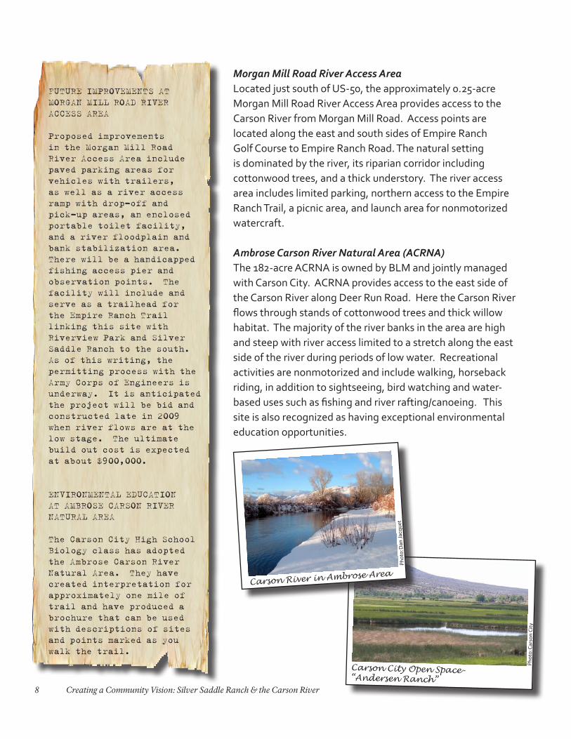
Morgan Mill Road River Access AreaLocated just south of US-50, the approximately 0.25-acre Morgan Mill Road River Access Area provides access to the Carson River from Morgan Mill Road. Access points are located along the east and south sides of Empire Ranch Golf Course to Empire Ranch Road. The natural setting is dominated by the river, its riparian corridor including cottonwood trees, and a thick understory. The river access area includes limited parking, northern access to the Empire Ranch Trail, a picnic area, and launch area for nonmotorized watercraft.
Ambrose Carson River Natural Area (ACRNA)The 182-acre ACRNA is owned by BLM and jointly managed with Carson City. ACRNA provides access to the east side of the Carson River along Deer Run Road. Here the Carson River flows through stands of cottonwood trees and thick willow habitat. The majority of the river banks in the area are high and steep with river access limited to a stretch along the east side of the river during periods of low water. Recreational activities are nonmotorized and include walking, horseback riding, in addition to sightseeing, bird watching and water-based uses such as fishing and river rafting/canoeing. This site is also recognized as having exceptional environmental education opportunities.
FUTURE IMPROVEMENTS AT MORGAN MILL ROAD RIVER ACCESS AREA
Proposed improvements in the Morgan Mill Road River Access Area include paved parking areas for vehicles with trailers, as well as a river access ramp with drop-off and pick-up areas, an enclosed portable toilet facility, and a river floodplain and bank stabilization area. There will be a handicapped fishing access pier and observation points. The facility will include and serve as a trailhead for the Empire Ranch Trail linking this site with Riverview Park and Silver Saddle Ranch to the south. As of this writing, the permitting process with the Army Corps of Engineers is underway. It is anticipated the project will be bid and constructed late in 2009 when river flows are at the low stage. The ultimate build out cost is expected at about $900,000.
ENVIRONMENTAL EDUCATION AT AMBROSE CARSON RIVER NATURAL AREA
The Carson City High School Biology class has adopted the Ambrose Carson River Natural Area. They have created interpretation for approximately one mile of trail and have produced a brochure that can be used with descriptions of sites and points marked as you walk the trail.
Pho
to: C
arso
n C
ity
Carson City Open Space-“Andersen Ranch”
Pho
to: D
an J
acq
uet
Carson River in Ambrose Area

9Background: Purpose of the Charrette
Riverview ParkConsisting of 109 acres of natural area, Riverview Park is contiguous with the Korean War Veterans Memorial Park. The main entrance to Riverview Park is located at the east terminus of E. Fifth Street, with a trail from the nearby residential area connecting from northwest corner. The park is bordered on the east by the Carson River. A variety of habitats is located here, including upland sagebrush, wetlands, cottonwood trees and an understory along the river banks. Riverview Park includes trailheads, a 1.6-mile exercise course and a 0.4-mile nature trail. Additional amenities include abundant paved parking, vault restrooms, barbeques, and uncovered picnic areas. Within the Planning Area, this is one of the most heavily used sites.
Carson City Open Space (informally known as “Andersen Ranch” area)In July 2008, Carson City announced that it would purchase the 86-acre Andersen Ranch property located just east of Carson River Road and Buzzy’s Ranch Road. This site primarily consists of wetlands and wet meadows. The property will help connect Riverview Park with Silver Saddle Ranch to the south. The Mexican Ditch Trail runs along the west side of the property. The 397-acre private property known as Jarrard Ranch is located to the east of the Andersen Ranch and is also a target for acquisition by the City for open space.
Mexican Ditch Trail CorridorThe approximately 3.5-mile, unpaved Mexican Ditch Trail parallels the Mexican Ditch from the Moffat Open Space site to the north, through Silver Saddle Ranch, and ending at Mexican Dam to the south. The Mexican Ditch was historically used to run the Mexican Mill in the 1860’s and later used to provide agricultural irrigation. The ditch is still in operation today and contains enough water throughout the year to maintain willows along both sides. Trail uses include pedestrian, equestrian and cycling activities.
Pho
to: A
nn
e D
ove
Mexican Ditch & Mexican Ditch Trail
10 Creating a Community Vision: Silver Saddle Ranch & the Carson River
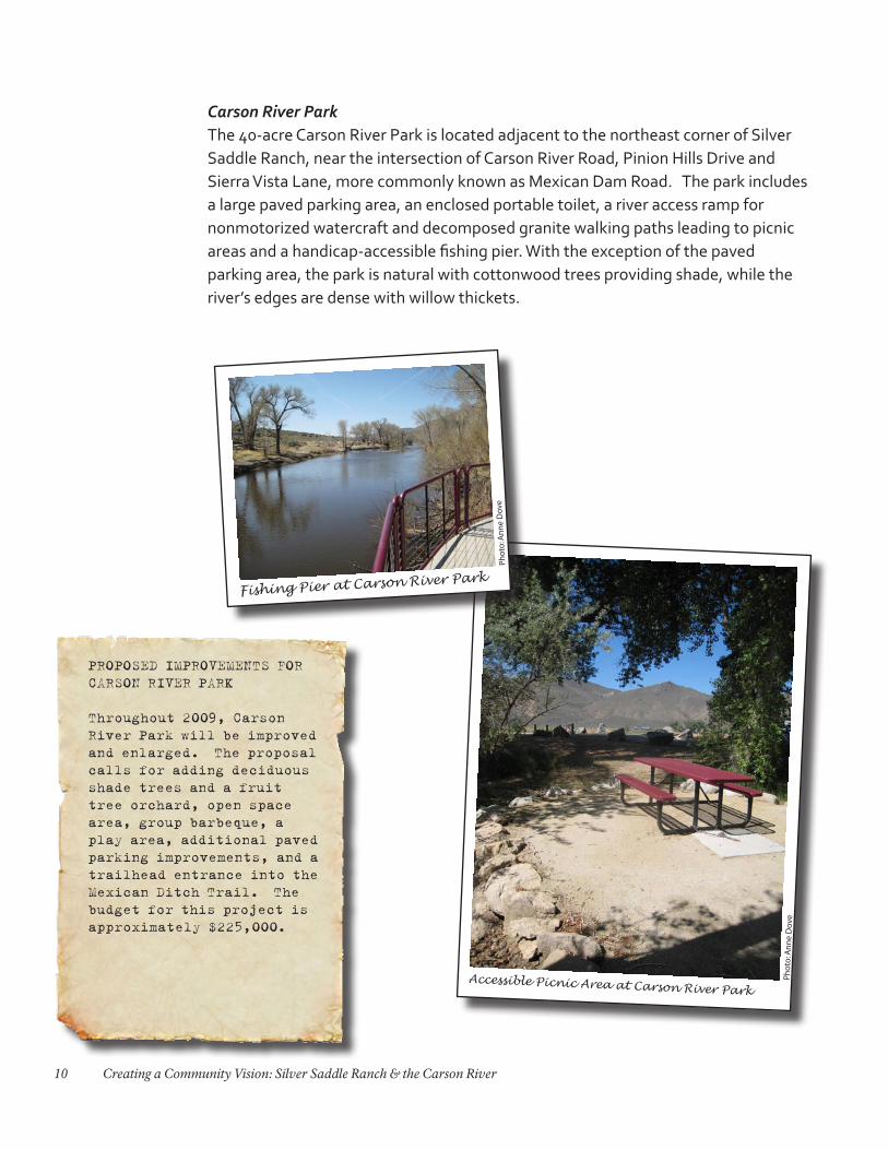
Carson River ParkThe 40-acre Carson River Park is located adjacent to the northeast corner of Silver Saddle Ranch, near the intersection of Carson River Road, Pinion Hills Drive and Sierra Vista Lane, more commonly known as Mexican Dam Road. The park includes a large paved parking area, an enclosed portable toilet, a river access ramp for nonmotorized watercraft and decomposed granite walking paths leading to picnic areas and a handicap-accessible fishing pier. With the exception of the paved parking area, the park is natural with cottonwood trees providing shade, while the river’s edges are dense with willow thickets.
PROPOSED IMPROVEMENTS FOR CARSON RIVER PARK
Throughout 2009, Carson River Park will be improved and enlarged. The proposal calls for adding deciduous shade trees and a fruit tree orchard, open space area, group barbeque, a play area, additional paved parking improvements, and a trailhead entrance into the Mexican Ditch Trail. The budget for this project is approximately $225,000.
Accessible Picnic Area at Carson River Park
Pho
to: A
nn
e D
ove
Pho
to: A
nn
e D
ove
Fishing Pier at Carson River Park
11Background: Purpose of the Charrette
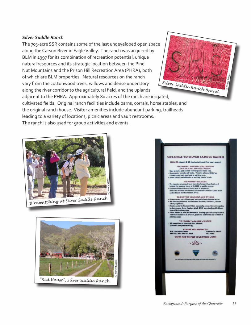
Silver Saddle Ranch The 703-acre SSR contains some of the last undeveloped open space along the Carson River in Eagle Valley. The ranch was acquired by BLM in 1997 for its combination of recreation potential, unique natural resources and its strategic location between the Pine Nut Mountains and the Prison Hill Recreation Area (PHRA), both of which are BLM properties. Natural resources on the ranch vary from the cottonwood trees, willows and dense understory along the river corridor to the agricultural field, and the uplands adjacent to the PHRA. Approximately 80 acres of the ranch are irrigated, cultivated fields. Original ranch facilities include barns, corrals, horse stables, and the original ranch house. Visitor amenities include abundant parking, trailheads leading to a variety of locations, picnic areas and vault restrooms. The ranch is also used for group activities and events.
“Red House”, Silver Saddle Ranch
(c)
Nan
cy S
anto
s
Birdwatching at Silver Saddle Ranch
(c) N
ancy
San
tos
(c) N
ancy
San
tos
Silver Saddle Ranch Brand
12 Creating a Community Vision: Silver Saddle Ranch & the Carson River
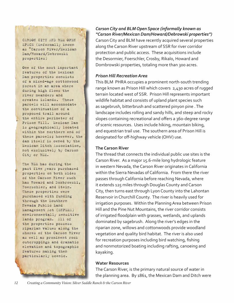
Carson City and BLM Open Space (informally known as “Carson River/Mexican Dam/Howard/Debrowski properties”)Carson City and BLM have recently acquired several properties along the Carson River upstream of SSR for river corridor protection and public access. These acquisitions include the Desormier, Foerschler, Crosby, Rikalo, Howard and Dombrowski properties, totaling more than 300 acres.
Prison Hill Recreation AreaThis BLM PHRA occupies a prominent north-south trending range known as Prison Hill which covers 2,430 acres of rugged terrain located west of SSR. Prison Hill represents important wildlife habitat and consists of upland plant species such as sagebrush, bitterbrush and scattered pinyon pine . The landscape includes rolling and sandy hills, and steep and rocky slopes containing recreational and offers a 360-degree range of scenic resources. Uses include hiking, mountain biking, and equestrian trail use. The southern area of Prison Hill is designated for off-highway vehicle (OHV) use.
The Carson RiverThe thread that connects the individual public use sites is the Carson River. As a major 15.6-mile long hydrologic feature in western Nevada, the Carson River originates in California within the Sierra Nevadas of California. From there the river passes through California before reaching Nevada, where it extends 125 miles through Douglas County and Carson City, then turns east through Lyon County into the Lahontan Reservoir in Churchill County. The river is heavily used for irrigation purposes. Within the Planning Area between Prison Hill and the Pine Nut Mountains, the river corridor consists of irrigated floodplain with grasses, wetlands, and uplands dominated by sagebrush. Along the river’s edges in the riparian zone, willows and cottonwoods provide woodland vegetation and quality bird habitat. The river is also used for recreation purposes including bird watching, fishing and nonmotorized boating including rafting, canoeing and kayaking.
Water ResourcesThe Carson River, is the primary natural source of water in the planning area. By 1861, the Mexican Dam and Ditch were
CARSON CITY AND BLM OPEN SPACE (informally known as “Carson River/Mexican Dam/Howard/Debrowski properties)
One of the most important features of the Mexican Dam properties consists of a mixed-age cottonwood forest in an area where during high flows the river meanders and creates islands. These parcels will accommodate the continuation of a proposed trail around the entire perimeter of Prison Hill. Mexican Dam is geographically located within the northern end of these parcels; however, the dam itself is owned by the Mexican Ditch Association, not exclusively by Carson City or BLM.
The BLM has during the past five years purchased properties on both sides of the Carson River such has Howard and Dombrowski, Foerschler, and Stein. These properties were purchased with funding through the Southern Nevada Public Land Management Act (SNPLMA) environmentally sensitive lands program. All of the properties possess riparian values along the shores of the Carson River as well as prominent rock outcroppings and dramatic elevation and topographic features making then particularly scenic.
13Background: Purpose of the Charrette
constructed to divert water from the river to the Mexican Mill located approximately ¼-mile from the Carson River Ambrose Natural Area. The Mexican Ditch today provides water to Silver Saddle Ranch and other downstream users north of Silver Saddle Ranch.
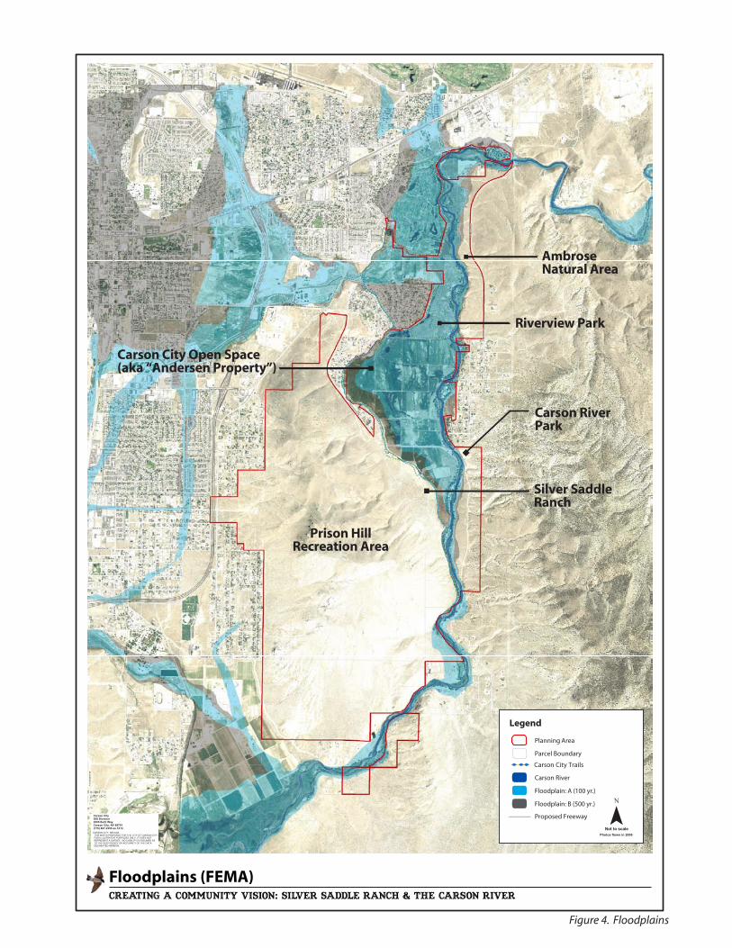
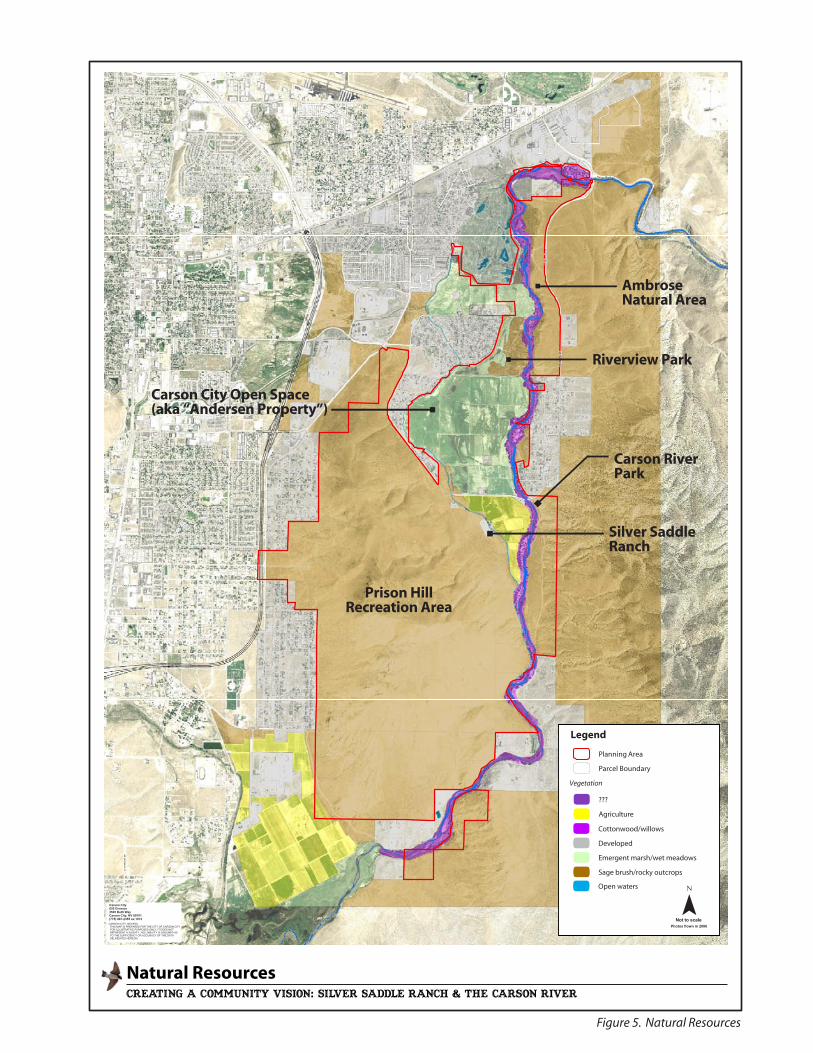
Natural ResourcesThe Planning Area contains a broad range of natural resources. The river corridor includes largely contiguous riparian vegetation with adjacent emergent wetlands within the Carson River floodplain (Figure 4: Floodplains; Figure 5: Natural Resources). Upland areas of the Planning Area are characterized by sagebrush and rocky outcrops. Irrigated pastures also function as habitat. The Planning Area provides habitat for a wide range of animal species including at least 57 bird species and 12 mammalian species that are known to either be present or expected to occur within the Planning Area.
Cultural/Historic ResourcesThe Planning Area was traditionally home to the Washoe people, with a long oral history and occupation of the area prior to the arrival of European-Americans in the mid-1800s. The Washoe primarily used the area for gathering plants and hunting. The first known agricultural development of the Silver Saddle Ranch area dates to 1862. After 1864, Silver Saddle Ranch was divided into five blocks of land. In 1956 the Chartz-Herlax Ranch and the Bird-Urich Ranch were joined and became Silver Saddle Ranch. The descendants of the owners Mr. and Mrs. Merchant sold the property to BLM in 1997. SSR today retains 13 ranch-related buildings dated from the 1920-1980s.
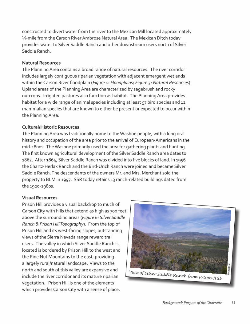
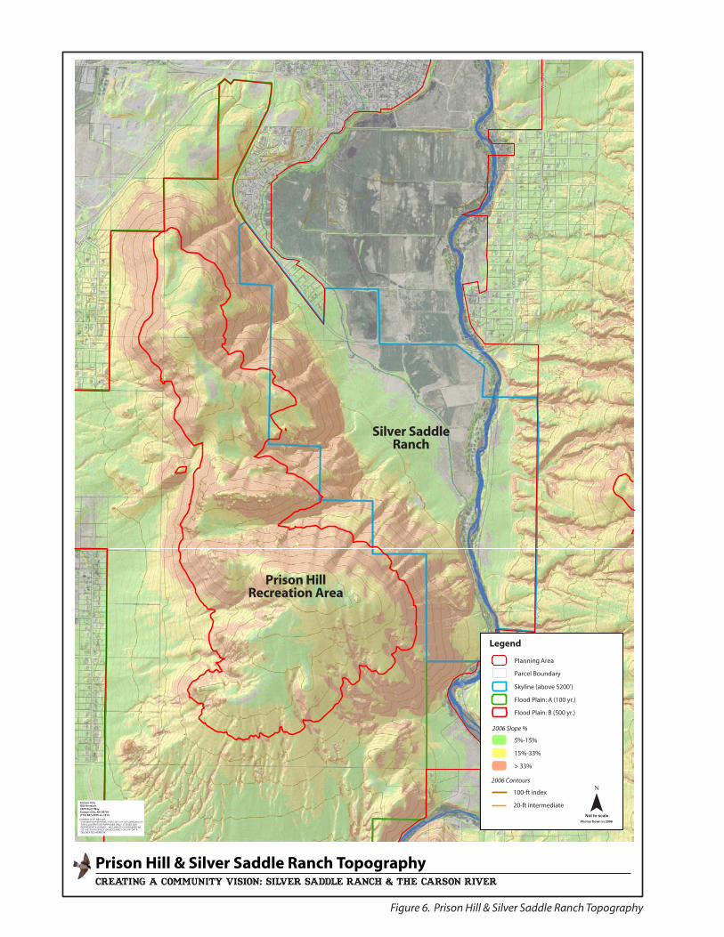
Visual ResourcesPrison Hill provides a visual backdrop to much of Carson City with hills that extend as high as 700 feet above the surrounding areas (Figure 6: Silver Saddle Ranch & Prison Hill Topography). From the top of Prison Hill and its west-facing slopes, outstanding views of the Sierra Nevada range reward trail users. The valley in which Silver Saddle Ranch is located is bordered by Prison Hill to the west and the Pine Nut Mountains to the east, providing a largely rural/natural landscape. Views to the north and south of this valley are expansive and include the river corridor and its mature riparian vegetation. Prison Hill is one of the elements which provides Carson City with a sense of place.
Pho
to: B
LM
View of Silver Saddle Ranch from Prison Hill
HWY 50 E
E 5TH ST
SB395
NB
395
FARI
VEI
WD
RYP EGELL
OC
NRO
OP
ST
SED
MO
ND
SD
R
SNYDER AV
E LONG ST
SRO
OP
ST
SCA
RSN
OST
ND
EER
R UN
RD
NCA
RSO
NST
CARSONRIVER
RD
NLO
PM
ALN
COLORADO ST
AIR
POR T
RD
ARROWHEAD DRS
CURR
YST
SD
EER
R UN
R D
NORTHRIDGE DR
SSA
LIM
AN
R D
E WILLIAM ST
NSA
LIM
AN
RD
SST
EWA
RTST
CARMINE ST
HOTSP
RINGS
RD
GON
IRD
NST
EWA
RTST
R USS
E LL
WY
PIN
ION
HIL
LSD
R
E MUSSER ST
KOONTZ LN
E NYE LN
SILV
ERSA
G ED
R
NS U
NRI
DG E
DR
W NYE LN
E WINNIE LN
CLEARVIEW DR
LITTLE LN
E WASHINGTON ST
EAGLE STATION LN
JUNIPER RD
RETA
ILDR
W LONG ST
W 5TH ST
WINNIE LN
SILV
ERSA
GED
R
¯Not to scale
Photos flown in 2006
creating a community vision: silver Saddle Ranch & The Carson River
Carson CityGIS Division3505 Butti WayCarson City, NV 89701(775) 887-2355 ex.1013CARSON CITY, NEVADA THIS MAP IS PREPARED FOR THE CITY OF CARSON CITY FOR ILLUSTRATIVE PURPOSES ONLY, IT DOES NOT REPRESENT A SURVEY. NO LIABILITY IS ASSUMED AS TO THE SUFFICIENCY OR ACCURACY OF THE DATA DELINEATED HEREON.
XW XW XW
Figure 4. Floodplains
HWY 50 E
E 5TH ST
SB395
NB
395
YP EGELLOC
FARI
VEI
WD
R
SCA
RSN
OST
NR O
OP
ST
SED
MO
ND
SD
R
SC U
R RY
ST
SNYDER AV
NCA
RSO
NST
E LONG ST
SRO
OP
S T
ND
EER
R UN
R D
CARSONRIVER
RD
NLO
MPA
L N
COLORADO ST
AIR
PORT
RD
ARROWHEAD DR
SD
EER
RUN
R D
NORTHRIDGE DR
SSA
LIM
AN
R D
E WILLIAM ST
NSA
LIM
AN
RD
SST
EWA
RTST
CARMINE ST
HOTSP
RINGS
RD
KOONTZ LN
GON
IRD
NST
EWA
RTST
RUS S
E LL
WY
CLEARVIEW DR
NSU
NR I
DGE
DR
PIN
I ON
HIL
L SD
R
W NYE LN
E MUSSER ST
E NYE LN
SILV
ERSA
G ED
R
EAGLE STATION LN
E WINNIE LN
LITTLE LN
E WASHINGTON ST
W 5TH ST
RHOD SE ST
TOPSY
W LONG ST
SD
IVI S
I ON
ST
W WINNIE LN
JUNIPER RD
W KI GN ST
RETAIL
DR
W WAS IH NGTON ST
MOSES ST
SILV
ERSA
G ED
R
¯Not to scale
Photos flown in 2006
creating a community vision: silver Saddle Ranch & The Carson River
Carson CityGIS Division3505 Butti WayCarson City, NV 89701(775) 887-2355 ex.1013CARSON CITY, NEVADA THIS MAP IS PREPARED FOR THE CITY OF CARSON CITY FOR ILLUSTRATIVE PURPOSES ONLY, IT DOES NOT REPRESENT A SURVEY. NO LIABILITY IS ASSUMED AS TO THE SUFFICIENCY OR ACCURACY OF THE DATA DELINEATED HEREON.
Figure 5. Natural Resources
E 5TH ST
CARSONRIVER
RD
FAIR
IVEW
DR
SD
ERE
URN
RD
PIN
I ON
HIL
L SD
R
JUNIPER RD
SED
MON
DSDR
E 5TH ST
¯Not to scale
Photos flown in 2006
creating a community vision: silver Saddle Ranch & The Carson River
Carson CityGIS Division3505 Butti WayCarson City, NV 89701(775) 887-2355 ex.1013CARSON CITY, NEVADA THIS MAP IS PREPARED FOR THE CITY OF CARSON CITY FOR ILLUSTRATIVE PURPOSES ONLY, IT DOES NOT REPRESENT A SURVEY. NO LIABILITY IS ASSUMED AS TO THE SUFFICIENCY OR ACCURACY OF THE DATA DELINEATED HEREON.
Figure 6. Prison Hill & Silver Saddle Ranch Topography
17Background: Purpose of the Charrette
Planning FrameworkCarson City and BLM have undertaken a number of past planning efforts that affect the Silver Saddle Ranch and Carson River planning area. However, no one plan encompasses the entire Planning Area. There is a need to have a central plan, particularly given the anticipated changes in land ownership and management responsibilities. The planning team identified the relevant planning documents, goals and objectives from the wide array of existing plans that affect this area (Appendix B: Silver Saddle Ranch and Carson River Area Planning Framework). Relevant plans include but are not limited to:
Carson City:
• CarsonCityComprehensiveMasterPlan(2006):The Master Plan is an officially adopted policy document that outlines Carson City’s vision and goals for the future and provides guidance for elected and appointed officials in making decisions regarding the long-range needs of the community. The written goals and guiding principles, policies, and recommended actions, in combination with the Land Use Map, provide a basis for decisions affecting growth, the use and development of land, preservation of open space and the expansion of public facilities and services.
• CarsonCityParksandRecreationMasterPlan(2006). The purpose of the Parks and Recreation Master Plan is to identify the recreation needs of today’s residents, to anticipate those of tomorrow, and to assure they will be met through proper planning.
• UnifiedPathwaysMasterPlan(2006). This document is a comprehensive plan for non-automobile travel routes in and around Carson City. The title “Path ways” refers to the many different types of routes that are included: trails, sidewalks, bike lanes, off-street multi-use trails and even an “aquatic trail” along the Carson River which was added to a revised version of the plan in 2007.
• CarsonCityOpenSpacePlan(2000). In 1996, the citizens of Carson City approved a ballot question entitled “#18: Quality of Life Initiative” that authorized a ¼ -cent sales tax to fund open space, parks and trails. This open space plan was developed to guide the use of these funds and to identify other means to preserve open space.

18 Creating a Community Vision: Silver Saddle Ranch & the Carson River
• CarsonRiverMasterPlan(1996). The master plan represents a starting point that guides the implementation of policy and development of improvement projects for the Carson River area.
Bureau of Land Management:
• Interdisciplinary Management Plan for Silver Saddle Ranch and the AmbroseCarsonRiverNaturalArea(2000). This purpose of this plan is to identify issues and outline goals, objectives and management actions that are ecologically sound, economically feasible and socially acceptable. The intent is for this plan to resolve issues and problems through specific on-the-ground actions that do not require additional analysis or planning.
• CarsonCityUrbanInterfacePlanAmendment(1996). This document was prepared jointly with the City of Carson City and provides an amendment to the existing Walker Resource Management Plan to provide for improved management of public lands adjacent to the community of Carson City. This plan provided for the withdrawal of mining uses from the interface lands on the Pinyon Hills and Virginia Range surrounding the Eagle Valley.