Embed Size (px)
Citation preview
10 Science Highlights
PAGES NEWS, VOL.9, N°2, JULY 2001
Over the last ten years, interest in high resolution (decadal to annual) paleoclimatic studies has grown rapidly. The climate system contains numerous processes on subdecadal time scales, for example the “North Atlantic Oscillation” (NAO) and the “El Niño–Southern Oscillation” (ENSO). In order to capture such modes, it is necessary to investigate paleoclimate with annual resolution. A broad range of high resolution paleoclimatic records with annual or subannual resolution (e. g. ice cores, corals, and tree rings) are available for the late Holocene. Further back in time the records are scarce.
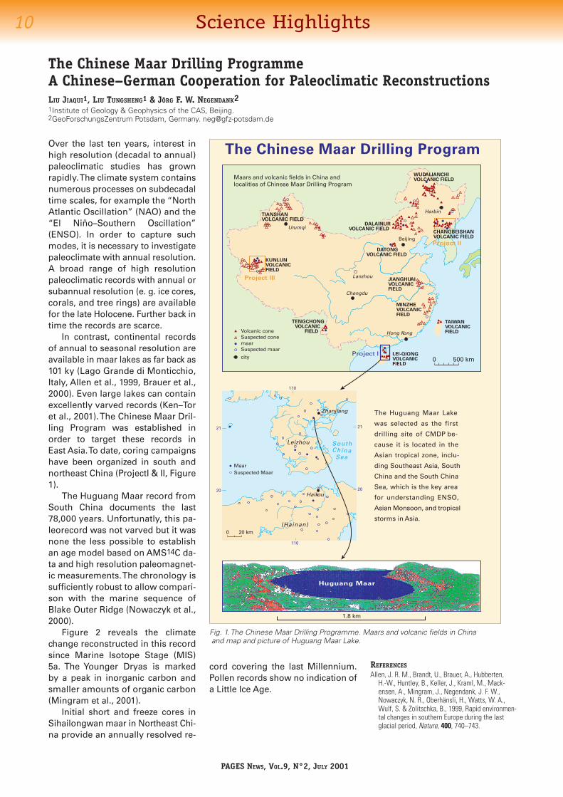
In contrast, continental records of annual to seasonal resolution are available in maar lakes as far back as 101 ky (Lago Grande di Monticchio, Italy, Allen et al., 1999, Brauer et al., 2000). Even large lakes can contain excellently varved records (Ken–Tor et al., 2001). The Chinese Maar Dril-ling Program was established in order to target these records in East Asia. To date, coring campaigns have been organized in south and northeast China (ProjectI & II, Figure 1).
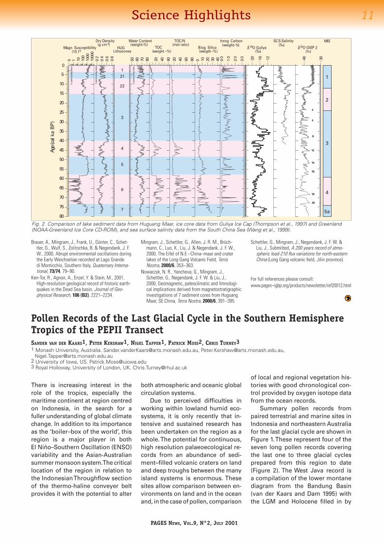
The Huguang Maar record from South China documents the last 78,000 years. Unfortunatly, this pa-leorecord was not varved but it was none the less possible to establish an age model based on AMS14C da-ta and high resolution paleomagnet-ic measurements. The chronology is sufficiently robust to allow compari-son with the marine sequence of Blake Outer Ridge (Nowaczyk et al., 2000).
Figure 2 reveals the climate change reconstructed in this record since Marine Isotope Stage (MIS) 5a. The Younger Dryas is marked by a peak in inorganic carbon and smaller amounts of organic carbon (Mingram et al., 2001).
Initial short and freeze cores in Sihailongwan maar in Northeast Chi-na provide an annually resolved re-
The Chinese Maar Drilling ProgrammeA Chinese–German Cooperation for Paleoclimatic ReconstructionsLIU JIAQUI1, LIU TUNGSHENG1 & JÖRG F. W. NEGENDANK21Institute of Geology & Geophysics of the CAS, Beijing.2GeoForschungsZentrum Potsdam, Germany. [email protected]
Fig. 1. The Chinese Maar Drilling Programme. Maars and volcanic fields in China and map and picture of Huguang Maar Lake.
The Huguang Maar Lake
was selected as the first
drilling site of CMDP be-
cause it is located in the
Asian tropical zone, inclu-
ding Southeast Asia, South
China and the South China
Sea, which is the key area
for understanding ENSO,
Asian Monsoon, and tropical
storms in Asia.
The Chinese Maar Drilling Program
Leizhou SouthChina
Sea
20
21
110
110
20
21
0 20 km
Project III
Project I
Harbin
Beijing
Lanzhou
Chengdu
Hong Kong
DATONGVOLCANIC FIELD
LEI-QIONGVOLCANICFIELD
TAIWANVOLCANICFIELD
MINZHEVOLCANICFIELD
JIANGHUAIVOLCANICFIELD
DALAINURVOLCANIC FIELD
WUDALIANCHIVOLCANIC FIELD
CHANGBEISHANVOLCANIC FIELDProject II
KUNLUNVOLCANICFIELD
Urumqi
TENGCHONG VOLCANIC FIELD
TIANSHANVOLCANIC FIELD
500 km0
Huguang Maar
1.8 km
Volcanic coneSuspected conemaarSuspected maar
city
Zhanjiang
Haikou
Qiongzhou(Hainan)
MaarSuspected Maar
Maars and volcanic fields in China andlocalities of Chinese Maar Drilling Program
cord covering the last Millennium. Pollen records show no indication of a Little Ice Age.
REFERENCESAllen, J. R. M., Brandt, U., Brauer, A., Hubberten,
H.-W., Huntley, B., Keller, J., Kraml, M., Mack-ensen, A., Mingram, J., Negendank, J. F. W., Nowaczyk, N. R., Oberhänsli, H., Watts, W. A., Wulf, S. & Zolitschka, B., 1999, Rapid environmen-tal changes in southern Europe during the last glacial period, Nature, 400, 740–743.
11Science Highlights
PAGES NEWS, VOL.9, N°2, JULY 2001
Fig. 2. Comparison of lake sediment data from Huguang Maar, ice core data from Guliya Ice Cap (Thompson et al., 1997) and Greenland (NOAA-Greenland Ice Core CD-ROM), and sea surface salinity data from the South China Sea (Wang et al., 1999).
0
5
10
15
20
25
30
35
40
45
50
55
60
65
70
75
80
0 1 10 100
1000
1000
0
50 60 70 80 0.0
1.0
2.0
3.0
Magn. Susceptibility(10 )
Dry Density(g cm )
Inorg. Carbon(weight–%)
20 40 60
TOC(weight –%)
0 10 20 30 40
Biog. Silica(weigth–%)
0.2
0.4
0.6
0.8
Water Content(weight–%)
20 40 60 80
TOC/N(mol ratio)
Age
(cal
ka
BP
)
- 40
- 30
SCS Salinity
O GISP 2( )
11po
intr
unni
ngm
ean
5po
intr
unni
ngm
ean
5po
intr
unni
ngm
ean
- 20
- 16
- 12
O Guliya( )
MIS
‰‰18 18δ δ
-6HUG
Lithozones
3
5
7
8
12
14
16
4
2
19
20
11
22
33
44
5a5a
- 3 ( )‰
211
22
4
6
Brauer, A., Mingram, J., Frank, U., Günter, C., Schet-tler, G., Wulf, S., Zolitschka, B. & Negendank, J. F. W., 2000, Abrupt environmental oscillations during the Early Weichselian recorded at Lago Grande di Monticchio, Southern Italy, Quaternary Interna-tional, 73/74, 79–90.
Ken-Tor, R., Agnon, A., Enzel, Y. & Stein, M., 2001, High-resolution geological record of historic earth-quakes in the Dead Sea basin, Journal of Geo-physical Research, 106 (B2), 2221–2234.
Pollen Records of the Last Glacial Cycle in the Southern Hemisphere Tropics of the PEPII TransectSANDER VAN DER KAARS1, PETER KERSHAW1, NIGEL TAPPER1, PATRICK MOSS2, CHRIS TURNEY31 Monash University, Australia. [email protected], [email protected],
[email protected] 2 University of Iowa, US. [email protected] Royal Holloway, University of London, UK. [email protected]
There is increasing interest in the role of the tropics, especially the maritime continent at region centred on Indonesia, in the search for a fuller understanding of global climate change. In addition to its importance as the ‘boiler–box of the world’, this region is a major player in both El Niño–Southern Oscillation (ENSO) variability and the Asian-Australian summer monsoon system. The critical location of the region in relation to the Indonesian Throughflow section of the thermo-haline conveyer belt provides it with the potential to alter
both atmospheric and oceanic global circulation systems.
Due to perceived difficulties in working within lowland humid eco-systems, it is only recently that in-tensive and sustained research has been undertaken on the region as a whole. The potential for continuous, high resolution palaeoecological re-cords from an abundance of sedi-ment–filled volcanic craters on land and deep troughs between the many island systems is enormous. These sites allow comparison between en-vironments on land and in the ocean and, in the case of pollen, comparison
of local and regional vegetation his-tories with good chronological con-trol provided by oxygen isotope data from the ocean records.
Summary pollen records from paired terrestrial and marine sites in Indonesia and northeastern Australia for the last glacial cycle are shown in Figure 1. These represent four of the seven long pollen records covering the last one to three glacial cycles prepared from this region to date (Figure 2). The West Java record is a compilation of the lower montane diagram from the Bandung Basin (van der Kaars and Dam 1995) with the LGM and Holocene filled in by
Mingram, J., Schettler, G., Allen, J. R. M., Brüch-mann, C., Luo, X., Liu, J. & Negendank, J. F. W., 2000, The Eifel of N.E.–China–maar and crater lakes of the Long Gang Volcanic Field, Terra Nostra, 2000/6, 353–363.
Nowaczyk, N. R., Yancheva, G., Mingram, J., Schettler, G., Negendank, J. F. W. & Liu, J., 2000, Geomagnetic, paleoclimatic and limnologi-cal implications derived from magnetostratigraphic investigations of 7 sediment cores from Huguang Maar, SE China, Terra Nostra, 2000/6, 391–395.
Schettler, G., Mingram, J., Negendank, J. F. W. & Liu, J., Submitted, A 200 years record of atmo-spheric lead-210 flux variations for north-eastern China (Long Gang volcanic field, Jilin province).
For full references please consult:www.pages–igbp.org/products/newsletter/ref20012.html