Embed Size (px)
Citation preview
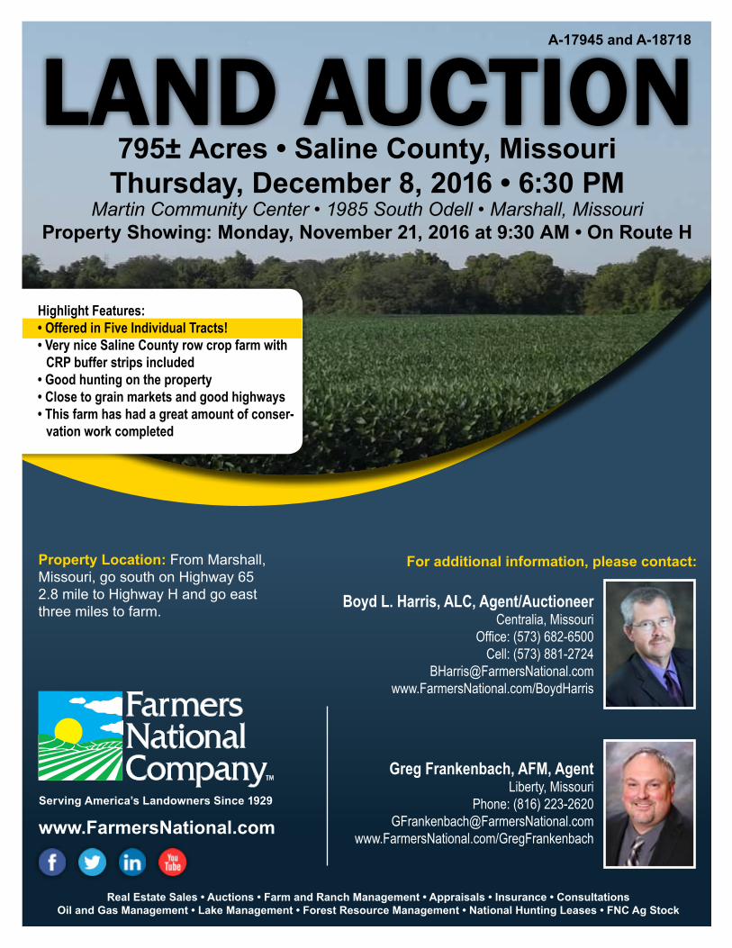
Real Estate Sales • Auctions • Farm and Ranch Management • Appraisals • Insurance • Consultations Oil and Gas Management • Lake Management • Forest Resource Management • National Hunting Leases • FNC Ag Stock
www.FarmersNational.com
Greg Frankenbach, AFM, AgentLiberty, Missouri
Phone: (816) [email protected]
www.FarmersNational.com/GregFrankenbach
Boyd L. Harris, ALC, Agent/AuctioneerCentralia, Missouri
Office: (573) 682-6500Cell: (573) 881-2724
[email protected]/BoydHarris
For additional information, please contact:
A-17945 and A-18718
Serving America’s Landowners Since 1929
LAND AUCTION795± Acres • Saline County, Missouri
Thursday, December 8, 2016 • 6:30 PMMartin Community Center • 1985 South Odell • Marshall, Missouri
Property Showing: Monday, November 21, 2016 at 9:30 AM • On Route H
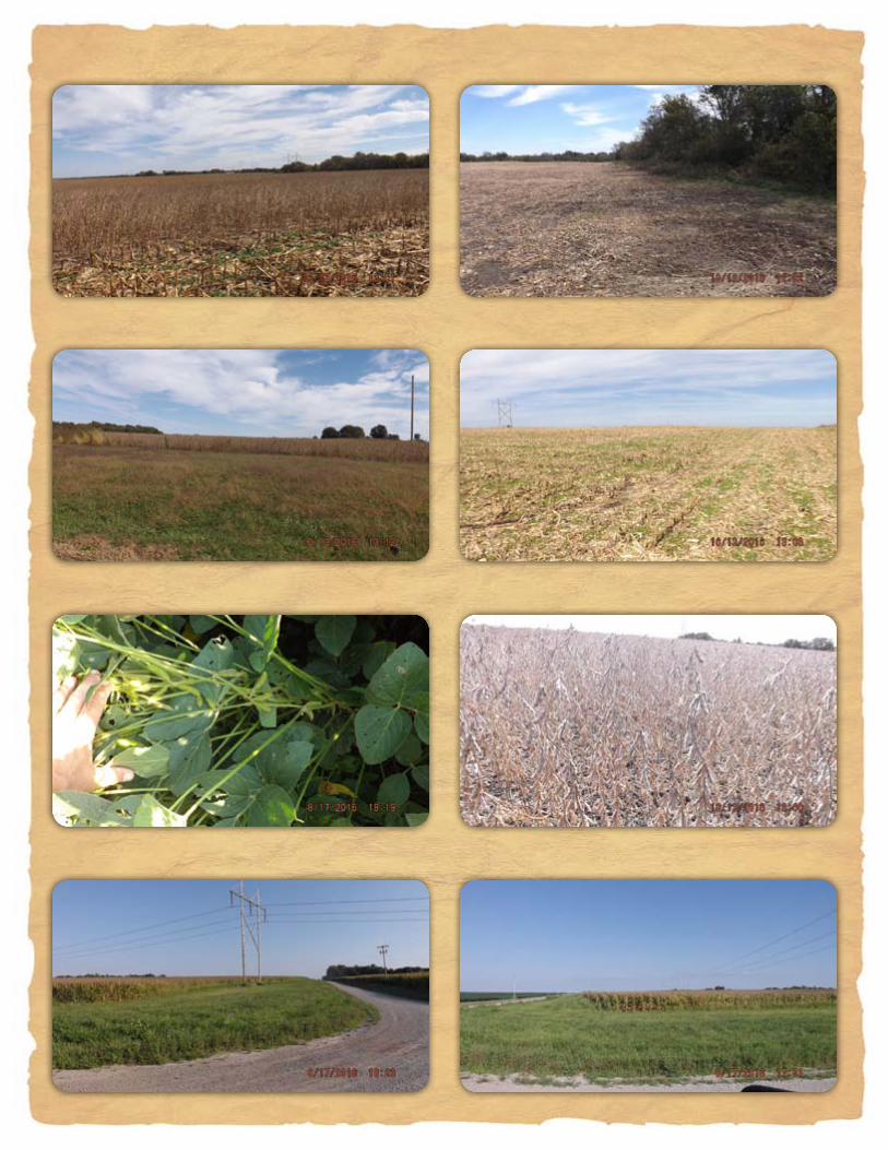
Highlight Features:• Offered in Five Individual Tracts!• Very nice Saline County row crop farm with
CRP buffer strips included• Good hunting on the property• Close to grain markets and good highways• This farm has had a great amount of conser-
vation work completed
Property Location: From Marshall, Missouri, go south on Highway 65 2.8 mile to Highway H and go east three miles to farm.
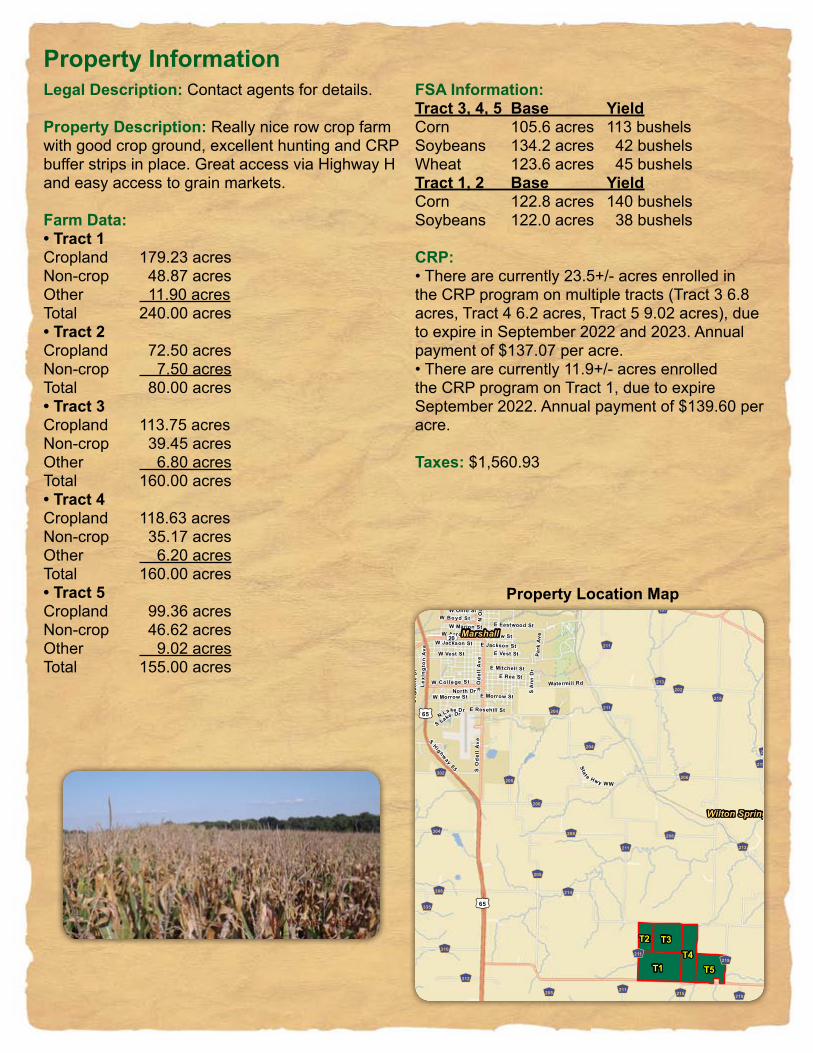
Legal Description: Contact agents for details.
Property Description: Really nice row crop farm with good crop ground, excellent hunting and CRP buffer strips in place. Great access via Highway H and easy access to grain markets.
Farm Data:• Tract 1Cropland 179.23 acresNon-crop 48.87 acresOther 11.90 acresTotal 240.00 acres• Tract 2Cropland 72.50 acresNon-crop 7.50 acresTotal 80.00 acres• Tract 3Cropland 113.75 acresNon-crop 39.45 acresOther 6.80 acresTotal 160.00 acres• Tract 4Cropland 118.63 acresNon-crop 35.17 acresOther 6.20 acresTotal 160.00 acres• Tract 5Cropland 99.36 acresNon-crop 46.62 acresOther 9.02 acresTotal 155.00 acres
FSA Information:Tract 3, 4, 5 Base YieldCorn 105.6 acres 113 bushelsSoybeans 134.2 acres 42 bushelsWheat 123.6 acres 45 bushelsTract 1, 2 Base YieldCorn 122.8 acres 140 bushelsSoybeans 122.0 acres 38 bushels
CRP:• There are currently 23.5+/- acres enrolled in the CRP program on multiple tracts (Tract 3 6.8 acres, Tract 4 6.2 acres, Tract 5 9.02 acres), due to expire in September 2022 and 2023. Annual payment of $137.07 per acre.• There are currently 11.9+/- acres enrolled the CRP program on Tract 1, due to expire September 2022. Annual payment of $139.60 per acre.
Taxes: $1,560.93
Property Information
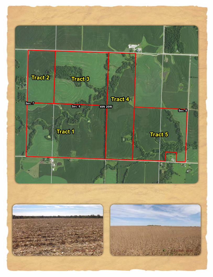
Property Location Map
T1T4
T3
T5
T2
W Arrow St
S O
del
l A
ve
N M
iami A
ve
W College St
S Highway 65
W Boyd St
Lexi
ng
ton
Ave
S O
del
l A
ve
E Eastwood St
Sta t e Hwy WW
W Vest St
E Rea StWatermill Rd
E Vest St
E Slater St
E Mitchell St
N O
dell
Ave
W Morrow St
W Jackson St
Ridge St
Park
AveE Arrow St
Ode
llA
v e
E Lacy St
North DrE Morrow St
S Lake Dr
Meyers Lake Rd
N Lake Dr
Felix St
E Rosehill St
W Marion St
S A
nn D
r
W Ohio St
S A
pach
e D
rIn
dust
rial
Dr
E Jackson St
Marshall
Montague Hill
Wilton Springs
GG205
GG214
GG202
GG215
GG206
GG213
GG211
GG208
GG306
GG302
GG212
GG304
GG310
GG312
GG111
GG219
GG109
GG204
GG107
GG335
GG219
GG206
GG204
GG107
GG211
GG211
GG211
GG215
GG208
GG205
GG219GG205
GG206
GG211
£¤65
£¤65
ST41
ST20
ST240
Latitude: 39.0841°NLongitude: -93.1616°WImagery Source: USDA NAIP Soil Data Source: USDA NRCSBoundaries Are Approximate
Thomas Bryan Hall III TrustSaline County, Missouri
49N 20W
Sec. 8Sec. 7
Sec. 17Sec. 18
Tract 1
Tract 3
Tract 4
Tract 2
Latitude: 39.0382°NLongitude: -93.1380°WImagery Source: USDA NAIP Soil Data Source: USDA NRCSBoundaries Are Approximate
Thomas Bryan Hall III TrustSaline County, Missouri
49N 20W
Sec. 7Sec. 8
Sec. 6 Sec. 5
Tract 2Tract 3
Tract 1
Latitude: 39.0455°NLongitude: -93.1424°WImagery Source: USDA NAIP Soil Data Source: USDA NRCSBoundaries Are Approximate
Thomas Bryan Hall III TrustSaline County, Missouri
49N 20W
Sec. 7Sec. 8
Sec. 6 Sec. 5
10077
10025
10077
10004
10025
1007710004
Tract 2
Tract 3
Tract 1
Latitude: 39.0455°NLongitude: -93.1424°WImagery Source: USDA NAIP Soil Data Source: USDA NRCSBoundaries Are Approximate
Thomas Bryan Hall III TrustSaline County, Missouri
MAP NON IRRSYMBOL NAME LCC ACRES
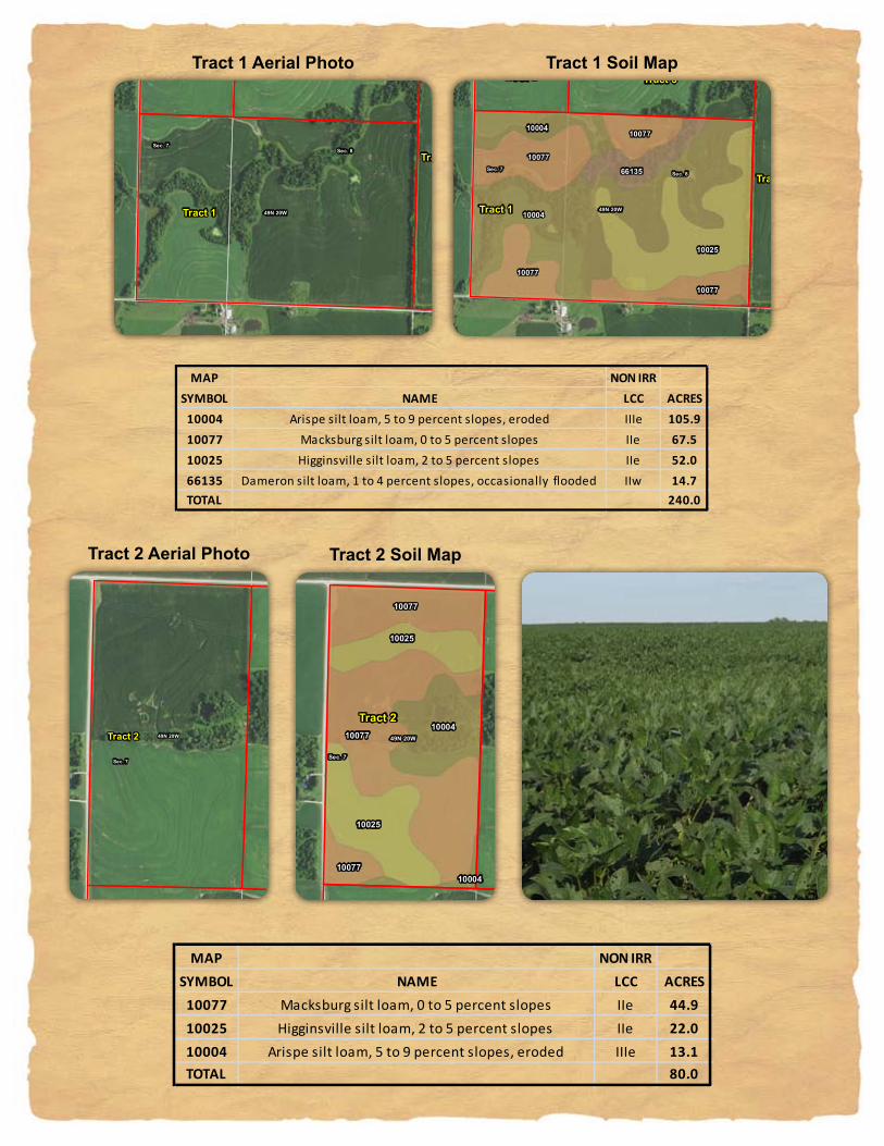
10077 Macksburg silt loam, 0 to 5 percent slopes IIe 44.910025 Higginsville silt loam, 2 to 5 percent slopes IIe 22.010004 Arispe silt loam, 5 to 9 percent slopes, eroded IIIe 13.1TOTAL 80.0
49N 20W
Sec. 8Sec. 7
Sec. 17Sec. 18
10004
10025
10077
10004
10077
10077
66135
10077
Tract 1
Tract 3
Tract 4
Tract 2
Latitude: 39.0382°NLongitude: -93.1380°WImagery Source: USDA NAIP Soil Data Source: USDA NRCSBoundaries Are Approximate
Thomas Bryan Hall III TrustSaline County, Missouri
MAP NON IRRSYMBOL NAME LCC ACRES10004 Arispe silt loam, 5 to 9 percent slopes, eroded IIIe 105.910077 Macksburg silt loam, 0 to 5 percent slopes IIe 67.510025 Higginsville silt loam, 2 to 5 percent slopes IIe 52.066135 Dameron silt loam, 1 to 4 percent slopes, occasionally flooded IIw 14.7TOTAL 240.0
49N 20W
Sec. 7Sec. 8
Sec. 6 Sec. 5
10077
10025
10077
10004
10025
1007710004
Tract 2
Tract 3
Tract 1
Latitude: 39.0455°NLongitude: -93.1424°WImagery Source: USDA NAIP Soil Data Source: USDA NRCSBoundaries Are Approximate
Thomas Bryan Hall III TrustSaline County, Missouri
MAP NON IRRSYMBOL NAME LCC ACRES
10077 Macksburg silt loam, 0 to 5 percent slopes IIe 44.910025 Higginsville silt loam, 2 to 5 percent slopes IIe 22.010004 Arispe silt loam, 5 to 9 percent slopes, eroded IIIe 13.1TOTAL 80.0
Tract 1 Aerial Photo
Tract 2 Aerial Photo
Tract 1 Soil Map
Tract 2 Soil Map
49N 20W
Sec. 8
Sec. 5
Sec. 7
Sec. 6
Tract 3
Tract 1
Tract 4
Tract 2
Latitude: 39.0453°NLongitude: -93.1354°WImagery Source: USDA NAIP Soil Data Source: USDA NRCSBoundaries Are Approximate
Thomas Bryan Hall III TrustSaline County, Missouri
49N 20WSec. 8
Sec. 9
Sec. 5
Sec. 17
Sec. 4
Sec. 16
Tract 4
Tract 3
Tract 5Tract 1
Latitude: 39.0415°NLongitude: -93.1285°WImagery Source: USDA NAIP Soil Data Source: USDA NRCSBoundaries Are Approximate
Thomas Bryan Hall III TrustSaline County, Missouri
49N 20W
10077
10004
10025
10027
10077
10027
10025
10004
66135
10004
Sec. 8
Sec. 9
Sec. 5
Sec. 17
Sec. 7
Sec. 4
Sec. 16
Sec. 6
Sec. 18
Tract 1
Tract 4
Tract 3
Tract 5
Tract 2
Latitude: 39.0415°NLongitude: -93.1285°WImagery Source: USDA NAIP Soil Data Source: USDA NRCSBoundaries Are Approximate
Thomas Bryan Hall III TrustSaline County, Missouri
MAP NON IRRSYMBOL NAME LCC ACRES
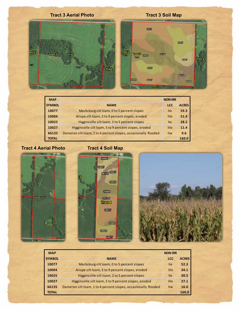
10077 Macksburg silt loam, 0 to 5 percent slopes IIe 52.310004 Arispe silt loam, 5 to 9 percent slopes, eroded IIIe 34.110025 Higginsville silt loam, 2 to 5 percent slopes IIe 30.510027 Higginsville silt loam, 5 to 9 percent slopes, eroded IIIe 27.166135 Dameron silt loam, 1 to 4 percent slopes, occasionally flooded IIw 16.0TOTAL 160.0
49N 20W10004
10077
10077
10025
10027
10025
66135
1000410004
Sec. 8Sec. 7
Sec. 5Sec. 6
Tract 3
Tract 4
Tract 2
Tract 1
Latitude: 39.0453°NLongitude: -93.1354°WImagery Source: USDA NAIP Soil Data Source: USDA NRCSBoundaries Are Approximate
Thomas Bryan Hall III TrustSaline County, Missouri
MAP NON IRRSYMBOL NAME LCC ACRES
10077 Macksburg silt loam, 0 to 5 percent slopes IIe 59.310004 Arispe silt loam, 5 to 9 percent slopes, eroded IIIe 51.410025 Higginsville silt loam, 2 to 5 percent slopes IIe 28.210027 Higginsville silt loam, 5 to 9 percent slopes, eroded IIIe 11.466135 Dameron silt loam, 1 to 4 percent slopes, occasionally flooded IIw 9.6TOTAL 160.0
49N 20W
10077
10004
10025
10027
10077
10027
10025
10004
66135
10004
Sec. 8
Sec. 9
Sec. 5
Sec. 17
Sec. 7
Sec. 4
Sec. 16
Sec. 6
Sec. 18
Tract 1
Tract 4
Tract 3
Tract 5
Tract 2
Latitude: 39.0415°NLongitude: -93.1285°WImagery Source: USDA NAIP Soil Data Source: USDA NRCSBoundaries Are Approximate
Thomas Bryan Hall III TrustSaline County, Missouri
MAP NON IRRSYMBOL NAME LCC ACRES
10077 Macksburg silt loam, 0 to 5 percent slopes IIe 52.310004 Arispe silt loam, 5 to 9 percent slopes, eroded IIIe 34.110025 Higginsville silt loam, 2 to 5 percent slopes IIe 30.510027 Higginsville silt loam, 5 to 9 percent slopes, eroded IIIe 27.166135 Dameron silt loam, 1 to 4 percent slopes, occasionally flooded IIw 16.0TOTAL 160.0
Tract 3 Aerial Photo
Tract 4 Aerial Photo
Tract 3 Soil Map
Tract 4 Soil Map
49N 20W
Sec. 8Sec. 9
Sec. 17Sec. 16
Tract 5
Tract 4
Latitude: 39.0377°NLongitude: -93.1216°WImagery Source: USDA NAIP Soil Data Source: USDA NRCSBoundaries Are Approximate
Thomas Bryan Hall III TrustSaline County, Missouri
10077
10077
10004
1002510004
10077
66132
49N 20W
Sec. 8Sec. 9
Sec. 17 Sec. 16
Tract 5
Tract 4
Latitude: 39.0377°NLongitude: -93.1216°WImagery Source: USDA NAIP Soil Data Source: USDA NRCSBoundaries Are Approximate
Thomas Bryan Hall III TrustSaline County, Missouri
MAP NON IRRSYMBOL NAME LCC ACRES
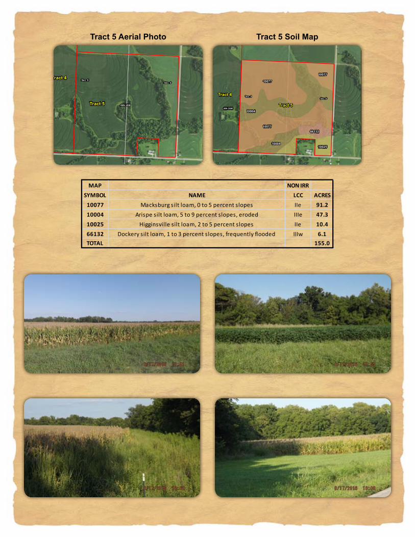
10077 Macksburg silt loam, 0 to 5 percent slopes IIe 91.210004 Arispe silt loam, 5 to 9 percent slopes, eroded IIIe 47.310025 Higginsville silt loam, 2 to 5 percent slopes IIe 10.466132 Dockery silt loam, 1 to 3 percent slopes, frequently flooded IIIw 6.1TOTAL 155.0
10077
10077
10004
1002510004
10077
66132
49N 20W
Sec. 8Sec. 9
Sec. 17 Sec. 16
Tract 5
Tract 4
Latitude: 39.0377°NLongitude: -93.1216°WImagery Source: USDA NAIP Soil Data Source: USDA NRCSBoundaries Are Approximate
Thomas Bryan Hall III TrustSaline County, Missouri
MAP NON IRRSYMBOL NAME LCC ACRES
10077 Macksburg silt loam, 0 to 5 percent slopes IIe 91.210004 Arispe silt loam, 5 to 9 percent slopes, eroded IIIe 47.310025 Higginsville silt loam, 2 to 5 percent slopes IIe 10.466132 Dockery silt loam, 1 to 3 percent slopes, frequently flooded IIIw 6.1TOTAL 155.0
Tract 5 Aerial Photo Tract 5 Soil Map
49N 20WSec. 8
Sec. 5
Sec. 17
Sec. 7
Sec. 9
Sec. 6Sec. 4
Sec. 18Sec. 16
Tract 1
Tract 4
Tract 3
Tract 5
Tract 2
Latitude: 39.0416°NLongitude: -93.1309°WImagery Source: USDA NAIP Soil Data Source: USDA NRCSBoundaries Are Approximate
Thomas Bryan Hall III TrustSaline County, Missouri
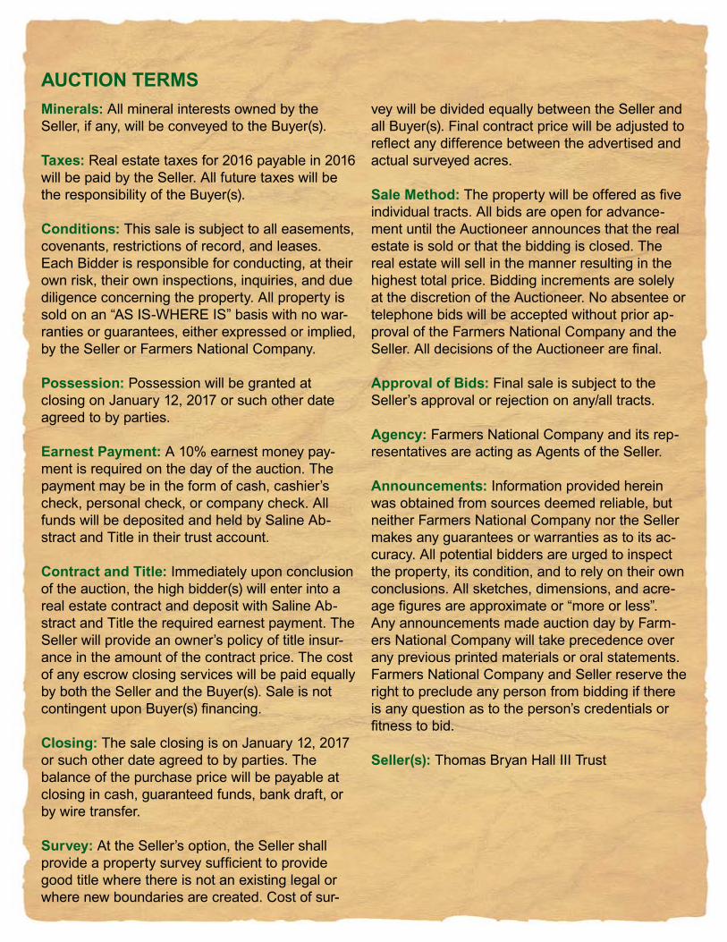
Minerals: All mineral interests owned by the Seller, if any, will be conveyed to the Buyer(s).
Taxes: Real estate taxes for 2016 payable in 2016 will be paid by the Seller. All future taxes will be the responsibility of the Buyer(s).
Conditions: This sale is subject to all easements, covenants, restrictions of record, and leases. Each Bidder is responsible for conducting, at their own risk, their own inspections, inquiries, and due diligence concerning the property. All property is sold on an “AS IS-WHERE IS” basis with no war-ranties or guarantees, either expressed or implied, by the Seller or Farmers National Company.
Possession: Possession will be granted at closing on January 12, 2017 or such other date agreed to by parties.
Earnest Payment: A 10% earnest money pay-ment is required on the day of the auction. The payment may be in the form of cash, cashier’s check, personal check, or company check. All funds will be deposited and held by Saline Ab-stract and Title in their trust account.
Contract and Title: Immediately upon conclusion of the auction, the high bidder(s) will enter into a real estate contract and deposit with Saline Ab-stract and Title the required earnest payment. The Seller will provide an owner’s policy of title insur-ance in the amount of the contract price. The cost of any escrow closing services will be paid equally by both the Seller and the Buyer(s). Sale is not contingent upon Buyer(s) financing.
Closing: The sale closing is on January 12, 2017 or such other date agreed to by parties. The balance of the purchase price will be payable at closing in cash, guaranteed funds, bank draft, or by wire transfer.
Survey: At the Seller’s option, the Seller shall provide a property survey sufficient to provide good title where there is not an existing legal or where new boundaries are created. Cost of sur-
vey will be divided equally between the Seller and all Buyer(s). Final contract price will be adjusted to reflect any difference between the advertised and actual surveyed acres. Sale Method: The property will be offered as five individual tracts. All bids are open for advance-ment until the Auctioneer announces that the real estate is sold or that the bidding is closed. The real estate will sell in the manner resulting in the highest total price. Bidding increments are solely at the discretion of the Auctioneer. No absentee or telephone bids will be accepted without prior ap-proval of the Farmers National Company and the Seller. All decisions of the Auctioneer are final.
Approval of Bids: Final sale is subject to the Seller’s approval or rejection on any/all tracts.
Agency: Farmers National Company and its rep-resentatives are acting as Agents of the Seller.
Announcements: Information provided herein was obtained from sources deemed reliable, but neither Farmers National Company nor the Seller makes any guarantees or warranties as to its ac-curacy. All potential bidders are urged to inspect the property, its condition, and to rely on their own conclusions. All sketches, dimensions, and acre-age figures are approximate or “more or less”. Any announcements made auction day by Farm-ers National Company will take precedence over any previous printed materials or oral statements. Farmers National Company and Seller reserve the right to preclude any person from bidding if there is any question as to the person’s credentials or fitness to bid.
Seller(s): Thomas Bryan Hall III Trust
AUCTION TERMS


![7 Catheter-associated Urinary Tract Infection (CAUTI) · UTI Urinary Tract Infection (Catheter-Associated Urinary Tract Infection [CAUTI] and Non-Catheter-Associated Urinary Tract](https://img.pdfslide.us/doc/110x75/5c40b88393f3c338af353b7f/7-catheter-associated-urinary-tract-infection-cauti-uti-urinary-tract-infection.jpg)