Embed Size (px)
Citation preview
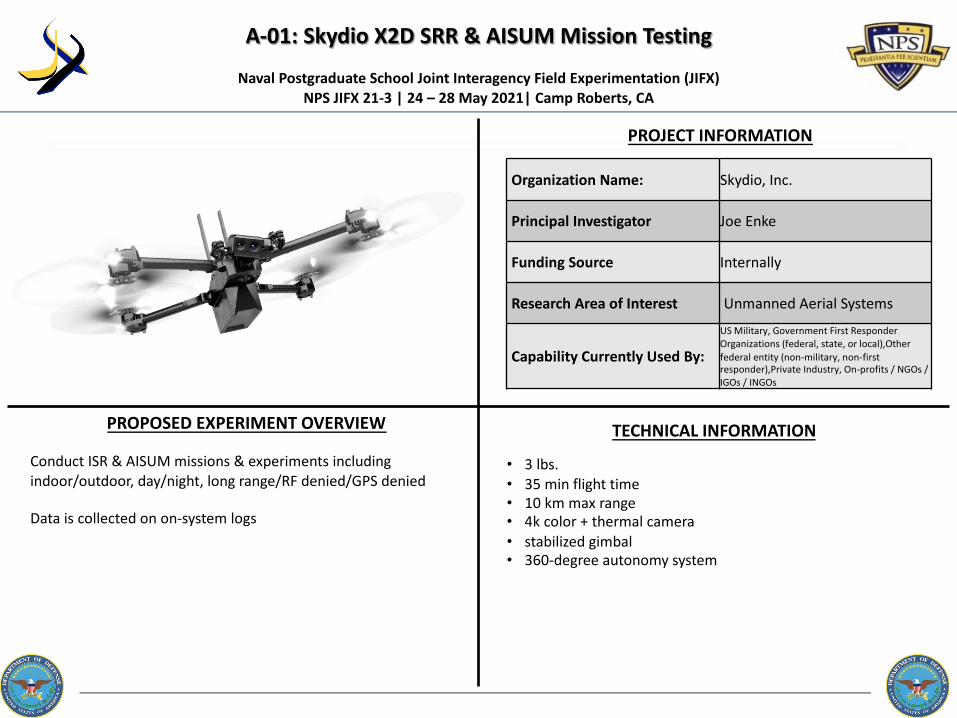
A-01: Skydio X2D SRR & AISUM Mission Testing
PROJECT INFORMATION
Naval Postgraduate School Joint Interagency Field Experimentation (JIFX) NPS JIFX 21-3 | 24 – 28 May 2021| Camp Roberts, CA
PROPOSED EXPERIMENT OVERVIEW TECHNICAL INFORMATION
• 3 lbs.• 35 min flight time• 10 km max range• 4k color + thermal camera• stabilized gimbal• 360-degree autonomy system
Conduct ISR & AISUM missions & experiments including indoor/outdoor, day/night, long range/RF denied/GPS denied
Data is collected on on-system logs
Organization Name: Skydio, Inc.
Principal Investigator Joe Enke
Funding Source Internally
Research Area of Interest Unmanned Aerial Systems
Capability Currently Used By:
US Military, Government First Responder Organizations (federal, state, or local),Other federal entity (non-military, non-first responder),Private Industry, On-profits / NGOs / IGOs / INGOs

A-02: Lightweight Hyperspectral Sensor Integration to Support Urban Air Mobility Operations
PROJECT INFORMATION
Naval Postgraduate School Joint Interagency Field Experimentation (JIFX) NPS JIFX 21-3 | 24 – 28 May 2021| Camp Roberts, CA
PROPOSED EXPERIMENT OVERVIEW TECHNICAL INFORMATION
eVTOL/UAM Experimentation PlatformMultirotor, 55lbsCoaxial Octocopter configurationFlight Duration: 17minFlight Control: PixhawkPower source: LiPo Battery
Our experiment will test the effectiveness of our hyperspectral sensor to detect and classify military items of interest (CARC painted military equipment such as uniforms, body armor, etc.), personnel during recovery operations, and the detection of hazardous materials. We intend to measure the accuracy of the hyperspectral sensor to detect and classify materials of interest while integrated with an electric Vertical Takeoff and Landing (eVTOL) drone flown at various altitudes, and under varying lighting, and weather conditions. The data collection plan will consist of post-flight sensor data analysis and accuracy measurements to confirm/deny the detection of materials of interest. We will perform multiple flights
each day and rotate the target materials of interest.
Organization Name: Spectrabotics, LLC
Principal Investigator Tim Haynie
Funding Source Federally
Research Area of Interest Unmanned Aerial Systems
Capability Currently Used By:US Military, Government First Responder Organizations (federal, state, or local),Private Industry, Non-profits / NGOs / IGOs / INGOs

A-03: Quantum Systems’ Trinity F90+ BVLOS Mission
PROJECT INFORMATION
Naval Postgraduate School Joint Interagency Field Experimentation (JIFX) NPS JIFX 21-3 | 24 – 28 May 2021| Camp Roberts, CA
PROPOSED EXPERIMENT OVERVIEW TECHNICAL INFORMATION
2.4 Meter wingspan VTOL with 5Kg payload90+ minutes*/ 60 minutes flight timewide range of high precision sensors, e.g. dual RGB & NDVI payload and 42 MP HighRes RGBPPK including Quantum-System iBase ground reference station powered by u-bloxPowerful motors for even more reserves in all situationsLive Air Traffic (ADS-B) incl. QBase 3D Mission Planning2.4 GHz telemetry with up to 7 km command & control rangeOptional ADS-B Mode-S transponder
Our experimentation goal is to fly a Beyond Visual Line of Sight (BVLOS) mission at Camp Roberts with the Trinity F90+ that is typically used for "line of site" missions with a Part 107 license. In addition, we have plans to fly an additional mission with a COA from our facility at the Monterey Bay Academy 4 miles off the coast, to perform a small mapping mission and return.
Organization Name: InsightUp Solutions
Principal Investigator Chris Bley
Funding Source Internally
Research Area of Interest Unmanned Aerial Systems
Capability Currently Used By:
Government First Responder Organizations (federal, state, or local), Other federal entity (non-military, non-first responder),Private Industry, Non-profits / NGOs / IGOs / INGOs

A-04: CATNIP
PROJECT INFORMATION
Naval Postgraduate School Joint Interagency Field Experimentation (JIFX) NPS JIFX 21-3 | 24 – 28 May 2021| Camp Roberts, CA
PROPOSED EXPERIMENT OVERVIEW TECHNICAL INFORMATION
Autonomous Sensor Emplacement System UAV PayloadRobotic Drill: 10” x 6” x 12”, Weight: 5 - 9 lbs.Sensor Payload Capacity: Sensors up to 3.3lbs
Octocopter: Main rotor diameter: 56" Max take-off weight: 24.5 lbs.
Fixed-wing VTOL:Wingspan: 12’ Length: 5’-6” longWeight: 50 lbs.
We plan to work with our improved sensor emplacement drilling process, using an improved drill, new fixed-wing VTOL platform and redesigned multirotor platform.
We will conduct repeated flights and drilling experiments. Flight data will be gathered to characterize aircraft and payload performance. Drilling data and observations will be applied during the week to improve autonomous drilling performance in challenging soils.
Organization Name: University of Nebraska - Lincoln
Principal Investigator Carrick Detweiler
Funding Source Federally
Research Area of Interest Unmanned Aerial Systems
Capability Currently Used By: The capabilities being explored are not yet fielded

A-05: SMART CAM 3D
PROJECT INFORMATION
Naval Postgraduate School Joint Interagency Field Experimentation (JIFX) NPS JIFX 21-3 | 24 – 28 May 2021| Camp Roberts, CA
PROPOSED EXPERIMENT OVERVIEW TECHNICAL INFORMATION
ATAK device is an ANDROID S-8 phone 4"X6"X1/4"
SC3D is software.
SC3D is an Application (App) for Android Tactical Assault Kit (ATAK), that is near the end of its Phase II development. This Plug-in App captures and displays UAS or sUAS Full Motion Video on the ATAK either split screen or as an overlay on the ATAK's map. Depending on data coming from the UAS FMV KML and the ATAK DTED map data selected, map features such as road names, rivers, buildings, etc. show up on the FMV as an overlay, regardless of UAS FOV, giving operators a great deal more Situational Awareness (SA), along with UAS position and Sensor Point of Interest (SPOI) displayed on ATAK map. We would like to determine some of its abilities and limitations with a number of
different UASs that appear to be available at JIFX.
Organization Name: AFRL/RW
Principal Investigator Andrew Balding
Funding Source Federally
Research Area of Interest Unmanned Aerial Systems
Capability Currently Used By:
US Military, Government First Responder Organizations (federal, state, or local),Other federal entity (non-military, non-first responder),The capabilities being explored are not yet fielded

A-06: VTOL Landing Site Selection
PROJECT INFORMATION
Naval Postgraduate School Joint Interagency Field Experimentation (JIFX) NPS JIFX 21-3 | 24 – 28 May 2021| Camp Roberts, CA
PROPOSED EXPERIMENT OVERVIEW TECHNICAL INFORMATION
CPU: ARM dual coreRAM: 4gbMEM: 8gbCOM: Wi-Fi, serial, BTGPU: NoneVPU: NoneSensor: Monocular camera for Rpi 4.Language: Python Frames per second: 35The camera should be birds eye to minimize sun exposure.The camera should be blurred to reduce noise such as debris.
The experiment proposal includes determining if a soldier can autonomously land a quadcopter in theatre.
Organization Name: DropDrone
Principal Investigator Daniel Campbell
Funding Source Internally
Research Area of Interest Unmanned Aerial Systems
Capability Currently Used By: The capabilities being explored are not yet fielded

A-07: PAPA (Gesture Controlled Drone Operation for Dismounted Operators)
PROJECT INFORMATION
Naval Postgraduate School Joint Interagency Field Experimentation (JIFX) NPS JIFX 21-3 | 24 – 28 May 2021| Camp Roberts, CA
PROPOSED EXPERIMENT OVERVIEW TECHNICAL INFORMATION
The battery life is approximately 4 hours of active use with a 13-hour standby time (e.g., a wake gesture can be programmed to keep the device in standby mode and prevent accidental activation). Gestures are created for a given human-machine interface (HMI) application by using or combining a set of existing gesture primitives. The size is 46mm by 38mm.
Pison develops neural interface applications for situational awareness, robots, and HUDs. We are engaged with Jim Harvey at WARCOM, Peter Squire at ONR, and USASOC users on drone tactics and user experiences. We have performed initial testing and training exercises with USASOC and seek to collect data from users at JIFX on the performance of practice exercises. Metrics include time trial, length of time to onboard, ease of use. Pison has attended other JIFX and LOE events supporting experimentation with Skydio, Parrot, Ghost Robotics platforms.
Organization Name: Pison
Principal Investigator Dexter Ang
Funding Source Federally
Research Area of Interest Unmanned Aerial Systems
Capability Currently Used By: US Military

A-08: Aerial Automated Runway Inspection and Safety Scan (AARISS)
PROJECT INFORMATION
Naval Postgraduate School Joint Interagency Field Experimentation (JIFX) NPS JIFX 21-3 | 24 – 28 May 2021| Camp Roberts, CA
PROPOSED EXPERIMENT OVERVIEW TECHNICAL INFORMATIONWe plan to bring our prototype docking station to JIFX to test launch/recovery accuracy and reliability during typical conditions at JIFX. This system is in development, with target deployment early 2021, so an intensive week of testing at JIFX will be extremely helpful as well as allow us to gather feedback from the JIFX community on the automated hardware approach.We also plan to conduct imaging flights over the McMillan runway, placing out FOD for evaluating our classifier systems which will be built using data from Fort Carson. We plan to evaluate accuracy of our classifiers on the very different surface of the McMillan runway. Depending on results, we may retrain our classifiers using this data.
Organization Name: Greensight
Principal Investigator James Peverill
Funding Source Federally
Research Area of Interest Unmanned Aerial Systems
Capability Currently Used By: US Military
AARISS Docking Station Specs:* Dimensions: ~40" cube (1 meter)* Weight: Approx.. 220 lbs. (100 kg)* Aircraft capacity: 4* All weather operation: Built in climate control, heating, cooling and ventilation* Built in high performance computing* Built in UPS
GreenSight Dreamer Specs:* Standard Payload: Triple Camera: 16MP Visual, 16MP IR, 160×120 Thermal* Streaming Video Payload: 1080p live video with 3-axis gimbal (In Testing)* Weight: 2.0 kg (4.4 lbs.) Typical, 3.0 kg (6.6 lbs.) Max Takeoff* Wingspan: 810mm (32ʺ) Height: 210mm (8ʺ)

A-09: One Way Lifter (OWL)
PROJECT INFORMATION
Naval Postgraduate School Joint Interagency Field Experimentation (JIFX) NPS JIFX 21-3 | 24 – 28 May 2021| Camp Roberts, CA
PROPOSED EXPERIMENT OVERVIEW TECHNICAL INFORMATION
The OWL Aircraft Specifications:* Max takeoff weight: 3kg* Propeller size: 15"* Max "wingspan": 32"* Flight time: Approx. 20 minutes* Battery: 95Wh lithium ion* Radio link: 2.4ghz Wi-Fi
We plan to perform incremental envelop expansion of the OWL using a 3d matrix of payload weights and air speeds, with an objective of mathematically correlating the flight power for this chassis with those two variables. We have a few different motor and propeller combinations to evaluate against these goals as well.
Organization Name: Greensight
Principal Investigator Andrew Delollis
Funding Source Federally
Research Area of Interest Unmanned Aerial Systems
Capability Currently Used By: The capabilities being explored are not yet fielded

A-12: Energetic sUAS Dynamic Firing
PROJECT INFORMATION
Naval Postgraduate School Joint Interagency Field Experimentation (JIFX) NPS JIFX 21-3 | 24 – 28 May 2021| Camp Roberts, CA
PROPOSED EXPERIMENT OVERVIEW TECHNICAL INFORMATION
Organization Name:TETAC Incorporated
Principal InvestigatorMark Benson
Funding SourceBoth SBIR and IRAD
Research Area of InterestUnmanned Aerial Systems
Capability Currently Used By: The capabilities being explored are not yet fielded
Overview: Conduct explosive experimentation of the "Energetic Strike sUAS" to support the NSW/MARSOC Counter WMD mission.
Objective: Utilize the "Energetic Strike sUAS" to disable the enemy vehicle using explosively formed penetrators that are fired through the engine block. Secure the vehicle and engage enemy combatants within the vehicle using directional fragmentation warheads from a second drone. Upon target secure, maintain overwatch of the vehicle during EOD approach and mitigation of the fissile materials. Upon EXFIL, destroy the vehicle with a 5 lb. shape charge to destroy combatant weapons and cache located within the vehicle.
The “Energetic Strike sUAS” consists of eight primary subsystems. These include the 1) “Energetic Strike sUAS” drone, 2) modular weapons pods, 3) fire control system, 4) tactical radio, 5) flight control system, 6) ground control station, 7) Assault Kit, and 8) Operator Kit. Weight (Drone w/ weapons Pod): 5.85 lbs.Ground Control Station: 2.75 lbs.Total Weight: 8.6 lbs.Size: 16.7 inches x 16.7 inches x 6.4 inchesRange: 10 km and up to 20km with Silvus Technologies MIMO 4400Flight Time: 30 minutes CPU: Skydrone PX4 Video: FLIR Hadron (IR/EO) camera

A-13: ASCALON – Video Identification and Tracking through FMV
PROJECT INFORMATION
Naval Postgraduate School Joint Interagency Field Experimentation (JIFX) NPS JIFX 21-3 | 24 – 28 May 2021| Camp Roberts, CA
PROPOSED EXPERIMENT OVERVIEW TECHNICAL INFORMATION
Organization Name: AFSOC A5RS – Special Warfare Requirements Branch
Principal InvestigatorRay Heath. AFSOC will have 4 individuals attending to help with the assessment
Funding Source CTTSO RDT&E project funding
Research Area of Interest Tracking
Capability Currently Used By: Phase II Prototype – Plan to be used by AFSOC and SOF JTACs
• Working with Scan Eagle and their MPU5 wave relay, connected to SW kit to stream UAS video to SAMSUNG EUD with ATAK and Ascalonplugin.
• Work with Scan Eagle a minimum of 2-3 days, hopefully with one of those days to stream video of actors role playing at the Mount site.
• Draft SCAN EAGLE Preferred Schedule: Open and flexible• Mon – 1300-1600- Meet with SE team do initial setup and fly 2 hrs• Tues - 1200-1630 – Brief video plan and fly – JTAC Mobile• Weds- 0900-1500 – Video Role Playing scenario at MUTC • Thurs – All Day – work with other UAS video streaming at the TOC
ADHOC. Also completing some assessments AFSOC has interest• Other Options we would like to try, if available with other UASs,
downloading streaming video, would be to Stream UAS video (preferable w/ KLV metadata) to IP connection that we can configure with the ATAK v4.2 video player. Would be a UDP setup.
Video Identification and Tracking of Objects (VITO) forAFSOC and SOF JTACs
NOTE: AFSOC is currently desktop assessing the prototype to end April 23rd. By then we should have a better understanding of the video and scenarios needed
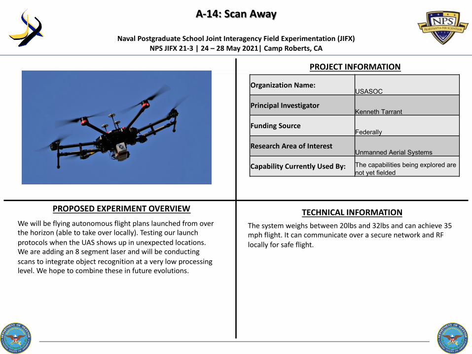
A-14: Scan Away
PROJECT INFORMATION
Naval Postgraduate School Joint Interagency Field Experimentation (JIFX) NPS JIFX 21-3 | 24 – 28 May 2021| Camp Roberts, CA
PROPOSED EXPERIMENT OVERVIEW TECHNICAL INFORMATION
Organization Name:USASOC
Principal InvestigatorKenneth Tarrant
Funding SourceFederally
Research Area of InterestUnmanned Aerial Systems
Capability Currently Used By: The capabilities being explored are not yet fielded
We will be flying autonomous flight plans launched from over the horizon (able to take over locally). Testing our launch protocols when the UAS shows up in unexpected locations. We are adding an 8 segment laser and will be conducting scans to integrate object recognition at a very low processing level. We hope to combine these in future evolutions.
The system weighs between 20lbs and 32lbs and can achieve 35 mph flight. It can communicate over a secure network and RF locally for safe flight.

B-01: Multi-Institutional All Domain C2 for UXS
PROJECT INFORMATION
Naval Postgraduate School Joint Interagency Field Experimentation (JIFX) NPS JIFX 21-3 | 24 – 28 May 2021| Camp Roberts, CA
PROPOSED EXPERIMENT OVERVIEW TECHNICAL INFORMATION
AFRL COPERS system is the foundation for this experiment but there will be a variety of UXS around the globe participating.
Simultaneous Multi-Institutional, Multi-Domain COP Experiment• Led by NPS and AFRL using the AFRL COPERs System• Experiment will integrate position and activity information from
multiple UxS platforms operated by different institutions (academic, government, and industry) into a shared Common Operational Picture system over globally significant distances
Objectives:• Explore simultaneous input and display from multiple UxS/sensor
nodes to a common COP viewed in a COCOM HQ environment.• Identify barriers to information sharing related to the control and
integrated situational awareness of multiple UXS systems owned by different institutions in multiple environments
Organization Name: Naval Postgraduate School
Principal Investigator Dr. Raymond Buettner
Funding Source Federally
Research Area of InterestUnmanned Systems (UxS) Design, Deployment, Operation, Networking and Control
Capability Currently Used By:US Military, Government First Responder Organizations (federal, state, or local),Other federal entity (non-military, non-first responder)

B-02: AI for Small Unit Maneuver
PROJECT INFORMATION
Naval Postgraduate School Joint Interagency Field Experimentation (JIFX) NPS JIFX 21-3 | 24 – 28 May 2021| Camp Roberts, CA
PROPOSED EXPERIMENT OVERVIEW TECHNICAL INFORMATION
Software that is hosted on standard end-user devices.Our Common Control Station (CCS) for UxS is at the core of our desired experimentation. We have experimented with earlier versions of this CCS at previous JIFX events and updated versions of this CCS are what we want to test with at 21-3. We have two thrusts we intend to experiment with using this system:1. Apply the changes being developed under a current contract
with NPS/NSW/AFSOC to add 8 more autonomy behaviors to experiment with "stitching" these capabilities together to provide AI for small unit maneuver operations.
2. Experimenting with a new sUAS (Ascent Spirit) dual coax and adding the Perch-Stare-Detect-Alert-Track sequence of behaviors.
Organization Name: Autonodyne
Principal Investigator Steve Jacobson
Funding Source Federally
Research Area of InterestUnmanned Systems (UxS) Design, Deployment, Operation, Networking and Control
Capability Currently Used By:
US Military, Government First Responder Organizations (federal, state, or local),Other federal entity (non-military, non-first responder),Private Industry
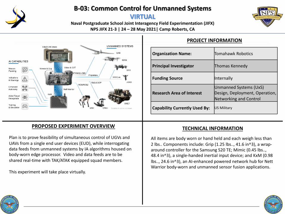
B-03: Common Control for Unmanned SystemsVIRTUAL
PROJECT INFORMATION
Naval Postgraduate School Joint Interagency Field Experimentation (JIFX) NPS JIFX 21-3 | 24 – 28 May 2021| Camp Roberts, CA
PROPOSED EXPERIMENT OVERVIEW TECHNICAL INFORMATION
All items are body worn or hand held and each weigh less than 2 lbs.. Components include: Grip (1.25 lbs.., 41.6 in^3), a wrap-around controller for the Samsung S20 TE; Mimic (0.45 lbs.., 48.4 in^3), a single-handed inertial input device; and KxM (0.98 lbs.., 24.6 in^3), an AI-enhanced powered network hub for NettWarrior body-worn and unmanned sensor fusion applications.
Plan is to prove feasibility of simultaneous control of UGVs and UAVs from a single end user devices (EUD), while interrogating data feeds from unmanned systems by IA algorithms housed on body-worn edge processor. Video and data feeds are to be shared real-time with TAK/ATAK equipped squad members.
This experiment will take place virtually.
Organization Name: Tomahawk Robotics
Principal Investigator Thomas Kennedy
Funding Source Internally
Research Area of InterestUnmanned Systems (UxS) Design, Deployment, Operation, Networking and Control
Capability Currently Used By: US Military

B-04: Vermeer: Augmented Reality UAS Mission planning
PROJECT INFORMATION
Naval Postgraduate School Joint Interagency Field Experimentation (JIFX) NPS JIFX 21-3 | 24 – 28 May 2021| Camp Roberts, CA
PROPOSED EXPERIMENT OVERVIEW TECHNICAL INFORMATION
Vermeer is being experimented via an iOS app being demonstrated with an Apple iPhone X or later as well as an MR headset application utilizing a Microsoft HoloLens 2 with target hardware being commercial off the shelf drone system Freefly systems ASTRO sUAS max takeoff weight (MTOW) of 8.4 kgs
1. Experiment using drones in austere environments to fly in real time the route described by the USG representative within legal FAA guidelines. Objective: Conduct a field usability experiment with USG members to interact and access the Vermeer's proof-of-concept prototype with military end-users, leaders, and customers.
2. Experiment in Automatic Target Recognition. Objective: Conduct a field usability experiment with USG members to assess the viability of post processed Target recognition from Full Motion Video (FMV).
Organization Name: Aerocine Ventures Inc.
Principal Investigator Brian Streem
Funding Source Federally
Research Area of InterestUnmanned Systems (UxS) Design, Deployment, Operation, Networking and Control
Capability Currently Used By: Private Industry, The capabilities being explored are not yet fielded

B-05: Baton – A Precision Delivery System
PROJECT INFORMATION
Naval Postgraduate School Joint Interagency Field Experimentation (JIFX) NPS JIFX 21-3 | 24 – 28 May 2021| Camp Roberts, CA
PROPOSED EXPERIMENT OVERVIEW TECHNICAL INFORMATION
Organization Name:
Principal Investigator
Funding Source
Research Area of Interest
Capability Currently Used By:
Baton:• Weight: 4 to 10 pounds• Diameter of fuselage: 3.75
inches• Height of Fuselage: 14 to 24
inches• Rotor Diameter: 12 inches• Power: 800 Watts Total
(Two 400 watts motors)• Battery: 11.1 volts at 3700
mAh
Organization Name: Applewhite Aero, LLC
Principal Investigator Paul Applewhite
Funding Source Internally
Research Area of InterestUnmanned Systems (UxS) Design, Deployment, Operation, Networking and Control.
Capability Currently Used By: The capabilities being explored are not yet fielded
Precision Descent: Using a manned aircraft, the Baton will be dropped from a variety of altitudes and at different speeds. The Baton will be carried into theater using the unmanned Milo fixed-wing aircraft. The Baton will be dropped simultaneously and individually from the Milo UAS underwing rail.
Array Formation: Using a manned aircraft, 4 to 8 Batons will be landed to form an array. Communications will be established with the array to monitor a variable (e.g. sound, CO2 levels, video). Performance will be measured based on the ability to establish and maintain communications with the array, the robustness of the communications link, and the longevity of the sensor array.
Milo:• Electrically Powered, Tractor
Propeller, PixHawk Cube AutoPilot
• Wing Span: 131 in (3.3 m)• Wing Area: 1350 sq. in (.87 m2) • Length: 73 in (1.8 m)• Empty Weight: 19 lbs.. (6 kg)• Payload: Up to 5 lbs.. (2 kg)• Endurance: 3 hrs. (with 5 lbs..
payload) Optimal Flight Speed: 32 kts (60 km/hrs.)
• Payload Bay: 5 x 4 x 13 (W x H x L in) (12 x 10 x 33 cm)

PROJECT INFORMATION
Naval Postgraduate School Joint Interagency Field Experimentation (JIFX) NPS JIFX 21-3 | 24 – 28 May 2021| Camp Roberts, CA
PROPOSED EXPERIMENT OVERVIEW TECHNICAL INFORMATION
Organization Name:
Principal Investigator
Funding Source
Research Area of Interest
Capability Currently Used By:
Organization Name: VRR (dba VR Robotics & VR Rehab)
Principal InvestigatorKevin Hernandez
Funding Source
Research Area of InterestUnmanned Systems (UxS) Design, Deployment, Operation, Networking and Control.
Capability Currently Used By:US Military
One of VRR’s OSD requirements is to condense the current 3 days of training to fly Indagos down to one. Therefore, VRR plans to measure the actual training times and performance at relevant environments around McMillan and the CACTF, using the latest FAR/SV visualizations including the 'Gunsight' 3D Splash Zone, and 'Instant SA' Data Collection Plan, with the addition of training to competence criteria with our built-in mission rehearsal simulation and the actual drones.
As an option, VRR intends to use their E/W payload and a custom-built drone with ISR defensive capabilities to do RF scans on relevant areas and automatically generate an RF heatmap displayed on their FAR-UI software in real-time.
FAR-UI support of 80+ different types of COTS and GOTS UAS and UGVs. It runs on COTS smartphones, tablets, laptops, and Augmented Reality Helmet Mounted Displays (AR-HMDs) with see-through such as HoloLens 1 & 2, and video see-through such as ZED-Minis combined with Vive or Oculus VR-HMDs. Its key innovation is to use existing common controller software as ‘Middleware’ and then use our better UI while exploiting the underlying COTS or GOTS common controller software.
VRR’s latest version of FAR-UI will be tested with the latest version of VRR’s Common Controller Bridge running on a laptop with telemetry radios to control an Indago 3 or multiple types of MAVlink UASs including VRR custom drones. One system each will be dedicated JFO and JTAC demo and hands-on use stations.
B-08: Control of small UASs with Integration of Fused Augmented Realities (FAR), Intel/Surveillance/Reconnaissance (ISR) & Call For Fire (CFF) VIRTUAL

B-09: HellHive™ UAS Swarm DeploymentVIRTUAL
PROJECT INFORMATION
Naval Postgraduate School Joint Interagency Field Experimentation (JIFX) NPS JIFX 21-3 | 24 – 28 May 2021| Camp Roberts, CA
PROPOSED EXPERIMENT OVERVIEW TECHNICAL INFORMATION
Organization Name:
Principal Investigator
Funding Source
Research Area of Interest
Capability Currently Used By:
Organization Name: VRR (dba VR Robotics & VR Rehab)
Principal InvestigatorKevin Hernandez
Funding Source
Research Area of InterestUnmanned Systems (UxS) Design, Deployment, Operation, Networking and Control.
Capability Currently Used By: The capabilities being explored are not yet fielded
The main experimental procedures for VRR’s HellHive™ at JIFX consist of testing new capabilities towards benefiting HADR activities in a relevant environment. The basic operational tasks include:1. HellHive™ deployment with local/remote lid control.2. Swarm launching of at least five drones at a time, supplied by
VRR/ASU and other partner drone manufacturers. 3. Each UAS must carry a payload of 2.08lb (0.94kg) at
approximately 50mph.4. Each UAS must travel 2km total distance (does not need to
return) from point A to point B.5. Each UAS must land at point B.
HellHive™ does a direct deployment of COTS UAS from an inexpensive COTS Shipping/Storage Box modified with added HellHive™ base and dual launch rods per ‘stack’ of UASs. Each UAS has added to it, dual launch ‘lug’ guides. (evolution of the model rocketry launch rod with lugs on the rocket methods)
VRR’s HellHive™ reuse and retrofit existing containers (mil and commercial) to protect, transport, deploy, and recover swarms of UxS. HellHives™ are completely scalable from small stacks of five UxS in a UPS small box, to 50 UxS in a pickup truck rear deployable configuration (ten honeycomb tubes each with a five stack of UAS).

B-10: Data Strategy for Unmanned Systems
PROJECT INFORMATION
Naval Postgraduate School Joint Interagency Field Experimentation (JIFX) NPS JIFX 21-3 | 24 – 28 May 2021| Camp Roberts, CA
PROPOSED EXPERIMENT OVERVIEW TECHNICAL INFORMATION
Organization Name:
Principal Investigator
Funding Source
Research Area of Interest
Capability Currently Used By:
Organization Name:Naval Postgraduate School
Principal InvestigatorDon Brutzman
Funding SourceFederally
Research Area of InterestUnmanned Systems (UxS) Design, Deployment, Operation, Networking and Control.
Capability Currently Used By: The capabilities being explored are not yet fielded
Our team is implementing a Data Strategy for Unmanned Systems that includes a toolchain for open-source open-standards data collection, archiving and replay. This work builds on prior CRUSER efforts in the Robodata project. We are initially inspecting ScanEagle data and are looking at long-term repeatable patterns for future field experiments.
This necessary capability may enable an even-larger context, namely a Data Strategy for Unmanned Systems field experimentation (FX), modeling and simulation (M&S) supporting Live-Virtual-Constructive (LVC) synthesis, data repositories, and repeatable analysis. A full end-to-end toolchain built using open capabilities has the potential to address these important needs.

D-02: Terrestrial Point-to-Point 100 Gbps Optical Communication
PROJECT INFORMATION
Naval Postgraduate School Joint Interagency Field Experimentation (JIFX) NPS JIFX 21-3 | 24 – 28 May 2021| Camp Roberts, CA
PROPOSED EXPERIMENT OVERVIEW TECHNICAL INFORMATION
The BridgeComm lasercomm terminal is designed for 100 Gbps front haul/backhaul data streams over distances of up to 10 km. The terminals are less than 15 lbs.. weight and draw less than 150W of power. The design of the terminal features an optical system that separates the receive and transmit optics without complex polarization separation. It allows for growth to longer link distances and multiple optical frequencies in the telecommunications C-Band (1550nm).
BridgeComm proposes to test a high capacity 100 Gbps, highly secure (LPi/LPd/AJ), laser communications system between two nodes at distances of up to 3 kilometers apart. BridgeComm will test performance of simultaneous send/receive between the nodes with input from external sources such as radio (e.g. Silvus 4200/4400), video, sensors, and other devices with ethernet connection.
Organization Name: BridgeComm, Inc.
Principal Investigator Joseph Campagna
Funding Source Internally
Research Area of Interest Communication and Networking
Capability Currently Used By: The capabilities being explored are not yet fielded

D-03: Tactical Surveillance and Intelligence Automation at the Edge
PROJECT INFORMATION
Naval Postgraduate School Joint Interagency Field Experimentation (JIFX) NPS JIFX 21-3 | 24 – 28 May 2021| Camp Roberts, CA
PROPOSED EXPERIMENT OVERVIEW TECHNICAL INFORMATION
Organization Name:
Principal Investigator
Funding Source
Research Area of Interest
Capability Currently Used By:
Organization Name: Gantz-Mountain Intelligence Automation Systems Inc.
Principal InvestigatorGreg Wilson
Funding SourceInternally
Research Area of Interest Intelligence, Surveillance, and Reconnaissance (ISR)
Capability Currently Used By:US Military, Government First Responder Organizations (federal, state, or local)
We are looking to experiment with our expeditionary smart tactical ground intelligence automation system which will include automated object detection and classification (persons and vehicles) at-the-edge at multi-kilometer ranges using both long-range day and thermal cameras.1) Experiment to determine automated object detection capability at multi-kilometer ranges using both long-range day and thermal cameras2) Experiment to determine automated object classification (persons and vehicles) capability at multi-kilometer ranges using both long-range day and thermal cameras3) Experiment to determine weapons detection ranges (simulated AK and RPG) using both long-range day and thermal cameras
- Multi-Mission Autonomous Tactical Surveillance System with Artificial Intelligence-at-the-edge
- System fits in a small ruggedized pelican case/LR-ISN Weight –approx. 12lbs
- Right SWAP for tactical applications- Muti-path communications backhaul w/WinTAK Plug-in
- Expeditionary Ruggedized Packaging (IP 67) Size: 10.8 x 9.2 x 4.7 inches

D-04: Integration of Fused Augmented Realities (FAR), Intel/Surveillance/Reconnaissance (ISR) & Call For Fire (CFF) into a Mixed-Reality (MR) Visual Augmentation System
VIRTUAL
PROJECT INFORMATION
Naval Postgraduate School Joint Interagency Field Experimentation (JIFX) NPS JIFX 21-3 | 24 – 28 May 2021| Camp Roberts, CA
PROPOSED EXPERIMENT OVERVIEW TECHNICAL INFORMATION
Organization Name: VRR (dba VR Robotics & VR Rehab)
Principal InvestigatorKevin Hernandez
Funding Source
Research Area of Interest Intelligence, Surveillance, and Reconnaissance (ISR)
Capability Currently Used By:US Military
Dismounted Warfighter ISR & Call For Fire using the latest FAR/SV visualizations recently evolved directly from Ft. Sill feedback towards improving VRR’s 'Gunsight' 3D Splash Zone, and 'Instant SA'. The study will be hands-on use by JIFX available warfighters and white cell members. Data Collection Plan -- FAR-UI records everything and with the participants' permission, includes the collection of audio as they perform the experimental scenarios.
Recent improvements in FAR-UI’s Ground Forces Mode will be tested at relevant environments with different slopes/landscapes around McMillan and within the developed areas of the CACTF. The objective is to validate FAR-UI’s auto-populated maps, map editing on-site in real-time, its Synthetic Vision view with AR graphics, as well as ISR and CFF capabilities at the platoon level.
VRR’s FAR-UI will be tested in Ground Forces Mode and deployed mainly on an MR device (HoloLens 2) which provides optical see-through, allowing visualizations to be seen directly on real-world terrain. It replaces the skybox of FAR-UI with a live camera feed which can be aligned with the synthetic terrain based on telemetry information acquired in the HoloLens2.

E-01: Behavioral Observations Logging Toolkit (BOLT)
PROJECT INFORMATION
Naval Postgraduate School Joint Interagency Field Experimentation (JIFX) NPS JIFX 21-3 | 24 – 28 May 2021| Camp Roberts, CA
PROPOSED EXPERIMENT OVERVIEW TECHNICAL INFORMATION
The software can run on a windows based tablet or on a windows laptop.
The Behavioral Observations Logging Toolkit (BOLT) assists data collectors and analysts by digitally collecting information at the edge of the human-machine interface. We are proposing that BOLT is used to support the data collection for the JIFX White Cell. We intend to coordinate with the JIFX planning team to determine if our tool will enhance the current NPS observation & data collection process.
Organization Name:U.S. Army CCDC Data & Analysis Center Aberdeen Proving Ground, MD
Principal Investigator Norbou Buchler
Funding Source Federally
Research Area of Interest Cyber, Cyber Security, and Electronic Warfare
Capability Currently Used By: US Military

F-02: Cyber Unattended Ground Sensors
PROJECT INFORMATION
Naval Postgraduate School Joint Interagency Field Experimentation (JIFX) NPS JIFX 21-3 | 24 – 28 May 2021| Camp Roberts, CA
PROPOSED EXPERIMENT OVERVIEW TECHNICAL INFORMATION
Organization Name:Innovative Algorithms
Principal InvestigatorJay Chesnut
Funding SourceInternally
Research Area of InterestSituation Awareness
Capability Currently Used By:US Military, Private Industry
Deploy sensors in various areas/terrain and monitor their situational awareness contacts via UI and ATAK. All data is collected automatically via the gateway and UI and stored in a SQLite database. The track data of targets will be gathered automatically via ATAK devices. In house experiments validate a high fidelity play back of sensor hits for ground truth reporting.
Q5 - 4" x 2" x 3.2" - less than 1 pound
Gateway - 3.5" x 5" x 2.5" - less than 2 pounds
X7 - hockey puck size - less than 0.5 pounds
Android phone or tablet
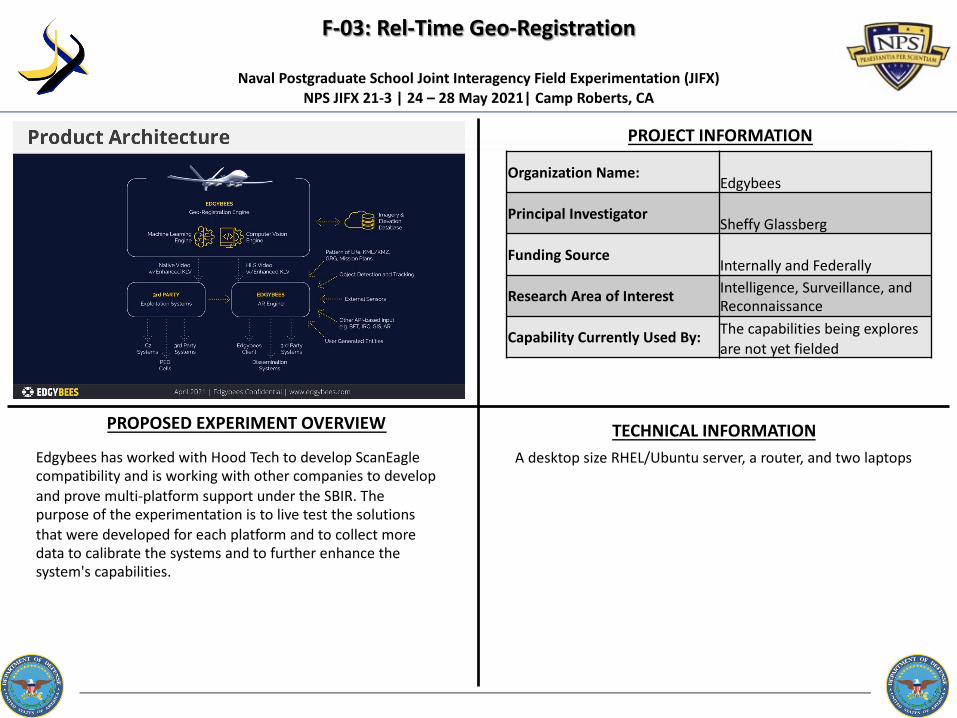
F-03: Rel-Time Geo-Registration
PROJECT INFORMATION
Naval Postgraduate School Joint Interagency Field Experimentation (JIFX) NPS JIFX 21-3 | 24 – 28 May 2021| Camp Roberts, CA
PROPOSED EXPERIMENT OVERVIEW TECHNICAL INFORMATION
Organization Name:Edgybees
Principal InvestigatorSheffy Glassberg
Funding SourceInternally and Federally
Research Area of Interest Intelligence, Surveillance, and Reconnaissance
Capability Currently Used By: The capabilities being explores are not yet fielded
Edgybees has worked with Hood Tech to develop ScanEagle compatibility and is working with other companies to develop and prove multi-platform support under the SBIR. The purpose of the experimentation is to live test the solutions that were developed for each platform and to collect more data to calibrate the systems and to further enhance the system's capabilities.
A desktop size RHEL/Ubuntu server, a router, and two laptops

F-04: ISR and Target Vehicle Inspection Utilizing Autonomous SurfaceVehicle
PROJECT INFORMATION
Naval Postgraduate School Joint Interagency Field Experimentation (JIFX) NPS JIFX 21-3 | 24 – 28 May 2021| Camp Roberts, CA
PROPOSED EXPERIMENT OVERVIEW TECHNICAL INFORMATION
Organization Name: SeaSats
Principal Investigator Mike Flanigan
Funding Source Internally
Research Area of Interest Intelligence, Surveillance, and Reconnaissance
Capability Currently Used By: The capabilities being explores are not yet fielded
The USV for this experiment is 9 feet long, weighs less than 150 lbs, has a single point lift and can be bow towed or launched with two people from a ship. Max speed is 5 knots.Seasats USVs serve as sensor platforms for remote sensing in commercial and defense applications. The propulsion and payload power for the USVs is provided by solar and stored battery power. The vehicles were designed to solve launch and recovery logistics of existing USV platforms by reducing the associated labor and ship hours of those operations by up to an order of magnitude. Along with simple and efficient launch and recovery operations the vehicles are designed to withstand persistent missions for up to 6 months at sea.
For this experiment the vehicle’s remote sensing, improved control authority and navigation, and C2 capabilities will be used to test and explore vehicle inspection applications. A rapidly deployable Seasats unmanned surface vehicle with persistent ISR capabilities detects, or is directed to investigate, a target vessel of interest. The navigates autonomously to the target vessel, enters a tight inspection mode performing visual and radiation signature detection in close proximity to the vessel, while relaying data back to a command center.Key experimental capabilities:
- Navigate in tight proximity to a target vessel- Relay relevant ISR data from the target to command center. - Data quantifying the experimental goals and outcomes
recorded on board the USV & in control center server including nav logs & collected ISR data.

G-01: Intelligent Human Motion (IHM) Trials
PROJECT INFORMATION
Naval Postgraduate School Joint Interagency Field Experimentation (JIFX) NPS JIFX 21-3 | 24 – 28 May 2021| Camp Roberts, CA
PROPOSED EXPERIMENT OVERVIEW TECHNICAL INFORMATION
Exoskeleton human worn equipment. 25 lbs.. Human mounted sensors, small hand held size.
This experiment will test Yotta Navigation's IHM positioning system for indoor and subterranean operations where GPS is limited or not available. The goal of the experiment is to improve accuracy and duration of GPS denied positioning in mock military operational environments. This experimental data will assist the research and development in several DoD SBIR contracts. The goal is for improved situational awareness for soldiers and leaders. Sensor data collections and testing will be conducted in the training buildings and underground tunnels at Camp Roberts.
Organization Name: Yotta Navigation Corporation
Principal Investigator Andrew Hazlett
Funding Source Federally
Research Area of Interest Situational Awareness
Capability Currently Used By: US Military

J-01: AI/ML Enabled High Performance Compute Data Center at theTactical Edge
PROJECT INFORMATION
Naval Postgraduate School Joint Interagency Field Experimentation (JIFX) NPS JIFX 21-3 | 24 – 28 May 2021| Camp Roberts, CA
PROPOSED EXPERIMENT OVERVIEW TECHNICAL INFORMATION
Size: 3' wide x 5' 8" long x 7' high mounted on a vehicle delivered by TMGcoreWeight: 2,200lbsPower 4.5kW TMGcore will bring a 12.5kW generator
TMGcore will demonstrate its capability to enable high performance computing at the Tactical Edge on a portable data center delivering compute capabilities normally only possible in a large-scale data center or data center PODs. Fully self-contained the platform will increase resiliency, eliminate latency, and reduce bottlenecks resulting in the ability to deliver more timely and accurate information to the warfighter at the edge.TMGcore will physically bring a truck with a mobile Edgebox 4.5 installed with network capability provided by a partner with the intent of demonstrating the viability of this technology to perform high performance compute (AI/ML) at the tactical edge.
Organization Name: TMGcore LLC
Principal Investigator Seamus Egan
Funding Source Internally
Research Area of Interest Expeditionary Operations
Capability Currently Used By: Private Industry, The capabilities being explored are not yet fielded

L-01: UAV-UGV Cargo Drop
PROJECT INFORMATION
Naval Postgraduate School Joint Interagency Field Experimentation (JIFX) NPS JIFX 21-3 | 24 – 28 May 2021| Camp Roberts, CA
PROPOSED EXPERIMENT OVERVIEW TECHNICAL INFORMATION
UAV Cargo Dropper weighs 60 grams & can carry 100lbs.Combat operator can (1) minimize time required to resupply & (2) maximize distance between Forward Support Company & theatre. The final product will demonstrate a soldier receiving emergency resupply without leaving his position.
Organization Name: DropDrone
Principal Investigator Daniel Campbell
Funding Source Internally
Research Area of Interest Mobility and Transportation
Capability Currently Used By: The capabilities being explored are not yet fielded
1. Soldier requests emergency resupply2. UGV navigates from soldier position to cargo retrieval location3. UAV navigates from Forward Support Company to cargo retrieval location4. UGV Cargo Retriever actuates5. UAV Cargo Dropper actuates6. UAV flies back to Forward Support Company7. UGV fulfills last leg of delivery from cargo retrieval location to soldier position.

CANCELLEDA-10: Autonomous Wildfire Detection and Suppression with Deep Learning
PROJECT INFORMATION
Naval Postgraduate School Joint Interagency Field Experimentation (JIFX) NPS JIFX 21-3 | 24 – 28 May 2021| Camp Roberts, CA
PROPOSED EXPERIMENT OVERVIEW TECHNICAL INFORMATION
L3Harris Latitude FVR-90 VTOL Fixed Wing UAS- 16' wingspan / 9' length- MGTOW: 120 lb.- Endurance: 14-16 hours (as equipped)- Speed: 42 knots (loiter) | 65 knots (dash)Overwatch Aero Ground Control Station- Redundant command and control links (900 MHz and 2.4 GHz)- Real-time product dissemination- Ground processing of UAS imageryFire Prediction- FlameMapper proprietary fire modeling software with integrated machine learning algorithms
This experiment will test multiple objectives:(1) Autonomous operations of multiple long-endurance VTOL fixed wing UASs(2) Autonomous fire detection using artificial intelligence(3) Dissemination of fire location through ATAK(4) Predictive modeling(5) Fire Suppression Deployment
Organization Name: Overwatch Aero
Principal Investigator Jeff Strebler
Funding Source
Research Area of Interest Unmanned Aerial Systems
Capability Currently Used By:Government First Responder Organizations (federal, state, or local), Non-profits / NGOs / IGOs / INGOs

CANCELLEDA-11: CACTF Tunnel Flights
PROJECT INFORMATION
Naval Postgraduate School Joint Interagency Field Experimentation (JIFX) NPS JIFX 21-3 | 24 – 28 May 2021| Camp Roberts, CA
PROPOSED EXPERIMENT OVERVIEW TECHNICAL INFORMATION
Organization Name: Special Technologies Lab - Nevada National Security Site
Principal InvestigatorRusty Trainham
Funding Source
Research Area of InterestUnmanned Aerial Systems
Capability Currently Used By: The capabilities being explored are not yet fielded
The UAS will be launched at the CACTF site of Camp Roberts, and it will enter the hillside entrance of the underground tunnel. The UAS will autonomously navigate the tunnel and collect visual, inertial, and lidar data as flies its course. In addition, it will collect data from a MiCS-5524 surface catalysis chemical sensor and from a Kromek CZT gamma radiation detector. All data will be time stamped in list mode format and stored locally on the aircraft's on-board computer. Some data will also be radioed back to ground control in real time. Communications with the UAS from ground control will probably break down once the UAS is well within the tunnel. Consequently, the UAS will be fully autonomous throughout the flight.
The UAS is a Gagarin Flyability hexacopter which has a tip to tip diameter of 0.55 meters, and it weighs 3.2 kg. It is powered by a 5S LiPo battery and has a flight time of 8 minutes.
Radio communications are over 2.4 GHz and 5GHz Wi-Fi.
The Lidar is an Ouster OS1 360 degree scanner with a 45 degree vertical field of view. It comprises a class 1M laser with a wavelength of 850nm.

CANCELLEDB-07: Long Range Flight Test w/Group 2 or 3 UAS
PROJECT INFORMATION
Naval Postgraduate School Joint Interagency Field Experimentation (JIFX) NPS JIFX 21-3 | 24 – 28 May 2021| Camp Roberts, CA
PROPOSED EXPERIMENT OVERVIEW TECHNICAL INFORMATION
Organization Name:
Principal Investigator
Funding Source
Research Area of Interest
Capability Currently Used By:
Organization Name:T-Rex Tracking Corporation
Principal InvestigatorMichael Faherty
Funding Source
Research Area of InterestUnmanned Systems (UxS) Design, Deployment, Operation, Networking and Control.
Capability Currently Used By:Government First Responder Organizations (federal, state, or local)
The ideal experiment would be to integrate our tracking system with a Group 2 or 3 UAS and conduct long range flight testing while gathering data at certain ranges and compare that data to the current military data available
Size & Weight: 7 ft tall, 6 ft radius, 200 pounds (fully loaded with multiple high-gain antennas)Tracking Precision:T-Rex Tracker supports larger, higher gain antennas which have tighter beam-width. If a tracking antenna is not precise enough and accurate enough at all times, then the radio link will be broken resulting in lost data packets, video dropouts, and lost command and control links. Tracking Source Data:The T-Rex tracker utilizes either the GPS position of the object being tracked to be provided over Ethernet in a standard, NMEA 0183 format, or it can use its built-in ADS-B receiver to detect the ADS-B out (1090 and 978 MHz) with the aircraft’s GPS position.

CANCELLEDF-01: Crisis Assured Communications, ISR in 4K
PROJECT INFORMATION
Naval Postgraduate School Joint Interagency Field Experimentation (JIFX) NPS JIFX 21-3 | 24 – 28 May 2021| Camp Roberts, CA
PROPOSED EXPERIMENT OVERVIEW TECHNICAL INFORMATION
Organization Name:
Principal Investigator
Funding Source
Research Area of Interest
Capability Currently Used By:
Organization Name:CYTTA Corp.
Principal InvestigatorMichael Collins
Funding SourceInternally
Research Area of InterestSituation Awareness
Capability Currently Used By:US Military, Government First Responder Organizations (federal, state, or local)
Our experiment will be to build a network that will operate securely in any environment and provide clear ISR for a real time situational awareness. We plan to measure bit rate versus packet sizes along with novel improvements to the radios that address attenuated links even in noisy environments. The end result is to see how well our codec and IPTV server works with a, global in scale, mesh network DOD can buy off the shelf. We intend for JVAB to perform tests needed to prove the level of security taught via our proprietary video stream. We will look to NPS and JIFX participants for help in determining how best to stress the network to determine if we will in fact still provide situational awareness/ISR after a catastrophic event.
We plan to deploy a Silvus radio with a battery operated CYTTA appliance to capture video and provide ports for head sets and or mic/speaker. Any donor radio could be added for additional coms configs. This config is 10 lbs.. plus the radio. We can capture several EO/IR sensors up to 4K resolution. If additional sensors are needed we have a 10oz 12v version for static or unattended sensors. We will provide connectivity via self healing mesh network to FOB, McMillan airfield and CACTF. From McMillan airfield we will uplink via Sat link and provide reach back to NPS command center. Our video stream is proprietary with AES 256 built in. Our VPN server is hosted by AWS Gov to achieve an additional level 2 encryption so that not even quantum computers can hack into our proprietary stream.
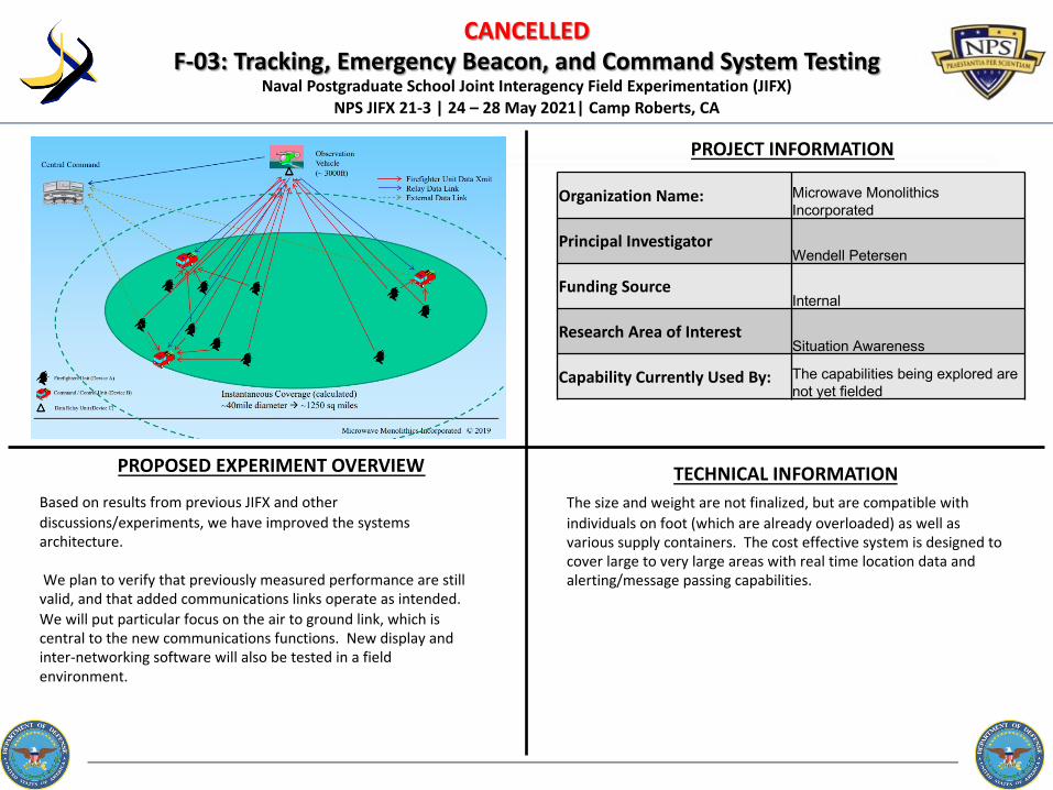
CANCELLEDF-03: Tracking, Emergency Beacon, and Command System Testing
PROJECT INFORMATION
Naval Postgraduate School Joint Interagency Field Experimentation (JIFX) NPS JIFX 21-3 | 24 – 28 May 2021| Camp Roberts, CA
PROPOSED EXPERIMENT OVERVIEW TECHNICAL INFORMATION
Organization Name: Microwave Monolithics Incorporated
Principal InvestigatorWendell Petersen
Funding SourceInternal
Research Area of InterestSituation Awareness
Capability Currently Used By: The capabilities being explored are not yet fielded
Based on results from previous JIFX and other discussions/experiments, we have improved the systems architecture.
We plan to verify that previously measured performance are still valid, and that added communications links operate as intended. We will put particular focus on the air to ground link, which is central to the new communications functions. New display and inter-networking software will also be tested in a field environment.
The size and weight are not finalized, but are compatible with individuals on foot (which are already overloaded) as well as various supply containers. The cost effective system is designed to cover large to very large areas with real time location data and alerting/message passing capabilities.

CANCELLEDH-01: Building Interior Mapping/Modeling for STE-CFT
PROJECT INFORMATION
Naval Postgraduate School Joint Interagency Field Experimentation (JIFX) NPS JIFX 21-3 | 24 – 28 May 2021| Camp Roberts, CA
PROPOSED EXPERIMENT OVERVIEW TECHNICAL INFORMATION
Organization Name:
Principal Investigator
Funding Source
Research Area of Interest
Capability Currently Used By:
Organization Name:US Army Corps of Engineers -Engineer Research & Development Center
Principal InvestigatorRich Curran
Funding SourceFederally
Research Area of InterestOther
Capability Currently Used By:US Military, Other federal entity (non-military, non-first responder), Private Industry
ERDC will be conducting sensor comparison experimentation to compare the data collection to derived 3D products coming from building interior mapping sensor systems.
To accomplish this objective, ERDC is requesting access to the CACTF to scan the entire facility with survey grade sensor systems to generate a baseline reference dataset to compare the interior mapping systems against. During JIFX 20-1, we generated a reference dataset for the CACTF Hotel and a portion of the exterior. We intend to build upon the work previously completed to generate a complete reference dataset of the entire CACTF that will enable objective and quantitative assessments of new/emerging interior mapping technology.
ERDC will need to use various sensor systems to include: • Leica P50 scanner (27.0 lbs., 9.4" x 14.1" x 15.6", class 1 laser
scanner) • Leica TCR 1203 Survey Total Station, Leica GS-16 GPS receivers • Leica RTC360 scanner (11.7 lbs., 4.7" x 9.4" x 9.1", class 1 laser
scanner) • Leica BLK2GO handheld scanner (1.7 lbs., 11" x 3.2", class 1 laser
scanner) • Leica BLK360 scanner (2.2 lbs., 6.5" x 3.9", class 1 laser) • Matterport Pro2 Camera (7.6 lbs., 9.0ʺ x 10.25ʺ x 4.33") • Kaarta Contour handheld Scanner (6.13 lbs., 10.5", 4" x 10.5",
class 1 laser scanner)• Ricoh Theta Z 360 degree camera (.4 lbs., 1.89" x 5.2" x 1.17").

PROJECT INFORMATION
Naval Postgraduate School Joint Interagency Field Experimentation (JIFX) NPS JIFX 21-3 | 24 – 28 May 2021| Camp Roberts, CA
PROPOSED EXPERIMENT OVERVIEW TECHNICAL INFORMATION
Organization Name:
Principal Investigator
Funding Source
Research Area of Interest
Capability Currently Used By:
Organization Name: Tactical Electronics & Military Supply, LLC
Principal InvestigatorDrew Rainwater
Funding SourceInternally
Research Area of InterestExpeditionary Operations,
Capability Currently Used By:US Military, Government First Responder Organizations (federal, state, or local), Other federal entity (non-military, non-first responder)
During JIFX 21-1, the Tactical Electronics Tactical Camera Systems Interoperability and Capability Experiment would test the capabilities and interoperability of multiple camera systems used simultaneously and in collaboration with one another by a tactical or special operations team in a simulated operational environment.
1. K9-XR2. Swift Pole Camera3. Swift UDC
Major System Dimensions:- Swift Pole Camera, Collapsed – 3.375” W x 12” L x 2.75” T- Swift Pole Camera, Extended – 3.375” W x 39” L x 2.75” T- UDC – 8.25” L x 1.85” W x 1.10” H with a 0.25”-thick distal end.
CANCELLEDJ-02: Tactical Camera Systems Interoperability and Capability Experimentation
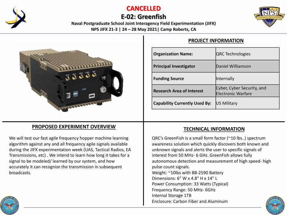
CANCELLEDE-02: Greenfish
PROJECT INFORMATION
Naval Postgraduate School Joint Interagency Field Experimentation (JIFX) NPS JIFX 21-3 | 24 – 28 May 2021| Camp Roberts, CA
PROPOSED EXPERIMENT OVERVIEW TECHNICAL INFORMATION
QRC’s GreenFish is a small form factor (~10 lbs..) spectrum awareness solution which quickly discovers both known and unknown signals and alerts the user to specific signals of interest from 50 MHz- 6 GHz. GreenFish allows fully autonomous detection and measurement of high speed- high pulse count signals. Weight: ~10lbs with BB-2590 BatteryDimensions: 6" W x 4.8" H x 14" LPower Consumption: 33 Watts (Typical)Frequency Range: 50 MHz- 6GHzInternal Storage 1TBEnclosure: Carbon Fiber and Aluminum
We will test our fast agile frequency hopper machine learning algorithm against any and all frequency agile signals available during the JIFX experimentation week (UAS, Tactical Radios, EA Transmissions, etc) . We intend to learn how long it takes for a signal to be modeled/ learned by our system, and how accurately it can recognize the transmission in subsequent broadcasts.
Organization Name: QRC Technologies
Principal Investigator Daniel Williamson
Funding Source Internally
Research Area of Interest Cyber, Cyber Security, and Electronic Warfare
Capability Currently Used By: US Military

D-01: Seamless Integration of HF/VHF/LTE/Satcom for Failover/Fallback Communications CANCELLED
PROJECT INFORMATION
Naval Postgraduate School Joint Interagency Field Experimentation (JIFX) NPS JIFX 21-3 | 24 – 28 May 2021| Camp Roberts, CA
PROPOSED EXPERIMENT OVERVIEW TECHNICAL INFORMATION
This integrated solution contains multiple RF platforms that are interconnected via IP. The following pathways have been integrated to reinforce the idea of scalability: MANET mesh, Private LTE, NIPR, V/UHF (P25), HF (3G ALE, Digital Data & Voice) and SATCOM (Iridium Certus).The key is that each device provides secured voice & data products and TAK integration.MANET Mesh Radio: Domo Tactical Communications (DTC) - SDRPrivate LTE: Applied Technologies Tactical LTENIPR: CradlePoint and Thales Mission Link CertusV/UHF (P25): Icom - base & mobile with TAK integrationHF: Codan combined with custom software from NVIS Communications LLC.SATCOM: Icom with Dark Wolf Ventures Products
Organization Name: NVIS Communications, LLC.
Principal Investigator John Rosica
Funding Source Internally
Research Area of Interest Communication and Networking
Capability Currently Used By:
US Military, Government First Responder Organizations (federal, state, or local),Other federal entity (non-military, non-first responder),Private Industry, Non-profits / NGOs / IGOs / INGOs
NVIS Communications principal goal is to show the efficacy of blending multiple RF pathways (using both COTS and MIL-STD equipment) into a scalable system design that is easy to use.This design will accomplish three goals:1. Act as a gateway for a “bring your own device” paradigm, where foreign military, various; Federal, State & Local entities, and even various military services branches can come together in commonality. This gateway will provide voice, data, limited NIPR network and ATAK data capabilities, locally. As well as multi-pathway, long distance back-haul solution.2. Provide the ability to drop, restrict or remote kill device access when OpSec has been compromised.3. Be seamless and easy to use to the end user so that they may concentrate on the mission and/or task at hand.

CANCELLEDB-06: Persistent Intelligence Surveillance and Reconnaissance (ISR), Communications Relay,
Stand-Off Sensitive Site Exploitation from Tethered Platform
PROJECT INFORMATION
Naval Postgraduate School Joint Interagency Field Experimentation (JIFX) NPS JIFX 21-3 | 24 – 28 May 2021| Camp Roberts, CA
PROPOSED EXPERIMENT OVERVIEW TECHNICAL INFORMATION
Organization Name:
Principal Investigator
Funding Source
Research Area of Interest
Capability Currently Used By:
Organization Name:HoverFly Technology
Principal InvestigatorJeffrey Williams
Funding Source
Research Area of InterestUnmanned Systems (UxS) Design, Deployment, Operation, Networking and Control.
Capability Currently Used By:US Military, Government First Responder Organizations (federal, state, or local), Other federal entity (non-military, non-first responder)]
Experiment with Digital Barriers EdgeVis Live Low to demonstrate plug-and-play encoding technology that improves video quality and reliability when streaming over any variety wireless links, measuring latency and bandwidth savings.
Additional experimentation can include stand off biometrics, measuring distances for facial recognition and electronic warfare, and measuring distance to intercept or capture various SIGINT.
Major System DimensionsTethered UAS 20.5” x 20.5” x 8.5”System 37.5” x 27” x 13.5”With capability to deploy 200’ (60m) tether for greater stand-offTotal Weight 57.5 lbs.Power Requirements >2kW Network Connections Internal Network

TEMPLATE
PROJECT INFORMATION
Naval Postgraduate School Joint Interagency Field Experimentation (JIFX) NPS JIFX 21-3 | 24 – 28 May 2021| Camp Roberts, CA
PROPOSED EXPERIMENT OVERVIEW TECHNICAL INFORMATION
TextText
Organization Name:
Principal Investigator
Funding Source
Research Area of Interest
Capability Currently Used By:

![SRR and NBCSRR Inspired CPW Fed Triple Band Antenna with ... · property, many researches have been done for the performance improvement of the antenna. SRR ... [16], and each SRR](https://img.pdfslide.us/doc/110x75/5e2b868b3c9fad02ba12180e/srr-and-nbcsrr-inspired-cpw-fed-triple-band-antenna-with-property-many-researches.jpg)