Embed Size (px)
Citation preview
9W CORRIDOR STUDY PUBLIC INFORMATIONAL MEETING
March 11, 2008, 6:00 pm Bethlehem Town Hall, Town of Bethlehem, New York
WORKBOOK
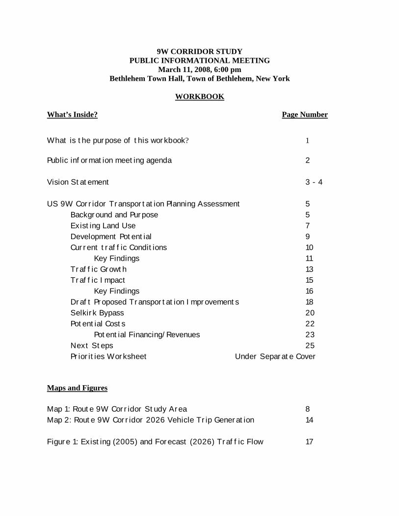
What’s Inside? Page Number
What is the purpose of this workbook? 1
Public information meeting agenda 2 Vision Statement 3 - 4 US 9W Corridor Transportation Planning Assessment 5
Background and Purpose 5 Existing Land Use 7 Development Potential 9 Current traffic Conditions 10 Key Findings 11 Traffic Growth 13 Traffic Impact 15 Key Findings 16 Draft Proposed Transportation Improvements 18 Selkirk Bypass 20 Potential Costs 22
Potential Financing/Revenues 23 Next Steps 25 Priorities Worksheet Under Separate Cover Maps and Figures Map 1: Route 9W Corridor Study Area 8 Map 2: Route 9W Corridor 2026 Vehicle Trip Generation 14 Figure 1: Existing (2005) and Forecast (2026) Traffic Flow 17
What is the purpose of this workbook?
The purpose of this workbook and accompanying prioritization and comment sheet is twofold:
To provide the community and other stakeholders with a summary of key findings from study related technical work, public outreach and Study Advisory Committee recommendations/discussions related to:
• 9W Corridor DRAFT improvement concepts
• Selkirk Bypass options and the preferred alternative.
To receive back from the community and other stakeholders:
• comments on 9W Corridor DRAFT improvement concepts • comments on Selkirk Bypass preferred alternative • comments on relative priority of implementation of 9W Corridor DRAFT
improvements
1

9W CORRIDOR STUDY PUBLIC INFORMATIONAL MEETING
AGENDA
March 11, 2008, 6:00 pm Bethlehem Town Hall, Town of Bethlehem, New York
1. 6:00 Open House
Study team members will be available at four stations to discuss the Draft Rt. 9W Study proposal with Town residents. Stations will be provided for the northern, central and southern sections of the Corridor, and for the Selkirk Bypass.
2. 7:00 Public Presentation of Draft Study Proposals
The study consultants, Wilbur Smith Associates, will provide a power point presentation outlining major study findings, and the draft proposal for transportation improvements and land use actions in the corridor.
3. 7:30 Public Comments and Questions
The study team will take comments and questions on the Rt. 9W Study proposal.
4. 8:30 Resume Open House
5. 9:30 Adjournment
2
VISION STATEMENT GUIDING THE DEVELOPMENT OF A TRANSPORTATION PLAN FOR THE US 9W CORRIDOR
(accepted by the 9W SAC at its January 2008 meeting) The Town of Bethlehem seeks to provide a visually attractive and vibrant corridor for people traveling Route 9W and for those living and working near it. In accordance with the adopted Comprehensive Plan, the Town of Bethlehem intends to establish compact hamlet centers and encourage aesthetically pleasing development in those centers that will be sensitive to the Corridor's unique natural and historic features, while preserving the scenic and pastoral qualities of the rural landscape located between the hamlet centers. Transportation improvements will be designed with all users in mind. Bicycle, pedestrian, and transit connections to neighborhoods, retail areas, and business parks will be an important part of the plan. Transportation improvements will be planned, designed, and constructed in an integrated way according to the following principles:
1. Transportation and circulation systems are important to the town's (and region's) economy and quality of life. A capable transportation system helps assure adequate employment and mobility which in turn supports a healthy tax base. A sound tax base helps the town provide the services that build a quality community.
2. Transportation plans and designs should not focus solely on the automobile. The
Town's Comprehensive Plan and CDTC's New Visions Plan call for designing transportation improvements that promote transit use, walking, and the use of bicycles. The pedestrian environment, for example, should not only include sidewalks, but also safe crossings at all intersections throughout the corridor and linkages between residential neighborhoods and pedestrian generators. Conventional solutions which only increase roadway capacity, often reduce one problem (delay) but exacerbate others (walking environment), particularly if they increase total vehicular travel. When all costs and benefits are considered, an integrated plan that includes an appropriate set of complementary strategies is often the most cost-effective way to improve transportation. Cooperation and collaboration with landowners will be essential to implementation of the plan.
3. Transportation is not only about moving people and goods, but also about creating
attractive and livable communities. One objective of our regional and local plans is to make incremental improvements in the appearance of the town's streetscape in conjunction with transportation improvements (and land development) in order to project a positive image of the community. The planting of trees in the corridor, for example, will not only enhance community beauty but will also help slow traffic, making travel in the corridor safer and more pleasant for residents, cyclists and walkers.
4. Funding is a significant constraint. Building enough road capacity to handle all the
traffic that wants to travel during the peak travel period without delay could be impractical and prohibitively expensive. Management actions can be more helpful in advancing economic development goals of the town because they have been proven to promote more efficient land use and transportation systems. Because competition for
3
federal and state funding is extremely tight and regional needs extensive, public financing through traditional sources will not be possible. Public/private partnerships will be necessary in order to implement the plan. Focusing on operational and management actions, including advanced traffic signal technology, driveway consolidation, shared access, service roads, roundabouts, and other relatively low-cost actions can help make the plan more affordable to both the public and private sectors.
5. Land use planning and day-to-day development decisions have a big role to play in building quality communities and workable transportation systems. Where and how we plan and design the places we work, live, shop and play can significantly affect a community's livability and cohesion. A land use plan that promotes compact development, defines an appealing and coherent image, and emphasizes connected streets, sidewalks and convenient access to transit play a critical role in cultivating a "sense of place" and establishing sustainable economic development opportunities that include but are not limited to new office space, neighborhood stores, quality restaurants, and other services. Designing and building our neighborhoods to foster and accommodate multiple transportation modes that provide options for transportation system users directly influences mobility and accessibility, enhances transportation-land use compatibility and supports achieving the highest quality of life in the best possible environment.
6. Environmental protection is important. The conservation and wise use of the
corridor’s natural resources are fundamental to achieving a habitable and aesthetically pleasing environment. This design planning effort recognizes the benefit of coordinating land and transportation development with sensitive treatment of natural and cultural resources such as wetlands and streams, open space, woodlands, and historic features and will identify transportation and building designs which minimize adverse impacts on natural resources, and which are consistent with and supportive of the town's environmental conservation goals.
4
Advancing the Town of Bethlehem's Comprehensive Plan
US 9W Corridor Transportation Planning Assessment
BACKGROUND AND PURPOSE:
Why was a study commissioned for the US 9W corridor?
The Town of Bethlehem is an attractive and livable community that has experienced a healthy amount of residential and commercial growth over the last sixteen years. Since 1990, more than 2,800 housing units and 1.2 million square feet of commercial and industrial space has been added to the town's tax base. The Town's Route 9W corridor has shared in almost half of the commercial growth, adding 600,000 square feet of commercial and industrial space; residential growth has been more modest relative to the rest of the town, with about 200 new housing units built in the corridor. The Town's Comprehensive Plan, adopted by the Town Board in 2005, specifically identified the Route 9W corridor as an area that can expect to face significant development pressure in the coming years. The Plan sees the corridor well-positioned to take advantage of the expected regional demand for high technology and medical services. The Plan recognizes the need for better integration of new and existing development with a more balanced transportation system.
In response to the Comprehensive Plan's recommendation, the Town of Bethlehem commissioned a planning study of the Route 9W area of the Town with the assistance of the Capital District Transportation Committee (CDTC) and Wilbur Smith Associates. The CDTC is the designated Metropolitan Planning Organization (MPO) carrying out federal requirements for cooperative transportation planning and programming within the metropolitan area surrounding the Albany-Schenectady-Troy urbanized area. Wilbur Smith Associates is the planning consultant for the study. A critical component of the study involves an assessment of the transportation infrastructure's ability to accommodate traffic generated by additional development in this area of the town.
What is the purpose of the US 9W Transportation Assessment?
The transportation assessment presented here is a result of a cooperative planning effort between the Town of Bethlehem and the Capital District Transportation Committee. The Route 9W study will build upon the land use findings and recommendations identified in the Town's Comprehensive Plan, developing a focused and targeted 9W corridor transportation and land use vision and management plan.
5
The 9W study:
1. Reviewed the feasibility of a northern alignment alternative to the Selkirk Bypass project. NYSDOT's project development work for the Selkirk Bypass identified a 'northern alignment' that would mitigate the impact of truck traffic on the hamlet of Selkirk. In accordance with the direction given in the Comprehensive Plan, the town looked at this in the context of a lot more than just a 'Selkirk bypass' by engaging the community in a discussion of the ability of a northern Selkirk Bypass alignment to support the Town's land use and transportation vision for the corridor.
2. Identified transportation and land use actions needed to support planned
development in the corridor. Priority was given to operational and management actions, including advanced traffic signal technology, driveway consolidation, shared access, service roads, roundabouts, and other relatively low-cost actions. Bicycle and pedestrian links to neighborhoods, retail areas, and business parks were identified as well. Building enough road capacity to handle all the traffic that wants to travel during the peak period at the same time without delay was recognized as impractical and prohibitively expensive. Management actions when linked to good land use design can be more helpful in advancing economic development goals of the town because they have been proven to promote more efficient land use and transportation systems.
3. Explored opportunities to improve the look of the roadway and curb appeal of
commercial buildings through streetscaping and refinement of site and urban design guidelines developed in the comprehensive plan. Research has shown that aesthetics plays an important role in the economic success of communities. The Town’s Comprehensive Plan, CDTC's New Visions 2030 Plan, NYSDOT's Transportation Strategies for a New Age: NY's Transportation Plan for 2030, and the State's Quality Communities Initiative all call for designing land use development and transportation projects to support and proactively create vibrant, attractive communities.
4. Developed a financial plan for recommended improvements. Because
competition for federal and state funding is extremely tight and regional needs extensive, public financing through traditional sources cannot be assumed. Public/private sharing of costs of new transportation infrastructure will be key to successful plan implementation. Economic development opportunities that can financially supplement public resources committed to the project through CDTC's Transportation Improvement Program were highlighted.
6
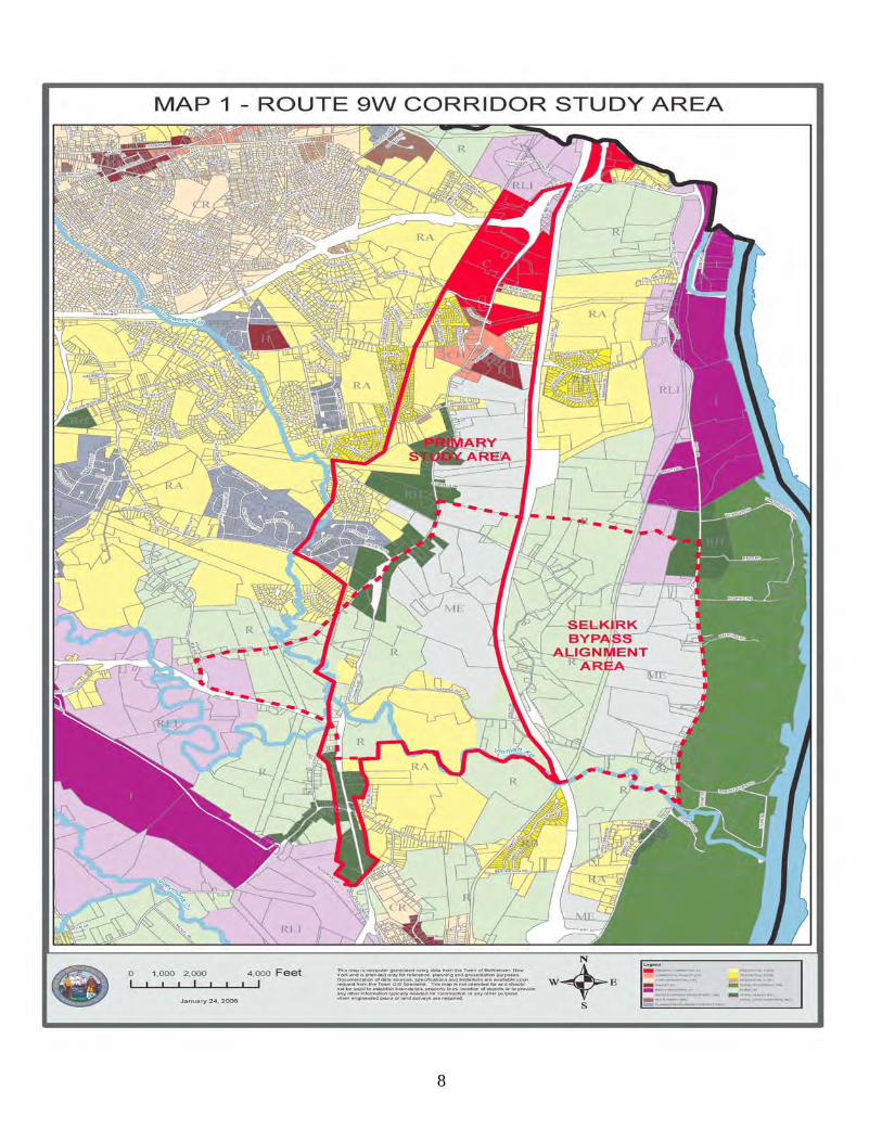
What Area in the Town of Bethlehem is being studied? As shown on Map 1 the study area extends for approximately six miles from Hannay Lane (near the Delmar Bypass) on the north to Cottage Lane, south of NY 396. The width varies up to one mile and is bounded by the NYS Thruway on the east and the utility right-of-way on the west. What are the existing land uses within the 9W Corridor Study Area? Existing land uses along the 9W Corridor include auto-oriented commercial concentrations at the north end centered around various big box stores on the west side of Route 9W. Smaller scale uses are also found and include gas stations, grocery stores, financial institutions, family restaurants, and other retail stores accessible primarily by automobile. The size of commercial uses gradually changes to a smaller scale as one travels south. Here residential uses, both single and multiple family units, begin to be intermixed with commercial uses. The character of the roadway begins to change, with more commercial uses located in former single family residences, the presence of more trees, and fewer parking areas close to the roadway. Near Route 9W's intersection with Wemple Road, land use cover shifts to agricultural or former agricultural fields. South of Wemple Road, the mix of residential and small scale commercial uses resumes, with more older and potentially historic houses close to the road. This general pattern, with some community and public services intermingled, continues almost the entire remaining length of Route 9W in Bethlehem with a mainly residential area in Selkirk and a principally industrial area south of the railroad overpass. 9W Corridor zoning varies significantly from north to south. The northern end is primarily general commercial and light industrial districts, although around Feura Bush Rd. zoning districts include commercial hamlet and hamlet. In the middle section of the corridor mixed economic development, rural hamlet and residential zones predominate. The southern end of the corridor is primarily rural and rural light industrial districts, with some rural hamlet and core residential districts found near Bridge St and Maple Avenue in Selkirk. Commercial and industrial building space in the corridor currently totals more than 2.3 million square feet, an increase of 600,000 square feet since 1990. About 30 percent of the town's commercial and industrial tax base is located in the corridor. About 10 percent of the town's residential tax base is currently found in the corridor, totaling about 1,450 housing units. Roughly 200 housing units were built since 1990 within the 9W Study Area; however, residential development near the corridor was more substantial. What are the land use issues along the corridor and what type of development projects have been proposed? Land use and development patterns along the corridor are auto-oriented for the most part, especially in the corridor’s northern portion. While buffering of larger retail uses from the street in this area has lessened the visual impact from the roadway of the large parking lots and big box
7
8
structures themselves, site layouts here make it difficult to reach destinations by any other means than private motor vehicle. However, the Town’s commitment to access management is evident in this section, reducing the potential number of new driveways and resulting in some cross parcel connections. In other areas, individual residential structures with separate driveways have converted to commercial uses along a strip. This is not necessarily a problem as long as the residential character is maintained with similar low, “residential-like” traffic volumes. In other places, closely spaced higher volume driveways, especially those located in the functional areas of intersections, have led to increasing vehicle to vehicle conflicts and resulting crashes, and erosion of roadway traffic carrying capacity. Many residential uses remain along the corridor. One challenge is to maintain livability of the corridor as traffic volumes and additional development occurs. There are a mix of land uses with various setbacks and architectural styles. Design guidelines would be helpful in fostering the type and form of development desired by the community. Selkirk livability continues to be an issue due to truck traffic relative to residential uses. In general, additional proposed/approved commercial development is found along the northern portion of 9W or the southern Rural Hamlet or Industrial Districts. New residential developments, both proposed and some approved, are located on both sides of Route 9W in the mid-section. DEVELOPMENT POTENTIAL How much and what kind of development can reasonably be expected over the next 20-25 years? Estimates of the type and pace of future development were based on:
consideration of existing uses regional and local industrial, office, and research growth, expected regional demand for high technology and manufacturing service, and the vision for the community expressed in the town's Comprehensive Plan.
Because Route 9W is one of the only areas in Bethlehem zoned for commercial and mixed economic development (MED) use, it is reasonable to assume that a significant proportion of the Town’s future commercial development will occur here. Looking at development trends in the region and in the Town of Bethlehem over the last 15 years, it does not seem plausible to expect full build-out of the corridor by 2026. For this study, it was assumed that the pace of long-term development would occur at a pace comparable to what has taken place in the town during the last 15 years.
9
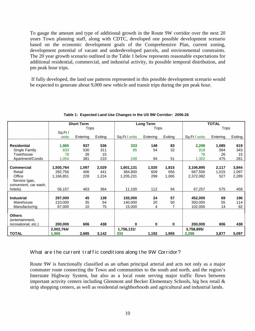
To gauge the amount and type of additional growth in the Route 9W corridor over the next 20 years Town planning staff, along with CDTC, developed one possible development scenario based on the economic development goals of the Comprehensive Plan, current zoning, development potential of vacant and underdeveloped parcels, and environmental constraints. The 20 year growth scenario outlined in the Table 1 below represents reasonable expectations for additional residential, commercial, and industrial activity, its possible temporal distribution, and pm peak hour trips. If fully developed, the land use patterns represented in this possible development scenario would be expected to generate about 9,000 new vehicle and transit trips during the pm peak hour.
Table 1: Expected Land Use Changes in the US 9W Corridor: 2006-26
Short Term Long Term TOTAL Trips Trips Trips
Sq.Ft /
units Entering Exiting Sq.Ft / units Entering Exiting Sq.Ft / units Entering Exiting Residential 1,965 937 536 333 148 83 2,298 1,085 619
Single Family 833 530 311 85 54 32 918 584 343Townhouse 78 26 15 78 26 15Apartment/Condo 1,054 381 210 248 94 51 1,302 475 261
Commercial 1,505,764 1,097 2,029 1,601,131 1,020 1,815 3,106,895 2,117 3,844 Retail 282,756 406 441 384,800 609 656 667,556 1,015 1,097 Office 1,166,851 228 1,224 1,205,231 299 1,065 2,372,082 527 2,289
Service (gas, convenient, car wash, hotels) 56,157 463 364 11,100 112 94 67,257 575 458
Industrial 297,000 45 139 155,000 24 57 452,000 69 196
Warehouse 210,000 35 64 140,000 20 50 350,000 55 114Manufacturing 87,000 10 75 15,000 4 7 102,000 14 82
Others (entertainment, recreational, etc.) 200,000 606 438 0 0 0 200,000 606 438
TOTAL 2,002,764/ 1,965 2,685 3,142
1,756,131/ 333 1,192 1,955
3,758,895/ 2,298 3,877 5,097
What are the current traffic conditions along the 9W Corridor? Route 9W is functionally classified as an urban principal arterial and acts not only as a major commuter route connecting the Town and communities to the south and north, and the region’s Interstate Highway System, but also as a local route serving major traffic flows between important activity centers including Glenmont and Becker Elementary Schools, big box retail & strip shopping centers, as well as residential neighborhoods and agricultural and industrial lands.
10

Within the analysis area, Route 9W is approximately six miles in length with seven signalized intersections. In addition, there are more than two hundred driveways serving residential and commercial establishments along the corridor. Daily traffic volumes along the highway range from approximately 8,000 vehicles per day at the Town’s southern boundary, to approximately 16,000 vehicles per day at the Delmar Bypass (NY 32). Some of the key findings:
Traffic Levels: The number of peak-hour vehicle trips attracted to and produced by development in the study area totaled nearly 5,600 trips in 2006. This represents a 54 percent increase in peak hour trips into the area over 1990 levels of about 3,625 trips. Peak hour traffic growth on Route 9W itself increased between 20 percent near Feura Bush Road and 40 percent near the Delmar Bypass. Traffic levels south of Creble Road changes very little.
Intersections: Intersections along the corridor generally work well, operating at LOS C
or better (“LOS” is a measure of vehicle delay rated from “A” very good to “F” very poor) except for the intersection of Rte 9W with Farm Family/Bender Lane. In addition, while its LOS is acceptable (D or better) the intersection of 9W and Feura Bush Rd/Glenmont Rd has a skewed alignment, creating blocked sight lines and awkward travel movements. Finally, the 9W/Route 32 Jughandle intersection also works fairly well (LOS D or better) during peak travel periods, however while the configuration of this intersection provides convenient access from the Delmar Bypass to Route 9W, the return trip is far less direct.
Mainline: A mainline analysis looked at the physical ability of the road to carry existing
and future traffic volumes without any changes to the roadway system. By comparing mid-block volumes against theoretical mid-block capacities operational deficiencies can be identified. Under existing traffic conditions, the entire corridor operates at about 25 – 50 percent of its practical capacity, with the exception of the segment between Route 32 and Feura Bush Road, which is operating closer to its practical capacity. This means that Route 9W has enough reserve capacity to absorb traffic generated by a modest amount of new development assuming that: driveways are limited and spaced far apart; traffic signals are properly spaced and coordinated; and intersections are properly designed.
Trucks: For decades, State Route 396 has served as a truck route in southern Bethlehem,
providing a link between the Town's industrial areas and the New York State Thruway system. The most heavily traveled section of this road is between Routes 9W and 144, a winding two-mile stretch that runs through the hamlet of Selkirk and functions as its main street. It is the dual functions of Route 396 -- as a major truck route for the industries in the Town and as the main street for the hamlet -- that have become the source of conflict.
Classification counts conducted by NYSDOT indicate that Route 396 through the hamlet of Selkirk carries in excess of 525 trucks per day. This truck traffic accounts for almost 20 percent of the total traffic volume on the roadway. This compared to a seven percent
11
NYSDOT reported average on major State highways in the Capital District. Trucks on Route 9W range between 2-7 percent.
Transit: Public transit is a vital component of a well-rounded community transportation plan.
Transit provides a good alternative to driving, and in some cases is the only reasonable and affordable alternative to getting to work. Transit service along the corridor is limited but very successful. The Capital District Transportation Authority (CDTA) runs bus transit Route 7, a service begun in May 2003 which connects Bethlehem Center and Glenmont with downtown Albany. Bus Rte 7 provides connections to the rest of the CDTA network, including other regional transportation centers such as the Albany International Airport and Rensselaer Train Station. While the total number of transit users may be small compared to the overall number of corridor travelers in automobiles and trucks, for people living within or close to the corridor and for those coming to the businesses or facilities located there, this transit service provides a critical transportation service for those without regular access to an automobile, as well as a non-auto travel choice for others. Use of this route has grown significantly from 4,000 monthly riders in 2003 to more than 18,000 riders today. Transit is a more attractive choice when the walking trip to/from the stop is safe, pleasant and within a reasonable distance.
Property Access: Rte 9W has more than 200 driveways and roadway intersections within
the study area. Excess curb cuts and resulting driveway turn movements create conflicts between through and turning traffic which can interrupt traffic flow. As the number of conflicts increases, congestion and traffic crashes typically follow. This undesirable situation also limits the suitability of arterials for use by pedestrians, transit users, and bicyclists. Where problems exist or are emerging, unchecked construction of new driveways would threaten the operational integrity of the corridor. On the residential side, heavy traffic volumes and through traffic also diminish the quality of residential living environments. It will be necessary for any plan for the Rte 9W Corridor to incorporate access management treatments which can result in fewer crashes and traffic delays due to fewer conflicts between vehicles entering or leaving the roadway, fewer driveways for bicyclists and pedestrians to cross, better overall access to developments because traffic flows more smoothly, decreased roadway costs, and increased capacity per lane of roadway, in addition to other positive effects. Constructing a more complete local road network or service roads, for example, can help build out the street system so that all traffic doesn’t end up using a LOS E or F intersection.
Safety: Crashes that occurred at intersections as well as within midblock segments were
examined over a 3 year period revealing that the corridor overall functions fairly well from a vehicular safety standpoint using traditional measures. Clusters of crashes can be found along the corridor, particularly between Feura Bush Road and Beacon Road where the large number of driveways and turning traffic contributes to a high number of vehicular conflicts and higher crash occurrence. However, due to lack of adequate and safe facilities, walkers, cyclists, and transit users are exposed to greater risk.
Pedestrians: Walkability of the corridor is poor as sidewalks are limited and
intersections are uncomfortable to cross due to a lack of pedestrian signals and
12
crosswalks. The presence or absence of sidewalks and safe, comfortable pedestrian street crossings are an important feature to be noted along the Route 9W corridor. Adequate pedestrian accommodations can link the residential areas to the east and west of the existing commercial areas, link transit stops to surrounding areas, and provide improved overall circulation as a viable alternative to the motor vehicle.
Bicycles: There are no facilities specifically oriented towards bicycle travel in the Route
9W Study Area. The roadway itself has paved shoulders of variable widths that legally can be used by bicyclists. However, the bicycle level of service on Route 9W is marginal for most of its length; relatively high travel speeds, high traffic volumes and the lack of a dedicated bicycle facility contribute significantly to the low ratings along the corridor in both directions.
TRAFFIC GROWTH What is the expected growth in traffic generated by new development in the Town of Bethlehem and in the Route 9W corridor by 2026? Development in the Town of Bethlehem currently generates about 27,400 vehicle trips during the afternoon peak hour. Under 2026 land use conditions (based on the Comprehensive Plan), travel in the town will increase by about 33 percent, generating more than 36,000 vehicle trips. Development in the Route 9W corridor currently accounts for 20 percent of total trip making in the Town, generating about 5,600 vehicle trips during the afternoon peak travel hour. For 2026, the number of peak hour trips generated by development in the study area will more than double, increasing to about 14,700 vehicle trips. The total number of peak hour vehicle trips attracted to and produced by development in the corridor is summarized on Map 2 on the next page. How was traffic demand (trip generation) determined for development in the study area?
The approach to trip generation used in this study consisted of applying a known trip rate derived in part from local traffic and land use data collected by CDTC staff and supplemented by data reported in the seventh edition of the ITE Trip Generation Manual.
13

Map 2
14
TRAFFIC IMPACT
How was traffic impact of new development determined?
CDTC evaluated the impacts of the development growth in the Route 9W corridor using the CDTC STEP Model. The CDTC Systematic Traffic Evaluation and Planning (STEP) Model is a travel demand model which utilizes VISUM software. The simulation of travel is based on the premise that the magnitude and pattern of travel is a stable function of the characteristics of the land use pattern and of the transportation system. In travel simulation modeling, those aspects of land use development and of the regional transportation system demand are identified, quantified, and correlated with travel through the analysis of origin-and-destination, land use, and transportation system data. It has been demonstrated that the relationships between land use and the transportation system and attendant travel remain reasonably stable over time, thus enabling the forecast of future distribution and intensity of land use activity in a corridor and in the surrounding communities as the major factor influencing future traffic patterns, a transportation plan could be developed which would not only serve the existing traffic patterns in the area, but which would also serve the new pattern that will evolve with changing development.
CDTC staff, in consultation with the town planning department, developed a corridor version of CDTC's STEP Model for use in evaluating future traffic conditions in the town of Bethlehem. The Bethlehem version of the STEP model includes 38 traffic analysis zones representing the entire town, including 12 zones within the Route 9W corridor study area. The STEP model generates traffic forecasts for the PM peak hour, generally the critical design period for highway facilities. Calibration of the model involved adjustments to the traffic assignments through corrections to speeds, travel paths, and other model parameters until estimated traffic flow was simulated to actual traffic counts. Figure 1 on the next page shows resulting traffic flows forecast for Years 2005 and 2026.
What is the likely effect on the existing transportation system of traffic growth by 2026?
Using CDTC's STEP model, CDTC staff completed a series of traffic assignments to help assess the overall traffic impact on the 9W corridor for various transportation futures including:
one without a bypass but with no other major changes others with a bypass in different general alignment locations (southern/central/northern)
but with no other major changes different general alignment locations either ending at the Thruway or NY 144 but with no
other major changes. Traffic assignments for each land use future and for each Selkirk alternative were then used by the study consultant, Wilbur Smith Associates (WSA) to conduct highway capacity analysis and
15

ultimately to develop the draft improvements proposed for the 9W corridor itself that are being reviewed and discussed at this public workshop. Some of the key findings: As land use development continues, potentially producing 9,000 new vehicle and transit trips during the pm peak hour in the 9W Study Area, traffic will get heavier and LOS problems will worsen in some locations but will remain tolerable and acceptable during most of the day at most locations. There will be some deficiencies limited to peak travel periods, lasting generally less than two hours on an average weekday. 9W corridor traffic growth impacts would be as follows:
The only corridor segment that would potentially exceed maximum capacity is Route 9W between the Delmar Bypass and Feura Bush Road where the total number of trips forecast to travel within this segment by 2026 would be difficult to accommodate on the existing two travel lane configuration.
Without any improvements the following signalized intersections would experience LOS
F in 2026:
Bethlehem Center North Driveway Bender Lane Feura Bush/Glenmont Roads Wemple Road
Without changes to the current transportation system along the 9W corridor, the negative impact of higher traffic volumes on transit, pedestrians, and bicyclists would be magnified beyond existing conditions.
The results of these analyses on the 9W corridor itself and its intersections shows that
regardless of whether or not there is a bypass, where it is located or how far it is extended, the overall impact of building a new Selkirk roadway will not trigger the need for adding new travel lanes to Route 9W south of Feura Bush Road.
Increases in traffic will increase the likelihood of crashes at existing high crash locations.
16
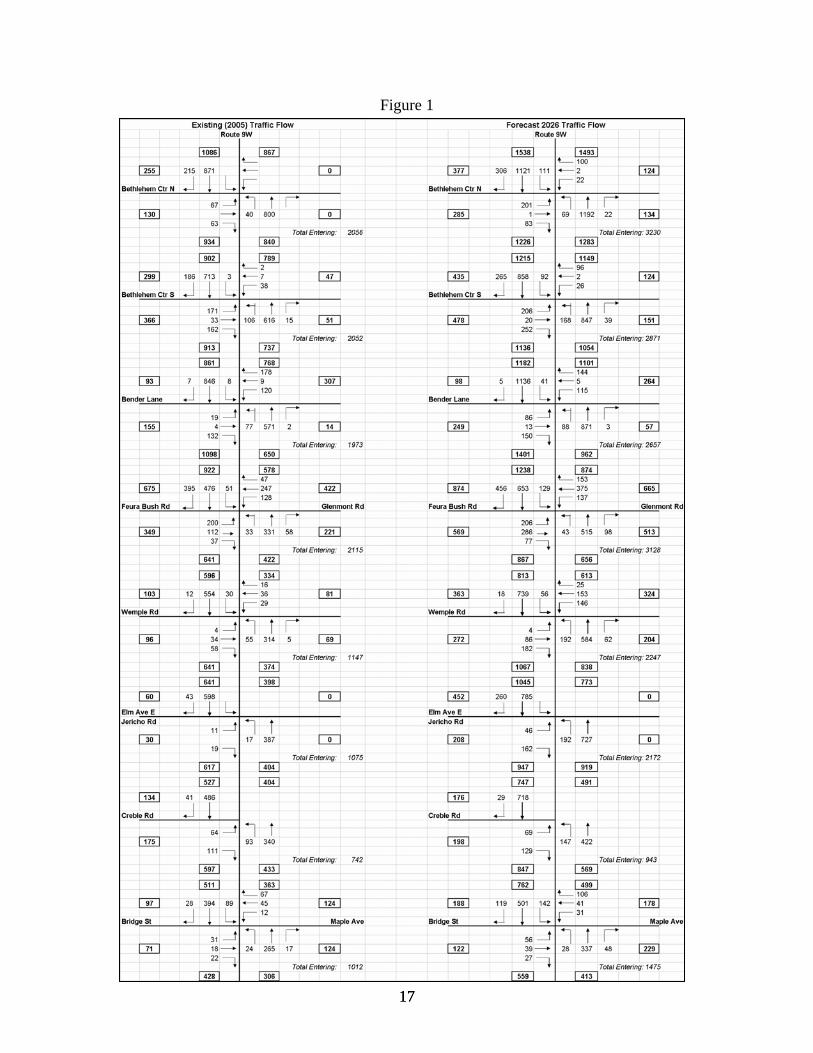
Figure 1
17 17
WHAT ARE THE DRAFT PROPOSED TRANSPORTATION IMPROVEMENTS AND LAND USE ACTIONS FOR THE 9W CORRIDOR? Recommended Transportation and Land Use Actions: The study demonstrated that major capacity improvements corridor-wide would not be required to support development under the Comprehensive Plan-based future. The basic transportation recommendations are to facilitate a multi-modal future and preserve and improve the capacity of Route 9W through limited capacity expansion in the northern segment between Route 32 and Feura Bush/Glenmont Roads combined with good arterial management corridor wide that includes raised medians and interparcel connections, roundabouts, improved pedestrian and bicyclist accommodations along 9W itself along with select off-corridor bike/ped networks, and better site design that supports transit and corridor walkability. (Refer to Tables 1-5 “Description of Proposed Actions”, distributed separately for a more detail description of proposed segment improvements.)
Capacity/Traffic Control Improvements
Add capacity via one to two additional travel lanes along with a raised median between
Rte 32 and the Feura Bush Rd/Glenmont Rd intersection Explore replacing most signalized intersections with roundabouts
on Route 9W; specifically Route 9W/Feura Bush Rd/Glenmont Rd and Wemple Road. Also, explore a roundabout at Town Squire Drive.
Implement signal coordination and other ITS technologies to maximize efficiency.
Arterial or Access Management
Construct a raised median on Route 9W in select areas of the corridor. Interconnect commercial parcels on Route 9W as development or re-development
occurs and provide shared driveway access as possible. Establish site access between new and existing commercial development. Develop access management guidelines (standards) intended to manage property access to Route
9W. Access management standards are intended to provide for safe entrance/departure from an arterial and are directed at preservation of roadway capacity, traffic and pedestrian safety, and convenient transit access. These will include driveway spacing and sight distance standards.
Transit
Support existing transit service through enhanced pedestrian and bicycle access and improved site design.
Provide driveway interconnections on the northern segment allowing new transit route through commercial properties on the east side of Route 9W as they develop.
18
Continue the Town’s partnership with CDTA and CDTC to find ways to improve transit service in the corridor and throughout the Town.
Aggressively market regional Travel Demand Management programs to Town residents, business owners, and prospective developers.
Pedestrian and Bicycle Improvements
Improve pedestrian accommodations – fill gaps in the existing sidewalk network and extend sidewalks to the south, upgrade street crossings with cross walks and pedestrian signals where appropriate. Provide mid-block crossings where appropriate.
Provide countdown signal heads and advanced walk phase at each signalized intersection and improve nighttime lighting.
Construct sidewalks on some side streets where appropriate and construct sidewalk and shared-use path linkages.
Develop an off road shared use path network connecting neighborhoods on both sides of Route 9W.
Widen Rt. 9W to provide a 5 foot shoulder marked as a bicycle lane and signage. Resurrect Bethlehem’s Pedestrian Committee – partnering with CDTC and Bethlehem Police to
develop a town-wide safety education campaign targeting both pedestrians and motorists. Land Use
Adopt site design standards that are supportive of transit, walking and bicycling. Adapt setback standards to preserve needed right-of-way to accommodate medians, wide
shoulders, sidewalks and landscape strips. Amend the zoning code and map for land in the vicinity of Wemple Road to promote
formation of a hamlet. Consider zoning amendments in the vicinity of Creble Road to protect the potential
Selkirk By Pass location options, support economic development, and ensure compatibility with By Pass alignments.
Route 9W Aesthetics and Design
Support actions that would create a “green roadway”. establish landscape standards to provide a roadside buffer along Route 9W made of trees,
shrubs, and other vegetation. promote overall corridor beautification of Route 9W to make the roadway a more
attractive place as a business location and place to live and shop.
19

SELKIRK BYPASS
How did the study address the issue of truck traffic in the southern section of the corridor, specifically along Maple Avenue in the Hamlet of Selkirk?
The most significant issue in the southern corridor has been, and continues to be, truck traffic. The area lies between the Town's southern industrial area (which includes the Selkirk Rail Yards) and Exit 22 of the NYS Thruway. The prominent route for trucks traveling between these points includes Creble Road (County Route 55), US Route 9W and NYS Route 396. This route generates a significant volume of truck traffic through the residential hamlet of Selkirk, and creates significant quality-of-life and traffic safety concerns for its residents. Previous studies have documented the truck traffic issue and a proposed bypass road is included in the current long-range Regional Transportation Plan (New Visions) and the Transportation Improvement Program (TIP). The Town Comprehensive Plan views the bypass as essential for resolving the quality-of-life issue for Selkirk and also sees it as a potential opportunity to facilitate economic development in the Route 9W corridor. Until this time, progress on the roadway has been stalled by debate over its alignment, purpose and cost. Resolving the alignment of the Selkirk Bypass is a primary issue of the study.
Through this study, the study team together with the Study Advisory Committee examined the various bypass alternatives, and discussed their findings with the community in a separate public meeting and workshop held on March 22, 2007. NYSDOT's project development work for the Selkirk Bypass identified a 'northern alignment' that would mitigate the impact of truck traffic on the hamlet of Selkirk, but did not evaluate its traffic or environmental impact on the community. The study reviewed the feasibility of a northern alignment alternative to the Selkirk Bypass project. The study team and advisory committee looked at this in the context of a lot more than just a 'Selkirk Bypass' by engaging the community in a discussion of the ability of a northern Selkirk Bypass alignment to support the Town's land use and transportation vision for the corridor. Because a significant component of feasibility is cost, the study highlighted the economic development opportunities that can financially supplement public resources already committed to the project through CDTC's Transportation Improvement Program.
What course of action is the study's Advisory Committee recommending? The Study Advisory Committee recognizes that resolving the truck traffic/residential land use conflict in South Bethlehem is a difficult problem. After reviewing the previous work completed by CDTC, the Town's planning department, and NYSDOT, together with the public input received from the Selkirk Bypass Alternatives Workshop held on March 22, 2007, the Study Advisory Committee recommended that the Central (NYSDOT’s Northern) Alignment -- the extension of Creble Road that would link Route 9W to Route 144 -- as the preferred location because it:
1. Improves the livability and quality of life of the Maple Avenue neighborhood by removing tractor trailer through traffic. Because trucks currently using Maple Avenue are primarily oriented to South Bethlehem and the CSX rail yard, making this
20
new road the truck route will shift freight traffic to a more direct route. Based on the information available to the study team, vehicle miles traveled will decrease by about 35 percent from current travel conditions. Vehicle hours traveled would decrease by about two-thirds. Decreasing VMT or VHT will lower freight operating costs in the corridor. Although automobile traffic levels will not change much on Maple Avenue, overall traffic will decrease because truck traffic makes up a large proportion of traffic on Maple Avenue and because all truck traffic will be prohibited from using Maple Avenue.
2. Reduces traffic burden on Route 9W. With a new interchange in the vicinity of
Creble Road, the Thruway becomes a more attractive travel route for trips destined to South Bethlehem and points south than US 9W or NY 144. Traffic model results indicate that the new road would divert at least 200 vehicle trips from Route 9W to other more direct routes. Reducing traffic on Route 9W lessens the need for major capital improvements to that road, allowing increased reliance on management actions to meet needs.
3. Establishes sustainable economic development opportunities in the corridor that are consistent with the town's Comprehensive Plan and amended zoning law. This alignment allows for turn free, direct access of truck traffic from Creble Road to the Thruway. It also provides for new access to hundreds of acres of developable land between 9W and the Thruway. This alternative is slightly south of the limits of existing development pressure and growth. It is reasonable to project that by the time this alternative could be constructed, there will be growth and development pressure immediately nearby. This alignment has great potential to attract private sector participation in the capital improvements required, as major developers will be very interested in the significant new accessibility and marketability of this area of Town. Although there are constraints in this area (wetlands, steep slopes, crossings), there is significant developable land and the potential for extension of the new road east of the Thruway to Route 144 would allow for orderly growth and planning for development of the river corridor as well. With a Thruway interchange, access to the Selkirk Rail Yards and the Heavy Industrial Zone between Routes 9W and 32 would be greatly enhanced making this area more attractive for new industrial development.
The disadvantage of this alternative is that it will have an impact on the wetlands, farmlands, and scenic vistas of the Vlomankill valley. The precise impact and tradeoffs with benefits will be quantified when the project moves into the preliminary engineering and design phases. If the environmental impact cannot be sufficiently mitigated, falling back to the Southern Alignment would be the only other practical option. An alignment located south of the hamlet would remove most trucks, except those serving existing businesses, from Maple Avenue. Although the relocated road would enhance industrial access, it would not materially improve the marketability nor create access to a significant amount of new acreage, and would impact a ravine and stream in the vicinity of the railroad tracks.
21
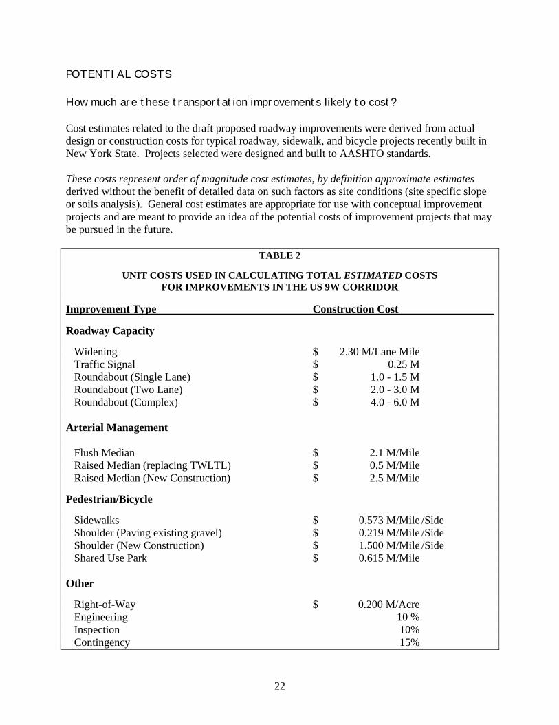
POTENTIAL COSTS How much are these transportation improvements likely to cost? Cost estimates related to the draft proposed roadway improvements were derived from actual design or construction costs for typical roadway, sidewalk, and bicycle projects recently built in New York State. Projects selected were designed and built to AASHTO standards. These costs represent order of magnitude cost estimates, by definition approximate estimates derived without the benefit of detailed data on such factors as site conditions (site specific slope or soils analysis). General cost estimates are appropriate for use with conceptual improvement projects and are meant to provide an idea of the potential costs of improvement projects that may be pursued in the future.
TABLE 2
UNIT COSTS USED IN CALCULATING TOTAL ESTIMATED COSTS FOR IMPROVEMENTS IN THE US 9W CORRIDOR
Improvement Type Construction Cost Roadway Capacity Widening $ 2.30 M/Lane Mile Traffic Signal $ 0.25 M Roundabout (Single Lane) $ 1.0 - 1.5 M Roundabout (Two Lane) $ 2.0 - 3.0 M Roundabout (Complex) $ 4.0 - 6.0 M Arterial Management Flush Median $ 2.1 M/Mile Raised Median (replacing TWLTL) $ 0.5 M/Mile Raised Median (New Construction) $ 2.5 M/Mile
Pedestrian/Bicycle Sidewalks $ 0.573 M/Mile /Side Shoulder (Paving existing gravel) $ 0.219 M/Mile /Side Shoulder (New Construction) $ 1.500 M/Mile /Side Shared Use Park $ 0.615 M/Mile Other Right-of-Way $ 0.200 M/Acre Engineering 10 % Inspection 10% Contingency 15%
22
How can these transportation improvements be financed?
Because competition for federal and state funding is extremely tight and regional needs extensive, public financing through traditional sources cannot be assumed. Public/private sharing of the costs of new transportation infrastructure will be key to successful implementation of the plan. One approach would involve calculating cost share based on the amount of roadway capacity consumed by traffic generated by development in the study area. This approach is described in some detail in CDTC's report, Procedures for Public/Private Financing in the Capital District. The Town of Colonie has successfully used this approach in assessing transportation mitigation fees for GEIS improvements in the Albany County Airport Area. Since this funding method apportions cost shares based on the amount of additional capacity that is consumed by a particular development, a development that generates many vehicle trips would have a higher total cost share than a development that generates few vehicle trips. Public funding would be used for costs attributable to non-local traffic and to the creation of reserve capacity. Under this approach, full private developer funding of certain improvements can be considered if the warrant for the improvement is primarily to serve local development related traffic and not existing and new through traffic. An alternative approach involves the use of a transportation development district. Under New York State law, special transportation districts may be created where property owners or tenants cooperate to "tax" themselves for improvements which would be of mutual benefit in a particular section of the community. A Transportation Development District in Northwest Niskayuna would be an example of such a district. The purpose of the District would be to defray the cost of constructing roadway improvements identified in the rezoning proposal. Under this approach, the Town may need to commit to financing the full cost of the project up-front. As development in the study area occurs, mitigation fees would be collected to cover the debt service attendant to any bond acquired to finance the project. Although Transportation Development Districts have not been used in the Capital District, they have been used elsewhere in New York State. How much revenue will need to be raised using CDTC's public/private funding approach, assuming planned 2026 development levels? Table 3 shows one possible funding plan. The plan assumes that at least half of the total cost ($38 million) would need to be financed by the private sector. Under this assumption mitigation costs would average $4.20/SF for industrial development, $9.17/SF for commercial development, and $3,300/unit for residential development. By comparison, GEIS mitigation costs in the Albany International Airport area range between $1.50 and $10 per square foot, and between $1,500 and $4,500 per residential dwelling unit.
23
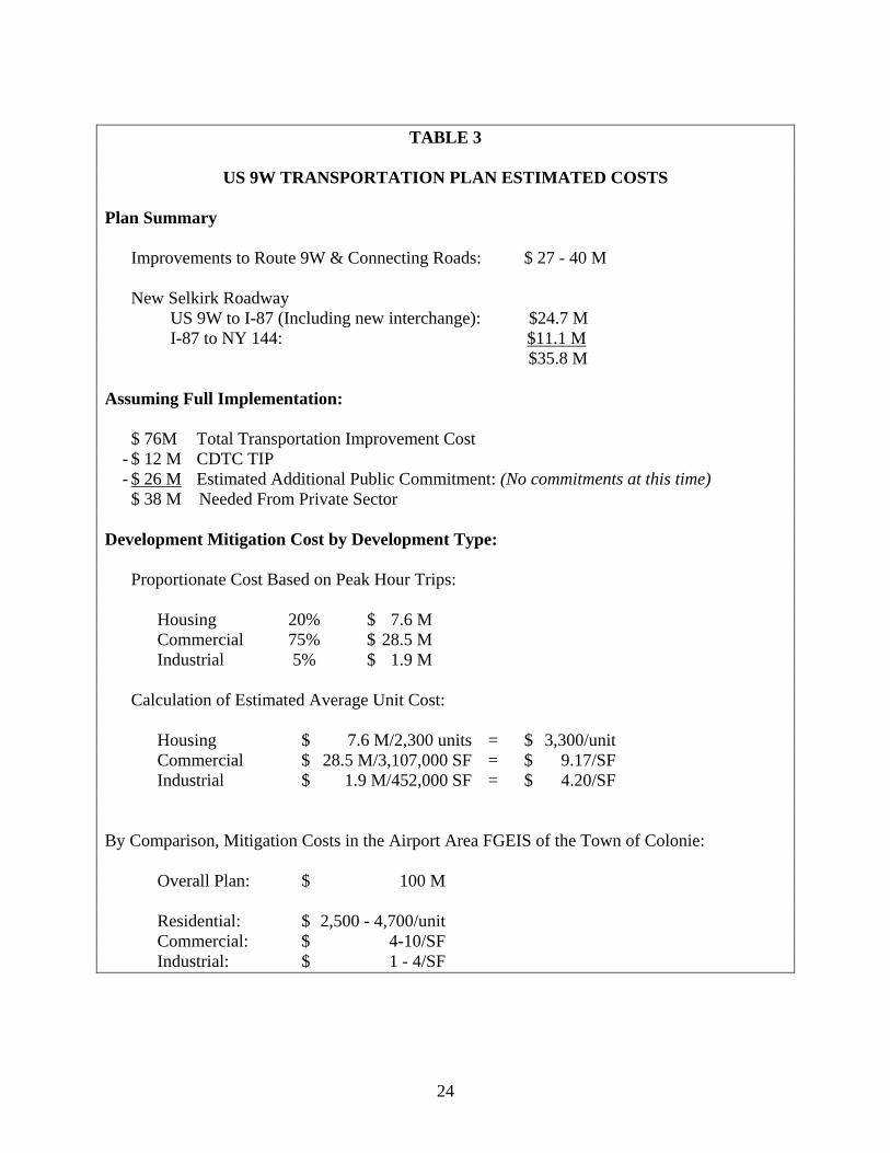
TABLE 3
US 9W TRANSPORTATION PLAN ESTIMATED COSTS
Plan Summary Improvements to Route 9W & Connecting Roads: $ 27 - 40 M New Selkirk Roadway US 9W to I-87 (Including new interchange): $24.7 M I-87 to NY 144: $11.1 M $35.8 M Assuming Full Implementation: $ 76M Total Transportation Improvement Cost - $ 12 M CDTC TIP - $ 26 M Estimated Additional Public Commitment: (No commitments at this time) $ 38 M Needed From Private Sector Development Mitigation Cost by Development Type: Proportionate Cost Based on Peak Hour Trips: Housing 20% $ 7.6 M Commercial 75% $ 28.5 M Industrial 5% $ 1.9 M Calculation of Estimated Average Unit Cost: Housing $ 7.6 M/2,300 units = $ 3,300/unit Commercial $ 28.5 M/3,107,000 SF = $ 9.17/SF Industrial $ 1.9 M/452,000 SF = $ 4.20/SF
By Comparison, Mitigation Costs in the Airport Area FGEIS of the Town of Colonie: Overall Plan: $ 100 M Residential: $ 2,500 - 4,700/unit Commercial: $ 4-10/SF Industrial: $ 1 - 4/SF
24
WHAT ARE THE NEXT STEPS?
The study team will review the comments received at today’s public meeting with the Study Advisory Committee.
The study team will pull together the material talked about today, the findings of the
Selkirk Bypass workshop and focus group meetings, and comments, suggestions, and direction that we have received from various stakeholders including NYSDOT, the New York State Thruway, CDTA, Bethlehem Tomorrow, Bethlehem residents and business owners, Route 9W property owners, and others. A report will be prepared and presented to the Study Advisory Committee reflecting all of this information and any necessary amendments or refinements to the draft Rt. 9W Corridor proposal.
Subsequent to review by the Study Advisory Committee, the report will be presented to
the Town Board for possible adoption as an amendment to the Town Comprehensive Plan.
PRIORITIES WORKSHEET
Please take a few minutes, either here or at home to complete. The worksheet is being distributed separately from this workbook.
25


![EXPERIENCE POWER COLOR · 3 coloronix 3" recessed square accent pg.8 recessed ceiling downlight srq3led19 9w 3" downlight & adjustable spot pg.9 sr3led_ [21] [01] [71] 9w 6" recessed](https://img.pdfslide.us/doc/110x75/5f452adb850c7d12b115f529/experience-power-3-coloronix-3-recessed-square-accent-pg8-recessed-ceiling.jpg)