Embed Size (px)
Citation preview


Blendworth Church

1
1.5. Who is it for?It is intended for:• Local householders and businesses;• Statutory bodies and providers of services and utilities;• Local councils;• South Downs National Park Authority;• Developers and builders;• Architects, designers, planners and engineers.
1.6. What does it coverThe VDS contains the following sections:1. Introduction;2. Heritage, including; the history of the parish,
conservation areas, historic buildings andarchaeological sites;
3. Settlement pattern;4. Horndean’s natural heritage;5. Environmental issues;6. Roads traffic and transport;7. Commerce;8. Recommendations and design guidelines;A. Appendix of supporting information;B. Appendix listing documents used for reference during
the preparation of the statement plus contact detailsfor further information;
C. Appendix Credits and contacts.
MapsThe following maps are included within the document:a) Aerial photograph of Horndean Parish in 2000 showing
boundary and main settlements;b) Horndean in 1910;c) Listed buildings in Horndean;d) Local Biodiversity Designations in Horndean Parish.
1. Introduction
1.1. What is a village design statement(VDS)?
Village design statements are intended to provide designguidance for any proposals for development and to influencethe way the planning decisions are made.
1.2. Why produce a VDS for Horndean CivilParish?
The aim of the VDS is to raise awareness of what is specialabout the area, give guidance on respecting these featuresand help to ensure that any development or change is onlyundertaken after consideration of these features.
1.3. How has it been produced?The VDS has been produced by residents of the parish withthe support of Horndean Parish Council and East HampshireDistrict Council. It is the result of public consultationinvolving the whole parish at all stages including:• Public meetings, exhibitions and displays;• Opportunities for residents to comment on a draft
version;• Consultation with district council planning officers.
1.4. How will it work?The VDS describes the settlements in the Civil Parish ofHorndean as they are now and highlights the qualities thatresidents value. It is intended to be a practical tool capableof influencing decisions affecting design and development inthe parish. It should assist Horndean Parish Council andEast Hampshire District Council to consider planningapplications.The Village Design Statement is in line with the adoptedEast Hampshire District Local Plan: First Review. The plan iscurrently being reviewed and a revised version will beadopted in 2005. A second version of the review plan waspublished in January 2002. The VDS is one of a set of localaction plans being prepared by the parish. This set includesthe local nature conservation plan.Guidelines, which relate to design are presented on a yellow background and have been adopted by the districtcouncil as supplementary planning guidance on design.Other guidelines and proposals are presented on a green background. Authorities other than East HampshireDistrict Council are responsible for some of the issuesaddressed. The authorities considered by the HorndeanParish Village Design Group to be responsible forimplementing or promoting the improvement have beenindicated after the recommendation. The VDS and inparticular the recommendations must be read along with thelocal plan and other current planning guidance.
Horndean Parish Village Design Statement

2
Lovedean
WesternHorndean
Catherington
South Horndean

3
NorthHorndean
Blendworth
Horndean Village
Hazleton
Aerial Map of Horndean in 2000
© East HampshireDistrict Council

4
2. Heritage
2.1. History of HorndeanHorndean Civil Parish was formed in 1932 and covered thesouthwest part of the Hundred of “Ceptune” or Finchdean.Various changes of boundaries have altered the area and itnow covers much of the old Catherington Parish andBlendworth Village. There is evidence of Roman occupation from the northernboundary of the parish to Causeway Farm. Catherington andBlendworth appear to have been founded as mid Saxonsettlements. The oldest building in the Parish is the 12thcentury Church in Catherington. In the 16th century tradesother than farming existed in Catherington and Blendworth.At about this time Horndean Village was established and bythe 17th century Catherington had a general store. It wasthe development of Portsmouth Dockyard, which by 1711employed over 2000 men that influenced the growth ofHorndean and helped it to become a focal point in the 18thcentury. The growth of traffic lead to the establishment ofthe Portsmouth to Sheet turnpike road and the volume oftraffic resulted in the expansion of the village inns andshops. In 1816 the enclosure of 2000 acres of largelycommon land added to Horndean’s post Napoleonic Warproblems and Horndean figured in the ‘Swing’ riots anddisturbances of 1830-31. By this time Horndean Village hada population of 300 and Catherington 1100. The mostprominent development in the 19th century was the growthof Gales Brewery between 1847 and 1896.The arrival of the Portsmouth and Horndean Light Railwaywas the first of the many changes in 20th century. Theinstallation of mains supplies of water, electricity and mainsdrainage occurred during the 1920s and 30s. By 1939Horndean Civil Parish had a population of 3000 whichincreased when people were evacuated from London andPortsmouth during the Second World War. In 1948 the
Grain store Catherington Lane
development of the Merchistoun Road estate wascommenced. The building of the Hazleton Estate wasstarted in 1950s. The A3(M) was opened in 1979.
2.2. Conservation areas and potentialconservation areas
There is currently a conservation area in Horndean Village.Catherington Village is currently under consideration forconservation area status and Blendworth Village is alsoconsidered to merit conservation status.
2.3. Historic BuildingsThere are no grade one listed buildings within HorndeanParish.The grade two buildings are listed in Appendix A1.
2.4. Archaeological SitesThe Hampshire County Council Archaeological and HistoricBuildings Record lists approximately 85 archaeological siteswithin Horndean Parish. Several artefacts such as flintimplements, pottery and coins have been found in fieldsthroughout the parish showing a continual occupation sincethe Stone Age. Two significant sites are the Anglo-Saxonburial site at Snells Corner, which also contained Romanburials, and a Romano-British farmhouse at Kingsmeadwhich produced many pottery finds known as HorndeanPottery. The Kingsmead site is now built over. Also listed arethe strip lynchets, which run along both sides of LovedeanLane from Catherington Hill to Coldhill Lane. There are alsogroups of sites listed in Catherington and Blendworth.

5
Horndean in 1910 - extract from Ordnance Survey Hampshire sheet LXVIII NE 1911 Edition

6
Horndean in 1910 - extract from Ordnance Survey Hampshire sheet LXVIII NW 1910 Edition

7
Horndean in 1910 - extract from Ordnance Survey Hampshire sheet LXVIII SW 1910 Edition

8
Village. It was first documented in1199 as Harmedene (Field MouseValley). New development has seenHorndean village grow into the mostsignificant of the settlements in termsof commercial development. The areaextends along Portsmouth, Havant andLondon Roads and is considered bysome to be bounded by the twomotorway bridges. Havant and LondonRoads run along a dry valley. Part ofthe village is a conservation area,which includes the square, Gale’s mid19th century brewery, severalassociated flint and brick cottagesalong London Road and the nineteenthcentury post office. To the rear of thebrewery is Crookley Park, anattractively sited mansion set inmature woodland. Outside theconservation area there are industrial
3. Settlementpattern
3.1. Landscape and settingThe Parish of Horndean has apopulation of approximately 13,000and is made up of several settlementsincluding Blendworth, Catherington,Horndean Village and parts ofLovedean and Hazleton. It lies on theA3 approximately 8 miles south ofPetersfield. There were separate anddistinct zones between thesettlements, but with progressivedevelopment the area has evolved intoa conglomeration that has overrunmost of the earlier settlementboundaries.Much of the village is situated in avalley that forms a dividing linebetween chalk downland to the northand a formerly well wooded area tothe south, that is close to the originalboundary of the Forest of Bere. To aidclarity the description of Horndean hasbeen divided to align with the principalsettlements.
3.2. Horndean VillagePerhaps the only location that couldclaim to be the centre of HorndeanParish is the square, which issurrounded by several public housesand shops and Gale’s Brewery. Thisarea is also referred to as Horndean
Havant Road proposed building site
Horndean Square
London Road

and old school. The village retains a mixof 16th to 18th century houses andcottages, typical of a village associatedwith a long standing farming community.House building has followed anintermittent, ribbon style developmentwithin the village, along the lanesapproaching the village centre andadjacent to farms. There is no backlanddevelopment and there are no estates.
3.3.2. Blendworth Village Centre
Within the centre are several notablebuildings dating from the 18th and 19thcentury, many have flint, or flint andbrick facing and some with hanging tilefacing and many have tiled roofs.
Blendworth House, a large house with associatedoutbuildings; Myrtle Farm barn; Holy Trinity Church and theOld School Buildings are notable buildings in the centre.
3.3.3. Old Blendworth
Old Blendworth includes Blendworth Farm that has anumber of flint outhouses and slate roofs and the medievalsite of St Giles churchyard. St. Giles church was demolishedin 1961.
3.3.4. Pyle Lane
Pyle Lane is fringed by a number of notable buildings datingfrom the 16th, 17th and 18th centuries. There are examplesof timbered and half-timbered cottages, thatched roofs, flint
9
estates along the motorway. The Precinct in PortsmouthRoad is an untidy collection of under used shops, whichmight benefit from redevelopment. Havant road consists ofpleasant modern housing developments and is home to alarge retail nursery.
Other Issues• Consideration should be given to redeveloping the
site to the Northwest of the A3, in-between the postoffice and the A(3)M. The development should be inkeeping with the style of the conservation area andshould be planned to improve the appearance andvalue to the community of this site. Thedevelopment appraisal should include considerationof the car parking needs of the village. The designshould be flexible to encourage varied use andaccommodate the changing needs of the parish andof technology. (Responsible authority is EastHampshire District Council. (EHDC))
3.3. Blendworth
3.3.1. Area description
The Village of Blendworth lies to the east of the Parish ofHorndean. It was first documented in 1170 as Blednewrthie(Bleadna Farmstead) and is noted on Saxton’s Map ofHampshire 1575, as Blenworthe. Blendworth is a rural,farming settlement, with the village centred on the church
Thatched Cottage Blendworth (St.Giles area)
Blendworth (St Giles)
Myrtle Farm
Myrtle Cottages

10
facing with brick dressing andtraditional dormers. There are severallisted buildings including 18th centuryPyle Farm and its barn, 16/17thcentury cottages at numbers 107,108 and 109, Pyle Lane, the 18thcentury Hook Cottage and the Barn atNobles Farm.
Design Issues• With no local facilities,
school or transport linksand served by minor roads,Blendworth is not suited tofurther development. In-filldevelopment or extensionsshould only be allowedwhere it does not effectthe setting of existingdwellings or the characterof the village. Thoseallowed should be built toreflect the style andmaterials of theolder/original buildingsrather than continue therecent trend of modernstyles and finishes. (EHDC)
Other Issues• Consideration should be
given to creating a‘Conservation Area’ inBlendworth. (EHDC,Horndean Parish Council(HPC), Residents)
3.4. Catherington
3.4.1. Area description
Catherington Village is a hill topsettlement, which has developed itsunique characteristics over severalcenturies. To the west, fromCatherington is open countryside withhedges and hardwood trees and viewsof Hinton Manor, Hinton Daubnay andthe Observatory. To the east, is NorthHorndean with the windmill on theopposite hill. To the north ofCatherington Church there are moderndevelopments in the Glamorgan andDownhouse Road areas that form anorthern extension to CatheringtonVillage.The area to the west of Catheringtonis proposed for inclusion in thenational park. Catherington Down is alocal nature reserve, a Site of Special
Scientific Interest (SSSI) and a placefull of wildflowers in summer wheremany people come for a walk to enjoythe scenery. There are medieval striplynchets on Catherington Down. Thesecan be seen clearly both in the naturereserve and south as far as TagdellLane. Catherington Down is within theproposed area for the national park.
3.4.2. The village
The centre of the village was basedon St Catherine’s Estate. Thisincludes, on the west side ofCatherington Lane the three terracedTudor cottages, a converted forgeand the two circa 1720 convertedsemi-detached groom’s andgardener’s cottages. The 12thcentury church of All Saints with theOld Vicarage opposite stand at thetop of the hill.
A new vicarage was built alongside thechurch in the late 1960s and a churchHall in 2000. Further to the north isthe 18th century Butts Cottage andthree modern houses which wererebuilt and extended in the 1990s.South of the churchyard on the eastside is the village pond, with theCatherington sign. Adjacent to thisstands the flint faced village school,built in 1852, and extended in 1997.
Opposite this is a pair of tile hungsemi-detached school cottages. Thepresent public house replaced athatched building burnt down in the1920s. To the south the roadnarrows at the 18th centuryCatherington Cottage, beyond whichis the saddlery with two modernhouses. Continuing southward past the 17thcentury Farm Cottage and Kinches
16th Century Cottage Catherington
Catherington House

11
Farm, is the Georgian CatheringtonHouse, now a school, with its 2 acrewalled garden planted with specimentrees. Across Five Heads Road fromCatherington House is the Georgian‘Farmhouse’.
Still further south, on the east side isRandell’s Farm and Randell’s FarmCottage. Opposite these to the west is aribbon development of modern housesand bungalows, which stretch almost toCrouch Lane. The field below Randell’sFarm Cottage forms a green buffer to thesouth of Catherington.
Other Issues• New development of any kind in Catherington
Village should as far as possible be avoided; • In the wider Catherington area there is very little
scope for development without reducing theattractiveness of the area; (EHDC)
• It is recommended that Catherington Village isgiven ‘Conservation Area’ status. (EHDC, HPC,Residents)
3.5. North HorndeanNorth Horndean is a mix of approximately 1550 houses,bungalows and mobile homes of predominantly privateownership and developed mainly over the last 50 years,with some slightly older property along the old A3. Thereare a small number of low cost homes owned by a housingassociation. The two mobile home parks provide much
Catherington Cottage
Kinches Farm
Bungalow set on a hill North Horndean
needed accommodation. The area includes several grassedopen spaces provided by various developers. NorthHorndean derives considerable benefit from being boundedon the west by Catherington Lith, a large area of managedwoodland with public access. The northern end of theestate is well served by shops and services, which liemainly in Clanfield. Close to the A3(M) are Highcroft andHillside industrial estates, that consist of a number of lightindustrial units, including small starter units.
Design Issues• Around Viking Way, in the north of the estate,
bungalows are set on the crest of the hill andhave a high profile. If any of these wereextended into two storey dwellings, it would spoilthe appearance on the crest of the hill lookingwest. (EHDC and property owners)
View of North Horndean
Viking Way North Horndean

12
3.6. LovedeanLovedean was first documented in 1350 as Levedene(Leofa’s Valley). Lovedean is a triangular area that lies in thewest of Horndean. It is generally considered to be boundedby Frogmore Lane to the east, Crouch and Day Lanes to thenorth, the Havant Borough boundary to the south and theDenmead boundary in the west. In the early 1900s theVictorian County History called Lovedean ‘a fair sized hamletwith a smithy and general shop’.
The sides of the valley to the east and west of LovedeanLane create the visual character of the main settlementarea. There are many buildings originating from the 16th to18th century clustered either side of Lovedean Lane in thisarea, which indicate the historic centre of village life. Thehistoric buildings consist of timber framed thatchedcottages and more recent 18th century houses, LovedeanFarm and the Lovedean Dairy with flint faced walls, redbrick detail and dressing. The two 17th century exposedtimber-frame cottages at 224 and 226 Lovedean Lane areGrade 2 listed.A ribbon development of houses has been built alongLovedean Lane since 1940. Estates have also been builton side roads to the east and west of Lovedean Lane.These are mainly of low profile, bungalow design, with brickand tile construction. The southern part of the settlement,within the Havant boundary, has been subjected toextensive urban development. The area of Lovedean thatlies within EHDC remains essentially rural in naturebounded by farmland and woodland copses. The rural character of Lovedean forms a visual transitionfrom the urban south to the Proposed National Park to thenorth of Day Lane.
View from Yoells Lane over Lovedean Lane to James’s Copse
Lovedean Village Hall, situated in Lovedean Lane, wascompleted in 1957 to serve the growing community and is athriving centre for many local clubs and activities.
Design Issues• Future development or commercial activity should
not remove or spoil the setting of the buildingsforming the historic centre of the settlement. Theribbon development along Lovedean Lane shouldbe protected from backland development up thevalley sides. Development should only beundertaken on small, low profile sites, usingmaterials and styles to compliment theestablished village character and dissipate theeffect of traffic hence avoiding increasedcongestion in South Horndean. (EHDC)
3.7. Hazleton3.7.1. Hazleton is a large estate locatedapproximately half in Horndean with theremainder in Havant District. It wasconstructed in 1960’s with low to mediumdensity housing which is mainly bungalowsand 2 storey houses constructed of brickand tile with well developed gardens. It isloosely bounded by the A3 PortsmouthRoad and the A3(M). The estate has apleasant open layout that gives it a roomyfeeling. Unfortunately, it has only limitedroad access at it’s northern and southernextremes.
Old Farm Buildings Lovedean Lane
Cottages in Lovedean Lane
Tudor styled house in Loxwood Estate Lovedean backing ontoYoells Copse

13
There are some shops, a public house and alocal bus service. Recreational spaces arelocated at The Dell and Hazleton Common. Theformer contains a children’s play area andgrassed area; the latter is a local naturereserve. In between Rosemary Way, Briar Closeand Portsmouth Road there is an area ofwoodland that extends over several gardens.This acts as a natural gap between the estateand Portsmouth road and has developed as aspace for wildlife. The estate was built to copewith approximately one car per house while thepresent car density is significantly greater. Thishas resulted in congestion and clutteredstreets.
There is little opportunity for further newconstruction within the estate. The need is toretain the surrounding open spaces, limit noisyand dirty developments across the A3(M) andmaintaining the buildings within the present style.
Other Issues• The large gardens in-between Rosemary Way,
Briar Close and Portsmouth Road should not beused for infill development as they provide avaluable and attractive gap between the mainroad and estate. (EHDC)
3.8. South Horndean
3.8.1. Area description
South Horndean lies north of the Havant boundary, betweenthe A3, Lovedean Lane and to the south of Five HeadsRoad. It includes suburban development, housingapproximately half of the Horndean parish population, itcontains several open spaces, the Horndean Campus and anumber of distinctive buildings. It borders Yoells Copse andincludes several smaller groups of mature trees. SouthHorndean currently has a high car density, which mayincrease with proposed developments. In an area such asthis, with poor services and limited public transport, the useof a car is deemed as essential and as a consequence,there is a considerable amount of street parking.
3.8.2. Historic buildings
Merchistoun Hall has a 300-year-history. The house hasimposing colonnades, is set in pleasant gardens and ismanaged and maintained by the Horndean CommunityAssociation. It is adjacent to a stretch of woodland, whichskirts Portsmouth Road. To the rear of Merchistoun Hall, inMurray Road is Merchistoun Farm House.
Five Heads House, originally documented in 1431, is a 19thcentury two-storey plaster faced building with tiled roof andtwo gables on the north end. It includes a flint annexe,which is now a separate residence and is surrounded with agroup of mature copper beech and robinia trees. InPortsmouth Road and Five Heads Road there are severalearly 20th century houses of a distinctive style. Also in Portsmouth Road is a white fronted building, whichwas formally an independent Methodist chapel.Close to this chapel is St. Edmunds the Horndean Roman
18th Century grade 2 listed Merchistoun Hall
Bungalow on Hazleton Estate
The Dell

14
Catholic Church. Causeway Farm has been extended andconverted to warden controlled accommodation, aconversion which has retained the flint-faced barn. At thesouthern end of Catherington Lane, is a row of 19th centurycottages.
3.8.3. The schools
Horndean Technology College, located in Horndean Campusis the largest secondary school in Hampshire. The schoolwas originally constructed in the 1960s with a building styleof that period. It has developed in what appears to be anunplanned and uncoordinated manner and the appearanceof some of the buildings are not good. On the positive sideit contains many facilities that are of value to the communityincluding a large hall and a sizeable playing field which issupplemented as anopen space by therecreation ground inFive Heads Road.Horndean Junior andInfants schools arelocated near thejunction ofMerchistoun Roadand Five HeadsRoad. They arehoused in singlestorey flat roofedbuildings. Much ofthe junior school isin dilapidatedtemporary buildings.The styles of theschool buildings
contrast with the local buildings in particular to the late19th century and early 20th century library and housingclose to them in Five Heads Road.
3.8.4. Estates
South Horndean includes several estates each with its owndifferent style. Merchistoun Road was originally a socialhousing development, with an open development structureand wide roads, it includes several greens and a number ofprominent old oak trees.
Catherington Lane from Roundabout
Oak in Merchistoun Road
Catherington Lane approaching Campus
Former Independent Methodist Church in Portsmouth Road
FiveHeads Road close to Junior School
Horndean Library FiveHeads Road

15
documented on the site in 1167 and it is possibly the siteof a shrunken village. Broadway Farm House, which was firstdocumented in 1350 is in the south of this area.
3.10. Parish overview
Description
Horndean Parish is located immediately north of theCowplain/Waterlooville built up area. Approximately 2kilometres of the southern boundary runs through asuburban area. North Horndean has a short common builtup boundary with Clanfield. These two boundaries are linkedby a continuous development along Portsmouth and LondonRoads. This makes any proposal for future erosion of thegaps between settlements and loss of planning gapsbetween Cowplain and Clanfield, a sensitive issue.
How the parish has developed
Horndean has developed over the centuries but most of thedevelopment has been in the last 50 years. WithinHorndean Parish there are three settlements, Catherington,
Blendworth and part of Lovedean thatretain areas of historic significancedating mainly to the 16th, 17th and18th centuries. In and aroundHorndean Village there are manybuildings dating from the 19th andearly 20th centuries. Also there areseveral estates constructed over thelast 50 years. Since the completion ofthe Hazleton Estate in the 1960’s thecontinuing development has moved thecentre of habitation in the parishwestwards. This has resulted incommunity facilities being dislocatedfrom much of the community. The localshops, services and facilities have notincreased as they should have. Manyresidents no longer consider theHorndean Precinct to be an asset andas a consequence, travel out of thearea, leaving the parish with a lesseffective community and fewer servicejobs. Many residents regard HorndeanParish, not as a single community, but
Kingsmead comprises mainly bungalows located around alarge green. Murray Road has a mixture of housing includingsome, near Portsmouth Road, with flat roofs. Highcroft ismainly 1960 to current day housing, with a few houses thatare older.
In-between Kingsmede and Stonechat Road are several smalldevelopments from the last 40 years. Stonechat estate hasrecently been built to the west of Catherington Lane. It has a higher housing density than most estates inHorndean but externally it retains a pleasant appearance. Ofparticular note is that several mature trees have beenretained and grassed squares left around them. A number ofhouses are built in a traditional local style some with half-hipped roofs, flint and brick facings and hanging tiles.
3.9. West HorndeanTo the north of Lovedean and to the west of Catheringtonand within the parish is a large area of open country. Thearea is of scenic value and is predominantly agricultural landwith a scattering of woodland copses. Most of this area isproposed for inclusion in the National Park. The areaincludes several farmhouses and cottages of note. HintonManor House is a substantial flint and brick grade 2 listedmanor house, parts of which are reported to be 13thcentury. The barns have been converted into housing. Thepresent flint and brick house at Hinton Daubnay is 19thcentury and is set in wooded grounds. Buildings were first
Looking south along Broadway Lane at Hinton Daubnay
Hinton ManorStonechat Road - flint faced and half hipped

16
as a conglomeration of estates with no centre and littleactive community. If a centre with facilities is to develop andadd to the appearance of the parish it must be supported bya majority of the population. There is a case for furtherstudy to identify the type of centre that is required, itsappearance and suitable location.
Travel and congestion
People’s expectations of being able to travel freely haveincreased considerably over the years. People who live inHorndean have little opportunity to travel unless a car isused. This has resulted in most estates being home tomore cars than they were planned to house, which degradesthe appearance and causes local congestion. Furtherdevelopment to the west, either in Lovedean or in the northwest of Cowplain, will increase the volume of traffic feedingthrough congested minor residential roads to access the A3or A3(M).
What is special about Horndean Parish?
Although the parish has developed in what appears to be anuncontrolled way, provides few services and has transportproblems, it is still possible for most residents to accesscountryside with only a few minutes walking. Additionallymany areas of woodland and downland remain, which areeasily accessed using the network of footpaths. Most of thedeveloped areas of the parish have an open appearanceespecially where mature trees have been retained withindevelopments. Also a number of high quality historicbuildings have been retained, many in their original setting.All of these features enhance the appearance of the parish.These benefits should be retained and enhanced.
Good examples of recent developments
The following are examples where a recent development haseither retained the style of the parish or has made a localimprovement:• The development work undertaken in converting Hinton
Manor farm buildings into dwellings is considered a goodexample for future developments of this type;
• Within the Stonechat Estate several local building styleshave been used and mature trees have been retainedwithin grassed squares;
• During the redevelopment of Causeway Farm to wardencontrolled accommodation the flint faced barn has beenretained;
• In the conversion of Catherington House for use as aschool an outhouse has been converted into aclassroom retaining the style of the grade 2 listedbuilding;
• The issue of car parking is considered to have beenwell planned as part of the redevelopment of buildingsto create Knighton Corner;
• The opening of the sports shop in Portsmouth Roadfollowed a conversion of the building. This developmentbrought into Horndean a specialist shop, which is notreliant on others to attract customers. The renovation ofthis building together with the rebuilding of theveterinary surgery next door has upgraded theappearance of the location;
• Gales Brewery has put on display some of theirprevious equipment. This enhances the historic elementof their brewery tours bringing more people into thevillage.
Kings Court School, conversion of outhouse into classroom
Conversion of Barn at Hinton Manor
Causeway Farm, conversion of Flint Barn
The Veterinary Practice.

17
Design Issues
Guidelines for redevelopments and alterations toexisting buildings
Almost every building whether old or new has atsome time been subjected to change. Changes mayhave been made to convert a building to fit theowners needs or tastes or to accommodate achange of use or the changing needs of the time.Failure to modernise can limit the usefulness of abuilding.If the character of an area is to be retained thefollowing guidelines for building redevelopment andalterations should be observed:• Materials, components and styling should be
original or of a sympathetic match to those onthe existing building; (EHDC and property owners)
• Redeveloped or altered buildings should be inproportion to and closely match the existingbuilding and should not dominate or spoil theperspective of the surroundings; (EHDC andproperty owners)
• Existing hedges and trees should be retainedwhenever possible and the use of hedges asopposed to fences should be encouraged;(EHDC, HPC and property owners)
• Boundary walling and fencing in terms of height,width and suitable blends of materials should bein keeping with the surrounding area; (EHDC andproperty owners)
• On more recent properties, third storydevelopment should in most cases be limited todormers that retain existing rooflines. In theolder areas such developments may beinappropriate; (EHDC)
• The conversion of front gardens to hard standingfor the purposes of car parking needs to bediscouraged. This is primarily a feature of scale.There will be cases where an extra parking placecan be fitted in without changing the generalappearance but the conversion of the whole offront gardens into parking lots can degrade theappearance of the immediate area and should bediscouraged; (EHDC and property owners)
• When adding security and communicationsdevices including external lighting care should betaken not to clutter the building or encroach onsomeone else’s domain. (Property owners)
Guidelines for new construction
The following are points for consideration:• An attempt should be made to retain the style of
the area and where lost regain it; (EHDC,property owners and developers)
• There should be due consideration for safety. Forexample pedestrian access to new developmentsfrom local shops & services should not beacross major roads; (EHDC and developers)
• Construction styles: New construction should bein character with its part of the parish. Newbuildings should be designed to reflect and respectnearby colours, textures, materials shapes andstyles and proportions. Styles traditional to thearea such as flint faced or hung tile buildings and
half hipped roofs would be appropriate in newdevelopments; (EHDC and developers)
• The setting of listed buildings should beretained; (EHDC)
• Where a development includes low cost housingthere should be consultation at an early stage toensure that the low cost housing is of a similarstyle and appearance to the rest of the estate. Itshould also be ensured that the estate has beenfully integrated to maximise the standard of lifeof residents; (EHDC and housing associations)
• A discouragement of flat roofing in favour ofpitched and tiled roofs would, in most parts ofthe Parish, enhance character;
• Hedges and trees: Existing hedges and treesshould, whenever possible, be retained in newdevelopments. When trees are retained theyshould be allowed room to develop to their fullstature without putting surrounding buildings atrisk. New plantings of hedgerows should includea mix of native species that are characteristic ofa large number of Horndean hedgerows andinclude hawthorn, blackthorn, hazel, field maple,ash and holly; (EHDC and developers)
• Informal open space, sports areas andassociated facilities should be included in futuredevelopments to provide play areas withinreasonable distance to the residences. Openspaces should include facilities for all agegroups. (HPC and EHDC)
Commercial and industrial buildingsThe following is suggested as a basic set of guidelines forthe design of commercial and industrial buildings thatmight be constructed in the parish: • Buildings should preferably be used for purposes
similar to those for which they were designed,change of use can result in unsightly additionsand alterations that spoil the outline and candamage the surroundings. It would be better tofind an alternative building than to makeunsightly changes;
• The colour and texture of the buildings should besympathetic to other local features;
• The building size, height, shape and externaleffects should fit easily on the site and not crowdout or overlook adjacent areas. It’s use should notcongest or obstruct the surrounding area;
• Peripheral requirements such as parking,servicing and deliveries should be addressed inthe design;
• Screening should be to a good standard andwhere possible should use native trees andshrubs. Both winter and summer appearancesshould be considered;
• The type of activity in the building should beappropriate to its location, for example, wherecommercial buildings are close to housing, thereshould not be escape of noise, light or chemicalpollution. Where heavy vehicle access is requiredthey should be near to main roads;
• Business park type development may be bestsuited to fit into the Horndean landscape;
• Unconventional designs should not beautomatically rejected but their design shouldaim to enhance the area;

18
• If the building is in a prominent position andcannot be effectively screened, it should beconstructed in a locally accepted style usingmaterials similar to the existing local buildingsas indicated above. (EHDC, property owners anddevelopers for all points in this section)
Building materials
• The predominantly used building material inHorndean Parish is brick sometimes with flint orhung tile. There is some use of wood and orplaster facing. On roofs, tiles are predominantbut some older buildings use slate. Many olderhouses have ornate bargeboards; (EHDC,property owners and developers)
• Several older buildings in the parish, including anumber that are listed, use traditional brickworkand or tiles. Repairs and changes to thesebuildings should preferably use hand-made multi-stock clamp-fired bricks, hand made tiles of plainclay and lime mortar for bonding. (EHDC andproperty owners)
Other Issues
Guidance for the retention of the appearance ofthe Parish:
• If Horndean is to develop as a community and toremain a pleasant and attractive place to live, itmust have the services including entertainmentsappropriate to a parish of its size. To achievethis, space needs to be kept in the central areasto retain the landscape character of the parishand also for walking and development ofservices. The open spaces, which should beretained, are listed in appendix A3. In additionthe space between the Roman Catholic Churchand Portsmouth Road; the open spaces in theMerchistoun Road Estate; and the area aroundthe ancient oak in the site proposed fordevelopment in Havant Road should be retained;(EHDC) and (HPC)).
• Future development should assist in balancingHorndean Parish around existing retail and otherfacilities;
• Facilities: Over the last 40 years the housingstock in the parish has been significantlyincreased without the appropriate increase tofacilities. This position needs to be correctedprior to any further significant housingdevelopment; (EHDC)
• There should be an attempt to segregatehousing from un-neighbourly industrial andcommercial developments; (EHDC)
• Noise levels: Residential developments shouldonly be permitted in areas with low noise levels;(EHDC)
• New construction should be kept away fromvisually attractive sites such as the remainingchalk downland; (EHDC and developers)
• The issue of low cost housing often arises.Horndean does have some housing in this band
but possibly not enough. There has been someexpansion of low cost housing stock in recentdevelopments but the balance between thisgroup and more expensive housing needs to bemonitored carefully; (EHDC)
• Consideration needs to be given to housing forolder members of the community. This includes,single storey housing, warden controlled andsupported housing. At present there are asubstantial number of bungalows but there is alimited amount of other categories ofaccommodation for older people available andthe position needs continual monitoring; (EHDCand housing associations)
• The length of built up boundary with Havant andClanfield should not be extended. Additionallyopen spaces between settlements should bemaintained to prevent Horndean from beingabsorbed in the Waterlooville suburban area.(EHDC and Havant Borough Council should bemade aware of this concern)

19
Circa 1550 Catherington
Early 19c Catherington
1910 Horndean Village
1950 Merchistoun
1980’s Blendworth
17c Lovedean
1880 Blendworth
1930’s Horndean Village
1970’s Horndean Village
1985 Horndean Village
18c Blendworth
1903 South Horndean
Late 1930’s South Horndean
1980 Lovedean
2000 Stonechat Estate
Diversity of building styles and materials in Horndean

20
Local Biodiversity DesignationsHorndean Parish

21
Parish Boundary
District Boundary
AONB (Area of OutstandingNatural Beauty
SINC (Site of Importance for Nature Conservation)
SSSI (Sites of SpecialScientific Interest)
LNR (Local Nature Reserve)
Based upon Ordnance Surveymapping with the permissionof the Controller of HerMajesty’s Office CrownCopyright. Unauthorisedreproduction infringes CrownCopyright and may lead toprosecution or civilproceedings. EHDC LA078964 2002.
SCALE 1: 22000
MAP localConservation Plan
DATE 18/09/02

4. Horndean’s natural heritage
4.1. IntroductionThe parish still retains a good number of open spaces.These include a range of countryside areas from woodlandto downland, providing a range of habitats for wildlife andoffering a varied landscape for local people to enjoy. No lessimportant, are the small more formal green areas within thehousing estates for local recreation, such as The Dell onHazleton Estate, The Causeway off Catherington Lane, theGreens, near Yoells Copse, along Merchistoun Road, theRecreation Ground on Five Heads Road and land offStonechat Road.
4.2. Woodland Horndean contains many fragments of woodland, several ofwhich are identified as Sites of Importance for NatureConservation SINC’s. Two woodland sites, Catherington Lithand Yoells Copse are in public ownership. The largest SINCin private ownership is Blendworth Lith, which provides alandscaped backcloth on the eastern side of Horndeanvillage. The wooded valley setting of Horndean can be bestseen from footpaths east of Catherington Churchyard.Catherington Lith forms a wooded scarp rising from housingestates on the north of the parish to an area of ancientwoodland and at one time woodland pasture. It now formsan attractive and varied area which is now enjoyed by localpeople. The area is well served with footpaths. Yoells Copse is 12 acres of ancient woodland towards thesouthwest of the parish, surrounded on three sides byhousing development. The wood contains many plantspecies indicative of a long history as coppiced woodlandwith ancient wood banks and is noted for the presence ofsessile oak and wild service trees, both of which showevidence of past coppicing.
22
Crookley Park
4.3. Specimen TreesTrees play an important part in the village landscape. Localestates contain many specimen trees that create awoodland setting for the village. Examples can be seen atCrookley Park, Merchistoun Park, Cadlington House, St.Catherines and Catherington House. Many of these treeswere planted in the early to mid 19th century. Someisolated trees survive from former estates. Examplesinclude the lime tree in the Red Lion car park, a giantredwood near the west end of Victory Avenue and a verylarge evergreen oak on the east side of Havant Road as youleave the village. The Portsmouth Road (A3) is attractivelytree lined from the bridge over the motorway south to theboundary with Cowplain and in many sections forms a broadband of trees, the horse chestnut trees in the vicinity ofMerchistoun Park are also noteworthy.
Specimen trees Catherington House

23
4.4. Native TreesSeveral native woodland trees have been retained withinhousing estates such as Bull’s Copse Lane andMerchistoun Road and these play a valuable part inattracting wildlife into gardens.
Some idea of former woodland can be envisaged fromviewpoints at the southern end of Catherington Lane and ata high point in Yoell’s Lane looking southeast. The mostdominant species is the common oak (Quercus robur) whichis the most valuable species in the Horndean landscape.Other native trees prominent in the Horndean landscapeare field maples (Acer campestre) a notable veteransurvives south-east of Catherington churchyard, and finebeeches can be found to the north and west, good
Oak tree Havant Road
examples are at the top of White Dirt Lane and atNetherley Down near the eastern boundary. Several yewtrees are prominent features throughout the parish.
4.5. Hedgerows and Verges The countryside around Horndean still has a goodproportion of its hedgerows but driving north on the A3, aquick glance shows that many are becoming neglected andgappy. Apart from the importance in the landscape theyprovide corridors and home for a great variety of wildlife andsome in the parish would qualify for improvement grants.Several hedgerows in the parish have been surveyed andmeet the criteria for classifying as important. A survey of allthe hedgerows in Horndean is being undertaken and shouldbe complete by 2004.Hedgerow trees are a prominent and important feature ofmany of our local hedgerows, good examples being seenalong Blendworth lane and adjacent to Crabden Lane. Theseare mostly oaks with some field maple, holly, ash andhawthorn. On the western side of the parish the more open areas ofdownland feature strips of woodland, providing shelter belts,often linking small copses, most of which are rich in wildlifeand carpeted with bluebells in the spring.
4.6. Chalk DownlandThe parish has an area of 33 acres at Catherington Down.This is a flower rich chalk hillside packed with wildlife andarchaeological interest surrounded by open countryside withsuperb views as far as Portsdown Hill. It is traversed bynarrow belts of woodland and is a perfect setting forwalkers. On the northeast side of the down, adjacent toCatherington Lith is a small fragment of chalk downlandknown as Stubbins Down that is now being kept clear topreserve the downland and now shows a steady increase inthe variety of downland flowers and butterflies.
Catherington Down

4.7. Hazleton CommonSouth of Horndean, along the west side of the A3(M) liesHazleton Common, which is designated as a local naturereserve. This contains 30 acres of open grassland withwooded dells, rough scrub and a wetland area. Thisprovides a variety of habitats and is now being managed asa place of scenic beauty in a way that benefits wildlife andprovides an educational resource for local schools. Since1996 the area has been transformed to provide open grasspaths with boardwalks over swampy areas and seats atstrategic points.
4.8. Nature conservationWithin the parish there are several designated sites. Theyinclude Catherington Down, which is a Special Site forScientific Interest (SSSI) and a Local Nature Reserve.Hazleton Common and Catherington Lith are Local NatureReserves. There are 15 SINC’s in the parish which arelisted at Appendix A2 and indicated on the EHDC LocalBiodiversity map.
4.9. Recreational areas / play areas /facilities for sports
The recreational facilities in Horndean Parish are detailed inAppendix A3.The visual image of parts of Horndean is to some extentdegraded by litter, occasional minor damage and smallamounts of graffiti. The position may be helped if there werebetter open spaces suitable for the young. The currentshortfalls in land and recreation areas are:• North Horndean is generally badly served except that
there is easy access to Catherington Lith;• On site sports changing facilities are only currently
available at Horndean Community School but facilitiesare planned for the Crouch Lane site.
24
Hazleton Common
Other Issues
• Over recent years the local authorities havebrought several SINC’s into public ownership.This practice should be continued and if possibleaccelerated; (HPC, EHDC and Hampshire CountyCouncil (HCC))
• There are several small areas of ancient woodlandwhich, in the original classification of SINC’s, weretoo small to be considered but which considerablyadd to the appearance of the parish and should beretained. These include: Dell Piece Copse (East ofthe A3(M)), Coldhill Copse and Blendworth DownCopse (which already has a tree protection order)and possibly Ham Lane, Lychgate Copse (by thebridleway) and Lakes Copse; (HPC, EHDC, HCCand landowners.)
• Farmers and landowners should be encouraged tomake more use of grants under the CountrysideStewardship Scheme for hedgerow and woodlandplanting initiatives and to improve themanagement of hedgerows. Standard trees suchas oak, ash and holly should be retained. Fieldmargins should be kept and maintained; (Farmersand landowners, EHDC and HPC)
• Attempts to sub-divide open countryside intosmall plots for the purpose of individual leisureor quasi agricultural purposes should beopposed. The fragmentation has a negativeeffect on the appearance of the countryside. Asan example it has taken many years to recoverthe appearance of Catherington Lith followingsuch action. (EHDC and potential developers)
25
5. Environmental issues
5.1. PanoramasThere are many locations in the parish that have goodpanoramas of downland and woodland and in some casesdistant views of the coast. The most significant of these isCatherington Down where fine views northwards to ButserHill and south to Portsdown Hill can be enjoyed. Extensive views from Church Meadows include the Isle ofWight and Solent. Vistas stretch from Selsey past the NabTower to Bembridge.
5.2. Visual clutter (Signs, pylons &communications aerials)
Horndean has several concentrations of visual clutterincluding:• 4 sets of high voltage power lines routed over the downs
from Lovedean National Grid Transformer Station;• Lovedean National Grid Transformer Station;• The signs associated with a motorway junction and a
trunk road junction;• Several commercial communications aerials with no
known attempt to group them or find the least visuallysensitive location;
• Many shops and businesses have their individual,sometimes illuminated, signs;
• Several districts have overhead power and telephonelines to houses;
• Various uncoordinated street furniture such as wastebins, notice boards and fly posting;
• Three sets of flood lighting.
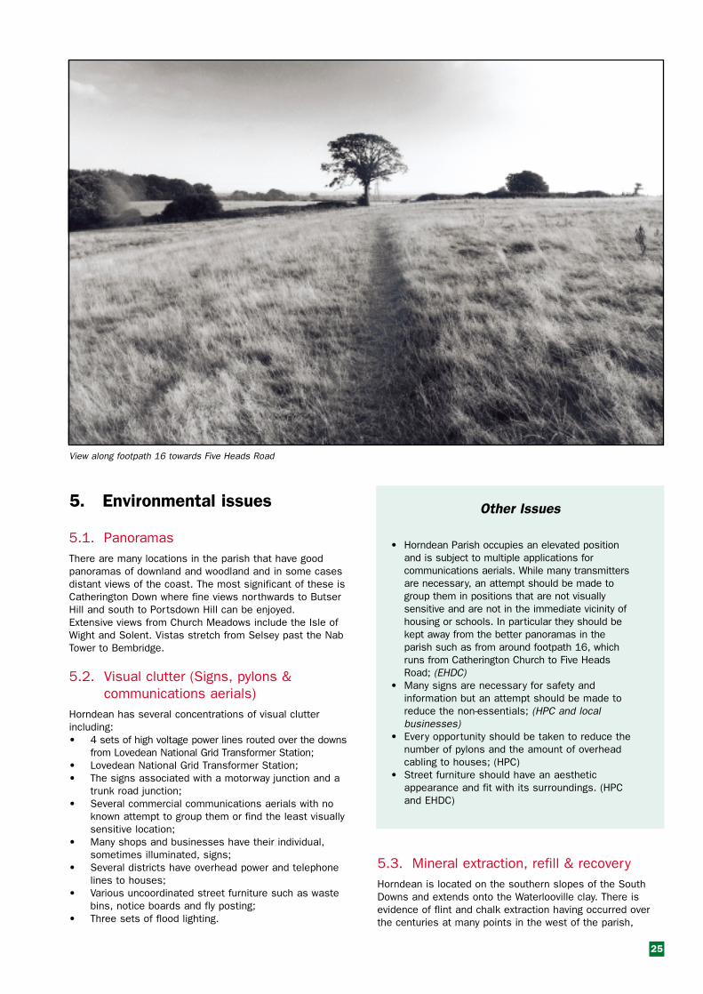
View along footpath 16 towards Five Heads Road
Other Issues
• Horndean Parish occupies an elevated positionand is subject to multiple applications forcommunications aerials. While many transmittersare necessary, an attempt should be made togroup them in positions that are not visuallysensitive and are not in the immediate vicinity ofhousing or schools. In particular they should bekept away from the better panoramas in theparish such as from around footpath 16, whichruns from Catherington Church to Five HeadsRoad; (EHDC)
• Many signs are necessary for safety andinformation but an attempt should be made toreduce the non-essentials; (HPC and localbusinesses)
• Every opportunity should be taken to reduce thenumber of pylons and the amount of overheadcabling to houses; (HPC)
• Street furniture should have an aestheticappearance and fit with its surroundings. (HPCand EHDC)
5.3. Mineral extraction, refill & recoveryHorndean is located on the southern slopes of the SouthDowns and extends onto the Waterlooville clay. There isevidence of flint and chalk extraction having occurred overthe centuries at many points in the west of the parish,

several of which are identified on the Ordnance Survey Map.There has also been a recent planning application to extractclay from Eastern Horndean and infill with rubbish. Close toFive Heads Road can be seen the remains of the old parishrefuse tip. There is evidence of several dells and swallowholes having been infilled. Beneath Horndean is acommercially worked oilfield with well heads in the east ofthe parish.
Other Issues
• Any proposals for opencast extraction of anyminerals are considered to be inappropriate inan area as densely populated as Horndean. Theconcerns include visual degradation of thelandscape, pollution from noise, dust andchemicals of residential areas either directly orfrom associated heavy vehicles and fromassociated health hazards. (HCC, EHDC andpotential developers)
5.4. Light pollutionLight pollution is an increasing irritant. It is caused by, brightlights on individual properties, flood lighting of sportscomplex’s and car parks, illumination of buildings, andstreet lighting. Glare can spoil the aesthetic appearance ofrural settings and lead to creeping suburbanisation. Theextent of the observable sky has, over the years, graduallydecreased, due to light pollution. An astronomical observatory of regional significance islocated in the west of the parish. If it was relocated it wouldbe a loss to the community.
26
Design Issues
• External lighting should be limited to theminimum required for security, safety andworking purposes; (EHDC, residents, propertyowners and developers)
• Light sources should be focused & screened torestricted light spillage; (EHDC, residents,property owners and developers)
• External lighting of buildings should be top down;(EHDC, residents, property owners anddevelopers)
• Street lights should be full cut off luminarieswith either flat glass or curved, temperedpolycarbonate. This reduces the upward lightspill without compromising effective groundillumination. (HCC, EHDC, HPC and developers)
5.5. Noise PollutionNoise levels have increased significantly over the last 15 years.There are concerns about the level of noise from the A3(M) andA3 and from noisy sports located to the east of the A3(M).
Other Issues
• Effective measures should be introduced toreduce the noise from the A3 and A3(M).Consideration should be given to tree screeningand low noise surfaces; (HCC and HPC)
• Noisy sports should be discouraged in areasadjacent to residential property. (EHDC and HPC)
Light pollution over Horndean

27
6. Roads, traffic and transport
6.1. The general pictureThe A3(M), keeps the majority of heavy and long distancetraffic out of Horndean Parish however residential roads andcountry lanes within the parish carry a substantial amountof traffic. Many of the population commute to work eithersouth to Portsmouth or the Solent growth area or north toPetersfield and beyond. The issue of transferring car journeys to other means doesnot seem to have been addressed and there is littleevidence of an integrated approach to transport. The builtup area of the parish has a cluttered appearance due to onroad parking and is experiencing increased congestion.
6.2. TrafficIn the 20 years following the opening ofthe A3(M) the traffic in the parish hasbecome heavier to the point at which ithas become difficult to join the A3 atpeak periods. The worst trafficbottleneck in Horndean Parish is at thejunction of Catherington Lane,Portsmouth Road, Dell Piece West andHazleton Way. At this point there is heavytraffic for a significant part of the dayand getting out of Hazleton Way andCatherington Lane can be difficult. Thejunction is considered by residents to bepoorly designed. The junction of London,Portsmouth and Havant Roads alsocreates a bottleneck. Parking in LondonRoad causes some of the problem.There are also concerns about trafficaround schools. Horndean TechnologyCollege has a travel to school plan,which has brought some benefit at leastin summer, but there is still a lot of roomfor improvement.
A(3)M
There are several concerns relating to proposeddevelopments abutting the Havant boundary. The primaryconcerns are the proposed housing developments at WecockFarm and Woodcroft Farm. Traffic generated from these siteswill feed into Horndean to access the A3 and A3(M).
6.3. CyclingThe terrain in the Parish of Horndean is good for cycling butit is discouraged by heavy traffic, a lack of cycle tracks, poorroad maintenance and a shortage of secure cycle parking.Horndean Technology College has been a pilot school in theSustrans national safe routes to school project and has atransport plan. Additional secure cycle parking has beenprovided and the number of pupils cycling to school hasdoubled but is still less than 5%. There are no continuouscycle routes and away from Horndean Technology Collegealmost no safe cycle parking is available.
Ham Lane

6.4. WalkingThe Parish of Horndean has an extensive set of footpaths,much of it through attractive woodland and downland. Theancient lanes of Crouch, Ham, Coldhill and Tagdell are all ina poor state of repair.
Horndean Junior School has a walking to school initiativethat has been hindered by poor footpaths. Significant routesfor pedestrians include stretches where they have to walkalong the carriageway and avoid oncoming vehicles.Horndean is not well linked into the network of long distancepaths, for example Monarch’s Way crosses the south of thevillage but it’s route is not signposted.
6.5. Public transportThere are bus services to Waterlooville, Portsmouth,Petersfield and Havant. There are also a small number ofexpress buses to London Victoria. All the local services arecomparatively slow with minimum times of 25 minutes toPetersfield (with some of the more strategic services taking35 minutes) and 20 minutes to Cosham & 40 minutes toCommercial Road also evening services are poor. Fewbuses connect at Petersfield with the fast rail services toLondon or at Cosham with Southampton and Bristol trains.Few buses use the fast routes along the A3 (M) and A3 butwander through adjoining communities. The proposal for buslanes in-between Waterlooville and Cosham, which may beextended, to Horndean is unlikely to provide muchimprovement for Horndean residents unless journey timesare significantly reduced and buses run when users requirethem.
Other Issues
The aims are that residents should be encouragedto travel by other means than by car and that thestate of the roads, byways and footpaths shouldenable them to feel free to enjoy walking and orcycling in the parish:• A direct, cycle route from Clanfield and North
Horndean to Horndean Technology College andSafeways and on to Waterlooville should beprovided; (HCC and HPC)
• Consideration should be given to identifying a setof strategic footpaths linking the settlements inthe parish. These should be maintained to astandard to allow all year use. This shouldinclude clearance from overgrowth, and safepassage when they follow or cross roadways;(HCC AND HPC)
• A review of how public transport could providerapid access to strategic points such asPortsmouth and Havant centres and Petersfieldand Cosham railway stations; (HCC and HPC)
• Developers should fund the cycle infrastructureaffected by and adjacent to their development;(EHDC)
• Schools should be encouraged to have transportplans, which are supported by district and countycouncils; (HCC and EHDC)
• More attention needs to be given to footpathsproviding through routes that link up with someof the long distance paths. (HPC and HCC)
28
Design Issues
• Secure cycle parking facilities should beavailable in places of work, shopping andentertainment. (Businesses in Horndean)

29
7. Commerce
7.1. Business and Industry The largest and most visible commercialproperties in the parish are a Safewaysupermarket, a large retail nursery and acaravan storage site off CatheringtonLane. The majority of the industry andcommercial property in the parish iswithin a narrow band along the A3(M) in-between Hazleton Interchange and LithAvenue. There are also several groups ofsmall industrial units, the LovedeanNational Grid Transformer Station andseveral waterworks installations. In London Road there is Gales Brewery, amedium sized brewery working in notablebuildings, immediately behind it is locateda curtain manufacturer and retailer.
There are a number of other shops andsmall businesses mainly located alongPortsmouth and London roads. Industry ismainly located in medium to small modernunits constructed over the last 30 years.
The access to and layout of most unitsis of a good standard. With the exceptionof the Post Office and a cash dispenserat Safeways there are no bankingfacilities in Horndean. It is difficult toassess the changes to Horndean thatwill result from the ‘e’ commercerevolution but there should beopportunities to grasp.
7.2. Commercial DevelopmentOver the past 40 years there has been a large amount ofhousing development in the parish without appropriate servicesand employment being available locally. This has resulted in alarge part of the community commuting, in many cases overlarge distances, resulting in the village developing mainly as adormitory. If the concept that business and industry is there toserve the community is followed, the present industry provides adegree of employment and opportunity but a large employmentdeficit remains.
The existing practice of containing commercial and businessdevelopment within the band along the A3(M) has obviousadvantages in that it makes good use of the land which ismost noise polluted and keeps much of the heavy traffic nearto the A3/A3(M).
The area to the north west of the A3 between Horndean PostOffice and the A(3)M looks neglected and although it occupiesa prime central position in the parish, it is underused andcreates a poor impression of the parish. There is a view thatthis area should be considered for redevelopment to provideshopping and or commercial services. If undertaken the designshould fit in with the traditional styles of Horndean Village.
Facilities built should be sufficiently adaptable to allowspecialist services to exist along side retail outlets and toallow the parish to benefit from opportunities resulting fromthe changing requirements of the population and the changesin technology such as ‘e’ commerce.
Safeway’s Supermarket
Safeway’s under construction
Industrial development off Portsmouth Road

Other Issues
• The existing practice of containing commercial andbusiness development within the band alongsidethe A3 (M) is supported and should continue as ithas obvious advantages in that it makes good useof the land which is most noise polluted andkeeps much of the heavy traffic near to theA3/A3(M); (EHDC)
• There should be consideration of the provision ofshopping facilities in the parish in particular withrespect to avoidance of a, “One shop town”. Ifthere is a lack of range of provision and limitedcompetition residents will travel to meet many oftheir needs, causing more congestion. (HPC,EHDC and local businesses)
7.3. Agriculture and its developmentThe local landscape today reflects farming activities over manycenturies and many of these farming activities are still much inevidence in the countryside around Horndean. Within the parishboundary there is a mixture of arable and pasture land. Mostfarmland has been managed on a small scale by local familiesand is reflected in the field patterns. Inevitably future changes infarming practices and land use may have a great effect on thelocal rural character of Horndean. County and district planningpolicies that will influence changes in land use will affect theparish. Horndean is particularly vulnerable because:a) There has been a very rapid spread of housing in the southleading to urbanisation. b) To the east and west of Horndean are Areas of OutstandingNatural Beauty that are proposed for inclusion in the NationalPark, while much of the village remains outside the nationalpark. This development is likely to put more pressure onplanners to find areas for development in Horndean and willmake it more difficult to protect open spaces of value that areoutside the park boundaries.Alternatives to traditional farming land uses should allow for thefuture needs of the local community and the rural character tobe considered. For example apart from a small area near NapierHall, there are no allotment facilities in Horndean Parish. Thiscould be a popular facility in the future. There is a growinginterest since new housing estates often have small gardenareas. With the ever-growing population there is a demand forspace for recreational activities. At present there are playingfields, a field for clay pigeon shooting and an area on the eastboundary used for car racing. On the southeast boundary isWaterlooville Golf Course and there have been suggestions ofcreating another golf course close to James’s Copse. A golfcourse would suite this location and form a break between thehousing and national park. It could act as a wildlife corridor toJames’s Copse and enhance the appearance of Lovedean.
Other Issues
• New recreational facilities located in the parishshould be environmentally friendly. There arelocations where a new golf course could meet theserequirements. For example there have beensuggestions that a golf course is constructed to thenorth and west of James’s Copse. Noisy sports arenot appropriate to, or in keeping with, a residentialarea. (HPC and EHDC)
30
Oil extraction rig
The Precinct
Enterprise Road
Horndean Post Office

31
Other Issues• Consideration should be given to creating a
‘Conservation Area’ in Blendworth (EHDC, HorndeanParish Council (HPC), Residents)
Catherington
Other Issues• New development of any kind in Catherington Village
should as far as possible be avoided; • In the wider Catherington area there is very little
scope for development without reducing theattractiveness of the area; (EHDC)
• It is recommended that Catherington Village is given‘Conservation Area’ status. (EHDC, HPC, Residents)
North Horndean
Design IssuesAround Viking Way, in the north of the estate, bungalowsare set on the crest of the hill and have a high profile. Ifany of these were extended into two storey dwellings, itwould spoil the appearance on the crest of the hill lookingwest. (EHDC and property owners)
Lovedean
Design IssuesFuture development or commercial activity should notremove or spoil the setting of the buildings forming thehistoric centre of the settlement. The ribbondevelopment along Lovedean Lane should be protectedfrom backland development up the valley sides.Development should only be undertaken on small, lowprofile sites, using materials and styles to complimentthe established village character and dissipate theeffect of traffic hence avoiding increased congestion inSouth Horndean. (EHDC)
Hazleton
Other IssuesThe large gardens in-between Rosemary Way, BriarClose and Portsmouth Road should not be used forinfill development as they provide a valuable andattractive gap between the main road and estate.(EHDC)
8. Recommendations and design guidelines
This section includes the recommendations and designguidance that the Horndean Parish Village Design Groupconsidered appropriate for future development andimprovement. The recommendations are structured under the followingheadings:1. Settlement pattern;2. Guidelines for building development in Horndean Parish;3. Horndeans Natural Heritage;4. Environmental Issues;5. Roads traffic and transport;6. CommerceThe VDS, and in particular the recommendations must beread along with the local plan and other current planningguidance. Guidelines, which relate to design are presented ona yellow background and have been adopted by the districtcouncil as supplementary planning guidance. Other guidelinesand proposals are presented on a green background.Indicated, in italics, at the end of each clause is the authority,body or group of people considered by the VDS group to beresponsible for making or promoting the improvement.
8.1 Settlement pattern
Horndean Village
Other Issues• Consideration should be given to redeveloping the
site to the northwest of the A3, in-between the postoffice and the A(3)M. The development should be inkeeping with the style of the conservation area andshould be planned to improve the appearance andvalue to the community of this site. The developmentappraisal should include consideration of the carparking needs of the village. The design should beflexible to encourage varied use and accommodatethe changing needs of the parish and of technology.(Responsible authority is East Hampshire DistrictCouncil. (EHDC))
Blendworth
Design Issues• With no local facilities, school or transport links and
served by minor roads, Blendworth is not suited tofur ther development. In-fill development orextensions should only be allowed where it does noteffect the setting of existing dwellings or thecharacter of the village. Those allowed should bebuilt to reflect the style and materials of theolder/original buildings rather than continue therecent trend of modern styles and finishes. (EHDC)

32
8.2 Guidelines for building development inHorndean Parish
Design Issues
Guidelines for redevelopment’s and alterations toexisting buildings
Almost every building whether old or new has at sometime been subjected to change. Changes may havebeen made to convert a building to fit the owners needsor tastes or to accommodate a change of use or thechanging needs of the time. Failure to modernise canlimit the usefulness of a building.If the character of an area is to be retained the followingguidelines for building redevelopment and alterationsshould be observed:• Materials, components and styling should be original
or of a sympathetic match to those on the existingbuilding; (EHDC and property owners)
• Redeveloped or altered buildings should be inproportion to and closely match the existing buildingand should not dominate or spoil the perspective ofthe surroundings; (EHDC and property owners)
• Existing hedges and trees should be retainedwhenever possible and the use of hedges asopposed to fences should be encouraged; (EHDC,HPC and property owners)
• Boundary walling and fencing in terms of height,width and suitable blends of materials should be inkeeping with the surrounding area; (EHDC andproperty owners)
• On more recent properties third storey developmentshould in most cases be limited to dormers thatretain existing rooflines. In the older areas suchdevelopments may be inappropriate; (EHDC)
• The conversion of front gardens to hard standing forthe purposes of car parking needs to be discouraged.This is primarily a feature of scale. There will be caseswhere an extra parking place can be fitted in withoutchanging the general appearance but the conversionof the whole of front gardens into parking lots candegrade the appearance of the immediate area andshould be discouraged; (EHDC and property owners)
• When adding security and communications devicesincluding external lighting care should be taken notto clutter the building or encroach on someone else’sdomain. (Property owners)
Guidelines for new construction
The following are points for consideration:• An attempt should be made to retain the style of the
area and where lost regain it; (EHDC, propertyowners and developers)
• There should be due consideration for safety. Forexample pedestrian access to new developmentsfrom local shops & services should not be acrossmajor roads; (EHDC and developers)
• Construction styles: New construction should be incharacter with its part of the parish. New buildingsshould be designed to reflect and respect nearbycolours, textures, materials shapes and styles andproportions. Styles traditional to the area such asflint faced or hung tile buildings and half hipped roofswould be appropriate in new developments; (EHDCand developers)
• The setting of listed buildings should be retained.(EHDC)
• Where a development includes low cost housingthere should be consultation at an early stage toensure that the low cost housing is of a similar styleand appearance to the rest of the estate. It shouldalso be ensured that the estate has been fullyintegrated to maximise the standard of life ofresidents; (EHDC and housing associations)
• A discouragement of flat roofing in favour of pitchedand tiled roofs would, in most parts of the Parish,enhance character;
• Hedges and trees: Existing hedges and trees should,whenever possible, be retained in newdevelopments. When trees are retained they shouldbe allowed room to develop to their full staturewithout putting surrounding buildings at risk. Newplantings of hedgerows should include a mix ofnative species that are characteristic of a largenumber of Horndean hedgerows and includehawthorn, blackthorn, hazel, field maple, ash andholly; (EHDC and developers)
• Informal open space, sports areas and associatedfacilities should be included in future developmentsto provide play areas within reasonable distance tothe residences. Open spaces should includefacilities for all age groups. (HPC and EHDC)
Commercial and industrial buildings
The following is suggested as a basic set of guidelinesfor the design of commercial and industrial buildingsthat might be constructed in the parish: • Buildings should preferably be used for purposes
similar to those for which they were designed,change of use can result in unsightly additions andalterations that spoil the outline and can damage thesurroundings. It would be better to find an alternativebuilding than to make unsightly changes;
• The colour and texture of the buildings should besympathetic to other local features;
• The building size, height, shape and external effectsshould fit easily on the site and not crowd out oroverlook adjacent areas. It’s use should not congestor obstruct the surrounding area;
• Peripheral requirements such as parking, servicingand deliveries should be addressed in the design;
• Screening should be to a good standard and wherepossible should use native trees and shrubs. Bothwinter and summer appearances should be considered;
• The type of activity in the building should beappropriate to its location, for example, wherecommercial buildings are close to housing, thereshould not be escape of noise, light or chemicalpollution. Where heavy vehicle access is requiredthey should be near to main roads;
• Business park type development may be best suitedto fit into the Horndean landscape;
• Unconventional designs should not be automaticallyrejected but their design should aim to enhance thearea;
• If the building is in a prominent position and cannotbe effectively screened, it should be constructed in alocally accepted style using materials similar to theexisting local buildings as indicated above. (EHDC,property owners and developers for all points in thissection)

33
• The length of built up boundary with Havant andClanfield should not be extended. Additionally openspaces between settlements should be maintainedto prevent Horndean from being absorbed in theWaterlooville suburban area. (EHDC and HavantBorough Council should be made aware of this concern)
8.3 Horndean’s natural heritage
Other Issues• Over recent years the local authorities have brought
several SINC’s into public ownership. This practiceshould be continued and if possible accelerated;(HPC, EHDC and Hampshire County Council (HCC))
• There are several small areas of ancient woodlandwhich, in the original classification of SINC’s, weretoo small to be considered but which considerablyadd to the appearance of the parish and should beretained. These include: Dell Piece Copse (East ofthe A3(M)), Coldhill Copse and Blendworth DownCopse (which already has a tree protection order)and possibly Ham Lane, Lychgate Copse (by thebridleway) and Lakes Copse; (HPC, EHDC, HCC andlandowners.)
• Farmers and landowners should be encouraged tomake more use of grants under the CountrysideStewardship Scheme for hedgerow and woodlandplanting initiatives and to improve the managementof hedgerows. Standard trees such as oak, ash andholly should be retained. Field margins should bekept and maintained; (Farmers and landowners,EHDC and HPC)
• Attempts to sub-divide open countryside into smallplots for the purpose of individual leisure or quasiagricultural purposes should be opposed. Thefragmentation has a negative effect on theappearance of the countryside. As an example it hastaken many years to recover the appearance ofCatherington Lith following such action. (EHDC andpotential developers)
8.4 Environmental Issues
Light Pollution
Design Issues• External lighting should be limited to the minimum
required for security, safety and working purposes;(EHDC, residents, property owners and developers)
• Light sources should be focused & screened torestricted light spillage; (EHDC, residents, propertyowners and developers)
• External lighting of buildings should be top down;(EHDC, residents, property owners and developers)
• Street lights should be full cut off luminaries witheither flat glass or curved, tempered polycarbonate.This reduces the upward light spill withoutcompromising effective ground illumination; (HCC,EHDC, HPC and developers)
Building materials
• The predominantly used building material inHorndean Parish is brick sometimes with flint orhung tile. There is some use of wood and or plasterfacing. On roofs, tiles are predominant but someolder buildings use slate. Many older houses haveornate bargeboards; (EHDC, property owners anddevelopers)
• Several older buildings in the parish, including anumber that are listed, use traditional brickwork andor tiles. Repairs and changes to these buildingsshould preferably use hand-made multi-stock clamp-fired bricks, hand made tiles of plain clay and limemortar for bonding. (EHDC and property owners)
Other Issues
Guidance for the retention of the appearance of the Parish
• If Horndean is to develop as a community and toremain a pleasant and attractive place to live, itmust have the services including entertainmentsappropriate to a parish of its size. To achieve thisspace needs to be kept in the central areas toretain the landscape character of the parish andalso for walking and development of services. Theopen spaces, which should be retained, are listedin appendix A3. In addition the space between theRoman Catholic Church and Portsmouth Road; theopen spaces in the Merchistoun Road Estate; andthe area around the ancient oak in the siteproposed for development in Havant Road shouldbe retained; (EHDC) and (HPC)).
• Future development should assist in balancingHorndean Parish around existing retail and otherfacilities;
• Facilities: Over the last 40 years the housing stockin the parish has been significantly increasedwithout the appropriate increase to facilities. Thisposition needs to be corrected prior to any furthersignificant housing development; (EHDC)
• There should be an attempt to segregate housingfrom un-neighbourly industrial and commercialdevelopments; (EHDC)
• Noise levels: Residential developments should onlybe permitted in areas with low noise levels; (EHDC)
• New construction should be kept away from visuallyattractive sites such as the remaining chalkdownland; (EHDC and developers)
• The issue of low cost housing often arises.Horndean does have some housing in this band butpossibly not enough. There has been someexpansion of low cost housing stock in recentdevelopments but the balance between this groupand more expensive housing needs to be monitoredcarefully; (EHDC)
• Consideration needs to be given to housing forolder members of the community. This includes,single storey housing, warden controlled andsuppor ted housing. At present there are asubstantial number of bungalows but there is alimited amount of other categories ofaccommodation for older people available and theposition needs continual monitoring; (EHDC andhousing associations)

34
Visual clutter (Signs, pylons & communication aerials)
Other Issues• Horndean Parish occupies an elevated position and
is subject to multiple applications forcommunications aerials. While many transmittersare necessary, an attempt should be made to groupthem in positions that are not visually sensitive andare not in the immediate vicinity of housing orschools. In particular they should be kept away fromthe better panoramas in the parish such as fromaround footpath 16, which runs from CatheringtonChurch to Five Heads Road; (EHDC)
• Many signs are necessary for safety andinformation but an attempt should be made toreduce the non-essentials; (HPC and localbusinesses)
• Every opportunity should be taken to reduce thenumber of pylons and the amount of overheadcabling to houses; (HPC)
• Street furniture should have an aesthetic appearanceand fit with its surroundings. (HPC and EHDC)
Mineral extraction refill & recovery
Other IssuesAny proposals for opencast extraction of any mineralsare considered to be inappropriate in an area as denselypopulated as Horndean. The concerns include visualdegradation of the landscape, pollution from noise, dustand chemicals of residential areas either directly or fromassociated heavy vehicles and from associated healthhazards. (HCC, EHDC and potential developers)
Noise pollution
Other Issues• Effective measures should be introduced to reduce
the noise from the A3 and A3(M). Considerationshould be given to tree screening and low noisesurfaces; (HCC and HPC)
• Noisy spor ts should be discouraged in areasadjacent to residential property. (EHDC and HPC)
8.5 Roads, traffic and transportThe aims are that residents should be encouraged to travel byother means than by car and that the state of the roads,byways and footpaths should enable them feel free to enjoywalking and or cycling in the parish:
Design Issues• Secure cycle parking facilities should be available in
places of work, shopping and enter tainment.(Businesses in Horndean)
Other Issues• A direct, cycle route from Clanfield and North
Horndean to Horndean Community School andSafeways and on to Waterlooville should be provided;(HCC and HPC)
• Consideration should be given to identifying a set ofstrategic footpaths linking the settlements in theparish. These should be maintained to a standard toallow all year use. This should include clearance fromovergrowth, and safe passage when they follow orcross roadways; (HCC AND HPC)
• A review of how public transport could provide rapidaccess to strategic points such as Portsmouth andHavant centres and Petersfield and Cosham railwaystations; (HCC and HPC)
• Developers should fund the cycle infrastructureaffected by and adjacent to their development;(EHDC)
• Schools should be encouraged to have transportplans, which are supported by district and countycouncils; (HCC and EHDC)
• More attention needs to be given to footpathsproviding through routes that link up with some of thelong distance paths. (HPC and HCC)
8.6 Commerce
Other Issues• The existing practice of containing commercial and
business development within the band alongside theA3 (M) is supported and should continue as it hasobvious advantages in that it makes good use of theland which is most noise polluted and keeps much ofthe heavy traffic near to the A3/A3(M); (EHDC)
• There should be consideration of the provision ofshopping facilities in the parish in particular withrespect to avoidance of a, “One shop town”. If thereis a lack of range of provision and limited competitionresidents will travel to meet many of their needs,causing more congestion; (HPC, EHDC and localbusinesses)
• New recreational facilities located in the parishshould be environmentally friendly. There arelocations where a new golf course could meet theserequirements. For example there have beensuggestions that a golf course is constructed to thenorth and west of James Copse. Noisy sports are notappropriate to, or in keeping with, a residential area.(HPC and EHDC)

35
Appendix A Supporting information
A1. Grade 2 listed Buildings
The current list of grade 2 listed buildings in HorndeanParish is as follows:
1 Hinton Manor House, Horndean;2 Cadlington House, Blendworth;3 Church of Holy Trinity, Blendworth;4 107, Pyle Lane, (Mouse Cottage), Blendworth;5 108, Pyle Lane, Blendworth;6 109, Pyle Lane,(Peppercorn Cottage) Blendworth;7 Hook Cottage, Blendworth;8 Gateway, forecourt paving and roadside boundary wall to
Hook Cottage, Blendworth;
9 Pyle Farmhouse, Blendworth;10 Barn 50 metres south of Pyle Farmhouse, Blendworth;11 Granary 20 metres east of Pyle Farmhouse, Blendworth;12 1 Ludmore Cottage, Broadway Lane;13 2 Ludmore Cottage, Broadway Lane;14 The Farmhouse, Catherington Lane;15 Granary 30 metres west of the Farmhouse;16 Catherington House (Kings Court School), Catherington
Lane;17 292 Catherington Cottage, Catherington Lane;18 1,2 & 3 Tudor Cottages, Catherington Lane;19 Church of All Saints, Catherington Lane;20 Barn at Nobles Farm;21 Red Lion Inn, Horndean;22 224 and 226, (Cottage) Lovedean;23 Merchistoun Hall, Portsmouth Road, Horndean;24 Milestone opposite 279 London Road, Horndean;25 Milestone opposite 178 Portsmouth Road, Horndean.
1
64
87
53
2
20
9
23
25
21
1415
16
17
1819
24
1213
22
Horndean’s Listed Buildings
Based upon Ordnance Survey mappingwith the permission of the Controller ofHer Majesty’s Office Crown Copyright.Unauthorised reproduction infringes CrownCopyright and may lead to prosecution orcivil proceedings. EHDC LA 078964 2002.
10 11

A2. Sites of Importance for Nature Conservancy (SINC’s)
The SINC’s within the parish are as follows:Prew’s Hanger;Ludmore Hanger/ Whitedells Copse;Crabdens Copse;Crabdens Row;James’s Copse & Outlier;James’s Copse Paddock;Rabbit Copse;Shuts Grove;Coombs Copse;Yeolls Copse;Catherington Lith;Stubbins Down;Blendworth Common;Redcroft Row;Blendworth Lith;Dell Piece West (subject to objection);Hazleton Common (Subject to objection);Dell Piece Gully (Subject to objection).
A3. Recreational, play and sports areas
The Parish Councils current list of recreational, play andsports areas is as follows:Young children’s areas - With play equipment or casual play
areas;Older children’s areas - Junior football pitches etc;Informal open spaces - Available to all for walking etc.
Young children’s areas:Deep Dell; Bentley Close;Quail Way; Wessex Road;Sheppard close; Hillside Close;Elmeswell Road; Kingsmead;Recreation Ground; Ashley Close;Munday’s Row; Lychgate Close;Stonechat Road; Merchistoun Hall.
Older children’s areas:Jubilee Fields; Recreation Ground;Horndean Campus;Old School Field, Catherington.
Informal open spaces:Dell Piece West;Hazleton Common (Local Nature Reserve);Yoells Copse (SINC);Catherington Lith (SINC & Local Nature Reserve);Recreation Ground;Catherington Lane Recreation Ground;Parsonage Field;Catherington Down (SSSI & Local Nature Reserve).
36
Appendix B Documents used for referenceduring the preparation of thestatementHorndean an outline history - Barry Stapleton, 2001.Horndean 2000 - Barry Stapleton.Horndean Conservation Area - East Hant District Council
1977.The Hampshire County Council Archaeological & History
Building Record, 2001.Hampshire Treasures - Hampshire County Council.Captain Swing - Eric Hubsbawm & George Rude’.Countryside Design Summary for East Hampshire. East
Hampshire District Council. June 1999.Draft documents prepared to support the preparation of a
Local Conservation Plan for Horndean.The following books have been used for guidance in building
terminology.How old is your house; Pamela Cunnington, 1999.Tracing the history of houses: Bill Breckon & Jeffrey Parker,
1991.
Appendix C Credits and ContactsPhotographs and maps used in this document are subject tocopyright as follows:Maps: The copyright statement for maps is indicated on thepage on which the map is displayed.Photographs used in this document have been supplied by;Garrick Palmer, John Vigay and Graham Bryant who retaincopyright of the photographs they supplied.The following have participated in the development of theVillage Design Statement.Mike Ashton John Creevy Hilary MunroPam Blake Stephen Harwood Garrick PalmerGraham Bryant John Kirk Pam PerkinsPeter Cave Tim May Barry Stapleton
John Vigay
For further information contact:“The Clerk” Horndean Parish CouncilTyfield House,Blendworth Lane,Horndean.Hants.PO8 0AA.This village design statement is also available onHorndean.net web site. It is intended that updates will beproduced when appropriate and that they are only publishedon the web site.
December 2002.

Jubilee Hall
Merchistoun Hall

Price £2 when sold but free to residents on application to parish office.
Printed by St. Richards Press Ltd., Leigh Road, Chichester, West Sussex PO19 2TU