Embed Size (px)
Citation preview

1 | P a g e
NEXUS Planning Address: 4/138 Siganto Drive, Oxenford, 4210
Phone: (07) 5562 0084 | Fax: (07) 5562 0088
Email: [email protected]
August 30, 2013
Dr Caryl Bosman
Ecoji Developments
Griffith University, Building G31, Science Road
Gold Coast, QLD, 4215
Attention: Dr Caryl Bosman
Dear Madam,
Enclosed is NEXUS Planning’s scoping and feasibility study for the 2018 Commonwealth Games
Village project as required by Ecoji Developments.
The study contains a detailed literature review; site, regional, city wide and local analysis,
appropriate planning legislative frameworks, statement of proposal, project risks, and
development funding, whereby a well-reasoned and coherent design for the Commonwealth
Games Village project could be established.
If you have any queries or further questions, please do not hesitate to contact me or any of the
staff at NEXUS Planning.
I look forward to hearing your thoughts regarding the proposed design.
Yours sincerely,
Ared Woskanian
Project Manager
2 | P a g e
NEXUS Planning
Scoping and Feasibility Study for 2018
Commonwealth Games Village
“The next generation of planning”

3 | P a g e
Executive Summary
The 2018 Commonwealth Games Village provides the opportunity to supply affordable medium to
high density housing, both during and post Commonwealth Games. In order to produce this
desired outcome, there will be an emphasis on urban ecological practices, transit oriented
development best practices and sustainable initiatives to create a benchmark development, for
the Health and Knowledge Precinct. This will be based off Southport’s demographic statistics,
confirming Southport as a desired location for the development proposal and through a literature
review of previous Commonwealth Game Village case studies.
NEXUS Planning concludes that providing affordable mixed-use development is crucial based off
current statistics within the region, considering Health and Knowledge Precinct infrastructure and
market trends alike. With a specific emphasis on transit oriented design principles that encourage
non-motorised transport options. These have been linked to strong community activity, resulting
in an increase of liveability in the local region.
The proposed site provides an opportunity to create a successful legacy development, and a new
hub for the Health and Knowledge Precinct. This is achieved by utilising the upcoming light rail
corridor and making use of its close proximity to arterial roads and University services. This will
provide the development with connections to outside infrastructure and services not located
within the development. The site contains some risks such as: pollution emitted from the
neighbouring motorway, noise pollution, obstructed drainage, increased traffic congestion and
preserving the essential habitat. However, these risks can be reduced through clever design
solution detailed within this report.
NEXUS Planning recommends that the development proposal go ahead, as it holds the potential to
achieve all key objectives outlined by Ecoji and become a profitable venture for their business. The
following report outlines how the development can achieve these objectives and be a successful
Athlete Village for the upcoming Commonwealth Games.

4 | P a g e
Contents Executive Summary ................................................................................................................................ 3
1. Introduction ................................................................................................................................... 7
1.1 Project outline .............................................................................................................................. 7
1.3 Context......................................................................................................................................... 8
1.4 Background................................................................................................................................... 9
1.5 Regional Analysis..........................................................................................................................10
1.6 Local Background .........................................................................................................................10
1.7 Stakeholders ................................................................................................................................12
1.8 Market analysis ............................................................................................................................13
1.8.1 Southport’s Social and Economic Profile ..................................................................................15
1.9 The Development Type .................................................................................................................15
1.9.1 Medium to high mixed-use development: ...............................................................................15
1.9.2 Mixed use (residential, commercial and retail) .........................................................................15
1.9.3 Separation of Uses .................................................................................................................16
1.10 Dwellings ...................................................................................................................................16
1.10.1 Tenant Mix and Dwelling Structures ......................................................................................16
1.10.2 Residential Dwellings:...........................................................................................................16
1.10.3 Commercial Dwellings: .........................................................................................................17
1.11 Parking ......................................................................................................................................17
1.12 Street types and cross-sections: ..................................................................................................18
2. Literature Review ..........................................................................................................................19
3. Site Analysis ..................................................................................................................................25
3.1 Soils.............................................................................................................................................25
3.2 Geology & Terrain ........................................................................................................................25
3.3 Aspect and Microclimate ..............................................................................................................27
3.4 Biodiversity ..................................................................................................................................27
3.4.1 Existing Flora Assessment .......................................................................................................27
3.4.2 Existing Fauna Assessment .....................................................................................................28
3.5 Noise ...........................................................................................................................................30
3.6 Flooding.......................................................................................................................................31
3.7 Air ...............................................................................................................................................31
3.4 Swot Analysis ...............................................................................................................................32
4. Planning Legislative Frameworks and Requirements .......................................................................32
4.1 Material Change of Use and Reconfiguration of the Lot ..................................................................34
4.1.1 Material Change of Use ..........................................................................................................34
4.1.2 Reconfiguration of the Lot ......................................................................................................34

5 | P a g e
4.2 Approval Times and Costs .................................................................................................................35
4.3 Compliance......................................................................................................................................35
4.3.1 Codes and Policies..................................................................................................................35
4.6 Planning Process Chart .....................................................................................................................36
5. Project Risks and Impacts...............................................................................................................36
5.1 Traffic ..........................................................................................................................................36
5.2 Parking ........................................................................................................................................38
5.3 Walkability ...................................................................................................................................38
5.4 Noise ...........................................................................................................................................38
5.5 Environment ................................................................................................................................40
5.6 Drainage ......................................................................................................................................41
5.7 Community ..................................................................................................................................41
5.8 Government and Finance ..............................................................................................................42
6. Statement of Proposal ...................................................................................................................43
6.1 Governance .................................................................................................................................44
6.2 Tenure .........................................................................................................................................46
7. Concept Plan .................................................................................................................................47
8. Recommendations .........................................................................................................................48
8.1 Site Recommendations .................................................................................................................48
8.1.1 Sustainability: ........................................................................................................................48
8.1.2 Transport Oriented Design:.....................................................................................................48
8.1.3 CPTED: ..................................................................................................................................49
8.1.4 Traffic:...................................................................................................................................49
8.1.5 Noise:....................................................................................................................................49
8.1.6 Environment: .........................................................................................................................49
8.1.7 Urban Ecology:.......................................................................................................................50
8.1.8 Community: ...........................................................................................................................50
8.1.9 Walkabilty: ............................................................................................................................50
8.1.10 Drainage: .............................................................................................................................50
8.1.11 Parking: ...............................................................................................................................51
8.1.11 Government and Finance:.....................................................................................................51
8.2 Liveability Post Commonwealth Games .........................................................................................51
8.3 Facilities During and Post Commonwealth Games ..........................................................................52
8.4 Marketability ...............................................................................................................................52
8. Project Development Funding ........................................................................................................53
8.1 Estimated Price: ...........................................................................................................................53
8.2 Profit: ..........................................................................................................................................54

6 | P a g e
8.3 Financial Arangments: ..................................................................................................................54
9. Conclusion .....................................................................................................................................55
10. Invoice.......................................................................................................................................56
10. References.....................................................................................................................................57
11. Appendices ................................................................................................................................66

7 | P a g e
1. Introduction
The Commonwealth Games will be held on the Gold Coast in 2018. In association with the games,
it is an integral part of the event to develop the 2018 Commonwealth Games Athletes Village as it
will accommodate and facilitate the 4,500 domestic and international athletes. Due to the
international recognition of the event, the development is an opportunity for the Gold Coast to
exhibit and create a benchmark development which has a lasting legacy. In light of this, the major
developers of the site – Ecoji, have sought consultation for the development of an ecologically
sustainable development (ESD) and highly marketable community village, which has an emphasis
on urban ecology practices and Transit orientated development (TOD) best practices. As a result,
NEXUS Planning was appointed to undertake a scoping and feasibility study for the 2018
Commonwealth Games Village (CGV) on the Parklands Showground in Southport, based on these
principles. The aim of the study was to analyse the existing environs of the site, identify physical,
financial and legislative challenges and recommend feasible and innovative solutions. The
recommendations outlined in this report will address the practical use of the development for the
event whilst also emphasising post commonwealth games liveability. The information gathered
from this study will feed into the Design Proposal and the Prelodgment and Development
Assessment report in the latter stages of the consultation process.
The Parklands Showground is located centrally within the major health and knowledge precinct in
Southport. The $1.2 billion dollar light rail corridor set to be opened in mid 2014 will run adjacent
to the site. The locality of the site to this major public transport corridor and amongst the
renowned institutions provides the opportunity for the development to become a new central hub
for Health and Knowledge Precinct, post Commonwealth Games.
1.1 Project outline
The project is to develop the Commonwealth Games Village (CGV), located at 1 Parklands Drive
Southport. The aim is to provide sustainable housing for 4,500 athletes throughout the
Commonwealth Games and provide local community members with a new central hub for the
Health and Knowledge Precinct, post Commonwealth Games.
A key objective of the Commonwealth Games Village is to become a legacy development. This will
be achieved through an innovative design based on the principles of sustainablility, Urban Ecology
and Transit Oriented Development (TOD) practices and elements of liveability. The design of the

8 | P a g e
development will address contemporary climate change issues through the implementation of
new and sustainable technology.
Figure 1.1: Surrounding features of the site
Source: Adapted from (Google Earth Pro 2008)
1.2 Context
Southport is to become the new Central Business District (CBD) for the Gold Coast (Zakazukha
2013). The South-East Queensland region is rapidly growing in terms of population and
infrastructure. By 2026 it is predicted the Gold Coast population will grow from 500,000 to over
800,000 residents, with an additional 50,000 – 60,000 visitors (Queensland Government 2013a). In
effect of this rapid growth, the Gold Coast has been undergoing development in the form of urban
sprawl heading north along the M1, through Coomera to Jacobs Well and Ormeau.
The development will become apart of the Health and Knowledge precinct, located within
Southport. The Health and Knowledge precinct is currently made up of Griffith University and the
Griffith University Hospital. Griffith University is predicting a rise in students and is expected to
exceed 25,000 by 2020 (Queensland Government 2013a). The newly constructed Gold Coast
University Hospital currently contains 750 beds. This demonstrates growth in activity within the
area. The Precincts purpose is to act as an integrated center for learning, innovation, knowledge,

9 | P a g e
and commercial services (Gold Coast City Council n.d.). It will become home to a number of
organisations representing technology, research, academia, government and support (Gold Coast
City Council n.d.).
Achieving the full potential of the Health and Knowledge Precinct will require the successful
integration of a range of relevant stakeholders to the area. This report outlines the vision,
development principles, strategies, and detailed recommendations for the development.
1.3 Background
The South East Queensland Regional Plan 2009 – 2031 identifies the Health and Knowledge
Precinct as a “Specialist Activity Centre” (Queensland Government 2009). Parklands Showgrounds
has been recognized as a Priority Development Area (PDA), and gives Economic Development
Queensland (EDQ) precedents of the initial development of the site. The EDQ have outlined a basic
layout for the site represented within Figure 1.2 below, and states that the Gold Coast City Council
(GCCC) will provide all trunk infrastructures for the site (Queensland Government 2013b). This also
provides a benefit of state infrastructure surrounding the investment, including the new Gold
Coast University Hospital and Gold Coast Rapid Transit System (RTS). It outlines improvements
which will be made to the transit development of the area and will improve access to the site and
relieve traffic congestion surrounding the site.
Figure 1.2: Concept plan
Source: (Queensland Government 2013b)

10 | P a g e
1.4 Regional Analysis
The Gold Coast is located only 78 kilometres from South Brisbane (Google Earth 2013). The Gold
Coast currently has a population of over 525,000 residents, providing 221,000 homes and 240,000
jobs (Profile.id 2013a). Within the next five years, expected trends for the area include: a growth
in the elderly demographic from 13 per cent to 19 per cent, and average house sizes declining
from 2.3 to 2.1 bedrooms (Profile.id 2013a). There will also be a strong focus towards TOD,
subsequently resulting in a reduction of private vehicle transportation dependency and a
reduction in parking demand (Profile id. 2013b).
1.5 Local Background
From 2006 – 2011, Southport population increased by more than 4,200 people, which is an
increase of 17.6 per cent, representing an annual growth increase of 3.3 per cent (Profile id.
2013a). Southport’s population rise is among the highest within the Gold Coast, demonstrating the
regions growth potential and the Parkland Showground’s ability to become a promising
investment.
Southport is predominantly high-density residential housing and commercial land use, with small
pockets of industrial sectors, as well as many open spaces and parklands for its community (Profile
id. 2013b). Southport will ultimately provide the principle business and economic growth for the
Northern Gold Coast (Queensland Government 2013a). Historically, Southport is one of Gold
Coasts earliest settlements and has been primarily the business, administrative and commercial
center for the Gold Coast ever since. The Rapid Transit Corridor (RTC) will run through the new
Southport CBD (Figure 1.3). This will assist in the continual growth of Southport, providing
community members access to work, and external facilities which are not currently provided by
the Health and Knowledge Precinct.
Major features within the Southport area include: Australia Fair, Gold Coast Institute of TAFE,
Griffith University, Gold Coast University Hospital, the Gold Coast Athletics Track, and the
Southport Aquatic Centre (see Appendix 1).
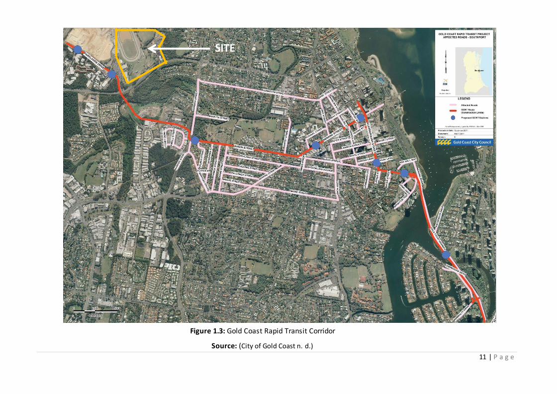
11 | P a g e
SITE
Figure 1.3: Gold Coast Rapid Transit Corridor
Source: (City of Gold Coast n. d.)

12 | P a g e
1.6 Stakeholders
The Commonwealth Games Village provides great opportunities for local residents and
stakeholders located within the region. Below is a list of the key stakeholders for the site:
Existing Parklands Showground Employees, Clientele and Customers
Gold Coast University Hospital
Nearby Businesses
International Commonwealth Games Representatives
Students Youths
Gold Coast City Council Regional Investors Local Community Members
National and Federal Governments Griffith University
NEXUS Planning is committed to involving all relevant stakeholders, to ensure their intrests are
protected in creating a legacy development for the CGV. Stiglitz identified that a development
represents a transformation in society (Stiglitz 1998, p. 19). For the CGV, this means the
integration of culture and the community is crucial. Therefore, the vital stakeholder to the success
of the development in becoming a legacy is the local community. Consequently, it is key to
understand what the community members find most important. Gail Connolly( Director of Gold
Coast City Council Planning Division) in a personal conversation on August 5, 2013 lists the top ten
concerns of the local community, outlined below:
It is NEXUS Planning’s goal to ensure that these concerns are addressed, as this will help the local
community to see the development in a positive light. It has been identified that key factors in a
successful development strategy include ownership and participation (Stiglitz 1998, p. 21). A
particular concern when evaluating the local community’s ownership towards the site is the loss of
the Parklands Showground. The Showgrounds are commonly used to host major events such as
the Big Day Out and the Gold Coast show. It also hosts smaller events such as caravan auctions
and local sporting events; therefore, the loss of the Showgrounds may create a negative outlook
towards the development.
1. Housing affordability
2. The right type of home
3. Great public transportation
4. A park for the kids
5. Connection. More jobs
6. Local schools and shops
7. Closer to where I live
8. Liveable neighborhoods
9. Shorter commutes
10. Hospital Accessability

13 | P a g e
0
5
10
15
20
25
30
35
Couples
with
Children
Couples
without
children
Single
parent
families
Other
familiesGroup
housholdLone
person
New urbanism, an initiative researched by Godschalk (2004), focuses on reestablishing the
relationship between buildings and the community through citizen based participatory planning.
Godschalk also links this connection with creating a successful legacy development.This is
important to focus on as this is Ecoji’s primary initiatives for the CGV.
All local community members will be involved within the key phases of the CGV project,
particularly lower demographics as Ghazala and Vijayendra (2004) identify that community-based
projects have not been effective at targeting the poor (Ghazala & Vijayendra 2004). This includes
notifying the community about project updates (giving the community a sense of ownership),
creating workshops such as planting tree’s, grand openings, information sessions, and using only
locally sourced resources to build the CGV. Therefore, this will create a sense of place and
ownership while bringing revenue to the area.
1.7 Market analysis
The following information was found based upon the Australian Bureau of Statistics market
research, and Gold Coast City Council statistics.
Southport has been a growing suburb since it was first established in 1874 (Profile id. 2013b). The
median age is 36 (Australian Bureau of Statistics 2006), and the composition of households is
predominantly single residents (30.4 per cent), followed by couples without children – illustrated
within Figure 1.4 below.
Figure 1.4: Household Composition
Source: (Profile id. 2013b)
Figure 1.4 above illustrates the household composition for the Southport region. These statistics
provide us with the family structure for the area, giving an understanding of which development
types would be appropriate to suit the CGV and the community’s needs.

14 | P a g e
Of the homes within Southport, 1.3 per cent are owned outright, 29.4 per cent are owned with a
mortgage and 44.8 per cent are rented. These figures suggest the development would be better
suited to provide a strong rental market as well as opportunities for home buyers. By selling off
part of the investment immediately post Commonwealth Games, an immediate return from the
investment can be achieved.
Household size in Australia has declined since the 1970s (Profile id. 2013b). However, between
2006–2011, the average household size remained stable for the nation as a whole (Profile id.
2013b). An increasing household size in an area may indicate a lack of affordable housing
opportunities for young people. Figure 1.5 below, represents an increase of single tenant
occupancy and a decrease in household size and household occupancy between 2006 – 2011. It is
seen that a declining household size indicates:
Children are moving out of home earlier
An increase in retirees settling in the area
An attraction of young singles and couples to the area (Profile id. 2013b)
This shows that there is a large population within Southport at present looking for a first home, a
home to retire in, small house size, as well as a good target for young and singe couples within the
area.
Figure 1.5: Tenant occupancy
Source: (Profile id. 2013b)
0
5
10
15
20
25
30
35
40
45
1 Person 2 Persons 3 Persons 4 Persons 5 Persons 6 Persons
Pe
rce
nta
ge
Number of household occupants
2011
2006

15 | P a g e
1.7.1 Southport’s Social and Economic Profile
As illustrated in Appendix 2, Southport’s personal weekly income by age group. The table shows
that the most common weekly income group as being between $400-599, as well as the most
common age bracket earning this amount as 25-34 year old individuals (ABS 2011). These income
and age statistics will be taken into consideration in order for NEXUS to provide reasonably priced
housing within the development. This development will mainly target this age and economic
demographic for the development, as it contains the largest portion of individuals within the
income bracket – providing suitable housing for the area.
1.8 The Development Type
1.8.1 Medium to high mixed-use development:
Mixed-use development has been outlined as the development type for the CGV. Mixed use
development provides the locals with a live, work, play community. Such types of development
have been demonstrated as key components for ‘Smart Growth’ and sustainable development
(Rabianski et al. 2009). Similarly, high density has been recognised as the most economically and
environmentally sustainable use of development, both in terms of reducing transport and
infrastructure costs (Choguill 2008, p.44).
Benefits and successful traits identified by the GCCC and Rabianski et al. (2009), have been
carefully considered in relation to the development of this mixed-use development – comprising
of residential and commercial/retail uses.
1.8.2 Mixed use (residential, commercial and retail)
Residential occupants create a demand for commercial and retail uses (Rabianski et al. 2009),
creating value for the uses and validating the incorporation of mixed-use. The integration of mixed
uses minimises the economic costs of time and effort for residents. This offers: a sense of place,
increased housing, employment and business investment choice to the wider public (Profile.id
2013a). Developer’s benefit from the integration of uses as tenancy rates can potentially be higher
as tenants can live, work and socialise in the same vicinity, minimising spatial separation. Risk for
the developer is also reduced, as this type of housing is open to a wider market (Rabianski et al.
2009).

16 | P a g e
1.8.3 Separation of Uses
Toit et al. (2007, p. 1697) identify how social interaction and a sense of community can be created
through spatial organisation. The differing uses within the development are spatially separated to
minimise possible noise pollution (Rabianski et al. 2009), as well as the implementation of
commercial/retail buildings adjacent to major roads, such as Smith Street Motorway, to further
minimise noise pollution.
1.9 Dwellings
1.9.1 Tenant Mix and Dwelling Structures
Based upon market research of the Australian Bureau of Statistics (2006; 2011) and Gold Coast
City Council statistics, NEXUS were able to properly assess and identify the target market of the
development, along with the dwelling structures.
Investors will be drawn to the development through the provision of affordable housing
structures. The development is designed to provide housing to accommodate the large number of
renters made up primarily of familes (over 48 per cent) within the Southport region. This is the
predominant housing structure; however, there will be a portion of the CGV which will be
developed to attract singles and share house accommodation (30.4 per cent). With Griffith
University located in very close proximity , there will be a large market of students looking for
housing close by and this will be provided in the form of shared accommodation.
As these demographic structures comprise the largest portion of market share, they confirm
Southport as an attractive and desireable living destination, signifying a great demand for this type
of housing. As there is already popularity existing in this area for these market sections, it would
be unjustifiable to target another, smaller segment. In extension, couples with children will be
drawn to, and benefit from, the proximity to education facilities and recreational parks. Whilst
childless couples are presumably looking to ‘settle down’ in areas where they can begin families,
and as such, require and obtain the same benefits as that of couples with children.
1.9.2 Residential Dwellings:
It is proposed that 7 residential buildings comprising of 1,800 apartments will be built to
accommodate the 4,500 Commonwealth Games athletes and officials, and post-games residents.
This conclusion was reached due to the following:

17 | P a g e
Recent studies revealed resident approval of medium-high density living, being that 58 per
cent of people appreciate lower levels of maintenance and the concept of ‘ready-made’
and master planned dwellings (Baker 2011; Choguill 2008).
Renters can be drawn to the affordability element of apartments, rather than separate
houses.
1.9.3 Commercial Dwellings:
As outlined within concept plan, it is proposed that there is to be 2 commercial/retail buildings
located along the Smith Street Motorway. Tenants such as a convenience stores, doctor practices,
chemists, etc. will be encouraged to integrate with the residents’ general necessities and leisurely
desires. The commercial development will also be apart of the mixed-use layout located within the
center of the development, along with the road, to encourage the use of the facilities by residents
and ease the flow of traffic.
1.10 Parking
Herman Knoflacher (2006) reviews the failure of conventional transport policies to address the
many issues that arise through private car ownership, within high-income cities. It is necessary for
iconic developments such as the CGV to pave the way and reduce the demand on motor vehicle
transportation through TOD design initiatives. With less focus on motor vehicle design, and more
focus on buses, light rails, bicycle riding and walking (table 1.1 below), we can improve the quality
of life for residents and the economic value of the area – saving both the developers and residents
money.
Table 1.1: Method of travel to work
Southport 2011 2006
Method of Travel Number Per cent Number Per cent
Train 93 0.8 97 0.9 Bus 579 4.8 430 4.1
Car – as driver 6,916 57.2 6,039 57.3 Car – as passenger 753 6.2 699 6.6 Motor Bike 139 1.1 104 1.0 Bicycle 205 1.7 168 0.9 Walked only 1,043 3.1 837 3.1 Other 196 1.6 106 1.0
Source: (Profile id. 2013b)

18 | P a g e
Within the development, some of the residential apartment buildings will supply private,
underground parking for residents to utilise. Residents in high density dwellings have the choice
between shared undercover parking (secure), or apartments without parking provided. The ability
of residents to access services and employment are influenced by their accessibility to transport.
In Southport 42.7 per cent of occupied private dwellings had one registered motor vehicle
garaged or parked at their address, 24.6 per cent had two registered motor vehicles and 7.7 per
cent had three or more registered motor vehicles (Profile id. 2013b). This has increased
substantially since 2006, demonstrating the lack of strong TOD developments within the region. As
the future LRC, mixed-use development and necessary infrastructure are within close proximity to
the development, residents within the CGV will be an exemption to this trend of high vehicle
dependancy. A section of the CGV apartments will not be providing parking in order to reduce
current demand for motor vehicles and put more attention towards walkability, cyclability and
public transport options. Within the development, commercial/retail visitor parking will be
provided and located adjacent to the building, in a separate lot.
1.11 Street types and cross-sections:
It was put forth by the EDQ that a major road be placed through the middle of the development,
with an adjoining road giving access via parklands drive (figure 1.2). Lawrence et al. (2001, p. 23)
identifies that ‘rarely does non-motorised transportation techniques occupy a central focus on
travel behavior and land development’. It has been proven that the built environment can
encourages or discourages physical activity (Lawrence et al. 2001). Therefore, it is important that
the streets within the development provide walkability, cycle movement, and maximise shared
road use design techniques, all of which have been linked to substantial health gains of residents
within the local community as outlined by Saelens (2013, p.13). The sections shown below gives a
guide to the role in which each street will play in the overall development.

19 | P a g e
Figure 1.6: Street design
Source: (Ottowa n.d.)
2. Literature Review
The 2018 Commonwealth Games is a development of great significance for the Gold Coast and
Australia alike. There are many factors which need to be accounted for to achieve a successful
outcome for this project. This literature review will examine four factors which are pivotal to
creating a benchmark ecological sustainable development for the village. Factors addressed are:
sustainability principles, urban ecological principles, transit orientated developments, and case
studies relevant to the development of Commonwealth Games Village project.
2.1 Sustainability
Sustainability principles which are to be incorporated in the design for the 2018 CGV need to
consider a range of factors. Sustainable development seeks to fulfil l criteria of environmental,
economic, and social factors also known as the triple bottom line (Hediger 2000; Kaygusuz 2009;
Coffman & Umemoto 2010; Govindan et al. 2013).
Environment – green space: Due to increased urbanistation around the world there is a decline in
green space areas within urban environments. Ward et al. (2010) identifies that preserving and
creating these spaces is crucial for creating an urban community that is environmentally
sustainable. Additionally, Ward et al. (2010, p. 49) suggests the implementation of botanical
gardens as a method of sustainability, due to the multitude of social and environmental benefits it
can have within an urban environment of: a place for psychological, health and aesthetic
purposes; the purification of water and air, filtration of wind and noise, a place for habitat

20 | P a g e
provision, and a method for the stabilisation of microclimates. Additionally, Cervero & Sullivan
(2011, p. 210) also discuss how the integration of bioswales, recyling and reusing construction
materials, as well as the reuse of land can significantly lower the detrimental affect on an
environment. Greenspace is important when creating new urban areas. Bruning (1991, p. 18)
mentions that the integration of ecological principles when designing and rebuilding towns and
cities is a significant way to counteract detrimental effects to the environment.
Environment – building design: Due to the onset of detrimental effects to the environment from
buiding developments, environmental sustainability measures must be taken into account when
designing the 2018 CGV. GhaffarianHoseini (2012, p. 36) identified nine critical design principles
when accounting for ecologically sensitive design within an area. These include: design integrated
with the environment and ecosystem present; conservation of matter, energy and ecosystems;
consideration of present ecosystem’s relationship with other ecosystems ; optimisation of physical
and natural features; consideration of the designs impacts over its life time; consideration of
energy impacts; holistically-based design instead of fragmented design; consideration of the
present ecosystems capacity for human-induced waste; and a responsive and anticipating design
with the greatest benefit to surrounding natural systems (GhaffarianHoseini 2012, p. 36). Cervero
& Sullivan (2011, p. 211) noted that the utilisation of the suns renewable energy can be
implemented through solar pannels within a TOD. Another method which can minimise
environmental degradation and is seen to be the foundation of a green development, is passive
design (Hampton 2011). Passive design seeks to provide a comfortable temperature within a
building through the utilisation of the suns energy – instead of mechanical measures – for three
main energy saving design principles: solar orientation, insulation, and ventilation (Cole 2011).
Litichevskaya (2011, pp. 64-65) identified that the integration of rooftop gardens can also lower
temperatures and reduce the need for heating and cooling of a building, and improve air quality.
Moreover, rooftop gardens can also reduce a buildings overall energy consumption (Wong et al.
2003; Skinner 2006). A further method of environmental sustainability is the implementation of
permeable paving. Scholz & Grabowiecki (2007, p. 3831) identify permeble pavement to be
sustainably beneficial due to being cost effective in urban areas, reducing runoff, recharging
ground water, and preventing water-based pollution.
Economic: Economic sustainability is critical for the successful completion of a sustainable
development. Baumgartner & Quass (2010, p. 446) define the concept of economic sustainability

21 | P a g e
as the non-wasting of scarce resources to meet the needs of humans, whilst maintaining a sense
of justice between future and present generations, and upholding justice between humans and
the environment for the future. Choguill (2008, p.44) suggested that a method for economic
sustainability for a sustainable development can be achieved when the size of the development is
limited, but the densities are high (combatting urban sprawl). Pitt et al. (2009) and Levin (2013)
identified affordability as one of the prominent barriers to construction of a sustainable
development. Though sustainable housing may be more expensive upfront than other dwellings of
similar location and size, in the long run sustainable housing offers direct economic benefits to the
owners – due to it’s energy and money saving techniques (Levin 2013). This illustrates that while
short term expenditure is necessary, the long term benefits, both economically and
environmentally are evident.
Social: Sustainable development, in a social aspect, is: “a development that meets the needs of the
present without comprising the ability of future generations to meet their own needs of needs”
(World Commison on Environment and Development 1987, p. 43). On this, Bijl (2011, p. 162) notes
that citizen-oriented features, such as: a sense of community, safety, and community engagement
are key to social sustainability. Dempsey et al. (2011, p. 297) also recognised that the safety of a
community is a fundamental element of social sustainability. Therefore, the integration of the
Queensland Government’s (2007) ‘Crime Prevention Through Environmental Design’ (CPTED) into
the proposed CGV is imperative in order to ensure resident safety. Dempsey et al. (2011, p. 293)
also found that social equity is a major component of social sustainability in a community, where it
is seen that no exclusion or discrimination within a community exists. Additionally, Trudeau (2013,
p. 434) also identifies that equal accessibility amongst residents to essential services, employment,
transportation, and housing is a vital aspect of social sustainability. In accordance with this,
methods to incorporate the elements of social sustainability discussed above can be seen in the
statement of proposal section.
2.2 Urban ecology
Urban ecology is a relatively new interdisciplinary field of social and ecological sciences (Young
2009; Lascar 2012). It is difficult to accurately define the concept of urban ecology (Niemela 1999,
p. 121). However, it can be understood as the study of relationships of the physical environment
(place) and its inhabiting organisms; as well as the occupation, utilisation and management of said
physical environments; and the interaction of humans and place, in regards to leisure/recreation
22 | P a g e
and movement (Lorimer 2012, p. 24). Urban ecology has become an increasingly important field
due to rapid urbanisation (Niemela 1999; Zhao et al. 2010; Singh & Singh 2011; Zhu et al. 2011;
Ramalho & Hobbs 2012; Zhu 2012).
Urban Ecology Australia Inc (2013) identifies succesfully developing an ecocity as a goal of urban
ecology. Similarly, Breuste et al. (2008, p. 1139) discussed how approaches to minimise
environmental harm may include the development of sustainable cities. An ecocity (sustainable
city/development) can be understood as a development where ecological impacts are minimised,
aesthetic and functional balance between landscape and built-form is found, and buildings are
safe and efficient in the use of resources (Urban Ecology Australia Inc. 2013). Architect Paul
Downton proposed 10 principles which must be met when planning an ecocity development:
restore degraded land, fit the bioregion, balance development, create compact cities , optimise
energy performance, contribute to the economy, provide health and safety, encourage
community, promote social justice and equity, and enrich history and culture (Ecopolis Architects,
n.d.). These critical features of an ecocity are examined further in the sustainability section below.
An example of a development which covers these criteria in an exemplary manner, is the Christie
Walk development, Adelaide, Australia (Urban Ecology Australia Inc, 2013). This development
shows envrionmental and social-based features which are desirable when developing the Gold
Coast Commonwealth Games Village.
2.3 Transit Oriented Developments
Numerous studies (Boarnet & Compin 1999; Renne 2009; Duncan 2011) define transit oriented
developments (TOD) as developments which are: located within an 800 metre (10 minute) walk of
a major transit station, pedestrian friendly, comprised of mixed-use buildings, and ensure public
transportation connectivity through innovative urban design. Furthermore, within TOD based
research it is seen that the reduction of automobile transportation dependency and land-use
efficiency are two very interrelated topics which are commonly addressed.
One of the key objectives of a TOD is to seek the reduction in car dependency, as successful
implementation can result in a large range of benefits. Olaru et al. (2011, p. 220) acknowledge that
the integration of the standard elements of a TOD – mixed land-use, high-density residential and
commerical developments, and public transport connectivity – contributes to a reduction in car

23 | P a g e
dependancy. Bezler and Autler (2002), and Shelton and Lo (2003) determined that TODs can allow
for the improvement of current environmental conditions, through reduced reliance on fossil fuels
(from personal motor vehicle transportation) and therefore reduce air pollution. Cervero and
Sullivan (2011) also discussed how TODs lower car dependancy, however, they also suggested that
the implementation of a synergy between a regular TOD and green urbanism, known as a green
TOD, be undertaken. A reduction in energy consumption by up to 30 per cent and lowered carbon
emissions are among the extensive range of benefits that a green TOD would provide (Cervero &
Sullivan 2011, p. 217). Boarnet and Compin (1999), Loo et al. (2010), and Li et al. (2010)
acknowledged that residents who live within a TOD are more likely, up to five times more, to
utilise public transportation compared to people who do not reside within a TOD neighbourhood.
Another method of reducing car dependancy and subsequent detrimental impacts identified by
Cervero and Sullivan (2011, p. 211) is the implementation of a bike sharing initiative within a TOD.
Efficiency of land-use within a TOD is another feature which is pivotal to consider for the design of
the 2018 Gold Coast Commonwealth Games Village. Renne (2009) and Curtis (2012) identified that
the implementation of high-density residential development within a TOD is suggested in order to
further support the use of public transportation, as higher densities allow for improvements of
overall resource-use efficiency (Cervero & Sullivan 2011, p. 210). Curtis (2012, p. 276) elaborated
on the concept of mixed use in TODs, stating that the idea is to have high-density residential and
office/commerical development located within close proximity to a transit station in order to
support use of public transportation. On this, Bailey et al. (2007, p. 236) noted that as well as
providing a transportation hub, the overall liveability of communities and neighbourhoods can be
improved upon by a TOD.
The Environmental Protection Agency (2009) identify features of a liveable city which TODs can
provide as: mixed-land use to encourage walkability, a variety of housing types, a greater sense of
community, and pride of place. Cervero and Sullivan (2011, p. 211) also identified that the
inclusion of mixed-use land uses can also invite more walking and cycling within a TOD. They
(Cervero & Sullivan 2011; Zullo 2011) further recognised that surface parking within a TOD can be
reduced due to the availability of high quality transportation, especially when successful
implementation of a pedestrian friendly environment occurs. It was also acknowledged by the
Queensland Government (2010, p. 3) that another significant benefit of a TOD is an increase in

24 | P a g e
levels of affordable housing. Therefore, due to their associated benefits, the optimisation of land-
use efficiency within a TOD will be integrated into the 2018 Commonwealth Games Village.
2.4 Case Studies
Case Study 1 – Glasgow Commonwealth Games Village (2014):
The 2014 Glasgow Commonwealth Games Village is of particular interest as it is the precursor to
the 2018 Gold Coast Commonwealth Games. The Glasgow village is also relevant to the design of
the 2018 Commonwealth Games Village, as it seeks to incorporate sustainable elements which
help to create a low carbon emission development.
The design of the Glasgow Games Village has been noted to include 700 future homes, and 6,500
beds (Glasgow 2014 n.d.), allowing for the housing of up to 8,000 people (RMJM 2013).
Sustainability will be implemented through the re-cycling of materials, such as 260,000 furniture
items obtained from the 2012 London Olympic and Paralympic Games will be used. Additionally, a
minimum of 10 per cent recycled materials will be used for the construction of the village (RMJM
2013). Energy-efficiency is also accounted for in the village through the integration of renewable
energy methods. Renewable energy facilities, located on site, will produce 10 per cent of the
villages overall energy requirements, therefore helping enforce its environmentally sustainable
design (RMJM 2013). Lastly, the dwellings which were used to house the athletes will be
retrofitted post-games and sold off.
Case Study 2 – Christie Walk:
Christie Walk in Adelaide, Australia, has measures of sustainability and a strong sense of
community integrated into its design, which is relevant and desirable for the 2018 Gold Coast
Commonwealth Games Village, particularly for post-games.
The urban community of Christie Walk consists of 27 homes and various gardens, where the goal
was to create a liveable, affordable and environmentally friendly village to house approximately 40
residents (Urban Ecology Australia Inc 2013). In order to meet these goals, Christie Walk sought
the implementation of five environmental performance criteria which were used as guidelines for
the design of the community: energy, water, land, health, and pollution. For these criteria to be
met, sustainability measures were to be integrated. Some of the key methods of sustainability for

25 | P a g e
the Christie Walk community were: good solar orientation, passive design (ventilation and
insulation), rooftop gardens, and use of recycled materials (Downton 2006).
3. Site Analysis
This section of the report will analyse the context of the site in relation to both its surrounding and
existing physical features.
3.1 Soils
The soil on the site is safe to develop upon, as there are:
No acid sulphate soils (Gold Coast City Council 2003a)
No unstable soils or areas of potential landslips (Gold Coast City Council 2003b)
Hydrosol soils - which are the primary soil type on the site (Department of Natural
Resources & Mines 2010).
Hydrosol soils are typically located near coastal areas and are the most dominant soil type on the
Gold Coast (Department of Natural Resources & Mines 2010). The soil is typically characterised
with longer periods of water saturation which is seasonal or permanent – the soil remains
saturated for up to 2 to 3 months per year (Department of Natural Resources & Mines 2010).
Hence, hydrosol soils are quite fertile but are susceptible to water logging if there is poor internal
drainage within the area (Department of Primary Industries n.d.). Hydrosol soils also have a high
clay content and are therefore less likely to erode (Department of Primary Industries 2009, p.
151).
3.2 Geology & Terrain
The topography of the site consists of
mainly hills and flatlands. As the current
terrain has been altered to accommodate a
harness racing track and its corresponding
facilities, the flattest section of the site is
the track area. The track area has a
consistent elevation of 10 metres
(Google Earth Pro 2008) above the
Figure 3.1: Harness Race Track
Source: NEXUS Planning 2013

26 | P a g e
Figure 3.2: The main building
Source: NEXUS Planning 2013
Figure 1.3 Asphalt coverage
Source: NEXUS Planning 2013
Australian Height Datum (AHD), and is the lowest point on the site. The hill to the west of the
track has an elevation range of approximately 20 to 25 metres (Google Earth Pro 2008) AHD, and is
the highest elevation point on the site.
The general topography of the site slopes from the west to the east. The large hill in the west
gradually plateaus into flat terrain and smaller hills in the east. There are also smaller hills located
in the southern area of the site behind the track. Within the centre of the track is also a catchment
pond which is approximately four metres in depth. The catchment pond covers approximately 5
per cent of the land while 46 per cent of the land is covered by asphalt and gravel. The asphalt and
gravel has the largest coverage on the site. Open space covers 42 per cent of the site and only 7
per cent of the site is covered by infrastructure.
The site lies within a regional ecosystem which is
characterised by tall and open Eucalyptus forests
which overlay metamorphic and interbedded
volcanic rock (Department of Environment and
Heritage Protection 2013a).
Metamorphic rocks are stable and create an ideal
foundation for development to take place on – as they
are used extensively to create building and
construction materials (Schultz 2012, p. 6).
However, due to the modification of the land, there
is little to no forest cover remaining on the site. The
site has a zero to low bushfire susceptibility rating
(Gold Coast City Council 2003d). Additionally, there
are small fragments of land on the site which have
been identified as having a low likelihood of bush
fire occurrences (Gold Coast City Council 2003d).
These areas include a small section of the endangered
regional ecosystem which protrudes onto the site
from the north-east. The second location which has a low bushfire susceptibility is located near
the centre of the site (Gold Coast City Council 2003d). Around the eastern exteriors of the site

27 | P a g e
there are also forest areas which have a medium bushfire susceptibility rating (Gold Coast City
Council 2003d).
3.3 Aspect and Microclimate
The site has an easterly and north easterly aspect. Due to the orientation of the large western hill,
solar access for this area is greatest in the mornings. There is no hill shade created on the
opposing side as the elevation of the land increases towards Parklands Drive.
Several shaded microclimates exist near areas which have a high density of tall eucalyptus trees. In
particular, an area beside the endangered regional ecosystem has restricted solar access due to a
higher density of tall trees. As a result, the climate is noticeably cooler and the ground is saturated
and moist, whilst the conditions outside this shaded area are dry and hot.
3.4 Biodiversity
It has been identified that a total of 97 species of animals and plants exist within a one kilometre
radius of the site (Department of Heritage and Protection 2013b). As the site is partially
surrounded by open forests, there is an abundance of biodiversity nearby.
3.4.1 Existing Flora Assessment
The site contains a section of remnant
vegetation which is classified as an endangered
regional ecosystem (Queensland Government
2012a). The endangered regional ecosystem
exists in the north eastern portion of the land,
and consists of mid to dense Eucalyptus
pilularis open forest more commonly known
as Blackbutt (Department of Environment
and Heritage Protection 2013a). This means development is prohibited to take place on this area,
as it must remain protected. The endangered ecosystem occupies 2 per cent of the site and is
approximately 0.60 hectares in size (6000m²) (Google Earth Pro 2008).
There are fragments of vegetation classified as bushland mosaic which border the eastern, south-
eastern and southern boundaries of the site (Gold Coast City Council 2003). The bushland mosaics
are conservation areas which can be developed, but it is recommended that they are left
Figure 3.2: Remnant vegetation
Source: NEXUS Planning 2013

28 | P a g e
remaining or are sensitively developed, as they are often ‘stepping stone’ habitats for a diversity
of fauna (Gold Coast City Council 2011a, p. 2). The bushland mosaic vegetation is sparse, but links
to the external forest east of the site.
Vegetation on the land is minimal even though there is a vast amount of open space. The open
space areas are predominantly covered by perennial grass and tall native trees. The trees on the
site are scattered in various densities around the perimeter of the site. Majority of the trees on
site are mature, with heights ranging from 10 to 20 metres.
No individual species of plants have been identified to have a concerning wildlife status
(Department of Heritage and Protection 2013b).
3.4.2 Existing Fauna Assessment
The endangered regional ecosystem is classified as an essential habitat (Queensland Government
2012a) and serves as a fundamental habitat for the endangered fauna on the site. Development is
prohibited to occur on the essential habitat as it contains the mandatory habitat conditions which
the protected species require to survive. Three species with a concerning wildlife status have been
identified to potentially exist within the essential habitat or anywhere within one kilometre of the
subject site. These animals include:
Green thighed frog
Wallum froglet
Koala (Southeast Queensland bioregion)
Figure 3.4: Perennial Grass cover
Source: NEXUS Planning 2013
Figure 3.3: Existing infrastructure
Source: NEXUS Planning 2013

29 | P a g e
Table 3.1: Animal species that have a concerning wildlife status which can potentially exist within the endangered regional ecosystem on site
Animal Species
State Listed Status
(Queensland Nature
Conservation Act 1992)
Federal Listed Status
(Australian Environment
Protection & Biodiversity
Conservation Act (EPBC)
1999)
Green thighed frog
(Litoria brevipalmata)
Near threatened
Least concerned
Wallum froglet
(Crinia tinnula)
Vulnerable
Least concerned
Koala
(Southeast Queensland
bioregion)
(Phascolarctos cinereus)
Vulnerable
Vulnerable
Source: adapted from (Queensland Government 2012a; Australian Government 2009)
The Grey headed flying fox is also identified to exist within one kilometre of the site and is
identified by the Queensland Government to be vulnerable (Department of Heritage and
Protection 2013b). However, this specie does not require the conditions of the essential habitat on
the site in order to survive.
As seen in Table 3.1, Koala’s are identified as ‘regionally vulnerable’ in the South East Queensland
(SEQ) Bioregion (Department of Environment and Heritage Protection 2012). Outside of this area,
Koala’s are listed as ‘least concerned’ in Queensland, but are still protected nationally
(Department of Environment and Heritage Protection 2012). Due to location of the site within SEQ
and the vast amount of Eucalyptus pilularis open forest which occurs within the essential habitat,
it is likely Koala’s will inhabit the endangered regional ecosystem.
During the site inspection, it was also noted that the shaded microclimate located next to the
endangered regional ecosystem was thriving with fauna. Many bird species such as ducks, magpies
and native cockatoos were seen foraging on the ground within this area.

30 | P a g e
3.5 Noise
The primary noise source to the site is from the surrounding road traffic noise. The Smith Street
Motorway, Parklands Drive and Olsen Avenue neighbour the site and generate varied intensities of
road traffic noise. The Smith Street Motorway produces the highest intensity of road trafficked
noise as it is within 15 metres of the sites boundaries and is a major arterial road. Parklands Drive
is also within 15 metres of the sites boundaries, and produces medium intensities of road traffic
noise as it is a minor road. Addtionally, it is still utilised heavily by students and faculty during the
day within the operating hours of Griffith University. Olsen Avenue is a main road but is located
700 metres (Google Earth 2003) from the sites boundaries to the northwest. Due to this large
proximity gap from the site, the road traffic noise from Olsen Avenue only creates a light hum - as
noted during the site inspection. Traffic noise can become a serious issue for residents if it is
occurring within 500 feet (approximately 150 meters) of their homes (Washington State
Department of Transport n.d.). The following table displays the decibels of sound produced by
different vehicles and traffic conditions which are likely to be experienced around the site:
Table 3.2: The sound intensities of various types of vehicles and traffic conditions
Noise Source Sound intensity (dBA)
Heavy Truck or Motorbike at 80km/hour
(Hopper 2013, p. 1)
90 decibels
Medium Truck at 80km/hour (Hopper
2013, p. 1)
80 decibels
Passenger vehicle at 80km/hour (Hopper
2013, p. 2)
70 decibels
Light Vehicle Traffic (Hopper 2013, p. 1) 50 decibels
The types of vehicles and traffic conditions contribute to the noise outputs of each road. The
Smith Street Motorway is frequently used by vehicles such as heavy and medium trucks,
motorbikes, passenger vehicles and on and off peak traffic conditions – all of which have a high
decibel noise outputs. Parklands drive has less noise impacts on the site, as there is a slower
driving speed implemented and will mainly be used by passenger cars – resulting in an output of
moderate noise decibels. Exposure to noise levels of over 80 decibels for extended periods of time
can potentially lead to hearing loss (Hopper 2013, p. 1).

31 | P a g e
Figure 3.7: Noise map of subject site and surrounding area
Source: Adapted from (Google Earth Pro 2008)
3.6 Flooding
According to the Gold Coast City Council (2004), the site has not been identified as a potential
flood hazard area. However, the catchment pond can be subject to potential flood inundation
from heavy rainfall (Gold Coast City Council 2003e). Based on the topography of the land around
the pond, in ‘over flooded’ conditions, the water will travel over the track and north into the
Southport Sharks Oval. This is due to the downhill slope which surrounds the track – which has a
low elevation of 9 metres in this area (Google Earth Pro 2013).
3.7 Air
A cognitive evaluation of the site during the site analysis indicated that there were no potent
smells of car exhaust detectable from the site. As the Smith Street Motorway is adjacent to the
site, the high vehicle activity makes the air around the site vulnerable to a higher amount of air
pollutants. Pollutants such as carbon monoxide, carbon dioxide, nitric oxide and UV smoke are
typical exhaust emissions from vehicles (Department of Sustainability, Environment, Water,
Population and Communities 2009). Depending on the time of the day, e.g. peak hour, the site
may experience higher concentrations of these chemical pollutants. As the site is bound by three
primary roads which have moderate to high levels of car activity, air pollutants can have an
accumulating effect over the site area. However, due to the existing remnant vegetation on site
and the dense forests which partially surround the eastern portion of the site, the air quality can
32 | P a g e
be buffered to an extent. A higher amount of trees means that more carbon dioxide can be
absorbed and replenished with oxygen, and in particular, they have the ability to reduce the
amount particle pollutants e.g. UV smoke in the air (Maryland Department of Natural Resources
Forest Service n.d.). Prolonged exposure to vehicle emissions can lead to potentially dire health
outcomes and increase the risk of cardiovascular and respiratory diseases (Rickwood & Knight
2001, p. 6). Based on a cognitive evaluation of the air quality on the site, it can be deemed a
potential risk.
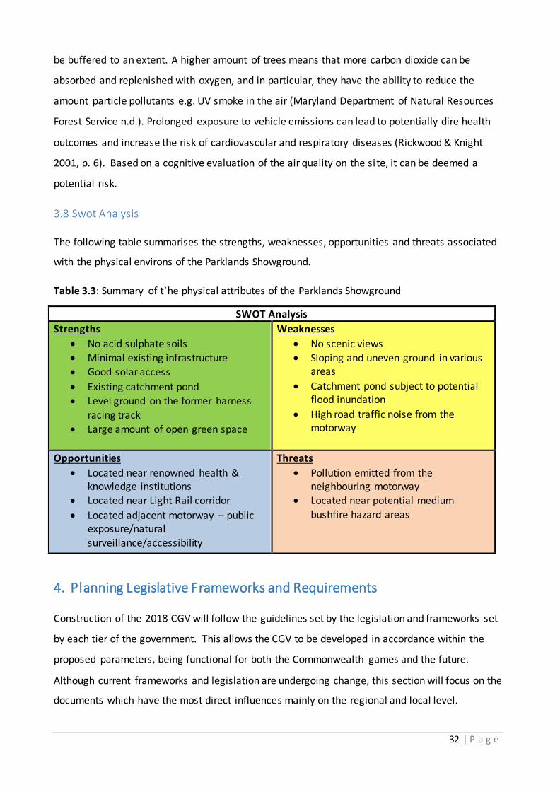
3.8 Swot Analysis
The following table summarises the strengths, weaknesses, opportunities and threats associated
with the physical environs of the Parklands Showground.
Table 3.3: Summary of t`he physical attributes of the Parklands Showground
4. Planning Legislative Frameworks and Requirements
Construction of the 2018 CGV will follow the guidelines set by the legislation and frameworks set
by each tier of the government. This allows the CGV to be developed in accordance within the
proposed parameters, being functional for both the Commonwealth games and the future.
Although current frameworks and legislation are undergoing change, this section will focus on the
documents which have the most direct influences mainly on the regional and local level.
SWOT Analysis
Strengths
No acid sulphate soils
Minimal existing infrastructure Good solar access
Existing catchment pond Level ground on the former harness
racing track
Large amount of open green space
Weaknesses
No scenic views
Sloping and uneven ground in various areas
Catchment pond subject to potential flood inundation
High road traffic noise from the motorway
Opportunities
Located near renowned health & knowledge institutions
Located near Light Rail corridor
Located adjacent motorway – public exposure/natural
surveillance/accessibility
Threats
Pollution emitted from the neighbouring motorway
Located near potential medium
bushfire hazard areas

33 | P a g e
The development of the CGV will be determined by legislative requirements and restrictions that
need to be observed, in order for the proposed development to be approved. This will address the
way in which the developer needs to establish key objectives in accordance with local, state and
national legislation.
The main legislation governing the development for the CGV is the Economic Development Act
(EDA) 2012. Under the EDA, the Parklands site was declared a priorty development area (PDA) on
1 February 2013 (Queensland Government 2013c, p. 1). Under this PDA the site had an Interim
Land Use Plan (ILUP) prepared for it, which applies only to land within the declared Parklands PDA
boundary (Queensland Government 2013c, p. 1).
The land use planning and development of the site will be managed by Economic Development
Queensland (EDQ). The development of the PDA will aide in the delivery of the 2018 CGV, whilst
also promoting long term development opportunities for the site.
Table 4.1: Legislation and frameworks applicable to the Commonwealth Games Village site
Legislation and Frameworks.
Purpose and intent Relevance to the site
Economic Development Queensland (EDA)
EDA plays a key role in streamlining and fast-tracking developments.
Land use planning and development of the s ite is managed by Economic Development Queensland.
Provides the main planning document for the Parklands PDA.
Sustainable Planning Act 2009
(SPA 2009) Guideline for a ll subsequent regional and
loca l planning frameworks within Queensland.
Sets minimum requirements which must be fol lowed by a local government.
Aims to achieve ecological sustainability.
Used to settle any planning disputes that may confl ict with regional and local plans.
Gold Coast Planning Scheme (GCPS)
Released by the Gold Coast Ci ty Council.
Manages the future growth and
development of the Gold Coast ci ty.
The scheme regulates assessable
development.
Location and proximity to certain sensitive areas
(waterways , ecosystems and vegetation).
Natura l hazards and public safety (flooding, fire,
health).
Infrastructure needs (provision of amenities and
connectivity).
Particular ones include, building height, densities, and provisions for environmental effects.
Southport Local Area Plan (GCCC)
Provides detailed planning and development of the area.
Sets guidelines for developments within
Southport. .
Maintains Southport as an outstanding environment in which to live and work.
Focuses on keeping Southport a vibrant, safe,
pedestrian-friendly place which has a strong community.

34 | P a g e
4.1 Material Change of Use and Reconfiguration of the Lot
As the construction of the CGV is governed as a PDA under the Economic Development Act 2012
(EDA), there is no requirement to produce a material change of use or reconfiguration of the lot.
However, NEXUS planning has included a hypothetical material change of use and reconfiguration
of the lot to allow for any unseen changes in government, as seen below.
4.1.1 Material Change of Use
Post-Commonwealth Games, NEXUS Planning will transform the CGV into a thriving residential
community, as all properties will be available for residency. Therefore, the 2018 CGV may undergo
a material change of use. As defined by the Sustainable Planning Act 2009, a material change of
use “is where there is a change in the purposes for which or in the circumstances in which a
building is used, so that after the change the building” (Queensland Government 2013d).
The CGV will need to adhere to these changes as it is re-establishing a new use of the land, as well
as significant changes to the structures constructed for the CGV in 2018. These structures will be
retrofitted after the completion of the Commonwealth Games.
4.1.2 Reconfiguration of the Lot
Reconfiguration of the lot will require NEXUS Planning to submit an IDAS 7 form to the GCCC, in
accordance with the Sustainable Planning Act 2009 (Gold Coast City Council 2013a, p. 7 ). This
application form will contain all the supporting documents, plans and drawing, and special reports
required to successfully apply for a development permit.
In accordance with GCCC IDAS 7 form, NEXUS Planning will provide:
Planning assessment report containing a covering letter, report and conclusion
All the governance codes relevant to the site and proposed development to be completed
using council’s code table template
Photographs to support the application
Plans and drawings of the site; as well as
Speciality reports of the site including environmental health reports, acoustic reports,
waste management, transport, traffic , open space and landscaping

35 | P a g e
4.2 Approval Times and Costs
As this development is being produced under the PDA, all subsequent applications or
modifications and costs issued for the development approval will continue to be assessed by EDQ.
This will reduce all approval times associated with the development of the site (Queensland
Government 2013e). However, if there is a change in government and the development is no
longer listed as a PDA, all approval times and costs should be refered to the Gold Coast City
Council, as there fees and charges now become applicable. Development application fees that will
be required for our proposal, include considerations for: environment, infrastructure, and
engineering services in addition to other development specific fees (Gold Coast City Council
2013b).
Infrastructure charges are developer contributions that must be paid to council . These
accommodate for the impacts on infratsturcute in the surrounding area of the proposed
development. These charges are calculated by determining assessable demands on the
infrastructure, whereby an estimate of infrastructure charges is dependent on the number of
dwellings in the proposal (Gold Coast City Council 2013b).
4.3 Compliance
Compliance of the site will directly be managed under the EDQ, and will work in conjuction with
local governments to undertake planning within the PDA. Codes and policies from the Gold Coast
City Council have been included below, to be used where appropriate if the site under goes a
change and does not remain a priority development area.
4.3.1 Codes and Policies
The codes and policies for the development, as outlined by the GCCC, establish development
provisions. They account for the site specific development codes, constraint codes , as well as the
policies for: land development, infrastructure facilities, and energy conservation as listed within
the Appendix 3.

36 | P a g e
4.4 Planning Process Chart
Figure 4.2: Planning process chart
5. Project Risks and Impacts
5.1 Traffic
The development of a Commonwealth Games Village and the subsequent uses of that
development after the 2018 Games have finished, will have a noticeable impact on traffic flow in
the area. With the Village catering for 4,500 athletes and then 4,500 residents afterwards, the risk
for road infrastructure to be unable to cope with such a sudden influx of vehicles is very high.
The Department of Transport and Main Roads (DTMR) are responsible for road infrastructure
improvements in Queensland, but it is likely that Ecoji and the GCCC will have to fund part of the
infrastructure improvements to ensure the marketability and reputation of the site is maintained.
DTMR Weekly Traffic volume reports, from 2010 (see Appendix 4), show that the Smith Street
Motorway section between Kumbari Avenue and Parklands Drive has two peak traffic times. The
first is between 8am and 9am in the Easterly direction, where around 4,000 cars pass through in
that hour. The second is between 3pm and 6pm in the Westerly direction, where up to 4,500 cars
per hour use Smith Street Motorway in this timeframe. An addition of 4,500 residents on our site
(located between Kumbari Avenue and Parklands Drive) could overload the system and cause a
severe traffic problem, especially when there is the potential (unlikely, but possible) to have 4,500
cars added to the road-user totals listed above due to our development.
NEXUS Planning Process Chart

37 | P a g e
The intersection between Smith Street Motorway and Parklands Drive will also be affected by our
development. Data supplied by AusTraffic (see Appendix 5) indicates a number of things: 3,529
cars transferred from Parklands Drive to Smith Street Motorway via this intersection (1,373 to the
West and 2,156 to the East) and 2,822 cars transferred from Smith Street Motorway to Parklands
drive via this intersection (2,308 from the East and 1,514 from the West). It can be inferred from
the data that there are at least 6,351 cars using Parklands Drive, between Smith Street Motorway
and the next intersection at Engineering Drive, per day. The current intersection here should be
adequate, but will need to be adjusted to account for more traffic from the Eastern side.
Note: Pedestrian use of the Smith Street-Parklands Drive intersection and Parklands Drive-
Engineering Drive intersection will have to be accounted for and both intersection systems
adjusted to accommodate an increase in foot traffic.
The way our site interacts with the surrounding roads is a crucial part of the development. We can
choose from a number of options to counteract/reduce the impact of our development on
surrounding roads (particularly Smith Street Motorway) such as:
On/Off ramps (above or below ground)
Intersection
Roundabout
As there is already an intersection at the corner of Smith Street Motorway and Parklands Drive, a
second set of traffic lights less than 500m away could worsen the situation. A roundabout would
also not likely be very effective, as the opportunity for residents leaving the site via a roundabout
is limited due to the high flow of traffic during peak hours. This would likely cause traffic jams
within our own development.
The option to construct on/off ramps connecting the development to both directions of Smith
Street Motorway would prove to be the best option in this case. It will not fully alleviate traffic
congestion, and will almost certainly contribute to it, so NEXUS Planning and DTMR will meet to
discuss what can be done to further mitigate the impact on traffic flow in the area in regards to
how the site access roads interact with surrounding infrastructure.

38 | P a g e
5.2 Parking
The light rail system soon to be servicing Southport (and eventually more parts of the Gold Coast),
will play an integral role in the success of the Village development as a TOD. If the light rail system
is unsuccessful, and does not perform as well as expected, the village development will also suffer.
Our design for the development will also affect the light rail system. By providing high levels of
parking for all residents, we would be encouraging (Feeney 1989) (or at least facilitating) the use
of cars and reducing the likelihood of residents using the light rail system. However, we
understand the need for cars as the Gold Coast public transport is not a high quality transport
system and cars have become a necessity. Therefore, by providing limited parking, we can
encourage residents to make the most of the light rail system and forms of transportation other
than a car.
5.3 Walkability
The village development is designed so that it will include some small and local businesses to cater
for the basic needs of the residents and employees in the area. Similarly, access to other nearby
external facilities is also important. Walkability around, and within, the development is therefore
considered an important factor as it will reinforce the TOD aspect of the development and will be
reflected in the overall marketability. Additionally, if walkability cannot be fully integrated or
achieved in the development, there will be a higher demand for motorised transport (either public
or private). By ensuring we incorporate the practice of walkability into the development, we can
minimise reliance on motorised transport. There may also be the opportunity to provide bicycles
for residents similar to the system implemented in Brisbane, where this would provide another
option for residents and yet again reduce demand for personal motorised transport. The smaller
demand for motorised transport can further reduce the necessary parking we supply and will also
increase marketability for potential buyers/investors post games as a “central location”.
5.4 Noise
The traffic is also likely to effect the marketability of the development to buyers and investors
post-Commonwealth Games. The noise and environmental impacts will be the two main factors
buyers are likely to find least attractive. To combat this, our design for the site will integrate a row
of commercial offices adjacent to Smith Street Motorway to block/reduce the noise that reaches
any residential areas that will be placed further away from the major road. Measurements

39 | P a g e
conducted by Michael Minor & Associates Consulting Firm have shown that a single story dwelling
can reduce noise by as much as 10dBA (decibels) or more, dependent on location of the sound and
position of the receiver (Michael Minor & Associates n.d.).
Passenger vehicles have been highlighted as the main form of vehicle on the Smith Street
Motorway after completing a cognitive study. They typically produce around 70dBA (Michael
Minor & Associates n.d.) from a distance of 15 metres. A reduction of at least 10dBA (through
smart building placement) would equal a similar sound to a large store air-conditioning unit
(Michael Minor & Associates n.d.). As the actual location for residential apartments will be much
further than 15 metres, the relative noise level will be closer to 45dBA. This can be further
reduced by using materials better equipped to block noise e.g. double-glazed windows and
thickened walls.
Other residential areas in our development will be able to utilise some vegetation to mask the
noise, not necessarily reduce it. Washington State Department of Transportation (2013) concluded
that roughly 50m of dense vegetation is enough to audibly reduce the noise from traffic. Though
it may not measurably reduce the noise, psychological relief from a dense vegetation may be
obtained, however, due to spatial constraints the implementation of such vegetation is not a
practical option for our development. Roadside vegetation, along with careful placement of
building and insulated or sealed units, will be enough to counteract most negative impacts of
traffic noise in the development.
The light rail system will also be a factor for noise in the area. The construction stage will be
completed before the 2018 Commonwealth Games, therefore construction noise will not be a
factor. However, operational noise will have to be considered.
The NSW Government (2010) released a preliminary environmental assessment for the extension
of the Sydney Light Rail in July 2010. They identified that the most relevant impacts in regards to
noise included airborne and trackform noise. The report also identifies the key sources of the
noise as vehicle speed, wheel condition, rail condition, track features, rolling stock design and
distance from receiver. Assuming that track and vehicles are well maintained by GCCC, most of
these issues should be minimal. The implementation of a noise barrier along the track in areas that
are at risk to residential disturbance would also help counteract the impact it has on
residents/businesses and will be further assisted by the solutions mentioned above.

40 | P a g e
5.5 Environment
Due to the small size of the protected essential habitat on the site, there is a potential risk for
fragmentation and edging effects to occur. During the site inspection, it was noted that the area
located next to the essential habitat was thriving with biodiversity. Many species of birds, such as
ducks, magpies and native cockatoos were spotted foraging within close proximity to the habitat.
Therefore, if it is allowed to persist, the consequences of habitat fragmentation can lead to an
‘islanding’ effect which can eventually displace some species which inhabit the ecosystem
(Andrews 1990, p.130).
In order to minimise any ecological disruptions to both the wildlife and existing remnant
vegetation of the essential habitat, it is recommended that a small sus tainable botanical garden be
featured beside it. It will not only act as a natural buffer zone for wildlife species, but preserve the
integrity of the essential habitat and reduce edging effects, as well as balance the damp conditions
of the microclimate nearby by implementing native hydrophilic plant species. Some native
hydrophilic plants which could be planted include (ERA Nurseries 2013):
Acacia dealbata (Silver wattle)
Acacia howittii (Sticky wattle)
Melaleuca ericifolia (Swamp paperbark)
Melaleuca lanceolata (Dryland tea tree)
The incorporation of these native Australian shrubs will allow the garden to display Australia’s
unique and diverse flora for the international athletes. For post Commonwealth Games residents,
it will become a scenic and recreational feature with high accessibility as it will be conveniently
located within the residential precinct.
It is also crucial that our building design does not negatively impact the essential habitat on site, or
any other habitat for that matter. So we are creating our development with urban sensitive design
in mind. This includes building design and walkability in the development, so that the critical
habitat is far less likely to be damaged or deteriorate. Along with the addition of a botanical
garden to act as a buffer for the essential habitat, the essential habitat should flourish.
The essential habitat is listed as having the required resources for a number of endangered
species, and as such, is an important part of preserving biodiversity. The Koala, Green Thighed
Frog and Wallum Froglet are listed as vulnerable or near threatened by the Queensland

41 | P a g e
Government (see Site Analysis) and the essential habitat has the resources they require to survive,
as such, it must be preserved/enhanced.
The site has a very low risk of bushfire damage, the areas surrounding however, would be of more
concern. Appropriate fire safety plans and building standards designed for fire safety must be
implemented in case of any fire in the area that could threaten the development and its residents.
5.6 Drainage
From the site analysis, we have concluded that the current drainage facilities on site are more
than adequate. Our development however, will have a definite impact on these systems as the site
would be altered to make development easier. Flattening out the rises and depressions on the site
will also result in moving the current drainage facilities. Consequently, the only remaining drainage
feature from the original site will be the catchment pond.
To account for an increased need in drainage, we will develop the site so that water runoff is
mostly directed towards the catchment pond. There will also be stormwater drainage linked to the
Gold Coast City Council’s current stormwater drainage infrastructure to help offset the runoff even
further. Rooftop gardens and semi-permeable pathways can further counteract the potential for
flooding or inundation.
Another key aspect of a good drainage system is the ability for the water to reach drainage points
unobstructed. The main obstruction in this case will be the residential, commercial and mixed use
buildings we construct. The immediate space around the catchment pond has been designated as
open space for the purpose of a park, and to increase the capacity for drainage to the catchment
pond. Additionally, buildings opposite the area will have sufficient drainage facilities to more than
adequately dispel any water from the area to minimise maintenance costs and risk to building
structure.
5.7 Community
The development, post-Commonwealth Games, will be available for anyone to live in. Therefore,
the pricing and functionality of the site will be imperative in maintaining a multicultural and
multiclass society. If prices are too high, then mostly upper class people will be able to afford to
live in the development. The main demographic in Southport is an English speaking, Australian

42 | P a g e
born person (Australian Bureau of Statistics 2011), therefore if the development cannot cater for
multiple cultures, then it will likely only represent the current ethnic trend, not encourage the
trend, as we would desire. If our development is eventually bought by people who fit this
description, then our development may still be seen as successful, however, it is not the most
desirable outcome, and not one we aim for, as we would like our development to encourage
multicultural growth in the area (currently the English speaking, Australian born demographic sits
at around 55 per cent (Australian Bureau of Statistics 2011)). An inability to cater for multiple
cultures/classes would likely increase the economic and/or ethnic gap in society, but would not
cause any harm to anyone, put the site, or development, at risk.
By including multicultural aspects into the development e.g. range of restaurants and shops, we
are able to diversify the number of cultures present on the site. In 2006, 1 in 5 Australians were
born overseas (Australian Bureau of Statistics 2006), and now almost 45 per cent of the people
who live in Southport were born overseas (Australian Bureau of Statistics 2011). We aim to
encourage this trend by further diversifying the area and believe our development will be capable
of doing so. Nearby religious facilities (such as churches, mosques etc.) would further improve the
site’s potential to become a central location.
5.8 Government and Finance
A change in State Government from Liberal to Labor (or any other party) could have the potential
to alter the level of funding available for the development. However, due to the international
importance of the development, State Government would be ill advised to drop any amount of
funding as it could have a detrimental effect on the outcome of the development.
Also associated heavily with the outcome of the development, is the sources of funding other than
government funding. Ecoji and associated investors must maintain (or improve) relationships to
ensure funding is secured, so that the development can meet and exceed expectations on an
international level. This will ensure that the development is the new benchmark standard for
future villages.
A major risk in the development is the possibility of falling short of sales targets. Our development
is designed to be sustainable, yet affordable. The uniqueness and potential of the site will be
enough to attract buyers, but we must also provide a good marketing strategy to ensure sales
targets are met to return the desired profit to all parties. The marketing strategy will highlight the
43 | P a g e
benefits of living in the development and will be critically analysed to ensure that it will help the
development reach its potential.
DISCLAIMER FOR IMPACTS:
Electrical, sewerage, water supply etc are not considered issues important enough for this report
While we have endeavoured to fully research and predict the risks and impacts associated with
this development, we cannot be 100 per cent certain of the end result.
6. Statement of Proposal
Our proposal will involve the development of 10 new buildings on the site including a mixture of
commercial, residential and mixed-use buildings. The buildings and infrastructure on site (roads,
pathways etc) currently takes up approximately 29 per cent (82088m2) of the 29 hectares
available. We intend to create 6 residential apartments, 2 commercial buildings, 2 mixed-use
buildings along with minimal undercover carparking (underneath one of the apartment blocks)
and tennis and swimming facilities. The buildings we construct will vary in height, ranging from 3
to 5 stories.

44 | P a g e
SWOT Analysis (Post Development)
Strengths
Development is located near
Southport central-business-district
Desired location due to being located
within the Southport health and
knowledge precinct
Development will be highly publicized
due to international attention from
the Commonwealth Game
Weaknesses
Opportunities
Create the new benchmark for TOD-
based communities
Encourage community interaction
Enhance the image of the local area
Providing affordable housing
Influence future development
Influence future legislation changes
Increase Gold Coasts image of public
transportation
Threats
Constant traffic due to infrastructure not
being able to cope with the traffic
Reliance on personal motorized
transportation due to a lack of public
transportation
Increase in crime
Lack of security for residents
Discourage the use of public
transportation
Existing public transportation may not
support the additional development
population
Development does not met budget
requirement
May not met development requires set
by Ecoji
Development is aesthetically unpleasing
Not used by residents and therefore is
neglected
Development may become isolation
from the rest of the community
Development may not be sustainable
Development has a negative impact on
critical vegetation nearby

45 | P a g e
6.1 Governance
It is still undetermined who will receive control of the land after the completion of the 2018 Gold
Coast Commonwealth Games, however, control may be turned over to the Gold Coast City
Council. Additionally, it is noted that Ecoji will be receiving profits from the sales of the units on
the site.
The Minister for Economic Development Queensland (MEDQ) has assumed planning powers,
which include assessing development applications for the purposes of the CGV project. The MEDQ
will be the landowner throughout the development and the 2018 Commonwelath Games, whilst
EDQ is the responsible delivery agency. Project decisions by EDQ will be guided by the
Commonwealth Games Infrastructure Authority, who will report through its chairperson to the
EDQ Board. Figure 4.1 below represents the roles of each organisation with the EDQ.
Figure 4.1: Roles and relationships of organisations with EDQ
Source: (Queensland Government 2013a)

46 | P a g e
6.2 Tenure
After the completion of the Commonwealth Games in 2018, NEXUS Planning suggests that the lot
be transformed into residential and commercial strata title development, with the
implementation of the Community Titles Act 1996 and Community Management Act 1997. This
will ensure that maintenance of the development will be overseen by a body corperate. This
enables the subdivision of land and buildings into tenancys and common property (Queensland
Government 2013f pp. 45-47). The tenancy will refer to the units or any part of the unit which is
owned by a landowner. This will include any space owned privately and not designated as ‘not fit
for human occupancy’.
Common property will be designated as everything on the site that is not contained within a strata
lot. This property will be controlled by the body corperate which comprises all of the owners as a
collective body. The body corperate will maintain these features of this site through mandatory
contributions of the lot owners, established as a levy payment system.
It is recommended that the critical habitat located on the site either be turned over for maintence
to the GCCC post-Games.
Obligations of those who live or rent there lots are as follows:
Table 4.2: Obligations of land owners
Principle Obligations of Land Owners Principle Obligations of Land Owners Who
Are Leasing. To pay rates, taxes and strata levies. To ensure compliance with the scheme's by-laws
is a condition of the tenancy agreement.
To notify the Owners Corporation of any change in ownership or occupancy.
To supply the tenant with a copy of the scheme's by-laws.
To comply with the scheme's by-laws. To notify the Owners Corporation of any change in ownership or occupancy.
To behave in a manner which won't offend other residents or interfere with their peaceful enjoyment of the scheme.
To notify the Owners Corporation of:
the name of the tenant
the date the tenancy commenced the name of any property agent
involved.

47 | P a g e
7. Concept Plan

48 | P a g e
8. Recommendations
8.1 Site Recommendations
NEXUS Planning have compiled the following set of recommendations for the development of the
2018 Commonwealth Games Village.
8.1.1 Sustainability:
After a carful review of literature and SWOT analysis of the Parklands Showground’s si te, NEXUS
Planning has concluded that for a legacy and sustainable development the integration of
economic, environmental and social aspects associated with the site (Hediger 2000; Kaygusuz
2009; Coffman & Umemoto 2010; Govindan et al. 2013). The following environmental
sustainability features are essential for an optimum sustainable development: Bio-swales, Rooftop
gardens, Botanical gardens, Solar panels, Solar Street lights, Permeable road, Recycled concrete.
The development will Utilize meduim to high density housing as suggested method by Choguill
(2008, p.44) as it is economicically sustainabe. For a development to be considered econimicaly
sustainable NEXUS recommends the inclusion of low income housing . This offers direct economic
benefits to the owners due to it’s energy and money saving techniques (Levin 2013). NEXUS
Planners akcnowledge that a strong sense of community, safety, and community engagement are
key to produce social sustainability developments Dempsey et al. (2011, p. 297). NEXUS
recommends that each feature is implemented in order to insure that CGV will become a legacy
development.
8.1.2 Transport Oriented Design:
NEXUS aims to create a development that is inline with Ecoji’s goal for a Transit Oriented
Development. This can be achieved by ensuring that: there are mixed use facilities, it is pedestrian
friendly and ensures public transport connectivity. If successful, this leads to a reduction in the
reliance on personal transport. NEXUS recommends that walkability in the area is improved to
account for pedestrian use, mixed use facilities cover a wide range of needs to reduce the need for
travelling outside of the development and that public transport is sufficient to be an effective
mode of transport for residents in the village. The latter recommendation is particularly critical as
the current bus system is regarded as highly unreliable and ineffective by the community. This
reputation needs to be drastically improved for the development to be successful.

49 | P a g e
8.1.3 CPTED:
Queensland Government’s 2007 document titled “Crime Prevention Through Environmental
Design” concludes that neighbourhood safety is a critical component in the success of a
development such as ours. Grohe 2011 analyses the elements that lead to a perception of safety.
She determines that: more landscaping, community investment (signs/decorations), symbolic
barriers (beware of dog signs), high visibility, surveillance and high levels of upkeep lead to a
positive perception of safety by residents. NEXUS recommend that the above criteria are fully
adhered to so that the development can become even more of a community in its own and
succeed as a benchmark development, not only for the Commonwealth Games, but also as a TOD,
Ecocity and apartment living.
8.1.4 Traffic:
The impact on traffic due to a sudden and intense increase in residents in the area will likely lead
to local infrastructure being unable to cope and traffic jams become more frequent and for longer
periods of time. NEXUS recommend the utilisation of a series of ramps to guide vehicles to and
from the site connecting to Smith Street Motorway, as this will be the most effective way of
dealing with the traffic. Further mitigation with DTMR is required to inves tigate future upgrades to
the Smith Street Motorway.
8.1.5 Noise:
To counteract the impact of living next to a busy stretch of road and the noise associated with it,
NEXUS recommend that commercial buildings (5 stories high) are placed along the Smith Street
Motorway to block some of the noise coming from the car traffic. It is also recommended that
residential apartments are constructed with noise insulation in mind to further reduce external
noise that could negatively impact the sale of the apartment.
8.1.6 Environment:
The essential habitat has been identified in the above report as a critical component for preserving
biodiversity. NEXUS recommend the implementation of a botanical garden to act as a buffer for
the habitat and to reduce impacts of habitat fragmentation and fringe effects. This will make sure
that our development is seen as a new benchmark in a number of aspects, including TOD, CGV and
ecological preservation.

50 | P a g e
8.1.7 Urban Ecology:
After reviewing literature regarding to Urban Ecology-based principles, NEXUS Planning
recommends that the 2018 CGV seeks to design a development which works with the
environmental ecosystems of the site, in order to avoid environmental damage. The
implementation of ecocity based principles of minimizing overall ecological impacts, aesthetic and
functional balance between landscape and built-form is found, and buildings are safe and efficient
in the use of resources, as identified by Urban Ecology Australia Inc (2013) are vital. Principles
identified by Ecopolis Architects (n.d.) should also be integrated within the design: restore
degraded land, fit the bioregion, balance development, create compact cities, optimize energy
performance, contribute to the economy, provide health and safety, encourage community,
promote social justice and equity, and enrich history and culture.
8.1.8 Community:
To ensure our development is multicultural and multiclass, NEXUS recommend the development
utilise different size apartments to target a larger demographic that is more likely to include a
greater ethnic diversity and class base. It is also recommended that the business spaces available
are promoted to increase the types of businesses on site e.g. culture specific shops (Chinese
restaurant) and this will further reinforce the development as multicultural and multiclass.
8.1.9 Walkabilty:
The ability for the site to connect with surrounding facilities is particularly important, not only via
motorized transport, but also by walking and cycling. This is why NEXUS recommends that
surround infrastructure related to walking and cycling is improved to increase the likelihood of
walkability and cycling becoming a major component to the success of the development.
8.1.10 Drainage:
After conducting the site analysis, the current drainage infrastructure was deemed adequate for
its current use. However, the addition of roads, pathways and buildings on the site will reduce the
effectiveness of the drainage. NEXUS recommend: the installation of semi-permeable roads and
pathways, to assist in reducing groundwater runoff, the placement of buildings to allow for any
runoff to be directed towards the catchment pond, installation of rooftop gardens to minimise
rainwater runoff from the building itself and the installation of appropriate stormwater drains
connecting to the existing GCCC stormwater infrastructure.

51 | P a g e
8.1.11 Parking:
Society’s reliance on personal motorised transport means that if we are to meet sales targets to
achieve a profit for all parties involved, then we must include parking provisions for residents. The
success of the development as a TOD relies on the residents use of public transport and
walkability. If they have access to private transport as they do currently, there will be no
motivation for change. NEXUS recommend a restricted carpark so only some residents have access
to car parking. The carparks will be associated with a particular apartment block only available to
those residents. This will ensure that the majority of residents and employees on the site fully
utilise the light rail system, bus routes, cycling paths and walking tracks to make their way around.
There will be a maximum limit on parking within the CGV rather then a minimum. It is important
to note that the implementation of the light rail is expected to commence in late 2014. This
infrastructure will provide residents with viable transport opportunities to get to both work and
leisure activities (refer to Figure 1.3) and will increase the likelihood for the development’s success
as a TOD.
8.1.12 Government and Finance:
NEXUS has analysed the possibility of a change in State Government and the effect it would have
upon funding for the development. Due to the importance of the development, any State
Government body who are currently providing funds towards the development would be ill
advised to reduce/remove their funding. This opportunity to create a benchmark development for
the 2018 Commonwealth Games Village is too good to give up, and should be finished to that
standard at any cost. NEXUS recommends that Ecoji maintain and/or improve any relationships
they have with other parties providing funds for the development to ensure that it can reach its
full potential.
8.2 Liveability Post Commonwealth Games
In order to create a successful legacy development for the post Commonwealth Games, it is
recommended that liveability concepts are integrated into the built design. This can be achieved
through the implementation of:
vibrant community art in public areas
mixed land use to encourage walkable communities
decorative gardens/streetscape to create a scenic environment

52 | P a g e
a pedestrian friendly environment
By incorporating such unique elements to the development, they can simultaneously compliment
the urban form, increase place making and overall contribute to a socially and environmentally
friendly atmosphere.
8.3 Facilities During and Post Commonwealth Games
Due to the abundance of local sporting and recreational facilities near the Parklands Showground,
it is recommended that only the most marketable and commonly used sporting facilities are
developed on the site. It is advised that two standard tennis courts and an Olympic size swimming
pool be implemented as they are the generic sporting facilities for almost all Athletes Villages in
the past. In the long term, these facilities will also prove to be highly marketable features for the
post Commonwealth Games Village. The competitive lanes from the swimming pool can be
converted into an open aquatic area for recreational swimming, which is a viable concept. If there
is an abundance of sporting facilities implemented on the site, these facilities are likely to be
under-used by the residents post Commonwealth Games. As well as this, additional costs will arise
due to the body corporate maintenance fees of these facilities as well as an overall increase in
project funding costs required to develop them. For this reason, the local Gold Coast City Council’s
Athletic Track can be used to facilitate the athletics competitors as an alternative to developing an
Olympic size track on the site.
8.4 Marketability
The proposed development promotes sustainability, safety and liveability. NEXUS Planning will aim
to increase marketability of the development through a TOD development on the Gold Coast.
Understanding the current size of families will provide NEXUS will the ability to market the
development for individual family needs of the surrounding community, widening the market for
housing sales.
This development will become a major transportation hub containing medium to high density
residential housing and commercial property, therefore the use of a strong focus on transit
oriented design will subsequently result in a reduction of private vehicle transportation
dependency and lowering the necessary parking supply (Profile id. 2013b).

53 | P a g e
The marketing strategies used to sell the development will be characterised by a clear
understanding of what the current market desires. The marketing will divide into different forms
of advertising, paper, print and multimedia. However, during the Commonwealth Games free
advertising will be gained from promotion of the CGV. This will promote the beauty and splendour
of the village through a strong television presence. NEXUS Planning will also aim to promote land
sales through billboards scattered in heavy traffic areas in both Southport and Surfers Paradise.
According to Taylor (1997) billboards are cheap and effective advertisements for developments
(Taylor 1997, p. 179). The creation of an online virtual tour will also be implemented to promote
sales and interest and having it online will improve ease of access from the general population as
well as international markets. This concept will also be implemented with a fully furnished
apartment to be shown to potential clients.
Based upon prior analysis, it is recommended that 15 per cent of the housing from the CGV be
directed towards second home buyers, and 10 per cent to first home buyers. Second homebuyers
provide less risk, and hold higher capital gains; however, second homebuyers may be harder to
provide for due to their capital allowing for wider market for them. To minimise this ris k, the 25
per cent being sold off immediately post games are higher-end apartments designed in order to
accommodate for second homebuyers needs.
Based on Southport’s current market conditions represented above, it is recommended that the
remaining 60 per cent will be sold to property investors for renting. This housing will be designed
to suit coupled families and share accommodation, utilizing the Griffith Universities expected
increase of students, located across the road from the development.
9. Project Development Funding
9.1 Estimated Price:
The purchase price of the Parklands Showground is estimated to be $80 million. This includes the
existing infrastructure on the site plus the land value. Ecoji have advised that for Stage 1 of the
preliminary site development, $60 million dollars will be made available. The City of Gold Coast
will provide free connections on water and waste water infrastructure valued at $15 million. After
a detailed financial analysis of the costs related to the preliminary site development, it is
estimated that an additional cost of approximately $398 million will be required. This additional
cost will be used to incorporate the sustainable and liveable elements outlined in the

54 | P a g e
recommendations. The estimated cost projection for the development of the site is
$458,314,565.00 in total - see Appendix 6 for an evaluation of the cost projections.
9.2 Profit:
It is estimated that the CGV will make a total profit of $274 million.
Table 8.2: Estimated profit for the Commonwealth Games Village
9.3 Financial Arangments:
The following table summarises the various loan options from banks with their respective interest
rates and application fees.
Table 8.2: Loan options
Bank Loan Type Interest Rate Application Fee
Commonwealth Bank
Overdraft 7.30 % per annum None
Global Capital
Commercial
Development Finance 5.4% per annum None
Westpac
Corporate Credit Loan ($50 million to $1
billion)
2.00 % per annum None
NAB Premises Loan 7% per annum None
Total Development Costs ($) Total Sale Price ($) Profit ($)
Residential
1 bedroom apartment 170,000,000.00 292,600,000 122,600,000
2 bedroom apartment 139,000,000.00 237,800,000 98,800,000
3 bedroom apartment 45,000,000.00 68,750,000 23,750,000
Commercial 42,750,000 57,000,000 14,250,000
Mixed Use 15,200,000.00 30,400,000 15, 200,000
TOTAL 411,950,000.00 686,550,000 274,000,000

55 | P a g e
10. Conclusion
The scoping and feasibility study for the 2018 Commonwealth Games Athletes Village and post
CGV has focused on incorporating elements of sustainability, urban ecology, liveability and TOD
best practices. Through a regional analysis and assessment of the current and past market trends
within Southport, the CGV is within an area of high local growth - in terms of population and
infrastructure. The Health and Knowledge Precinct coupled with the RTC provide the development
with promising opportunities to become a central hub. The literature based on the three main
principles emphasised in this report, indicate that the TOD in combination with sustainable
aspects delivers the most viable development outcomes. The site is relatively safe to build upon,
and no major physical challenges were identified. Major challenges for policy involve conforming
to the EDQ and acknowledging the SPA 2009 and the GCCC policies in case there is a change in
government. The major risks of the site are related to the increased traffic, noise and
environmental damage but can be mitigated. To increase post commonwealth Games
marketability, it is recommended that liveability elements are incorporated as they compliment
the urban form. The incorporation of sustainable, liveable and TOD elements are expensive, but in
the long term, will negate these initial costs. NEXUS Planning is committed to providing Ecoji with
an innovative and ecologically sustainable development that will enhance both the image and
profitability of the company and provide a lasting legacy development on the Gold Coast. The
Design Proposal in the next stage will provide a detailed master plan and overview of the final
design of the 2018 Commonwealth Games Athletes Village.

56 | P a g e
11. Invoice
NEXUS PLANNING September 2, 2013
INVOICE #001
Bill To:
Customer Dr. C. Bosman
Ecoji
Customer ID# 00496
Address Griffith University, G31_3.04 Southport, Queensland, 4215
Phone (07) 5552 7721
Payment Due September 23, 2013
Salesperson Ared Woskanian
Payment Terms Cheque
Qty. Item# Description Unit Price Discount Line Total
120 1 Ared Woskanian (Work Done) $200/hr 0% $24,000.00
120 2 Adam Jarret (Work Done) $200/hr 10% $21,600.00
100 3 Jesse Kahler (Work Done) $175/hr 10% $15,750.00
70 4 Jonathon Kelly (Work Done) $220/hr 10% $13,860.00
140 5 Lachlan Fraser (Work Done) $150/hr 0% $21,000.00
0.5 6 Presentations $400/hr 50% $100.00
5 7 Consultations $750/hr 0% $3,750.00
Tota l Discount 0%
Subtotal $100,060.00
GST $10,006.00
Total $110,066.00
Thank you for your business
4/138 Signato Drive, Oxenford, Queensland, 4210
Phone: (07) 5562 0084 | Fax:(07) 5562 0088 | [email protected]

57 | P a g e
12. References
Andrews, A. 1990, ‘Fragmentation of habitats by roads and utility corridors: A review’, Australian Zoologist, vol. 26, no. 3, pp. 130-141.
Antrop, M. 2004, 'Landscape change and the urbanization process in Europe', Landscape and
Urban Planning, vol. 67 no. 1-4, pp. 9-26.
Australian Bureau of Statistics 2006, 2006 census community profile series: Southport (online),
Available:
<http://www.censusdata.abs.gov.au/ABSNavigation/prenav/ViewData?&action=404&docu
mentproductno=SED30075&documenttype=Details&tabname=Details&areacode=SED3007
5&issue=2006&producttype=Community%20Profiles&&producttype=Community
Profiles&textversion=false&navmapdisplayed=true&breadcrumb=D&&collection=census&
period=2006&producttype=Community Profiles&#Basic Community Profile> (23 August
2013).
Australian Bureau of Statistics 2011, 2011 census community profiles: Southport (online),
Available:
<http://www.censusdata.abs.gov.au/census_services/getproduct/census/2011/community
profile/SED30075?opendocument&navpos=230> (23 August 2013).
Australian Government 2009, EPBC Act List of threatened fauna (online),
Available: <http://www.environment.gov.au/cgi-
bin/sprat/public/publicthreatenedlist.pl?wanted=fauna>
(28 August 2013).
Bailey, K., Grossardt, T. & Pride-Wells, M. 2007, 'Community design of a light rail transit-oriented
development using casewise visual evaluation (CAVE)', Socio-Economic Planning Sciences,
vol. 41, no. 3, pp. 235-254.
Baker, T. 2011, Residents’ perspectives on living in inner city medium density housing (online),
Available: <http://soac.fbe.unsw.edu.au/2011/papers/SOAC2011_0006_final(1).pdf> (25
August 2013).
Baumgartner, S. & Quass, M. 2010, 'What is sustainability economics', Ecological Economics, vol.
69, no. 3, pp. 445-450.
Belzer, D. & Autler, G. 2002, 'Countering sprawl with transit-oriented development', Issues in Science and Technology, vol. 19, no. 1, pp. 51-58.
Bijl, R. 2011, 'Never waste a good crisis: towards social sustainable development', Social Indicators
Research, vol. 102, no. 1, pp. 157-168.
Boarnet, M. G. & Compin, N. S. 1999, 'Transit-oriented development in San Diego county: the
incremental implementation of a planning idea', Journal of the American Planning
Association, vol. 65, no. 1, pp. 80-95.
Breuste, J., Niemela, J. & Snep, R. P. H. 2008, 'Applying landscape ecological principles in urban environments', Landscape Ecology, vol. 23, no. 10, pp. 1139-1142.

58 | P a g e
Bruning, N. 1991, 'Urban ecology', Buzzworm, vol. 3, no. 1, pp. 18-19.
Cervero, R. & Sullivan, C. 2011, 'Green TODS: marrying transit-oriented development and green
urbanism', International Journal of Sustainable Development and World Ecology, vol. 18, no. 3, pp. 210-218.
Choguill, C. L. 2008, 'Developing sustainable neighbourhoods', Habitat International, vol. 31, no. 1,
pp. 41-48.
City of Gold Coast n.d., Rapid transit affected roads (online), Available:
<http://www.goldcoast.qld.gov.au/documents/mp/rapid-transit_map-affected-roads-
southport.pdf> (August 25 2013).
Coffman, M. & Umemoto, K. 2010, 'The triple-bottom-line: framing of trade-offs in sustainability
planning practice', Environment, Development and Sustainability, vol. 12, no. 5, pp. 597-
610.
Cole, G. 2011, 'Residential passive design for temperate climates', Environment Design Guide, volume 66, pp. 1-9.
Curtis, C. 2008, 'Evolution of the transit-oriented development model for low-density cities: a case
study of Perth's new railway corridor', Planning, Practice and Research, vol. 23, no. 3, pp.
285-302.
Curtis, C. 2012, 'Transitioning to transit-oriented development: the case of Perth, Western
Australia', Urban Policy and Research, vol. 30, no. 3, pp. 275-292.
Dempsey, N., Bramley, G., Power, S. & Brown, C. 2011, 'The social dimension of sustainable
development: defining urban social sustainability', Sustainable Development, vol. 19, no. 5,
pp. 289-300.
Department of Environment and Heritage Protection 2012, Koala Ecology, Queensland
Government (online), Available: <http://www.ehp.qld.gov.au/wildlife/koalas/koala-
ecology.html> (27 August 2013).
Department of Environment and Heritage Protection 2013a, Regional ecosystem details for
12.11.23, Queensland Government (online), Available:
<http://www.ehp.qld.gov.au/ecosystems/biodiversity/regional-ecosystems/details.php?reid=12.11.23> (17 August 2013).
Department of Heritage and Protection 2013b, Wildlife Online Extract: Generate a species list for a
specified point: Latitude: 27.9602, Longitude: 153.3866, Queensland Government (online), Available: <http://www.ehp.qld.gov.au/wildlife/wildlife-online/> (21 August 2013).
Department of Natural Resources & Mines 2010, Soils in Queensland, Queensland Government
(online), Available: <http://www.nrm.qld.gov.au/science/slr/queensland_soils.html> (17 August 2013).
Department of Primary Industries 2009, Saving soil - A landholder's guide to preventing and
repairing soil erosion: Section 6. Erosion Basics, New South Wales Government (online),
Available: <http://www.dpi.nsw.gov.au/__data/assets/pdf_file/0015/271320/saving-soil-
7.pdf> (17 August 2013).
59 | P a g e
Department of Primary Industries n.d., Soil profile 3 – the Top Flat, New South Wales Government
(online), Available: <http://www.tocal.nsw.edu.au/farms/Tocals-e-farm/soils-of-tocal/soil-
profile-3---the-top-flat> (17 August 2013).
Department of Sustainability , Environment, Water, Population and Communities 2009, Assessing
Vehicle Air Pollution Emissions, Australian Government (Online), Available:
<http://www.wsdot.wa.gov/environment/air/trafficnoise.htm> (29 August 2013).
Downton, P. 2006, 'Christie walk: a piece of ecocity', Issues, volume 76, pp. 32-34.
Duncan, M. 2011, 'The impact of transit-oriented development on housing prices in San Diego, CA',
Urban Studies, vol. 48, no. 1, pp. 101-127.
Ecopolis Architects n.d., Ecopolis development principles (online),
Available: <http://ecopolis.com.au/principles.html>
(25 August 2013).
Environmental Protection Agency 2009, Encouraging transit oriented development: case studies
that work (online),
Available: <http://www.epa.gov/smartgrowth/pdf/phoenix-sgia-case-studies.pdf> (29 August 2013).
ERA Nurseries 2013, Wet Areas (online), Available:
<http://www.eranurseries.com.au/category/68-wet-areas.aspx> (20 August 2013).
Feeney, B. 1989, ‘A review of the impact of parking policy measures on travel demand’, Transportation Planning and Technology, vol. 13, no. 4, pp. 229-244.
GhaffarianHoseini, A. 2012, 'Ecologically sustainable design (ESD): theories, implementations and
challenges towards intelligent building design development', Intelligent Buildings International, vol. 4, no. 1, pp. 34-48.
Ghazala, M. & Vijayendra, R. 2004, ‘Community-based and driven development: a critical review’,
The World Bank Research Observer, vol. 19, no.1, pp. 1-39.
Glasgow 2014 n.d., Athletes village (online),
Available: <http://www.glasgow2014.com/games/venues/athletes-village>
(28 August 2013).
Godschalk, D. R. 2004, ‘Land use planning challenges: coping with conflicts in vision of sustainable
development and liveable communities’, Journal of the American Planning Association, vol.
70, no. 1, pp. 6-13.
Goldlinq n.d., Health and knowledge (online), Available: <http://goldlinq.com.au/the-
route/precincts/health-and-knowledge/> (27 August 2013).
Gold Coast City Council 2003a, Acid Sulfate Soils Hazard Areas – Overlay Map OM14 -3,
Department of Natural Resources and Mines (online), Available:
<http://www.goldcoast.qld.gov.au/gcplanningscheme_0803/maps/overlay_maps/OM_14.
pdf> (20 August 2013).

60 | P a g e
Gold Coast City Council 2003b, Areas of Unstable Soils and Areas of Potential Land Slip Hazard -
Overlay Map OM16-19, Department of Natural Resources and Mines (online), Available:
<http://www.goldcoast.qld.gov.au/gcplanningscheme_0803/maps/overlay_maps/OM_16.pdf> (20 August 2013).
Gold Coast City Council 2003c, Conservation Strategy Plan – Overlay Map OM20 – 4, Department
of Natural Resources and Mines (online), Available:
<http://www.goldcoast.qld.gov.au/gcplanningscheme_0803/maps/overlay_maps/OM_20.
pdf> (25 August 2013).
Gold Coast City Council 2003d, Potential Bushfire Hazard Areas - Overlay Map OM10-4,
Department of Natural Resources and Mines (online) Available:
http://www.goldcoast.qld.gov.au/gcplanningscheme_0509/attachments/planning_scheme_maps/overlay_maps/OM10_POTENTIAL_BUSHFIRE/OM10_2.pdf (26 August 2013).
Gold Coast City Council 2003e, Potential Flood Inundation Overlay Map - OM17 (Ver. 1.0),
Department of Natural Resources and Mine (online), Available:
<http://www.goldcoast.qld.gov.au/gcplanningscheme_0803/maps/overlay_maps/OM_17.
pdf> (26 August 2013).
Gold Coast City Council 2004, Natural Hazard (Flood) Management Areas – Overlay Map OM17-
26, Department of Natural Resources and Mines (online), Available:
<http://www.goldcoast.qld.gov.au/gcplanningscheme_0305/Support_files/maps/overlay_maps/om17_potential_flooding/om17_26.pdf> (20 August 2013).
Gold Coast City Council 2011a, Constraint codes - Nature Conservation (online), Available:
<http://www.goldcoast.qld.gov.au/documents/dct/10_nature_conservation.pdf> (26 August 2013).
Gold Coast City Council 2011, Part 2 development strategy: landscape works document manual
(online), <http://www.goldcoast.qld.gov.au/gcplanningscheme_0509/attachments/policies/policy1
3/policy_13_part_2.pdf> (28 August 2013).
Gold Coast City Council 2013, Property enquiry (online), Available:
<http://pdonline.goldcoast.qld.gov.au/masterview/modules/propertymaster/default.aspx?
page=search> (25 August 2013).
Gold Coast City Council 2013a, Fast tracking – reconfiguration of a lot (online), Available:
<http://www.goldcoast.qld.gov.au/planning-and-building/fast-tracking-reconfiguration-of-
a-lot-10212.html> (29 August 2013).
Gold Coast City Council 2013b, Development compliance (online), Available:
<http://www.goldcoast.qld.gov.au/planning-and-building/development-compliance-
501.html> (29 August 2013).
Gold Coast City Council n.d., Gold Coast City: investment attraction program (online), Available:
<http://www.businessgc.com.au/uploads/Investment%20Attraction/Invesment%20Attract
ion%20Program%20-%20Gold%20Coast%20City%20Brochure.pdf> (25 August 2013).

61 | P a g e
Google Earth 2003, Parklands Showground 27’57’40’.17”S, 153’23’14.19”E, elevation 10M (online),
Available: <http://www.google.com/enterprise/mapsearth/products/earthpro.html> (29
August 2013).
Google Earth Pro 2008, Parklands Showground 27’57’40’.17”S, 153’23’14.19”E, elevation 10M
(online), Available:
<http://www.google.com/enterprise/mapsearth/products/earthpro.html> (29 August 2013).
Google Maps 2013, Southport to South Brisbane, (airborne imagery).
Govindan, K., Khodaverdi, R. & Jafarian, A. 2013, 'A fuzzy multi criteria approach for measuring
sustainability performance of a supplier based on triple bottom line approach', Journal of
Cleaner Production, volume 47, pp. 345-354.
Hampton, A. 2011, 'Designing user-friendly passive buildings', Environment Design Guide, volume 67, pp. 1-10.
Hediger, W. 2000, 'Sustainable development and social welfare', Ecological Economics, vol. 32, no.
3, pp. 481-492.
Hopper, A. 2013, Traffic noise background information (online), Available:
<http://www.drnoise.com/PDF_files/Traffic%20Noise%20Primer.pdf> (21 August 2013).
Kaygusuz, K. 2009, 'Energy and environmental issues relating to greenhouse gas emissions for
sustainable development in Turkey', Renewable and Sustainable Energy Reviews, vol. 13, no. 1, pp. 253-270.
Knoflacher, H. 2006, ‘A new way to organize parking: the key to a successful sustainable transport
system for the future’, Environment and Urbanization, vol.18, no.2, pp. 387-400.
Lascar, C. 2012, 'Urban ecology: an analysis of interdisciplinarity', Science and Technology Libraries, vol. 31, no. 4, pp. 426-441.
Lawrence, D. F. & Peter, O. E. 2001, ‘The built environment and human activity patterns: exploring
the impacts of urban form on public health’, Journal of Planning Literature, vol. 16, no. 2, pp. 137-147.
Levin, E. R. 2013, 'Building communities: the importance of affordable green housing', National Civic Review, vol. 102, no. 2, pp. 36-40.
Litichevskaya, J. 2011, 'Reviving the world wonder: why rooftop gardens should cover urban
landscapes', Rutgers Computer and Technology Law Journal, vol. 37, no. 1, pp. 58-92.
Li, Y., Guo, H. L., Li, H., Xu, G. H., Wang, Z. R. & Kong, C. W. 2010, 'Transit-oriented land planning
model considering sustainabilty of mass rail transit', Journal of Urban Planning and
Development, vol. 136, no. 3, pp. 243-248.
Loo, B. P. Y., Chen, C. & Chan, E. T. H. 2010, 'Rail-based transit-oriented development: lessons from New York City and Hong Kong', Landscape and Urban Planning, vol. 97, no. 3, pp. 202-212.
Lorimer, C. 2012, 'Urban ecology and open space planning: reluctant bedfellows or perfect
partners?', Australasian Parks and Leisure, vol. 15, no. 1, pp. 24-26.

62 | P a g e
Michael Minor and Associates n.d., Traffic noise background information (online), Available:
<http://drnoise.com/PDF_files/Traffic%20Noise%20Primer.pdf> (23 August 2013).
Michaels, G., Rauch, F. & Redding, S. J. 2012, 'Urbanization and structural transformation', Quarterly Journal of Economics, vol. 127, no. 2, pp. 535-586.
Murphy, S. D. & Martin, L. R. G. 2001, 'Urban ecology in Ontario, Canada: moving beyond the limits
of city and ideology', Environments: a journal of interdisciplinary studies, vol. 29, no. 1, pp. 67-77.
New South Wales Government 2010, Sydney light rail extension - stage 1 - inner west extension
(online), Available: <http://www.transport.nsw.gov.au/sites/default/files/b2b/rail/PEA-SLRE-Inner-West-Extension-July2010.pdf> (25 August 2013).
Niemela , J. 1999, 'Ecology and urban planning', Biodiversity and Conservation, vol. 8, no. 1, pp.
119-131.
Olaru, D., Smith, B. & Taplin, J. H. E. 2011, 'Residential location and transit-oriented development
in a new rail corridor', Transportation Research Part A: Policy and Practice, vol. 45, no. 3,
pp. 219-237.
Ottawa n.d., 3.0 Community design and streetscape guidelines (online), Available:
<http://ottawa.ca/en/city-hall/planning-and-development/community-plans-and-design-
guidelines/community-plans-and-stu-292> (August 22 2013).
Pitt, M., Tucker, M., Riley, M. & Longden, J. 2009, 'Towards sustainable construction: promotion and best practices', Construction Innovation, vol. 9, no. 2, pp. 201-224.
Profile id. 2013a, Welcome to the Gold Coast City community profile (online), Available:
<http://profile.id.com.au/gold-coast/home> (26 August 2013).
Profile id. 2013b, Gold Coast City: Southport 2011 census results.
Queensland Government 2007, Crime prevention through environmental design (online),
Available:
<http://www.police.qld.gov.au/Resources/Internet/programs/cscp/documents/CPTED%20
Part%20A.pdf>
(24 August 2013).
Queensland Government 2009, South East Queensland Regional Plan 2009-2031 (online),
Available: <http://www.dsdip.qld.gov.au/resources/plan/seq/regional-plan-2009/seq-
regional-plan-2009.pdf> (21 August 2013).
Queensland Government 2010, Transit oriented development: guide for practitioners in
Queensland (online),
Available:
<http://rti.cabinet.qld.gov.au/documents/2009/dec/tod%20publications/Attachments/tod
-guide%5B1%5D.pdf> (25 August 2013).

63 | P a g e
Queensland Government 2012, Wildlife online (online),
Available: <http://www.ehp.qld.gov.au/wildlife/wildlife-online/>
(26 August 2013).
Queensland Government 2013a, Economic Development Queensland: commonwealth games
village development partner Stage 1 - expression of interest (online), Available:
<https://secure.publicworks.qld.gov.au/etender/tender/display/tender-
details.do?id=8959&action=display-tender-
details&returnUrl=%2Ftender%2Fsearch%2Ftender-search.do%3Faction%3Dadvanced-tender-search-open-tender%26amp%3BorderBy%3DcloseDate> (22 August 2013).
Queensland Government 2013b, Economic Development Queensland: parklands priority
development area proposed development scheme (online), Available:
<http://www.edq.qld.gov.au/resources/plan/pda/parklands-pda-proposed-development-
scheme.pdf> (20 August 2013).
Queensland Government 2013c, Parklands Priority Development Area: Interim Land Use Plan,
Preliminary 1.0 (online), Available:
<http://www.dsdip.qld.gov.au/resources/plan/pda/parklands-interim-land-use-plan.pdf>
(29 Aug 2013).
Queensland Government 2013d, Department of State Development, Infrastructure and Planning,
SPA IDAS forms (online), Available: <http://www.dsdip.qld.gov.au/forms-templates/sara-idas-forms.html> (29 August 2013).
Queensland Government 2013e, Department of State Development, Infrastructure and Planning,
Planning and Prioirty Development Areas (online), Available:
<http://www.edq.qld.gov.au/economic-development-queensland/planning-and-priority-
development-areas.html> (29 August 2013).
Queensland Government 2013f, Community Title Schemes, Body Corporate May Deal with Land as
Common Property (online), Available:
<http://www.nrm.qld.gov.au/property/titles/pdf/part45.pdf> (29 August 2013).
Rabianski, J., Gibler, K., Tidwell, O. & Clements. J. 2009, ‘Mixed-use development: a call for research’, Journal of Real Estate Literature, vol. 17, no. 2, pp. 205-230.
Ramalho, C. E. & Hobbs, R. J. 2012, 'Time for a change: dynamic urban ecology', Trends in Ecology
and Evolution, vol. 27, no. 3, pp. 179-188.
Renne, J. L. 2009, 'From transit-adjacent to transit-oriented development', Local Environment: The
International Journal of Justice and Sustainability, vol. 14, no. 1, pp. 1-15.
Rickwood, P. & Knight, D. 2009, The Health impacts of local traffic pollution on primary school age
Children, University of New South Wales (online), Available:
<http://www.be.unsw.edu.au/sites/default/files/upload/research/centres/cf/CFpresentati
ons/SOAC09Rickwood_Knight.pdf> (29 August 2013).

64 | P a g e
RMJM 2013, Portfolio (online),
Available: <http://www.rmjm.com/portfolio/athletes-39-village-for-2014-commonweath-
games/> (28 August 2013).
Saelens, B., Sallis, J. & Lawrence, F. 2003, ‘Environmental correlates of walking and cycling:
findings from the transportation, urban design, planning literatures’, Annals Behaviour of medicine, vol. 25, no. 2, pp. 80-91.
Scholz, M. & Grabowiecki, P. 2007, 'Review of permable pavement systems', Building and
Environment, vol. 42, no. 11, pp. 3830-3836.
Schultz, R. B. 2012, Metamorphism and metamorphic rock (online), Available:
<http://www.geol.umd.edu/courses/geol110/lectures/MetamorphicRocks_PPT.pdf> (17
August 2013).
Shelton , D. S. & Lo, A. K. 2003, 'Transit-oriented development in the Seattle, WA, USA, area',
Institute of Transport Engineers, vol. 73, no. 8, pp. 46-51.
Singh, R. B. & Singh, S. 2011, 'Rapid urbanization and induced flood risk in Noida, India', Asian Geographer, vol. 28, no. 2, pp. 147-169.
Skinner, C. J. 2006, 'Urban density, meterology and rooftops', Urban Policy and Research, vol. 24,
no. 3, pp. 355-367.
Stiglitz, J. 1999. Participation and development: perspectives from the comprehensive development
paradigm (online), Available:
<http://web.worldbank.org/archive/website01013/WEB/IMAGES/STIGLITZ.PDF> (26
August 2013).Toit, D. L., Cerin, E., Leslie, E. & Owen, N. 2007, ‘Does walking in the
neighborhood enhance local sociability’, Urban Studies, vol. 44, no. 9, pp. 1677-1695.
Taylor, C. 1997, ‘A technology whose time has come or the same old litter on a stick? an analysis
of changeable message billboards, Journal of Public Policy and Marketing, vol. 16, no. 1 p.
179.
Trudeau, D. 2013, 'New urbanism as sustainable development?', Geography Compass, vol. 7, no. 6, pp. 435-448.
Urban Ecology Australia Inc. 2013, Urban Ecology (online),
Available: <http://www.urbanecology.org.au/> (25 August 2013).
Urban Ecology Australia Inc. 2013, Christie Walk (online),
Available: <http://www.urbanecology.org.au/eco-cities/christie-walk/> (26 August 2013).
Ward, C. D., Parker, C. M. & Shackleton, C. M. 2010, 'The use and appreciation of botanical
gradens as urban green spaces in South Africa', Urban Forestry and Urban Greening, vol. 9, no. 1, pp. 49-55.
Washington State Department of Transportation 2013, Traffic Noise (online), Available:
<http://www.wsdot.wa.gov/Environment/Air/TrafficNoise.htm> (24 August 2013).

65 | P a g e
Wong, N. H., Cheong, D. K. W., Yan, H., Soh, J., Ong, C. L. & Sia, A. 2003, 'The effects of rooftop
garden on energy consumption of a commercial building in Singapore', Energy and
Buildings, vol. 35, no. 4, pp. 353-364.
World Commison on Environment and Development 1987, 'Our Common Future', Oxford
University Press, Oxford.
Young, R. F. 2009, 'Interdisciplinary foundations of urban ecology', Urban Ecosystems, vol. 12, no. 3, pp. 311-331.
Zakazukha 2013, Southport towards twenty 18: CBD of the Gold Coast, Queensland, Australia,
HeadlineAd, Southport, Australia.
Zhao, J., Dai, D., Lin, T. & Tang, L. 2010, 'Rapid urbanisation, ecological effects and sustainable city
construction in Xiamen', International Journal of Sustainable Development and World
Ecology, vol. 17, no. 4, pp. 271-272.
Zhu, Y-G. 2012, 'Environmental impacts of rapid urbanization in China: a showcase of recent
research developments', Environmental Science and Pollution Research, vol. 19, no. 5, p.
1351.
Zhu, Y-G., Loannidis, J. P. A., Li, H., Jones, K. C. & Martin, F. L. 2011, 'Understanding and harnessing
the health effects of rapid urbanization in china', Environmental Science and Technology,
vol. 45, no. 12, pp. 5099-5104.
Zullo, J. 2011, 'Parking strategies for transit-oriented development', Mass Transit, vol. 37, no. 5, pp. 30-34.

66 | P a g e
13. Appendices
Appendix 1: A maps showing surrounding features

67 | P a g e
Appendix 2: Personal income by age
Source: (Australian Bureau of Statistics 2011)
B17 TOTAL PERSONAL INCOME (WEEKLY) BY AGE BY
SEX (2 of 2)
Count of persons aged 15 years and over
AGE
15-19 20-24 25-34 35-44 45-54 55-64 65-74 75-84
85
year
s
years years years years years years years years over Total
PERSONS
Negative/Nil income 703 527 456 212 204 193 63 35 10 2,403
$1-$199 478 294 213 182 124 146 99 88 56 1,680
$200-$299 223 437 365 249 281 385 482 287 119 2,828
$300-$399 122 300 294 251 261 361 588 439 184 2,800
$400-$599 84 442 581 450 387 405 370 232 95 3,046
$600-$799 31 421 743 499 449 328 181 84 32 2,768
$800-$999 13 188 543 391 338 239 91 25 18 1,846
$1,000-$1,249 6 122 497 319 271 221 77 24 3 1,540
$1,250-$1,499 0 31 294 225 178 115 51 14 3 911
$1,500-$1,999 0 25 278 266 188 140 33 17 8 955
$2,000 or more 0 25 137 176 171 115 60 21 8 713
Personal income not stated 274 385 598 412 342 344 283 309 266 3,213
Total 1,934 3,197 4,999 3,632 3,194 2,992 2,378 1,575 802 24,703

68 | P a g e
Appendix 3: Gold Coast City Council Codes and policies
Formof Compliance
Name of Policy or Code Development Provisions
Specific Development Codes (GCCC)
Chapter 11: Changes to Ground Level and Creation of New Waterbodies
This code seeks to ensure that a change to existing ground levels does not adversely affect other properties or the general amenity of the locali ty in which the works are occurring. With specific guidelines concerning acid sulphate soils , s tormwater drainage, water quality and noise emissions.
Chapter 19: High Rise Res idential and Tourist
Accommodation
The proposed development is technically classed as a high rise residential development so particular standards from this code will
have to be adhered to. Speci fic cri teria including building setbacks, maximum si te coverage (40 per cent ), building services (lifts, mechanical equipment, refuse s torage & postal), shadow effects and
overall building appearance, landscaping and communal open space requirements.
Chapter 21: Landscape Work
This code ensures that local character and ci ty image objectives are preserved through planning, design, construction, and management
of landscape works.
Chapter 36: Vegetation Management
This code seeks to provide for the protection and management of vegetation which is located on freehold land within the Ci ty, to facili tate the sustainable development and protection of the Ci ty's biodiversity and ecological va lues.
Chapter 39: Works for Infrastructure
This code seeks to ensure that all works for infrastructure are provided with best management land development practices in accordance with Planning Scheme Policy 11 – Land Development
Guidelines.
Constrain Codes (GCCC)
Chapter 1: Gold Coast Airport and Aviation Faci lities
This constraint code is only reviewed because Overlay Map 8b in relation to Airport PAN OPS Surface is associated to the proposed land site, but is not applicable for our proposal.
Chapter 4: Car Parking,
Access and Transport Integration
Constraint code in order to ensure transport needs of a given
development, considering car and bicycle parking facilities, integration of public transport and creating pedestrian friendly environments.
Chapter 8: Flood Affected
Areas
Ensures that adequate measures have been applied to si tes within
flood affected areas, and that measures are taken to lessen impacts of flooding events and do not create adverse environmental impacts.
Chapter 10: Nature Conservation
Constraints in relation to preserving exis ting remanent vegetation and other natural areas in places adjacent to the subject site, in particular Overlay Map 20.4.
Chapter 12: Ra il Corridor Environs
This code seeks to regulate developments that will be affected by rail operations and possible implications from incompatible land uses and noise implications.
Chapter 13: Road Traffic Noise Management
This code seeks to regulate development on properties adjacent to State controlled roads, in relation to the impacts of noise using
acoustic specific standards.
Chapter 14: Sediment and Eros ion Control
This code seeks to minimise environmental harm caused by the effects of erosion and sedimentation, associated with the development of land.
Chapter 16: Steep Slopes or Unstable Soils
This constraint is only reviewed because Overlay Map16 in relation to Unstable Soils is associated to the proposed land si te, but is

69 | P a g e
unnecessary as the site is not in danger of erosion in relation to land
s l ippage or elevation.
Chapter 17: Unsewered Land
This code also seeks to avoid environmental harm and health risks caused by wastewater disposal systems and to require ecologically sustainable practices to be implemented through the planning, des ign and installation of wastewater disposal systems.
Policy (GCCC)
Pol icy 11: Land Development Guidelines.
Targets overall design goals and directions for the Ci ty in relation to construction procedures , Water Sensi tive Urban Design Guidelines and Standard Speci fications and Drawings for Roadworks , Drainage,
Waterways and Parks.
Pol icy 16: Pol icy for Infrastructure (Recreation Faci lities Network Developer Contributions)
The purpose of this policy is to present the developer contributions for the Gold Coast Ci ty Council Recreation Facilities Network in relation to development applications for residential and commercial uses . The provisions of this Policy apply to every development application which results in an increase in potential users of
recreation facilities from within a site.
Pol icy 5: Energy
Conservation (Design for Cl imate)
To facili tate an increase in the energy efficiency of buildings.
Incorporation of energy efficiency principles in areas such as lot and s treet layout and building si ting, design and construction will result in a climatically responsive built form and a red uction in the amount of energy used for heating and cooling.
Source: (Gold Coast City Council 2011b)

70 | P a g e
Appendix 4: Weekly Traffic Volume Report (Smith Street Motorway)

71 | P a g e
AUSTRAFFIC VIDEO INTERSECTION COUNT
1 2 A Camera Position
Site No.: 4 Weather: Fine C B
Location: Smith Street Connection Road/Parklands Drive, Southport 8
Day/Date: 7
AM Peak: Smith Street Motorway (west) 6 3 Smith Street Motorway (east)
PM Peak: 4
5
TIMEMovement 1 Movement 2 Movement 3 Movement 4 Movement 5 Movement 6 Movement 7 Movement 8 Pedestrian Movements
(1/4 hr end)
Ligh
t Veh
icle
s
Hea
vy V
ehic
les
Tota
l
Cyc
lists
Ligh
t Veh
icle
s
Hea
vy V
ehic
les
Tota
l
Cyc
lists
Ligh
t Veh
icle
s
Hea
vy V
ehic
les
Tota
l
Cyc
lists
Ligh
t Veh
icle
s
Hea
vy V
ehic
les
Tota
l
Cyc
lists
Ligh
t Veh
icle
s
Hea
vy V
ehic
les
Tota
l
Cyc
lists
Ligh
t Veh
icle
s
Hea
vy V
ehic
les
Tota
l
Cyc
lists
Ligh
t Veh
icle
s
Hea
vy V
ehic
les
Tota
l
Cyc
lists
Ligh
t Veh
icle
s
Hea
vy V
ehic
les
Tota
l
Cyc
lists
A B C
6:15 AM 0 0 0 0 10 0 10 0 0 0 0 0 9 2 11 0 211 8 219 2 0 0 0 0 215 26 241 0 14 2 16 0 0 0 0
6:30 AM 4 0 4 0 9 0 9 0 0 0 0 0 24 0 24 0 194 9 203 0 0 0 0 0 254 19 273 0 19 3 22 0 0 1 0
6:45 AM 1 0 1 0 8 0 8 0 0 0 0 0 13 2 15 0 222 9 231 0 0 0 0 0 264 16 280 0 25 0 25 0 0 1 0
7:00 AM 1 0 1 0 22 2 24 0 0 0 0 0 24 1 25 0 230 4 234 0 0 0 0 0 334 19 353 0 42 1 43 0 0 0 0
7:15 AM 1 1 2 0 15 1 16 0 0 0 0 0 23 3 26 0 257 7 264 0 0 0 0 0 405 9 414 0 40 3 43 0 0 1 0
7:30 AM 5 1 6 0 21 0 21 0 1 0 1 0 42 5 47 0 263 12 275 0 0 0 0 0 474 15 489 0 48 1 49 0 0 2 0
7:45 AM 6 0 6 0 34 4 38 0 0 0 0 0 43 5 48 0 297 15 312 0 0 0 0 0 543 17 560 0 70 2 72 0 0 2 0
8:00 AM 11 1 12 0 55 4 59 0 0 0 0 0 75 2 77 0 329 15 344 0 0 0 0 0 530 9 539 0 67 3 70 0 0 6 0
8:15 AM 9 2 11 0 50 1 51 0 1 0 1 0 40 5 45 0 315 11 326 0 0 0 0 0 617 7 624 0 56 1 57 0 0 3 0
8:30 AM 14 1 15 0 52 4 56 0 0 0 0 0 73 3 76 0 320 14 334 0 0 0 0 0 516 13 529 0 62 5 67 0 0 1 2
8:45 AM 5 0 5 0 41 4 45 0 0 0 0 0 75 4 79 0 327 11 338 0 0 0 0 0 476 20 496 0 73 2 75 0 1 2 2
9:00 AM 11 2 13 0 30 1 31 0 0 0 0 0 53 5 58 0 299 23 322 0 0 0 0 0 412 19 431 0 81 2 83 1 0 7 0
9:15 AM 8 3 11 0 19 6 25 0 0 0 0 0 57 3 60 0 219 22 241 0 0 0 0 0 355 14 369 0 57 0 57 0 0 4 0
9:30 AM 6 1 7 0 26 2 28 0 0 0 0 0 39 3 42 1 318 30 348 0 0 0 0 0 347 16 363 0 48 2 50 0 0 5 0
9:45 AM 12 2 14 0 26 0 26 0 0 0 0 0 43 3 46 0 287 20 307 0 0 0 0 0 355 11 366 0 48 0 48 0 0 6 0
10:00 AM 6 1 7 0 29 5 34 0 0 0 0 0 52 3 55 1 262 18 280 0 0 0 0 0 324 22 346 0 57 2 59 0 1 11 0
10:15 AM 16 1 17 0 41 2 43 0 0 0 0 0 47 1 48 0 309 26 335 0 0 0 0 0 297 16 313 0 15 3 18 0 0 4 0
10:30 AM 4 2 6 0 26 0 26 0 0 0 0 0 40 5 45 0 282 17 299 0 0 0 0 0 297 16 313 0 17 3 20 0 0 2 0
10:45 AM 19 1 20 0 35 3 38 0 0 0 0 0 33 1 34 0 302 33 335 0 0 0 0 0 293 17 310 0 23 1 24 0 0 5 0
11:00 AM 13 2 15 0 29 3 32 0 0 0 0 0 45 2 47 0 248 16 264 0 0 0 0 0 266 13 279 0 33 0 33 0 0 7 0
11:15 AM 11 1 12 0 30 4 34 0 0 0 0 0 31 4 35 0 262 17 279 0 0 0 0 0 268 17 285 0 20 0 20 0 0 3 0
11:30 AM 11 1 12 0 33 2 35 0 0 0 0 0 50 4 54 0 259 22 281 1 0 0 0 0 272 5 277 0 25 1 26 0 0 0 0
11:45 AM 19 1 20 0 32 3 35 0 0 0 0 0 56 3 59 0 284 20 304 0 0 0 0 0 278 16 294 0 30 4 34 0 0 1 0
12:00 PM 22 1 23 0 40 2 42 0 0 0 0 0 51 2 53 0 273 11 284 0 1 0 1 0 273 10 283 0 28 1 29 0 0 4 0
12:15 PM 30 1 31 0 52 2 54 0 0 0 0 0 33 3 36 0 237 23 260 0 0 0 0 0 243 21 264 0 18 2 20 0 0 4 0
12:30 PM 26 1 27 0 39 2 41 1 1 0 1 0 39 1 40 0 282 15 297 0 0 0 0 0 267 15 282 0 24 1 25 0 0 0 2
12:45 PM 13 2 15 0 29 2 31 0 0 0 0 0 35 4 39 0 270 14 284 0 0 0 0 0 259 13 272 0 25 1 26 0 1 3 2
1:00 PM 21 3 24 0 26 3 29 0 2 0 2 0 51 4 55 0 259 22 281 0 0 0 0 0 227 18 245 0 23 3 26 0 0 3 0
1:15 PM 30 1 31 0 53 4 57 0 0 0 0 0 33 5 38 0 285 18 303 0 0 0 0 0 233 12 245 0 18 1 19 0 0 3 0
1:30 PM 26 0 26 0 32 3 35 0 0 0 0 0 39 4 43 0 286 14 300 0 0 0 0 0 254 7 261 0 14 2 16 0 0 4 1
1:45 PM 13 2 15 0 39 1 40 0 0 0 0 0 43 3 46 0 282 18 300 0 0 0 0 0 275 14 289 0 21 1 22 0 0 6 0
2:00 PM 36 0 36 0 38 2 40 0 1 0 1 0 49 3 52 0 278 18 296 0 0 0 0 0 267 20 287 0 20 5 25 0 0 2 0
2:15 PM 41 0 41 0 57 4 61 0 0 0 0 0 35 4 39 0 308 12 320 0 0 0 0 0 294 13 307 0 12 0 12 0 0 5 0
2:30 PM 27 1 28 0 48 0 48 0 0 0 0 0 32 2 34 0 338 19 357 0 0 0 0 0 245 10 255 0 9 2 11 0 1 6 0
2:45 PM 32 2 34 0 44 3 47 0 0 0 0 0 38 2 40 0 402 19 421 1 0 0 0 0 343 13 356 0 21 3 24 0 0 5 0
3:00 PM 44 1 45 0 57 1 58 0 0 0 0 0 47 1 48 0 398 17 415 0 0 0 0 0 346 10 356 0 26 2 28 0 0 6 0
3:15 PM 70 0 70 0 51 5 56 0 0 0 0 0 38 2 40 0 491 17 508 0 0 0 0 0 297 7 304 0 10 2 12 0 0 5 0
3:30 PM 48 1 49 0 52 0 52 0 0 0 0 0 41 4 45 0 513 10 523 0 0 0 0 0 364 18 382 0 9 2 11 0 0 0 0
3:45 PM 46 0 46 0 45 1 46 0 0 0 0 0 55 3 58 0 452 13 465 0 0 0 0 0 349 9 358 0 6 2 8 0 0 4 0
4:00 PM 43 1 44 0 51 2 53 0 1 0 1 0 47 3 50 0 511 16 527 0 0 0 0 0 384 17 401 0 15 2 17 0 0 5 0
4:15 PM 97 0 97 0 63 1 64 0 0 0 0 0 31 0 31 0 501 15 516 0 0 0 0 0 401 10 411 0 10 1 11 0 0 8 0
4:30 PM 59 1 60 0 46 2 48 0 0 0 0 0 49 1 50 0 559 16 575 0 0 0 0 0 398 9 407 0 9 0 9 0 0 3 0
4:45 PM 60 0 60 0 47 2 49 0 0 0 0 0 36 1 37 0 535 13 548 0 0 0 0 0 376 10 386 0 16 0 16 0 0 5 0
5:00 PM 69 1 70 0 69 3 72 0 1 0 1 0 51 5 56 0 565 9 574 0 0 0 0 0 357 14 371 0 14 1 15 0 0 8 0
5:15 PM 59 0 59 0 75 2 77 0 0 0 0 0 41 2 43 0 577 8 585 0 0 0 0 0 391 1 392 0 13 0 13 0 0 5 0
5:30 PM 65 1 66 0 55 2 57 0 0 0 0 0 50 1 51 0 581 11 592 0 0 0 0 0 360 12 372 0 8 1 9 0 0 1 0
5:45 PM 28 0 28 0 49 1 50 0 0 0 0 0 55 1 56 0 542 15 557 0 0 0 0 0 403 5 408 0 31 0 31 0 0 7 0
6:00 PM 43 0 43 0 71 2 73 0 0 0 0 0 46 2 48 0 421 8 429 0 0 0 0 0 349 8 357 0 24 1 25 0 0 2 0
6:15 PM 28 0 28 0 44 1 45 0 0 0 0 0 39 1 40 0 330 4 334 0 0 0 0 0 304 5 309 0 9 1 10 0 0 3 0
6:30 PM 25 1 26 0 39 2 41 0 0 0 0 0 27 2 29 0 303 14 317 0 0 0 0 0 273 2 275 0 5 0 5 0 0 3 0
6:45 PM 19 0 19 0 26 1 27 0 0 0 0 0 26 3 29 0 191 8 199 0 0 0 0 0 264 4 268 0 12 0 12 0 0 1 0
7:00 PM 15 0 15 0 37 2 39 0 0 0 0 0 26 0 26 0 198 5 203 0 0 0 0 0 221 4 225 0 14 2 16 0 0 0 0
13 h
r Tot
al
1328 45
1373 0
2047 109
2156 1 8 0 8 0
2170 138
2308 2
1746
4
781
1824
5 4 1 0 1 0
1740
9
663
1807
2 0
1434 80
1514 1 4
185 9
AM
Pea
k 39 4 43 0
198 13 211 0 1 0 1 0
263 14 277 0
1291 51
1342 0 0 0 0 0
2139 49
2188 0
258 11 269 0 1 12 4
PM P
eak
221 2
223 0
248 8
256 0 1 0 1 0
197 9
206 0
2265 43
2308 0 0 0 0 0
1511 32
1543 0 66 2 68 0 0 21 0
Parklands Drive (north)
Wednesday, 15 May 2013
Hour ending - 8:45 AM
Hour ending - 5:45 PM
N
Appendix 5: Austraffic Smith Street Motorway Intersection Analysis
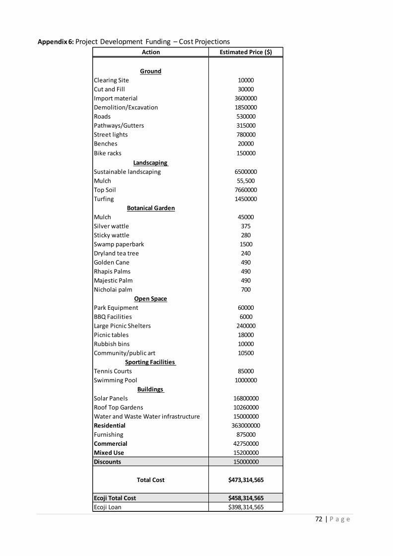
72 | P a g e
Action Estimated Price ($)
Ground
Clearing Site 10000
Cut and Fill 30000
Import material 3600000
Demolition/Excavation 1850000
Roads 530000
Pathways/Gutters 315000
Street lights 780000
Benches 20000
Bike racks 150000
Landscaping
Sustainable landscaping 6500000
Mulch 55,500
Top Soil 7660000
Turfing 1450000
Botanical Garden
Mulch 45000
Silver wattle 375
Sticky wattle 280
Swamp paperbark 1500
Dryland tea tree 240
Golden Cane 490
Rhapis Palms 490
Majestic Palm 490
Nicholai palm 700
Open Space
Park Equipment 60000
BBQ Facilities 6000
Large Picnic Shelters 240000
Picnic tables 18000
Rubbish bins 10000
Community/public art 10500
Sporting Facilities
Tennis Courts 85000
Swimming Pool 1000000
Buildings
Solar Panels 16800000
Roof Top Gardens 10260000
Water and Waste Water infrastructure 15000000
Residential 363000000
Furnishing 875000
Commercial 42750000
Mixed Use 15200000
Discounts 15000000
Total Cost $473,314,565
Ecoji Total Cost $458,314,565
Ecoji Loan $398,314,565
Appendix 6: Project Development Funding – Cost Projections